Showing 1048 items
matching central road.
-
 Ringwood and District Historical Society
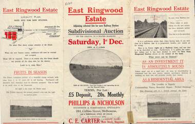
Flyer, Subdivisional Auction Sale Brochure, East Ringwood Estate, Vic. - 1923
Tri-folded double sided advertisement for subdivisional auction sale on Saturday, 1st December, 1923, including location map and summary of local facilities and services.Subdivision includes Patterson Street, Bona Street, Miller Grove, Fairview Avenue and Eastfield Road. Auctioneer - Phillips & Nicholson, 281 Collins Street, Melbourne. Tel. Central 10907. Agent - C.E. Carter, Main Street, Ringwood. Tel. Ringwood 24. -
 Ringwood and District Historical Society
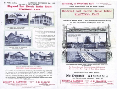
Flyer, Land Sale Auction Brochure, Electric Station Estate, Ringwood East, Vic. - 1924
Folded double-sided advertisement for Ringwood East Electric Station Estate subdivisional sale of retail and residential allotments by public auction on Saturday, 1 November, 1924, with local photographs, terms of sale, and summary of subdivision features and local facilities. Subdivision includes Railway Parade (later Patterson Street, Rosedale Crescent, Federal Road, Howship Avenue (later Howship Court and French Street), and Dublin Road. (Agents) Knight & Harwood, 315 Collins Street, Melbourne, Phone Central 10615, 10616, in conjunction with J.B. McAlpin, Opposite Railway Station, Ringwood, Phone Ringwood 7. -
 Ringwood and District Historical Society
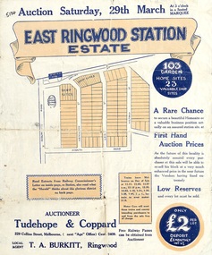
Flyer, Land Sale Auction Brochure, East Ringwood Station Estate - 1924
Bi-folded double sided sheet with yellow and blue print advertising auction of retail and residential allotments on Saturday, 29 March (1924), including details of subdivision features and local facilities. Subdivision includes Station Street, Wenwood Street, Lois Street, Victoria Street. Auctioneer - Tudehope & Coppard, 229 Collins Street, Melbourne, Tel. Central 2409, in conjunction with local agent, T.A. Burkeitt, Ringwood, Tel. Ringwood 157. -
 Ringwood and District Historical Society
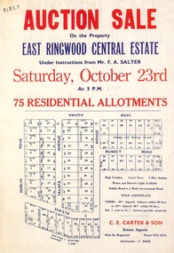
Flyer, Land Auction Sale Advertisement, East Ringwood Central Estate - 1948
See Victorian Collections reference 5125 for subsequent Central Estate East Ringwood subdivision flyer.Single sided land auction sale advertisement for residential allotments.Auction Sale on the property under instructions from Mr. F.A. Salter. Subdivision includes Dublin Road, Knaith Road, Talofa Avenue, Russet Road, and Shasta Avenue. Agent - C.E. Carter & Son, Main Street, Ringwood. WU 6024. -
 Ringwood and District Historical Society
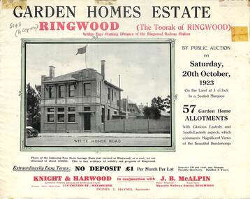
Flyer, Subdivisional Land Auction Sale Brochure, Garden Homes Estate, Ringwood, Vic. - 1923
Double sided multi-folded page advertising auction sale of residential allotments highlighting local facilities, services and layout of the estate. Includes panoramic view of Ringwood and other local photographic images.Subdivision includes Mullum Mullum Road, The Centreway, Wattle Crescent and Reserve Crescent. Agents - Knight & Harwood, 315 Collins Street, Melbourne, Phone 10615, 10616 Central, in conjunction with J.B. McAlpin, Opposite Railway Station, Ringwood. Phone Ringwood 7. -
 Ringwood and District Historical Society
Flyer, Subdivisional Land Auction Sale Brochure, Grand Central Estate, Ringwood, Vic. - 1925
Douglas Street shown in the estate plan did not eventuate, but was developed as a public reserve. Refer also to Reg. No. 5149 for 1924 auction sale of land also titled Grand View Estate situated further north in Ringwood.Double sided multi-folded page advertising public auction sale on Saturday, 31st October, 1925, of residential allotments highlighting local facilities, services and layout of the estate. Includes panoramic view of Ringwood and other local photographic images.Subdivision includes Great Ryrie Street, Heathmont Road, Douglas Street, Garden Street, and Bellevue Avenue. Agents - Knight & Harwood, 315 Collins Street, Melbourne, Phone 10615, 10616 Central, in conjunction with J.B. McAlpin, Opposite Railway Station, Ringwood. Phone Ringwood 7. -
 Ringwood and District Historical Society
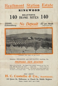
Flyer, Land Sale Brochure, Heathmont Station Estate, Ringwood, Vic. - circa 1925
Extract of "Herald" 2/2/22: The intention of the Railway Commissioners is to electrify the line to the Gully as soon as convenient, and with greater frequency of service many persons settled, and settling, in the district will be benefited. There is a scheme which may be launched that will allow for an express service of fast trains to the Gully. The commissioners are alive to the necessity for assisting to settle the picturesque districts between Box Hill and Gembrook.Bi-fold advertisement for sale of retail and residential sites, including panoramic and other photographs, map, and summary of subdivision features and local facilities. Subdivision includes Canterbury Road, Station Street (later Wainui Avenue), Lisgoold Street, Viviani Crescent, and Balfour Avenue. Agent - H.C. Costello & Co., Auctioneer, 128 Queen Street, Melbourne, or Church Street, Middle Brighton. Phones: Central 10517 and X1205. -
 Ringwood and District Historical Society
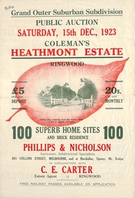
Flyer, Land Sale Brochure, Coleman's Heathmont Estate, Ringwood, Vic. - 1923
Bi-fold advertisement for auction sale of residential sites, including photographs, map, and summary of subdivision features and local facilities. Auction date Saturday 15th December, 1923. Subsequent auction date Saturday 19th January, 1924, following previous sale stopped on account of rain. Initial newspaper advertisement (publication unknown) dated 16/11/23.Subdivision includes Bedford Road, Canterbury Road, Alvena Crescent, Leonard Street (later Royal Avenue), and Coleman Street. Agent - Phillips & Nicholson, 281 Collins Street Melbourne, (Phone) Central 10907, in conjunction with C.E. Carter, Main Street, Ringwood. Tel. Ringwood 24. -
 Flagstaff Hill Maritime Museum and Village
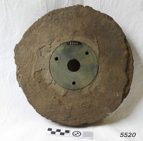
Functional object - Pulley Sheave, 1873
A sheave is a pulley with a grooved wheel for holding a belt, wire rope, or rope. The grooved wheel spins on an axle or bearing inside the frame of the block. This allows the wire or rope to move freely minimizing friction and wear on the cable. Sheaves can be used to redirect a cable or rope, lift loads, and transmit power. The words sheave and pulley are sometimes used interchangeably. The sheave was recovered at the time of the discovery of the Loch Ard wreck site in the 1970s. History of the Loch Ard: The Loch Ard got its name from ”Loch Ard” a loch that lies to the west of Aberfoyle, and the east of Loch Lomond. It means "high lake" in Scottish Gaelic. The vessel belonged to the famous Loch Line which sailed many vessels from England to Australia. The Loch Ard was built in Glasgow by Barclay, Curdle and Co. in 1873, the vessel was a three-masted square-rigged iron sailing ship that measured 79.87 meters in length, 11.58 m in width, and 7 m in depth with a gross tonnage of 1693 tons with a mainmast that measured a massive 45.7 m in height. Loch Ard made three trips to Australia and one trip to Calcutta before its fateful voyage. Loch Ard left England on March 2, 1878, under the command of 29-year-old Captain Gibbs, who was newly married. The ship was bound for Melbourne with a crew of 37, plus 17 passengers. The general cargo reflected the affluence of Melbourne at the time. Onboard were straw hats, umbrellas, perfumes, clay pipes, pianos, clocks, confectionery, linen and candles, as well as a heavier load of railway irons, cement, lead and copper. There were other items included that were intended for display in the Melbourne International Exhibition of 1880. The voyage to Port Phillip was long but uneventful. Then at 3 am on June 1, 1878, Captain Gibbs was expecting to see land. But the Loch Ard was running into a fog which greatly reduced visibility. Captain Gibbs was becoming anxious as there was no sign of land or the Cape Otway lighthouse. At 4 am the fog lifted and a lookout aloft announced that he could see breakers. The sheer cliffs of Victoria's west coast came into view, and Captain Gibbs realised that the ship was much closer to them than expected. He ordered as much sail to be set as time would permit and then attempted to steer the vessel out to sea. On coming head-on into the wind, the ship lost momentum, the sails fell limp and Loch Ard's bow swung back towards land. Gibbs then ordered the anchors to be released in an attempt to hold their position. The anchors sank some 50 fathoms - but did not hold. By this time the ship was among the breakers and the tall cliffs of Mutton Bird Island rose behind. Just half a mile from the coast, the ship's bow was suddenly pulled around by the anchor. The captain tried to tack out to sea, but the ship struck a reef at the base of Mutton Bird Island, near Port Campbell. Waves subsequently broke over the ship and the top deck became loosened from the hull. The masts and rigging came crashing down knocking passengers and crew overboard. When a lifeboat was finally launched, it crashed into the side of Loch Ard and capsized. Tom Pearce, who had launched the boat, managed to cling to its overturned hull and shelter beneath it. He drifted out to sea and then on the flood tide came into what is now known as Loch Ard Gorge. He swam to shore, bruised and dazed, and found a cave in which to shelter. Some of the crew stayed below deck to shelter from the falling rigging but drowned when the ship slipped off the reef into deeper water. Eva Carmichael a passenger had raced onto the deck to find out what was happening only to be confronted by towering cliffs looming above the stricken ship. In all the chaos, Captain Gibbs grabbed Eva and said, "If you are saved Eva, let my dear wife know that I died like a sailor". That was the last Eva Carmichael saw of the captain. She was swept off the ship by a huge wave. Eva saw Tom Pearce on a small rocky beach and yelled to attract his attention. He dived in and swam to the exhausted woman and dragged her to shore. He took her to the cave and broke the open case of brandy which had washed up on the beach. He opened a bottle to revive the unconscious woman. A few hours later Tom scaled a cliff in search of help. He followed hoof prints and came by chance upon two men from nearby Glenample Station three and a half miles away. In a complete state of exhaustion, he told the men of the tragedy. Tom then returned to the gorge while the two men rode back to the station to get help. By the time they reached Loch Ard Gorge, it was cold and dark. The two shipwreck survivors were taken to Glenample Station to recover. Eva stayed at the station for six weeks before returning to Ireland by steamship. In Melbourne, Tom Pearce received a hero's welcome. He was presented with the first gold medal of the Royal Humane Society of Victoria and a £1000 cheque from the Victorian Government. Concerts were performed to honour the young man's bravery and to raise money for those who lost family in the disaster. Of the 54 crew members and passengers on board, only two survived: the apprentice, Tom Pearce and the young woman passenger, Eva Carmichael, who lost her family in the tragedy. Ten days after the Loch Ard tragedy, salvage rights to the wreck were sold at auction for £2,120. Cargo valued at £3,000 was salvaged and placed on the beach, but most washed back into the sea when another storm developed. The wreck of Loch Ard still lies at the base of Mutton Bird Island. Much of the cargo has now been salvaged and some items were washed up into Loch Ard Gorge. Cargo and artefacts have also been illegally salvaged over many years before protective legislation was introduced in March 1982. One of the most unlikely pieces of cargo to have survived the shipwreck was a Minton majolica peacock- one of only nine in the world. The peacock was destined for the Melbourne 1880 International Exhibition. It had been well packed, which gave it adequate protection during the violent storm. Today the Minton peacock can be seen at the Flagstaff Hill Maritime Museum in Warrnambool. From Australia's most dramatic shipwreck it has now become Australia's most valuable shipwreck artifact and is one of very few 'objects' on the Victorian State Heritage Register. The shipwreck of the Loch Ard is of significance for Victoria and is registered on the Victorian Heritage Register ( S 417). Flagstaff Hill has a varied collection of artefacts from Loch Ard and its collection is significant for being one of the largest accumulation of artefacts from this notable Victorian shipwreck. The collections object is to also give us a snapshot into history so we can interpret the story of this tragic event. The collection is also archaeologically significant as it represents aspects of Victoria's shipping history that allows us to interpret Victoria's social and historical themes of the time. The collections historically significance is that it is associated unfortunately with the worst and best-known shipwreck in Victoria's history. Pulley sheave; round wooden block with metal disc in centre. Metal disc has large central machined hole and three equidistant small holes closer to the edge. Part of the rope groove is uneven. Recovered from the wreck of the Loch Ard. Noneflagstaff hill, warrnambool, shipwrecked coast, flagstaff hill maritime museum, maritime museum, shipwreck coast, flagstaff hill maritime village, great ocean road, loch line, loch ard, captain gibbs, eva carmichael, tom pearce, glenample station, mutton bird island, loch ard gorge, pulley sheave, pulley, ship rigging -
 Frankston RSL Sub Branch
Unknown - RAAF Tie Bar/Trench Art, RAAF Tie Bar
Decorative tie bar to be worn socially and to signify a present or past association with the RAAFSilvered tie bar with silver suspension chain attached either end. Centrally attached to the chain is a small RAAF badge with extended wings. -
 Bendigo Military Museum
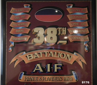
Honour Board - 38th BN BATTLE HONOURS, Unknown
This board shows there are 7 Battle Honours which includes South Africa 1898 - 1902. This is due to Lineage pre the formation of the 38th BN in June 1916 in Bendigo. Refer Cat No 4435 for the actual 38th Bn Colours. This item is on display in the rear foyer entrance of the Bendigo District RSL in Havilah Road. Refer Cat No 8141P for the history of donation and placement across the RSL.Large board with brown/red background with ornate edge all round, each side are the Battle Honours of the Battalion in scroll formation, at the top central is the Colour Patch of the Battalion, the “38th” under that then”Battalion AIF”, at the bottom in a scroll is “France & Flanders 1916 - 18”brsl, smirsl, bdrslinc, 38th, battle honours -
 Bendigo Military Museum
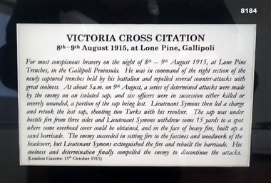
Print - FRAMED PRINT, LT SYMONS VC, Unknown
Lieutenant William Symons VC. Refer to photo for his citation. This item is on display in the Bendigo District RSL Havilah Road.Photograph framed, timber frame brown colour, dark background with central photo in an oval shape of a soldier in a side on portrait position, an inset on white is his name and unit, under that the Rising Sun Badge left, centre is the citation re the award of the Victoria Cross, on the right is an image of a VC.“W SYMONS VC 7th Infantry Bn 1st AIF (Eaglehawk)”brsl, smirsl, bdrslinc, symons, vc -
 Bendigo Military Museum
Photograph - Johnson Ground Elevation Meter (JGEM) Survey Vehicle - Army Survey Regiment, Fortuna, Bendigo, c1960s
This is a set of 16 photograph of the Royal Australian Survey Corps’ Johnson Ground Elevation Meter (JGEM) Survey Vehicle taken at the Army Survey Regiment, Fortuna, Bendigo. The JGEM vehicle was extensively used by RA Svy within Australia from the late 1960s. A limited number of Ground Elevation Meter (GEM) station wagon type vehicles were manufactured by General Motors Corporation (GMC) in the USA for the United States Geological Survey, Canada’s mapping agencies, RA Svy and National Mapping (Natmap). The GEM was a four-wheel drive, four-wheel steer vehicle. Four-wheel steering was necessary to avoid systematic errors caused by non-tracking of front and rear wheels on conventionally steered vehicles. The manufacturer substituted the rear axle with a front axle and connected them to form the four-wheel steering mechanism. The two Australian GEM vehicles, referred to as Johnson GEMs (JGEMs) were converted into right-hand drive. After delivery in 1964, acceptance Natmap and RA Svy testing and operator training was undertaken at the Army's School of Military Survey located at Balcombe, Victoria. A small fifth wheel was mounted on a cantilever arm suspension midway between the front and rear wheels on the right side of the vehicle. It was lowered to and raised from its operating position by use of a constant pressure air cylinder. A telescopic bar, suspended between the front and rear axles, provided the reference datum for the angle measurement. The wheel provided the velocity or distance signal through a pulse generator system. A sensitive pendulum mounted on this bar provided the angle measurement for each minute distance traversed. The JGEM contained electromechanical instruments used to determine relative elevations, by trigonometric principles, along a traversed path. These relative elevations were obtained through apparatus which measures the instantaneous angle of inclination of the road and the instantaneous velocity of the meter along such a path. Road routes over which the JGEM operated were planned so that each started and ended as near as practicable to an existing point of known elevation (formally referred to as a level traverse bench mark). The difference in height from the bench mark and the road surface alongside the JGEM’s fifth wheel was measured with a level and staff. Along each route, mapping control photo reference points where new elevation values were required were identified on aerial photographs. Under favourable conditions it was possible to survey as much as 160km in an ordinary working day. The first of RA Svy’s JGEM operations was undertaken in 1:250,000 scale map areas of Queensland. CPL John Hook was the JGEM’s main operator in the early 1970s undertaking operations covering 1:250,000 scale map blocks over northern Victoria and central NSW, each requiring 36 points (9 runs of photography and 4 points across. SPR Lyn Thompson and SPR Bob McDonagh teamed with CPL Hook on some of these JGEM operations. When RA Svy was integrated into the Royal Australian Engineers in 1996, the JGEM vehicle with the Survey Corps collection was donated to its museum. It is believed to be the last of the original manufactured fleet in existence. The JGEM has undergone extensive refurbishment to achieve roadworthiness and is currently housed at The Australian Army Museum of Military Engineering, Hoslworthy Barracks, NSW. It can be viewed by making an appointment with the museum’s curator.This is a set of 16 photograph of the Royal Australian Survey Corps’ Johnson Ground Elevation Meter (JGEM) Survey Vehicle taken at the Army Survey Regiment, Fortuna, Bendigo. The photographs were on 35mm slide film and were scanned at 96 dpi. They are part of the Army Survey Regiment’s Collection. .1) - Photo, colour, c1960s, Johnson Ground Elevation Meter (JGEM) Survey Vehicle .2) - Photo, colour, c1960s, JGEM instrumentation, on-board computer. .3) - Photo, colour, c1960s, JGEM instrumentation. .4) - Photo, colour, c1960s, JGEM instrumentation, on-board computer. .5) - Photo, colour, c1960s, JGEM tyre pressure controller .6) - Photo, colour, c1960s, JGEM rear doors, SGT Geoff Briggs. .7) - Photo, colour, c1960s, JGEM 5th wheel distance/angle measurement device in lowered position, SGT Geoff Briggs. .8) - Photo, colour, c1960s, JGEM 5th wheel distance/angle measurement device in lowered position. .9) & .10) - Photo, colour, c1960s, JGEM tyre pressure system, SGT Geoff Briggs. .11) - Photo, colour, c1960s, JGEM tyre pressure system. SGT Geoff Briggs. .12) - Photo, colour, c1960s, JGEM levelling scope, levelling staff, unidentified technicians. .13) & .14) - Photo, colour, c1960s, JGEM levelling scope, unidentified technician. .15) & .16) - Photo, colour, c1960s, probably survey operation adjusted height plotted on block base sheet. .1P to .16P - Some of the equipment is annotated on the frame of the 35mm slides.royal australian survey corps, rasvy, army survey regiment, army svy regt, fortuna, asr, surveying -
 Warrnambool and District Historical Society Inc.
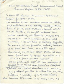
Annual Report, Save the Children Fund 1984-1985, C1985
These pages contain details of the local branch of the Save The Children's Fund. it records events such as film and card luncheons and street stalls which all contributed to fund raising efforts of the group. Names which are mentioned include Central Court Motel, Stan Stephens and the Capitol Theatre,Mrs D Ogier, Mr & Mrs Merryne Ritchie, Warrnambool golf course, Sir Brian Murray Mr & Mrs K Swinton,, Mrs Shirley Taylor and Mrs Tup Isles This report has social significance as it contains names of local people and records the types of activities in which the group participated Five pages of handwritten notes from exercise book. Written in blue biro.Pls type for mrs tait written in greylead at top of first page . Annual report 1984-1985.warrnambool, warrnambool save the children fund -
 Warrnambool and District Historical Society Inc.
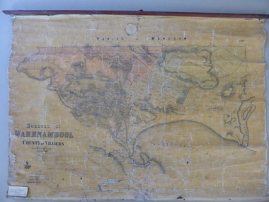
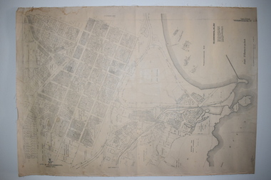
Mao, Borough of Warrnambool, County of Villiers, 1873
This is an early map of the Borough of Warrnambool (1872/3) showing the central town area of Warrnambool and the surrounding district. Reserves, public buildings and some businesses are marked. The map was photolithographed by John Noone, a Melbourne artist and photographer who claimed in 1858 to have the oldest-existing photographic studio in Melbourne. Photolithography was a process first developed in Melbourne. For several years Noone was the official photographer for the Victorian Crown Lands Office and for the Victorian Public Library and Museum. The map has the stamp of the seller of the map – Charles Hider, the well-known stationer and bookseller in Timor Street, Warrnambool. The owner of the map, Henry George Marfell, (1883-1962) was the son of John and Mary Ann Marfell. The Marfells were well-known in Warrnambool as grain merchants and managers of the Warrnambool Co-Operative Milling Company. It is surmised from the writing on the Marfell label that this map was at some stage given by Henry Marfell to the old Warrnambool MuseumThis map of early Warrnambool is of considerable significance, firstly because its original state and early date (1873) make it of antiquarian and historical interest. Also the connection with the names, Charles Hider and Henry Marfell and the old Museum gives it added provenance and interest.This is a wax paper map mounted on cloth. At the top it is attached by nails to a piece of wood and at the top it has a cloth ring for hanging the map. The map is in black shadings on a yellow background. The map is badly creased and coming away from the cloth at the edges and at other various points. There is some red or pink marking or staining on the township area of the map (originally the sold lands on this map were coloured in brown and the reserves, buildings, etc in pink). On the left hand corner there is a piece of paper glued on with some handwriting in ink (Marfell). There is also the stamp of the seller of the map – Charles Hider, stationer and bookseller, of Timor Street Warrnambool‘Early Map of W’bool, H.G. Marfell’ history of warrnambool, charles hider, henry marfell -
 Warrnambool and District Historical Society Inc.
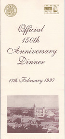
Document, Menu 150th, 1997
This is the program for the dinner celebrating Warrnambool’s 150th anniversary. Warrnambool was established in 1847 as a planned town in response to the need for a new port to be established to service the pastoralists who had occupied land nearby. Superintendent La Trobe authorized the establishment of the town and probably gave it its name. The surveyor of the 250 acre grid that today comprises most of the Central Business District was William Pickering. The 150th anniversary celebrations were organized by an 150th Anniversary Committee headed by Frank JacobsThis program is of minor interest as a memento of the important 150th anniversary celebrations held in Warrnambool in 1997. This is a buff-coloured A3–size sheet folded into three to make six pages of printed material. These include sepia-tone photographs, the menu for the dinner, the official crest of the Warrnambool City Council and the 150th anniversary celebrations logoFront cover: ‘Official 150th Anniversary Dinner, 17th February 1997’warrnambool’s 150 anniversary celebrations -
 Warrnambool and District Historical Society Inc.
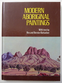
Book, Modern Aboriginal Paintings, 1976
This is a book produced by Rex and Bernice Battarbee and contains reproductions of aboriginal art work, including the work of several of Albert Namatjira’s children. Reginald (Rex) Battarbee (1893-1973) was the son of George and Mary Battarbee who lived in East Warrnambool at a property called ‘Skiddaw’. Rex’s sister, Florinda was a local artist who was his first teacher of art. Rex became a well-known artist, depicting mainly the Central Australian landscape. He is credited with discovering and fostering the artistic talent of Albert Namatjira, the best-known of the early Australian aboriginal artists. This is one of the few mementoes we have of the artist Rex Battarbee who was born in Warrnambool and spent his early years in this city. This is a hard cover book with the pages unnumbered. The cover is brown with colour reproductions of two aboriginal paintings on the front and back cover. The printing on the front cover is in yellow and white lettering. The book contains written text and many reproductions of aboriginal paintings. The inscription on the first page is handwritten in black biro. ‘L. Durrant, From Russ, May 1979’. rex battarbee, aboriginal art, albert namatjira -
 Warrnambool and District Historical Society Inc.
Documents Maps (3) - Warrnambool Town Allotments, City of W'bool Parish of Wangoom Country of Villiers, 1948
These maps were produced in 1948 and they contain maps of allotments within the city of Warrnambool, including the Central Business District, up to 1948. The details given on each allotment show the allotment and section numbers, the measurement in acres, the name of the original purchaser of the lot and the date of the first sale. The Warrnambool and District Historical Society owns several copies of these maps but these ones are originals.These three maps are of great significance because they give the names of land purchasers in Warrnambool from the date of the first land sales in 1847. They are a most valuable research tool and can be scanned and photocopied etc.These are three sheets of cream paper pasted on to linen. The sheets have black and white printing and map work. Some of the edges are a little frayed and there is some staining, particularly on the backs of the sheets.‘City of Warrnambool Parish of Wangoom County of Villiers Sheet 1’ ‘City of Warrnambool Parish of Wangoom County of Villiers Sheet 2’ ‘City of Warrnambool Parish of Wangoom County of Villiers Sheet 3’city of warrnambool, warrnambool maps, warrnambool town allotments 1948, land purchases -
 Christ Church Anglican Parish of Warrnambool
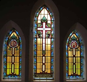
Memorial windows: James Fraser and Bertha JUKES
Three lancet stained glass windows. The window on the left has the symbol IHS, an abbreviation of the Greek word for Jesus. The central window has an empty cross, the right window has the Alpha and Omega symbolising 'the beginning and the end/the first and last'.To the Glory of God. In memory of / James Fraser and Bertha Jukes./ Erected by their children.jukes, james jukes, bertha jukes -
 Christ Church Anglican Parish of Warrnambool
Memorial Windows: Jubilee of Queen Victoria, Jubilee of Queen Victoria
... -ocean-road The central lancet window has: To the Glory of God ...Four stained glass windows, west wall, main nave. A circular window in the gable of the wall showing the Royal Coat of Arms. Three lancet windows below depicting, from left to right, Faith, Hope and Charity.The central lancet window has: To the Glory of God/and in commemoration of the com/ pletion of the fiftieth year of the happy reign/ of Her most Gracious Majesty/ QUEEN VICTORIA/ 1887 -
 Warrnambool and District Historical Society Inc.
Souvenir Glass, South West HealthCare celebrating 150 years, 2004
The Warrnambool hospital was commenced around 1850 with the establishment of a benevolent society but little is known of the early days. Over 150 years the hospital has been an imposing building and central part of the Warrnambool community. A common item with links to a major establishment in the city.Clear stemmed glass with white lettering on side in white.South West Health Care celebrating 150 years with logo above lettering.warrnambool base hospital, 150 years warrnambool hospital -
 Warrnambool and District Historical Society Inc.
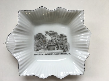
Dish, Warrnambool Botanic Gardens, C early to mid 20th century
The Rotunda in the Warrnambool Botanic gardens was constructed in 1913 at a cost of 297 pounds. It is situated toward the central eastern side of the gardens and is visible from many viewpoints in the gardens. The building is octagonal in shape with a steeply pitched tiled roof with the bandstand open area elevated to approximately 3 metres. The gardens designed by William Guilfoyle, commenced in 1866 have been a popular meeting place as well as entertainment and social community events. This dish would have been a souvenir or memento. A common souvenir type object .Small white china dish with square baseand fluted sides and lined edge.Transfer print of the rotunda at the Warrnambool Botanic gardens in black. fine black line around edge of dish.Botanic Gardens Warrnambool in black text below print on front of dish, made in Cechoslov 12 below crown with RKG inside the crown.warrnambool, warrnambool gardens rotunda, warrnambool botanic gardens -
 Warrnambool and District Historical Society Inc.
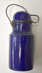
Domestic object - Thermos, c. 1920
This is a vintage item from the early 20th century. It could have been used in a house hold context or by farmers in the paddocks, by hikers, family picnickers, campers or by workers in factories. This item has no known provenance and is kept as an interesting vintage domestic object..Deep blue enamel vacuum flask or thermos with a rusted metal handle and a lid which serves as a cup. There are rust patches on the base, sides and cup. The central section is round.vintage domestic item, vintage vacuum flask, vintage thermos -
 Warrnambool and District Historical Society Inc.
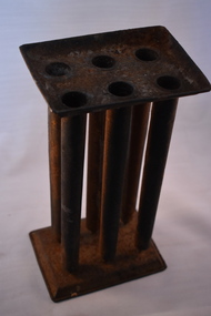
Household, Candle mould, Early 20th century
This candle mould was used in the past to make six candles. Molten wax or tallow, together with a central thread or cotton, were poured into the columns and when set were removed from the moulds. Until the advent of electricity in the 1920s in Warrnambool, candles, lanterns and lamps were an important source of lighting in homes. Few homes had gas lighting. Many householders made their own candles from waste fat etc. This mould is retained as an example of the way householders in the past made their own candles to assist lighting in the home. This is a mould with a rectangular base and six cylindrical hollow columns with pointed ends affixed to the mould base. The columns are topped by a rectangular metal tray with the openings of the columns in the base of the tray. There is a metal clip attached to one end of the tray. The mould is very rusty warrnambool history, candles -
 Warrnambool and District Historical Society Inc.
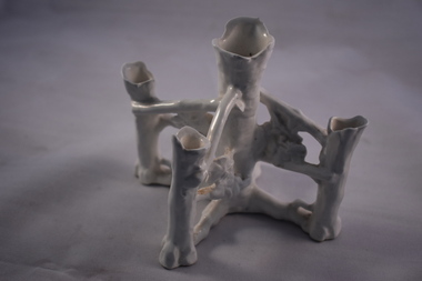
Household, Vase, Early 20th century
This vase would have been used to hold five small flowers or fronds and would have been a decorative item on a dining table or mantelpiece. Today a vase holding one or a small number of flowers is called a specimen vase and the style of these tends to be less decorative than the item described here. This item has no known local provenance but is retained as an example of a household item from the past.This is a white china vase with a central pillar representing the trunk of a tree and (originally) four pillars branching out from the main pillar to represent the branches of a tree. One of these pillars is now missing. The china stems holding the branch columns have embossed flowers and fronds. The main pillar and the branch pillars have irregular-shaped openings for flower insertion.household items, history of warrnambool -
 Warrnambool and District Historical Society Inc.
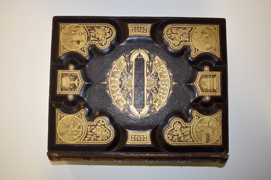
Book, Hubbard Brothers, Holy Bible, Late 19th century
This Bible originally belonged to members of the Orr family who came from Scotland and had a property at Addington near Learmonth in central Victoria (from the 1860s). Many families in the 19th and early 20th centuries had family bibles which were read individually by family members or read aloud to family members, especially on a Sunday. Many of these large-size bibles were used to record family information (births, deaths, marriages), though this one does not have any information recorded. This Bible is retained as a splendid example of a 19th century family Bible. It will be very useful for display. This is a hard-cover book with gilt edging on the pages. It has a leather cover with heavy gold embossing on the front and back covers. Inserted in the embossing are gold religious symbols and images. The Bible contains 45 chapters with the Old and New Testaments and other biblical and religion- related articles. There are many black and white illustrations and some colour illustrations. There is a slight evidence of silverfish damage. ‘Holy Bible’ orr family, family bibles, history of warrnambool -
 Warrnambool and District Historical Society Inc.
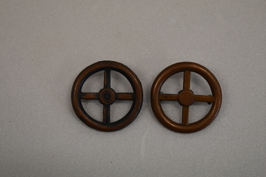
Badges x 2, Wheel Shaped
These badges appear to come from the transport section of the British Army and would have been worn on the shoulder. They would have been in use during the first half of the 20th Century.These badges do not appear to have local significance but are of interest as early examples od British Army Transport Corps badges..1 Circular shaped badge with annulus, central hub and four spokes resembling a wheel. There are two small rings on the perimeter of the reverse. .2 Identical with .1 but has an additional circle in the hub and is discoloured.Nil -
 Warrnambool and District Historical Society Inc.
Documents, Late 20th, early 21st centuries
These ten documents (maps, plans, photographs) mostly come from the Warrnambool City Council and most contain information on sub-divisions and titles of properties in areas around the Central Business District of Warrnambool. The dates range from 1986 to 2006. These maps, plans and photographs are of some interest as they give historical details of subdivisions in Warrnambool and date from the late 20th century. .1 This is a laminated map of the boundaries of Local Governments in Victoria. It is Sheet I of 2 and has red and blue pencil markings and black boundary markings. .2 This is a copy of a plan of a survey in black and white markings on paper. .3 This is a plan of the title details of Section 19 Warrnambool. It has black printing on buff-coloured paper. .4 This is a plan of the allotments in part of the Central Business District of Warrnambool. It is printed in black and white. .5 This is a 2006 coloured aerial photograph of the harbour at Warrnambool – Breakwater etc. .6 This is a 2006 coloured aerial photograph of the Lake Pertobe area in Warrnambool .7 This is a coloured aerial photograph of Warrnambool’s streets over-stamped with road numbers in large blockings. .8 This is a plan showing the title details of Section 11 in Warrnambool. It has black printing on buff-coloured paper. .9.1 This is a plan of sub-divisions in parts of Crown Allotments 38 & 39 in Warrnambool. It has green, pink and yellow markings with black printing. .9.2 This is a plan of the sub-divisions in parts of Allotments 38 & 39 in Warrnambool. It has pink, yellow and blue markings with black printing. It is somewhat faded. warrnambool c.b.d. maps and plans, history of warrnambool -
 Eltham District Historical Society Inc
Photograph, Liz Pidgeon, EDHS Heritage Walk: Shillinglaw Farm, Eltham, 2 September 2023
On Saturday September 2, 2023, Russell Yeoman led a group of 22 society members and interested others on a walk following trhe bounadries of the original Shillingalw farm. Commencing at the corner of Panther Place and Library Place, we proceeded up to Shillinglaw Cafe then the Shillinglaw trees at the former Eltham Shire Office site then along Main Road to the fire station then throughh St Laurence Lane and uinder the railway line , along Diamond Street then return via the Diamond Creek trail behind Andrew Park. The actual farm boundary went past the creek and further up the hill. The original farm comprised lot 90 of Holloway’s 1851 subdivision of Little Eltham. Its area was 30 acres lying east of the Diamond Creek and north of Henry Street. A number of stops were made to look at maps and early photos illustrating the gradual reduction of the farm area and the early history of the railway and other community uses, that occupied parts of the site.2023-09-02, activities, eltham, eltham district historical society, heritage excursion, shillinglaw farm, 895 main road, amplifon, andrew park, andrew pocket park, arthur street, bar de tapas, barber shop, barry plant estate agent, blockbuster, bus depot, car park, carparks, central park, cleaver & co hair, commonwealth bank, crust pizza, divine bridal, dr ash constance, dudley street, eltham book shop, eltham convenience store, eltham fire station, eltham library, eltham newsagency, eltham optical, eltham railway station, eltham shops, fay bridge, fire bell, flagpole, flight centre, grill'd, information sign, iso chook, jellis craig estate agent, judge book village, kebab nation, kx pilates, la zanyas, liquorland, little drop of poison, lorraine jones & associates solicitors, luck street, machan indian restaurant, main road, mecho en mexico, missing gorilla, morrison kleeman real estate, pavilion menswear, platform 3095, playtherapy melbourne, pryor street, ray white real estate, restaurants, sage bulk whole foods, shillinglaw trees, sign, snap fitness, southern cross medical imaging, specsavers, st laurence lane, st vincents care service, thompson's pharmacy, todaro, united service station, vyve body & skin, welcome to eltham town, westpac bank, yang's kitchen, youth road -
 Eltham District Historical Society Inc
Photograph - Aerial Photograph, Landata, Montmorency, Feb. 1956
Centred on present day Tahlee Place Reserve and Sherbourne Preschool, Montmorency bounded by Progress Road to north, Withers Way to south, Main Road to east and Leach Street to west. Historic Aerial Imagery Source: Landata.vic.gov.au Aerial Photo Details: Project No :250 Project : MELBOURNE OUTER SUBURBS PROJECT Run : 17 Frame : 114 Date : 02/1956 Film Type : B/W Camera : EAG9 Flying Height : 10000 Scale : 12000 Film Number : 1176 GDA2020 : 37°42'50"S, 145°08'02"E MGA2020 : 335512, 5824286 (55) Melways : 21 F5 (ed. 42)aerial photo, 1956-02, neil webster collection, central park, eltham, leach street, main road, melway 21f5, montmorency, progress road, withers way, sherbourne preschool, tahlee place reserve