Showing 162 items
matching crown lands department
-
 Victorian Aboriginal Corporation for Languages
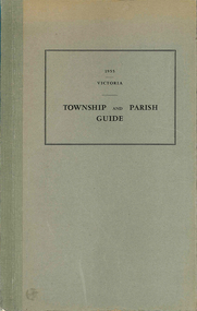
Book, Department of Crown Lands and Survey Victoria, Township and parish guide : Victoria, 1955
... Department of Crown Lands and Survey Victoria... of Crown Lands and Survey Victoria ...A alphabetical list of townships proclaimed under the Land Acts of Victoria. Shows the parish, land district and the municipality in which each is situated, and the particulars of Gazettal of Proclamation.victorian geographical names, victorian administration -
 University of Melbourne, Burnley Campus Archives
Document - Circular, Department of Crown Lands and Survey. Complete list of weeds declared noxious in the State of Victoria, 1964-1972
... Department of Crown Lands and Survey. Complete list of... and Noxious Weeds Act 1928) Department of Crown Lands and Survey ...Chart prepared by Vermin and Noxious Weeds branch. Plants proclaimed under the Noxious Weeds Act 1928 (No 3799) for the State of Victoria.. Plants proclaimed within certain Municipalities of Victoria. Includes tables of Chemical Treatment and other remarks.Large circular - Complete list of weeds proclaimed noxious within the State of Victoria and for certain Municipalities and table of quantities for chemical treatment together with brief instructions for treatment of Noxious Weeds (Vermin and Noxious Weeds Act 1928)weeds, vermin and noxious weeds act 1928, chemical treatment of weeds -
Clunes Museum
Document (Item), DEPARTMENT OF LANDS AND SURVEY, RENEWALS GARDEN LICENCE 5/
RECEIPT BOOK DEPARTMENT OF LANDS AND SURVEY. LICENCE TO ENTER UPON CROWN LANDS NOT EXCEEDING IN AREA ONE ACRE, AS SPECIFIED HEREUNDER, FOR PURPOSES OF GARDEN AND RESIDENCE. FEE PER ANNUM 5 / O (FIVE SHILLINGS) FIFTY CENTSlocal history, local government, council, licence, garden -
Clunes Museum
Administrative record - BOOK, GARDEN LICENCE 5/
RECEIPT BOOK. DEPARTMENT OF LANDS AND SURVEY. LICENCE TO ENTER UPON CROWN LANDS NOT EXCEEDING IN AREA ONE ACRE AS SPECIFIED, HEREUNDER FOR PURPOSE OF GARDEN AND RESIDENCE.BLUE COVERED RECEIPT BOOK CONTAINING PAYMENTS FOR GARDEN LICENCE NOd 188181 TO 188200 DATED MARCH 1885 TO NOVEMBER 1885local history, local gov., council, licence, garden -
 Peterborough History Group
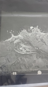
Photograph - Aerial Photograph Peterborough, Department of Crown Lands & Survey, Jan 1971
... Department of Crown Lands...Department of Crown Lands & Survey... Department of Crown Lands Stamped Dept of Crown Lands & Survey Square ...Aerial photograph showing the past layout of the townSignificant in that it shows the town as it was in 1971.Square 9" x 9" aerial photograph x 4 - (2 photos in duplicate)Stamped Dept of Crown Lands & Surveypeterborough 3270, curdies estuary, bay of islands, crown land photograph, aerial photograph, department of crown lands -
Stawell Historical Society Inc
Map, Department of Crown Lands and Survey Victoria, Allotments in the Township of Banyana. Parish of Burrum Burrum. 1946 / 1971, 1971
... at the Department of Crown Lands and Survey Victoria 1971....Department of Crown Lands and Survey Victoria... / 1971 Map Department of Crown Lands and Survey Victoria ...Richardson River. Avon River JunctionPaper Map of County of BorungReprint of the 1946 edition. Drawn and reproduced at the Department of Crown Lands and Survey Victoria 1971.survey -
Whitehorse Historical Society Inc.
Document, Department of Crown Lands and Survey, 1983
... Department of Crown Lands and Survey... of Crown Lands and Survey. Compiled by P. Cabena, Aug 1983... of historical resources of the Department of Crown Lands and Survey ...Research guide of historical resources of the Department of Crown Lands and Survey. Compiled by P. Cabena, Aug 1983Research guide of historical resources of the Department of Crown Lands and Survey. Compiled by P. Cabena, Aug 1983Research guide of historical resources of the Department of Crown Lands and Survey. Compiled by P. Cabena, Aug 1983crown land, land surveys, victorian government -
Whitehorse Historical Society Inc.
Document, Annual Report, 1968
... for the year ended 30 June 1968. Department of Crown Lands and Survey.... of Victoria for the year ended 30 June 1968. Department of Crown Lands ...Annual Report of the Place Names Committee of Victoria for the year ended 30 June 1968. Department of Crown Lands and Survey.Annual Report of the Place Names Committee of Victoria for the year ended 30 June 1968. Department of Crown Lands and Survey.Annual Report of the Place Names Committee of Victoria for the year ended 30 June 1968. Department of Crown Lands and Survey.crown lands, victorian government, victoria. place names committee -
Whitehorse Historical Society Inc.
Map, Aerial photographs Nunawading, 1972
... Victoria. Department of Crown Lands and Survey...Department of Crown Lands and Survey, Melbourne, 1972... Hill Ringwood Vermont South Department of Crown Lands ...Department of Crown Lands and Survey, Melbourne, 1972.Department of Crown Lands and Survey, Melbourne, 1972. Project runs 34 - 39 - City of Nunawading. frames numbered from South to North boundaries, each strip numbered from West to east. The series extends further West to Box Hill and East to Ringwood than the 1970 project. No index map. Sheets 39/2 and 34/28 missing.non-fictionDepartment of Crown Lands and Survey, Melbourne, 1972.victoria. department of crown lands and survey, aerial photographs, nunawading, mitcham, blackburn, blackburn north, blackburn south, forest hill, vermont, burwood east, box hill, ringwood, vermont south -
Whitehorse Historical Society Inc.
Map, Aerial photographs Nunawading, 1976
... Victoria. Department of Crown Lands and Survey...Department of Crown Lands and Survey, Melbourne, 1976.... Department of Crown Lands and Survey Aerial Photographs Nunawading ...Department of Crown Lands and Survey, Melbourne, 1976 Project.Department of Crown Lands and Survey, Melbourne, 1976 Project. Runs 29 - 33 City of Nunawading. Frames numbered from South to North boundaries, each strip numbered from West to East. No index map. Sheets 30/8 and 30/9 missing.non-fictionDepartment of Crown Lands and Survey, Melbourne, 1976 Project. victoria. department of crown lands and survey, aerial photographs, nunawading, mitcham, blackburn, blackburn north, blackburn south, forest hill, vermont, vermont south, burwood east, box hill, ringwood -
Whitehorse Historical Society Inc.
Document, Crown Grant Register, 10/05/1999
Crown Grant Register - General Law - Parish of Nunawading, 1854 - 1858. Lands Department plan of Parish, 1864.land settlement, victoria. lands department, blood, robert, blood, thomas, burrell, charles, clisby, william, cook, charles, cousens, james, dickensen, william, harding, william, hedding, william, holland, john, jones, william, kefford, richard, lobb, john, morgan, robert rowland, morton, william, o'conner, patrick, orr, joseph, polak, nelson, riley, patrick, smith, l l dr, tranter, william, whitman, francis, williams, william, wilks, joseph, wilson, william, wilton, edward -
 Bendigo Historical Society Inc.
Legal record - Right to occupy a residential area
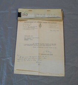
... letter from a Mr. L. Gibney of the department of Crown lands... of the department of Crown lands and survey dated 24th July 1972 addressed ...Four books of stubs. Originally the books had 20 right to occupy residence area forms. The stubs record the date of issue, the replacing right No., the fee paid, the receipt no. and a signature. only one of the books has the original form attached, two of the books have handwritten notes attached. One has a typewritten letter from a Mr. L. Gibney of the department of Crown lands and survey dated 24th July 1972 addressed to the district land officer, Bendigo. In the letter Mr. Gibney tells the officer in Bendigo that a pad containing 20 unnumbered residence area right forms D. The dates on the stubs are 17/04/1961, 16/04/1971, 07/09/1972, 08/05/1975land sales, right to occupy, government -
 Bendigo Historical Society Inc.
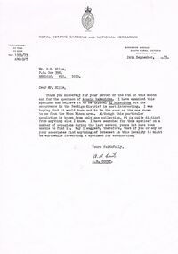
Document - PETER ELLIS COLLECTION: LETTER, 24th September, 1973
... Department of Crown Lands and Survey Victoria... COMMUNICATION Postal letters Peter Ellis Collection Department of Crown ...Letter, dated 24th September, 1973, to Mr P N Ellis from A B Court of the Royal Botanic Gardens and National Herbarium. In the A B Court thanks Mr Ellis for his letter and for the specimen of Acacia hakeoides. He was hoping it would turn out to be the same as the one known to him from the Moon Mines area. He had searched for this species? During the last several years but had been unable to find it. He suggest that if Mr Ellis or his associates find anything of interest in the locality it might be worthwhile forwarding a specimen for examination. Signed A B Court.communication, postal, letters, peter ellis collection, department of crown lands and survey victoria, royal botanic gardens and national herbarium, p n ellis, moon mines area, a b court -
 Bayside Gallery - Bayside City Council Art & Heritage Collection
Map, Department of Crown Lands and Survey et al, Moorabbin, County of Bourke, Government Roads, 1920
... Department of Crown Lands and Survey... Department of Crown Lands and Survey W.J. Butson ...The cadastral map of the Parish of Moorabbin in Victoria (L.6104) shows parish boundaries and land ownership 1920 when Sandringham was a Town. The government roads have been coloured in red pencil.moorabbin, county of bourke, map, plan, land subdivision, land titles, foreshores, hampton, beaumaris, highett, cheltenham, department of lands and survey, land owners, cartographic material, brighton, sandringham, town of sandringham, government roads -
 Bayside Gallery - Bayside City Council Art & Heritage Collection
Photograph, Department of Crown Lands and Survey, Victoria, Melbourne Project: Brighton and Elwood, 1976
... Department of Crown Lands and Survey...The Department of Crown Lands and Survey (1857-1983...Department of Crown Lands and Survey, Victoria... The Department of Crown Lands and Survey (1857-1983) was responsible ...The Department of Crown Lands and Survey (1857-1983) was responsible for the administration of survey and mapping and the sale, occupation and management of crown land throughout its existence. This aerial photograph shows parts of Brighton and Elwood and was taken on 1 December 1976brighton, elwood, department of crown lands and survey, aerial photograph, elsternwick park, point ormond, north road, ormond esplanade, st kilda street, glen huntly road, bayside, port phillip bay, map, cartographic material, melbourne project 1976 -
 Bayside Gallery - Bayside City Council Art & Heritage Collection
Photograph, Department of Crown Lands and Survey, Victoria, Melbourne Project: Brighton, Hampton, Sandringham, 1976
... Department of Crown Lands and Survey...The Department of Crown Lands and Survey (1857-1983...Department of Crown Lands and Survey, Victoria... The Department of Crown Lands and Survey (1857-1983) was responsible ...The Department of Crown Lands and Survey (1857-1983) was responsible for the administration of survey and mapping and the sale, occupation and management of crown land throughout its existence. This aerial photograph shows parts of Brighton, Hampton and Sandringham and was taken on 1 December 1976brighton, department of crown lands and survey, aerial photograph, bayside, port phillip bay, map, cartographic material, hampton, sandringham, green point, sandringham yacht club, south road, beach road, hampton street, melbourne project 1976 -
 Bayside Gallery - Bayside City Council Art & Heritage Collection
Photograph, Department of Crown Lands and Survey, Victoria, Melbourne Project: Brighton, 1976
... Department of Crown Lands and Survey...The Department of Crown Lands and Survey (1857-1983...Department of Crown Lands and Survey, Victoria... The Department of Crown Lands and Survey (1857-1983) was responsible ...The Department of Crown Lands and Survey (1857-1983) was responsible for the administration of survey and mapping and the sale, occupation and management of crown land throughout its existence. This aerial photograph shows parts of Brighton and was taken on 1 December 1976brighton, department of crown lands and survey, aerial photograph, bayside, port phillip bay, map, cartographic material, melbourne project 1976, brighton yacht club, middle brighton baths, north road, st kilda street, new street -
 Bayside Gallery - Bayside City Council Art & Heritage Collection
Photograph, Department of Crown Lands and Survey, Victoria, Melbourne Project: Brighton and Hampton, 1976
... Department of Crown Lands and Survey...The Department of Crown Lands and Survey (1857-1983...Department of Crown Lands and Survey, Victoria... The Department of Crown Lands and Survey (1857-1983) was responsible ...The Department of Crown Lands and Survey (1857-1983) was responsible for the administration of survey and mapping and the sale, occupation and management of crown land throughout its existence. This aerial photograph shows parts of Brighton and Hampton and was taken on 1 December 1976. brighton, department of crown lands and survey, aerial photograph, bayside, port phillip bay, map, cartographic material, melbourne project 1976, brighton yacht club, middle brighton baths, hampton, green point, brighton beach, south road, the esplanade, hampton street -
 Bayside Gallery - Bayside City Council Art & Heritage Collection
Photograph, Department of Crown Lands and Survey, Victoria, Brighton, Elwood and Elsternwick, c. 1965-71
... Department of Crown Lands and Survey...The Department of Crown Lands and Survey (1857-1983...Department of Crown Lands and Survey, Victoria... The Department of Crown Lands and Survey (1857-1983) was responsible ...The Department of Crown Lands and Survey (1857-1983) was responsible for the administration of survey and mapping and the sale, occupation and management of crown land throughout its existence. This aerial photograph shows parts of Brighton, Elwood and Elsternwick and was taken circa 1965-71.brighton, department of crown lands and survey, aerial photograph, bayside, port phillip bay, map, cartographic material, elwood, elsternwick, elsternwick park, elwood tram depot, elwood pier, new street, glen huntly road, st kilda street, nepean highway -
 Bayside Gallery - Bayside City Council Art & Heritage Collection
Photograph, Department of Crown Lands and Survey, Victoria, Brighton, Brighton East and Bentleigh, c. 1965-71
... Department of Crown Lands and Survey...The Department of Crown Lands and Survey (1857-1983...Department of Crown Lands and Survey, Victoria... The Department of Crown Lands and Survey (1857-1983) was responsible ...The Department of Crown Lands and Survey (1857-1983) was responsible for the administration of survey and mapping and the sale, occupation and management of crown land throughout its existence. This aerial photograph shows parts of Brighton, Brighton East and Bentleigh and was taken circa 1965-71.brighton, department of crown lands and survey, aerial photograph, bayside, port phillip bay, map, cartographic material, bentleigh, brighton east, dendy park, dendy street, centre road, nepean highway, south road, football -
 Bayside Gallery - Bayside City Council Art & Heritage Collection
Photograph, Department of Crown Lands and Survey, Victoria, Brighton, Brighton East and Bentleigh, c. 1965-71
... Department of Crown Lands and Survey...The Department of Crown Lands and Survey (1857-1983...Department of Crown Lands and Survey, Victoria... The Department of Crown Lands and Survey (1857-1983) was responsible ...The Department of Crown Lands and Survey (1857-1983) was responsible for the administration of survey and mapping and the sale, occupation and management of crown land throughout its existence. This aerial photograph shows parts of Brighton and Brighton East and was taken circa 1965-71.brighton, department of crown lands and survey, aerial photograph, bayside, port phillip bay, map, cartographic material, brighton east, dendy park, dendy street, centre road, nepean highway, south road, brighton golf course, golf -
 Bayside Gallery - Bayside City Council Art & Heritage Collection
Map, Department of Crown Lands and Survey, Moorabbin, County of Bourke, c. 1918
... Department of Crown Lands and Survey... Department of Lands and Survey Land owners cartographic material ...The cadastral map of the Parish of Moorabbin in Victoria (L.6104) shows parish boundaries and land ownership c. 1918 when Sandringham was a Borough.moorabbin, county of bourke, map, plan, land subdivision, land titles, foreshores, sndringham, hampton, beaumaris, highett, cheltenham, department of lands and survey, land owners, cartographic material, borough of sandringham, brighton -
 Bayside Gallery - Bayside City Council Art & Heritage Collection
Map, Department of Crown Lands and Survey, Melbourne and Suburbs, City of Sandringham, 1917-1926
... Department of Crown Lands and Survey... of Crown Lands and Survey ...map, plan, foreshores, sndringham, hampton, beaumaris, cheltenham, department of lands and survey, cartographic material, borough of sandringham, moorabbin, black rock, street map, city of sandringham -
 Bendigo Historical Society Inc.
Document - NEVILLE KING COLLECTION: OCCUPATION CERTIFICATE HOMESTEAD FARM NO. 15/939 IN THE NAME OF DAVID WILLIAMS AT A COST OF ONE POUND, DATED 25 SEPTEMBER 1897, 1897
Under the Western Australia 'the Homestead act 1893' an Occupation Certificate, Homestead Farm No. 15/939 for David Williams of Bendigo for 160 acres (near Woolkabunning near Bunbury WA); at a cost of one pound. Signed by order of the Commissioner of Crown Lands. Dated 25 September 1897. The land is marked and distinguished in the maps and books of the Department of Lands and Surveys of the said (WA) Colony as Williams Location No. 702. -
 City of Kingston
Photograph - Black and white, 20 December 1945
... of aerial photographs commissioned by the Department of Crown Lands... by the Department of Crown Lands and Survey and taken by Adastra Airways ...Cheltenham is a suburb in the City of Kingston that was originally established as a rural market gardening community. The area is bordered by Highett, Mentone and Heatherton. The market gardens, farms and paddocks have gradually been sub-divided into housing and industrial estates. The Southland shopping centre is a major feature of the area.Cheltenham was established as a rural market gardening community. The Le Page family lived in Cheltenham since 1854 when Nicholas Le Page, a tailor from the Channel Island of Guernsey, bought two acres of land on Chesterville Road near Bernard Street to establish a market garden. Over the years the Le Pages purchased more land in the area. In 1875-76 Nicholas' son Frank and his wife Mary built 'Daphne Cottage' near the corner of Bernard and Wilson Streets. n the 1940s Frank's son, Everest Le Page, bought five more lots of land in Chesterville Road from the Tuck family. The Le Pages grazed horses, ponies and cows on this land, and grew pumpkins, carrots, parsnips, onions, potatoes and cabbages. Many buildings and locations within in Cheltenham commemorate the Le Page family's contribution to the Cheltenham community.Aerial photograph taken in 1945 of the Cheltenham district within the City of Kingston. The image includes Chesterville Road, the future site of Turner Road pool (now Waves) and Highett Reserve, (top left), Jellicoe Street, Argus Street, Bernard Street, Wilson Street, the Methodist Children Homes (now Southland), McIvor Street, Goulburn Street, Nepean Highway, Jamieson Street and Barker Street (bottom left), market gardens and paddocks. In the top centre of the image, "Daphne Cottage", the home of Frank T. Le Page is visible on the corner of Bernard and Wilson Streets. Much of the land depicted in this image was owned by the Le Page family. This image is possibly from the collection of aerial photographs commissioned by the Department of Crown Lands and Survey and taken by Adastra Airways.Black and white ink: 57250 White print: VIC-170 57250 20.12.45 Run 6 PROJ. No. 5 MELB. METROP AREA Black type 10200 FTS 30' LENS 20.12.45cheltenham, market gardens, industry, le page family -
 City of Kingston
Photograph - Black and white, 20 December 1945
... photographs commissioned by the Department of Crown Lands and Survey... commissioned by the Department of Crown Lands and Survey and taken ...This aerial photograph depicts the changing landscape of Cheltenham and Highett since WWII. Photographed in 1945, there is a mix of urban dwellings and industrial development and precedes the major transformation of Cheltenham with the development of the Southland shopping centre in the 1960s and expansion in the 1990s.A large part of Cheltenham was originally established as a rural market gardening community. The railway line and station brought urban development to the area and in the north, the Highett area was dominated by the Highett Gas Works. Cheltenham became a major destination for shopping in the 1960s with the opening of Southland.Aerial photograph taken in 1945 of Cheltenham and Highett within the City of Kingston. The image includes the Highett Reserve, (top right), the Methodist Children Homes (now Southland), Nepean Highway and Jamieson Street. Highett Gas Works is visible in the top left and the land now named William Fry Reserve at the intersection of Bay Road and Nepean Highway. A visible large parcel of land on the corner of Bay Road and Nepean Highway was developed in the 1990s as the west side addition to Southland. The densely vegetated area in the upper right sector of the image is now dense with housing. Tulip Grove, Heather Grove and Gilford Street are visible bottom left. This image is possibly from the collection of aerial photographs commissioned by the Department of Crown Lands and Survey and taken by Adastra Airways.Black ink: 57252 White lettering: VIC-10 57252 20.12.45 [lens information indecipherable] PROJ. No.5 MELB. METROP AREA Black pencil: 80highett, cheltenham, highett gas works, urbanisation -
 City of Kingston
Photograph - Black and white, 20 December 1945
... photographs commissioned by the Department of Crown Lands and Survey... photographs commissioned by the Department of Crown Lands and Survey ...This aerial photograph depicts the changing landscape of Cheltenham and Highett since WWII. Photographed in 1945, there is a mix of urban dwellings and industrial development and precedes the major transformation of Cheltenham with the development of the Southland shopping centre in the 1960s and expansion in the 1990s.A large part of Cheltenham was originally established as a rural market gardening community. The railway line and station brought urban development to the area and in the north, the Highett area was dominated by the Highett Gas Works. Cheltenham became a major destination for shopping in the 1960s with the opening of Southland.Aerial photograph taken in 1945 of Cheltenham and Highett within the City of Kingston. The image includes the Highett Reserve, (top right), the Methodist Children Homes (now Southland), Nepean Highway and Jamieson Street. Highett Gas Works is visible in the top left and the land now named William Fry Reserve at the intersection of Bay Road and Nepean Highway. A visible large parcel of land on the corner of Bay Road and Nepean Highway was developed in the 1990s as the west side addition to Southland. The densely vegetated area in the upper right sector of the image is now dense with housing. Tulip Grove, Heather Grove and Gilford Street are visible bottom left. This image is possibly from the collection of aerial photographs commissioned by the Department of Crown Lands and Survey and taken by Adastra Airways.Black type: Reverse lettering VIC-10 57252 20.12.45 [lens information indecipherable] PROJ. No.5 MELB. METROP AREA White lettering: Reverse writing 57252cheltenham, highett, highett gas works, urbanisation -
 Federation University Historical Collection
Map - Geological Survey, J. Phillips, Geological Survey of Victoria - Ballarat, 1857, 10/1858
... Department of Crown Lands and Survey, Melbourne..., 1857 Map Geological Survey J. Phillips Department of Crown ...Geological map of the Ballarat District featuring four colours.ballarat, geological, geology, geological plan, main road, camp, golden point, pennyweight hill, clayton hill, ballaarat cemetery, bakery hill, specimen hill, soldiers hill, nightingale lead, native youth black hill flat, white flat, mining, mines, eureka lead, old post office hill -
 Eltham District Historical Society Inc
Document - Map, Victoria. Department of Crown Lands and Survey, Town of Eltham, Parish of Nillumbik, County of Evelyn, 2 October 1929
... Victoria. Department of Crown Lands and Survey.... Department of Crown Lands and Survey ...Township of Eltham, Parish of Nillumbik, County of Evelyn / lithographed at the Department of Lands & Survey Melbourne 5th June 1888, amended 2 October 1929 This amendment from the 1888 original shows the reserve for the the State School marked as permanent with dimensions added to Main Road and block frontages along Main Road between Mount Pleasant Road and Dalton Street and Metery Road Possibly photocopied from a copy held at PROV by Harry Gilham whilst resaerching Eltham Primary School history in 1995.a. armstrong, a. lavard, arthur c. allan, arthur c. allen, b. bowatere, baxter street, benjamin oliver wallis, bolton steet, c. souter, c.s. hain, cemetery reserve, charles brown, charles newman, charles symons wingrove, christopher caldwell, church of england, d. anderson, dalton street, david ballard, e. james, e.m. peck, edward dumaresq, eltham town, ely street, f.e. falkiner, f.m. peck, falkiner street, flint street, g. buckingham, g. drabble, george stebbing, godalmin street, h. peck, h.c.whess, h.h. farquharson, h.j. bews, henry stooke, j. goer, j. mcdonald, j. mclaren, j. roberts, j.b. knagers, james irish, jane bailey (nee matthews), john l. smith, john mason, john scott, john smith, joseph stevenson, joseph verse, k. wingrove, k.e. dunstan, kerby street, kirby street, location tbd, m. coman, map, michael o'shea, o.b. mccutcheon, p. & g. tumbull, p.k. mccaughan, p.p. cotter, porter street, pound reserve, robert hepburn, roman catholic church, s. evans, samuel dagley, samuel phillips, samuel ramsden, t. upton, t. watkins, t.a. stark, t.c.b. batt, t.p. cross, thomas grant, thornton street, w. adam, w. blain, w. long, w. watkins, w.f. ford, w.h. hull, w.r. belcher, w.t. schultz, william thomas, eltham primary school, eltham state school, eltham state school no. 209, quarry reserve -
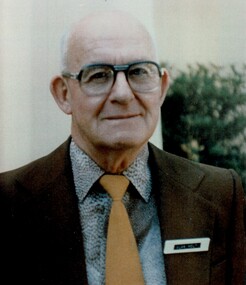 Surrey Hills Historical Society Collection
Photograph, Alan Holt
... in the Department of Crown Lands and Survey. In the 1950s-60s he moved... in the Department of Crown Lands and Survey. In the 1950s-60s he moved ...Alan Holt was keenly interested in the history of Surrey Hills. He worked in the Lands Department and drew up maps of the area based on research he conducted there in his spare time and after retirement. He also compiled a survey of owners / occupants of all Surrey Hills listings from Sands & MacDougall directories at 10 year intervals. These are meticulously entered into hand-written ledgers. All his work is also entered on to index cards. With a lifetime's knowledge of local history and research techniques, Alan found himself after retirement, in constant demand as an amateur historian working for the Box Hill Historical Society and the History Group of the Surrey Hills Neighbourhood Centre. When the Surrey Hills Historical Society was formed, Alan and Edna became its first and only Life Members. Alan began work in the Department of Crown Lands and Survey. In the 1950s-60s he moved to the Premier's Department where he assisted with the planning for the Queen's 1954 visit. He was promoted to Permanent Head of the Lands Department until retirement in 1972. He was associated with the Surrey Hills Uniting Church all his life. There is a copy of this photo in a brass frame.A colour portrait photo of the late Alan Holt.alan holt