Showing 1713 items
matching feet
-
 Federation University Historical Collection
Plan, Ballarat Gaol Sewerage Plan (photocopy), 05/1927
The site of the former Ballarat gaol is now part of Federation University's SMB campus.A3 plan with 6 additional works added to original plan. The last addition was 22 August 1947. WGS 84 37 degrees 33 feet 58 inches S 143 degrees 51 feet 24 inches Eballarat gaol, arthur lasser, gaol, ballarat school of mines, buildings -
 Bendigo Historical Society Inc.
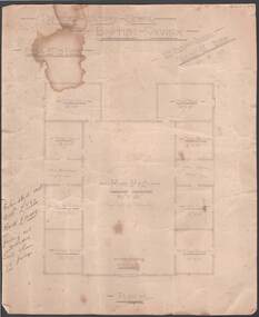
Document - BEEBE, BAPTIST CHURCH DRAWING
Parchment paper architect drawing by William Beebe. Printed heading, 'Proposed Sunday School, Baptist Church', dated 21/9/ 05. Scale 8 feet to Inch. Eight rooms surrounding 30 feet x 50 feet main hall lighted by clearstory. Handwritten cost estimated if weatherboard £850, brick £1040, fencing not included. Land & house 72-foot frontage. Unknown donorbendigo, churches, baptist, beebe -
 Victorian Interpretive Projects Inc.
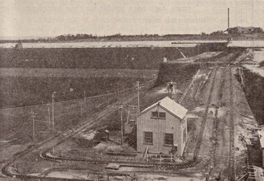
Image, Yallourn, 1934
The coal from this open-cut mine is used to generate electricity for the State of Victoria. in 1934 two thousand miles of high tension transmission lines conveyed energy from a system of inter-linked power stations to the whole Melbourne metropolitan area, as well as to nearly 170 rural centres. Black and white image of the western end of the Yallourn open-cut in 1934. the bucket dredge on surface is reaching down 90 feet, on which level there is another similar dredge going down another 90 feet to the bottom of the 180 foot seam.yallourn, electricty, power, coal, open-cut, dredge -
![Straus’ Falls, Cape Otway Ranges / [by] Nicholas Caire, circa 1876](/media/collectors/550653872162f11fb04854aa/items/57833e2ad0cdd1176c6791eb/item-media/57833ea7d0cdd1176c67b9d8/item-fit-380x285.jpg) Kew Historical Society Inc
Kew Historical Society IncPhotograph, Anglo-Australasian Photographic Company, Straus’ Falls, Cape Otway Ranges, c. 1876
Nicholas Caire was born on Guernsey in the Channel Islands in 1837. He arrived in Adelaide with his parents in about 1860. In 1867, following photographic journeys in Gippsland, he opened a studio in Adelaide. From 1870 to 1876 he lived and worked in Talbot in Central Victoria. In 1876 he purchased T. F. Chuck's studios in the Royal Arcade Melbourne. In 1885, following the introduction of dry plate photography, he began a series of landscape series, which were commercially successful. As a photographer, he travelled extensively through Victoria, photographing places few of his contemporaries had previously seen. He died in 1918. Reference: Jack Cato, 'Caire, Nicholas John (1837–1918)', Australian Dictionary of Biography.An original, rare photograph from the series 'Views of Victoria: General Series' by the photographer, Nicholas Caire (1837-1918). The 60 photographs that comprise the series were issued c. 1876 and reinforced a neo-Romantic view of the Australian landscape to which a growing nationalist movement would respond. Nicholas Caire was active as a photographer in Australia from 1858 until his death in 1918. His vision of the Australian bush and pioneer life had a counterpart in the works of Henry Lawson and other nationalist poets, authors and painters.‘Straus’ Falls, Cape Otway Ranges’ : Views of Victoria (General Series) No.55 : Albumen silver photograph | Photo on card with Title and Description on reverse | Mounted 24 x 30 cm; Photo 12 x 17 cm.On Reverse: ‘These Falls were discovered some time since by a gentleman named Straus, and were so named in memory of him. They comprise a succession of falls, rapids, and cataracts varying from 10 feet to 60 feet, making a total of 250 feet from the fall to the bed of the stream. These waters probably form a tributary to one of the adjacent rivers.’nicholas caire (1837-1918), landscape photography -
 Phillip Island and District Historical Society Inc.
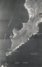
Photograph, R.A.A.F, 1939
One of a collection of over 400 photographs in an album commenced in 1960 and presented to the Phillip Island & Westernport Historical Society by the Shire of Phillip IslandAerial Photograph of the western end of Phillip Island taken by the RAAF in 1939 from 13,000 feet.local history, photography, aerial photograph of summerland island, black & white photograph, coastline, beaches, the nobbies, john jenner, bryant west -
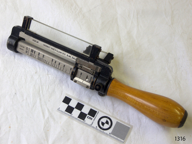
 Fire Services Museum of Victoria
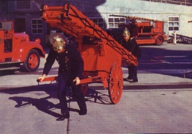
Fire Escape - Wheeled Ladder, Curricle Ladder
Curricle Fire Escape Ladder hand or horse drawn 3 stage 60 feet extension -
 Flagstaff Hill Maritime Museum and Village
Tool - Wood Mitre & Trimmer Guillotine, Early 20th century
The mitre trimmer is a classic hand-powered tool for picture framers and trim carpenters that has remained relatively unchanged for decades. It is heavy, simple, and sturdily built of cast iron with tempered steel guillotine blades. It is used for taking super accurate, paper-thin slices off the ends of mitres and butt joints, and leaving behind a glassy-smooth surface. Also used in picture frame making or cabinet woodworking, by placing a piece of timber in one side after setting the desired angle and pulling a handle that operates a guillotine blade thereby cutting the timber or decorative trim to the required angle.A significant tool still in use today in many cabinet makers workshops. The subject tool gives insight into how this type of tool development, design and use has not progressed since it’s original invention. It is still for sale from many tool manufacturing companies and use in small craftsmen boutique workshops today as it was many decades ago.Cast Iron wood Trimmer bench like construction on raised feet with 2 adjustable gates. Noneflagstaff hill, warrnambool, shipwrecked-coast, flagstaff-hill, flagstaff-hill-maritime-museum, maritime-museum, shipwreck-coast, flagstaff-hill-maritime-village, cabinet makers tools, picture framing, mitre cutting, wood trimming -
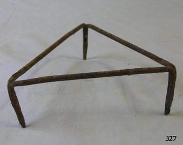 Flagstaff Hill Maritime Museum and Village
Domestic object - Iron stand
Households from the 18th century onwards used a hot iron to removed wrinkles and creases in fabric such as clothing, table and bed linen This simple iron stand provided a rest for a hot iron between use during an ironing session and a place for the iron to cool when the session was completed. This item is associated with domestic life during the 19th and early 20th centuries. Triangular shaped stand made from metal rods welded together at feet. Painted black.flagstaff hill, flagstaff hill maritime museum and village, warrnambool, maritime museum, maritime village, great ocean road, shipwreck coast, iron stand, triangular iron stand, ironing, laundry equipment -
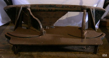
 Federation University Historical Collection
Scientific Instument, J.L. William Instruments, Galvonometer
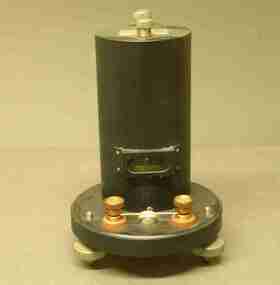
A ballistic galvonometer in black sealed metal enclosure, of cylindrical shape on a circular base, with levelling feet. scientific instrument, galvonometer, ballistic galvanometer -
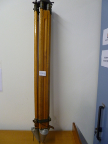 National Vietnam Veterans Museum (NVVM)
Functional Object, Tellurometer Tripod, 1958
Three legged timber adjustable tripod with metal conical feet and metal tellurometer base fitmentEngraved number - 150517 on legs, Adhesive label with "Australian Survey Office" with written number A404 21tripod, tellurometer -
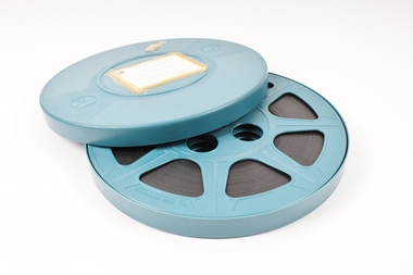 Melbourne Legacy
Film, Legacy, 1964
A black and white film about Legacy camps, made in the 1960s it shows the routine and activities for Junior Legatees at a typical camp weekend. There is an address by the then President Ian Anderson (1964). Commentary Geoff McComas, Photography Garry Jones. This film has been digitised to preserve its content. Melbourne Legacy gratefully acknowledges the support of the Victorian Government and Public Record Office Victoria for making this possible. See also Cat No 00006 which is a second copy of the same film and has been digitised by DamSmart 6/11/2019.Rare footage of activities run by Melbourne Legacy for boys post WWII which indicates how many children Legacy cared for both in Victoria and nationally and shows the dedication of Legatees in providing this care.Blue plastic cover with 800 feet 16mm film inside. Paper classification on cover, taped on.Cover info is as follows: CINE SERVICE PTY, LTD. / Telephone 69 7346 / 235 MORAY STREET, SOUTH MELBOURNE TITLE "LEGACY" PRODUCED FOR MELBOURNE LEGACY COLOUR / BLACK AND WHITE (tick next to box) / RUNNING TIME 20 mins. Blue handwriting reads: Please return to Melbourne (Legacy) 293 Collins St, Melbournesomers camp, junior legatees -
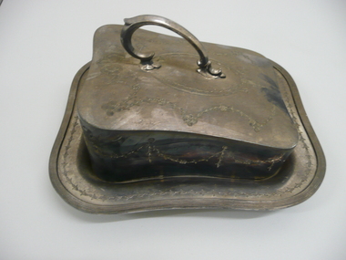 Bendigo Historical Society Inc.
Domestic Object - FAVALORO COLLECTION: CHEESE DISH
EPBM Cheese dish with tray and handle, heavily embossed with floral decoration, 4 ball feet.James Dixon & Sons E.P.B.M PE259 A.Saunders A1 Quality Sydneydomestic equipment, table setting, cheese dish -
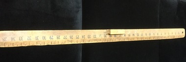 Mont De Lancey
Blackboard ruler
Used by Nancy Adeney when teaching school 1950's.Three feet long wooden blackboard ruler with black divisions and numbers - has a wooden handle.measuring instruments, school equipment -
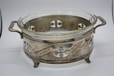 Kyneton Fire Brigade
Memorabilia - Trophy
Awarded for 4 Man Engine Y Coupling Warrnambool 1929Part of Kyneton Fire Brigade trophy collection Heavy clear glass bowl on filigreed silver metal base with two handles and four feetBOWL : 168-268 Upper rim STAND : Warrnambool 1929 4 Man Engine Y Coupling Won by KYNETONkyneton fire brigade, country fire authority, fire brigade demonstrations, trophy -
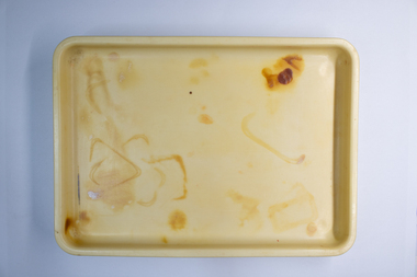 Charlton Golden Grains Museum Inc
Domestic object - Xylonite Moulded Dressing Table Tray
Moulded Xylonite tray with rounded corners. Rounded feet on each corner of base. Part of set. -
Federation University Bookplate Collection
Work on paper - Bookplate, Ex-libris
Monochrome of bespectacled and crowned kangaroo with belly full of books titled Ex-libris at its feet.Initialled in pencil lower right beneath image. -
 Flagstaff Hill Maritime Museum and Village
Rangefinder, E R Watts & Sons, 1930-1945
E. R. Watts and Son, makers of theodolites and other surveying instruments, of 123 Camberwell Road, London. The company was established in 1856 by Edwin Watts at twenty-three he had saved £100 from his earnings to start the business with his staff consisting of one boy and later Alexander Clarkson as an apprentice with the workshop a small room over a Bemondsey stable. Watts' first order was from Negretti and Zambra for a mining dial Alexander Clarkson In the early days the firm worked mainly on marine compasses. Edwin Watts would go down to the Docks to adjust the compasses once they had been installed on the ships. In May 1873 the business moved to larger premises a house with a garden. The workshop was also the home of Mr and Mrs Watts and their five sons and three daughters. By now there were fifteen to twenty men employed by the firm. The company were commissioned to supply the Theodolites and Levels for the construction to the Canadian Pacific Railway in 1881. Towards the end of the century, the firm began to make heliographs continuing to produce them for the government until just before the Second World War when by agreement assigned their manufacture to another firm. 1904 The first dividing engine was completed by George William Watts. It was so remarkable an instrument at the time and for years afterwards, In 1907 Arthur Ames went to Canada and started an organisation in Winnipeg in 1909 this became a separate company called E. R. Watts and Son Ltd. of Ottawa. This firm developed considerably and was eventually with the co-operation of three other instrument companies (Cambridge Instrument Co, Ross, and Negretti and Zambra), were reconstituted as ”Instruments Ltd” of Ottawa and Toronto. During the next ten years, the firm expanded greatly to include glass grinding, leather work, dividing and engraving, testing, adjusting and packing. This expansion was continued during the First World War when workshops were completed and the machinery installed and running within eleven weeks from the start of construction. During the war, a Sergeant Coles, among the rats, lice and mud of the trenches, fitted various bits of scrap into his cocoa tin and made the first Flash Spotter for plotting the positions of enemy guns. Coles was rushed home to the firm's factory where he and George William Watts designed a spotter not made out of a cocoa tin and as a result, the Watts Vertical Force Variometer was developed during WWI. Other Watts instruments made in the First World War included the Light Mountain Theodolites which were taken on Mt Everest expeditions. In 1919 ER Watts and Sons was incorporated as a limited company and in 1939 G. A. Whipple joined the Board of Directors. Shortly afterwards, Frank Charles Watts died having been Chairman of the firm for over 37 years and seen it through the First World War with all its expansions and difficulties. He was succeeded by his brother George William Watts with the vacant post of Managing Director being filled by G. A. Whipple. During the Second World War, the company expanded further and the number of employees rose to well over 1,300. In 1946 Watts acquired 78% of Adam Hilger and the microscope maker James Swift and Son Who were Manufacturers of Theodolites, Levels, Alidades, Meteorological Instruments, Variometers, and many other types of scientific instruments Then in 1948 the company amalgamated with Adam Hilger as Hilger and Watts which was then incorporated as a public company.Naval Rangefinder with a vertical wooden handle, and an arrangement of optical lenses. Three reversible brass inserts calibrated on both sides in yards, correspond to various base heights, (20 and 25 feet, 30 and 35 feet and 40 and 50 feet). They are fitted along the axis of the instrument. When the scale for the appropriate base height is selected and inserted, the carriage can be slid for coincidence and the distance read at the index mark on the sliding carriage.inscribed "Rangefinder Cotton Type Mk II" Calibrated scale up to 5000 yds (50 ft), 5000 yds (35 ft), 4000 yds (25 ft) made by E. R. Watts & Son.flagstaff hill, warrnambool, shipwrecked coast, flagstaff hill maritime museum, maritime museum, shipwreck coast, flagstaff hill maritime village, great ocean road, rangefinder, cotton type, e r watts & sons, naval range finder, marine equipment -
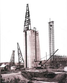 Wodonga & District Historical Society Inc
Album - Hume Reservoir Australia Album - Concrete pillar for tall tower, New South Wales, August 1927
This set of photos is from a leather bound album bearing the inscription "HUME RESERVOIR AUSTRALIA" plus 'The Rt. Hon. L. C. M. S. Amery, P. C., M .P.' all inscribed in gold. It was presented to The Rt. Hon. L. C. M. S. Amery, P. C., M. P, Secretary of State for Dominion Affairs on the occasion of his visit to the Hume Reservoir on 2nd November 1927. This album is of local and national significance as it documents the planning and development of the Hume Reservoir up to 1927. It was the largest water reservoir in the British Empire. The album records the pioneering engineering work that went into its construction.DEPARTMENT OF PUBLIC WORKS, N.S.W. RIVER MURRAY WATERS SCHEME. HUME RESERVOIR. 28. Concrete Pillar for Tail Tower. This shows the back and upstream side of the tower. The groove at the back is left for the reception of the concrete core wall of the earth embankment. The groove is being used at present as a hoist well, up and down which men and materials are conveyed in connection with the re-erection of the Tail Tower of the cableway. The pillar is 108 feet from the ground and is within 4 feet of its ultimate height. The foundation of this part at its deepest is 90 feet below the natural surface so that when the 80 feet tower and jury mast are in place the total height from foundation to top of mast will be about 300 feet. New South Wales, August 1927.hume reservoir australia, river murray waters scheme, hume reservoir construction -
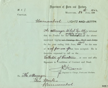 Flagstaff Hill Maritime Museum and Village
Document - Ports and Harbours, Ports and Harbours, Tender for Warrnambool Light, 24-06-1902
The document confirms that the Tender for the supply of gas to the Warrnambool Light, also known as the Lighthouse, by the Warrnambool Gas Works was successful. The Tender was issued by the Engineer in Charge, Ports and Harbours, Melbourne, for a the period ending 30th June 1903, at the offered rate of 10/- (ten shillings) per 100.0 c/f (cubic feet). The Manager of the Warrnambool Gas Works expected to follow this acceptance with a visit to the Collector of Customs to sign the Conditions of Contract and Bond. The light of Warrnambool's Lady Bay Lighthouse was originally powered by oil. Later it was converted to gas, followed by electricity, then solar power, and finally to battery power. The Warrnambool Gas Company operated the gas works from the 1870's to the late 1920's.This document connects Warrnambool's Lady Bay Lighthouse to the Warrnambool Gas Works during the first decade of the 20th century. It documents to process of a Government department requesting Tenders for the supply of goods to operate a service, the the formal documentation required at that time.Pale green rectangular paper with template text printed in black and completed in black ink script. Letterhead of the Department of Ports and Harbours, Melbourne, and addressed to the Gas Works, Warrnambool, dated 24th June 1902, for the supply of gas to the Warrnambool Light until 30th June 1903 at the cost of Ten Shillings per 100 cubic feet."24th [June] 1902" Warrnambool [Light]" "Manager W'bool Gas Wks" "supply of gas to" "1903" "10/- per 100.0 c/f" "Collector of Customs" " The Manager / Gas Works / Warrnambool" [Signature] "for" [Engineer in Charge, Ports and Harbours]flagstaff hill, flagstaff hill maritime museum and village, warrnambool, maritime museum, maritime village, great ocean road, shipwreck coast, department of ports and harbours, ports and harbours, ports and harbours melbourne, warrnambool light, warrnambool lighthouse, warrnambool gas works, w'bool gas works, gas works, gas supply, early 1900s, early 20th century, shillings, cubic feet, collector of customs, customs, warrnambool customs, engineer in charge, lady bay lighthouse, warrnambool gas company -
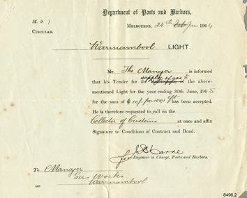 Flagstaff Hill Maritime Museum and Village
Document - Ports and Harbours, Ports and Harbours, Tender for Warrnambool Light, 24-06-1904
The document confirms that the Tender for the supply of gas to the Warrnambool Light, also known as the Lighthouse, by the Warrnambool Gas Works was successful. The Tender was issued by the Engineer in Charge, Ports and Harbours, Melbourne, for a the period ending 30th June 1905, at the offered rate of 10/- (ten shillings) per 100.0 c/f (cubic feet). The Manager of the Warrnambool Gas Works expected to follow this acceptance with a visit to the Collector of Customs to sign the Conditions of Contract and Bond. The light of Warrnambool's Lady Bay Lighthouse was originally powered by oil. Later it was converted to gas, followed by electricity, then solar power, and finally to battery power. The Warrnambool Gas Company operated the gas works from the 1870's to the late 1920's.This document connects Warrnambool's Lady Bay Lighthouse to the Warrnambool Gas Works during the first decade of the 20th century. It documents to process of a Government department requesting Tenders for the supply of goods to operate a service, the the formal documentation required at that time.Pale cream rectangular paper with template text printed in black and completed in black ink script. Letterhead of the Department of Ports and Harbours, Melbourne, and addressed to the Gas Works, Warrnambool, dated 24th June 1904, for the supply of gas to the Warrnambool Light until 30th June 1905 at the cost of Ten Shillings per 100 cubic feet."24th [June] 1904" Warrnambool [Light]" "Manager W'bool Gas Wks" "supply of gas to" "1905" "10/- per 100.0 c/f" "Collector of Customs" " The Manager / Gas Works / Warrnambool" [Signature] "for" [Engineer in Charge, Ports and Harbours]flagstaff hill, flagstaff hill maritime museum and village, warrnambool, maritime museum, maritime village, great ocean road, shipwreck coast, department of ports and harbours, ports and harbours, ports and harbours melbourne, warrnambool light, warrnambool lighthouse, warrnambool gas works, w'bool gas works, gas works, gas supply, early 1900s, early 20th century, shillings, cubic feet, collector of customs, customs, warrnambool customs, engineer in charge, lady bay lighthouse, warrnambool gas company -
 Wodonga & District Historical Society Inc
Album - Hume Reservoir Australia Album - Detail plan and explanation, Department of Public Works, N.S.W, 1927
This set of photos is from a leather bound album bearing the inscription "HUME RESERVOIR AUSTRALIA" plus 'The Rt. Hon. L. C. M. S. Amery, P. C., M .P.' all inscribed in gold. It was presented to The Rt. Hon. L. C. M. S. Amery, P. C., M. P, Secretary of State for Dominion Affairs on the occasion of his visit to the Hume Reservoir on 2nd November 1927. This album is of local and national significance as it documents the planning and development of the Hume Reservoir up to 1927. It was the largest water reservoir in the British Empire. The album records the pioneering engineering work that went into its construction.2. Detail Plan and Section. Starting from the New South Wales and there will be an earthen embankment 430 feet 6 inches long which is retained by the North Wing Wall. Then come the sluice section 284 feet 3 inches long, the spillway 720 feet long and the South Wing Wall, making a total length of 1,042 feet 6 inches of concrete wall. Beyond the South Wing Wall is earth embankment again to a length of 3,827 feet. The Full Supply Level is R.L.626.00 and allowance has been made for a surcharge of 9 feet. A road will run along the top of the dam at R.L.642.00. The sluice section contains seven offlets, the three nearest the north wing wall being 13 feet in diameter for hydro-electric purposes and the other four 9 feet in diameter for regulation purposes only. There are to be stony sluice gates on the upstream ends of the outlets and needle valves on the downstream ends. The shock of the discharged water will be taken by a stilling pool. Trash racks will protect the intake ends of the outlets. Next comes the spillway section, which is curved on the downstream face, and carried up to within 15 feet of the full supply level. Above that will be a series of piers between which will be the flood gates and on top of which the roadway will be carried. The gates will be 20 feet wide and 15 feet high and will be 29 in number. They will slide down the face of the wall when opened for the escape of the water. The investigation of the control of this cascade of water was made by means of a model and as a result the form of “bucket” or energy dissipater shown on the section of the spillway was decided upon. The earth embankment in Victoria is being constructed by the State Rivers and Water Supply Commission of Victoria who are the Constructing Authority for that State under the River Murray Waters Agreement. The core of the embankment is of concrete 6 feet wide at the base tapering to 2 feet at the top end and is reinforced with steel rods from the level of the decomposed rock upwards. On the downstream side, at about natural surface level, is a tunnel for drainage and inspection purposes. Above the tunnel is a vertical layer of large stones to drain any seepage to the tunnel. Against the core wall is packed selected material of as impervious a character as can be got locally and beyond that the bank is carefully built up in horizontal layers by means of horses and wheel scoops. The upstream slope is 3-to-1 hardening to 2½-to-1 at the top and the downstream slope is 2½-to-1 hardening to 2.07-to-1 at the top. The thrust of the upstream toe is taken by a mass of granite blocks, and this face is protected by concrete laid in situ. The width of the bank at base is 650 feet and at top 32 feet.hume reservoir australia, river murray waters scheme, hume weir diagrams, hume plan details -
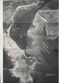 Phillip Island and District Historical Society Inc.
Photograph, R.A.A.F, 1939
One of a collection of over 400 photographs in an album commenced in 1960 and presented to the Phillip Island & Westernport Historical Society by the Shire of Phillip IslandAerial Photograph of eastern end of Phillip Island and the Eastern Passage taken by the RAAF in 1939 at 13,000 feet.local history, photography, aerial photograph, eastern passage, cape woolamai, black & white photograph, coastline, r.a.a.f., john jenner, bryant west -
 Greensborough Historical Society
Map, Municipality of Heidelberg Plan No. 480, 17/10/1948
Map shows streets, buildings, river and major drainage easements in area covered by West boundary Sellars Street, North boundary Yando Street & South boundary Grimshaw Street. Adjoins Map No. 481 to East. Black & white map, features marked in green, gradients in red. Scale: 160 feet to 1 inchgreensborough -
4th/19th Prince of Wales's Light Horse Regiment Unit History Room
Aerial Photograph, British Army, Mericourt, 31/7/18
An aeriall photograph taken from 5000 feet looking towards Mericourt from behind the British front. Marked on the photo is the approximate British front line as at 31-7-18, and, locations such as Chuignolles, St Germain Wood, Mericourt, Prayart, Somme, Cerisy. 3.B.S.48 Ht 5000 ftsomme, ww1, photo -
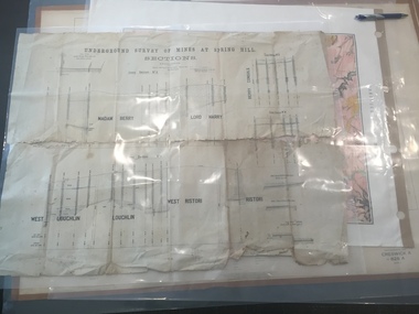 Federation University Historical Collection
Plan, Underground Survey of Mines at Spring Hill - Sections
This plan is associated with former Ballarat School of Mines Student Richard Squire (1875-1876). Printed (in black ink) sections of underground mines on cream paper. 120 feet to one inch scale.Numbers written in pencil along bottom of plan. madam berry, lord harry, berry consols, west loughlin, loughlin, west ristori, ristori, mining, gold mining, gold, underground survey -
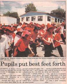 Ringwood and District Historical Society
Newspaper, Scrapbook Clipping, Library Collection, Ringwood, Victoria
Newspaper Clipping from the ""Mail", 2-12-1997 P16. "Pupils put best feet forth"Pupils at Mullum Primary School took part in a Walkathon to raise money for their new hall. The school's 326 pupils walked about 2750 kilometres on a fund raising walkathon . Principal Rob Bloye said the event raised about $5000 for the new hall's heating and carpet. Mr Bloye said the $90,000 school hall would be finished by the start of the next school year. "The hall is a co-operative project, which means it has been fundfed by the community without any government grants", he said. -
Clunes Museum
Map - MAPS/DOCUMENTS
INFORMATIONDOCUMENTATION AND MAPS DESCRIBING THE WORKINGS OF THE PORT PHILLIP MINE, SHOWING 54 FEET DEEP OF THE UNDERGROUND WORKINGS.local history, mining, port phillip mine -
Whitehorse Historical Society Inc.
Map, Mitcham Road, c1970
Enlarged aerial photograph of intersection of Whitehorse and Mitcham Roads, Mitcham. Scale 1 inch : 40 feetEnlarged aerial photograph of intersection of Whitehorse and Mitcham Roads, Mitcham. Scale 1 inch : 40 feetEnlarged aerial photograph of intersection of Whitehorse and Mitcham Roads, Mitcham. Scale 1 inch : 40 feetmitcham road, mitcham, maroondah highway, mitcham, whitehorse road, mitcham, mitcham primary school, no. 2904, mitcham hotel, aerial photographs -
Whitehorse Historical Society Inc.
Map, Proposed Smoke-House Schwerkolt Cottage, 11/07/1975 12:00:00 AM
Plans of proposed Smoke-house for Schwerkolt Cottage drawn by the City of Nunawading. Scale 10 feet to anPlans of proposed Smoke-house for Schwerkolt Cottage drawn by the City of Nunawading. Scale 10 feet to an inch.Plans of proposed Smoke-house for Schwerkolt Cottage drawn by the City of Nunawading. Scale 10 feet to an smoke houses, schwerkolt cottage & museum complex -
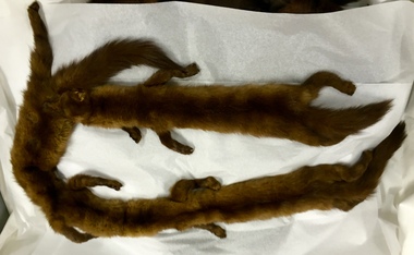 Kew Historical Society Inc
Clothing - Fur Stole, Three Full Body Sable Stole, 1930-1955
Narrow brown fur wrap comprised of three separate sable pelts including heads, feet and tailsfurs, costume accessories, stoles