Showing 353 items matching "land settlement"
-
 Phillip Island and District Historical Society Inc.
Photograph Album, Kodak, Phillip Island Cemetery, c 1990
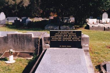
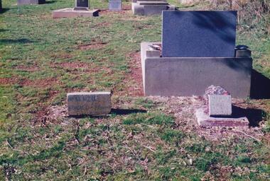
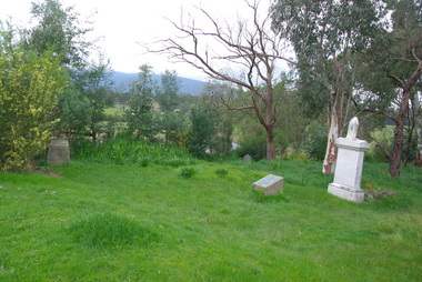
... aside as Crown Land in the land settlement of 1868... Land in the land settlement of 1868. There are 6.2 acres ...The Album was compiled by Nancy McHaffie late 1990's, with the assistance of Edith Jeffery's, with her book "Garden of Memories" and extensive knowledge of Phillip Island. The Cemetery lies back from the road and is surrounded by Manna Gums, rare Peppermint Gums, Blackwoods and other native trees. In all 25 acres of land were set aside as Crown Land in the land settlement of 1868. There are 6.2 acres of wetlands near the cemetery entrance.Stanley Joseph McFee; Stanley was born at Auburn Grove, Auburn on the 23rd January 1892. He was the seventh son of William and Annie McFee. The McFee family moved to Rhyll in 1894 where Stanley was educated at the Rhyll School. Later he took up farming at Long Point, now known as McFees Road. In 1917 Stanley married Isabell May Cherry who came to Rhyll in 1912 as the school teacher. His wife May supported him in his community activities. Stanley died 1980 aged 88. Isabell May died 1966 aged 78. phillip island cemetery, stanley mcfee, isabell mcfee, nancy mchaffie, edith jeffery -
 Phillip Island and District Historical Society Inc.
Photograph Album, Kodak, Phillip Island Cemetery, c 1889
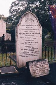
... aside as Crown Land in the land settlement of 1868... Land in the land settlement of 1868. There are 6.2 acres ...The Album was compiled by Nancy McHaffie late 1990's, with the assistance of Edith Jeffery's, with her book "Garden of Memories" and extensive knowledge of Phillip Island. The Cemetery lies back from the road and is surrounded by Manna Gums, rare Peppermint Gums, Blackwoods and other native trees. In all 25 acres of land were set aside as Crown Land in the land settlement of 1868. There are 6.2 acres of wetlands near the cemetery entrance.Captain McLeod: Captain McLeod and family kept the Post Office at Newhaven. He also built a boat called old "Trusty" and launched it almost opposite Churchill Island. Unfortunately, at a later date, the "Trusty" was the cause of a tragedy. The bottom of the boat had become so encrusted with marine growth that the owner decided to beach her between the jetties at Griffiths point, now San Remo. Before the job was completed the soring gave way and allowed the boat to tip over on her side, causing Captain McLeod to be crushed to death. Died March 3rd 1880 aged 64 years. Also buried in this grave is his wife Susan - died May 24th 1882 aged 62 years. Their son Andrew McLeod died February 21st 1916 aged 60 - loved husband of Elizabeth E McLeod. Alexander was Captain of the "Genista" for 12 years.phillip island cemetery, captain alexander mcleod, susan mcleod, andrew mcleod, nancy mchaffie, edith jeffery -
 Phillip Island and District Historical Society Inc.
Photograph Album, Kodak, Phillip Island Cemetery, c 1990
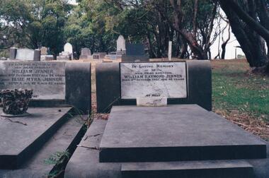
... aside as Crown Land in the land settlement of 1868... Land in the land settlement of 1868. There are 6.2 acres ...The Album was compiled by Nancy McHaffie late 1990's, with the assistance of Edith Jeffery's, with her book "Garden of Memories" and extensive knowledge of Phillip Island. The Cemetery lies back from the road and is surrounded by Manna Gums, rare Peppermint Gums, Blackwoods and other native trees. In all 25 acres of land were set aside as Crown Land in the land settlement of 1868. There are 6.2 acres of wetlands near the cemetery entrance.Two photos: a) Two graves - William Jenner & Elsie Myra Jenner. William died Oct 1957 aged 73 and Elsie died April 1968 aged 82. - William Raymond Jenner - son of William & Elsie - died Oct 1951 aged 42 years. b) Close up of William & Elsie grave. William had a farm at Ventnor, grew onions and chicory and was always willing to help out or lend any farming machinery. William was a member of the Ventnor School committee and Ventnor Hall committee. He was married to Elsie Churchill of Kilcunda and they had five children.phillip island cemetery, william jenner, elsie jenner, nancy mchaffie, edith jeffery -
 Phillip Island and District Historical Society Inc.
Photograph Album, Kodak, Phillip Island Cemetery, c 1990
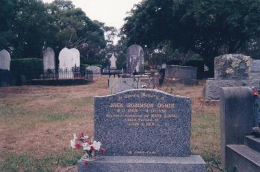
... aside as Crown Land in the land settlement of 1868... Land in the land settlement of 1868. There are 6.2 acres ...The Album was compiled by Nancy McHaffie late 1990's, with the assistance of Edith Jeffery's, with her book "Garden of Memories" and extensive knowledge of Phillip Island. The Cemetery lies back from the road and is surrounded by Manna Gums, rare Peppermint Gums, Blackwoods and other native trees. In all 25 acres of land were set aside as Crown Land in the land settlement of 1868. There are 6.2 acres of wetlands near the cemetery entrance.Jack Robinson Oswin: Many of the trees now flourishing in the cemetery grounds were planted by Jack Oswin and his wife Coral. Born in Mildura in 1909, his association with Phillip Island started when he attended the Cowes Primary School during the war years. He was foundation member of the Phillip Island Conservation Society and played a key role in the purchases of the area of land known as Conservation Hill. In the early 1980s he was awarded the British Empire Medal in recognition for his services to conservation. Jack died on December 4th 1990, aged 81 years.phillip island cemetery, jack robinson oswin, coral oswin, nancy mchaffie, edith jeffery -
 Phillip Island and District Historical Society Inc.
Photograph Album, Kodak, Phillip Island Cemetery, c 1990
... aside as Crown Land in the land settlement of 1868... Land in the land settlement of 1868. There are 6.2 acres ...The Album was compiled by Nancy McHaffie late 1990's, with the assistance of Edith Jeffery's, with her book "Garden of Memories" and extensive knowledge of Phillip Island. The Cemetery lies back from the road and is surrounded by Manna Gums, rare Peppermint Gums, Blackwoods and other native trees. In all 25 acres of land were set aside as Crown Land in the land settlement of 1868. There are 6.2 acres of wetlands near the cemetery entrance.The McKenzie Children: Late one night in 1934, Mr Bryant West and Mr Loton heard cries for help from the vicinity of the Cowes Jetty. Attempts were made to save a woman and the children. Sadly only the adult could be rescued. The three young bodies were later recovered and buried in the cemetery. Parents: Ronald & Ena McKenzie - Children: Ronald aged 5 years, Ena Roma aged 4 years and Douglas Forbes aged 1 year. phillip island cemetery, the mckenzie children, nancy mchaffie, edith jeffery -
 Phillip Island and District Historical Society Inc.
Photograph Album, Kodak, Phillip Island Cemetery, c 1990
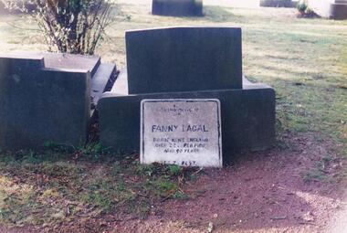
... aside as Crown Land in the land settlement of 1868... Land in the land settlement of 1868. There are 6.2 acres ...The Album was compiled by Nancy McHaffie late 1990's, with the assistance of Edith Jeffery's, with her book "Garden of Memories" and extensive knowledge of Phillip Island. The Cemetery lies back from the road and is surrounded by Manna Gums, rare Peppermint Gums, Blackwoods and other native trees. In all 25 acres of land were set aside as Crown Land in the land settlement of 1868. There are 6.2 acres of wetlands near the cemetery entrance.FANNY LAGAL (nee THOMPSON): Fanny arrived in Australia in the early 1920s. After her husband died she arrived on Phillip Island. She worked at "Summerland House" and later at the "Isle of Wight Hotel". She took great pride in keeping the altar linen and generally looking after the Anglican Church. Those who knew her said she was a gracious lady with a great sense of humour. Fanny went to a nursing home at Frankston where she resided until she died in February 1980, aged 90. Friends arranged for her to be buried at the Cemetery.phillip island cemetery, fanny lagal nee thompson, nancy mchaffie, edith jeffery -
 Phillip Island and District Historical Society Inc.
Photograph Album, Kodak, Phillip Island Cemetery, c 1990
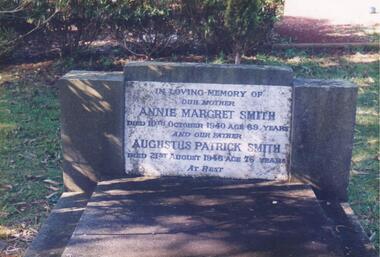
... aside as Crown Land in the land settlement of 1868... Land in the land settlement of 1868. There are 6.2 acres ...The Album was compiled by Nancy McHaffie late 1990's, with the assistance of Edith Jeffery's, with her book "Garden of Memories" and extensive knowledge of Phillip Island. The Cemetery lies back from the road and is surrounded by Manna Gums, rare Peppermint Gums, Blackwoods and other native trees. In all 25 acres of land were set aside as Crown Land in the land settlement of 1868. There are 6.2 acres of wetlands near the cemetery entrance.466-54: Annie Margaret Smith (nee Kearns) and Augustus Patrick Smith. Annie died in 1940 aged 69 years and was the wife of Augustus who died 1946 aged 76 years. He was the son of George Smith who arrived on Phillip Island about 1869. He paid 20 shillings per acre for 175 acres. 466-55: Margaret Jean Mallory. Margaret arrived on the Island in 1929 to teach at the Ventnor School. She became interested in community affairs and was the first to start the Girl Guides. She was President of the CWA and foundation member of the Golf Club. Margaret with her husband William (Bill), were tireless workers for the Children's Hospital along with many other worthy causes. Margaret died on November 25th, 1982 aged 75. William died February 1989 aged 87.phillip island cemetery, annie margaret smith nee kearns, augustus patrick smith, george smith, margaret jean mallory, william alfred mallory, nancy mchaffie, edith jeffery -
 Phillip Island and District Historical Society Inc.
Photograph Album, Kodak, Phillip Island Cemetery, c 1990
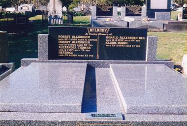
... aside as Crown Land in the land settlement of 1868... Land in the land settlement of 1868. There are 6.2 acres ...The Album was compiled by Nancy McHaffie late 1990's, with the assistance of Edith Jeffery's, with her book "Garden of Memories" and extensive knowledge of Phillip Island. The Cemetery lies back from the road and is surrounded by Manna Gums, rare Peppermint Gums, Blackwoods and other native trees. In all 25 acres of land were set aside as Crown Land in the land settlement of 1868. There are 6.2 acres of wetlands near the cemetery entrance.466-56: Alexander McLardy Sr. The descendants of Alex McLardy came to Phillip Island in the year 1886. A builder by trade, he built a great number of houses and buildings on the Island. He was also the founder of the Guesthouse "Glencoe". At 90 years of age he could still read well without the aid of glasses. He died in 1956 aged 95. Others buried in the double graves are: Robert Alexander died 1926 aged 10 months, Alexander Thomas died 1971 aged 76, Beatrice died 1966 aged 73, Donald Alexander died 1992 aged 64 and Claire Isobel died 1993 aged 61. 466-57: Walter Findlay. Walter's parents George and Mary, came to Australia in 1852. Walter was born in Sale circa 1883. He married Henrieta Kennon and they lived and farmed in Settlement Road, Cowes prior to their shop and residence being built in Warley Avenue, Cowes. The shop carried general merchandise and confectionery. The property was absorbed by Bass Coast Family Medicine on the west side of Warley Avenue. Henrieta died September 1965 aged 84. Walter died July 1965 aged 82.phillip island cemetery, alexander mclardy, walter findlay, nancy mchaffie, edith jeffery -
 Phillip Island and District Historical Society Inc.
Photograph Album, Kodak, Phillip Island Cemetery, c 1990
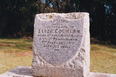
... aside as Crown Land in the land settlement of 1868... aside as Crown Land in the land settlement of 1868 ...The Album was compiled by Nancy McHaffie late 1990's, with the assistance of Edith Jeffery's, with her book "Garden of Memories" and extensive knowledge of Phillip Island. The Cemetery lies back from the road and is surrounded by Manna Gums, rare Peppermint Gums, Blackwoods and other native trees. In all 25 acres of land were set aside as Crown Land in the land settlement of 1868. There are 6.2 acres of wetlands near the cemetery entrance.a) Grave stone of Eliza Coghlan b) Grave stone of Eliza Coghlan with Edith Jeffery standing beside. Eliza was born in West Heath, Ireland. She arrived in Australia on the immigrant ship "Thomas Arbuthnot". She came to Phillip Island as house-keeper to James Duffus and served for 40 years. She was often seen walking to Cowes, about five miles, carrying a heavy turkey. The main road to the cemetery was named in her honour. It has been claimed that Eliza with the oldest subject of Queen Victoria. She died in February 1910, at the age of 113.phillip island cemetery, nancy mchaffie, edith jeffery -
 Federation University Historical Collection
Documents, Holmes Family of Ascot: Private papers - Wills, Financial Statements
... . It includes Wills, property settlements, land transfers, wool prices..., property settlements, land transfers, wool prices and asset ...Private papers relating to the Holmes Family at Ascot. It includes Wills, property settlements, land transfers, wool prices and asset distribution to the family.edith holmes, registration of a firm, live stock prices, lamb numbers, affidavit and statement, memorandum of agreement, land purchase agreement, contractor's account and receipt, solicitor - cuthberts, transfer and conveyance paperstax return, will of violet holmes, distribution of estate of violet holmes, administration account, wool results from dennys,lascelles -
 Greensborough Historical Society
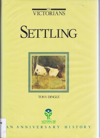
Book, Settling: The Victorians. By Tony Dingle, 1984_
... Aboriginal land use to European settlement.... Aboriginal land use to European settlement. Published to commemorate ...Part 2 of a 3-part series deals with land use from Aboriginal land use to European settlement.Published to commemorate the 150th anniversary of European settlement in Victoria.Hard cover. 274 pages, illus., maps, end maps.victoria land use, victoria history, victoria social conditions, tony dingle -
 Emerald Museum & Nobelius Heritage Park
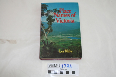
Book, Place Names of Victoria, 1977
... of land discovery and settlement. Starting from the native... of naming was a chronological representative of land discovery ...The sequence of naming was a chronological representative of land discovery and settlement. Starting from the native population to the explorers, the squatters and settlers and surveyors during the gold rush. The term 'places' refers to physical features of the coast and land as well as districts, towns and cities.Hard Cover book written by Les Blake and first published in 1977. The jacket has a photograph of Mount Beauty and the Kiewa Valley from the Tawonga Gap.place names of victoria -
 Port Melbourne Historical & Preservation Society
Booklet, State Government of Victoria, Making the Most of the Bay, 1990
... booklet considering environment, land use and settlement... booklet considering environment, land use and settlement ...Making the Most of the Bay - Plan for the protection and development of Port Phillip and Corio Bays, November 1990. An A4 booklet considering environment, land use and settlement, recreation and tourism, coastal and marine industries. Detailed recommedations for specific areas and foreward by Ministers Steve Crabb and Andrew McCutcheon (ref. item 1414, draft version)state government victoria, natural environment - conservation -
Clunes Museum
Document - REPORT, HEPBURN SHIRE, 2024
... .1 RURAL HEPBURN - AGRICULTURAL LAND STUDY AND RURAL... TO LANDSCAPE VARIATION AND DRIVERS OF LAND USE CHANGE ...PLANNING POLICY PRINCIPLES WILL BE TAILORED TO RESPOND TO LANDSCAPE VARIATION AND DRIVERS OF LAND USE CHANGE AND THE DIFFERENTIAL IMPACT THAT THESE HAVE ACROSS THE SHIRE....1 RURAL HEPBURN - AGRICULTURAL LAND STUDY AND RURAL SETTLEMENT STRATEGY, UNBOUND REPORT PRINTED IN COLOUR ON PAPER, 94 PAGES .2 FUTURE HEPBURN - CLUNES STRUCTURE PLAN, UNBOUND REPORT PRINTED IN COLOUR ON PAPER, 67 PAGES ADOPTED BY HEPBURN SHIRE COUNCIL 3 SEPTEMBER 2024hepburn shire council, rural settlement strategy -
 Port Fairy Historical Society Museum and Archives
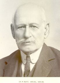
Photograph, Cr William Boyd Shire of Belfast President 1891-92 95-96
... Settlement land after the Second World War.... to become part of the Soldier Settlement land after the Second World ...Councillor William Boyd was the son of Alexander Boyd who emigrated from Scotland and purchased the property known as Tarrone station in 1884. William managed the station grazing cattle and sheep. The area was later to become part of the Soldier Settlement land after the Second World War.Black and white portraitbelfast, president, government, portrait, shire, council, municipal, local-government, tarrone -
 Lake Bolac & District Historical Society
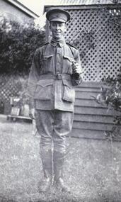
Black and white photograph, Gunner Stanley Herbert Moreton, Field Artillery Brigade, WW1
... of land for soldier settlement. He died in 1978 at the age of 85.... with the subdivision of land for soldier settlement. He died in 1978 at the age ...Gunner Stanley Herbert Moreton, enlisted 04/12/1916 in a Field Artillery Unit. He embarked for France on 11/05/1917. Upon his return from the war, he purchased 'Parupa Park'. After WW2 Stanley was involved in helping with the subdivision of land for soldier settlement. He died in 1978 at the age of 85.moreton, field artillery unit, 'parupa park', soldier settlement, -
 Federation University Historical Collection
Photograph - Colour, Chatham-Holmes Collection: Trawalla Estate, Victoria - Soldier Settlement
... and subdivided by the Commonwealth Government for the Soldier Settlement... and subdivided by the Commonwealth Government for the Soldier Settlement ...In 1917 a large part of the Trawalla estate was acquired and subdivided by the Commonwealth Government for the Soldier Settlement Scheme. Land was subdivided into 93 allotments with sizes from 250 acres to 680 acres. The land was deemed appropriate for grazing and farming.chatham-holmes collection, soldier settlement, langi kal kal, auction, philip chatham, trawalla -
 Halls Gap & Grampians Historical Society
Photograph - B/W, C 1900
... land that the first settlement, Ladysmith, sprang up.... Mason's Farm and it was on Mason's land that the first settlement ...In early 1900, three Emmett brothers, with support from George Mason, set about following up a report of gold in the area. Confirmation of gold led to a gold rush in June 1900. Traffic from Ararat and Willaura passed Mason's Farm and it was on Mason's land that the first settlement, Ladysmith, sprang up.Road leading to Mt William goldfield 1900. George Mason's farmhouse on right hand side of road.access routes, roads, mining, ladysmith -
 Orbost & District Historical Society
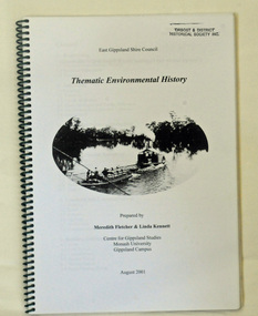
book, Thematic Environmental History, 2001
... on the discovery, settlement and land usage of East Gippsland as well... on the discovery, settlement and land usage of East Gippsland as well ...This booklet was prepared for the East Gippsland Shire Council in August 2001.A Thematic Environmental History identifies how key patterns of development have influenced the culture of the area and the natural and built environment. The document is not a social history but usually provides the context for future heritage studies and assessments and would provide input to the preparation of a Heritage Action Plan. This booklet prepared for the East Gippsland Shire councilA spiral bound book of 75 pp, titled Thematic Environmental History, prepared by Meredith Fletcher and Linda Kennett for the Centre for Gippsland Studies, Monash University, Gippsland Campus. On the front cover is a black and white drawing of a paddle steamer towing a barge along a river. It contains information on the discovery, settlement and land usage of East Gippsland as well as the development of transport, communication and cultural institutions. Copywright held by East Gippsland Shire Council and Department of Infrastructureenvironmental-study-east-gippsland -
 Warrnambool and District Historical Society Inc.
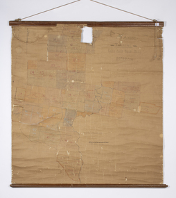
Map - Soldier Settlement Map, Soldier Settlement Commission, Tarrone Estate Alex Boyd, 1940s
... This is a map of the Tarrone Soldier Settlement land... This is a map of the Tarrone Soldier Settlement land divisions probably ...This is a map of the Tarrone Soldier Settlement land divisions probably produced by the Soldier Settlement Commission. The map is incomplete with lots 48,49 and 50 missing. The Soldier Settlement Commission purchased 23,373 acres of Tarrone Station from the Boyd brothers in 1947 and the sub divided lots were occupied by soldier settlers commencing in 1949. Tarrone Station was established in 1840 by Doctors Kilgour and Bernard and the Boyd brothers secured the free hold in the 1890s and retained it until 1947. The map hung for many years in the Warrong school near Hawkesdale.This map is of considerable interest as an original item from the establishment of the Tarrone Soldier Settlement..The map is made of brown cloth and creased. The edges are tattered and there is a piece missing at the top. It is a map of allotments, hand drawn and with faded colours in red, blue and yellow. The names of localities and land holders are hand written in ink and chalk. The map is contained within two pieces of wood at the bottom and the top. There are two screws and a cord to hang on a wall. A scale of measurement is shown under the map. tarrone soldiers settlement, boyd brothers tarrone -
 Bendigo Historical Society Inc.
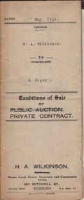
Document - H.A. & S.R. WILKINSON COLLECTION: CONDITION OF SALE
... between H.A. Wilkinson (seller) and S. Rigby (buyer) for land.... Wilkinson (seller) and S. Rigby (buyer) for land within the special ...Conditions of sale by private contract dated 12th May, 1932 between H.A. Wilkinson (seller) and S. Rigby (buyer) for land within the special settlement area situate Junortoun containing 17 acres, 1 rood, 27 perches being allotment 37F Parish of Wellsford, County of Bendigo described in Crown grant volume 4485 folio 896958, together with 4-roomed weatherboard dwelling and all sundry. Price 575 pounds.organization, business, h.a. & s.r wilkinson real estate -
 Bendigo Historical Society Inc.
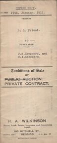
Document - H.A. & S.R. WILKINSON COLLECTION: CONTRACT OF SALE
... conditional purchase lease of special settlement area land from... purchase lease of special settlement area land from the Crow ...Conditions of sale by private contract dated 19th January, 1931 between R.L. Priest (seller) and F.S. Shepherd & C.A. Shepherd (buyer) for land situate Epsom Road, Eaglehawk Flat, being conditional purchase lease of special settlement area land from the Crow, entered in the register book volume 1001 folio 200107, allotments 152B and 152C section N, containing 15 acres no roods 27 perches at the present occupied by Mr. Hummel as tenant. Together with 5-roomed weatherboard dwelling and all sundry. Price 250 poundsorganization, business, h.a. & s.r wilkinson real estate -
 Victorian Interpretive Projects Inc.
Photograph - Colour, Clare Gervasoni, Corenderrk Cemetery, 31/08/2011
... where he could establish a settlement. The land later named... where he could establish a settlement. The land later named ...In 1860 the Wurundjeri Elder, Wonga, petitioned the Victorian Parliament for a piece of land in his people’s own country where he could establish a settlement. The land later named Coranderrk was granted. When Wonga died in 1875 his nephew William Barak, known by settlers as ‘King William, last chief of the Yarra Yarra tribe’, became the leader, the Ngurungaeta. William Barak believed strongly in justice for his people, and time and again made the arduous walk to Melbourne to petition to Parliament and to Queen Victoria for his people. ‘Freedom for our lifetime’, he said. The community at Coranderrk welcomed Aboriginal people displaced from other parts of Victoria; they established an economically self-sufficient settlement by growing and marketing hops. Barak negotiated with the Victorian Government officials as they made promises and broke promises. They finally promised to export the whole of a hop harvest of one year. The people worked around the clock to fill the contract; the Government pocketed the proceeds. The community never recovered. Barak died in 1903— a broken-hearted man. (from http://www.sosj.org.au/_uploads/_cknw/files/Corenderrk.pdf) Artist William Barak is buried in this cemetery.Photographs of graves in grass and bushland. It is the Corenderrk Cemetery, and is associated with the former Corenderrk Aboriginal Reserve.corenderrk, wurundjeri, barak, aborigines, aboriginal, cemetery, grave, barak, jemima dunolly -
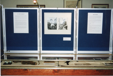 The Beechworth Burke Museum
Photograph, 1999
This photograph features three display board sections showing information and photographs from 'The Harvest' exhibition inside the Burke Museum at Beechworth in 1999. The boards are titled 'To the Market' and 'Orchards'; the accompanying text cannot be read. The two accompanying photographs depict a man and woman picking fruit.This photograph is of social significance to Burke Museum and the Beechworth community, documenting an exhibition, The Harvest, held in 1999 to communicate the importance of agricultural development, specifically of orchards, in the area. The expansion of vineyards and horticulture in the Beechworth district followed gold rush prosperity in the mid-1850s, with nearly ninety acres of gardens and small farms under vineyards by 1865. There were 400 Chinese market gardeners and hawkers in the area in 1868. The growth of agriculture in the Ovens district in the mid -1860s led to advocacy by local farmers for the extension of railway infrastructure from Melbourne to improve access to distant markets.Colour rectangular photograph printed on matte AGFA photographic paper.Obverse: TO THE MARKET / ORCHARDS/ Reverse: 2856beechworth, burke museum, promoting settlement, living in country towns, making regional centres, preserving traditions and commemorating, farming and agriculture, orchards, exhibitions, burke museum exhibitions, fruitpicking, building local economies, transforming land, victorian agricultural history, marketing and promoting agricultural products, growing fruit and vegetables, the harvest exhibition, harvests, vineyards, victorian gold rush towns -
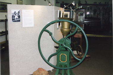 The Beechworth Burke Museum
Photograph, Estimate 1999
This photograph was taken in 1999 at 'The Harvest' exhibition at the Burke Museum for members of Baking Industry Victoria. The grain mill, manufactured by B.M. Purshouse in Wolverhampton, England, was of special interest.This photograph is of primary social significance to the Beechworth community because it depicts a 19th-century grain mill, manufactured by B.M. Purshouse in Wolverhampton, England, which was probably used at flour mills in the Ovens District, such as that at Tarrawingee, which opened in 1866. The purchase of agricultural machinery such as the grain mill accompanied the expansion of agriculture, including grain growing, in the Ovens District following the gold mining prosperity of the 1850s. This photograph may be of interest to researchers who wish to observe an image of the Purshouse grain mill.Colour rectangular photograph printed on matte AGFA photographic paper.Obverse: THE HARVEST / THE HARVEST Reverse: 2854beechworth, burke museum, promoting settlement, living in country towns, making regional centres, preserving traditions and commemorating, farming and agriculture, exhibitions, burke museum exhibitions, building local economies, transforming land, victorian agricultural history, marketing and promoting agricultural products, the harvest exhibition, harvests, victorian gold rush towns, grain mill, bm purshouse, crops and grain, baking industry victoria -
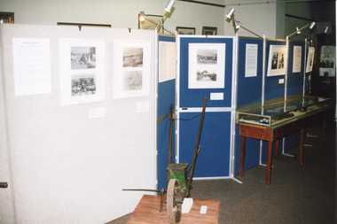 The Beechworth Burke Museum
Photograph, 1999
Taken in 1999, the photograph depicts a section of “The Harvest” exhibition held at the Burke Museum between May 1st and June 20th 1999 as part of the Baking Industry Victoria. In the foreground is believed to be an old seed distributor. The grain mill made by B. M. Purshouse in Wolverhampton, United Kingdom, was of special interest during the exhibition. This photograph is of historical and research significance, connecting with various themes such as farming, adapting to diverse environments, and the promotion of settlement in Victoria. The photograph is an example of an exhibition held at the Burke Museum in 1999, demonstrating the communal interest of Beechworth in their farming history. The photograph contains a strong interpretive capacity as it demonstrates the importance of farming to Beechworth and Beechworth's history, revealing the enduring connection between the local community and the surrounding land. The historical and research value of the photograph is further enhanced by the depiction of historical farming machinery, providing a means for future generations to view historical machines used in farming. Colour rectangular photograph printed on photographic paper.Reverse: 2857burke museum, the harvest, exhibition, baking industry, grain mill, b. m. purshouse, beechworth, baking industry victoria, seed, seed distributor -
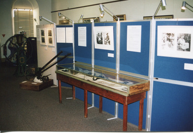 The Beechworth Burke Museum
Photograph, 1999
Taken in 1999, the photograph depicts a section of “The Harvest” exhibition held at the Burke Museum between May 1st and June 20th 1999 as part of the Baking Industry Victoria. In the foreground is depicted a seed distributor. The grain mill, which can be seen in the background, was made by B. M. Purshouse in Wolverhampton, United Kingdom, and was of special interest during the exhibition. This photograph is of historical and research significance, connecting with various themes such as farming, adapting to diverse environments, and the promotion of settlement in Victoria. The photograph is an example of an exhibition held at the Burke Museum in 1999, demonstrating the communal interest of Beechworth in their farming history. The photograph contains a strong interpretive capacity as it demonstrates the importance of farming to Beechworth and Beechworth's history, revealing the enduring connection between the local community and the surrounding land. The historical and research value of the photograph is further enhanced by the depiction of historical farming machinery, providing a means for future generations to view historical machines used in farming.Colour rectangular photograph printed on photographic paper.Reverse: 2855burke museum, the harvest, baking industry, baking industry victoria, seed distributor, grain mill, b. m. purshouse, beechworth, exhibition -
 The Beechworth Burke Museum
Audio - Oral History, Jennifer Williams, Mrs Val Mason, 5 January 2001
Mrs. Valerie (Val) Mason (1927-2019) was a local sheep farmer, business-woman, Beechworth shire councillor, and mother to five children. With her husband, Charles, Mrs. Mason developed and managed the Big Valley farm estate, at Everton, which is now part of a vineyard and farm stay. Mrs. Mason was instrumental in introducing a 'paddock to plate' philosophy and business model, opening a butcher shop on the farm in 1973. Concerned with improving infrastructure and developing economic opportunities in the region, Mrs. Mason successfully stood as a local council representative for South Riding in the United Shire of Beechworth, and later become the first woman Shire President in 1979. Mrs Mason was a member of the local Business and Professional Women's Club for 37 years. This oral history recording was part of a project conducted by Jennifer Williams in the year 2000 to capture the everyday life and struggles in Beechworth during the twentieth century. This project involved recording seventy oral histories on cassette tapes of local Beechworth residents which were then published in a book titled: 'Listen to what they say: voices of twentieth century Beechworth. These cassette tapes were digitised in July 2021 with funds made available by the Friends of the Burke.Mrs. Mason's story is historically significant for understanding economic and social changes in the Beechworth region during the latter half of the twentieth century. As a council representative, issues such as road and infrastructure modernisation and the transition from traditional government employment sectors, like Beechworth's care institutions, were challenges for local government. As a farmer and local employer, Mrs. Mason's story is testimony to the region's economic diversification as businesses like Big Valley farm shop helped shape the region's contemporary character. Mrs. Mason was among the first women to broach the traditionally all-male Beechworth Council Chambers and her story is socially significant for understanding the changing role of women in rural and regional Australia. This oral history recording offers interpretive capacity for social history themes and may be compared with other oral histories in the Burke Museum's collection. This oral history account is socially and historically significant as it is a part of a broader collection of interviews conducted by Jennifer Williams which were published in the book 'Listen to what they say: voices of twentieth-century Beechworth.' While the township of Beechworth is known for its history as a gold rush town, these accounts provide a unique insight into the day-to-day life of the town's residents during the 20th century, many of which will have now been lost if they had not been preserved.This is a digital copy of a recording that was originally captured on a cassette tape. The cassette tape is black with a horizontal white strip and is currently stored in a clear flat plastic rectangular container. It holds up 40 minutes of recordings on each side.Mrs Val Mason /listen to what they say, beechworth, oral history, burke museum, working women, trail blazers, farm to plate, farm shop, paddock to plate, woman farmer, united shire of beechworth, rural and regional women, beechworth's first woman shire president, women in leadership positions, women leaders, australian settlement history, settler societies, victorian gold rush, heritage tourism, culinary tourism, regional land use, indigo winery, farm stay, social history -
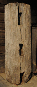 Orbost & District Historical Society
fence post, 1840's
This fence post is from the original Snowy River Station stock yards which were where "Merindah" stands today. It was probably owned by the Marshall family at the time of transfer to "Merindah" in 1985. It was lifted out by Geoff Stevenson with a bucket on a tractor in 1986. The post was originally twice the length. The Snowy River Station was established in 1842 by Peter Imlay. In 1845 the land was sold to Norman MCLeod who named the area Orbost. After financial difficulties in the 1870's the run was taken over by W.J.Clarke and known as Orbost Station.Peter Imlay established the first white settlement in 1842 settling on the eastern side of the Snowy River where the township of Orbost now stands. This settlement was the Snowy River Station. A corner post from a post and rail fence. It is possibly made of red box.. On one side are three rectangular sections cut out with a similar one on the other sides. The post is hollow and has metal staples in the sides for attaching wires.orbost-station mcleod fence-post -
 Orbost & District Historical Society
map/poster, Victorian Government Printer, 22.4.1926
The Department of Crown Lands and Survey was originally established in 1857 as part of the Board of Land and Works. In 1964 it ceased to be controlled by the Board. The Department functioned for almost twenty more years before being combined with other Ministries to form the Department of Conservation, Forests and Land. It was responsible for the management of the State's Crown land and pastoral estates. This map was used by Don Mehlert after 1928. The VERMIN AND NOXIOUS WEEDS ACT 1928 was an Act to consolidate the Law relating relating to Vermin and Noxious Weeds. E. J. E. G. Pemberton who published this poster was Superintendent of Field Staff, Dept. of Lands and Survey. This map and posters are significant records of early settlement history in Murrangower, between Cabbage Tree and Orbost,A paper map of Murrangower showing settlement subdivisions. This is glued onto the back of four overlapping cloth poster of "Notices of Vermin Destruction". All print is black."DON MEHLERT" in black pen. Pike's block shaded in blue. School site marked in blue pencil. on poster "MURRANGOWAR" along side.map-murrangower poster-vermin-and-noxious-weeds murrangower-settlement