Showing 3056 items matching "public buildings"
-
 Warrnambool and District Historical Society Inc.
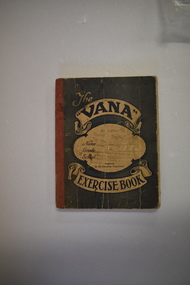
Tradesman’s Work Diary, Book, 1940s
... , and Warrnambool Technical School and for other public buildings including..., and Warrnambool Technical School and for other public buildings including ...This exercise book contains details on the work carried out by A.Greed, a tradesman undertaking small carpentry and repair jobs in the Warrnambool region. The works completed date from 17 April 1945 to 11 October 1949. Mr Greed apparently worked mostly for the Public Works Department and had contracts for schools including Ecklin South, Panmure, Cudgee, Dennington, Mailors Flat, Grasmere, and Warrnambool Technical School and for other public buildings including the Warrnambool Court House, the Police Station and Housing Commission buildings. Other contracts included ones for the Framlingham Aboriginal Reserve, Callaghan’s Garage, the Caledonian Hotel, the Methodist Croquet Club and many private home owners. Details on the identity of ‘A. Greed’ are not known as there are several possibilities for the 1940s era. One clue is that an ‘E. Greed’ was also an employee.This exercise book is of some interest as an example of a tradesman’s handwritten details of his work as a carpenter and repair man in the 1940s in the Warrnambool area. There are many local names and businesses of interest mentioned in the exercise book. This is an exercise book with a grey cover with red binding. The dark blue printing on the front cover is enclosed in scroll patterns and the back cover has dark blue printing The cover is creased and has some ink splotches. The front cover has been stamped but the printing is now mostly illegible. The pages contain handwritten work and accounting information in black and blue ink. Some pages have been overwritten in red and black ink and pencil and there is one loose sheet.The Vana Exercise Booka.greed,, warrnambool tradesman, history of warrnambool -
 Eltham District Historical Society Inc
Photograph, Officers in charge of Eltham Police Station (1857-2015), 22 Sep 2018
... and is the oldest public building in the district. In 1959 the Victoria... and is the oldest public building in the district. In 1959 the Victoria ...The first Eltham Police Station was in the small building opposite Dalton Street rented from Mr Jarrold in 1857. In 1859 a dedicated Police Residence was built at 728 Main Road. A small weatherboard Police Station was attached to the side of the residence and a blue stone cell at the rear. Also on site were stables for the police horses. The Eltham Courthouse was built in 1860 and is the oldest public building in the district. In 1959 the Victoria Police purchased a house in Pryor Street to be refurbished as the Eltham Police Station. In 1961 the Police in Eltham move into Pryor Street refurbished buildings and office. During 2001 to 2002, the Eltham Police Station was demolished and a new complex constructed on site. The original 1859 Police residence is now home to the Eltham District Historical Society.albert frederick charles glover, allan fenton, arthur eggleston dungey, bertie stanton, charles briant, charles thomas martin, clyne harold mcphan, ebenezer williamson, eltham police station, gerard joseph o'toole, graham vincent joyce, harold shields, ian william bruce, isaac newton stevens, james boxhall, james chester draper, john scully, john stanley mcgough, john stuart bateman, john thomas cone, myles archibald lyons, peter lawlor, richard roberts, robert harry chrisfield, robert llewellyn, samuel james king, samuel o'donnell, sidney frederick little, thomas maher, victoria police, william charles sargeant, james francis fitzpatrick -
 Orbost & District Historical Society
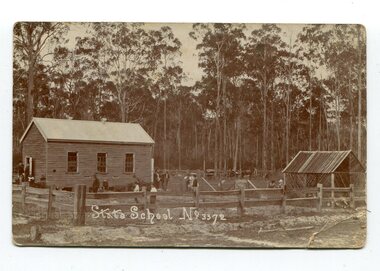
black and white photograph, 1908
... . It was the first public building for the Cann Valleyand was first used.... It was the first public building for the Cann Valleyand was first used ...This item is part of the Mary Gilbert Collection. Noorinbee School, situated on the Bombala Rd approximately 6.5 km north of Cann River, was opened on 26th of July 1900, with Albert Le Page as head teacher until 30th of September 1904. The school no longer functions. A school bus would daily to take the older children to the central classes at Cann River. "Noorinbee" is an Aboriginal word of unknown origin, The historical school is still at the front of the school yard. The Old Noorinbee School was been shifted twice. The first time they used a bullock team in 1924. The second time they used trucks and tractors in 1991. It was the first public building for the Cann Valleyand was first used as a hall and a church until it became the Noorinbee school in 1900. It was built in 1898.This item is associated with education in East Gippsland. It is also associated with the Gilbert family.A black / white photograph / postcard which has a letter written on the back. On the front is a small wooden building, a shed on the right, a wooden fence at the front with children scattered in the yard.on front - "State School No 3372" on back - " Mrs J. Gilbert Talangoota, Orbost"gilbert-annie noorinbee-state-school education-east-gippsland -
 Mont De Lancey
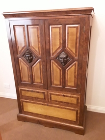
Furniture - Cabinet, Mr Franz Streizel, Unknown
... in public buildings and honour boards throughout Australia... contributed to the wood carvings in public buildings and honour boards ...This cabinet is part of a special bequest to the Mont De Lancey Museum of hand carved furniture and items made by Mr Franz Striezel by his grandaughter Mrs Dorothy Hilda Adamson. Dorothy was a friend of Nella Lord (nee Sebire). Dorothy passed away in 2007. It was to be known as The Franz Striezel Collection. Franz Streizel came from Germany in 1886 and was one of the three recognised craftsmen (Art Carvers) in Australia who contributed to the wood carvings in public buildings and honour boards throughout Australia. The National Gallery at their request had two small panels and a tobacco jar (some of his work), donated by Mrs D Adamson. They considered these pieces highly valuable. it was a wedding gift to Mr Franz Streizel's daughter Frieda Streizel approximately 1910. A heavily inlaid veneer two door cabinet with carved Egyptian style heads in the middle of each door set in a triangular pattern. There are two small drawers and one long drawer at the bottom of the cabinet. Keys are kept nearby in a wooden box in the same collection.cabinets, furniture, storage and display furnirure -
 Mont De Lancey
Furniture - Dressing table, Mr Franz Streizel, Unknown
... ) in Australia who contributed to the wood carvings in public buildings... in public buildings and honour boards throughout Australia ...The dressing table is part of the Franz Streizel Collection. It was given to Mrs Dorothy Adamson on the occasion of her wedding. It is part of a special bequest to the Mont De Lancey Museum of hand carved furniture and items made by Mr Franz Striezel by his grandaughter Mrs Dorothy Adamson. Dorothy was a friend of Nella Lord (nee Sebire). Dorothy passed away in 2007. It was to be known as The Franz Striezel Collection. Franz Streizel came from Germany in 1886 and was one of the three recognised craftsmen (Art Carvers) in Australia who contributed to the wood carvings in public buildings and honour boards throughout Australia. The National Gallery at their request had two small panels and a tobacco jar (some of his work), donated by Mrs D Adamson. They considered these pieces highly valuable.An ornately carved rosewood dressing table with a moveable mirror which moves backwards and forwards for use. It has two ornately carved small shelves at the sides attached to the mirror, one small central drawer, shaped sides above the top of the lower dressing table top. There are two small and two large drawers below with ornate brass handles. There is an inlaid pattern on the front of the drawers. There are three framed photographs - 1. A portrait of Dorothy Adamson. 2. A portrait of Karl Adamson. 3. A wedding photograph of Dorothy with two bridesmaids. Ornaments and a doiley are displayed on the dressing table.dressing tables, tables, furniture, photographs -
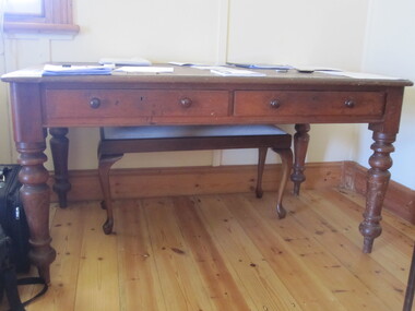
 Parks Victoria - Cape Nelson Lightstation
Furniture - Desk
... public buildings and infrastructure as well as the supply... public buildings and infrastructure as well as the supply ...The desk was used by the head keeper and supplied by the Public Works Department, and possibly dates to when the lightstation commenced operations in 1884. Closer inspection of the wood may reveal the Crown motif and PWD monogram on the side or underpart of the furnishing. The PWD operated in Victoria from 1855 to 1987 and was responsible for the design of Victoria’s major public buildings and infrastructure as well as the supply of stores, furniture and equipment. The desk is identical to the large example remaining at Point Hicks. A smaller version, which is at Cape Schanck, has two sides stamped with the crown motif and PWD monogram. Another of the smaller desks formerly at Cape Schanck is now missing. Gabo Island has a small cedar desk or table in the same style, but with one drawer. There are also c.mid‐twentieth century desks remaining in the collections at Wilsons Promontory and Gabo Island. The Cape Nelson desk has first level contributory significance for its provenance and historical value as a government issued furnishing that is original to lightstation’s head keeper’s office.The large, late nineteenth century cedar desk has two drawers, leather inset top and sturdy turned legs. The drawers each have a pair of wooden knob pulls. -
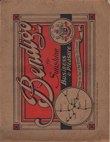 Bendigo Historical Society Inc.
Book - BENDIGO FOR SUNSHINE BUSINESS AND PLEASURE
... various tourist attraction, buildings,shops, industries. Some..., William Wallace, Public Buildings, Lake Weeroona, Bendigo Business ...Bendigo for Sunshine Business and Pleasure, under the seal of the Bendigo City Council. Published by Bolton Bros Pty Ltd, Centreway, Bendigo. The book has 56 pages of early Bendigo photos, depicting various tourist attraction, buildings,shops, industries. Some of the photes: Herbert Keck&Sons, Commercial House, Tomlins-Simmie&co. Flour Millers,The Beehive, W. Cowling, The School of Mines, Chemists of Bendigo, Bolton Bros, Prescott and Dawe, Churches of Bendigo, W.J. Lenten, Myer,Favaloro, Electric Light- Poer and Tramway, Bartlett Bros, Baker&Woods, William Wallace, Public Buildings, Lake Weeroona, Bendigo Business College, Leggo's of Bendigo, Rosalind Park, Stillwell, Bendigo Pottery, Warren's Emporium, Randall's, Chatfield, Frank Monaghan, Rickards Bros, Cocking's Bargain Centre, Whitelock & Carter, Bucknell & Jeffrey, The Bendigo Advertiser, Charing Cross, Hartley Bros, Cohn Bros, Bendigo Art Gallery, J.B. Wilson.bendigo, history, photographic history -
 Ballarat Heritage Services
Photograph - Photograph - Colour, Clare Gervasoni, Koroit Post Office, 2015, 21/12/2015
... of a number of significant public buildings and leads to a street... of a number of significant public buildings and leads to a street ...The town borrows its name from the Koroitch Gundidj people who occupied the area prior to European settlement. (https://en.wikipedia.org/wiki/Koroit, accessed 21 December 2016) Koroit was first surveyed as a township in 1847. Around the 1850 the district had the highest population of Irish immigrants in rural Australia. The Koroit Post Office was designed by architect and engineer John Mason of Port Fairy. (Moyne Shire Heritage Study 2006 Stage 2, Volume 2: Environmental History, Prepared for Moyne Shire Council Helen Doyle in association with Context Pty Ltd, 2006.) Rosebrook Bridge, Rosebrook (1853; replaced) Post Office buildings, Bank Street, Port Fairy (c.1857) The author Henry Handel Richardson lived in the Koroit Post Office as a child after her family moved to Koroit in 1878. Remembering Koroit from her youth, the third volume in her The Fortunes of Richard Mahony trilogy is set in the town. When the author was six, her father Walter died in Koroit on 1 August 1879 and was buried at the Koroit cemetery. (https://en.wikipedia.org/wiki/Koroit, accessed 21 December 2016) In 1878 Mary Richardson was appointed postmistress of the Koroit Post Office at a salary of 72 pounds with free quarters, firewood and kerosene. She lived at the back of the Post Office. (From a Green and Pleasant Land by H. McCorkell and P. Yule.) Photographs showing the bluestone Koroit Post Office, phone box and postbox. It is located at 99 Commercial Road, Koroit. "Historic Area Statement of Significance: The significance of Koroit derives from its role as the urban centre of one of the most concentrated Irish Roman Catholic rural districts in Australia, noted for its mixed livestock and cropping argicultural patterns. This is reflected in two separate and distinctive areas in the town - the administrative/commercial area and the church precinct. The administrative and commercial area (focussing on the Boundary-Commercial Road/High Street intersection and the Koroit Hotel) consists of a number of significant public buildings and leads to a street of relatively intact humble shopfronts and kerbline verandahs, visually punctuated by opposing bank facades. The church precinct is dominated by a group of Catholic buildings larger in scale and more complete in range than those in any comparably sized Victorian town." http://vhd.heritagecouncil.vic.gov.au/places/69338#sthash.ELLuSMvg.dpuf, accessed 21 December 2016."koroit, post office, phone box, payphone, bluestone, henry handel richardson, koroit post office -
 Kew Historical Society Inc
Plan, Melbourne and Metropolitan Board of Works, Borough of Kew : Detail Plan No.1562, 1905
... ), weatherboard constructions (yellow), and public buildings (grey). MMBW...), and public buildings (grey). MMBW detail plan No.1562, in contrast ...The Melbourne and Metropolitan Board of Works (MMBW) plans were produced from the 1890s to the 1950s. They were crucial to the design and development of Melbourne's sewerage and drainage system. The plans, at a scale of 40 feet to 1 inch (1:480), provide a detailed historical record of Melbourne streetscapes and environmental features. Each plan covers one or two street blocks (roughly six streets), showing details of buildings, including garden layouts and ownership boundaries, and features such as laneways, drains, bridges, parks, municipal boundaries and other prominent landmarks as they existed at the time each plan was produced. (Source: State Library of Victoria). This plan forms part of a large group of MMBW plans and maps that was donated to the Society by the Mr Poulter, City Engineer of the City of Kew in 1989. Within this collection, thirty-five hand-coloured plans, backed with linen, are of statewide significance as they include annotations that provide details of construction materials used in buildings in the first decade of the 20th century as well as additional information about land ownership and usage. The copies in the Public Record Office Victoria and the State Library of Victoria are monochrome versions which do not denote building materials so that the maps in this collection are invaluable and unique tools for researchers and heritage consultants. A number of the plans are not held in the collection of the State Library of Victoria so they have the additional attribute of rarity.Original survey plan, issued by the MMBW to a contractor with responsibility for constructing sewers in the area identified on the plan within the Borough of Kew. The plan was at some stage hand-coloured, possibly by the contractor, but more likely by officers working in the Engineering Department of the Borough and later Town, then City of Kew. The hand-coloured sections of buildings on the plan were used to denote masonry or brick constructions (pink), weatherboard constructions (yellow), and public buildings (grey). MMBW detail plan No.1562, in contrast to No.1561 includes the names of a large number of houses: in Barkers Road: ‘Ashwick’, ‘Owasso’, ‘Anadiha’, ‘Eurobin’, ‘Carlsruhe’, ‘Arlington’ and ‘Altyre’. Unnamed but clearly represented on the plan is what was then known as the ‘Auburn Heights Recreation Club’, which at this stage included a Bowling Green, a Croquet Green and two Tennis Courts. On the plan, Brougham Place, as it was then known, is represented. It was later renamed Daniell Place. The aforementioned Arlington is now the junior campus of Preshil. melbourne and metropolitan board of works, detail plans, mmbw 1562, cartography -
 The Beechworth Burke Museum
Photograph, 1877
... of the public buildings in Melbourne and Victoria. Arthur Ebden Johnson... of the public buildings in Melbourne and Victoria. Arthur Ebden Johnson ...Taken in Beechworth 1867, this photograph depicts the Bank of Victoria on the corner of Camp and Ford Street. This building was erected in 1867 to replace the former bank that was destroyed by a fire on the same site. This classical style structure was designed by architects Smith and Johnson who designed many of the public buildings in Melbourne and Victoria. Arthur Ebden Johnson, 1821–1895 and Alfred Louis Smith, 1830–1907 were appointed as the Bank of Victoria's architects who, in-conjunction with the Branch in Beechworth, also completed branches in Wangaratta and Bendigo. This photograph was taken and produced by the American and Australasian Photographic Company which was founded by Beaufoy Merlin joined by his assistant, Charles Bayliss and Augustus Clinton, and operated between 1866-1873. The company traveled throughout Victoria and New South Wales before establishing a portrait studio in Sydney. There is no apparent connection to America. Sepia rectangular photograph. Image is printed on matte photographic paper and has a white border.Reverse: 1997.2727 (in pencil) Bank of Victoria / Beechworth / 1877 (in pen) Harvey Collection American & Australasian / Photographic Company / Victoria Branch / C. Bayless, Manager No 56beechworth, bank of victoria, american and australasian photographic company, 1877, c.bayless, harvey collection, arthur ebden johnson, alfred louis smith, smith and johnson -
 Eltham District Historical Society Inc
Slide - Photograph, Eltham Courthouse, 730 Main Road, Eltham, c.May 1988
... Built in 1860, the Eltham Courthouse is the oldest public... melbourne Built in 1860, the Eltham Courthouse is the oldest public ...Built in 1860, the Eltham Courthouse is the oldest public building remaining in Eltham. In its early days the building was used as the meeting place and office of the Eltham District Road Board and as an overflow classroom for the local school. The Eltham Courthouse ceased operational duties in 1984 and is now used by various community groups including Eltham District Historical Society. It was listed on the Victorian Heritage Register (Number H0784) in 1982. The building is of architectural significance because it retains intact early features. These include use of handmade bricks, simple decoration, roof trusses, timber ceiling boards, original windows, doors and associated hardware and a collection of court furniture. Additions to the court house have been done in a manner which did not interfere with the fabric of the original building. It is a fundamental asset in the Eltham Justice Precinct and is being fully restored in 2021 thanks to Nillumbik Shire Council.35mm colour positive transparency (1 of 23) Mount - Kodak EktachromeProcess Date MAY 88Meltham, eltham courthouse, main road -
 Ballarat Heritage Services
Photograph - Photograph - Colour, Clare Gervasoni, Kalimna Honour Board, 27/08/2017
... Waschatz, decorating private homes and public buildings. From 1891... and modeller Otto Waschatz, decorating private homes and public ...This honor board was made by Robert Prenzel (1866–1941) who was born and trained in Prussia, and migrated to Australia arriving in Melbourne on 24th November on the steamer Habsburg. In Melbourne Prenzel first worked for the German sculptor and modeller Otto Waschatz, decorating private homes and public buildings. From 1891-1901 Prenzel worked in partnership with another German, Johann Christian Treede, after which he continued in business on his own. He also participated in the activities of Melbourne’s Deutscher Turnverein. During the first quarter of the current century he became the major exponent in the field of furniture and woodwork of the cult of nationalism, and was renowned for his carvings, many of them in the art nouveau style, of Australian animals, birds, trees and flowers. The two most common types of Australian timber in his work are mountain ash and blackwood.Colour photographs of a beautifully carved World War One Honour Board carved by Robert Prenzel.world war one, kalimna, kalimna honour board, h. clements, w.a. fish, d. mcdougall, j.a. rowe, c.c. sandford, c.d. somerville, l.j. cowlishaw, l.c. fish, t. hanson, c.a. innes, a.c. lester, j.a. lake, g.j. ward -
 Ballarat Heritage Services
Photograph - Photograph - Colour, Clare Gervasoni, Lakes Entrance and District Honour Board, 27/08/2017
... Waschatz, decorating private homes and public buildings. From 1891... Waschatz, decorating private homes and public buildings. From 1891 ...This honor board was made by Robert Prenzel (1866–1941) who was born and trained in Prussia, and migrated to Australia arriving in Melbourne on 24th November on the steamer Habsburg. In Melbourne Prenzel first worked for the German sculptor and modeller Otto Waschatz, decorating private homes and public buildings. From 1891-1901 Prenzel worked in partnership with another German, Johann Christian Treede, after which he continued in business on his own. He also participated in the activities of Melbourne’s Deutscher Turnverein. During the first quarter of the current century he became the major exponent in the field of furniture and woodwork of the cult of nationalism, and was renowned for his carvings, many of them in the art nouveau style, of Australian animals, birds, trees and flowers. The two most common types of Australian timber in his work are mountain ash and blackwood.Colour photographs of a beautifully carved World War One Honour Board by Robert Prenzel.lakes entrance, robert prenzel, world war one, lakes entrance honour board -
 Bendigo Historical Society Inc.
Document - HARRY BIGGS COLLECTION: EAGLEHAWK LOGS APPEAL, 1970
... Public Buildings Reserve Eaglehawk. Item 4 - Memorandum... Public Buildings Reserve Eaglehawk. Item 4 - Memorandum ...Document. Harry Biggs Collection. Item 1 - A letter with Borough of Eaglehawk letterhead to Mr H. Biggs, Royal Historical Society of Victoria Bendigo Branch, dated 9/9/1970, Re the Log Lock-up, Eaglehawk. It acknowledges a report sent to it & says a request for the Historical Society to become a committee of Trust for this building is being ascertained. Stamped with Reply affirmative11/10/70. Item 2 - a similar letter dated 18/9/1970 saying final decision will be held over. Item 3 - Instruction in letter form to Bendigo Historical Society Eaglehawk to plan & report the proposed Public Buildings Reserve Eaglehawk. Item 4 - Memorandum to Engineer's Report 17/9/1970 with recommendations for the various areas - Court House, Senior Citizens Club, Historical Society, Council Depot, Toilet Block, Occupied Land. Item 5 - Formal Engineers plan of Borough of Eaglehawk. Item 6 - Log Lock-up Appeal - list of donors.place, building, site, harry biggs collection, log lock-up appeal, eaglehawk -
 Kew Historical Society Inc
Plan, Melbourne & Metropolitan Board of Works : Borough of Kew : Detail Plan No.1578, 1904
... ), weatherboard constructions (yellow), and public buildings (grey). MMBW... (yellow), and public buildings (grey). MMBW Plan No.1578 ...The Melbourne and Metropolitan Board of Works (MMBW) plans were produced from the 1890s to the 1950s. They were crucial to the design and development of Melbourne's sewerage and drainage system. The plans, at a scale of 40 feet to 1 inch (1:480), provide a detailed historical record of Melbourne streetscapes and environmental features. Each plan covers one or two street blocks (roughly six streets), showing details of buildings, including garden layouts and ownership boundaries, and features such as laneways, drains, bridges, parks, municipal boundaries and other prominent landmarks as they existed at the time each plan was produced. (Source: State Library of Victoria). This plan forms part of a large group of MMBW plans and maps that was donated to the Society by the Mr Poulter, City Engineer of the City of Kew in 1989. Within this collection, thirty-five hand-coloured plans, backed with linen, are of statewide significance as they include annotations that provide details of construction materials used in buildings in the first decade of the 20th century as well as additional information about land ownership and usage. The copies in the Public Record Office Victoria and the State Library of Victoria are monochrome versions which do not denote building materials so that the maps in this collection are invaluable and unique tools for researchers and heritage consultants. A number of the plans are not held in the collection of the State Library of Victoria so they have the additional attribute of rarity.Original survey plan, issued by the MMBW to a contractor with responsibility for constructing sewers in the area identified on the plan within the Borough of Kew. The plan was at some stage hand-coloured, possibly by the contractor, but more likely by officers working in the Engineering Department of the Borough and later Town, then City of Kew. The hand-coloured sections of buildings on the plan were used to denote masonry or brick constructions (pink), weatherboard constructions (yellow), and public buildings (grey). MMBW Plan No.1578 is significant in that it defines the extent of two private schools: Xavier College and Kew High School (now part of Trinity Grammar) by 1904. In relation to the latter, the plan clarifies which buildings the High School operated from behind the mansion ‘Molina’. Established in 1902, Trinity Grammar was to later lease and subsequently buy Molina (now ‘Merritt House’) and ‘Elsinore’ (now ‘Roberts House’). Xavier College had been established in 1872. This 1904 plan delineates the West Wing and the Great Hall (built in 1890).melbourne and metropolitan board of works, detail plans, maps - borough of kew, mmbw 1578, cartography -
 Kew Historical Society Inc
Plan, Melbourne & Metropolitan Board of Works : Borough of Kew : Detail Plan No.1590, 1905
... ), weatherboard constructions (yellow), and public buildings (grey...), weatherboard constructions (yellow), and public buildings (grey ...The Melbourne and Metropolitan Board of Works (MMBW) plans were produced from the 1890s to the 1950s. They were crucial to the design and development of Melbourne's sewerage and drainage system. The plans, at a scale of 40 feet to 1 inch (1:480), provide a detailed historical record of Melbourne streetscapes and environmental features. Each plan covers one or two street blocks (roughly six streets), showing details of buildings, including garden layouts and ownership boundaries, and features such as laneways, drains, bridges, parks, municipal boundaries and other prominent landmarks as they existed at the time each plan was produced. (Source: State Library of Victoria)This plan forms part of a large group of MMBW plans and maps that was donated to the Society by the Mr Poulter, City Engineer of the City of Kew in 1989. Within this collection, thirty-five hand-coloured plans, backed with linen, are of statewide significance as they include annotations that provide details of construction materials used in buildings in the first decade of the 20th century as well as additional information about land ownership and usage. The copies in the Public Record Office Victoria and the State Library of Victoria are monochrome versions which do not denote building materials so that the maps in this collection are invaluable and unique tools for researchers and heritage consultants. A number of the plans are not held in the collection of the State Library of Victoria so they have the additional attribute of rarity.Original survey plan, issued by the MMBW to a contractor with responsibility for constructing sewers in the area identified on the plan within the Borough of Kew. The plan was at some stage hand-coloured, possibly by the contractor, but more likely by officers working in the Engineering Department of the Borough and later Town, then City of Kew. The hand-coloured sections of buildings on the plan were used to denote masonry or brick constructions (pink), weatherboard constructions (yellow), and public buildings (grey). Surveyed by the Board of Works in 1903 and published in 1904, Plan No.1590 shows development north of Cotham Road. While this plan includes built structures in Mary Street, Cotham Road, High Street, Park Hill Road, Kent Street, Ridgeway Avenue, and Ermington Lane (now Ermington Place), only part of this section was notated and coloured in this contractor’s copy. Numerous houses, large and small are named on the plan: ‘Cholula’, ‘Belper’, ‘The Uplands’, ‘Spring Grove’ facing Cotham Road; ‘Marion’ facing Kent Street; and ‘Kia Ora’ facing Ridgeway Avenue.melbourne and metropolitan board of works, detail plans, mmbw 1590, survey plans - borough of kew, cartography -
 Kew Historical Society Inc
Functional object, Jas Murray & Co, Wall Clock & Key, 1860s
... century, variants of which could be seen in shops, offices, public... in shops, offices, public buildings and stations. It has a mahogany ...The clock was purchased from Jas Murray & Co. of 107 Bourke Street East, Melbourne by Francis Barnard. James Murray & Co were well known clock and watchmakers operating from premises in London with branches in Calcutta and Melbourne. They were watchmakers and jewellers in Melbourne from 1860 to 1888. Francis Barnard established Barnard’s Pharmacy on the corner of Bulleen Road (later renamed High Street) and Cotham Road in 1857. In the early 1860s, after purchasing the clock, he placed it in his pharmacy where it could be seen by passers by. When he relocated across the road to 49 Bulleen Road (now 167 High St.) in 1880 he took the clock to the new premises. He maintained the accuracy of the clock so that local residents consulted it for the correct time, even after the Post Office building with its clock tower was opened in 1888. When Francis Barnard retired, his son took over the pharmacy. In 1925, the Barnard Pharmacy was sold to David Paton. The Paton’s were at first puzzled why people constantly peered in the door until they realised that the timepiece was the drawcard. When David Paton died in 1941, his widow sold the pharmacy but took the clock with her to her new florist shop at 145 High Street. When Mrs Paton retired in 1953, she took the clock to her home in Boronia. In 1973 her daughter donated the clock to the Kew Historical Society.Significant locally to Kew as an example of a timepiece that was used by the local community during the 19th century to tell the time.Barnard’s clock is a typical wall clock of the nineteenth century, variants of which could be seen in shops, offices, public buildings and stations. It has a mahogany case with a moulded wooden bezel encasing a hinged brass bezel housing the glass face which protects the dial and hands when working. The clock face has an off-white hand painted tin dial with black painted Roman numerals. The hands are black painted metal; the hour hand has a wide spade shaped point whilst the minute hand is much thinner. ‘Jas Murray & Co’ is painted above the centre, with ‘107 Bourke Street East’ and ‘Melbourne’ below, with the key hole in between. The clock movement is a fuse chain attached to a brass mainspring barrel which powers the pendulum for eight days. This is housed within a rectangular wooden casing with a convex curved base housing a hinged door giving access to the pendulum which is attached to the back of the clock by four wooden pegs.Jas Murray & Co / 107 Bourke St East / Melbournefrancis barnard, f g a barnard, high street - kew (vic), pharmacies - kew (vic), clocks, paton's pharmacy --- kew (vic.), bulleen road -- kew (vic.) -
 Warrnambool and District Historical Society Inc.
Mao, Borough of Warrnambool, County of Villiers, 1873
... district. Reserves, public buildings and some businesses are marked.... Reserves, public buildings and some businesses are marked. The map ...This is an early map of the Borough of Warrnambool (1872/3) showing the central town area of Warrnambool and the surrounding district. Reserves, public buildings and some businesses are marked. The map was photolithographed by John Noone, a Melbourne artist and photographer who claimed in 1858 to have the oldest-existing photographic studio in Melbourne. Photolithography was a process first developed in Melbourne. For several years Noone was the official photographer for the Victorian Crown Lands Office and for the Victorian Public Library and Museum. The map has the stamp of the seller of the map – Charles Hider, the well-known stationer and bookseller in Timor Street, Warrnambool. The owner of the map, Henry George Marfell, (1883-1962) was the son of John and Mary Ann Marfell. The Marfells were well-known in Warrnambool as grain merchants and managers of the Warrnambool Co-Operative Milling Company. It is surmised from the writing on the Marfell label that this map was at some stage given by Henry Marfell to the old Warrnambool MuseumThis map of early Warrnambool is of considerable significance, firstly because its original state and early date (1873) make it of antiquarian and historical interest. Also the connection with the names, Charles Hider and Henry Marfell and the old Museum gives it added provenance and interest.This is a wax paper map mounted on cloth. At the top it is attached by nails to a piece of wood and at the top it has a cloth ring for hanging the map. The map is in black shadings on a yellow background. The map is badly creased and coming away from the cloth at the edges and at other various points. There is some red or pink marking or staining on the township area of the map (originally the sold lands on this map were coloured in brown and the reserves, buildings, etc in pink). On the left hand corner there is a piece of paper glued on with some handwriting in ink (Marfell). There is also the stamp of the seller of the map – Charles Hider, stationer and bookseller, of Timor Street Warrnambool‘Early Map of W’bool, H.G. Marfell’ history of warrnambool, charles hider, henry marfell -
 Kew Historical Society Inc
Plan, Melbourne & Metropolitan Board of Works : Borough of Kew : Detail Plan No.1350, 1910
... ), weatherboard constructions (yellow), and public buildings (grey...), and public buildings (grey). MMBW Plan No. 1350 depicts the western ...The Melbourne and Metropolitan Board of Works (MMBW) plans were produced from the 1890s to the 1950s. They were crucial to the design and development of Melbourne's sewerage and drainage system. The plans, at a scale of 40 feet to 1 inch (1:480), provide a detailed historical record of Melbourne streetscapes and environmental features. Each plan covers one or two street blocks (roughly six streets), showing details of buildings, including garden layouts and ownership boundaries, and features such as laneways, drains, bridges, parks, municipal boundaries and other prominent landmarks as they existed at the time each plan was produced. (Source: State Library of Victoria). This plan forms part of a large group of MMBW plans and maps that was donated to the Society by the Mr Poulter, City Engineer of the City of Kew in 1989. Within this collection, thirty-five hand-coloured plans, backed with linen, are of statewide significance as they include annotations that provide details of construction materials used in buildings in the first decade of the 20th century as well as additional information about land ownership and usage. The copies in the Public Record Office Victoria and the State Library of Victoria are monochrome versions which do not denote building materials so that the maps in this collection are invaluable and unique tools for researchers and heritage consultants. A number of the plans are not held in the collection of the State Library of Victoria so they have the additional attribute of rarity.Original survey plan, issued by the MMBW to a contractor with responsibility for constructing sewers in the area identified on the plan within the Borough of Kew. The plan was at some stage hand-coloured, possibly by the contractor, but more likely by officers working in the Engineering Department of the Borough and later Town, then City of Kew. The hand-coloured sections of buildings on the plan were used to denote masonry or brick constructions (pink), weatherboard constructions (yellow), and public buildings (grey). MMBW Plan No. 1350 depicts the western end of Studley Park on the north side of the Studley Park Road. ‘Raheen’, then the home of Sir Henry Wrixon is named, the plan identifying those parts of the house that were built of brick and timber. The two houses between Raheen and the River Yarra are also shown. Other parts of the plan show neighbouring streets: Yarra Street, Studley Park Avenue, Studley Street and Fenwick Street. Each, apart from Fenwick Street was subsequently renamed. At the corner of Fenwick and Stawell Streets, the home of Joseph Butterworth Coombs, later called ‘Hope Mansell’, is represented but unnamed.melbourne and metropolitan board of works, detail plans, mmbw 1350, cartography -
 Kew Historical Society Inc
Plan, Melbourne & Metropolitan Board of Works : Borough of Kew : Detail Plan No.1565, 1905
... ), weatherboard constructions (yellow), and public buildings (grey). MMBW...), and public buildings (grey). MMBW Plan No.1565 is an example ...The Melbourne and Metropolitan Board of Works (MMBW) plans were produced from the 1890s to the 1950s. They were crucial to the design and development of Melbourne's sewerage and drainage system. The plans, at a scale of 40 feet to 1 inch (1:480), provide a detailed historical record of Melbourne streetscapes and environmental features. Each plan covers one or two street blocks (roughly six streets), showing details of buildings, including garden layouts and ownership boundaries, and features such as laneways, drains, bridges, parks, municipal boundaries and other prominent landmarks as they existed at the time each plan was produced. (Source: State Library of Victoria). This plan forms part of a large group of MMBW plans and maps that was donated to the Society by the Mr Poulter, City Engineer of the City of Kew in 1989. Within this collection, thirty-five hand-coloured plans, backed with linen, are of statewide significance as they include annotations that provide details of construction materials used in buildings in the first decade of the 20th century as well as additional information about land ownership and usage. The copies in the Public Record Office Victoria and the State Library of Victoria are monochrome versions which do not denote building materials so that the maps in this collection are invaluable and unique tools for researchers and heritage consultants. A number of the plans are not held in the collection of the State Library of Victoria so they have the additional attribute of rarity.Original survey plan, issued by the MMBW to a contractor with responsibility for constructing sewers in the area identified on the plan within the Borough of Kew. The plan was at some stage hand-coloured, possibly by the contractor, but more likely by officers working in the Engineering Department of the Borough and later Town, then City of Kew. The hand-coloured sections of buildings on the plan were used to denote masonry or brick constructions (pink), weatherboard constructions (yellow), and public buildings (grey). MMBW Plan No.1565 is an example of a plan where a number of streets have been created since the area was surveyed, or in other cases renamed. The plan shows those streets that were bordered by Ross Street, Mount Street, Sackville Street and Burke Road. Since 1905, Mawson Street has been created and Mont Albert Road renamed as Dean Street. Named houses on the plan include ‘Tyrol’, ‘Glengorse’, ‘Theodore Villa’, ‘Arncliffe’, ‘Ballynira’ and ‘Hazeldene’. The plan also shows a Wesleyan Church in Sackville Street. In 1883, the Church’s Sunday School celebrated its silver anniversary.melbourne and metropolitan board of works, detail plans, mmbw 1565, cartography -
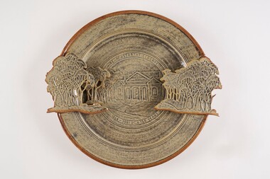 City of Greater Bendigo - Civic Collection
Decorative object - Ceramic platter, Bendigo Pottery, Strathfieldsaye Shire 1866 - 1991, 1991
... surviving public buildings. Designed by George Steane and built... surviving public buildings. Designed by George Steane and built ...Graham Masters is a potter based at Sweenies Creek, just outside Bendigo, Victoria who specialises in a patented technique of low relief stoneware depicting Australian animals and landscapes. He obtained a Diploma of Art and Design in Ceramics from the Bendigo Institute of Technology in 1973, then operated a pottery for a year in Bendigo, before becoming an employee, then a partner at Maldon Pottery, Victoria with Neville Wilson and Thomas Metcalf. He left Maldon to set up his own pottery at Sweenies Creek in 1984. (1.) (Judith Pearce). Built in 1869, the (former) Strathfieldsaye Shire Hall is one of The City of Bendigo's earliest surviving public buildings. Designed by George Steane and built by George Pallett in 1869 the Strathfieldsaye Shire Hall has aesthetic significance as a purpose built Shire Hall designed in the Free Classical manner. It is also of importance as an early example of the novel system of cavity wall construction. The building is largely intact and unaltered. Other important elements include the arched portico of the main entrance with brick arched features on either side; the brick quoining and dressings to the round arch windows; the three gabled roof; and the matching chimneys that reinforce the symmetrical design. The Hall has social significance as a temporary schooling facility in the 1870s and as a flood refuge in 1889. The Strathfieldsaye Shire Hall is a brick building designed in the Free Classical manner. This style was favoured by the Public Works Department for a number of public buildings including Shire Halls and courthouses. The form includes a central taller volume flanked by matching smaller gables. In the case of the Shire Hall these would be occupied by the Shire Secretary and Shire Engineer whilst the larger volume was the council chamber. The portico at the front is designed with a flat arch in the centre and matching smaller arches each side. The face red brick is unadorned apart from a plain string course at the roof springing point, brick quoining and dressings to the round arch windows. There are matching chimneys that are located to reinforce the symmetrical design and the original roof is believed to have been slate but is now corrugated iron. Large wheel thrown ceramic platter with a shallow well, broad flaring ledge and raised on a high foot rim. Rim decorated with slab rolled gum trees protruding on centre left and right sides of plater. which reflect the low relief image of trees and the Strathfieldsaye Shire Hall on the surface of the plate. Glazed with golden brown and cream. Front centre top; 'Shire of Strathfieldsaye'. Front lower centre '1866 - 1991 - 125 Years'. Signed 'G Master / 1991' on rim centre right. Reverse; signed 'G Master' / 1991. Bendigo Pottery stamp.shire of strathfieldsaye, bendigo pottery -
 Parks Victoria - Point Hicks Lightstation
Desk
... of Victoria’s major public buildings and other infrastructure including... major public buildings and other infrastructure including ...The large cedar desk was formerly used by the head light keeper at Point Hicks. It was made in the nineteenth century, probably by the Victorian Public Works Department (PWD) as an item of standard issue for use in government offices. The PWD operated in Victoria from 1855 to 1987 and was responsible for the design of Victoria’s major public buildings and other infrastructure including the supply of stores, furniture and equipment.The desk has turned legs, leather top and two drawers each with a pair of wooden knob hand pulls and is identical to the large desk remaining at Cape Nelson. A smaller version is at Cape Schanck, and another desk formerly at Cape Schanck is not able to be located. Gabo Island has a small cedar desk or table in the same style. Two sides of the Cape Schanck desk are stamped with the crown motif and monogram of the PWD but it is not known if the Point Hicks desk and the other nineteenth century examples are stamped with these details. There are also c.mid-twentieth century desks remaining in the collections at Wilsons Promontory and Gabo Island. officeThe Point Hicks desk has first level contributory significance for its historic values as government issued furnishing that is original to lightstation’s head keeper’s. Early, large two drawer cedar desk. Each drawer has two wooden handles. Leather insert on top of desk is worn. Commonwealth of Australia, Dept of Transport stamp with stock number on side of desk.On label on side, "C. of A. / D. O. T. / 143581" -
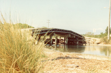 Lakes Entrance Historical Society
Photograph - Bridges, Fish Marie, 1965
... Entrance to Bullock island, which was built for Public Works Dept... for Public Works Dept. groyne building and sand build up to enlarge ...Also one other photograph, similar viewColour photograph of the first road bridge from Lakes Entrance to Bullock island, which was built for Public Works Dept. groyne building and sand build up to enlarge the island. Built early 1953. Lakes Entrance Victoria topography, bridges, islands, public works -
Glenelg Shire Council Cultural Collection
Certificate - Certificate - Historic Buildings, Portland Town Hall, 1974
... of public buildings in Portland and an interesting example... following a competition and subsequent public controversy over ...From the Victorian Heritage Register: The foundation stone of the original Portland Town Hall was laid by William Learmonth on 21st September, 1863 following a competition and subsequent public controversy over the permitted entry of architect John Barrow. The conservative classical design of municipal surveyor Alexander Ross was preferred and this axially planned design with central council chamber and side offices fronted by a fine axed pedimented gable entablature of basalt and Tuscan Doric pilasters was completed by 24th may 1864. The old Town Hall is one of a distinguished group of public buildings in Portland and an interesting example of conservative classical architecture of the first years of settlement in western Victoria. The basalt structure was partially erected of stone from the Portland stockade and has significant historical associations with local Government administration in the district. The Town Hall is the most impressive work of Alexander Ross, a surveyor architect whose career remains largely undocumented. The old Town Hall at Portland has been discreetly extended at the rear to provide additional meeting room accommodation. The premises are no longer used for local government administration.A4 sized certificate demonstrating Portland Town Hall's special significance to the state of Victoria & inclusion on the Historic Building Register. Singed by Robert Maclellan, Minister for planning & Historic Buildings Council Chairperson. Red seal attached, bottom right.portland town hall, history house, heritage register, historic buildings, certificate -
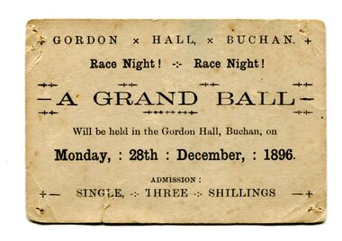 Orbost & District Historical Society
Document - ticket, 1896
... Gordon Hall was the first public building in Buchan... gippsland Gordon Hall was the first public building in Buchan ...Gordon Hall was the first public building in Buchan. European settlement first entered the area in October 1838 and Buchan station was established in January 1839. Free selection after 1868, and a township was proclaimed in 1873 taking its name from the station. The Grand ball was held on race night, Monday 28th December 1896 in the Gordon Hall at Buchan. From the estate of Elsie Cooke. Elsie Cooke was a librarian in Orbost for many years. She was the daughter of John Cooke early Brodribb settler. Elsie Cooke lived all her life in Gippsland,. She was born at Brodribb in 1895 and died in 1970, Elsie Cooke lived at Bruthen for a short time and, in 1937, moved to live with her aunt, Miss Jean Munro. Miss Cooke was Librarian at the Mechanics Institute for many years. Kindness and consideration for other were Miss Cooke’s attributes and she endeared herself to all who knew her. She was a loyal member of the Presbyterian Church and a stalwart of the Ladies’ Guild, an energetic worker for the Municipal Auxiliary and a member of the Red Cross. (ref. Mary Gilbert)This item reflects the recreational / social activities of a remote rural community. A public event such as a grand ball would have been a significant event on the calendar.Small, cream-coloured rectangular card with rounded edges and blank ink. Evidence of pin holes in each four corners and folds/signs of wear. Card is foxing and has small vertical tear in lower left quadrant.+ GORDON x HALL, x BUCHAN. + / Race Night! - Race Night! / A GRAND BALL / Will be held in the Gordon Hall, Buchan, on / Monday, : 28th : December, : 1896. / ADMISSION : / +- SINGLE, THREE SHILLINGS -+grand ball, 1896, gordon hall, buchan, elsie cooke -
 Kew Historical Society Inc
Plan, Melbourne & Metropolitan Board of Works. Borough of Kew Detail Plan No.1579, 1904
... ), weatherboard constructions (yellow), and public buildings (grey... (yellow), and public buildings (grey). While MMBW Plan No.1579 ...The Melbourne and Metropolitan Board of Works (MMBW) plans were produced from the 1890s to the 1950s. They were crucial to the design and development of Melbourne's sewerage and drainage system. The plans, at a scale of 40 feet to 1 inch (1:480), provide a detailed historical record of Melbourne streetscapes and environmental features. Each plan covers one or two street blocks (roughly six streets), showing details of buildings, including garden layouts and ownership boundaries, and features such as laneways, drains, bridges, parks, municipal boundaries and other prominent landmarks as they existed at the time each plan was produced. (Source: State Library of Victoria). This plan forms part of a large group of MMBW plans and maps that was donated to the Society by the Mr Poulter, City Engineer of the City of Kew in 1989. Within this collection, thirty-five hand-coloured plans, backed with linen, are of statewide significance as they include annotations that provide details of construction materials used in buildings in the first decade of the 20th century as well as additional information about land ownership and usage. The copies in the Public Record Office Victoria and the State Library of Victoria are monochrome versions which do not denote building materials so that the maps in this collection are invaluable and unique tools for researchers and heritage consultants. A number of the plans are not held in the collection of the State Library of Victoria so they have the additional attribute of rarity.Original survey plan, issued by the MMBW to a contractor with responsibility for constructing sewers in the area identified on the plan within the Borough of Kew. The plan was at some stage hand-coloured, possibly by the contractor, but more likely by officers working in the Engineering Department of the Borough and later Town, then City of Kew. The hand-coloured sections of buildings on the plan were used to denote masonry or brick constructions (pink), weatherboard constructions (yellow), and public buildings (grey). While MMBW Plan No.1579 does not include many buildings, those that it does show are significant to Kew’s history. These include the ‘Kew [Railway] Station’ in Denmark Street and the ‘Recreation Hall’ and rear courts off Wellington Street. The plan shows the outline of the Recreation Hall, constructed in 1880, at the rear of which is listed a bowling green, two tennis courts, a ‘skittle alley’ and a pavilion. When the Hall was first built, the Kew Cricket Club occupied an adjacent ground, however in 1885 this was acquired by the State Government as the future location of the Kew Railway Station. The Plan also shows a single oval at Xavier College. This oval was completed in 1883. One of the current ovals conforms to this oval’s original shape and position in the school grounds.melbourne and metropolitan board of works, detail plans, maps - borough of kew, mmbw 1579, cartography -
 Kew Historical Society Inc
Plan, Melbourne & Metropolitan Board of Works / Borough of Kew, Detail Plan No.1593, 1905
... ), weatherboard constructions (yellow), and public buildings (grey...), weatherboard constructions (yellow), and public buildings (grey ...The Melbourne and Metropolitan Board of Works (MMBW) plans were produced from the 1890s to the 1950s. They were crucial to the design and development of Melbourne's sewerage and drainage system. The plans, at a scale of 40 feet to 1 inch (1:480), provide a detailed historical record of Melbourne streetscapes and environmental features. Each plan covers one or two street blocks (roughly six streets), showing details of buildings, including garden layouts and ownership boundaries, and features such as laneways, drains, bridges, parks, municipal boundaries and other prominent landmarks as they existed at the time each plan was produced. (Source: State Library of Victoria)This plan forms part of a large group of MMBW plans and maps that was donated to the Society by the Mr Poulter, City Engineer of the City of Kew in 1989. Within this collection, thirty-five hand-coloured plans, backed with linen, are of statewide significance as they include annotations that provide details of construction materials used in buildings in the first decade of the 20th century as well as additional information about land ownership and usage. The copies in the Public Record Office Victoria and the State Library of Victoria are monochrome versions which do not denote building materials so that the maps in this collection are invaluable and unique tools for researchers and heritage consultants. A number of the plans are not held in the collection of the State Library of Victoria so they have the additional attribute of rarity.Original survey plan, issued by the MMBW to a contractor with responsibility for constructing sewers in the area identified on the plan within the Borough of Kew. The plan was at some stage hand-coloured, possibly by the contractor, but more likely by officers working in the Engineering Department of the Borough and later Town, then City of Kew. The hand-coloured sections of buildings on the plan were used to denote masonry or brick constructions (pink), weatherboard constructions (yellow), and public buildings (grey). The laborious task of hand-tinting these Board of Works plans was not without hazards as is evidenced by Plan No. 1593. On the Plan, the original colourist spilt black and green ink, partially obscuring some parts. The most obvious casualty is ‘Clifton’ located on the corner of Cotham Road and Park Street [now Adeney Avenue]. Included in this Plan, and outlined in pink is that part of the section that the contracting engineer was tasked with completing. This included sewering on both sides of this part of Cotham Road, but excluded properties such as ‘Glendonald’ and ‘Monnington’. This area was to undergo a series of subdivisions including the ‘Clifton Estate’, which created housing lots on Adeney Avenue and Florence Avenue in 1916. The most notable occupant of Clifton was William Adeney [died 1893], a pioneer of Camperdown, after which Park Street was later renamed.melbourne and metropolitan board of works, detail plans, survey plans - borough of kew, mmbw 1593, cartography -
 Kew Historical Society Inc
Plan, Melbourne & Metropolitan Board of Works : Borough of Kew : Detail Plan No.1291, 1905
... ), weatherboard constructions (yellow), and public buildings (grey...), and public buildings (grey). A detail plan of part of Studley Park ...The Melbourne and Metropolitan Board of Works (MMBW) plans were produced from the 1890s to the 1950s. They were crucial to the design and development of Melbourne's sewerage and drainage system. The plans, at a scale of 40 feet to 1 inch (1:480), provide a detailed historical record of Melbourne streetscapes and environmental features. Each plan covers one or two street blocks (roughly six streets), showing details of buildings, including garden layouts and ownership boundaries, and features such as laneways, drains, bridges, parks, municipal boundaries and other prominent landmarks as they existed at the time each plan was produced. (Source: State Library of Victoria). This plan forms part of a large group of MMBW plans and maps that was donated to the Society by the Mr Poulter, City Engineer of the City of Kew in 1989. Within this collection, thirty-five hand-coloured plans, backed with linen, are of statewide significance as they include annotations that provide details of construction materials used in buildings in the first decade of the 20th century as well as additional information about land ownership and usage. The copies in the Public Record Office Victoria and the State Library of Victoria are monochrome versions which do not denote building materials so that the maps in this collection are invaluable and unique tools for researchers and heritage consultants. A number of the plans are not held in the collection of the State Library of Victoria so they have the additional attribute of rarity.Original survey plan, issued by the MMBW to a contractor with responsibility for constructing sewers in the area identified on the plan within the Borough of Kew. The plan was at some stage hand-coloured, possibly by the contractor, but more likely by officers working in the Engineering Department of the Borough and later Town, then City of Kew. The hand-coloured sections of buildings on the plan were used to denote masonry or brick constructions (pink), weatherboard constructions (yellow), and public buildings (grey). A detail plan of part of Studley Park bordered by the major streets of Hodgson Street, Stevenson Street and Studley Park Road. Included on the plan are a number of significant Studley Park mansions in existence at the beginning of the 20th century. The unnamed street shown in the middle of the plan is McEvoy Street. The most important house still extant is Campion House, formerly named Dalsraith [Dalswraith] and Glendalough, owned since the 1940s by the Society of Jesus. Campion House can be seen on the corner of Hodgson and Studley Park Road. Its stables at the rear of the block have now been incorporated into a contemporary residence. An interesting feature of the plan is the 1910 annotation by Ed Seitz, professional designing engineer. Is Seitz the contractor who modified the MMBW original?melbourne and metropolitan board of works, detail plans, mmbw 1291, cartography -
 Kew Historical Society Inc
Plan, Melbourne & Metropolitan Board of Works : Borough of Kew : Detail Plan No.1564, 1905
... ), weatherboard constructions (yellow), and public buildings (grey...), and public buildings (grey). In 1905, when Plan No.1564 was printed ...The Melbourne and Metropolitan Board of Works (MMBW) plans were produced from the 1890s to the 1950s. They were crucial to the design and development of Melbourne's sewerage and drainage system. The plans, at a scale of 40 feet to 1 inch (1:480), provide a detailed historical record of Melbourne streetscapes and environmental features. Each plan covers one or two street blocks (roughly six streets), showing details of buildings, including garden layouts and ownership boundaries, and features such as laneways, drains, bridges, parks, municipal boundaries and other prominent landmarks as they existed at the time each plan was produced. (Source: State Library of Victoria)This plan forms part of a large group of MMBW plans and maps that was donated to the Society by the Mr Poulter, City Engineer of the City of Kew in 1989. Within this collection, thirty-five hand-coloured plans, backed with linen, are of statewide significance as they include annotations that provide details of construction materials used in buildings in the first decade of the 20th century as well as additional information about land ownership and usage. The copies in the Public Record Office Victoria and the State Library of Victoria are monochrome versions which do not denote building materials so that the maps in this collection are invaluable and unique tools for researchers and heritage consultants. A number of the plans are not held in the collection of the State Library of Victoria so they have the additional attribute of rarity.Original survey plan, issued by the MMBW to a contractor with responsibility for constructing sewers in the area identified on the plan within the Borough of Kew. The plan was at some stage hand-coloured, possibly by the contractor, but more likely by officers working in the Engineering Department of the Borough and later Town, then City of Kew. The hand-coloured sections of buildings on the plan were used to denote masonry or brick constructions (pink), weatherboard constructions (yellow), and public buildings (grey). In 1905, when Plan No.1564 was printed, that part of Kew bordered by Brougham Place (now Daniell Place), Mount Street, Sackville Street and Ross Street was already the location of a number of large mansions. Here, subdivisions, at least at this stage, produced larger blocks than in Central Kew. Many of the houses on this plan are named: ‘Faybrook’, ‘Northumbria’, ‘Parkholm[e]’, ‘Dunboe’, ‘Katoomba’ and ‘Eschol’ fronting Sackville Street. Eschol was once the home of the manufacturer Robert Harrison, whose cordial factory in Spring and Argyle Streets Fitzroy are noted on the Victorian Heritage Register. ‘The Hawthorns’ on the corner of Brougham Place and Mount Street was the home of the medical practitioner Frank William Fay, who won the military cross and other honours for conspicuous gallantry and devotion to duty in World War 1.melbourne and metropolitan board of works, detail plans, mmbw 1564, cartography -
 Kew Historical Society Inc
Plan, Melbourne & Metropolitan Board of Works : Borough of Kew : Detail Plan No.1570, 1905
... ), weatherboard constructions (yellow), and public buildings (grey...), and public buildings (grey). Plan No.1570 shows the layout ...The Melbourne and Metropolitan Board of Works (MMBW) plans were produced from the 1890s to the 1950s. They were crucial to the design and development of Melbourne's sewerage and drainage system. The plans, at a scale of 40 feet to 1 inch (1:480), provide a detailed historical record of Melbourne streetscapes and environmental features. Each plan covers one or two street blocks (roughly six streets), showing details of buildings, including garden layouts and ownership boundaries, and features such as laneways, drains, bridges, parks, municipal boundaries and other prominent landmarks as they existed at the time each plan was produced. (Source: State Library of Victoria)This plan forms part of a large group of MMBW plans and maps that was donated to the Society by the Mr Poulter, City Engineer of the City of Kew in 1989. Within this collection, thirty-five hand-coloured plans, backed with linen, are of statewide significance as they include annotations that provide details of construction materials used in buildings in the first decade of the 20th century as well as additional information about land ownership and usage. The copies in the Public Record Office Victoria and the State Library of Victoria are monochrome versions which do not denote building materials so that the maps in this collection are invaluable and unique tools for researchers and heritage consultants. A number of the plans are not held in the collection of the State Library of Victoria so they have the additional attribute of rarity.Original survey plan, issued by the MMBW to a contractor with responsibility for constructing sewers in the area identified on the plan within the Borough of Kew. The plan was at some stage hand-coloured, possibly by the contractor, but more likely by officers working in the Engineering Department of the Borough and later Town, then City of Kew. The hand-coloured sections of buildings on the plan were used to denote masonry or brick constructions (pink), weatherboard constructions (yellow), and public buildings (grey). Plan No.1570 shows the layout of gardens and houses in Sackville Street, Davis Street, Wrixon Street, and Fitzwilliam Street in 1904. While Thomas Street is included on the map, at this stage no houses had been built. The plan identifies two named houses: ‘Fairview’ and ‘Kylemore’. Fairview is more fully delineated in Plan No.1563. Kylemore is one of the few houses in Kew designed by John Beswicke. The most notable owner of Kylemore was William Whitehead, who owned the house between 1895 and 1900. In 1894, Australian newspapers reported the marriage of Whitehead’s daughter to Dr. Gerald Eugene Cussen, the brother of Sir Leo Cussen, the Supreme Court Judge. The married couple was to live at ‘Wilton’ (now the Kew RSL) from 1911-15.melbourne and metropolitan board of works, detail plans, mmbw 1570, cartography