Showing 1340 items
matching victorian maps
-
 Kiewa Valley Historical Society
Photograph Farm Land, Mount Beauty Acreage before Golf Course, Circa 1950
This photograph is a "snap shot" in time circa 1950s detailing the rural environment before the effects of the Kiewa Valley Hydro Scheme altered the basic rural setting of the valley. The golfing fairway was being mapped out on previous grazing land, before the laying of a golf course, for use by the construction workers and auxiliary administration employees of the Victorian State Electricity Commission. This photograph details a dramatic period in time which saw an enormous change to the exclusively rural area of the Kiewa Valley region in the mid 1900s. This change presented both physical and mental challenges to the existing quiet rural inhabitants of the valley. The State of Victoria had to make adjustments to the changing demands imposed by population and industrial expansions. The development of cleaner energy supplies to a growing population has its downside ,which ever way the intrusion into the "natural" landscape is made.Black and white photograph detailing surveyor posts for construction of golf course. Land used, before establishment of the Mount Beauty Village, as farming/grazing cattle and viewed towards Mount Bogong and its Alpine ranges. The photo is on 200gms paper and not on photographic paper.nilmount beauty in the 1940s - 1950s, grazing in the kiewa valley, sec victoria -
 Kiewa Valley Historical Society
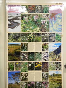
Map / Chart, Vegetation Map & Guide to Alpine Flora: Pretty Valley, 1982
This poster shows Pretty Valley is on the Victorian High Plains where the State Electricity Commission of Victoria worked on the Kiewa Hydro Scheme. Also cattle have grazed in the area over the years. This map is of interest to compare the flora in the area with times prior to 1982 and after 1982.This poster has historical and research value as it shows the flora in the pretty valley area therefore making it significant for people interested in plants. Also for those who would like to compare what plants are still in this area after 1982 and if the cattle grazing, climate change, of bush fires have had on the environment. Thus this poster also has good interpretive capacity of these reasons. Laminated double sided vegetation map and photographic guide to Alpine flora of the Pretty Valley areapretty valley. bogong. vegetation. plants. flowers. alpine. victorian high plains. cattle grazing. s.e.c.v. -
 Kiewa Valley Historical Society
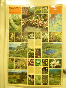
Map / Chart, Vegetation Map & Guide to Alpine Flora: Hotham, 1982
This poster shows Mt Hotham is on the Victorian High Plains. This poster and map enables the comparison to be made of flora in other areas of the Victorian High Plains e.g.. which was previously known as the Bogong High Plains. This poster has historical and research value as it shows the flora in Mt Hotham area therefore making it significant for people interested in plants. Also for those who would like to compare what plants are still in this area after 1982 and if the cattle grazing, climate change, of bush fires have had on the environment. Thus this poster also has good interpretive capacity of these reasons.Laminated double sided vegetation map and photographic guide to Alpine flora of the Hotham area.hotham. vegetation. plants. flowers. alpine. high plains of victoria. -
 Kiewa Valley Historical Society
Map / Chart, Vegetation Map & Guide to Alpine Flora: Rocky Valley, 1982
This poster is of Rocky Valley is on the Victorian High Plains where the State Electricity Commission of Victoria worked on the Kiewa Hydro Electric Scheme and also where cattlemen brought their cattle up during summer at various times. Its significance is due to it shows the flora of the area after the Kiewa Hydro Electric Scheme Rocky Valley damn has been build and therefore is a valuable for comparison to see what plants are there now after this information on this poster was complied. Historic: Comparison of the flora at Rocky Valley with other areas on the Victorian High Plains and with Rocky Valley before and after the Kiewa Hydro Scheme and / or grazing there. Is therefore research significance and interpretive capacity due to this compatibility value.Laminated double sided vegetation map and guide to the Alpine flora of the Rocky Valley area, with photographs of plants and vegetation.rocky valley. alpine. flora. vegetation. plants. s.e.c.v.. cattlemen. victorian high plains. -
 Kiewa Valley Historical Society
Folder - Mt Beauty Album, Premier Town Competition Mt Beauty July 1958
Mt Beauty & District Progress Association was formed when people of the Kiewa works system was to become a rate paying society no longer dependent on the State Electricity Commission of Victoria. 30 community members met on 4th December 1957 to form the new organisation.Mt Beauty and District Progress Association represented, protected and guided the community in arrangements for the future. The Association became more than a Chamber of Commerce. It represented a wide range of interests, a strong voluntary labor force largely responsible for the development of many of the on-going organisations It encompassed and set a strong program for tourism seen as being the security guarantee of the future. This was realised when Mt Beauty won The Victorian Premier Town contest in 1958. Thick brown cardboard cover with two steel rings for all 10 Appendix pages attached. The first section is not attached but inserted. This section with its own brown cardboard cover and bound by steel attachment, consists of the Application from the Mt Beauty & District Progress Association, July 1958 totalling 50 pages.The appendixes are labelled by number and have the relevant document(s) inside eg. mapsalex mccullough, mt beauty & district progress association, the victorian premier town -
 Kiewa Valley Historical Society
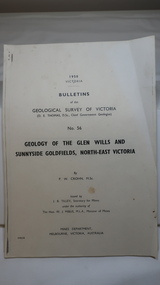
Document - Four Geological reports on the North-east Goldfields, Geological Survey of Victoria 1958 Bulletin
Geological Surveys of N.E. Goldfields Victoria included mines and tunnels. A resurvey of goldfields was necessary to re-assess economic possibilities using modern techniques and structural interpretation. It included an examination of a considerable surface area with maps and underground workings. Results were correlated and integrated and published by the Mines Department.The mines are in the Bogong Alpine Area.Foolscap printed Victorian Bulletins. Each stapled in the top left corner and each with varying number of pages. Covering 1941-1958 a) Glen Wills and Sunnyside b) Sunnyside Tunnel c) Red Robin d) Maud and Yellow Girl Government Printer, Mines Department, Melbourne, Victoriageology in the north-east, gold fields, goldmines, glen wills -
 Kiewa Valley Historical Society
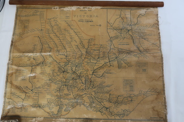
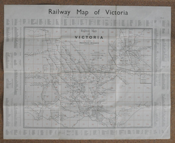
Map - Railway Map of Victoria, Amended to 1/11/1945
Railways began in the 1850s and were privately owned and operated. Later they were taken over by the Victorian Government reaching a peak in the early 1940s.Steam trains were followed by electric trains with both running after the war in 1945.Bright was the closest station to the Kiewa Valley but road transport was used more often as the Kiewa Valley Highway was improved with the construction of the Kiewa Hydro Electric Scheme. To travel to Melbourne or Sydney by train residents went via Wodonga/Albury where they also did their shopping.Plastic on parchment with detailed railway routes (in green) across Victoria including each district's 'Road Foremen' and 'Depots'. There is a length of flat wood attached by 10 tacks across the top of the mapvictorian railways 1945, trains, transport -
 Kiewa Valley Historical Society
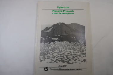
Book - Book - Alpine Area - Department of Conservation, Forests & Lands, Alpine Area / Planning Proposals / a basis for management. 1987
It is the policy of the Government that most of the State's alpine area will be proclaimed as an Alpine National Park, which would complement the Kosciusko National Park in N.S.W.. This is yet to be achieved (1987), however there is a need for sound, efficient and coordinated management based on the area's natural features, values and uses. Planning is proceeding on this basis.Victoria's alpine area is one of the State's most outstanding and spectacular natural areas. It is noted for its diverse plant and animal life, scenery, recreation opportunities and as a water catchment. This country is at the upper end of the Kiewa Valley and the planning for it is of interest to the Kiewa Valley inhabitants.White bound book with green print for title at the top, black & white picture and black print at the bottom for the name of the government authority publishing the book.143 pages with fold out map after page 7. The map is coloured green to indicate the planning area.alpine area, bogong national park, victorian department of conservation forests & lands -
Kiewa Valley Historical Society
Ron White's Collection - 1920 - 2019
The State Electricity Commission of Victoria constructed the Kiewa Hydro Electric Scheme.See KVHS 1282Ron White was the Principal Hydro Engineer 1966 - 1985 on the Kiewa Hydro Electric Scheme. See KVHS 12821. Booklet "Rules of the Kiewa Hydro Co-operative Distribution Society Limited" and Ron's 'Share Certificate' dated 12th /4/1957 2. Book "Inside Information" explaining the ins and outs of a car for the motorist. 3. Black and White negatives 4. Ron's La Trobe Valley Health Services Membership card x2 5. State Savings Bank of Victoria Kiewa Operations social club 1962 x2 6. The Association of Professional Engineers, Victorian Branch receipts 1956 7. Upper Kiewa Valley Uniting Church list of members 1969-1970 & Financial Statement for 1970 8. 4 Bogong Village coloured postcards 9. Folded Plan of 'Kiewa Area Planimetric Map' 10. Large Photos sent to Ron by "Bill Greenaway / Y.T.S. Lab./ 11-5-66" 1) Football Team x2, 2) Mt Beauty Switchyard, 3) McKay Power Station, 4) Clover Power Stationron white -
 Eltham District Historical Society Inc
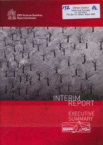
Book, Bushfires Royal Commission, 2009 Victorian Bushfires Royal Commission, Interim Report, Executive Summary, 2009
... Victorian bushfires ISBN 978192337765 26 p. : col. ill., maps ; 30 ...Interim report of Bushfires Royal Commission on the 2009 Victorian bushfires26 p. : col. ill., maps ; 30 cm.ISBN 978192337765 -
 Eltham District Historical Society Inc
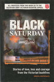
Book, Black Saturday : Stories of love, loss and courage from the Victorian bushfires edited by John McGourty, 2009
The Black Saturday bushfires were a series of bushfires that ignited or were burning across the Australian state of Victoria on and around Saturday, 7 February 2009 and were Australia's all-time worst bushfire disasters. Contributions from reporters and photographers from News Limited. The book is a collection of individual stories, featuring deeply personal contributions from: people directly affected by the bushfires, their friends and relatives; the people who came to their aid - fire fighters, doctors, nurses and wildlife rescuers; accounts from journalists on the scene; and those involved in coordinating the response. Arranged town-by-town, with introductions detailing the scope and impact of the fires on each community. Contents: Kilmore East & Wandong - Strathewen & Kinglake West - St Andrews & Steels Creek - Kinglake - Flowerdale - Marysville--Gippsland -Beechworth & Mudgegonga - the lost ( listing those who perished ) - map of tragedy. Proceeds from the sale of each book was given to the Salvation Army Victorian Bushfire Appeal.SoftcoverYarra Plenty Regional Library identification sticker with name, number and bar code ISBN 9780732290108strathewen, st andrews, black saturday, fires -
 Eltham District Historical Society Inc
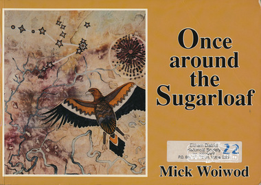
Book, Mick Woiwod, Once around the Sugarloaf : the transformation of a Victorian landscape and the story of its people / Mick Woiwod, 1992
Paperback; 301 p. : ill., ports., maps ; 21 x 30 cm.ISBN 0646106198 [signed by author on title page]sugarloaf mountain -
 Eltham District Historical Society Inc
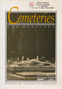
Book, Celestina Sagazio, Cemeteries : our heritage / edited by Celestina Sagazio, 1992
History of Victorian cemeteries; includes a chapter on Aboriginal mission cemeteries; guide to how to use cemeteries for research and family history and how to conserve cemeteries.Paperback; 184 p. : ill., 1 map ; 24 cm.ISBN 0909710856social customs, cemeteries, healesville, victoria, aborigines, st helena, greensborough -
 Eltham District Historical Society Inc
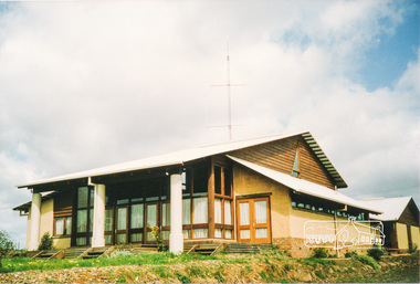
Photograph, Emergency Operations Centre, S.E.S., Kangaroo Ground
In 2017 known as the Kangaroo Ground Operations Centre a facility for hire managed by the Shire of Nillumbik. On 7 February 2009 (Black Saturday) the CFA Incident Control Centre (ICC) was located here. Described in "Worst of Days: Inside the black Saturday firestorm" by Karen Kissane (access via Google books): "..the ICC is part of a mud brick complex built in the 1980s as an emergency operations centre for several agencies, including the State Emergency Service. It is also home to the headquarters of the CFA's Lower Yarra Group. A small office with a whiteboard would be the incident controller's office throughout the office, but a larger central room, with data projectors, "smart boards" and maps would house the rest of the team.."Statement of Significance From the Victorian Heritage Database (2010) What is significant? The 1988 emergency operations centre and the surrounding site to the title boundaries. How is it significant? The emergency operations centre is architecturally, aesthetically, socially and historically significant to the Shire of Nillumbik. Why is it significant? The emergency operations centre is architecturally and historically significant as a good and rare example of a large public building constructed in a 1980s version of the 'Eltham style', and as a rare attempt to adapt the 'Eltham-style' aesthetic to meet the changing demands of the Shire in the 1980s (Criteria B, D & E). The emergency operations centre is architecturally and aesthetically significant because it is constructed of mud brick and features: a central entry with a tile mural (Criterion E). The emergency operations centre is socially significant because it is a focal point for the community and has played an important role in protecting the community since 1988 (Criterion G).Two colour photographs of mud brick Emergency Operations Centre building, Kangaroo Groundbuildings, mud brick, emergency centre, kangaroo ground -
 Warrnambool and District Historical Society Inc.
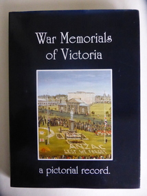
Book, War Memorials of Victoria, 1994
This book gives information on 1,100 War Memorials in Victoria. It was compiled by Bradley, Christey et al and produced for the Returned and Services League of Victoria. War Memorials were established in most settlements in Australia after World War One and added to after World War Two and succeeding conflicts. The number of War Memorials reflect the historical importance of Australia’s involvement in world wars and because of our distance from the battlefields they have become sacred places in Australia – de facto war cemeteries. The book includes information on the Warrnambool War Memorial and those in our area. This book is of interest as it gives details on War Memorials and includes all those in the Western District of Victoria. It will be useful to researchers of social and military history. This is a hard cover book with a blue cover and gold printing on the spine. The dust cover is dark blue with a colour sketch of the Portland War Memorial and white printing on the front cover and an outline of the map of Australia on the back cover. The book has 240 pages, black and white and colour illustrations, a Foreword, Dedication, Acknowledgements, Introduction, Contents, Bibliography and Index and information in alphabetical order of the War Memorials in Victoria. It also has reproductions of 20 oil paintings of Victorian War Memorials by Dacre Smyth.Spine: ‘War Memorials of Victoria’ R.S.L. Victorian Branch’ Front Cover: ‘War Memorials of Victoria, a Pictorial Record’ war memorials in victoria, warrnambool war memorial, history of warrnambool -
 Warrnambool and District Historical Society Inc.
Booklet, Victorian Almanacs, 1860s
These Victorian Almanacs were published from 1859 to 1916. They contained information of interest to all Victorians, especially historians, businessmen, farmers and gardeners and must have sold many copies in Warrnambool, particularly before the local Warrnambool Standard Almanacs began publication in 1875. These booklets are of interest as examples of 19th century almanacs published in Victoria. They are also somewhat similar to the Almanacs published annually by the Warrnambool Standard newspaper from 1875 to 1930. The 1869 Almanac is of particular interest as it has on the front cover the printed name of James Hider, stationer and bookseller of Warrnambool. James Hider had been a carpenter, a land agent and a rate collector before opening a shop in Timor Street, selling books and stationery and operating a Circulating Library. In 1865 Hider set up as a photographer and was still operating this business in 1878. He was active in community organizations, including the Mechanics Institute, the Fire Brigade, the National School, the Musical Group and the Benevolent Society. He was also a Councillor and a Mayor in the 1860s. It is interesting to note that his name does not appear to have been been added to the 1869 Almanac cover but is part of the original printing. These are two soft cover booklets of 60 pages each. The back covers of both are missing and the 1868 booklet has some back pages missing. The 1868 Almanac has a black and white cover with ornamental scrolls and the 1869 booklet has a red, green black and cream cover with an ornamental border and images of flora and fauna. The 1869 Almanac cover has a Coat of Arms with Advance Australia printed at the bottom of it. The 1869 Almanac also has a map of Victoria as an insert. Both almanacs contain an historical calendar, Victorian Parliamentary information, data on Victorian cities, postal regulations, farmers’ and gardeners’ guides etc. Both contain advertisements relevant to Melbourne. Both have been bound with string. victorian almanacs, annual journals, james hider, bookseller and stationer,, warrnambool. -
 Warrnambool and District Historical Society Inc.
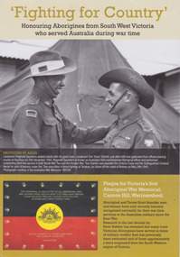
Booklet, 'Fighting for Country' Honouring Aborigines from South West Victoria who served Australia during war time, February 2014
This booklet was collated and printed for the 2014 Lake Bolac Eel Festival, ‘Return to Country’. The author, Peter Bakker, has spent several years researching the part played by south western Victorian aborigines and this booklet details the results of this research. Several of the soldiers came from the Warrnambool area.This is a booklet of ten pages with printed material and black and white and colour photographs and a map.Front Cover: ‘Fighting For Country – Honouring Aborigines from South West Victoria who served Australia during War Time’ (plus other printed material) Back Cover: Map and List of Service Men and Women of Aboriginal Descent with connections to South West Victoria aborigines from south west victoria, return to country, lake bolac eel festival, peter bakker, world war one, world war two, korean war, vietnam war -
Ringwood and District Historical Society
Badges, Badges and Coins 1939-45: 50 years of Queen Victoria's Reign; ANZAC Pins, King George and Queen Elizabeth; City of Wangaratta; etc, 1939 - 1945
Many issues - ANZAC DayBadges and coins. Refer photograph. +Additional Keywords: Pratt, G / GibbonTop Row L_R:; Victoria - 50 Years of Reign. Diam 3cm.; RDFA/Time Keeper (2 badges); Plastic 7-pointed badge (2 badges): Palestine-Gallipoli, FRANCE, Egypt, Mesopotamia, North Sea, New Guinea. In Centre: Lest We Forget printed across a map of Australia.; Assorted ANZAC pins/badges (5 badges); Middle Row L-R:; Side 1: King George VI & Queen Elizabeth (5 badges); Side 2: City of Wangaratta. Wangaratta Proclaimed a City.; Bottom Row:; Royal Life Saving Society, Established 1891. Centre: Awarded to G. Gibbon 1945.; Awarded to G Pratt v 1945; Victorian Rifle Association (2 badges); Legacy Badges/Pins (2 badges); Map of Australia on metal pin; Badge: Side 1 Centenary of Victoria 1934. On undeveloped scene embossed)/ Side 2 Centenary of Victoria 1935. (On city skyline embossed) Diam 2.6 cm.; Pavilion Fund Bayswater 1947-1948 -
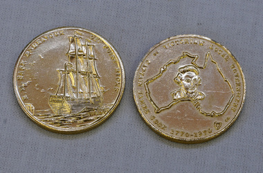 Orbost & District Historical Society
coins, Victorian Local Government, 1970
These coins were made as part of the 200 year celebration of Captain James Cook's voyage on the HM Endeavour and the first sighting of Australia at Point Hicks in 1770. These two coins were presented to Orbost Historical Society by the Orbost Branch of the Bank of New South Wales in 1970.These coins were made as part of the 200 year celebration of Captain James Cook's voyage in 1770 and reflect the importance of that historic event.Two silver coloured coins. On one face is the image of a sailing ship and the words HM BARK ENDEAVOUR OFF POINT HICKS and on the other face is a map of Australia with a head portrait of Capt. Cook in its centre, and the words CAPTAIN JAMES COOK 1770-1970 VICTORIAN LOCAL GOVERNMENT around the edge.as abovecoins celebratory-coins captain-cook australia-discovery -
 Ringwood and District Historical Society
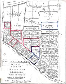
Map, The East Estate, Township of Ringwood, Victoria - 1927
Photocopied page - partial Parish map of Ringwood labeled The East Estate, showing street names and properties marked with names of individual owners or businesses.Page titled The East Estate by 1927 Part of Township of Ringwood, Parish of Ringwood, County of Mornington, Scale: Four Chains to One Inch. L.F. East blocks are marked by red outline. J. Blood blocks are marked by blue outline. Other names include B.C. Hutchinson & Co., The Victorian Brick & Ornamental Tile Coy., Ltd., The Ringwood Brickmaking Coy., Ltd., R. Davidson, J. Williamson, W.E. Bower, H. Jennings, G.J. Sims, J. Smallman, J. Horne, J. Lindsay, J. Kay, H. Unverhan, B.C. Hutchinson, M.A. Williamson, J.S. Woodworth, J. Price, C. Medew, S.W. Burchett, B.J. Hosking, D.J. Rogers, C. Wheeler, H. Frost, G.G. Miller, L. Winchcombe. Streets include Dublin Road, Illoura Road, Alexandra Road, and Bedford Road. -
 Ringwood and District Historical Society
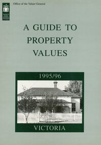
Book - Collection, Valuer General of Victoria, Guide to Property values in Victoria 1988-2006 (16 volumes), 1988-2004
part of the Richard Carter CollectionCollection of 16 books from the Office of the Valuer general with data and analysis of property values in Victoria by City and by Shire. With maps of local government. 1988-1994 A4 in size reducing to a slightly smaller size 1996-2006. Originals not kept - only scanned pages of City of Ringwood and Maroondah City Council PDFed. Refer to Victorian Government websites (www.land.vic.gov.au, www.consumer.vic.gov.au and others for Excel downloads and further details. -
 Orbost & District Historical Society
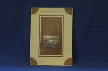
book, Our First 50 Years, 1985
This is a souvenir edition - a reproduction of a section of an old three volume geographic encyclopaedia of Australia and New Zealand published in 1885.This book is a useful reference tool for the early history of Victory.A reproduction of a book first published in 1885. The soft cover is brown, a paler brown background and gold coloured text - Victorian Souvenir Edition Our First 50 Years. 1835 1885 is inside 50. There is a sketch of the "Lady Nelson" entering Port Phillip. It has 162 pp which are sepia toned in double columns with illustrations and maps throughout the book .history-victory book -
 Orbost & District Historical Society
book, Vic Roads Centenary 1913 -2013, 2013
The publication, VicRoads Centenary: Keeping Victorians Connected for 100 Years, looks at the people and projects that define VicRoads’ history. Written by current and former VicRoads’ employees, the publication details the organisation’s portfolio of major projects, which includes the Great Ocean Road, Hume Highway and Eastern Freeway. Other sections report on Victoria’s world-first road safety initiatives, VicRoads’ use of technology and sustainability measures. (ref VicRoads) This item is one of several books donated by David Jellie at a presentation to Orbost Historical Society. He was a contributor to the book and was the engineer for the Snowy River Bridge (Princes Highway) at Orbost 1974-1976.This book is a useful reference tool on the history of road construction in Victoria including East Gippsland.A thick, bound paperback book, titled "VicRoads Centenary Keeping Victorians Connected for 100 Years". On the front cover is a black/white photograph of two men working on a road. One has a pick. The book contains the history of VicRoads, photographs, maps and advertisements. Some are b/w. Others are coloured.vicroads book roads snowy-river-bridge jellie-david -
 Orbost & District Historical Society
map, Railway Map of Victoria, 1.8.1965
... map-railway Victorian-Railways...-railway Victorian-Railways A large rectangular shaped paper map ...The Bairnsdale-Orbost railway was opened in 1916 to serve the agricultural and timber industry. Because of the decline in traffic and heavy operating costs, the line was finally closed in August, 1987.This item is associated with the history of the Orbost-Bairnsdale railway line and therefore reflects the role that the rail line played in the social and economic history of Orbost.A large rectangular shaped paper map of all railway stations in Victoria. It is dated 1st August 1965. It is divided into grids. Stations are listed around the map. A key is provided and each station has a grid reference.map-railway victorian-railways -
 Glen Eira Historical Society
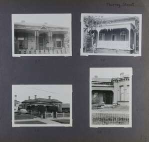
Album - Album page, Murray Street, Circa 1972
This photograph is part of the Caulfield Historical Album 1972. This album was created in approximately 1972 as part of a project by the Caulfield Historical Society to assist in identifying buildings worthy of preservation. The album is related to a Survey the Caulfield Historical Society developed in collaboration with the National Trust of Australia (Victoria) and Caulfield City Council to identify historic buildings within the City of Caulfield that warranted the protection of a National Trust Classification. Principal photographer thought to be Trevor Hart, member of Caulfield Historical Society. Most photographs were taken between 1966-1972 with a small number of photographs being older and from unknown sources. All photographs are black and white except where stated, with 386 photographs over 198 pages. Houses shown at 35, 58 and 32 Murray Street Elsternwick are still all extant (Google map image capture Dec 2018). Victorian Heritage Database - HO130 32 Murray Street Caulfield https://vhd.heritagecouncil.vic.gov.au/places/35535 (at 14/08/2021) No. 32 Murray Street is locally distinguished as the most imposing villa of its period in Murray Street whilst its association with J. W. Doyles, builder of several houses in the same street, is of interest. Its importance is enhanced by its substantially intact state.Page 138 of Photograph Album with four photographs (three landscape, one portrait) of 3 different houses on Murray Street. Handwritten: Murray Street [top right] / 35 [under top left photo] / 58 [under top right photo] / 32 [under bottom left photo] / 32 [under bottom right photo] / 138 [bottom right]trevor hart, garden, verandah, murray street, elsternwick, victorian style, houses, cast iron work, bay windows -
 Glen Eira Historical Society
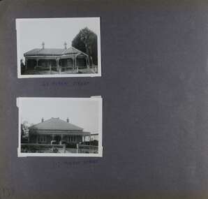
Album - Album page, Murray Street, Circa 1972
This photograph is part of the Caulfield Historical Album 1972. This album was created in approximately 1972 as part of a project by the Caulfield Historical Society to assist in identifying buildings worthy of preservation. The album is related to a Survey the Caulfield Historical Society developed in collaboration with the National Trust of Australia (Victoria) and Caulfield City Council to identify historic buildings within the City of Caulfield that warranted the protection of a National Trust Classification. Principal photographer thought to be Trevor Hart, member of Caulfield Historical Society. Most photographs were taken between 1966-1972 with a small number of photographs being older and from unknown sources. All photographs are black and white except where stated, with 386 photographs over 198 pages. 63 and 117 Murray Street houses are extant (Google maps image capture Dec 2018).Victorian Heritage Database - HO131 63 Murray Street Caulfield https://vhd.heritagecouncil.vic.gov.au/places/35569 (as of 14/08/2021) "Marston" at no. 63 Murray Street, Caulfield South, was built by J.E. Guest, a contractor resident in nearby Downshire Road, in 1889-90, presumably as a speculative venture together with the extant house at adjoining No.61. It is aesthetically significant. It is aesthetically significant (Criterion E) as an exceptionally richly ornamented medium sized Boom period villa in Caulfield South, being unusual in this respect in its locale and comparing with nearby "Sprouston" at 19 Blanche Street (1887). Important contributory elements include the polychrome brickwork, frieze and verandah including the half timbered gablet which would have been stylistically innovative in its day.Page 139 of Photograph Album with two landscape photographs of two different houses in Murray Street. Handwritten: 63 MURRAY STREET [under top photo] / 117 MURRAY STREET [under bottom photo] / 139 [bottom left]trevor hart, garden, verandah, murray street, elsternwick, victorian style, houses, marston, house names, j e guest, verandahs, polychrome bricks, cast iron work, chimneys -
Glen Eira Historical Society
Article - OUTER CIRCLE RAILWAY
This file contains five items: 1/Two copies of a document titled THE OUTER CIRCLE RAILWAY by the Royal Historical Society of Victoria and the Australian Railway Historical Society, Vic div. It details the history of the construction of the Outer Circle Railway and discussed expenses and other factors affecting the construction of the line. Notes compiled by R.K Whitehead, Research and Archives Officer Australian Railway Historical Society Victoria Division. The document includes three maps of the outer circle railway line. 2/Four newspaper articles detailing the history of the Outer Circle Railway Line. They include ten black and white images of various aspects of the railway and three line maps. The first article is titled ‘Rail Link with the Past’. In the COLLINGWOOD COURIER dated 07/10/1970, author unknown. The second article titled ‘Ghost trains of the Outer’ by Kenneth Joachim in the HERALD dated 18/04/1975. The third article is titled ‘Tracks in Time’ by Norman Thompson from NEWS, dated 13/02/1973. The fourth article is titled ‘Our Ghost Railway’ by John Townsley from the HERALD, dated 06/11/1974. 3/A letter from Victorian Railways Chief Estate Officer N.A Wigmore to the Honorary Secretary of the Caulfield Historical Society, dated 19/11/1975 regarding the leasing of land along the Outer Circle Railway Reserve from Dandenong Road to the Hughesdale Station. 4/Two copies of an article titled ‘Outer Circle Railway’ in the CAULFIELD HISTORICAL SOCIETY NEWSLETTER undated detailing the history of the outer circle line. The article includes a map of the section of the line in Caulfield. 5/A Photocopy of two images of train line locations on the Outer Circle Line. One on Warrigal Road, looking south from Ashburton dated 1936. The second is of the Black Bridge over Gardiners Creek dated 1935.outer circle railway, normanby road, caulfield station, outer circle line, rosstown junction railway, monash john, caulfield historical society, poath road, deepdene dasher, ashby dasher, dandenong road, gippsy goods, mallee root mercury, outer circle railway reserve, railway lines, railway stations, steam trains -
Glen Eira Historical Society
Letter - Rosstown Railway
This file contains four items: 1/A black and white photocopy of a letter dated either 07/08/1889 or 09/08/1889, from Robert Lundon to an unidentified recipient discussing an agreement reached between the author – on behalf of the recipient – and Soon Hang Hi in regard, in regards to the allotment known as Webber’s. The agreement is outlined in the letter in what appears to be Chinese characters, and includes the marks of Robert Lundon and Soon Hang Hi. File note from Joy Wu states that the calligraphy is not Mandarin or traditional Chinese. 2/Three sheets of hand-written working notes with information taken from the Victorian Government Gazette on THE ROSSTOWN AND MURRUMBEENA LAND COMPANY LIMITED, THE ROSSTOWN JUNCTION RAILWAY AND PROSPERITY COMPANY LIOMITED, and THE ROSSTOWN JUNCTION, ELSTERNWICK, AND OAKLEIGH RAILWAY COMPANY LIMITED, covering dates between 1887 and 1894. The notes concern meetings and creditors claims relevant to the companies, with reference numbers for the information source. Date and author of the notes are not recorded. 3/A black and white photocopy of the a partial map of the Rosstown Railway and surrounding area, undated. The map includes the names of landholders in the areas of Brighton, Garden Vale and Elsternwick, as well as other railway lines present in the region. 4/A fold-out map and guide of the Rosstown Rail Trail, including a brief general history of Caulfield as well as a more extensive biography of William Murray Ross and the Rosstown Railway. The map marks and describes significant sites along the trail, including photographs of some of these sites, provided by DF Jowett.documents, correspondence, webber’s, lundon robert, chinese characters, ethnic communities, signatures, text, settlements, taxes, fraser john grieves, lovell r.h., price davies, meetings, communication activities, soon hang hi, commercial events and activities, the rosstown and murrumbeena land company limited, victorian government gazette, bulmer richard, parry john, osment henry, shareholders, creditors claims, the rosstown junction railway and property company limited, finch and best, lawyers, the rosstown junction elsternwick and oakleigh railway company limited, cameron w.c., phillips p.d., garden vale, elsternwick, elsternwick railway station, rosstown, rosstown railway, thomas street, bay street, kooyong road, melbourne and brighton railway, hawthorn road, bambra road, caulfield and frankston railway, booran road, grange road, koornang road, murrumbeena road, north road, north road railway station, east brighton railway station, south road, railway routes, railway lines, railways, land transport, murphy j., caulfield, hamilton t.f., dane p., holloway, webb, ailee john, payne t.b., brodie chas, dane john, o’neil h., mccombie john, mcmillane a., smyth c.d., cooper, ebden, landholders, jeffrey j.d., gill j., balcombe a.e., cooper h., mcnab j., white j., sutherland j., greeves a.f.a., newton m.c., chamley f.b., fowler j., inglis p., grant t., stooke j., swanson g., cochrane c., adams e.b., mccombie thas, keyes robert, brighton cemetery, burials grounds and graveyards, war-ein road, were j.b., holland j., mcmahon c., winter t.l.m., dendy henry, mitchell w., jackson s., were j.e., wickham francis dawe, bryant jane, east brighton railway station, railway stations, maps, allotments, land titles, roads and streets, rosstown rail trail, city of glen eira, tourism, trains, tourism information bureaus, tours, pamphlets, elsternwick railway park, oakleigh junction, princes park, ee gunn reserve, packer park, sites, jowett d.f., weickhardt i.g., return to rosstown: railways land sales and sugar beet ventures in caulfield, land sales, walking trails, ross william murray, transport objects, locomotion, walking, cycling, driving, sports, country mansions, people, caulfield john, builders, construction and demolition workers, occupations, careers, professionals, topography, geology, landforms, horticulture, market gardens, primary industry workers, city of caulfield, mood kee, pennington harold, annual general meetings, caulfield town hall, glen eira city council, carnegie, carnegie station, rosstown station, people by circumstance, migrants, sugar beet, sugar beet mill, sugar beet industry, mills, factories, sea beach lines, bent thomas, parliamentary representatives, neville street, miller street, lemann’s swamp reserve, koornang park, cane sugar industry, breweries, rabbit processing plants, health establishments, hospitals, food production establishments, abattoirs, thieves, social problems, vagrants, theft, squatting, financial economics, debt, finance industry, insurance companies, company managers, bentleigh, ross leila, the grange, leila road, wild cherry road, financial trouble, mortgages, gisborne street, archibald street, riddell parade, victoria railways, glen huntly road, clarence street, college street, gladstone parade, parrell street, aileen avenue, seaview street, drion estate, land subdivisions, dover street, sussex street, landfill, marara road, booran road, woodville avenue, dorothy avenue, ormond park, royal avenue, ormond railway station, oakleigh road, melten avenue, miller street, munro avenue, lord reserve, neerim road, toolambool road, the rosstown hotel, rosanna street, murrumbeena crescent, commercial establishments, the national bank, rosstown road, kangaroo road, poath road, freda street, hughesdale kindergarten, oakleigh council, hughesdale community centre, civic establishments, galbally reserve, plaques, warrigal road, out and about brochures -
Glen Eira Historical Society
Map - Victorian Railways
... System’ outlining fare structure. Stylised map of Caulfield (Glen ...This file contains three items. 1. Original railways grid map of Victoria with passenger mileages (in miles) which shows railway stations in Glen Eira as part of the rail network. 2. Original pamphlet titled ‘Pocket History Vicrail 1839 – 1981’, dated 1981. Chronological history of milestones and dates, ie. 1981 Caulfield loop opened 24/01/1981 as part of underground rail loop. Image on front cover shows 2 images (steam train and stainless steel train). 3. Original pamphlet by Ministry of Transport titled ‘Your neighbourhood Public Transport System’ outlining fare structure. Stylised map of Caulfield (Glen Eira) neighbourhood.carnegie, bentleigh, caulfield, elsternwick, glenhuntly, ormond, murrumbeena, railways, public transport, bus, train, tram, railway stations, ‘vicrail’, underground rail loop -
 Federation University Historical Collection
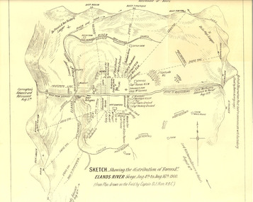
Plan, Sketch of Elands River Siege, 1900
... ://trove.nla.gov.au/ndp/del/article/11023251 boer war map sketch victorian's ...Plan based on the field notes of Captain David John Ham, V.B.C. For article written by Ham on the event, see http://trove.nla.gov.au/ndp/del/article/9542500 For obituary of Ham, see http://trove.nla.gov.au/ndp/del/article/11023251Sketched paper map of forces' distribution at the Elands River siege. Map details surrounding hills, roads, rivers, and names all soldiers involved in siege. boer war, map, sketch, victorian's bushmen contingent, hocking, fowles, methuens, david john ham