Showing 296 items matching "warrenheip"
-
 Federation University Historical Collection
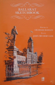
Book, Rigby Publishers Ltd, Ballarat Sketchbook, 1982
Hard covered book of 56 pages, with an orange dust jacket. The book includes information and sketches such as the Ballarat Town Hall, Lake Wendouree, Sovereign Hill, St Andrew's Kirk, St Patrick's Cathedral, Warrenheip, former Ballarat Gaol, Arch of Victory, Old Colonist' Hall, Ballarat Post Office. 2 Copies .1 & .2ballarat, architecture, building, drawings -
 Ballarat Tramway Museum
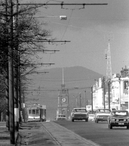
Photograph - Digital image, Peter Bruce, Sturt St into Drummond St North at 1.55pm, 1970s
Yields information about the Sturt St landscape looking east.Digital Image of a tram turning from Sturt St into Drummond St North at 1.55pm - long telephoto lens shot from about Ripon St, looking east. Mt Warrenheip in the far background. Photo taken by Peter Bruce 1970's and 1971 prior to the closure of the Ballarat System. Peter's Title of image: 1.55pmtrams, tramways, ballarat, sturt st, town hall, drummond st nth -
 Ballarat Tramway Museum
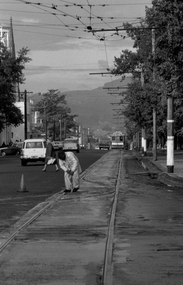
Photograph - Digital image, Peter Bruce, "Cleaning the Points", 1970s
Yields information about the Bridge St landscape looking east.Digital image of a SEC track cleaner at work at the intersection of Sturt and Drummond Streets. Has a tram disappearing into the distance along Sturt St, with Mount Warrenheip in the background. Not the tram poles and tram stops. Photo taken by Peter Bruce 1970's and 1971, prior to the closure of the Ballarat tramway system. Peter's Title of image: "Cleaning the Points"trams, tramways, sturt st, drummond st, track, track cleaner -
 Ballarat Tramway Museum
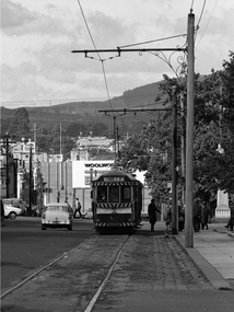
Photograph - Digital image, Peter Bruce, "No. 40 Lydiard and Sturt", 1970s
Yields information about the view down Sturt St looking towards Grenville St from Armstrong St.Digital image of No. 40 at the Lydiard and Sturt St intersection with passengers on the kerb line. Looking towards Grenville St with Woolworths store in the background and Mt Warrenheip from Armstrong St. Photo taken by Peter Bruce 1970's and 1971, prior to the closure of the Ballarat tramway system. Peter's Title of image: "No. 40 Lydiard and Sturt"trams, tramways, city, lydiard st, sturt st, tram 40 -
 Buninyong & District Historical Society
Photograph - Original Photograph, WWII "Spotting Shed" near Brim Brim, 1942, April 1942
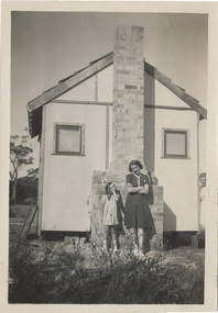
historic, warWWII "Spotting Shed" near Brim Brim, 1942. Built to observe aircraft. Later moved and used as bus shelter outside Masonic Temple.on rear; " Lorna & Mary taken up at the spotting post Attwood April 1942 "Herriot St. East up on hill. WW2, later shifted to cnr. Learmonth & Warrenheip St as bus shelter" Bob Skewes from Betty Murphy, Feb 1995spotting shed, wwii, masonic temple -
 Buninyong & District Historical Society
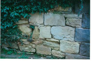
Photograph - Original Photograph, C J Brooks, Section of sandstone wall, 405 Learmonth St. Buninyong, July 1995
Stone of which wall is constructed is believed to have been used in the construction of Jamieson's Buninyong Inn, built for Margaret Jamieson starting about 1853. She owned the earlier Buninyong Inn which impinged on they surveyed Learmonth St. and was demolished. Margaret died in 1854 before the building was completed by her son, who built the third Buninyong Inn on the corner of Learmonth and Warrenheip. The two story hotel was tenented for a while, then bought by Dr. Sparling who demolished it.Colour photo, Section of sandstone wall, 405 Learmonth St. Buninyong.buninyong, jamieson, sparling, buninyong inn, wall, sandstone -
 Buninyong & District Historical Society
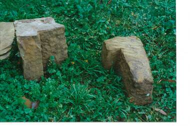
Photograph - Original Photograph, C J Brooks, Sandstone blocks awaiting incorporation into reconstruction of wall, 405 Learmonth St. Buninyong, July 1995
Stone of which wall is constructed is believed to have been used in the construction of Jamieson's Buninyong Inn, built for Margaret Jamieson starting about 1853. She owned the earlier Buninyong Inn which impinged on they surveyed Learmonth St. and was demolished. Margaret died in 1854 before the building was completed by her son, who built the third Buninyong Inn on the corner of Learmonth and Warrenheip. The two story hotel was tenented for a while, then bought by Dr. Sparling who demolished it.Colour photo, Sandstone blocks awaiting incorporation into reconstruction of wall, 405 Learmonth St. Buninyongbuninyong, jamieson, sparling, buninyong inn, wall, sandstone -
 Buninyong & District Historical Society
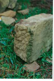
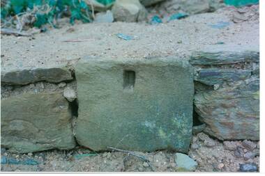
Photograph - Original Photograph, C J Brooks, Individual Sandstone block, awaiting incorporation into reconstruction of wall, for Mr. H & Mrs. D Westbrooke, 1995, at 405 Learmonth St. Buninyong, July 1995
Stone of which wall is constructed is believed to have been used in the construction of Jamieson's Buninyong Inn, built for Margaret Jamieson starting about 1853. She owned the earlier Buninyong Inn which impinged on they surveyed Learmonth St. and was demolished. Margaret died in 1854 before the building was completed by her son, who built the third Buninyong Inn on the corner of Learmonth and Warrenheip. The two story hotel was tenented for a while, then bought by Dr. Sparling who demolished it.Colour photo, Individual Sandstone block, awaiting incorporation into reconstruction of wall, for Mr. H & Mrs. D Westbrooke, 1995, at 405 Learmonth St. Buninyongbuninyong, jamieson, sparling, buninyong inn, wall, sandstone -
 Buninyong & District Historical Society
Photograph - Original Photograph, C J Brooks, Individual Sandstone block showing hole to support wooden strut, in reconstruction of wall, at 405 Learmonth St. Buninyong, July 1995
Stone of which wall is constructed is believed to have been used in the construction of Jamieson's Buninyong Inn, built for Margaret Jamieson starting about 1853. She owned the earlier Buninyong Inn which impinged on they surveyed Learmonth St. and was demolished. Margaret died in 1854 before the building was completed by her son, who built the third Buninyong Inn on the corner of Learmonth and Warrenheip. The two story hotel was tenented for a while, then bought by Dr. Sparling who demolished it.Colour photo, bottom section of wall, showing individual Sandstone block with hole to support wooden strut, in reconstruction of wall, at 405 Learmonth St. Buninyongbuninyong, jamieson, sparling, buninyong inn, wall, sandstone -
 Buninyong & District Historical Society
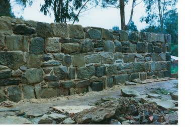
Photograph - Original Photograph, C J Brooks, Sandstone wall after rebuilding at 405 Learmonth St. Buninyong, July 1995
Stone of which wall is constructed is believed to have been used in the construction of Jamieson's Buninyong Inn, built for Margaret Jamieson starting about 1853. She owned the earlier Buninyong Inn which impinged on they surveyed Learmonth St. and was demolished. Margaret died in 1854 before the building was completed by her son, who built the third Buninyong Inn on the corner of Learmonth and Warrenheip. The two story hotel was tenented for a while, then bought by Dr. Sparling who demolished it.Colour photo, Sandstone wall after rebuilding at 405 Learmonth St. Buninyongbuninyong, jamieson, sparling, buninyong inn, wall, sandstone -
 City of Ballarat Libraries
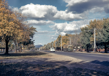
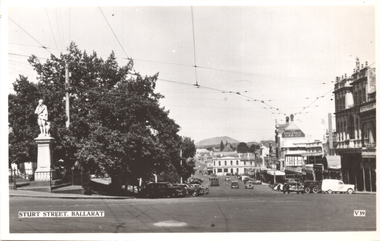
35mm Slide, Sturt Street West, Ballarat circa late 1950s
A lovely shot of the western end of Sturt Street, looking east to Mt Warrenheip. Not much traffic today! Just a tram and an early Holden, yet at the time of this photograph, this was the main highway through to Adelaide. Mrs Bon Strange and her husband Bert were well known Ballarat residents. When Mrs Strange died some years ago, her extensive slide collection was sorted through and those relevant to Ballarat were gifted to the Ballarat Library.sturt street, trams -
 Ballarat Tramway Museum
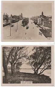
Memorabilia - Cigarette card - Ballarat, WD HO Wills, 1920s
Cigarette cards were used as a stiffening when cigarettes were sold as separate or loose items. See reference. Sturt St - Victorian Railways photo - mid 1920s with two ESCo trams in the view. Both trams have been fitted with windscreens. The rear of the card gives details of Ballarat and is No. 43 in a series of 100 card of the Australian Scenic Series. Lake Wendouree - looking east with Mt Warrenheip in the view. No. 26 of the series, also a VR photo.Demonstrates the type of card that were made by cigarette companies as collector items and to assist their sales.Set of two WD HO Wills Cigarette photo cards using a light card.ballarat, lake wendouree, sturt street, victorian railways, cigarette cards, wd ho wills -
 Federation University Historical Collection
Map, Ballarat Goldfield, c1898
This map shows geological features, suggests the last basalt flow, and includes alotments and names of Mining Companies. Although this map has no date on it the Ballarat Industrial School is used for dating purposed. The Ballarat Industrial School ran from 1869-1879, but the term Ballarat Industrial School Reserve was still in use in 1898 and possibly beyond.Geological Map of Ballarat with 3 holes in the left hand side. The map indicates the position of Lake Wendouree, Township of Warrenheip, Ballarat East, Industrial School Reserve, Winters Swamp, Police Paddock, Wyndholm Premptive Right (Salton and Waldie), Black Hill, Vale Park Reserve, Pennyweight Hill, Little Bendigo, Black Swamp Lead, monte Christo Reef, Chinaman's Gully, Miners Rest, Pincotts Dam, Northumberland Gully. It also show the following goldmining companies: City of Ballarat, Kohinor, Hand and Band, Great North West, Northern Junction, Kneeshaw, Rossers Freehold, Silurial.ballarat, warrenheip, lake wendouree, ballarat east, winters swamp, winter swamp, wyndholm premptive right, cemetery, vale park reserve, little bendigo, kneeshaw co., industrial school reserve, kirks dam, pincotts dam, black hill, wombat hill, dead horse gully, miners rest, mt rowan, salton and waldie, rose hill co, great north west no 1, rose's freehold co, hand and band co, police reserve, police paddock, mount rowan, ballarat industrial school reserve, market reserve, winter's swamp, kneeshar co, monte cristo line of reef, chinaman's gully or black snake, milkmaid's gully, ballarat gold field, bakery hil lead, old gravel pits lead, golden point lead, eureka lead, miner's rest, yarrowee creek, leigh creek, black swamp lead, yorkshire reef, nil desperandum reef, cockatoo lead, hit or miss gully, herbert werner frederick de nully, pennyweight hill, esmond's lead, ash's lead, nightingale lead, john bull gully, gladstone reef, whitehorse reef, petticoat creek, pincott's dam, frenchman's gully, tim's crushing plant, jenkin's gully, california gully, drake's creek, sulton and waldie, ballarat undustrial school, ballarat & mariborough railway -
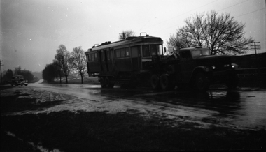 Ballarat Tramway Museum
Negative, Wal Jack, early 1950's
Yields information about the method of delivery of bogie trams from Melbourne and the Western Highway near Ballarat early 1950'sNegative and Digital images of the Wal Jack Ballarat Negative file of the delivery of a bogie tramcar on a very wet day using a Yellow Express truck. Would appear that the railway line is on there right hand side, possibly just before the Caledonia bridge under the railway line at the foot of the Warrenheip bank on the Western Highway. Timing related to Reg Item 5327i, btm5207i, delivery of ex MMTB 42 or 35.trams, tramways, delivery of tramcars, railways, bogie trams, ballarat -
 Ballarat Tramway Museum
Photograph - Digital image, Peter Bruce, "No. 41 Loading for Sebas", 1970s
Yields information about the stop in the City on the south side of Sturt St and loading passengers.Digital image, black and white, of No. 41 loading passengers for Sebastopol at the city terminus. A number of passengers, including one carrying an umbrella are boarding. Shows the signage at the city stop. In the background is Bridge St, looking along to Victoria St and Mt Warrenheip. Another tram is in Bridge St. Photo taken by Peter Bruce 1970's and 1971, prior to the closure of the Ballarat tramway system. Peter's Title of image: "No. 41 Loading for Sebas"trams, tramways, city, sturt st, bridge st, sebastopol, tram 41 -
 Federation University Historical Collection
Postcard - Images, Views of Ballarat, c1920
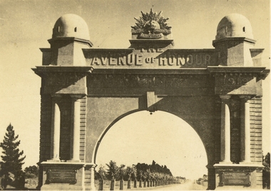
Six small black and white postcards depicting views of Ballarat. .1) Sturt Street Gardens Ballarat, c1920 .2) Gong Gong Reservoir, Ballarat, c1920 .3) Sturt Street, Ballarat, c1920 .4) Sturt Street, Ballarat, c1920 .5) Sturt Street Looking Towards Mount Warrenheip, Ballarat, c1920 .6) Ballarat Arch of Victory, Ballarat, c1920. This view shows newly planted trees in the Ballarat Avenue of Hunour. ballarat, sturt street, sturt street gardens, mt warrenheip, trams, gong gong reservoir, ballarat arch of victory, gallaway memorial, galloway fountain, ballarat avenue of honour, harry davies, arch of victory, harry davies and co, ballaarat mechanics' institute, st andrew's kirk -
 Buninyong & District Historical Society
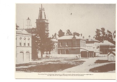
Print - Sepia print for calendar, Town Hall precinct, 1890's, Town Hall Precinct, Learmonth St. 1890's
buildingsPrint of Town Hall Precinct, Learmonth St. 1890's. Printed for calendar, mis-lInscription "Warrenheip Street, Buninyong. Taken prior to 1930, showing the Buninyong Hotel and the weighbridge, to the right, and the fire brigade building on the left, all now demolished." Inscription is inaccurate, it is Learmonth St. the brick building centre is Whyke's Butchers, built 1893, and the fire station burnt down in 1989, dating photo more accurately to 1890's.learmonth st., town hall precinct, fire station (first), whykes butchers, buninyong hotel, weighbridge, national bank -
 Ballan Shire Historical Society
Map - Map. Kerrit Bareet, Department of Lands and Survey, Kerrit Bareet. County of Grant, 08/1944
A map of the Kerrit Bareet area within the County of Grant showing properties and names of owners in 1944.Significant to people researching land usage and ownership. Also those researching families in the area at that time.A map of Kerrit Bareet in the County of Grant. Black printing on buff coloured paper. Details roads, rivers, railways, property boundaries and names of property owners and towns and villages. The map is easily readable although there is some physical damage and that and the borders have been reinforced with sellotape. Shows a Scale in Chains and Price 2/.gordon, bungal, kerrit bareet, lal lal, moorarbool river, warrenheip, bungaree, wallace, moorarbool west -
 Ballarat Tramway Museum
Postcard, Valentine & Sons Publishing Co, "Sturt Street, Ballarat", c1950
The photo shows the view of the south side of Sturt Street from Lydiad St, looking east. The Robbie Burns statue is on the left of the card, along with the Mechanics Institute, The Ballarat Gas Co, Buckshead Hotel. There is one tram parked in the parking loop. On the rear, Wal Jack in a note to Ken Magor has written: "4 wheeler (No. 30 or 33?) in parking loop. Lower Sturt St from Lydiard St, looking east showing narrow Bridge St and Victoria St hill. Mt Warrenheip 4 miles away." Has a sketch of the tram tracks as well. C1950Yields information about Ballarat during the late 1940s or early 1950s.Postcard black and white, undivided back, with a handwritten note on rear. Card No. V39.See image 2 for details of the handwritten note by Wal Jack on the rear. tramways, trams, sturt st, valentine -
 Ballarat Tramway Museum
Photograph - Digital image, Keith Kings, 7/04/1962 12:00:00 AM
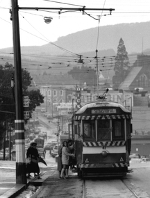
Yields information about the arrangements made to transport ARHS members on a tram tour of Ballarat in 1962.Digital image from the Wal Jack Ballarat Album of a photograph of the ARHS Specials outside the tram depot on tour on 7/4/1962. Keith Kings Photograph N(e)(11). Tram Nos. (from rear) 41, 28, 36, 14, 37, 33, 35, 31, 38. Printed on Ilford paper. See image i2 for rear of photographOn rear of photograph in ink "Ballarat, ARHS specials shunting into Depot for lunch layover. Nos. 41, 28, 36, 14, 37, 33, 35, 31, 38. No. 20 is behind camera with "photo party" for Warrenheip. Sat. 7/4/62" and has Keith Kings stamp and number N(e)(11) in bottom right hand corner.trams, tramways, arhs, special trams, wendouree parade, tram 38 -
 Ballarat Tramway Museum
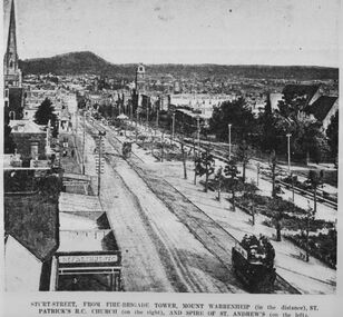
Photograph - Digital image, c1890's
Yields information about the appearance of Sturt St Ballarat c1971.Digital image copy of a black and white print of Sturt St from the Fire Brigade tower looking east. Has title "Sturt St from fire Brigade Tower, Mount Warrenheip (in the distance), St. Patricks RC Church (on the right), and Spire of St Andrew's (on the left). Has a well loaded horse tram outbound on the north side of Sturt St. C1890's, trees in the median strip are still young. On rear is "BTPS Sales department" in green ink. trams, tramways, sturt st, horse trams -
 City of Ballarat Libraries
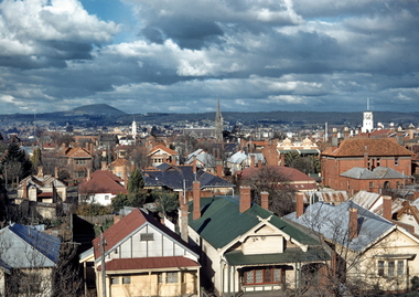
Slide, View east over houses from Ballarat Hospital circa late 1950s
This image appears to have been taken from Ballarat Base Hospital, looking east over Drummond Street to Mt Warrenheip. The City Fire Brigade tower painted white can be seen to the right, while St Andrew's Kirk dominates the middle ground of the photograph. Many photographs over the years have been taken from this viewpoint, and are interesting to compare. Mrs Bon Strange and her husband Bert were well known Ballarat residents. When Mrs Strange died some years ago, her extensive slide collection was sorted through and those relevant to Ballarat were gifted to the Ballarat Library.mount warrenheip, ballarat east -
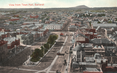 Ballarat Tramway Museum
Postcard, Valentine & Sons Publishing Co, "View from Town Hall, Ballarat", c1908
Valentine Series postcard of Postcard, looking towards the East, Grenville St, and Mount Warrenheip. Shows two trams westbound and has the 1907-built tramway shelter in the view. Shows Alfred Hall, exhibition buildings, and very good details of buildings in Grenville St. Title of the card in red ink "View from Town Hall, Ballarat" in the top left-hand corner. It is the divided back type, with words "Post Card", and a location for the stamp. It is "Printed in Great Britain" and published by "The Valentine & Sons, Publishing Co. Ltd. Melbourne" on the right-hand side. See item 4082 for the same image but with a decorative border. Yields information about Sturt St and the view from the Town Hall tower, c1908Postcard black and white, divided back, unused.Has the stamp of Ken Magor on the rear. tramways, trams, sturt st, postcards, grenville st, town hall -
 Ballarat Tramway Museum
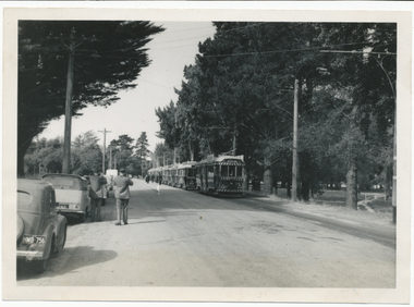
Photograph - Colour Print/s - set of 4, Earl Ewers, 28/05/2011 12:00:00 AM
Yields information about the BTM's 40th anniversary celebrations, and some of the people involved.Set of four colour prints of trams in Wendouree Parade during the 40th anniversary celebrations. Taken by Earl Ewers, printed on Fujichrome paper. Taken 28/5/2011 .1 - No. 27 as service tram, entering Gardens Loop. .2 - No. 33 at the Crossing Loop, with Sovereign Caravans and Eureka Roofing Tiles roof adverts. .3 - ditto at Carlton St. .4 - ditto at St Aidans DriveOn rear in blue pen .1 - No. 27 as service car, Wendouree Parade Ballarat 28 May 2011 .2 - No. 33 on a "special", Wendouree Parade Ballarat 28 May 2011 .3 - No. 33 at Carlton St terminus, Ballarat Gardens 28 May 2011 .4 - No. 33 Lake Wendouree, Mt Warrenheip, Black Swans, Ballarat Gardens 28 May 2011.trams, tramways, 40th anniversary, lake wendouree, wendouree parade, gardens loop, tram 27, tram 33 -
 Federation University Historical Collection
Document, Keith E. Rash, Ballarat Gold Discovery, c1970
Three handwritten pages relating to gold discovery at Ballarat.ballarat, gold discovery, smythesdale, bunninyong, warrenheip, geology, archibald yuille, pyrenees, clunes, herbert swindles -
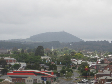 Victorian Interpretive Projects Inc.
Photograph - Photograph - Colour, Clare Gervasoni, Ballarat from the top of the Ballarat State Offices, 2013, 22/11/2013
A number of photographs of Ballarat taken from the top of Ballarat's former State Offices, Camp Street.ballarat, ballarat state offices, ballarat trades hall, mt buninyong, mt warrenheip, bunninyong, warrenheip, ballarat post office, black hill, state offices -
 Federation University Historical Collection
Map, Municipality of Ballarat East, 1857
Gold was discovered in Ballarat in 1851. This plan was created six years later and names some of the great gold locations of Ballarat East. It also shows the locality of the Eureka Stockade (1854) and the walking tracks and roads on the Ballarat East Goldfield.In 2007 this map was listed on the inaugural Ballarat Treasure's Register.Large map backed onto linen. The map has read and blue highlights, and identifies areas such as Mount Pleasant, Golden Point, White Flat, Nightingale, Malekoff, Old Post Office Hill, Red streak, Gumtree Flat, Old Gravelpits, Bakery Hill, Ballaarat Flat, The Camp, Specimen Gully, Pennyweight Hill, Warrenheip Gully, Gays Gully, Pennyweight Flat, Eureka, Black Hill, Pinchgut, Crocodile, Hit or Miss, Little Bendigo, Brown Hill, Mopoke, Cricket Reserve, Canadian Hotel, Ballarat Eastmount pleasant, golden point, white flat, nightingale, malekoff, old post office hill, red streak, gumtree flat, old gravelpits, bakery hill, ballaarat flat, the camp, specimen gully, pennyweight hill, warrenheip gully, gays gully, pennyweight flat, eureka, black hill, pinchgut, crocodile, hit or miss, little bendigo, brown hill, mopoke, cricket reserve, canadian hotel, ballarat eastm phillips, john phillips, field draughtsman, ballarat east, ballarat east map -
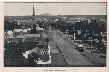 Ballarat Tramway Museum
Photograph - Illustration, "Sturt Street Ballarat to-day", c1905/6
Set of two views from an illustrated publication on Ballarat. 1 - Illustration - "Sturt Street Ballarat to-day" looking east from the City Fire station along Sturt St with an ESCo tram eastbound. The destination sign is mounted on the dash panel indicating c1905/1906. In the view are Ballarat's Buildings, Mount Warrenheip, J Taylor Redhouse Bakery, and on the bottom edge a sign for Marshall's. 2 - Illustration - Post Office Ballarat, to-day - with an ESCo tram turning from Sturt St into Lydiard St North, with the Post Office in the view along with many pedestrians and some horse drawn vehicles. See also item 6245 for a postcard of the same view.Yields information about Ballarat and city views in 1905/1906.Illustration cut from a magazine or publication - set of two - back to backThe second image has "1912" in pencil along the bottom edge.ballarat, illustrations, sturt st, esco, post office, lydiard st nth -
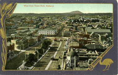 Ballarat Tramway Museum
Postcard, Valentine & Sons Publishing Co, Sturt St taken from the Town Hall tower, looking towards the East, c1908
Postcard - , looking towards the East, Grenville St and Mount Warrenheip. Shows two trams westbound and has the 1907-built tramway shelter in the view. Shows Alfred Hall, exhibition buildings, and very good details of buildings in Grenville St. Title of the card in red ink "View from Town Hall, Ballarat" in the top left-hand corner. On the rear of the card, has the stamp of Ken Magor. It is the divided back type, with words "Post Card", and a location for the stamp. It is "Printed in Great Britain" and published by "The Valentine & Sons, Publishing Co. Ltd. Melbourne" on the right-hand side. See item 8985 for the same image but without a decorative border.Yields information about Sturt St Ballarat and demonstrates Australian colour photo postcards with a decorative border.Colour postcard of Sturt St taken from the Town Hall towerHas in pencil $6.50 along top edge on rear.trams, tramways, postcards, sturt st, ballarat, grenville st, town hall -
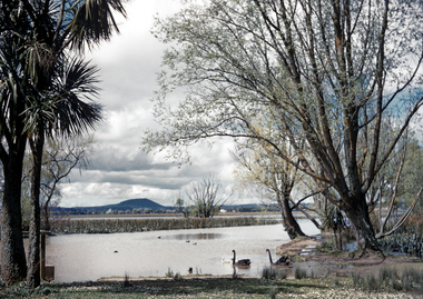 City of Ballarat Libraries
35mm Slide, Lake Wendouree circa 1950s
A view from the "Fairyland" area of the Wendouree Lake showing Mount Warrenheip in the background. Lake Wendouree is often considered the soul of Ballarat according to advertisements from the early 1900's saying "Sydney may have it's Harbour, Melbourne, it's bay but Ballarat has Lake Wendouree." This may have been Mrs.Strange's favorite spot to photograph the Lake, another image in this series captures the same area in a different mood. Mrs Bon Strange and her husband Bert were well known Ballarat residents. When Mrs Strange died some years ago, her extensive slide collection was sorted through and those relevant to Ballarat were gifted to the Ballarat Library.lake wendouree