Showing 307 items matching "water scheme"
-
 Kiewa Valley Historical Society
Timer Favag, Circa 1950
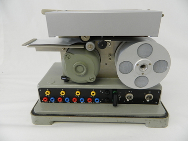
This Favag Timer apparatus was a part of the first electronic control system -(1960's), in Victoria), which worked using telephone stepping selectors to convey a change in voltage providing a regulated pulse from the control centre(Mount Beauty) to the remote Power Stations opening and closing (stop/start) of various devices at the Power Station and a return signal confirmed the action taken. Testing of this unit was carried out using a "dummy" device at the remote Power Station so as not to disrupt the power plant's operation. This timer was one of many electrical apparatus connected to the large SEC Victoria Hydro Scheme's electrical power producing generators. These generators are powered by the hydro force of "stored" water at a higher altitude. The establishment of both the NSW and Victorian Hydro Schemes was achieved from the early 1900's to the 1960's. At this point in time the need for additional power sources to quench both an industrial and domestic demand for electricity was purely an economic and not and environmental (carbon reduction) factor. This hydro scheme was instigated by "the Government of the day" as a bold move and was the major force of the World War II refugee and "technical" workforce,inclusion of skilled and unskilled, migration into the Australian environment. Although this mass "invasion" of workers with families was thought of in some circles as intrusive, the expansion of population post war years and its integration into the Australian rural sector, produced the multi- lingual multi-cultural diversity of later years.This Favag Timer was one of the crucial pieces of equipment that made it possible for the Mount Beauty Terminal Station to control the operations of these Power Stations; McKay, Clover, West Kiewa Power Stations and the Dederang Terminal Station.This aluminium and anodised "FAVAG" (pulse) timer is fastened to a base structure which comes with its own metal cover that is fastened by two metal hooks. From the top of these hooks runs a thick leather "carry" strap.The instrument, itself, a small "micro motor" at one end tape feeding spool on the other. Aluminium metal structures offer a preventative barrier against any electronic spikes from static electricity sources. There are two toggle switches to the bottom right hand side and twelve coloured "pin" connection points.There is a sliding access sleeve which exposes a circuit board.with various leads fastened on each side. In front of one of this slide are two "screw in" fuses, spare fuses are in a small envelope taped above. Circuit diagrams are etched white on black background on the top face of the main structure. At the base of the back section is a two pronged input terminal. There is a fine black rubber layer (cushioning) for the mian top cover.On the cover fastened with two rivets "FAVAG" underneath in small print "Fabrique d'appareils electriques S.A." underneathe "NEUCHATEL-SUISSE". on one end is a "STATE ELECTRICITY COMMISSION OF VICTORIA" metal label screwed on.The back label has manufacturers' type and model number.sec vic kiewa hydro scheme, alternate energy supplies, alpine population growth -
 Kiewa Valley Historical Society
Drill Bit Diamond, circa mid to late 1900's
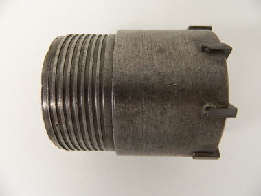
This hollow core bit has hard cutting inserts for drilling into rock. It was used to drill and recover 50mm diameter (most common size) rock cores. The rock cores were assessed by geologists and engineers to provide information for design of structures such as tunnels, dams and underground power stations (eg. McKay Creek Power Station, West Kiewa Power Station). This type of bit was also used where damage to the surrounding rock had to be minimised. The Diamond Drill Bit,used in the early 1900's, when it was primarily used as a method of sampling rock for ore deposits and oil exploration resulting in a "coring" of rock. The use of "coring" to obtained samples for the SEC Kiewa Hydro Electricity Scheme(1920's onward) was to analyse the core to obtain temperature and rainfall patterns shown by the levels of layered solidified soil(rock). This diamond drill would have been used in the early 1900's to provide a sub strata map of temperature and water patterns (over an long period of time). This was a pre requisite to any decisions about the viability of the region to provide the water needed for a successful hydro electricity scheme.This diamond drill for core sampling was at the forefront of the analysis whether to construct a hydro electrical facility in the Kiewa Valley and the adjoining alpine region. The rock core samples produced were assessed by geologists and structural engineers. It was only after extensive core drilling covering the region that solid scientific evidence could be provided to start the "SEC Vic Hydro Electricity Scheme" within its current boundaries.This "diamond" drill bit has eight "teeth" at its cutting edge. The drill creates an 55mm hole in extremely hard rock material to obtain 50mm core samples.. Three quarters down the shank it has thread screw channels to attach the bit to the drill pipe. The coring pipe attaches via screwing it onto this bit. Core samples are the main objective of this tool.alternate energy supplies, alpine feasibility studies temperature, rainfall, sec, kiewa hydro electric scheme, electricity -
 Kiewa Valley Historical Society
Tester Direct Current, mid 1900's
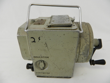
This tester was used between 1950 and 1980's. As part of the Occupation, Health and Safety requirements, equipment used to monitor the performance of electricity producing generators, regularly, hand held testers were used to check the insulation and the "earth" pin were up the the required operational levels. As the generators and their ancillary monitoring equipment was spread over a large area and cumbersome to service small hand held devices were required. These had to always be safe for the user to operate. A selected range of high quality meters were recalibrated every two years in the Meter and Calibration Laboratory at Yarraville(near Melbourne) This meter is very significant to The Kiewa Hydro Electricity Scheme because it was an integral part of maintaining the electricity producing water driven generators of the power stations. The reason why this meter was so essential is that provided the safety check on equipment used to monitor each Hydro Generator that they were complying within the grid network parameters. Grid parameters are set so that if there is an electrical fault on the system, that fault can be attended to with a very small change in the output stability of each generator. It is essential that the voltage of the network remain within the set limits. Generators are at Dartmouth, Mackay, Clover, West Kiewa, Yarrawonga, Cain Curran and three Power Stations in the Thornton area.This hand driven current generator produces 500 volts by winding the handle(on funnel curved side) to keep the voltage constant(one minute per test). The whole body is made from caste aluminium. One of the functions of this meter is to test the isolation resistance of any equipment being tested. This is to see if that equipment is safe to handle(no electrical shocks). The second function is to test the earth pin of any portable electrical equipment. The turn key on one side can direct which function is required(marked insulation or continuity). On the top side(enclosed in a glass fronted marked scale) is a continuity scale(top) and an insulation scale(bottom). This is covered , when not in use by "flip up" lid with manufacturer's details and name of the instrument. Opposite the winder are two screw tight knobs. One marked earth(left side) and one marked line(right side). On the top and next to the glass windowed scales in a post manufacture SEC Vic equipment equipment ID number. For carrying purposes there is chromed steel (fold together) handle.The bottom of the unit has two metal "feet" 150mm long by 114mm wideManufacturer's details on top side "MEG" underneath "INSULATION AND CONTINUITY TESTER" below this "constant 500 VOLT pressure" below this "REGISTERED MEG MEGGER TRADE MARK" below this "REG DESIGN NO. 690326" below this "UNITED KINGDOM PATENT Nos. 193746, 197178, 198182, 202062, 202398, 204649, 350715" below this "SUPPLIED BY THE GENERAL ELECTRIC Co. Ltd OF ENGLAND" below this "MAGNET HOUSE, KINGSWAY LONDON W.C.2" 'sec vic kiewa hydro scheme, alternate energy supplies, alpine feasibility studies temperature, rainfall -
 Kiewa Valley Historical Society
Case leather
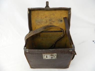
This case was used between 1950 and 1980's. As part of the Occupation, Health and Safety requirements, equipment used to monitor the performance of electricity producing generators, regularly, hand held testers were used to check the insulation and the "earth" pin were up the the required operational levels. As the generators and their ancillary monitoring equipment was spread over a large area and cumbersome to service small hand held devices were required. These had to always be safe for the user to operate. A selected range of high quality meters were recalibrated every two years in the Meter and Calibration Laboratory at Yarraville(near Melbourne)This leather case contains a meter which is very significant to The Kiewa Hydro Electricity Scheme because it was an integral part of maintaining the electricity producing water driven generators of the power stations. The reason why this meter was so essential is that provided the safety check on equipment used to monitor each Hydro Generator that they were complying within the grid network parameters. Grid parameters are set so that if there is an electrical fault on the system, that fault can be attended to with a very small change in the output stability of each generator. It is essential that the voltage of the network remain within the set limits. Generators are at Dartmouth, Mackay, Clover, West Kiewa, Yarrawonga, Cain Curran and three Power Stations in the Thornton area.This carry case is made from leather hide and cloth covered cardboard insert. The front side has a lockable English made suitcase fitting. It has a broken carry strap (leather) travelling from top and through leather strap holders both sides and on the bottom of the case. A State Electricity Commission of Victoria identification tag riveted onto the top lid "ELECTRICAL ENGINEERING SECTION No. 1483"sec vic kiewa hydro scheme, alternate energy supplies, alpine located electricity generators, mobile measuring equipment -
 Eltham District Historical Society Inc
Photograph, George W. Bell, Christmas Hills bushfire, Jan. 1962, Jan 1962
Building of Pensioners Cottages at St Andrews; for those burnt out in the 1962 bushfires. A voluntary scheme of Mavis Gill through the Kangaroo Ground Relief CommitteeBlack and white photo mounted on cardChristmas Hills bushfire Photo Geo. W. Bell, Jan. 1962victorian bushfires - 1962, bushfires, fire damage - buildings, george w bell, houses, st andrews, mavis gill, pensioners cottages, christmas hills, water tank -
 Kiewa Valley Historical Society
Ron White's Collection - 1920 - 2019
Ron White was born in 1920. He received a Diploma of Mechanical Engineering at Footscray Technical School in 1946. He started work as a laboratory assistant and after several promotions was appointed Senior Operator in 1948. In 1949, he was Engineer, Grade 1 (Hydro Areas). After further promotions he became Assistant Area Engineer, Rubicon at new Eildon Power Station and Area Engineer, Kiewa in commissioning Mt Beauty Terminal Station and West Kiewa Power Station.. By 1956, he was the Area Operations Engineer at Kiewa and four years later the Kiewa Electrical Superintendent (Operations and Maintenance) . In 1961, he was officially recognised as deputy for the General Superintendent, Kiewa. In 1966 he was appointed General Superintendent Kiewa and Kiewa became 'a branch of the Transmission Department'. In 1974, the Rubicon / Eildon Area was also under Ron's control. His title was "Principal Hydro Engineer, Hydro Division, Transmission Operations Department. He held this position until his retirement in 1985.Ron White was an important identity in his role as Principal Hydro Engineer from 1966 to 1985 after the completion of the Kiewa Hydro Electric Scheme. His long period of service involved him in the construction, operation and maintenance of the SECV's Hydro Electric Schemes and administration of related catchment areas. He had a close association with the local communities and care for the welfare of employees. He lived in Mt Beauty and was well respected in the community and beyond. He passed away on 30 September 2019, aged 99 years.A) History of Ron White's Working Life: including papers relating to "Promotion & Staff Appointment" B) Ron White's Retirement - 11th Jan. 1985: papers, cards, letters, photos, disc/plaque C) Ron White's Certificates: Diploma of Mechanical Engineering; First Aid; D) Ron White's Correspondence - miscellaneous E) Ron White's History of the 'Kiewa Scheme' from 1936- 1966. Written 1986 F) Ron White's Photo album Includes photos of him and the 2003 bushfires G) Miscellaneous Photos (not labelled) from Ron's photo album. Possibly relatives including nieces and nephews. H) Pewter Mug presented to Ron - Water Board I) Wall hanging presented to Ron - Scouts J) Ron White's Slide Ruler & Mathematical Instruments K) Collection of 7 books owned by Ron L) Starting Pistol Caps box M) Ice-cream serverF) One photo of Ron with 'Ken Connors'. One photo with 'l to r: Norm Middleton, Graham Napier, Ron White, Les Peart.' G) 2003 fires has a note re time, date and whereabouts of fires H) "Presented To / Ron White / In Appreciation For Service / To The / Kiewa Valley / Water Authority / And / Its predecessor Bodies / December 1994 I) Wall hanging: On emblem - "Lord Baden-Powell Society / The Scout Association of Australia". On Name Plate below - Ronald K. White 1989" J) mathematical Instruments have 'R. W' embossed in red on the corner of the cover M) 100 Straitline, Starting Pistol Caps N) National Ice-cream Server with stainless steel spring Size 20 ron white, hydro engineer, kiewa hydro electric scheme -
 Kiewa Valley Historical Society
Kiewa Hydro Electric Scheme - Extract from 'Water Power' June 1962 & 'Kiewa Keynotes' from SEC Magazine
... Kiewa Hydro Electric Scheme - Extract from 'Water Power... electric scheme secv magazine kiewa keynotes water power ...The SECV produced a magazine from the 1930s describing each of their locations where their employees were working. Bogong and Mt Beauty were the towns where the workers on the Kiewa Hydro Electric Scheme lived as well as in camps on the Bogong High Plains. The magazines kept everyone up to date on the SEC work and social activities at all locations creating a Work Community for all employees as they moved from one job to another.Photocopied pages 213 to 221 from the book 'Water Power' June 1962 and photocopied pages from SEC Magazine - Kiewa Keynotes circa late 1940s-early 1950skiewa hydro electric scheme, secv magazine, kiewa keynotes, water power -
 Kiewa Valley Historical Society
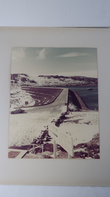
Photo - Rocky Valley Dam
The State Electricity Commission of Victoria constructed the Kiewa Hydro Electric Scheme on the Bogong High Plains. The scheme consisted of storage dams and pondages, aqueducts, tunnels, pipelines, transmission lines and three power stations.. Rocky Valley dam was the biggest storage and the last to be completed.Rocky Valley dam was the largest storage within the Kiewa Hydro Electric Scheme. Begun in 1954 and completed in 1960. It was linked to McKay Creek Power StationColoured photo attached to cream cardboard. The background shows hills and the foreground a sign "Rocky Valley Dam ..." The middle shows the dam with water and its bank. There is snow on the ground.rocky valley dam, kiewa hydro electric scheme, secv -
 Kiewa Valley Historical Society
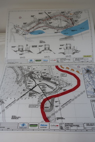
Plans - Southern Hydro - Bogong Power Development
Southern Hydro owned the Kiewa Hydro Electric Scheme in May 2006 when these plans were created. The Site No. 1 and Site No. 2 are part of the Bogong Power Development Bogong Power Development is part of the Kiewa Hydro Electric SchemeLaminated A3 plans mostly black and white but with a little color and surrounded by a grid.(Also see KVHS 1439) 1. Tunnel and Civil works / Commissioners Lodge Site Plan 1: Site No. 1 / TBN /Water /Supply / Reservoir Site 2. Tunnel and Civil Works / Pedestrian Diversion Access Paths / and Tracks: Site No. 2 / Lake Guy Site / Bogong Victoriabogong power development, southern hydro 2006 -
 Kiewa Valley Historical Society
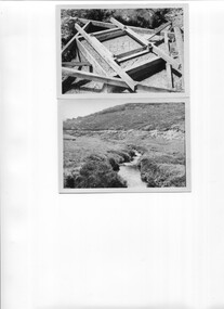
Photos - x6 Raceline repairs on the High Plains
... Hydro Electric Scheme Raceline Water Power Bogong High Plains ...As part of the Kiewa Hydro Scheme the race lines were created to catch the water and direct it into the Rocky Valley Storage Dam.Part of the Kiewa Hydro Electric Scheme on the Bogong High Plains.6 black and white photos:- 2 with concrete framework, 2 concrete completed and 2 High Plaines race line.Alec McCullough Collectionkiewa hydro electric scheme, raceline, water power, bogong high plains -
 Kiewa Valley Historical Society
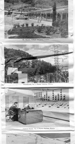
Postcard - Mt Beauty and the Kiewa Hydro Electric Scheme
SECV constructed the Kiewa Hydro Electric Scheme including the township of Mt Beauty. The area became a popular tourist destination.Tourism in the Kiewa Valley especially at Mt Beauty and the Bogong High Plains along with the Kiewa Hydro Electric Scheme became very popular and an important industry.Fold out b & w postcard with 12 photos back to back. All with a title. Kate 1950s 1. High Voltage Transmission Line, showing Mount Beauty Township 2. Clover Dam Reservoir, Kiewa 3. No. 3 Power Station, Kiewa 4. Generators, No. 3 Power Station 5. Turbines, No. 4 Power Station, Kiewa 6. junction Dam, Bogong 7. Mt Beauty Village Shopping Centre 8. Switchyard, No. 4 Power Station, Kiewa 9. Control Room, No. 4 Power Station, Kiewa 10. Winter Scene at Rocky Valley on the Bogong High Plains 11. Water Channel, Mt Bogong in Background 12. Mt Beauty Township, Kiewa Valleytransmission line, power station, generators, mt beauty, turbines, junction dam, switchyard, rocky valley, control room -
 Kiewa Valley Historical Society
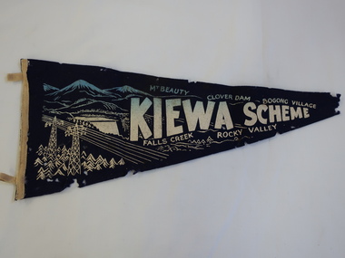
Pennant - Kiewa Scheme
Pennants are used to advertise events or places. This pennant includes all the main areas of construction done by the State Electricity Commission of Victoria during their construction of the Kiewa Hydro Electric Scheme. The pennant advertises the highlights in the construction of the Kiewa Hydro Electric Scheme.A small triangular navy blue with gold printing fabric with a strip of woollen bias binding on the left side with a tab at the top and bottom for attaching to a rod to enable the pennant to hang. The background of the printing is of mountains with water flowing out of a dam and in the front on the left power poles and power lines.In gold - large letters"Kiewa Scheme" decreasing in size. On the top also in gold "Mt Beauty" "Clover Dam" and "Bogong Village" and underneath "Falls Creek" Rocky Valley"kiewa scheme, pennant -
 Kiewa Valley Historical Society
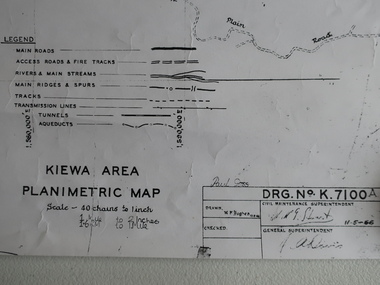
Map - Kiewa Area Planimetric Map
Planimetric maps are two-dimensional representations of the Earth's surface, showing the location and spatial arrangement of features such as roads, buildings, and bodies of water.A very clear map showing the Kiewa Hydro Electric Scheme in two dimensions to include the construction done by the SECV.Black and white Map of the Kiewa Area from Mt Beauty to the High Plains covering the Kiewa Hydro Electric Scheme and surrounds. Drawn on 11th May 1966kiewa hydro electric scheme 1966 -
 Kiewa Valley Historical Society
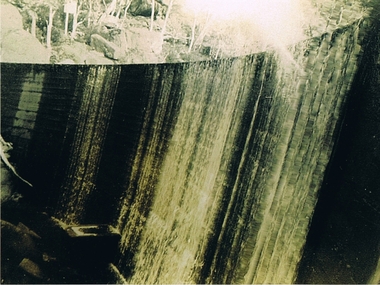
Photograph Clover Dam, Clover Dam Circa 1940, circa 1940s to 1950s
As part of the push to cut electricity costs and diversify supply, the Victorian Government (circa 1930) implemented the conversion strategy from mainly brown coal supply to hydro - electricity. The Kiewa Hydroelectric Scheme became the largest scheme of its kind in the State Of Victoria and the second largest scheme in Australia. This dam was constructed to supply water to feed four turbines (62 mega watts) at the West Kiewa Power Station. This was at the forefront of sustainable "Green" energy. Costs associated with power supplies is still a major incentive of governments, however environmentally friendly alternatives such as wind and nuclear have also made inroads. The Kiewa valley and its surrounding alpine catchment were looked at(Victorian State Government), from the beginning of the twentieth century as a source of alternate power for an every increasing demand for electricity by growing population and heavy industrial ares within Melbourne City and State regions. Construction of dams, such as Clover Dam provided the large quantity holding areas of water required to turn the turbines at the various power stations to provide the electricity needed. The impact of these controls by moderating water run off from the alpine regions is beneficial in reducing flooding from thawing of snow on the alps. This by-product allows agriculture and grazing to be less vulnerable to seasonal flooding thereby resulting in a more stable annual production level.Reproduction (scanned) of a black and white photo of Clover Dam circa 1940. The paper used is KodakXtraLife II paperThe reverse side of photo " KodakXtraLife II paperdams, pondage, hydro electricity, power stations, clover dam, secv -
 Kiewa Valley Historical Society
Photograph of Lake Guy and Bogong Village, Lake Guy and Bogong Village, Approx. 1945
In 1940 Field Headquarters for the Kiewa Scheme were established at Bogong with office, workshop facilities and accommodation for workmen, staff and some families constructed. (There had been a 'tent camp' on this site in 1939 but was destroyed by bushfires) Construction of accommodation continued until 1947. A total of 40 houses plus a hostel for single staff, post office, police station, medical centre and primary school all with water and sewerage and electricity supply. The staff hostel was known as Kiewa House and is now occupied by the Education Department. Lake Guy was named after Mr. L.T. Guy who was the Resident Engineer in charge of construction work and associated activities on the Kiewa area. He held this position from 1939 to November 1946 when he was transferred to Head Office.This photograph is an excellent historical record of Bogong Village in about 1945. It shows the layout of the town in the fairly steep terrain, the workmen's camp between the houses and the lake foreshore, the Commissioner's Lodge on the hill behind the Village, the walkway through the dam wall can be seen to the left of the spillway, the dam is on spill and note damage to the large trees is still evident from the 1939 bush fires. The Commissioner's Lodge was lost in the 2003 fires and the camp buildings were in service until 1962, when they were removed and the site converted into a public picnic area with lawns and gardens.A Black and white photograph"Lake Guy and Bogong" hand written on back of photograph.kiewa, accommodation, lake, dam, bogong -
 Kiewa Valley Historical Society
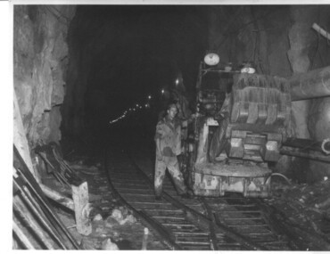
Photograph of Rail Mounted Battery operated soil Bucket, between 1941 and 1946
This machine was in use in the 1940's during the construction of the tunnels for the Hydro Electric scheme. This particular photograph was taken in the Tailrace Tunnel which brings water from West Kiewa Power Station to the open tailrace in Mt. Beauty and then into the regulating pondage before discharge into the Kiewa River. This machine (or one similar) is on display on the Northern side of the entrance to the Visitor's Centre. The tailrace tunnel (or West Kiewa tunnel) was commenced in 1947 from both ends and the breakthrough occurred on 22nd. July, 1950Shows the size of the tunnel and the machinery used for excavation in the 1940's/50's.Black and white photographHandwritten on back of photograph "Jumbo" in Tailrace Tunneltunnel, machinery, water, tail race -
 Kiewa Valley Historical Society
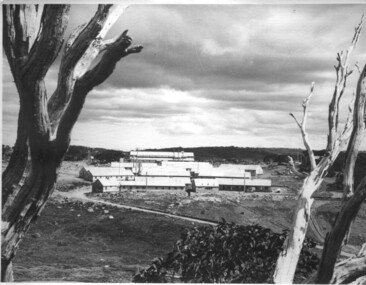
Photograph of Howmans Dam Camp, Howmans Dam Camp, circa 1948
... water for No. 2 Power Station at the Junction of the Pretty ...Howman's Gap camp was erected in 1948. The proposed dam to be built at this site was postponed in 1954 because of financial restraints imposed by the government at this time. It was to have supplied water for No. 2 Power Station at the Junction of the Pretty Valley and Rocky Valley branches of the East Kiewa River. This power station was not constructed until 2008 - 2010 and now gets it water from McKay Creek Power Station. The site of this camp is now occupied by the Howman's Gap Alpine Centre. Some of the original buildings still remain. An excellent photographic record of the type of buildings and size of the camp for accommodation of workmen during construction of the Kiewa Hydro Electric Scheme.Black and white photograph of the buildings erected at Howmans Dam site as accommodation for workmen.Handwritten in blue ink on the back of photograph "Howmans Dam Camp"howman's gap, camp, water, dam -
 Kiewa Valley Historical Society
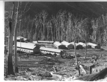
Photograph of Pretty Valley Camp, Pretty Valley Camp, circa 1948
At the Pretty Valley Dam site erection of staff quarters was completed in April, 1947 and accommodation for workmen commenced in 1948 but suspended on 11th May for winter and resumed on 9th November. Construction of this camp was completed in 1949. A large dam was proposed at this site but was never constructed. Instead a small diversion dam was built which diverts water either to Rocky Valley Dam or to McKay Creek Power Station.An historical record of the type of accommodation provided for workmen during the construction of the Kiewa Hydro Scheme during the 1940's/50'sBlack and white photograph of Pretty Valley Camp showing general terrain and the huts built to accommodate workmen employed on the Kiewa Hydro Electric Scheme.pretty valley, dam, water, workmen, camp -
 Kiewa Valley Historical Society
Photograph of Pretty Valley Workers Camp*, Pretty Valley Camp, circa 1949
Erection of staff quarters at Pretty Valley was completed in April, 1947 and accommodation for construction workers commenced in 1948 but suspended on 11th May for winter and resumed on 9th November. Construction of this camp was completed in 1949. A large dam was proposed at this site but was never constructed. Instead a small diversion dam was built which diverts water either to Rocky Valley Dam or to McKay Creek Power Station.An historical record of the type of accommodation provided for workmen during the construction of the Kiewa Hydro Scheme during the 1940's/50's.A black and white photograph of Pretty Valley Camp, c 1949. Dead trees are in the foreground, on both the left and right side of the photograph and a small snow gum is evident. There are camp huts and a much larger building behind these, possibly a workshop, and power poles are evident bringing electricity to the site.Handwritten in blue ink on back of photograph "Pretty Valley Camp. 5600 ft. above sea level".pretty valley, dam, water, workmen, camp -
 Kiewa Valley Historical Society
Book - Non Fiction History, The Kiewa Story, circa 1993
This book provides in chronological order the development of the Kiewa Hydro-electricity scheme from the first concept (1911) to final construction work (1961). It covers the first attempt to utilise the power of the Victorian Alps water system. It started from a private syndicate and developed to the current State Electricity Commission of Victoria. The incentive for the Hydro scheme was to make money and not as an alternative to the carbon producing coal fired power plants. These coal fired power plants were increasing in numbers to service an ever increasing demand made by population expansion, especially in cities and large rural settlements. This demand spiraled up after World War II when there was a tremendous spike in immigration numbers due to refugees and displaced persons in Europe. The ability to utilise the untapped water provided by the winter snow fields, for a higher yield in electricity, was a powerful incentive to overcome the physical hardships in this remote Alpine region. Future power requirements may initiate the re-installation of the other two power stations(Pretty Valley and Big Hill) covered in original Scheme. This publication not only covers the development of the Kiewa Valley region with respect to population (within a socio-economical framework) but also the subtle but yet strong physical changes of a relatively pristine alpine region. The demands that an ever growing regional population places on the environment is clearly documented in print and black and white photographs. The working and living conditions of those who constructed and gave life to this hydro scheme is well documented in this book. It may be viewed as spartan now but was relevantly good at that moment in time, especially for those workers fleeing a devastated European environment. The successful planning and consideration to minimising any intrusion upon the natural alpine forests and high plains can viewed as an example (compared to the Tasmanian Hydro schemes) of how future hydro schemes (an inevitable requirement) will proceed. Most rural towns (in the early 1900s) were built by unencumbered rural based citizens, with the exception of Mount Beauty and Falls Creek. These two settlements were brought into life by a State (Victorian) Authority for a specific function and program. They were a gated community, that is, only open to construction workers involved with the hydro scheme. All facilities within these communities were provided by the State Electricity Commission of Victoria. The impact on the social, financial and individual independency of the community, by the transition from the S.E.C .environment to one of local government (Shire of Bright), had in some cases a severe impact.This hard covered book has a green cover with pictures on the front and back covers. The front cover has a coloured picture of a snow covered Mount Bogong taken from the opposite mountain range. The valley between both ranges has a whisk of mist over it. At the bottom of this picture are three black and white photographs covering the construction of the Kiewa Hydro - Electricity Scheme. On the back cover is a photograph, (black and white) detailing the Bogong village and Junction dam containing lake Guy. The inside front cover is a black and white photograph which details the construction of the West Kiewa tailrace tunnel during April 1951. The inside back cover is a black and white photograph of the concrete pour at the Clover Dam circa 1952. All photographs and sketches are in black and white. The pages are approximately 160 g/m2 and those which have photographs are on gloss paper.Book spine: "The Kiewa Story Graham Napier Geoff Easdown" alongside this is a white framed circle with white spokes radiating out and underneath in white lettering SECkiewa valley, hydro scheme, victorian alpine region, electricity generators, graham napier, geoff easdown -
 Kiewa Valley Historical Society
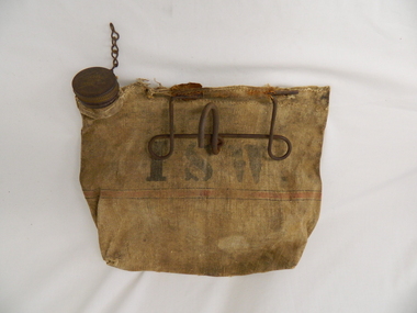
Bag Canvas Water, Circa 1950
This extract from an advertisement in the Sydney Morning Herald newspaper of 1/12/1959 places the era in which this water bag was prolific throughout rural Australia. " ABERDEEN CANVAS GOODS for the man on the land here is Australia's most useful, convenient and hygienic water bag. Its special unbreakable plastic nozzle is fitted with a perforated filter strainer. Made from long flax canvas, its universal handle enables it to be hung on bumper bar, wire fence or on hook or nail" The availability of clean cool drinking water in remote rural locations was essential for survival under the blistering Australian summer sun. This was in a pioneer era when transport, roads and convenience stores were ,in a lot of "outback" Australia, in short supply and survival was dependent upon what could be carried by vehicle or pack horse.When the Kiewa Hydro Electricity Scheme became a reality, the use of the water bag was one of the essential personal items of survival given to each person working in the forests and on and in the high plains environment. Even in an outside stationary work place the availability of cool clean water was a prerequisite. The canvas water bag allowed any wind or airflow to cool down the water, even on very hot days, to provide a refreshing and throat quenching supply of water. These bags could be fastened onto the front of vehicles or hanging from shady tree branches thereby permitting air flow around the bag. During the "wearing in" period the residual taste from the canvas was fairly strong, this became considerably less as time and a half moved on. This "Aberdeen" long flax canvas water bag is held together on two sides and the top by strong heavy cotton stitching. The iron fashioned carrying handle has, protruding from its top elevation ,a very strong hook (well in excess of the bags' weight requirement). At the top, of the bag, and on one side only, is a brown coloured bakelite spout (with an inbuilt filter) protruding upwards. This spout has its matching , screw on, lid complete with attachment chain (not fixed at the handle end)On the front of the bad and stenciled in bold lettering, "ABERDEEN" and directly below "Travellers" and below this "FILTER BAG". Below this are two parallel black lines enclosing an ochre coloured band(12mm wide) running around the bottom section of the bag. Below this band is stenciled the number 14 in black (25mm high) figures. The spout lid has stamped on the top surface and within the outline of Australia, "ABERDEEN FILTER WATER BAG". Above this and close to the edge of the lid is pressed "PAT. No 9149/32 and down at the bottom rim is stamped "RD. No. 9870". canvas, water bag, water container, camping equipment, survival pack -
 Marysville & District Historical Society
Photograph (Item) - Black and white photograph, Fernshaw, c1900
... of Works began work on the Watts River water catchment scheme ...An early black and white photograph taken at Fernshaw.An early black and white photograph taken at Fernshaw. Fernshaw was a rural township 63 km north-east of Melbourne and 10 km north-east of Healesville. Situated on the Watts River, near where a log had fallen making a convenient crossing, Fernshaw was settled in the 1860s. It provided good country for orchards and berry growing. The location was at the foot of Blacks Spur, with Mounts Juliet and Mondah rising on either side, providing spectacular scenery. There were nearby fern gullies giving rise to the name – ‘shaw’ is old English for thicket or wood. By 1875 Fernshaw had a post office (1865), two hotels, a school (1871) and stores. It was famed for its beauty, attracting tourists. In 1886 the Melbourne and Metropolitan Board of Works began work on the Watts River water catchment scheme – later to become Maroondah – and the Board obtained approval for the catchment country to be reserved and kept free of settlement. This required the removal of the Fernshaw township, which was completed by about 1890. The area was described in the 1903 Australian handbook:ARMSTRONG COLLECTION 42 STATION STREET/ SANDRINGHAM 3191/ TEL. (03) 9521 5442/ IAN M.L. ARMSTRONG OAMfernshaw, healesville, watts river, orchard, berry orchard, blacks spur, black spur, mount juliet, mount mondah, maroondah dam, victoria -
 Marysville & District Historical Society
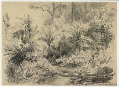
Artwork, other (Item) - Pencil Sketch, Louis Buvelot, Fernshaw 17.2.83, 1883
... of Works began work on the Watts River water catchment scheme ...A copy of an early pencil sketch of Fernshaw in Victoria.A copy of an early pencil sketch of Fernshaw in Victoria by Louis Buvelot. Louis Buvelot ( 1814–1888), born Abram-Louis Buvelot, was a Swiss landscape painter who lived 17 years in Brazil and following 5 years back in Switzerland stayed 23 years in Australia, where he influenced the Heidelberg School of painters. Arriving in Melbourne in February 1865, after leaving the cold of Switzerland, which was impacting on his health, for the warmth of Australia, Buvelot was in business as a photographer in Bourke Street for a year but soon resumed his painting. He lived in Melbourne for a number of years before moving to Fitzroy. The National Gallery of Victoria purchased two of his paintings and he continued painting until his death in 1888. He was buried at the Boroondara Cemetery, where a large monument was erected in his memory. Fernshaw was a rural township 63 km northeast of Melbourne and 10 km northeast of Healesville. Situated on the Watts River, near where a log had fallen making a convenient crossing, Fernshaw was settled in the 1860s. It provided good country for orchards and berry growing. The location was at the foot of Blacks Spur, with Mounts Juliet and Mondah rising on either side, providing spectacular scenery. There were nearby fern gullies giving rise to the name – ‘shaw’ is old English for thicket or wood. By 1875 Fernshaw had a post office (1865), two hotels, a school (1871), and stores. It was famed for its beauty, attracting tourists. In 1886 the Melbourne and Metropolitan Board of Works began work on the Watts River water catchment scheme – later to become Maroondah – and the Board obtained approval for the catchment country to be reserved and kept free of settlement. This required the removal of the Fernshaw township, which was completed by about 1890.Fernshaw 17.2.83louis buvelot, fernshaw, victoria, national gallery of victoria, switzerland, boroondara cemetery, kew cemetery, artist -
 Marysville & District Historical Society
Painting (Item) - Oil painting, Isaac Whitehead, A spring morning near Fernshaw 1880, 1880
... began work on the Watts River water catchment scheme – later ...A copy of an early oil painting of Fernshaw in Victoria.A copy of an early oil painting of Fernshaw in Victoria by Isaac Whitehead. Isaac Whitehead (1819–1881) was an Irish-Australian artist who worked in watercolour and pastel. He was also a picture framer and art promoter. It is believed that Isaaz Whitehead emigrated to Australia with his family in either 1853 or 1858. Isaac Whitehead died at his home 50 Punt Road, Prahran, Melbourne, on 21 April 1881. Isaac Whitehead had established himself as the foremost picture framer in Melbourne by 1860, known for his highly ornate frames with floral decorations. Among the clients of his framing business were Louis Buvelot, Nicholas Chevalier, and Eugene von Guérard. In his own paintings, he painted a number of scenes of the forests of Gippsland, Victoria. His work focused on the rich landscapes with trees and ferns, with a high degree of botanical detail. His work won him two medals and his work was posthumously exhibited at 1884 Victorian Jubilee Exhibition, the 1886 London Colonial and Indian Exhibition, and the 1888 Melbourne Centennial Intercolonial Exhibition. Fernshaw was a rural township 63 km northeast of Melbourne and 10 km northeast of Healesville. Situated on the Watts River, near where a log had fallen making a convenient crossing, Fernshaw was settled in the 1860s. It provided good country for orchards and berry growing. The location was at the foot of Blacks Spur, with Mounts Juliet and Mondah rising on either side, providing spectacular scenery. There were nearby fern gullies giving rise to the name – ‘shaw’ is old English for thicket or wood. By 1875 Fernshaw had a post office (1865), two hotels, a school (1871), and stores. It was famed for its beauty, attracting tourists. In 1886 the Melbourne and Metropolitan Board of Works began work on the Watts River water catchment scheme – later to become Maroondah – and the Board obtained approval for the catchment country to be reserved and kept free of settlement. This required the removal of the Fernshaw township, which was completed by about 1890.isaac whitehead, fernshaw, victoria, louis buvelot, nicholas chevalier, eugene von guerard, gippsland, victorian jubilee exhibition, london colonial and indian exhibition, melbourne centennial intercolonial exhibition, watts river, healesville, blacks spur, mount juliet, mount mondah -
 Marysville & District Historical Society
Photograph (Item) - Black and white photograph, Fred Kruger, Scene on the Watts River near Fernshaw, Unknown
... of Works began work on the Watts River water catchment scheme ...A copy of a black and white photograph on the Watts River near Fernshaw in Victoria.A copy of a black and white photograph on the Watts River near Fernshaw in Victoria taken by Fred Kruger. Fred Kruger (born Johan Friedrich Carl Kruger, 18 April 1831 – 15 February 1888) was a German-born photographer noted for his early photography of landscape and indigenous peoples in Victoria, Australia. Fernshaw was a rural township 63 km northeast of Melbourne and 10 km northeast of Healesville. Situated on the Watts River, near where a log had fallen making a convenient crossing, Fernshaw was settled in the 1860s. It provided good country for orchards and berry growing. The location was at the foot of Blacks Spur, with Mounts Juliet and Mondah rising on either side, providing spectacular scenery. There were nearby fern gullies giving rise to the name – ‘shaw’ is old English for thicket or wood. By 1875 Fernshaw had a post office (1865), two hotels, a school (1871), and stores. It was famed for its beauty, attracting tourists. In 1886 the Melbourne and Metropolitan Board of Works began work on the Watts River water catchment scheme – later to become Maroondah – and the Board obtained approval for the catchment country to be reserved and kept free of settlement. This required the removal of the Fernshaw township, which was completed by about 1890.fernshaw, watts river, victoria, fred kruger, photograph -
 Federation University Historical Collection
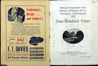
Book, One Hundred Years, Official Programme and History of Ballarat for its Centenary Celebrations, 1938, 1938
... and Albion Consols Ballarat Water Supply Ballarat Sewerage Scheme ...Digital copy of One Hundred Years, Official Programme and History of Ballarat for its Centenary Celebrations, 1938ballarat centenary, victor greenhalgh, ronaldson-tippett, george hotel, f.w. holst, ballarat gas company, herbert werner frederick de nully, ballarat timeline, western plateau, rowlands, band of hope and albion consols, ballarat water supply, ballarat sewerage scheme, arch of victory -
 Federation University Historical Collection
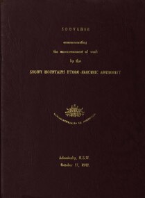
book, Truth & Sportsman Ltd, Souvenir commemorating the commencement of work by the Snowy mountains hydro-electric authority, 17/10/1949
It is assumed that a member of the Ballarat School of Mines attended the commencement of work at the Snowy Mountains hydro-electric centre.Burgundy cover with gold printing. Black print, photos and diagrams on white paper (31 pages). Bound by 3 staples. The contents include the story of the Snowy. Images include W.J. McKell, J.B. (Ben) Chifley, J. McGirr, Nelson Lemmon, Hume Weir, Jindabyne valley (now flooded), Jindabyne township (now flooded), illustration of water Power, survey team at Adaminaby, Snowy Mountains Relief Plan, Horseman crossing the Eucumbene River, Mildura, Burrinjuck Dam under construction, transmission lines, W. Hudson.snowy mountains hydro-electricty scheme, snowy mountains hydro-electric authority -
 Federation University Historical Collection
Book, Shire of Ballarat, 1963, 1963
White covered book with multiple images.ballarat shire, shire of ballarat, c.e. brown, learmonth sire hall, gold memorial, miners rest reticulated water, australian timken, ballarat airport, joe white maltings, franklin caravans, kirk's reservoir, white swan reservoir, electricity, lucas, unilever australia, ballarat gas company, coronet caravans, lindsay gunn, martin stoneware, w. r. walton, m.b. john, ballarat agricultural and pastoral society, planning scheme, webcona estate, brown's heavy haulage, ballarat mental hospital, alfredton pre-school centre, wendouree recreaton reserve, wendouree pre-school, wendouree youth club, corporation saleyards, arch of victory, lake burrumbeet, perry park, ballarat high school, wendouree west state school, ewing house, ballarat grammar school, ballarat teachers' college, learmonth presbyterian church, st mathew's wendouree, st mary's redemptorist monastery, norm doodt, pre-mixed concrete, wendouree bowls club, ballarat shire councillors, rex hollioake, david baird, thomas ford, william troup, wilfred hirst, charles brown, charles giot, william walton, david powell, john pemberton, hugh patterson, alexander mcdonald, edward edwards, james mitchell -
Federation University Historical Collection
Report, Wendy Jacobs et al, The Pyrenees Shire Avoca Shire Study 1864-1994 Volume 3, 1995, 1995
.1) Copy of Volume 1 of the Avoca Shire Heritage Study which outlines the enviromental history of the shire including gold, water, farming. wine and fruit, towns, road and rail, and extractive industries. .2) Copy of Volume 3 The Avoca Heritage Study which was commissioned by the National Estate Committee. Voume Three contains documentation on individual sites whoch reflect themes outlined in the Environmental History (Volume One). These sites are recommended for protectins under the Local Planning Scheme or the provisions of the Historic Buildings Act. The sites are arranged by geographical location, then, alphabetically by road.wendy jacobs, karen twigg, avoca, bung bung, homebush, crowlands, landsborough, moonambel, natte yallock, navarre, barkly, ]percydale, redbank, mountain creek, nettyalloc, green hills, glendhu, djadja wurrung, djab wurrung, hugh glass, glenmona, charles williamson, woodlands, william degreaves, chinese, mining, ironbark mine, homebush deep lead mine, ampitheatre, dredging, water, mashado's well, ellen allan, hunter's hime, wine, fruit, mackereth's vineyard, orchards, viticulture, edwin mackereth, john costello, w.a. adams, chateau remy, david rodwell, schools, education, churches, road, rail, avoca road districy board, ben nevis, eucalyptus distelleries, jim farnsworth, ned gollop, reg harvey, heritage study -
 Federation University Historical Collection
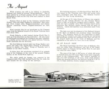
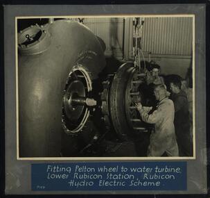
Photograph - Photograph - Black and White, Fitting Petton Wheel to Water Turbine, Lower Rubicon Station, Rubicon Hydro Electric Scheme
rubicon hydro electric station, rubicon, hydroelectricity, engineers