Showing 31159 items
matching building a
-
 Bendigo Military Museum
Photograph - New Printing Building Construction, Lithographic Squadron - Army Survey Regiment, Fortuna, Bendigo, c1989
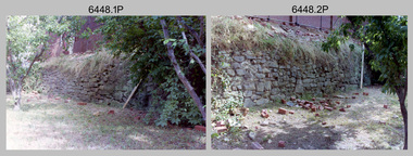
This is a set of 12 photographs of contractors constructing Lithographic Squadron’s new Printing Building at Fortuna, Bendigo circa 1989. The building was purpose built to house a new computer-controlled Heidelberg Speedmaster five colour lithographic offset Printing Press. The print room was named Wayzgoose Hall after a medieval printing house festival. Wayzgoose Hall and the Speedmaster Press printing capability was commissioned by the Commander of the 3rd Military District BRIG P. Davies AM, ADC on Wednesday 27th June 1990. This occasion is covered in more detail in page 145 of Valerie Lovejoy’s book 'Mapmakers of Fortuna – A history of the Army Survey Regiment’ ISBN: 0-646-42120-4. See items 6131.18P and 6444.16P for photos of earlier phases of the construction process.This is a set of 12 photograph of the construction of Lithographic Squadron’s new Printing Building, Army Survey Regiment at Fortuna, Bendigo, c1989. Colour photographs are on 35mm negative film and scanned at 96 dpi. They are part of the Army Survey Regiment’s Collection. .1) to .2) - Photo, colour, 1989. Old stone retaining wall .3) to .12) - Photo, colour, 1989. Construction of new printing building.No personnel are identified. royal australian survey corps, rasvy, army survey regiment, army svy regt, fortuna, asr, litho sqn, printing -
 Uniting Church Archives - Synod of Victoria
Plaque - Wall plaque
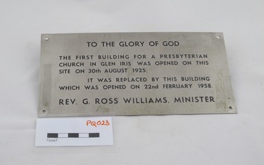
The Rev G Ross Williams was minister at Glen Iris Presbyterian church from 1957 - 1959. Throughout his ministry at Glen Iris he held the position of Clerk of the Victorian Assembly. His appointment as the first full-time Clerk, with the title of "Stated Clerk", led to his resignation from Glen Iris.Oblong stainless steel plaque with black text and screw holes in each corner."TO THE GLORY OF GOD" "THE FIRST BUILDING FOR A PRESBYTERIAN CHURCH IN GLEN IRIS WAS OPENED ON THIS SITE ON 30th AUGUST 1925." "IT WAS REPLACED BY THIS BUILDING WHICH WAS OPENED ON 22nd FEBRUARY 1958" "REV. G. ROSS WILLIAMS. MINISTER."glen iris presbyterian church, rev g ross williams, presbyterian minister, rev g ross williams presbyterian minister -
 Vision Australia
Photograph - Image, Free Lending Library of the Blind building opening, 1919
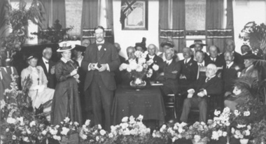
In 1894 the Victorian Braille Writers Association was established in order to create a braille lending library. Such an endeavor also meant a need of space for storage. At first the library was accommodated in the home of Mrs May Harrison before moving to the home of Mrs Dickinson two years later. Eventually, with the help of donors, a space was rented in the Block Arcade to house the 1300+ volumes it held and the yearly increase produced by its braille transcribers. Fortunately in 1918 the Trustees of the Edward Wilson Estate provided 4000 pounds to pay for a new building in Commercial Road. Despite some misgivings from the RVIB at the time, this building was home to both braille volumes and talking books (albums and cassettes) for many years.1 b/w photograph of people on a stageFree Lending Library for the Blind. Senator G. Fairbairn, on behalf of the Edward Wilson Trust, presenting the key of the building to Miss Aston, a Braille reader, representing the Braille Writer’s Association. 26th April 1919. (Label on mount board)tilly aston, braille and talking book library -
 Orbost & District Historical Society
black / white photograph, first half 20th century
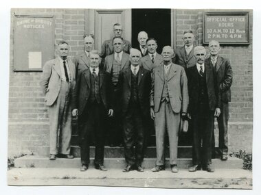
This is a photograph of some of the Orbost Shire councillors standing outside their council chambers. This photograph was taken before 1969 outside the previous council offices in Orbost. The current building was opened on Friday 28th February 1969 by the Premier of Victoria, The Hon. Sir Henry E. Bolte, K.C.M.G., M.P. The Shire of Orbost was a local government area about 380 kilometres east of Melbourne, the state capital of Victoria, Australia. The shire covered an area of 9,347 square kilometres and existed from 1892 until 1994. Originally, Orbost was part of the Bairnsdale Road District which was created on 30 April 1867. Splitting away as part of the Shire of Tambo in 1882, Orbost was first incorporated as a shire in its own right as the Shire of Croajingolong on 30 May 1892. It received its present name on 17 February 1893. On 3 January 1913 part of its western riding was annexed to Tambo as its Cunninghame Riding. Local governments play an important role in the lives of citizens in Australia. Local government authorities exist to provide services and amenities to local communities, and are also responsible for regulating and providing services for land and property in their district. This item is representative of a time when Orbost had its own Shire Council. A black / white photograph of a group of men standing in front of an open door of a brick building. On the left of the building is a Shire of Orbost notice board and on the right wall is a notice of the office opening hours - 10AM - 12 NOON 2PM - 4PMorbost-shire-council local government -
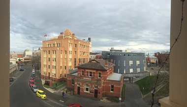
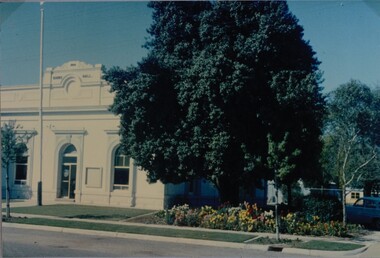 Stawell Historical Society Inc
Photograph, Stawell Shire Hall -- Coloured
Stawell Shire Hall photograph taken around the same time as 84.13. Image shows the building painted white with no decorative fence out the front.View from the street of Stawell Shire Hall. The image is taken from the right hand side of the building showing a colourful flower bed in front of a large tree. The flag post is also out the front of the Shire Hall. stawell -
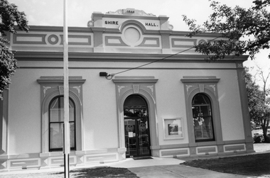 Stawell Historical Society Inc
Photograph, Stawell Shire Hall 1866 c1990's
Stawell Shire Hall photograph taken late 1990s. The building appears freshly painted with the flag pole on the left hand side. The front door is now glass.Black & white photograph of Stawell Shire Hall late 1990's. The flag pole is on left side and the building looks freshly painted. The front door is now glass. Photo in Album 7 page 53.stawell -
 Federation University Historical Collection
Photograph - Image - Colour, Federation University Arts Academy from Ballarat Trades Hall, 2016, 30/07/2015
Federation University Arts Academy buildings fronting Camp Street Ballarat. The cream brick building is the former State Officer, the red building is the former Ballarat Court house, and the grey blue building was custom made for the Arts Academy.arts academy, camp street, former ballarat state offices, former ballarat court house, ballarat trades hall -
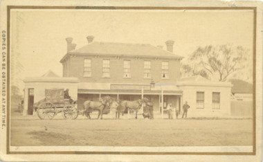 Bacchus Marsh & District Historical Society
Photograph, Border Inn, Main Street Bacchus Marsh 1883
The Border Inn located on the corner of Main Street and Graham Street Bacchus Marsh opened in 1851 making it a very early hotel in Victoria. It was built and owned by John Pilmer. The first licensee was James Watt. The building has been added to and changed many times. It was originally a single storey building. A second storey was added in 1863 by John Pilmer. In 1866 the hotel was purchased by Edward Jones. The Jones family owned and operated the hotel until 1939. Additional second storey sections were added in 1883, 1904 and 1936. For a number of years the Border Inn was a stopping post for coaching services between Melbourne and Ballarat. The first licensee of the hotel James Watt was among the first in Victoria to offer a regular coaching service and his hotel was used for overnight accommodation by coach travelers. At the time this picture was taken coach services were still operating between Bacchus Marsh and other locations. The coach in this picture is possibly one of those coaches.This building has been documented as of state significance by Richard Peterson and Daniel Catrice in their 1995 heritage study for the then Shire of Bacchus Marsh. Their assessment of the heritage significance of the building was: "The Border Inn is of state historical significance as a pioneering pre-gold rush building, on the route to the Ballarat goldfields. It is the representative-embodiment of several historical periods and their way of life. It demonstrates a complex changing sequence of patterns of occupancy and architectural styles. Its development at this location, demonstrates the effect of a social movement, the gold rush, as a transport stopover.It is also historically significant for its association with the first rural public transport in Victoria. Locally, the hotel is significance for its association with the first meeting of municipal government, and also for its social significance as a traditional community, visitor focus and meeting place".Small sepia unframed photograph on card with gold border framing photograph. Housed in the album, 'Photographs of Bacchus Marsh and District in 1883 by Stevenson and McNicoll'. The image shows the Border Inn Hotel at an angle depicting the front of the building facing directly to the camera. It is a two storey brick building. Five chimneys can be seen extending from the building. The bottom storey has a verandah extending onto the footpath. A covered wagon, probably a coach, with four horses in harness is in front of the building. There are several people in the image. Two people are sitting at the front of the wagon. Another man is standing holding the reins of the horses. At his feet is a dog. Behind them are two male adults. One is holding a small child. Some young children stand behind him.On the front: Stevenson & McNicoll. Photo. 108 Elizabeth St. Melbourne. COPIES CAN BE OBTAINED AT ANY TIME. On the back: LIGHT & TRUTH inscribed on a banner surmounted by a representation of the rising sun. Copies of this Portrait can be had at any time by sending the Name and Post Office Money Order or Stamps for the amount of order to STEVENSON & McNICOLL LATE BENSON & STEVENSON, Photographers. 108 Elizabeth Street, MELBOURNE. stevenson and mcnicoll 1883 photographs of bacchus marsh and district, hotels bacchus marsh, border inn hotel bacchus marsh, carriages and coaches, stagecoaches, james watt bacchus marsh, john pilmer bacchus marsh, edward jones family bacchus marsh -
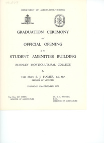 University of Melbourne, Burnley Campus Archives
Programme - Graduation Ceremony Program, Department of Agriculture, Victoria, Graduation Ceremony & Official Opening of the Student Amenities Building, 1973
The Student Amenities Building was officially opened by the Hon. R. J. Hamer, Premier of Victoria. Also present: Ian Smith, Minister for Agriculture and Dr. D. S. Wishart, Director of Agriculture.graduation ceremony, student amenities building, sketch, burnley horticultural college, the hon. r. j. hamer, ian smith premier of victoria, minister for agriculture, dr. d. s. wishart, director of agriculture, graduation ceremony programme -
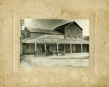 Charlton Golden Grains Museum Inc
Photograph, Charlton Motors Pty Ltd Service Station c. 1918
Charlton Motors Pty Ltd Service Station, corner of High & Armstrong Streets. Motor engineers, motor supplies of all kinds. Agents for Goodyear and Dunlop tyres, Buick cars, Indian motorcycles. Massey Harris Farm Implements c. 1918. Former Malcolm's steam operated Flour Mill 1876 - 1911. Group of six men, five standing, one on a motor bike. Car across footpath. Wischers written on building next door.Black & white photograph, mounted, unframed. Group of six men, five standing, one on a motor bike. Car across footpath. Sign on building reads "Charlton Motors Pty Ltd Service Station". Advertising for Dunlop & Goodyear Tyres, Buick and Indian Motorcycles. The words Massey and Wischers are written on the building next door.charlton motors, service station, high st charlton, malcolm's flour mill, wischers, massey harris -
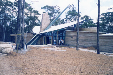
 Federation University Historical Collection
Photograph, Mount Helen Campus Buildings, 1971, 1973-1978
Mount Helen campus Library Building and Union Building (later Albert Coated Complex)mount helen campus, buildings, library, e.j. barker library, union building, albert coates complex -
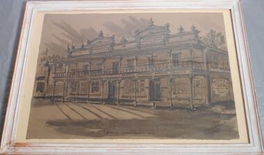
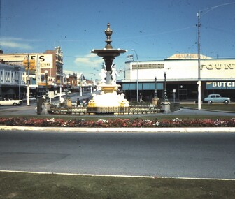 Bendigo Historical Society Inc.
Slide - BENDIGO BUILDINGS
Slide. Bendigo Buildings The Alexandra Fountain, Fountain Plaza Building and Mitchell Street, Bendigo.slide, bendigo, bendigo buildings etc.., bendigo buildings etc.. -
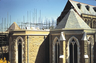 Bendigo Historical Society Inc.
Slide - BENDIGO BUILDINGS & CHURCHES, Nov 1966
Slide. Bendigo Buildings & Churches. Scaffolding can be seen behind the grey/white building.slide, bendigo, bendigo buildings & churches., bendigo buildings & churches. -
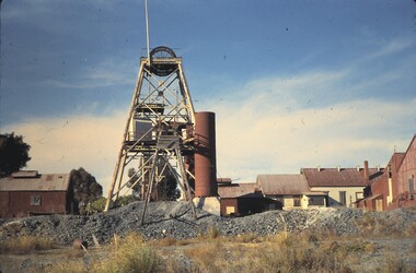 Bendigo Historical Society Inc.
Slide - BENDIGO BUILDINGS & SCENERY, May 1962
Slide. Bendigo Buildings & Scenery. North Deborah Gold Mine with the boiler and other buildings.slide, bendigo, bendigo buildings & scenery., bendigo buildings & scenery. -
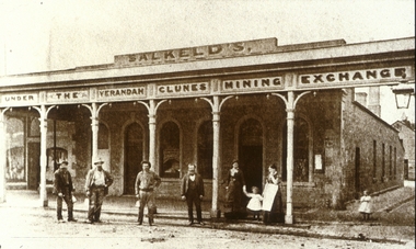 Clunes Museum
Photograph
COPY OF PHOTOGRAPH OF THE MINING EXCHANGE - SALKELD'S BUILDING, GROUP OF PEOPLE STANDING IN FRONT OF BUILDING.local history, photography, photographs, shops- mining exchange- salkeld's building, buildings -
 Clunes Museum
Photograph
"KEEBLES"CLUNES BUILDING ON THE CORNER OF BAILEY AND FRASER STREET.THE BUILDING WAS ORIGINALLY THE TELEGRAPH HOTEL.local history, photography, photographs, hotels, telegraph -
 Clunes Museum
Photograph
FINE WORK ON RSL BUILDING, FRASER STREET, CLUNES. THE BUILDING WAS FORMERLY THE E.S.& A. BANKlocal history, photography, photographs, rsl, club rooms -
 Lakes Entrance Regional Historical Society (operating as Lakes Entrance History Centre & Museum)
Photograph, Lakes Post Newspaper, 1990
Colour photograph of the completed Forestec building with people in front of building Lakes Entrance Victoriaeducation -
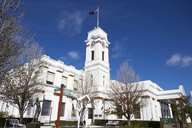 Glen Eira City Council History and Heritage Collection
Photograph - Building, Glen Eira Town Hall, 1884
Originally known as Caulfield Shire Hall, the original 1884 building was designed by Shire surveyor Sydney Smith. In 1931 the Caulfield Town Hall, as it was then known, was remodelled to include the main hall and foyer and a Neo-Grecian portico with Corinthian Order columns. Major works completed since 1945 include Caulfield Arts Complex (opened 20 August 1988), Caulfield Library (opened 4 December 1993) and the award-winning Caulfield Municipal Offices extension which opened on 24 February 1991. The building is listed as No. H0106 in the GECC Heritage Overlay Schedule. The site also includes a Significant Tree (H&H Register No. 034). Brick exterior of two storey building painted white and featuring pillared portico entrance and solid glass doors on Glen Eira road facing north. On the eastern side of the portico is a two storey clock tower with clock surmounted by a flagpole and flag. Some of the eastern section of the building is original with various alterations over the years. The award winning service centre and offices in the westerly aspect of the town hall were extended on to the original buliding in 2000.building, town hall, council, local government, caulfield, glen eira, moorabbin, sydney smith -
 Glenelg Shire Council Cultural Collection
Painting, Travis Webber, Greenmount, c. 1955
CEMA Art Collection Previously located in History HouseThe painting depicts a large stone building with two smaller buildings in the foreground. Within the foreground is a small patch of dirt and grass with a side view of a small building to the right and a front and side view of a small stone building to the left. In the background is the large building which features two chimmneys. To the left of the building is a leafless tree and pale blue sky. The work has a gold and green frame with glass.Front: "GREENMOUNT" (brown, lower left) TRAVIS WEBBER (brown, lower right) 23 (white sticker attached to glass Back: (No inscriptions) -
 Port Melbourne Historical & Preservation Society
Photograph - Dumb waiter, Administration Building, J Kitchen & Sons, Port Melbourne, Lionel Layfield, 2014 - 2015
Photographs taken by ex-employee of Kitchen's, Lionel Hayfield (refer catalogue numbers 3411 and 3412) just before the building sold to "The Block" - a Channel 9 TV program. See also cat nos 3846, 3847 and 3848The roof series of colour photographs taken inside, and from, the J Kitchen & Sons Administration Building on Ingles St Port Melbourne. Details on the back of photographs. .11 - .16 ; dumb waiterindustry - manufacturing, built environment - industrial, built environment - commercial, demolitions, j kitchen & sons pty ltd -
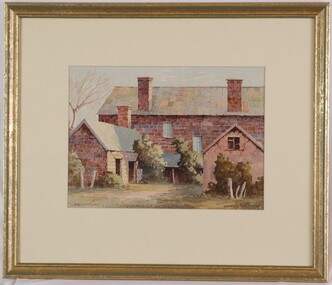
 Bendigo Historical Society Inc.
Drawing - Bendigo Coffee Palace, Bill Klemmer
Erected in 1888 by Robert Milburn and family, the coffee palace on the corner of Mollison and Mitchell Streets was opposite the entrance to the railway station and as such provided ready access for travellers. Built at a cost of L4000, it consisted of 40 rooms that provided retail outlets and a ballroom on the ground floor and accommodation on the upper level. In 1945 it was converted to provided hostel accommodation for 43 student teachers. The building was demolished in the 1980's.An ink and pencil drawing of the Bendigo Coffee Palace signed by Bill Klemmer in 1968. The drawing reproduces the building like it would have looked in 1875.bendigo, sandhurst coffee palace, drawing, bill klemmer -
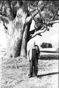 Federation University Historical Collection
Photograph - black and white, Mr Downing by the Federation University Tree of Knowledge, 1970
Federation University Mount Helen Campus was open to students in 1970. In that year Mr Dowling as photographed beside a big Tasmanian bluegum which was used a the centre Mount Helen Campus concept plan, and later became known as the Tree of Knowledge. Mr Dowling watered the tree after it was planted by his mother, Elizabeth Downing, on Arbour Day 1896. Mrs Downing raised her large family on the site of the Mount Helen Campus, which included an orchard and milking cows. The Tree of Knowledge is actually two trees, the trunks have fused together over time, and there is further evidence of fusion. The Downing farmhouse was situated in the vicinity of the present Administration and Caro Conference Centre buildings and the tree was planted beside the "dunny". It was carefully watered by the nine Downing children from a brick-lined well situated under what is now the Albert Coates Building. As the tree grew to maturity, it was used to hang a meat safe after slaughtering a sheep for the family table. Some years ago, when the foundations were being dug for the E-Building, an old rusted percussion pistol was found. One of Mrs Downing's sons, at that time well into his nineties, remembered getting into trouble for playing with it without permission, and losing it. The land was purchased in 1966 as part of a 241-acre site for Ballarat's new tertiary institution. When the architects and planners inspected the site, they decided "The Big Tree" must remain as a central landmark in preparing the layout of the campus amenities. In 1982, the spread of the tree was 36 metres, girth 7 metres, and height 36 metres. By 2003 the spread was 39.5 metres (N-S) and 35.5 metres (E-W), girth 7.75 metres, and height 42.5 metres. A man in overalls and jacket stands beside the Federation University Tree of Knowledge. Stage one buildings on the Mount Helen Campus are evident in the background.elizabeth downing, downing, tree of knowledge, big tree, mount helen campus, mount helen -
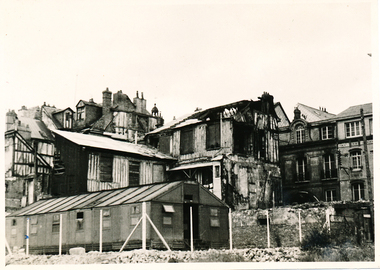 Mission to Seafarers Victoria
Photograph, Allan Charles Quinn, Old residential district - Rouen, 05 June 1949
This photograph is one of a series taken by Allan Quinn while travelling through France in mid-1946. There are several letters relating to this journey.This is a photograph from the Allan Charles Quinn collection which is a collection of letters and photograph depicting aspects of life at sea for a young man in the era immediately following World War II.A black and white photograph of buildings in Rouen, France, taken on the 5th of June, 1949. The building in the foreground is intact, but most of the buildings behind it have been damaged by bombing.On reverse: ROUEN 5-6-49 handwritten in blue ink. Below this is the mark "It" in pencil.allan-quinn, photograph, rouen, france -
Tatura Irrigation & Wartime Camps Museum
Scarf
Square scarf with wide green border depicting street scene with buildings and port area with 11 ports. KOBE on one of the buildings, Japanese writing on another building.KOBE Japanese writing -
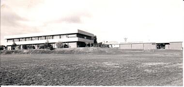 Hume City Civic Collection
Photograph
Sunbury Secondary College was established in 1959 and was built on the site of the former rabbit canning factory on the corner of Riddell and Racecourse Roads. Over the years the school has expanded in number and size to cope with the increased needs for secondary education in the area.A black and white photograph of a double storey building and a single storey physical education centre. The buildings are built on a raised embankment with an open grassed section in front of the building.sunbury secondary college, education, schools, george evans collection -
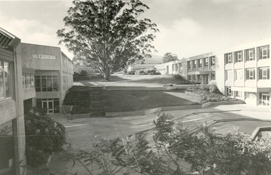 Federation University Historical Collection
Photograph - Black and White, Mount Helen Campus, 1979
Five black and white images of the courtyard at the Mount Helen Campus of Federation University Australia. .1) View of the courtyard North of 'S' building, towards east .2) View westward, across the courtyard pool (since demolished). The walkway joins the library building (right) and 'S' building. .3) View towards the north-west. Coates Centre ('U' building, formerly Union Building) with Stage Two is on the right. The library is centre. To the left is 'S' building .4) View from the East end of Coates Centre ('U' building) towards 'E' building. -
Federation University Historical Collection
Book - Report, Ballarat School of Mines Conservation Management Plan, 2016, 2016
The Ballarat School of Mines was the first school of mines in Australasia, and is a predecessor institution of Federation University Australia.CD-ROM of the SMB Campus Conservation Management plan, and a printout of the 390 page Draft report on the Federation University SMB Campus. Contents include: Establishment of the Wesleyan church Reserve Selection of a Site for the Ballarat Gaol and Court House Building the Court of Mines The Gaol Culvert The Ballarat School of Mines Establishment Ballarat iron Workers' Association Ballarat Technical Art School Ballarat School of Mines Museum Acquisition of Lewin's Land The Ballarat School of Mines site in c1970 Master Planning Flecknoe Biulding The Ballarat School of Mines in 1988 Architectects Caselli, Figgus, Molloy and Smith. Public Work Department Architects Ballarat School of Mines Botanical Garden Former Ballarat Junior Technical School Administration Building - Building A W.J. Gribble Building (Ballarat Technical Art School) - Building B Old Chemistry Building Building C Amenities Building, Governor's Quarters, Gaol Gatehouse and Watch Tower and Gaol Walls - Building D Courthouse Theatre (Former Ballarat Supreme Court) - Building F A.W. Steane Building (Former Ballarat Junior Technical School) - Building J Flecknoe Building and E.J. Barker Building (Building N) Old Plumbing Building - Builidng ) Unistyle Haridressing Building (Formerly Ballarat School of Mines Museum and Wesleyan Church) - Building P david rowe, wendy jacobs, ballarat school of mines conservation management plan, ballarat school of mines, buildings, wesleyan church reserve, former ballarat gaol, court of mines, circuit courthouse, gal culvert, ballarat school of mines museum, ballarat technical art school, x-rays, ballarat junior technical school, motor mechanics, wool classing, former governor's quarters, library, flecknoe building, former supreme court, architects, henry richards caselli, figgis, molloy and smith, public work department architects, ballarat school of mines botanic garden, former ballarat junior technical school commemorative gardem, w.j. gribble building, old chemistry building, amenities building, former warden's quarters, courthouse theatre, a.w. steane building, old plumbing building, unistyle hairdressing building, former ballarat post office, post office gallery, former ballarat government offices, cmp, conservation management plan, ballarat school of mines campus, smb campus -
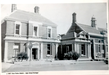 Kew Historical Society Inc
Postcard, Kew Police Station, c.1960
In c.1960, when the photograph was taken on which the postcard is based, both buildings were still owned by the Victorian Government and were a functioning police station and court house. In 1900, ownership of the post office had been transferred to the new Commonwealth Government. In the first decade of the twenty-first century, the police station and court house were offered for sale. They were subsequently purchased and renovated by the City of Boroondara. The Kew Historical Society raised over $5000,000 as a contribution to the restoration.Kew Police Station at left and Kew Court House at right. Monochrome (copied) postcard showing two buildings which are part of a larger complex (once including a post office) built by the Government of Victoria in 1888. The buildings are located at the junction of High Street and Cotham Roads in Kew. The frontages shown face High Street. "c.1960. Kew Police Station. High Street Frontage"kew court house -- high street -- kew (vic.), kew police station -- high street -- kew (vic.), public offices -- kew (vic), queen ann revival -- architectural style -
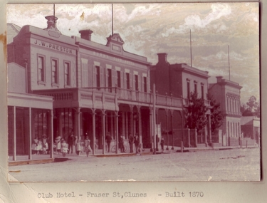 Clunes Museum
Photograph
PHOTOGRAPH OF BUILDINGS IN FRASER STREET CLUNES..1 ORIGINAL SEPIA PHOTOGRAPH MOUNTED ON CARDBOARD OF J.W. PRESTONS CLUB HOTEL, E.S.A BANK AND STATE SAVINGS BANK. ALL TWO STOREY BUILDINGS IN FRASER STREET, CLUNES. .2 BLACK AND WHITE COPY OF ABOVE MOUNTED ON CARDBOARD .3 BLACK AND WHITE COPY OF ABOVE PRINTED ON MATTE PHOTOGRAPHIC PAPERCLUB HOTEL - FRASER ST. CLUNES - BUILT 1870local history, photography, photographs, hotels, club & buildings in fraser street