Showing 123813 items matching "main-road"
-
 Whitehorse Historical Society Inc.
Pamphlet, Artist's Camp, 1987
Pamphlet on Box Hill Artists CampPamphlet on Box Hill Artists Camp and the move to Eaglemont, near Heidelberg when the term Heidelberg School began to be used, in 1988. The Box Hill Camp was made on David Houston's property on Gardiners Creek, south of Canterbury Road, between the present sites of Bowater Scott and Box Hill Golf Club.Pamphlet on Box Hill Artists Camp artists camps, roberts, tom, mccubbin, frederick, streeton, arthur, conder, charles, abrahams, louis, houston, david, gardiners creek -
 Ruyton Girls' School
Photograph - Group photograph, Mrs Charlotte Anderson with younger students, Original image: 1885 circa
In 1878, Mrs Charlotte Anderson founded an private school for girls in her home at Bulleen Road, Kew (now 63 High Street South, Kew). She moved her school to ‘Edgecomb’, in Studley Park Road in 1882 and named it Ruyton. Charlotte Anderson retired in 1888, and sold her school to Miss Eliza Bromby. This image was used to illustrate The Ruytonian, June 1915, p2. The date of manufacture of the duplicate photograph is unknown.Black & white duplicate photograph of Mrs Charlotte Anderson with staff and a group of younger students from Ruyton Girls’ School, c.1885. The group is arranged in three rows of seated and standing individuals, and is located on a garden setting. The photograph was taken at ‘Edgecomb’, Studley Park Road, Kew which was the location of Ruyton from 1882-1888. Mrs Anderson is seated in the middle row, third from right. ruyton girls' school, kew, charlotte anderson -
 Falls Creek Historical Society
Poster - Kangaroo Hoppet 1991
The Kangaroo Hoppet is Australia’s premier long distance cross country ski race, and a member of the Worldloppet series of international cross country ski events. The first race at Falls Creek was held in 1979 under the name of “Australian Birkebeiner”. It was a 21km race with about 80 participants organised by the Birkebeiner Nordic Ski Club of Mount Beauty. The course started and finished at Falls Creek Alpine Resort and took participants out into the Bogong High Plains. After running the event for 10 years, it was decided they should become part of the Worldloppet series of marathon ski races. Representatives from the Birkebeiner Nordic Ski Club and the Australian Ski Federation attended the Worldloppet Annual Meeting in Finland in June 1990 to put the case for the acceptance of an Australian event into the Worldloppet series. Before being admitted, they had to demonstrate that the Birkebeiner Club could run a world class event, so three months later in August 1990 a 42km event named the Australian International Ski Marathon was held at Falls Creek together with a 21km Birkebeiner race and a 7km event called the Birkebeiner Lite. The event was approved by delegates from USA, Norway and Austria, in 1991 Australia became the 12th member of Worldloppet, with the condition that there had to be a name change. After some late night discussion allegedly involving red wine from North East Victoria the main event became the 42km Kangaroo Hoppet, with the minor events being the 21km Australian Birkebeiner, and 7km Joey Hoppet. In the winter of 1991, the first Kangaroo Hoppet was held. It was a great success and has been a regular fixture on the international ski calendar ever since. It features the main 42km event as well as a 21km event and a 7km event. The Hoppet brings the Australian snowfields to an international audience. In 1991 the Men's Winner was John Aalberg from USA in a time of 1:56:12. The winner of the Women's event was Betsy Youngman of USA in a time of 2:16:55.This poster is significant because it documents an event which brings international attention to Falls Creek and the surrounding region.A large coloured poster featuring several images: from top:- Kangaroo symbol: a large group of cross country skiers; sunset over the mountains; mountains in the daytime with a skier on the right and the central image of a skier superimposed over the other images. The logo for Worldloppet is in the centre beneath the main image beside the logo for QANTAS. This was the poster for the first Kangaroo Hoppet held as an international event.Above image: AUSTRALIA' S SKI MARATHON / FALLS CREEK VICTORIA / Kangaroo Hoppet Beneath image: 31 AUGUST 1991 / 42/21/7 km DETAILS FROM RACE SECRETARY BOX 192 MT. BEAUTY 3699 AUSTRALIAkangaroo hoppet, worldloppet events, falls creek, mt. beauty -
 Eltham District Historical Society Inc
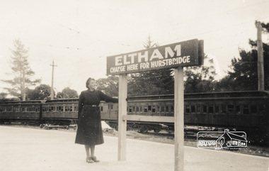
Photograph, Heather Sargeant at Eltham Railway Station
Pages from a scrapbook belonging to Heather Jenkins (nee Sargeant) who lived as a child in the Police Residence at 728 Main Road, Eltham in the 1920s. This photo: Between April 1923 and August 1926, electric trains from Melbourne terminated at Eltham. A connecting steam train ran between Eltham and Hurstbridge. Heather Sargeant was the daughter of Constable W.C. Sargeant, the local police officer in residence at Eltham, 1922-1927Glued on a brown paper scrapbook page (torn from scrapbook) with 8 black and white/sepia photos of varying sizes, 1 newspaper clipping and one greeting card with printed sketch and handwritten captions in ink. On back of page is 1 black and white photo and a large newspaper clipping.eltham, police residence, heather jenkins (nee sargeant), walter withers, constable w.c. sargeant, eltham railway station -
 Eltham District Historical Society Inc
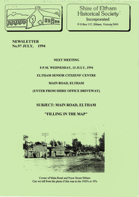
Newsletter, Newsletter, No. 97 July 1994
Contents: • Next meeting, Main Road, Eltham; Filling in the Map • July Meeting • The Shire of Eltham 1871-1994? • The New Eltham Library • The Warrandyte Mystery Tour May 29th 1994 by Bettina Woodburn • Should we do some forward planning on the past for the future? By Harry Gilham • Other News The Shire of Eltham Historical Society was formed in October 1967. The first newsletter of the Society was issued May 1978 and has been published continuously ever since on a bi-monthly basis. With the cessation of the Shire of Eltham in late 1994, the Society's name was revised to Eltham District Historical Society and this name first appeared with issue No. 103, July 1995. The collection of the Society's newsletters provides a valuable resource on the history of the Society's activities, office bearers and committee members, guest speakers and subjects of historical interest pertinent to the former Shire of Eltham and the Eltham District.A4 photocopied newsletter distributed to membersnewsletter, eltham district historical society, shire of eltham historical society -
 Eltham District Historical Society Inc
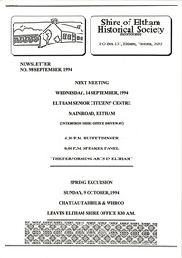
Newsletter, Newsletter, No. 98 September 1994
Contents: • Next meeting, Main Road, Eltham; Filling in the Map • July Meeting • The Shire of Eltham 1871-1994? • The New Eltham Library • The Warrandyte Mystery Tour May 29th 1994 by Bettina Woodburn • Should we do some forward planning on the past for the future? By Harry Gilham • Other News The Shire of Eltham Historical Society was formed in October 1967. The first newsletter of the Society was issued May 1978 and has been published continuously ever since on a bi-monthly basis. With the cessation of the Shire of Eltham in late 1994, the Society's name was revised to Eltham District Historical Society and this name first appeared with issue No. 103, July 1995. The collection of the Society's newsletters provides a valuable resource on the history of the Society's activities, office bearers and committee members, guest speakers and subjects of historical interest pertinent to the former Shire of Eltham and the Eltham District.A4 photocopied newsletter distributed to membersnewsletter, eltham district historical society, shire of eltham historical society -
 Sacred Heart College
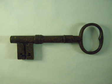
Gate Key, 1870s
This key was to the Sacred Heart Convent gates which were originally located off Skene Street. At the time, Skene Street was considered the main entrance to Geelong from the West. The Convent entrance was built to face this major though fare. The gates were later moved to an entrance at the southern end of Retreat Road. The original key to the Sacred Heart Convent. Metal key, rusted and worn.sacred heart convent, newtown, geelong, sisters of mercy, convent, orphanage, key, 1870s, sacred heart, shc -
 Eltham District Historical Society Inc
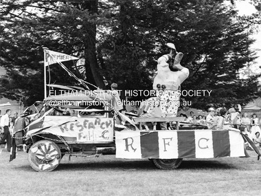
Photograph, Research Football Club float, Ersilac Parade, Easter Show, Eltham c.1959, 1960
Celebrating Research Football Club's 1959 Premiership. From the mid-1950s the Eltham Horse and Pony Club held the Eltham Easter Fair at Eltham Park (now Eltham Lower Park). In the late 1950s the fair was named ERSILAC and included a procession along Main Road from the town centre to the park.Black and white photographersilac, fairs, festivals, floats, football, eltham, easter, research (vic.), research football club -
 Kew Historical Society Inc
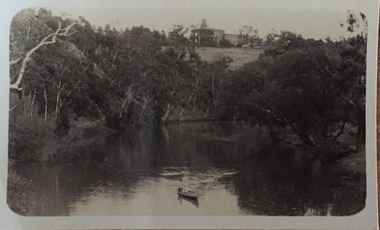
Photograph - Zig-zag Bridge on the Yarra River at Kew, Henry Beater Christian, 1920-28
Henry Christian (c.1809-91), the grandfather of the photographer, was one of the first settlers in Kew. He arrived in Victoria with his wife Agnes and son Orlando in 1855 on the Gypsy Queen. He established a rope-making business in Bulleen Road by 1858 but was declared insolvent two years later. In his final years, he was celebrated as one of the oldest living settlers of the district. His son, Orlando Henry Beater Christian (c.1853-1930) became a member of the Hawthorn Band and a foundation member of the Willsmere Swimming Club. Orlando and his wife Elizabeth had four children of which Henry Beater Christian (1886-1962) was the eldest.Small black and white photograph of the Yarra River at Studley Park. In the middle ground, a man is paddling a canoe upstream. On the horizon, the tower and buildings of Raheen in Studley Park Road can be seen.henry christian (1886-1962), landscape photography, kew canoe club history — — photographs, yarra river -- studley park -- kew (vic.), christian-washfold collection -
 Kew Historical Society Inc
Plan - Subdivision Plan, Camberwell Mountain View Estate, 1923
The Kew Historical Society collection includes almost 100 subdivision plans pertaining to suburbs of the City of Melbourne. Most of these are of Kew, Kew East or Studley Park, although a smaller number are plans of Camberwell, Deepdene, Balwyn and Hawthorn. It is believed that the majority of the plans were gifted to the Society by persons connected with the real estate firm - J. R. Mathers and McMillan, 136 Cotham Road, Kew. The Plans in the collection are rarely in pristine form, being working plans on which the agent would write notes and record lots sold and the prices of these. The subdivision plans are historically significant examples of the growth of urban Melbourne from the beginning of the 20th Century up until the 1980s. A number of the plans are double-sided and often include a photograph on the reverse. A number of the latter are by noted photographers such as J.E. Barnes.The so-called Camberwell Mountain View Estate was a subdivision on ‘the corner [of] Burke Road, Eyre and Wills Streets, Deepdene’. The Estate was not the first attempt to subdivide this land holding. In 1884, 1888 and 1894 the Belmore Park subdivision proposed 18 allotments for this parcel of land. The final stages of the Belmore Park subdivision occurred during the Depression of the 1890s. Apart from perhaps one block facing Burke Road, which is unnumbered in the Mountain View Estate subdivision, the rest must have remained unsold. The later subdivision would redraw the original 18 allotments, creating 22 new lots. In the Locality Plan on the left side of the subdivision plan, Deepdene Station, which formed part of the Outer Circle Railway is represented, as is the location of Deepdene Primary School. A selling point was the proposed extension of the Burke Road tram beyond its terminus at Cotham Road. The extension did not eventuate.subdivision plans - camberwell, mountain view estate -
 Bendigo Military Museum
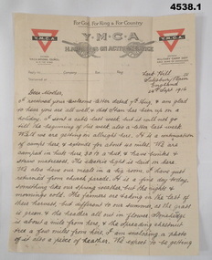
Letter - LETTER AND ENVELOPE 1916, C. 1916
Letters written by Alfred G Ferris No 2156 AIF from Training camps in England. refer cat No 4183.3P for his service details..1) letter, “ “YMCA, H.M.Forces On Active Service” letterhead, print in red and black, ruled lines, hand written in black pen, dated. .2) Envelope, yellowish colour, green postage stamp, hand writing in black pen. .3) .4) letter, same as .1) different date and Camp..1) Main points, “Lark Hill Salisbury Plain England, 24th sept 1916”, “Dear Mother”. .2) addressed, “Mrs A.E.Ferris Terrick Terrick Via Pyramid” .3) Main points, “Hurdcott camp 23 Nov 1916”, “Dear Mother & ones at home”.letters, ymca, envelopes, ww1 -
 Surrey Hills Historical Society Collection
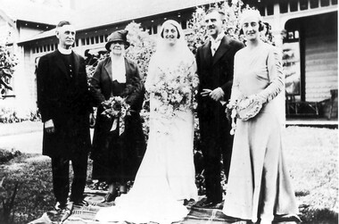
Photograph, Wedding photo of Minnie Beckett with her parents, 1934
Wendy McLellan is the daughter of Minnie Caroline Beckett (1907-1998). Minnie married Francis James Renkin on 13 March 1934. Peter Renkin (formerly of 59 Guildford Road, Surrey Hills, now Shoreham) is her brother.Black and white wedding photo taken of Minnie Beckett with her parents, Rev Walter and Mrs Clara Beckett, her brother Kenneth and her sister Maude, the bridesmaid. The family group is standing on a picnic rug in front of an Edwardian style timber home with simple verandah fretwork. The house is 'Deloraine', 268 Union Road, Balwyn.weddings, balwyn, union road, miss minnie beckett, rev walter beckett, mrs clara beckett, kenneth beckett, miss maude beckett, 'deloraine', 1930-1940 -
 Whitehorse Historical Society Inc.
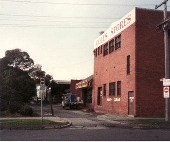
Photograph, Enterprise Way, 13/06/1986 12:00:00 AM
2 Coloured photos of Enterprise Way - Right-of-way B/N Brittania Street and Mitcham Road. This lane ran between the rear of shops on Whitehorse Road and the Mitcham Primary School (Lower School). Demolition of the school made way for Coles/New World Supermarket and several shops on Whitehorse Road made way for Original Coles Variety Store (facing Whitehorse Road) in foreground.coles variety store -
 Ringwood and District Historical Society
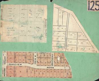
Card, Collage of Residential Subdivision Map Clippings - Ringwood, Victoria - (Undated)
Three maps mounted on green cardboard - Hand-drawn map of residential allotments off Warrandyte Road in Milne Road and Berringa Road Park Orchards. Map with acres roods and perches measurements of allotments in Canterbury Road and Miller Street Heathmont. Clipping from a land sale brochure with street names not existing together in the area - Rangeview Avenue, Press Avenue and Mountview Avenue. -
 Southern Sherbrooke Historical Society Inc.
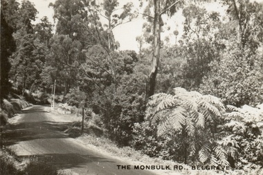
Postcard, The Monbulk Rd, Belgrave
Sepia-toned postcard showing Monbulk Rd, Belgrave, presumably heading towards Kallista. Road is unmade. Trees and ferns growing along side of the road. The ground slopes downhill from left to right. At a bend in the road a stretch of wooden barrier is visible near a gully. -
 Kew Historical Society Inc
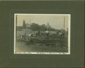
Photograph - Electric tram line construction on the corner of Cotham & Glenferrie Roads, Kew, E.J. Dower, 1913
One of a series of photographs, taken by Edgar James Dower in the second decade of the twentieth century. Born and raised in Olinda, his family later moved to Surrey Hills. He worked as an adult as a clerk in the city office of the Metropolitan Gas Company, and in his role as a 'collector', he was able to photograph scenes including the construction of tramlines and associated buildings in Kew, Hawthorn, Camberwell and Surrey Hills. Later he established a real estate agency with his brother - the E.J. Dower Real Estate Agency, Dandenong Office.The image is an historically significant record of the development of transport infrastructure which was used to connect Victorians in the first two decades of the twentieth century. This development resulted from increases in population and the consequent extension of Melbourne's suburbs. The photographs, both individually and collectively, richly detail the labour of workers and the tools and machinery used to create and extend Melbourne's tram network in the years preceding and during World War 1.Digital copy of an original mounted photograph depicting construction of a new electric tramline taken near the corner of Cotham and Glenferrie Roads, Kew. In 1913, trams could turn left or right into Cotham Road from Glenferrie Road. The photo shows workers constructing the tracks.Annotated recto: "Construction of Electric Tram Line / car Cotham & Glenferrie Ads Kew / 1913". . Annotated verso: "Taken by E.J. Dower 1913"theme --- travelling by tram, theme -- connecting victorians by transport and communications, cotham road -- kew (vic.), trams -- kew (vic.), glenferrie road -- kew (vic.) -
 Surrey Hills Historical Society Collection
Work on paper - Vertical file, Armitstead family
The Armitstead family's first woodyard in Surrey Hills was located in Croydon Road but later they moved to 153-157 Union Road, Surrey Hills. The business delivered timber and briquettes for heating to homes in the local area but also blocks of ice in the days before refrigerators were a usual household appliance. The timber was unloaded from railway trucks at a siding at Surrey Hills station; some came from the Armitstead's property of 130 acres of timbered land near Killara. They also sold mallee roots and briquettes.A vertical file containing the following documents: 1. Land Victoria map of Surrey Hills including Union Road from Bedford Street to Montrose Street, showing location of woodyard (undated) (1 A3 page). 2. Possibly ‘Sun’ article ‘When Surrey Hills ran short of wood’, Michael Sefton (undated) (1 page). 3. Plaque for the red mechanism of the weighbridge at Centre, by convenor, Surrey Hills Heritage Group, 12.11.2002 (1 page). 4. Pooley and Sons weighbridge, notes by Dennis Armstrong, in email to Sue Barnett, 4.4.2013 (2 pages). 5. Laminated diagram and notes by Ken Hall re weighbridge from Armitstead’s woodyard, and photocopy, undated (3 pages). 6. ‘Armitstead’s woodyard’ 153-7 Union Road (now Neighbourhood Centre), typed Progress Leader article, 13.1.1982 (2 pages). pooley and sons weighbridge, armitstead family, woodyard, armitstead's woodyard, union road -
 Ringwood and District Historical Society
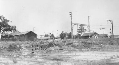
Photograph, Ringwood Coolstore site after clearing in 1963, 1963
Black and white photographWritten on back of photograph: "Site of Cool Store- 17.11.63. Old goods shed to the left, new shed to the right. Kendall's house (old hospital) in background. Corner of Whitehorse Road and Watirna Road. Photographed by Brian Pump, 36 Knaith Road, Ringwood East. -
 Federation University Historical Collection
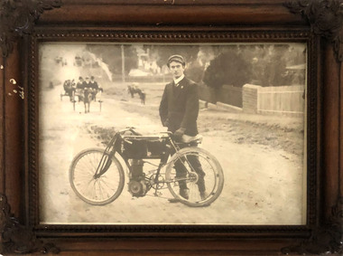
Photograph, Photograph of A.E. Sutton with motorcycle
Henry Sutton is a talented world-wide accepted inventor with inventions relating to the telephone, photography, wireless, cars, motorcycles, and bicycles as well as many more inventions. Henry was also one of four brothers that ran the Sutton's Music Store after the death of their Father Richard Sutton. Henry Sutton taught Applied Electricity at the Ballarat School of Mines in 1883 to 1886.Black and White Photograph of A.E. Sutton and motorcycle on which he won the first VMCC 100 Mile road road race in 1906, in a brown wooden framed.henry sutton, a.e. sutton, motorcycle, photograph, vmcc, race, winner -
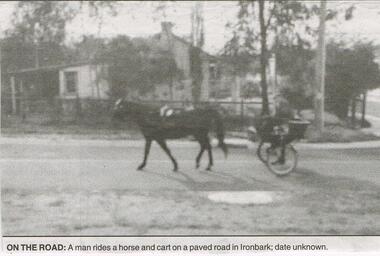 Bendigo Historical Society Inc.
Newspaper - JENNY FOLEY COLLECTION: ON THE ROAD
Bendigo Advertiser "The way we were" from Friday, October 17, 2003. On the road: a man rides a horse and cart on a paved road in Ironbark, date unknown.newspaper, bendigo advertiser, the way we were -
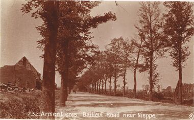 Bendigo Historical Society Inc.
Postcard - ACC LOCK COLLECTION: ARMENTIERES BAILLEUL ROAD NEAR NIEPPE, POSTCARD, 1914-1918
Postcard, WW1, Sepia image of the Armentieres Bailleul road near Nieppe. Road is treelined with a ruined building on the left. Figure and horse and cart in the distance. Copy Z32postcard, postcard, ww1, armentieres, bailleul, nieppe, france -
Whitehorse Historical Society Inc.
Newspaper - Advertisement, Bellevue Hill, 1971
Newspaper cutting advertising sale of Bellevue Hill Estate, East Burwood in 1971. Comprising 113 home sites. Estate bordered by Mahoneys Road and Springvale Roadland subdivision, land sales, development underwriting pty. ltd., mahoneys road, burwood east, springvale road, the sun property guide -
Whitehorse Historical Society Inc.
Letter - Correspondence, Acquisition by Country Roads Board, 10/04/1956 12:00:00 AM
Letter from Country Roads Board to Mrs K.A. Tenny advising erection of new fence for KindergartenLetter from Mrs K.A. Tenny to Country Roads Board informing Board old fence replaced on Kindergarten Holiday Home, Canterbury Road, Forest Hill.Letter from Country Roads Board to Mrs K.A. Tenny advising erection of new fence for Kindergartenpreschools, forest hill residential kindergarten, victoria. country roads board, tenny, k.a. (mrs) -
 Whitehorse Historical Society Inc.
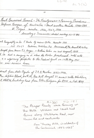
Map, Frank Ainger, 1873
Application by Frank Ainger for land in the Parish of Nunawading on Whitehorse Road near Mitcham Road. Also included are several references from other sources to Frank Ainger.ainger, frank, shire of nunawading, mitcham, land settlement -
 Whitehorse Historical Society Inc.
Photograph, Vermont Primary School
Black/white - Vermont Primary School located on corner of Canterbury and Mitcham Roads, Vermont. Buildings moved in 1980's to Primary School in Nurlendi Road, Vermontvermont primary school no. 1022, nurlendi road, vermont, canterbury road, mitcham road, armstrong, ian -
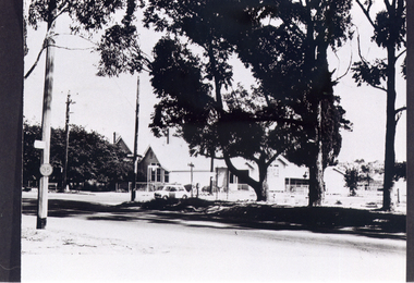
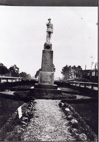 Whitehorse Historical Society Inc.
Photograph, Mitcham War Memorial
Black/white of Mitcham War Memorial taken inside fence when Memorial was located in Whitehorse Road, Mitcham. Since relocated to Halliday Park in Mitcham Roadwar memorial mitcham, armstrong, ian -
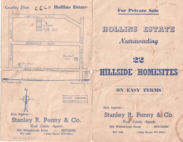 Whitehorse Historical Society Inc.
Document, Hollins Estate, 1955
Private sale of 22 hillside home-sites on Junction Road, Blackburn, called Hollins Estate by Stanley R. Penny & Co., 524 Whitehorse Road, Mitcham.hollins estate, stanley r. penny & co., real estate agents, blackburn, junction road, suto, joyce -
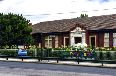 Whitehorse Historical Society Inc.
Photograph, Mitcham State School No 2904, 2012
See NP3945Coloured photograph of the Mitcham State School situated on the west side of Mitcham Road, opposite East Doncaster Road. Sign on the fence requesting 2012 prep enrolments.mitcham state school no 2904, state schools -
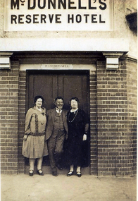 Whitehorse Historical Society Inc.
Photograph, McDonnell's Reserve Hotel, c1920
Black and white photograph of the front of the McDonnell Reserve Hotel, corner Mitcham Road and Whitehorse Road Mitcham c 1920. Man and women not known Original on CDROMreserve hotel, mitcham, mcdonnell, whitehorse road, mitcham road -
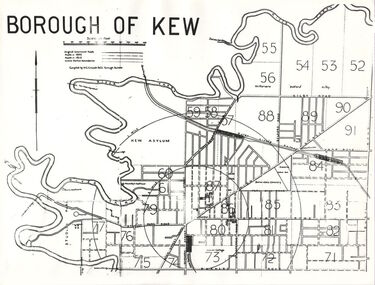 Kew Historical Society Inc
Plan, Borough of Kew, 1910
This work forms part of the collection assembled by the historian Dorothy Rogers, that was donated to the Kew Historical Society by her son John Rogers in 2015. The manuscripts, photographs, maps, and documents were sourced by her from both family and local collections or produced as references for her print publications. Many were directly used by Rogers in writing ‘Lovely Old Homes of Kew’ (1961) and 'A History of Kew' (1973), or the numerous articles on local history that she produced for suburban newspapers. Most of the photographs in the collection include detailed annotations in her hand. The overhead transparency is of a map produced by H.C. Crouch Borough Surveyor in 1910The Rogers Collection provides a comprehensive insight into the working habits of a historian in the 1960s and 1970s. Together it forms the largest privately-donated collection within the archives of the Kew Historical Society.An overhead transparency of a plan of Kew comparing the roads in 1860 with later roads constructed by 1910. Sections of the plan are marked with the location of particular buildings, farms or transport routes.Borough of Kewborough of kew, h.c. crouch