Showing 2474 items matching " township"
-
 Lakes Entrance Historical Society
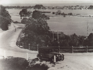
Photograph - Princes Highway around Jemmys Point, Lakes Entrance, H D Bulmer, 1930 c
Princes Highway around Jemmys Point, car parked on road at junction of original steep road to top of Jemmys Point. Man on bicycle riding up hill. Bullock Island and New Works in distance over North Arm and Cunninghame Arm waterways Lakes Entrance VictoriaBlack and white photograph of lower section of Princes Highway around Jemmys Point, car parked on road at junction of original steep road to top of Jemmys Point. Man on bicycle riding up hill. Bullock Island and New Works in distance over North Arm and Cunninghame Arm waterways Lakes Entrance Victoriaroads and streets, township, waterways, fences, vehicles -
 Lakes Entrance Historical Society
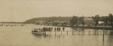
Photograph, Tourist Launch, Lakes Entrance - Easter 1928, Easter 1928
They are about to board a tourist launch in front lake. Buildings shown on Esplanade from Federal Hotel to Glenara Lakes Entrance Victoria. Faded black and white photograph showing about two dozen people on jetty . Also a black and white copy township, waterways, tourism, boats and boating, jetties -
 Kiewa Valley Historical Society
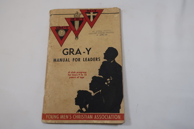
Book - Manual, GRA-Y Manual for Leaders
With the creation of the township of Mount Beauty in 1946 the SECV made every effort to provide wholesome activities for the 3000+ people suddenly living in the remote new community. GRA-Y was an American system of Gymnastics for men and boys under the umbrella of the YMCA. The Gra-Y club continued on to the 1980s.This book is the manual used to train leaders and was used continually through the years. This copy was the property of Mr Ron White, who went on to become Engineer in Chief-Hydro.Cream coloured with black and red decals and writing on soft card cover. 142 pages held by two staples. Three red logos on top left hand side.Sub titles: 'A club program / for boys 9 to 12 / years of age' and along the bottom 'Young Men's Christian Association'Front and back stamp: The National Committee / Young Men's Christian Association / of Australiagra-y, ymca, gymnastics, boxing, wrestling, boys' club -
 Bendigo Historical Society Inc.
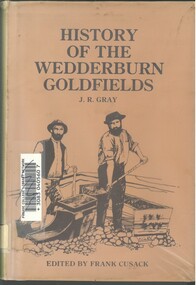
Book - HISTORY OF THE WEDDERBURN GOLDFIELDS, 1888
Gold was first discovered in 1852 on what was then named Korong or Mt Korong goldfields. It was soon found that the area was not suitable for alluvial mining because of a lack of water but quartz mining was more successful. The township of Wedderburn was surveyed 1856/57. The first public crushing works was established in 1859.Hardcover book with printed dust jacket and plastic cover. 92 pages with black and white illustrations, fold out map and index. Covers the history of the Wedderburn Goldfields and the discovery of gold generally in Australia from the 1850s until c1880s. Written by Joshua R Gray and edited by Frank Cusack.Joshua R Gray and Frank Cusack.gold, goldfields, goldfield -
 Kiewa Valley Historical Society
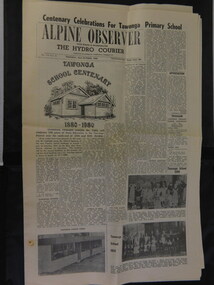
Alpine Observer Newspaper - 23 Oct. 1980 x2, 23 Oct. 1980
The Tawonga Primary School celebrated its centenary with a program including a fete, sports, family dance and combined church service over the weekend of the 25th - 26th Oct. 1980. The newspaper covers the Alpine Shire and included further articles that would interest visitors to the centenary.Tawonga School was one of the earliest schools in the Kiewa Valley supplying an education for the children of the local farming community. The Bogong Hotel at Tawonga, the Tawonga Butter Factory and the town of Mt Beauty articles were printed providing up to date historical information on prime locations nearby. Of interest as the Hotel has burnt down and the Butter factory no longer exists. Alpine Observer newspaper dated Thursday, 23 rd October 1980 with a sketch of the school and articles regarding the Centenary of the Tawonga School on the front page. (The paper consists of 12 pages ie. 6 sheets) 2 copies On page 4 is an article on the history of the Bogong Hotel at Tawonga On page 5 is an article on the history of the Tawonga Butter Factory and an article on the township of Mt Beauty.newspaper articles; tawonga primary school; bogong hotel; tawonga butter factory -
 Wycheproof & District Historical Society Inc.
Bunguluke Map, Bunguluke District In 1923, 27.2.1923
By 1881 Bunguluke was a small settlement as recorded, December 5, in the Charlton "Mercury". It reports that in that year Draper's Store, Hotel and Post Office and residence at Bunguluke North was totally destroyed by fire. For years now there has been little sign of community life with houses few and far between and acreages have gone into larger holdings. The map references land blocks and owners for that era.This important map shows the local land ownership and local features that existed in 1923. This is a photocopied black and white map of Bunguluke in the County of Kara Kara, Number L5149. Marked - Photo Lithographed by W.J. Butson 27.2.1923. The details include numbers of allotments, property owners, roads, rivers. The boundaries marked are the Parish of Jeruk, Parish of Wycheproof, Parish of Cooroopajerrup. Wycheproof township location is shown with the Scale of Chains. Bunguluke maps for other years are also in the collection.map, bunguluke, jeruk, wycheproof, cooroopajerrup -
 Warrnambool and District Historical Society Inc.
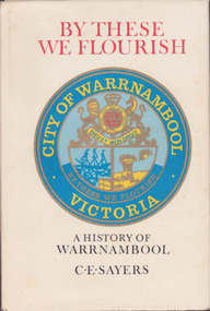
Book, C. E. Sayers, By These We Flourish A History of Warrnambool, 1969
History of Warrnambool to 1969This is a hard cover book with a sepia photograph on the cover and a cream-coloured dust cover with a colour image of the City of Warrnambool logo. Endpapers have a black and white 1840s sketch of a Plan of Township and Warrnambool Bay. There are 21 chapters and 16 pages of black and white photographs. There is a Foreword by Harold Stephenson, an introduction by the author, a Table of Contents, an Index, Appendices and lists of Warrnambool Councillors. non-fictionHistory of Warrnambool to 1969history of warrnambool book, ‘by these we flourish’, c e sayers, warrnambool -
 Ringwood and District Historical Society
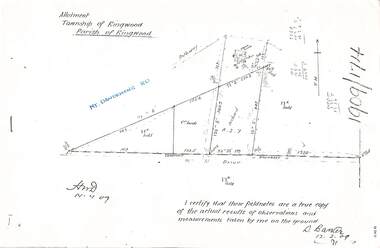
Document - Copy of Lands Department Field Notes - Parish of Ringwood, Victoria, Field Notes 1909/174 - Part of O.P. R72D surveyed 12.3.1909
Foolscap size photocopy of survey map with handwritten notations. References include Mount Dandenong Road, pathway, 2 room house, scillion, shed, WC, 17C sold, Cr lands, orchard, 17E sold, Township boundary, I certify that these field notes are a true copy of the actual results of observations and measurements taken by me on the ground (signed) D. Barker 12.3.09. -
 Bendigo Historical Society Inc.
Map - MARONG : COUNTY OF BENDIGO, June 1953
Map> Marong, County of Bendigo, Nerring, Sandhurst, Lockwood, Shelbourne, Woodstock, Leichardt, Bullock Creek, Fletcher Creek, Township of Marong, Bendigo Railway Line, Marong Railway Station, Crusoe Aqueduct. Drawn and reproduced at the Dept. of Lands and Survey, Melbourne, Victoria. June 1953. Price 2/-. By authority W.M. Houston, Government Printer. (number 74 in map cupboard 1)W.M. Houston, Government Printer.map, bendigo, marong -
Bendigo Historical Society Inc.
Map - ELLESMERE : COUNTY OF BENDIGO, 18-1-1943
Map. Ellesmere, County Bendigo, Bagshot, Wellsford, Axedale, Muskerry, Goornong, Bendigo Creek, Bendigo to Echuca- Northern Railway Line, Campaspe River, Sugarloaf Trig.Station. Township of Fosterville.By Authority: H.E. Daw, Govt. Printer, Melbourne. Drawn ad reproduced at the Dept. of Lands and Survey, Melbourne . 18-1-1943.Price 2/-. (number 37 in map cupboard 1)H.E. Daw, Government Printer, Melbourne.map, bendigo, ellesmere -
Bendigo Historical Society Inc.
Booklet - Up the Creek and Back Again, 2014
BHS CollectionSoft cover booklet of 96 pages titled 'Up the Creek and Back Again'. The remarkable story of Carisbrook's 2011 floods and recovery. Edited by Carlene Dowie. Aerial photo of flooded township on front and back covers. Illustrated with colour photos of people and events. First published by Carisbrook Disaster Recovery Committee Inc 2014. Printed by McPherson Printing Group, Maryborough, Victoria'M&J Qualtrough' sticker on first page carisbrook, floods -
 Bendigo Historical Society Inc.
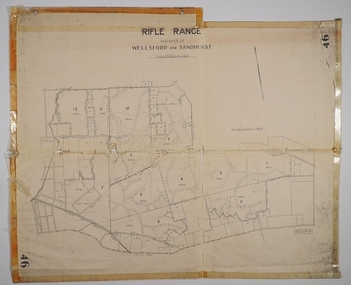
Map - CAMPBELL COLLECTION: BENDIGO AND DISTRICT MAPS
Map. Rifle Range, Parishes of Wellsford and Sandhurst. Scale 20 chains to 1 inch. Total area in plan is 5916 acres. Wallan and Bendigo Railway to Axedale Township and station 8 miles, to Longlea Railway Station 2 1/2 - 3 miles. Rifle Range. Compiled in W.P.B. from Assessment and Parish Plans, by H.A.D. 8-7-29H.A.D.(Darby).map, bendigo, allotments, bendigo rifle range, sandhurst parish, wellsford parish -
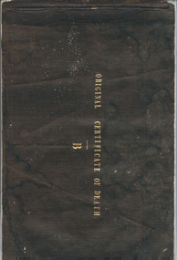 Warrnambool and District Historical Society Inc.
Booklet, Original Certificate of death 1853-1854, Mid 19th century
These certificates of death are original and give details of 47 deaths from July 1853 to February 1855 with the deaths mostly from the Villiers district in the Parish or Township of Warrnambool. The deaths have been registered by John Martin Ardlie and the doctors’ signatures include those of Isaac Corney and Berkeley Hutchinson. This booklet is of high significance as many of the deaths recorded herein are not registered anywhere else and some were buried in the Warrnambool Cemetery before official records began. The Warrnambool Cemetery was gazetted in June 1854. The certificates were found in a private house in Warrnambool.This is a bound booklet with a black linen cover and containing 40 pages. The pages are designed to have the information written twice with one section called the Counterpart and the second called the Original Certificate of Death (Schedule B). The counterpart section was meant to be kept in the booklet and the second section was to be cut out and sent or put elsewhere. The first seven pages have the one Counterpart section and the rest are complete with the two sections. The pages are blue with printed headings for the Registrar of Deaths to fill in. The information on 12 of the pages are incomplete and the entries are handwritten in ink. Front cover: Original Certificate of Death, Bwarrnambool cemetery, early warrnambool death records 1853-1854, john martin ardlie, warrnambool history, isaac corney, berkeley hutchinson -
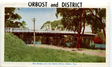 Orbost & District Historical Society
postcard series, 1960s
Included are photographs of the Orbost township, the Snowy River at Marlo, Gypsy Point, Buchan Caves and Bairnsdale. In the 1960s Orbost had a population of 4000 and was a major tourist attraction in Eastern Victoria with sufficient accommodation and facilities. It was the major town close to several national parks with access to either the surf or the snow. These postcards are pictorial records of Orbost in the 1960s. Postcards are very interesting records of places. architecture and transport.A colour postcard series with photographs of Orbost and the district. The cover photograph is of the Snowy River Bridge. There is an information card.Each photograph is labelled. at the bottom.postcards-orbost postcards-east-gippsland -
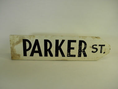 Torquay and District Historical Society
Sign - Street Signs, James and Ray Baines, Circa 1938
James Baines was principal of Torquay primary school, a local historian and genealogist and authority on Australian plants. He and his wife Ray were responsible for the manufacture and erection of street signs in the fledgling township of Torquay circa 1937. The signs were later removed by the Council and replaced by "official" signage.A great example of local initiative and community involvement.A collection of wooden hand painted street signs. Beales St. Cliff St. Cowrie Rd. Darrien Rd. Fischer St. Grandview Rd. Henty St. New St. Park La. Price St. Short St. Voss Rd. Walker St. Zeally Bay Rd.torquay victoria, baines, early street signs -
 Bacchus Marsh & District Historical Society
Map, Lerderderg Park Lands sale plan. 1911
This plan was for the sale of parcels of land from the Lerderderg Park Estate property in 1911. Advertising for the sale appeared in the Bacchus Marsh Express newspaper through July of 1911. The property was situated only a few kilometers from the township of Bacchus Marsh. The agents for the sale were L. A. Fairbairn & Co.Lerderderg Park Estate was a significant and early colonial property in the Bacchus Marsh area. This plan provides details about the first time the property was subdivided for sale. It is therefore documents an important moment in the history of this property and the broader trend of the subdivision of older and larger properties in the district.A single page paper plan showing allotments of land for sale from the Lerderderg Park property owned by John Wills. The parcels of land for sale are coloured in red.The Lerderderg River and Pyke's Creek Irigation Channel shown on the plan are in blue ink. The rest of the plan is a dark cream or beige colur with the text in black ink. The plan has been extensively annotated with hand-written notes indicating the names of people who purchased the various parcels of lands and the prices paid for those lands. Part of the top of the plan containing some text appears to be missing. The plan is pasted into a bound volume containing 76 maps or plans in total. Top: Have received instructions to Sell, account Mr John Wills, his renowned LERDERDERG PARK LANDS, so well and favourably known throughout the Commonwealth. In areas from 3 acres to 1276 acres. Every lot is either rich lucerne land (or portion now under lucerne) with some higher land adjoining Railway Station, and 2 Milk factories within 2 miles, absolutely the finest land in Victoria. Bottom: THIS IS THE FIRST SUBDIVISIONAL SALE of Rich Flats in Bacchus Marsh since the Pyke's Creek Scheme, and every lot is commanded by it. Only 32 miles from Melbourne.bacchus marsh victoria maps, land sales, lerderderg park estate, land subdivision -
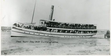 Lakes Entrance Historical Society
Photograph - S.S. Gippsland, 1909
Also one enlarged copy 18.5 x 27.5 cm, one other copy set on white card 12 x 20 cm, but row boat erased, part of background visible showing part of township of Lakes Entrance (Cunninghame) and part of New Works wharf on right.Black and white photograph showing S S Gippsland leaving New Works wharf. Small rowing boat on right on beach. Hull painted white. Lakes Entrance VictoriaNew Year Trip 1909 Cunninghame A Cooper Photojetties, waterways, ships and shipping -
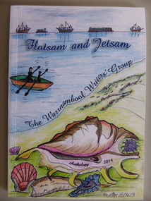 Warrnambool and District Historical Society Inc.
Book, Flotsam and Jetsam, 2014
This is an anthology of writings by members of the Warrnambool Writers’ Group. The group was formed nearly 30 years ago and has published several other anthologies. The book contains writings from current members of the group and many contributions contain reference to Warrnambool’s maritime and township history and present day affairs. The book is of some significance as the contents are by local people and refer not only to their personal thoughts and ideas but also to aspects of Warrnambool’s past and current situation. It has, therefore, social and cultural significance. This is a paper-back book of 85 pages. The cover is multi-coloured with a seascape design on the front cover and printed material on the back cover. The inside pages contain printed material only with a sketch of a boat on the frontispiece. The pages have been bound with glue. Front Cover: ‘Flotsam and Jetsam’, The Warrnambool Writers’ Group, Anthology 2014, © SM 160413’warrnambool, poetry and short stories -
![Photograph - Digital image, Log bridge to Willis Vale [1], 16/10/1903c](/media/collectors/4f729f5697f83e03086015b8/items/54435d6d2162f10ea4a205f1/item-media/54435d962162f10ea4a20821/item-fit-380x285.jpg) Greensborough Historical Society
Greensborough Historical SocietyPhotograph - Digital image, Log bridge to Willis Vale [1], 16/10/1903c
Photograph shows visitors crossing the river to "Willis Vale" homestead, home of the Partington family. For many years this log bridge was the quickest way of reaching the Greensborough township from Willis Vale. [Thought to have been taken on or about 16/10/1903 during the funeral week of Ellen Partington.]Digital copy of black and white photograph.willis vale, partington family, plenty river -
![Photograph - Digital image, Log bridge to Willis Vale [2], 16/10/1903c](/media/collectors/4f729f5697f83e03086015b8/items/544360612162f10ea4a21abb/item-media/544360862162f10ea4a21c93/item-fit-380x285.jpg) Greensborough Historical Society
Greensborough Historical SocietyPhotograph - Digital image, Log bridge to Willis Vale [2], 16/10/1903c
Photograph shows visitors crossing the river to "Willis Vale" homestead, home of the Partington family. For many years this log bridge was the quickest way of reaching the Greensborough township from Willis Vale. [Thought to have been taken on or about 16/10/1903 during the funeral week of Ellen Partington.]Digital copy of black and white photograph.willis vale, partington family, plenty river -
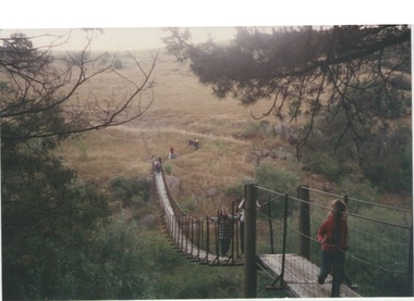 Sunbury Family History and Heritage Society Inc.
Photograph, Catanery Bridge, Bulla, c1980s
The narrow swing catanery bridge was built behind the school across the Deep Creek downstream from the bluestone Bulla Bridge. It was built so that children who lived on the south side of Bulla Township could access the school more easily and in shorter time than if they had to go by the main roads.The bridge was constructed in the days when most children walked to school. The use of this bridge cut the children's travel time and distance to school quite considerably and was used for many years until the school was closed in 1996.A coloured photograph of the children on a narrow swing bridge and the path they used to approach the bridge over open ground. bulla primary school, swing bridge, bridges, catanery bridge -
 Bacchus Marsh & District Historical Society
Financial record, Weekly Account Book of William Grant's Bakery Business in Melbourne circa 1840s
William Grant was an early European colonist in the Bacchus Marsh township. Before arriving in Bacchus Marsh he conducted a bakery business in Melbourne in the 1840s. He arrived in Bacchus Marsh around 1850 and became successful in business and was prominent in many community and local government organisations. He died in 1884. Bound ledger book with hand written entries listing products and services provided by a bakery business conducted by William Grant in Melbourne. The entries cover the period 1842-1843.william grant 1813-1884, grant family bacchus marsh -
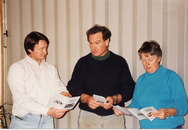 Sunbury Family History and Heritage Society Inc.
Photograph, 21st August 1994
The three people from L-R: Graham Gibb, Trevor Dunn and Wendy Sutherland were members of the Sunbury & District Heritage Association and were attending the launch of a booklet that the Association produced. It was a publication launched on the 21st Au8gust 1994, that highlighted four historic walks around the the old Sunbury township. The walks booklet was the first of a number of publications that the Association produced over the years, highlighting Sunbury's history.A non-digital coloured photograph of a lady and two men discussing a pamphlet.graham gibb, trevor dunn, wendy sutherland, sunbury walks, sunbury & district heritage association -
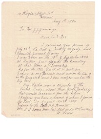 Linton and District Historical Society Inc
Letter, To J. Jennings from W. Todd, 1934
Handwritten letter to Mr. Jennings clarifying birth date information. Letter written by Mr. W. Todd. Letter dated 1st. August, 1934.Text: " 10 Raglan Street Nth. / Ballarat / Aug. 1st, 1934 / To J.J.J. Jennings / Dear Sir / I received your memo of / July 26th Re date of Birth of myself and / herewith furnish same. / I was born on the 13th of September 1855 / at Linton just opposite the Cemetery / at the time a township. "william todd, j. jennings, correspondence, letters, date of birth -
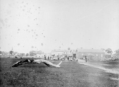
 Stawell Historical Society Inc
Photograph, Great Western 1866
Great Western. Part of a collection of Photographs by Mr. O.G. Armstrong as commissioned by the Shire of Stawell for the Inter-colonial and Paris Exhibition in Melbourne in 1866. Great Western began as a changing station on Concongella, northeast of the present Township. The gold rush in Great Western began in 1858 and soon after a post office and store opened. A Township was surveyed and lots sold in October 1858. The gold soon passed and the diggers went on, leaving a small settlement. In 1863 Jean Pierre Trouette and Emile Bampied, his brother-in-law, planted the first vines and build the first winery, thus setting a firm foundation upon which the present wine industry has been built. Telegraph poles and wires visible. Bakery visible in distance on right of road, looking west. stawell -
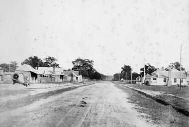
 Stawell Historical Society Inc
Photograph, Glenorchy 1866
Glenorchy. Part of a collection of Photographs by Mr. O.G. Armstrong as commissioned by the Shire of Stawell for the Inter-colonial and Paris Exhibition in Melbourne in 1866. Glenorchy township began as a resting place for bullock teams and travellers in the 1840s. In 1847, John Gleeson built the Four Posts Inn, which then became the name of the settlement. Gleeson is credited with naming the settlement Glenorchy, meaning tumbling waters, after his birth place in Scotland. In 1865 the Township consisted of a church, school, three hotels the Four Post Inn built 1847, Royal Hotel built 1855, The Royal Mail Hotel built1862. As well as boot makers, a blacksmith, stores, butcher and other enterprises. The town was a postal centre served by three coaches each day until the advent of the railway. stawell -
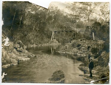 Orbost & District Historical Society
black and white photograph, first half 20th century
This appears to be the Boggy Creek bridge and to have been taken at Nowa Nowa. The Boggy Creek Bridge was built in 1916 as part of the Bairnsdale to Orbost extension to the main Gippsland Railway, and is situated in the middle of the township of Nowa Nowa, crossing a steep-sided and well-timbered creek-valley. This section of the line closed in 1987.This bridge plays a major part in the identity and history of the town of Nowa Nowa, since Boggy Creek’s steep sided valley divides the township into two components. It is part of the East Gippsland Railway line.A black / white photograph of a bridge across a creek. A young man in a suit is standing in the foreground.boggy-creek-bridge-nowa-nowa -
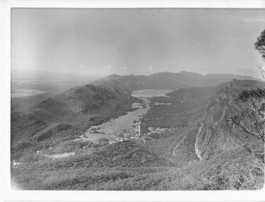 Halls Gap & Grampians Historical Society
Photograph - B/W
Photo has been taken from Boroka Peak/lookout, of the Fyans Valley and the township of Halls Gap. The Grampians/Dunkeld Road can be seen running North/South along the right edge of the valley and Lake Bellfield is the water at the end of the valley. Photo is typical of those taken by Forrests Commission at the timea photo of a valley, mostly cleared, flanked by two mountain ranges. A large body of water can be seen at the far end of the valley (middle of photo). Buildings and roads visible in the valley. Plains can be seen beyond the far mountain range on the left side of the scene.no.42scenery, fyans valley -
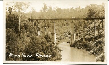 Orbost & District Historical Society
black and white photograph, first half 20th century
This appears to be the Boggy Creek bridge and to have been taken at Nowa Nowa. The Boggy Creek Bridge was built in 1916 as part of the Bairnsdale to Orbost extension to the main Gippsland Railway, and is situated in the middle of the township of Nowa Nowa, crossing a steep-sided and well-timbered creek-valley. This section of the line closed in 1987.This bridge plays a major part in the identity and history of the town of Nowa Nowa, since Boggy Creek’s steep sided valley divides the township into two components. It is part of the East Gippsland Railway line.A black / white photograph / postcard of a tall railway bridge, with concrete pylons in the centre,There is a creek below.on front - bottom left - " NOWA NOWA BRIDGE"boggy-creek-railway-bridge nowa-nowa railway-bridge east-gippsland-railway orbost-bairnsdale-railway -
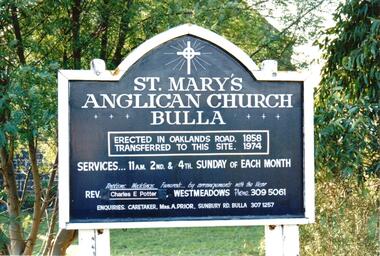 Hume City Civic Collection
Photograph, late 1990s
St. Mary's Anglican Church at Bulla was originally built on the outskirts of Bulla township in 1858. In the early 1970s it was moved to its present site to make way for the flight path at the newly constructed Tullamarine Airport. The former site was on the corner of Oaklands and Sunbury Roads and is covered with vegetation. The church was designed by Thomas Taylor.A coloured photograph of the board which is along the fence line outside St. Mary's Church at Bulla. The white writing is on a navy blue background and is framed in white. The notice gives details of services, clergy and caretaker.churches, religion, anglican church, taylor, thomas, potter, charles e. rev., prior, a., st. mary's anglican church, george evans collection