Showing 2474 items matching " township"
-
 Eltham District Historical Society Inc
Photograph, Shire of Nillumbik World War One Memorials tour, 10 August 2016, 10 August 2016
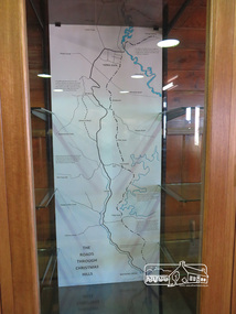
As part of a program to acknowledge the Anzac Centenary Nillumbik Shire Council partnered with Yarra Plenty Regional Library to provide a bus tour with commentary of local sites of significance. These included Eltham township, the Shire of Eltham War Memorial at Kangaroo Ground, Christmas Hills, Hurstbridge memorial recreation park and finshed at Eltham Library to view the Writing the War exhibtion at Eltham Library Community Gallery. Display - The Roads through Christmas Hills in the Christmas Hills Mechanics InstituteBorn Digitalchristmas hills mechanics institute, heritage display -
 Eltham District Historical Society Inc
Photograph, Shire of Eltham War Memorial, 10 August 2016
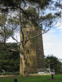
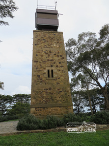
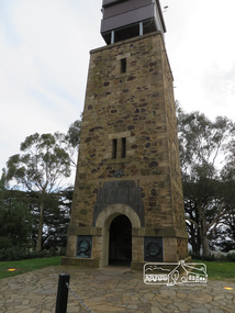
As part of a program to acknowledge the Anzac Centenary Nillumbik Shire Council partnered with Yarra Plenty Regional Library to provide a bus tour with commentary of local sites of significance. These included Eltham township, the Shire of Eltham War Memorial at Kangaroo Ground, Christmas Hills, Hurstbridge memorial recreation park and finished at Eltham Library to view the "Writing the War" exhibition at Eltham Library Community Gallery. Shire of Eltham War memorial at Kangaroo Ground War Memorial ParkBorn Digitalworld war 1, war memorials, shire of nillumbik, kangaroo ground, shire of eltham war memorial, tower, fire spotting cabin, park -
 Orbost & District Historical Society
black and white photographs, February 17 1971
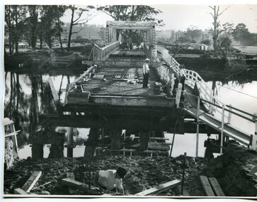
After the damage from the February 1971 floods at Orbost when the abutment to the Snowy River road bridge was washed away a Bailey bridge, portable, pre-fabricated, truss bridge, was put into place to ensure town access, the C.R.B. rebuilt the approach to the bridge driving new piles and constructing the Bailey bridge. They worked late into the night under flood lights to ensure the link from the Orbost township to the Princes Freeway would be open to traffic as soon as possible.These photographs are pictorial records of a significant event in the history of Orbost.Three black / white photographs of a Bailey bridge being erected across a river. 3245.1 and 3245.2 are the same. bailey-bridge orbost-snowy-river-bridge bridge-orbost -
 City of Ballarat
Ceremonial object - Public Artwork, F. W. Commons, Miners Rest Soldiers Memorial by F. W. Commons, 1920
Erected in the township of Miners Rest in 1920 in remembrance of fallen soldiers, this granite plinth cenotaph stands at the West end of an Avenue of Honour with 25 trees. The memorial is of Harcourt colonial granite, with bronze face plates, and contains the names of twenty-four soldiers of the district who sacrificed their lives at war. The monument was designed by the well-known sculptor, Mr F. W. Commons, and the work executed by returned soldiers employed at his studio on Creswick Road, Ballarat.The memorial is of historic and social significance to the people of BallaratGranite stone memorial including plaques on a bluestone base. 4 smaller granite posts and flag pole. In honour of our men of this district who gave their lives in the great war 1914-19. Duty Nobly Done. Erected by residents A.D.1920. Unveiled by Sir A. J. Peacock K.C.M.C., M.L.A. 23rd May 1920 Soldiers named; L.C. Blackman, D.G. Chisholm, J. Dowie, D. Dobson, H. Fisher, A.E. Gray, E.S. Holgate, H.S. Holgate, A. Kennedy, W.C. Kilfeder, G.A. Loader, H.R. Lonsdale, W. Miller, P. Morgan, C.A. Morrison, J. McDonald, N. McKenzie, L. Pollock, W.G. Pollock, A. Robertson, C.F. Shelton, P.J. Shelton, G.F. Smith, J.T. Swain.miners rest cenotaph, miners rest avenue of honour -
 Kew Historical Society Inc
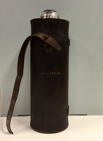
Container - Erica Lines Thermos Flask, 1900-1950
Erica is a town in Victoria, in the Shire of Baw Baw. In the early 1900s, the township of Erica began to grow after construction of the railway line from Moe to Walhalla. When the station opened in 1910 it was named Harris, but was renamed Erica in 1914. Erica was to become the largest town on the Moe-Walhalla railway. The railway line from Moe to Erica closed in 1954. When the item was donated by Raif Brunette in 2007 it was described as a 'Stagecoach thermos flask with leather protective cover'.Metal thermos flask encased in a leather cover embossed with the name 'Erica Lines'."ERICA LINES"erica lines, thermos flasks -
 Linton and District Historical Society Inc
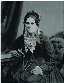
Photograph, Geo Richards studio photographer opposite Star office, Ballarat, Mrs Joseph Linton, nee Mary Dunlop
Mary Linton, nee Dunlop, was born in 1809 the West Indies, and married Joseph Linton in Scotland when she was eighteen. Mary and Joseph Linton migrated to Victoria in 1839, and took up a pastoral lease in the Wardy Yaloak district which they called Emu Hill. They had eleven children, ten of whom survived to adulthood. Mary died in Ballarat in 1887. The township of Linton derives its name from this family. Part of Old Lintonian collection ; No. 12Sepia photograph of a woman wearing a gown with a lace collar and cap, seated with right arm resting on book on table, left arm resting on lap.mrs joseph linton, mary linton, mary dunlop, old lintonian collection -
 Kiewa Valley Historical Society
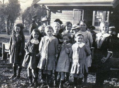
Photo - School Children Tawonga Primary School, Circa 1920 (estimate)
Tawonga is in the Kiewa Valley, where local farmers lived with their families. The school was originally opened July 27 1880, situated on 8 acres near the current township of Tawonga. The school was erased by fire in 1900 and all records destroyed. The school was then moved to the Old Tawonga Hall. In 1910, the school was shifted to its present site on 3 acres of land donated by Frank Cooper. The school building and attendance continued to grow, especially during construction of the Kiewa Hydro Electric Scheme.Tawonga Primary School has educated the local farming and town children for many years. It is an excellent source of the names of the local families of the time ie: Vera Ryder – front row, far right (little girl with the wide headband.)Copy of black and white photograph of pupils at Tawonga Primary School. Circa 1920 (estimate)tawonga primary school, kiewa valley -
 Kiewa Valley Historical Society
Photo - School Children Tawonga Primary School, Circa 1920 (estimate)
Tawonga is in the Kiewa Valley, where local farmers lived with their families. The school was originally opened July 27 1880, situated on 8 acres near the current township of Tawonga. The school was erased by fire in 1900 and all records destroyed. The school was then moved to the Old Tawonga Hall. In 1910, the school was shifted to its present site on 3 acres of land donated by Frank Cooper. The school building and attendance continued to grow, especially during construction of the Kiewa Hydro Electric Scheme.Tawonga Primary School has educated the local farming and town children for many years. It is an excellent source of the names of the local families of the time. Copy of black and white photograph of pupils at Tawonga Primary School. Circa 1920 (estimate)tawonga primary school, kiewa valley -
 Warrnambool and District Historical Society Inc.
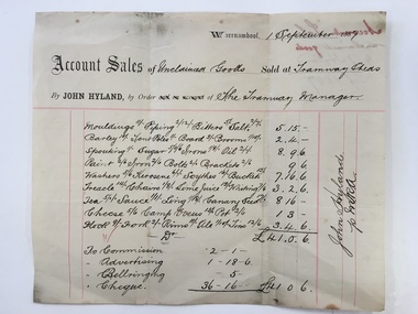
Docket, Hyland/ Tramways Sheds, Circa 1887
In 1858 a tramway was constructed to move goods between Warrnambool township and jetty on Lady Bay. It was established on the south side of Merri St in the approximate site of the present railway station. Large stores were also built near where the present rail lines to hold produce. This docket relates to unclaimed goods and range from tent poles, brooms, sugar scythes, lime juice tea, sauce, camp ovens and ale. John Hyland was the manager who was later mayor of Warrnambool. The Warrnambool tramway was an important part of transportation of goods in the 19th century from the port to the township which was over a mile away. White docket with some text printed in black with other sections handwritten in black pen. Dated September 1887. It shows a list of varied items. Signed John Hyland. “Account sales unclaimed goods by J Hyland Sep 1887” is in red pen on the back. warrnambool, warrnambool tramways, john hyland, unclaimed goods, -
 Warrnambool and District Historical Society Inc.
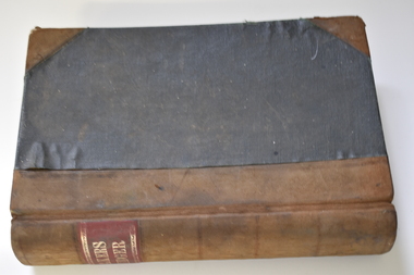
Administrative record - Bakery Ledger, Andrew Jack, Dyson & Co., Melbourne, Baker's Ledger, 1940s
This ledger comes from the Model Bakery business of G.W. Greaves, a baker and pastrycook In Allansford in the first half of the 20th century. Allansford is a township 10 kilometres east of Warrnambool, now incorporated into the City of Warrnambool. The ledger contains details of the Greaves business sales of goods, mostly bread, from 1946 to 1948 and includes the names of the customers, the orders and the moneys owing. The bakery served many nearby areas including Wangoom, Hopkins Point, Cudgee, Mepunga, Naringal and Lake Glllear. This ledger is of interest as it illustrates the size of the Allansford bakery and contains many names of people in the area in the 1940s, making it a valuable research object.This is a ledger with a black cover and leather coverings at the corners and a brown leather spine. The red label on the spine has gold lettering and ornamental edges. The inside of the cover has a red mottled pattern and has tape and string stitching. A maker's label is also inside the front cover. The pages are ruled with red lines and contain handwritten entries. There are some loose invoices. The cover is very faded and stained.Baker's Ledger Andrew Jack, Dyson & Co. Wholesale Stationersallansford bakery, greaves model bakery -
 Eltham District Historical Society Inc
Photograph, Shire of Nillumbik World War One Memorials tour, 10 August 2016, 10 August 2016
As part of a program to acknowledge the Anzac Centenary Nillumbik Shire Council partnered with Yarra Plenty Regional Library to provide a bus tour with commentary of local sites of significance. These included Eltham township, the Shire of Eltham War Memorial at Kangaroo Ground, Christmas Hills, Hurstbridge memorial recreation park and finished at Eltham Library to view the Writing the War exhibtion at Eltham Library Community Gallery. The Shire of Eltham War Memorial at Kangaroo Ground War Memorial Park with fire spotting tower additon. Born Digitalworld war 1, war memorials, shire of nillumbik, kangaroo ground, memorial park, war memorial, fire spotting tower -
 Eltham District Historical Society Inc
Photograph, Shire of Nillumbik World War One Memorials tour, 10 August 2016, 10 August 2016
As part of a program to acknowledge the Anzac Centenary Nillumbik Shire Council partnered with Yarra Plenty Regional Library to provide a bus tour with commentary of local sites of significance. These included Eltham township, the Shire of Eltham War Memorial at Kangaroo Ground, Christmas Hills, Hurstbridge memorial recreation park and finished at Eltham Library to view the Writing the War exhibtion at Eltham Library Community Gallery. Shire of Eltham War Memorial with fire spotting tower at Kangaroo Ground War Memorial Park Born Digitalworld war 1, war memorials, shire of nillumbik, kangaroo ground, shire of eltham war memorial -
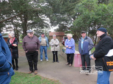 Eltham District Historical Society Inc
Photograph, Shire of Nillumbik World War One Memorials tour, 10 August 2016, 10 August 2016
As part of a program to acknowledge the Anzac Centenary Nillumbik Shire Council partnered with Yarra Plenty Regional Library to provide a bus tour with commentary of local sites of significance. These included Eltham township, the Shire of Eltham War Memorial at Kangaroo Ground, Christmas Hills, Hurstbridge memorial recreation park and finished at Eltham Library to view the Writing the War exhibtion at Eltham Library Community Gallery. Dennis Ward (right hand side) of "The Friends of Kangaroo Tower" gives a brief presentation about the site. Born Digitalworld war 1, war memorials, shire of nillumbik, kangaroo ground, kangaroo ground memorial, tour, dennis ward -
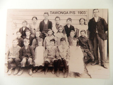 Kiewa Valley Historical Society
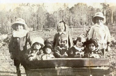
Photo - Copy of Tawonga Primary School 1903, Tawonga Primary School, 1903 - original
Tawonga is in the Kiewa Valley where farmers lived with their families. The school was opened on 27th July 1880 situated on 8 acres near the current township of Tawonga. This school was erased by fire in 1900 and all records were destroyed. The school then moved to the old Tawonga Hall. In 1910 the school was shifted to its present site on 3 acres of land donated by Frank Cooper. The school building and attendance continued to grow especially during the construction of the Kiewa Hydro Electric Scheme. Historic: Tawonga Primary school has educated the local farming and town children for many years. It is an excellent source of the names of the local families in 1903. The photo is taken outside the Old Tawonga hall where the school was situated in 1903 and shows the clothing worn by children and teachers at the time.Teacher and 20 students in school photo. "Tawonga Primary School 1903" added digitally when the photo was copied. There is a typed list of all names.Names of students. Back Row: Charlotte Cooper, John Cooper, Ada Cooper, Thomas Hollands, Irene Roper, Stewart Hollands, Lily Barnette. Teacher Donald Mc Cance. Centre Row: Edward Trebilcock, Alfred Hollands, Pearl Barnette, Frank Cooper, Nellie Higginson, Bert Roper, Reg Roper. Front Row: Ben Cooper, Raymond Cooper, Myrtle Barnette, Lewis Crotty, John Creamer, Annie Hollandstawonga primary school. education. kiewa valley. cooper family -
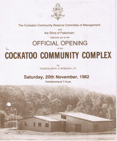 Cockatoo History & Heritage Group
Order of Ceremony, Official Opening of the Cockatoo Community Complex, Saturday 20th November, 1982
In 1976, the Shire of Pakenham recognising that Cockatoo was the second largest township within the shire, acknowledged requests for the provision of recreation facilities. Council purchased four hectares of land strategically located in the Town Centre and in conjunction with the local community, embarked upon a programme of staged development of the site. The first stage saw the construction of the kindergarten building which was opened in 1977, followed by the bowling green, tennis courts, netball courts and public toilets. The Community Complex Building was the final development of the site.The Cockatoo Community Complex building, was the final stage of the development and was opened on the 20th November 1982. It was a replacement for the old Cockatoo Hall, which had not been renovated since 1936. The old Cockatoo Hall was lost in the Ash Wednesday fires on the 16th February 1983. The community complex played an integral part in the recovery stages after Ash Wednesday.Four page document, including Acknowledgements, Order of Ceremony, Menu and Site Plan of the Cockatoo community ComplexTwo punctured holes for folder storagecockatoo community complex, cockatoo hall, hall opening, cockatoo -
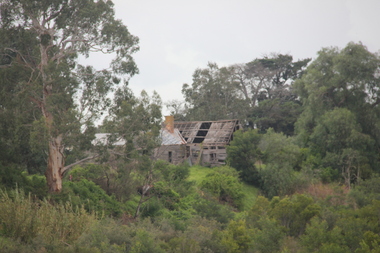 Victorian Interpretive Projects Inc.
Photograph - colour, Lisa Gervasoni, Ruins of Angus McMillan's original Bushy Park Homestead near Maffra, 2014, 07/06/2014
Angus McMillan named the Avon River after the river of the same name in his native Scotland. In 1840 he established a pastoral run at Bushy Park, north-west of the township. William Odell Raymond established a run in the area in 1842, and built his house, Strathfieldsaye, during 1848–54. European settlement did not take place without resistance, and in return, massacres were inflicted by Angus McMillan and others on Gunai people, especially between the years of 1840 and 1850. (wikipedia)bushy park, angus mcmillan, avon river -
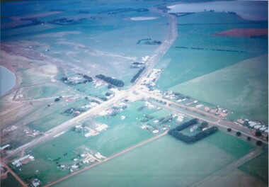 Lake Bolac & District Historical Society
Colour photograph
Aerial view of Lake Bolac township, looking towards the north-east, taken circa 1968. The freshwater lake is top-right, the salt-lake is centre-left. The Presbyterian church, bottom right, is surrounded by Cyprus trees on the Woorndoo/Mortlake road. The hotel and general store are opposite each other on the crossroads of the Mortlake/Ararat and Ballarat/Hamilton roads and the sporting complex is behind the store next to the salt lake. The Primary School, No 854, is between the footy oval and the Ararat Road, centre left.lake bolac, freshwater lake, salt lake, presbyterian church, hotel, general store, sporting complex, primary school, no 854. -
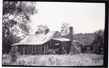 Whitehorse Historical Society Inc.
Photograph, Schwerkolt Cottage, 1962
Photo sent to Mary Jack, Pittsburgh USA by Charles Schwerkolt. Accompanying text sent by Charles - 'This is another photo of front side (facing Mitcham township) You see there is a lot of dried grass lying about which is a serious fire risk to the new houses which have been built. The verandah posts on the corner have rotted away and let the verandah down a foot. The roof on the kitchen is in a bad way. You will notice the chimney has a lean of about a foot. Black and white photo of Schwerkolt Cottage showing the Rotting Verandah Posts and Leaning Chimney. Thin Black Border.schwerkolt, charles clarence victor, whalen, rosalie, jackschowsky, mary elizabeth, schwerkolt cottage -
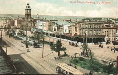 Ballarat Tramway Museum
Postcard - copy, Sovereign Hill and Gold Museum, "Sturt St, looking E., Ballarat", c2000
Postcard Photo of Sturt St looking East from about Dawson St with the shops on the southern side and the Town Hall in the view. Has an ESCo tram in the bottom right hand corner. Card reproduced for Sovereign Hill Gold Mining Township by Rose Stereograph Co. of Glen Waverley c2000. Divided back type with caption, production and the Rose Co. symbol on the rear. See item 9005 for a small used black and white version with more detail of the tram.Yields information about the appearance of Sturt St following the introduction of electric trams in 1905 and has a strong association with the work of Sovereign Hill and Rose Stereograph Co.Postcard reproduction - full colour divided back unused.trams, tramways, sturt st, ballarat, esco, rose postcards -
 Sunbury Family History and Heritage Society Inc.
Photograph, Painting school sign, 1988
In 1988, the senior students at Bulla Primary School, under the supervision of their teacher undertook a community activity to paint a school sign that could be seen from a distance. They collected rocks that were lying across the exposed hillside above the school and arranged them into the word 'BULLA'. They then painted the rocks with white paint. Anyone approaching Bulla township from Sunbury would see the sign across the valley. The sign remained there for the following eight years but was dismantled when the school property was sold.The painted sign on the hillside became an important signpost for people travelling into the township as it was visible even from a low flying aircraft, which were either descending to land or had just taken off from the nearby airport.A non-digital coloured photograph of four children and an adult painting rocks on a hillside.bulla primary school, school painted sign, bulla township -
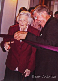 Melton City Libraries
Photograph, Edna Barrie, Unknown
Over 20 years commencing in the 1970s, Edna undertook extensive photographing of the changing streetscape of Melton’s High Street. She anticipated the impact of change on the community during the time of Melton’s rapid transition from a small farming district to a large urban community and this led to her extensively document and photograph many of the structures and landscape features of the township that have since been lost. She also meticulously recorded much of the contemporary life of the town and has left a significant legacy of archival material. Edna Barrie cutting a ribbon to an opening of a eventlocal identities, pioneer families -
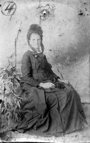 Linton and District Historical Society Inc
Photograph, Mary Linton née Dunlop (Mrs Joseph Linton)
Photograph is part of Old Lintonian collection ; No. 4. Mary Linton, nee Dunlop, was born in 1809 the West Indies, and married Joseph Linton in Scotland when she was eighteen. Mary and Joseph Linton migrated to Victoria in 1839, and took up a pastoral lease in the Wardy Yaloak district which they called Emu Hill. They had eleven children, ten of whom survived to adulthood. Mary died in Ballarat in 1887. The township of Linton derives its name from this family.Sepia photograph of a lady wearing long gown and hat, seated with arms resting on her lap.mrs joseph linton, old lintonian collection, mary linton nee dunlop -
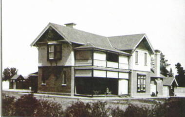 Sunbury Family History and Heritage Society Inc.
Photograph, Ardcloney House
The two storey house is 'Ardcloney. Dr. William Faulkner, formerly from Queensland, had it built for his residence in 1911. The property also included a garage, which accommodated his automobile and accommodation for his chauffeur. Owners in more recent times were Keith Campbell, who previously owned 'Willowbank' in the old Broadmeadows township and Bill Landeroo a former Victorian State MP. The buildings and surrounds have been redeveloped and the property is now the Sunbury Day Care Hospital.'Ardcloney' is one of Sunbury's significant historical properties in the town.A non-digital black and white photograph of a two- storey Californian style mansion in a garden setting. The ground floor is constructed of bricks and the upper storey of timber. The roof is tiled. The image is a copy of an original photograph. ardcloney, dr. william faulkner, sunbury, sunbury day care hospital -
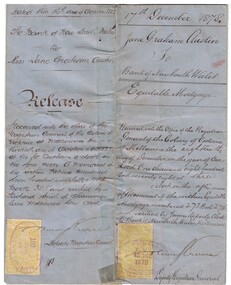 Linton and District Historical Society Inc
Mortgage document, Mortgage Document, 1878, and Mortgage Release, 1882
Jane Graham Austin purchased Allotment 14, Section 1, Township of Linton in 1871. This property, a house and shop in Sussex Street next to the Shire Hall, had formerly been owned by her father, Thomas Austin, who was forced to sell it after being declared insolvent. Jane Austin mortgaged the property for £20 in 1878. When Thomas Austin left Linton in 1882, his daughter sold the property to Benjamin Dodd, who in turn sold it in 1887 to John Angus.Approximately A3-size sheet of blue paper which has been folded twice. Printed and handwritten documentation of the 'Equitable Mortgage' arrangement entered into by Jane Graham Austin with the Bank of New South Wales in December 1878. The release of the mortgage, in October 1882, is also documented. Two half-crown Victorian stamps, one dated 18 Dec1878 and one dated Oct 1882, are affixed to the document.jane graham austin, bank of new south wales, mortgage documents, simson -
 Sunbury Family History and Heritage Society Inc.
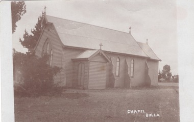
Photograph, Chapel Bulla
The church in the image is the former St. Michaels Catholic Church that was on Sunbury Road in the small Bulla township. After holding religious services at the Daniel property 'Narbonne' at Oaklands Junction until 1876, the permanent church building opened 0n 19th November 1876. Services were held there until the land was sold in the 1980s and the building was demolished despite undergoing renovations in 1978. Members of the Catholic faith then worshipped at the Sunbury Catholic Church. The note on the flip side was written by a Sunbury resident to his sister.A post card with a non-digital sepia photograph of a weatherboard church in an open grassed area. A short note has been written on the flip side of the card.st. michaels church, bulla, catholic church -
 Federation University Historical Collection
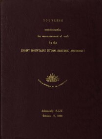
book, Truth & Sportsman Ltd, Souvenir commemorating the commencement of work by the Snowy mountains hydro-electric authority, 17/10/1949
It is assumed that a member of the Ballarat School of Mines attended the commencement of work at the Snowy Mountains hydro-electric centre.Burgundy cover with gold printing. Black print, photos and diagrams on white paper (31 pages). Bound by 3 staples. The contents include the story of the Snowy. Images include W.J. McKell, J.B. (Ben) Chifley, J. McGirr, Nelson Lemmon, Hume Weir, Jindabyne valley (now flooded), Jindabyne township (now flooded), illustration of water Power, survey team at Adaminaby, Snowy Mountains Relief Plan, Horseman crossing the Eucumbene River, Mildura, Burrinjuck Dam under construction, transmission lines, W. Hudson.snowy mountains hydro-electricty scheme, snowy mountains hydro-electric authority -
 Bendigo Historical Society Inc.
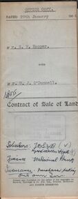
Document - H.A. & S.R. WILKINSON COLLECTION: CONDITION OF SALE
Contract of sale of land dated 29th January 1954 between Mr. E.M. Hopper (seller) and Mr. G.J. O'Donnell (buyer) for land being Lot 2 on plan of subdivision No. 23332 registered in the office of titles, Melbourne and situate in Lindsay Street Kangaroo Flat part of Crown allotment 11 section 23, township of Kangaroo Falt described in Certificate of title volume 7446 folio 423, together with weatherboard dwelling, wood shed-lavatory also fencing on the said land. Price 2,700 pounds.organization, business, h.a. & s.r wilkinson real estate -
 Bendigo Historical Society Inc.
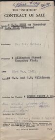
Document - H.A. & S.R. WILKINSON COLLECTION: CONTRACT OF SALE
Contract of sale dated 23rd May, 1961 between G.H. Bush as Executor of of the will of E.M. Muir deceased (vendor) and Mr. P. J. Sutton (purchaser). Solicitor for vendor: Comen Kirby & co. Solicitor for Purchaser: Messrs. Watson, James & Rogers, Bull Street, Bendigo. Property: Allingham Street Kangaroo Flat, being Crown allotment 71 section D township of Kangaroo Flat described in certificate of tilte volume 6613 folio 483, together with all buildings and erection thereon. Price 300 pounds.organization, business, h.a. & s.r wilkinson real estate -
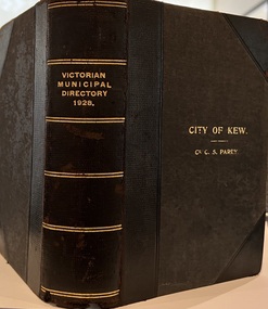 Kew Historical Society Inc
Journal, Arnall & Jackson: Printers & Stationers, Victorian Municipal Directory and Gazetteer : Also Commonwealth Guide and the Water Supply Record for 1928
The Victorian Municipal Directory provided annual details, and later bi-annual details, of all councils. Published by Arnall & Jackson (Printers and Stationers), copies were published in 'cloth' for sixteen shillings and 'half roan' for eighteen shillings. This copy was owned by Cr C.S.Parry. Elected to the Kew City Council as a representative of North Ward, Cr Parry was elevated to the position of Mayor in 1931. It, together with five other editions, was presented to the Kew Historical Society in 1987 by his grandson.Bound copy of the Victorian Municipal Directory and Gazetteer: Also Commonwealth Guide and the Water Supply Record for 1928. The volume contains 846 pages and includes sections on: - Comparative table – Municipal Returns for Twenty-one Years. - Index to Townships, Parishes and Railway Stations. - Changes and appointments. - Commonwealth of Australia (Constitution, Parliament, Departments and Officers). - State of Victoria (Parliament, Departments and Officers / Boards, Institutions, Trusts and Loans). - Municipalities in Victoria (Cities and Towns, Boroughs, Shires). - Water Supply (State Rivers and Water Supply Commission).non-fictionThe Victorian Municipal Directory provided annual details, and later bi-annual details, of all councils. Published by Arnall & Jackson (Printers and Stationers), copies were published in 'cloth' for sixteen shillings and 'half roan' for eighteen shillings. This copy was owned by Cr C.S.Parry. Elected to the Kew City Council as a representative of North Ward, Cr Parry was elevated to the position of Mayor in 1931. It, together with five other editions, was presented to the Kew Historical Society in 1987 by his grandson. victoria -- registers -- periodicals., victoria -- directories., water-supply -- victoria -- directories., municipal government -- victoria -- periodicals., cities and towns -- victoria -- directories. -
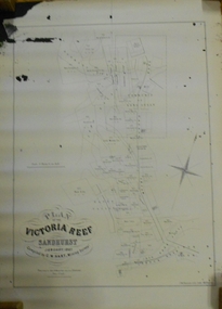 Bendigo Historical Society Inc.
Document - MARKS COLLECTION: MAP OF VICTORIA REEF MINING CLAIMS
Copy of map. On bottom LH side: Plan of the Victoria Reef Sandhurst January 1867, Compiled by G.W. Hart, Mining Surveyor. Published by John N. Macartney, Argus Agent, Sandhurst. Price 4/- each. On bottom Rh side J.W. Pearson & Co. Lith. Melbourne Plan shows mining claims and names of holders, scale (4 chains to one inch) Loddon Road, Mount Korong Road, Ironbark Gully, township of Long Gully, Quartz Miners' Arms and Gold Mines Hotel on Loddon Road.bendigo, mining, victoria reef plan