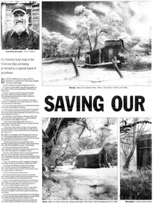
Showing 1969 items matching "tourist"
-
 Orbost & District Historical Society
black and white photograph, 1920s
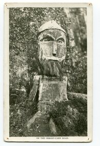
Pons asinorum was the name given to a wooden carving made by road worker Finlay Munro in the early 1920s at Boulder Creek, on the old Princess Highway, between Orbost and Cann River. The carved face was said to mock the supervising engineer after an argument about putting the road alignment across a swamp that required new bridges. The Italian workmen had advocated for a different route to avoid the need for building new bridges across the swamp. This photograph is from a set of thirteen black and white postcards in a fold-out format.This is a photograph of an iconic tourist attraction which records the woodworking skills of workers in the early 20th century. The carving is no longer there.A small black / white photograph of a face carved into a tree stump.on front at bottom - ON THE ORBOST CANN ROADwoodcarving pons-asinorum boulder-creek-east-gippsland princess-highway -
 Flagstaff Hill Maritime Museum and Village
Functional object - Ship's Wheel, 1871 or earlier
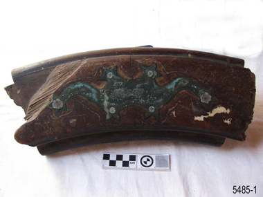
The ship building company E. & A. Sewall, from Bath, Maine, USA, built many ships that had wheels with the same decorative, starburst pattern on them as this particular wheel segment, including the Eric the Red. The wheel was manufactured by their local Bath foundry, Geo. Moulton & Co. and sold to the Sewall yard for $100, according to the construction accounts of the vessel. Eric the Red was a wooden, three masted clipper ship. She had 1,580 tons register and was the largest full-rigged ship built at Bath, Maine, USA in 1871. She was built and registered by Arthur Sewall, later to become the partnership E. & A. Sewall, and was the 51st ship built by this company. The annually-published List of Merchant Vessels of the U.S. shows that Bath was still the home port of Eric the Red in 1880. The vessel was named after the Viking discoverer, Eric the Red, who was the first European to reach the shores of North America (in 980AD). The ship Eric the Red at first traded in coal between America and Britain, and later traded in guano nitrates from South America. In 1879 she was re-metalled and was in first class condition. On 10th June 1880 (some records say 12th June) Eric the Red departed New York for Melbourne and then Sydney. She had been commissioned by American trade representatives to carry a special cargo of 500 exhibits (1400 tons) - about a quarter to a third of America’s total exhibits - from America for the U.S.A. pavilion at Melbourne’s first International Exhibition. The exhibits included furniture, ironmongery, wines, chemicals, dental and surgical instruments, paper, cages, bronze lamp trimmings, axles, stamped ware, astronomical and time globes, samples of corn and the choicest of leaf tobacco. Other general cargo included merchandise such as cases of kerosene and turpentine, brooms, Bristol's Sarsaparilla, Wheeler and Wilson sewing machines, Wheeler’s thresher machine, axe handles and tools, cases of silver plate, toys, pianos and organs, carriages and Yankee notions. The Eric the Red left New York under the command of Captain Z. Allen (or some records say Captain Jacques Allen) and 24 other crew including the owner’s son third mate Ned Sewall. There were 2 saloon passengers also. On 4th September 1880 the ship had been sailing for an uneventful 85 days and the voyage was almost at its end. Eric the Red approached Cape Otway in a moderate north-west wind and hazy and overcast atmosphere. Around 1:30am Captain Allen sighted the Cape Otway light and was keeping the ship 5-6 miles offshore to stay clear of the hazardous Otway Reef. However he had badly misjudged his position. The ship hit the Otway Reef about 2 miles out to sea, south west of the Cape Otway light station. Captain Allen ordered the wheel to be put ‘hard up’ thinking that she might float off the reef. A heavy sea knocked the man away from the wheel, broke the wheel ropes and carried away the rudder. The sea swamped the lifeboats, the mizzenmast fell, with all of its rigging, then the mainmast fell and the ship broke in two. Some said that the passenger Vaughan, who was travelling for his health and not very strong, was washed overboard and never seen again. The ship started breaking up. The forward house came adrift with three of the crew on it as well as a longboat, which the men succeeded in launching and keeping afloat by continually bailing with their sea boots. The captain, the third mate (the owner’s son) and others clung to the mizzenmast in the sea. Then the owner’s son was washed away off the mast. Within 10 minutes the rest of the ship was in pieces, completely wrecked, with cargo and wreckage floating in the sea. The captain encouraged the second mate to swim with him to the deckhouse where there were other crew but the second mate wouldn’t go with him. Eventually the Captain made it to the deckhouse and the men pulled him up. At about 4:30am the group of men on the deckhouse saw the lights of a steamer and called for help. At the same time they noticed the second mate and the other man had drifted nearby, still on the spur, and pulled them both onto the wreck. The coastal steamer Dawn was returning to Warrnambool from Melbourne, its sailing time different to its usual schedule. Cries were heard coming from out of the darkness. Captain Jones sent out two life boats, and fired off rockets and blue lights to illuminate the area. They picked up the three survivors who were in the long boat from Eric the Red. Two men were picked up out of the water, one being the owner’s son who was clinging to floating kerosene boxes. At daylight the Dawn then rescued the 18 men from the floating portion of the deckhouse, which had drifted about 4 miles from where they’d struck the reef. Shortly after the rescue the deckhouse drifted onto breakers and was thrown onto rocks at Point Franklin, about 2 miles east of Cape Otway. Captain Jones had signalled to Cape Otway lighthouse the number of the Eric the Red and later signalled that there was a wreck at Otway Reef but there was no response from the lighthouse. The captain and crew of the Dawn spent several more hours searching unsuccessfully for more survivors, even going back as far as Apollo Bay. On board the Dawn the exhausted men received care and attention to their needs and wants, including much needed clothing. Captain Allen was amongst the 23 battered and injured men who were rescued and later taken to Warrnambool for care. Warrnambool’s mayor and town clerk offered them all hospitality, the three badly injured men going to the hospital and others to the Olive Branch Hotel, then on to Melbourne. Captain Allen’s leg injury prevented him from going ashore so he and three other men travelled on the Dawn to Portland. They were met by the mayor who also treated them all with great kindness. Captain Allen took the train back to Melbourne then returned to America. Those saved were Captain Z. Allen (or Jacques Allen), J. Darcy chief mate, James F. Lawrence second mate, Ned Sewall third mate and owner’s son, John French the cook, C. Nelson sail maker, Clarence W. New passenger, and the able seamen Dickenson, J. Black, Denis White, C. Herbert, C. Thompson, A. Brooks, D. Wilson, J. Ellis, Q. Thompson, C. Newman, W. Paul, J. Davis, M. Horenleng, J. Ogduff, T. W. Drew, R. Richardson. Four men had lost their lives; three of them were crew (Gus Dahlgreen ship’s carpenter, H. Ackman steward, who drowned in his cabin, and George Silver seaman) and one a passenger (J. B. Vaughan). The body of one of them had been found washed up at Cape Otway and was later buried in the lighthouse cemetery; another body was seen on an inaccessible ledge. Twelve months later the second mate James F. Lawrence, from Nova Scotia, passed away in the Warrnambool district; an obituary was displayed in the local paper. The captain and crew of the Dawn were recognised by the United States Government in July 1881 for their humane efforts and bravery, being thanked and presented with substantial monetary rewards, medals and gifts. Neither the ship, nor its cargo, was insured. The ship was worth about £15,000 and the cargo was reportedly worth £40,000; only about £2,000 worth had been recovered. Cargo and wreckage washed up at Apollo Bay, Peterborough, Port Campbell, Western Port and according to some reports, even as far away as the beaches of New Zealand. The day after the wreck the government steam ship Pharos was sent from Queenscliff to clear the shipping lanes of debris that could be a danger to ships. The large midship deckhouse of the ship was found floating in a calm sea near Henty Reef. Items such as an American chair, a ladder and a nest of boxes were all on top of the deckhouse. As it was so large and could cause danger to passing ships, Captain Payne had the deckhouse towed towards the shore just beyond Apollo Bay. Between Apollo Bay and Blanket Bay the captain and crew of Pharos collected Wheeler and Wilson sewing machines, nests of boxes, bottles of Bristol’s sarsaparilla, pieces of common American chairs, axe handles, a Wheelers’ Patent thresher and a sailor’s trunk with the words “A. James” on the front. A ship’s flag-board bearing the words “Eric the Red” was found on the deckhouse; finally those on board the Pharos had the name of the wrecked vessel. During this operation Pharos came across the government steamer Victoria and also a steamer S.S. Otway, both of which were picking up flotsam and wreckage. A whole side of the hull and three large pieces of the other side of the hull, with some of the copper sheathing stripped off, had floated on to Point Franklin. Some of the vessels yards and portions of her masts were on shore. The pieces of canvas attached to the yards and masts confirmed that the vessel had been under sail. The beach there was piled with debris several feet high. There were many cases of Diamond Oil kerosene, labelled R. W. Cameron and Company, New York. There were also many large planks of red pine, portions of a small white boat and a large, well-used oar. Other items found ashore included sewing machines (some consigned to ‘Long and Co.”) and notions, axe and scythe handles, hay forks, wooden pegs, rolls of wire (some branded “T.S” and Co, Melbourne”), kegs of nails branded “A.T. and Co.” from the factory of A. Field and Son, Taunton, Massachusetts, croquet balls and mallets, buggy fittings, rat traps, perfumery, cutlery and Douay Bibles, clocks, bicycles, chairs, a fly wheel, a cooking stove, timber, boxes, pianos, organs and a ladder. (Wooden clothes pegs drifted in for many years). There seemed to be no personal luggage or clothing. The Pharos encountered a long line, about one and a half miles, of floating wreckage about 10 miles off land, south east of Cape Otway, and in some places about 40 feet wide. It seemed that more than half of it was from Eric the Red. The ship’s crew rescued 3 cases that were for the Melbourne Exhibition and other items from amongst the debris. There were also chairs, doors, musical instruments, washing boards, nests of trunks and fly catchers floating in the sea. Most of the goods were saturated and smelt of kerosene. A section of the hull lies buried in the sand at Parker River Beach. An anchor with chain is embedded in the rocks east of Point Franklin and a second anchor, thought to be from Eric the Red, is on display at the Cape Otway light station. (There is a photograph of a life belt on the verandah of Rivernook Guest House in Princetown with the words “ERIC THE RED / BOSTON”. This is rather a mystery as the ship was registered in Bath, Maine, USA.) Parts of the ship are on display at Bimbi Park Caravan Park and at Apollo Bay Museum. Flagstaff Hill Maritime Village also has part of the helm (steering wheel), a carved wooden sword (said to be the only remaining portion of the ship’s figurehead; further research is currently being carried out), a door, a metal rod, samples of wood and a medal for bravery. Much of the wreckage was recovered by the local residents before police and other authorities arrived at the scene. Looters went to great effort to salvage goods, being lowered down the high cliff faces to areas with little or no beach to collect items from the wreckage, their mates above watching out for dangerous waves. A Tasmanian newspaper reports on a court case in Stawell, Victoria, noting a man who was caught 2 months later selling tobacco from the wreckage of Eric the Red. Some of the silverware is still treasured by descendants of Mr Mackenzie who was given these items by officials for his help in securing the cargo. The gifts included silver coffee and tea pots, half a dozen silver serviette rings and two sewing machines. The wreck and cargo were sold to a Melbourne man who salvaged a quantity of high quality tobacco and dental and surgical instruments. Timbers from the ship were salvaged and used in the construction of houses and sheds around Apollo Bay, including a guest house, Milford House (since burnt down in bushfires), which had furniture, fittings and timber on the dining room floor from the ship. A 39.7 foot long trading ketch, the Apollo, was also built from its timbers by Mr Burgess in 1883 and subsequently used in Tasmanian waters. It was the first attempt at ship building in Apollo bay. In 1881 a red light was installed about 300 feet above sea level at the base of the Cape Otway lighthouse to warn ships when they were too close to shore; It would not be visible unless a ship came within 3 miles from it. This has proved to be an effective warning. The State Library of Victoria has a lithograph in its collection depicting the steamer Dawn and the shipwrecked men, titled. "Wreck of the ship Eric the Red, Cape Otway: rescue of the crew by the Dawn". “The Eric the Red is historically significant as one of Victoria's major 19th century shipwrecks. (Heritage Victoria Eric the Red; HV ID 239) The wreck led to the provision of an additional warning light placed below the Cape Otway lighthouse to alert mariners to the location of Otway Reef. The site is archaeologically significant for its remains of a large and varied cargo and ship's fittings being scattered over a wide area. The site is recreationally and aesthetically significant as it is one of the few sites along this coast where tourists can visit identifiable remains of a large wooden shipwreck, and for its location set against the background of Cape Otway, Bass Strait, and the Cape Otway lighthouse.“ (Victorian Heritage Database Registration Number S239, Official Number 8745 USA) Segment of a ship's wheel, or helm, from the wreck of the sailing ship Eric the Red. The wheel part is an arc shape from the outer rim of the wheel and is made up of three layers of timber. The centre layer is a dark, dense timber and is wider than the two outer layers, which are less dense and lighter in colour. The wheel segment has a vertically symmetrical, decorative copper plate inlaid on the front. The plate has a starburst pattern; six stars decorate it, each at a point where there is a metal fitting going through the three layers of timber to the rear side of the wheel. On the rear each of the six fittings has an individual copper star around it. The edges of the helm are rounded and bevelled, polished to a shine in a dark stain. Around each of the stars, front and back, the wood is a lighter colour, as though the metal in that area being polished frequently. The length of the segment suggests that it has probably come from a wheel or helm that had ten spokes. (Ref: F.H.M.M. 16th March 1994, 239.6.610.3.7. Artefact Reg No ER/1.)flagstaff hill, warrnambool, shipwrecked-coast, flagstaff-hill, flagstaff-hill-maritime-museum, maritime-museum, shipwreck-coast, flagstaff-hill-maritime-village, ship's-wheel, eric-the-red, helm, shei's wheel, ship's steering wheel -
 Flagstaff Hill Maritime Museum and Village
Decorative object - Sword, 1871 or earlier
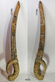
This wooden sword is said to “possibly be the only remaining part of the figurehead from the sailing ship Eric the Red.” It was previously part of the collection of the old Warrnambool Museum and the entry in its inventory says “Wooden sword, portion of the figurehead, held by “Eric the Red” at the bow.” A large part of the ship’s hull was found on the rocks and a figurehead may have been attached or washed up on the shore. The shipping records for E. & A. Sewall, the builders, owners and managers of Eric the Red, are now preserved in the Maine Maritime Museum. There is no photograph on record of Eric the Red but photographs of other ships built around that time by the same company show that these did not have figureheads, and there is no record found of a figurehead for Eric the Red being ordered or paid for. Further research is being carried out. The ship building company E. & A. Sewall, from Bath, Maine, USA, built Eric the Red, a wooden, three masted clipper ship. She had 1,580 tons register and was the largest full-rigged ship built at Bath, Maine, USA in 1871. She was built and registered by Arthur Sewall, later to become the partnership E. & A. Sewall, and was the 51st ship built by this company. The annually-published List of Merchant Vessels of the U.S. shows that Bath was still the home port of Eric the Red in 1880. The vessel was named after the Viking discoverer, Eric the Red, who was the first European to reach the shores of North America (in 980AD). The ship Eric the Red at first traded in coal between America and Britain, and later traded in guano nitrates from South America. In 1879 she was re-metalled and was in first class condition. On 10th June 1880 (some records say 12th June) Eric the Red departed New York for Melbourne and then Sydney. She had been commissioned by American trade representatives to carry a special cargo of 500 exhibits (1400 tons) - about a quarter to a third of America’s total exhibits - from America for the U.S.A. pavilion at Melbourne’s first International Exhibition. The exhibits included furniture, ironmongery, wines, chemicals, dental and surgical instruments, paper, cages, bronze lamp trimmings, axles, stamped ware, astronomical and time globes, samples of corn and the choicest of leaf tobacco. Other general cargo included merchandise such as cases of kerosene and turpentine, brooms, Bristol's Sarsaparilla, Wheeler and Wilson sewing machines, Wheeler’s thresher machine, axe handles and tools, cases of silver plate, toys, pianos and organs, carriages and Yankee notions. The Eric the Red left New York under the command of Captain Z. Allen (or some records say Captain Jacques Allen) and 24 other crew including the owner’s son third mate Ned Sewall. There were 2 saloon passengers also. On 4th September 1880 the ship had been sailing for an uneventful 85 days and the voyage was almost at its end. Eric the Red approached Cape Otway in a moderate north-west wind and hazy and overcast atmosphere. Around 1:30am Captain Allen sighted the Cape Otway light and was keeping the ship 5-6 miles offshore to stay clear of the hazardous Otway Reef. However he had badly misjudged his position. The ship hit the Otway Reef about 2 miles out to sea, south west of the Cape Otway light station. Captain Allen ordered the wheel to be put ‘hard up’ thinking that she might float off the reef. A heavy sea knocked the man away from the wheel, broke the wheel ropes and carried away the rudder. The sea swamped the lifeboats, the mizzenmast fell, with all of its rigging, then the mainmast fell and the ship broke in two. Some said that the passenger Vaughan, who was travelling for his health and not very strong, was washed overboard and never seen again. The ship started breaking up. The forward house came adrift with three of the crew on it as well as a longboat, which the men succeeded in launching and keeping afloat by continually bailing with their sea boots. The captain, the third mate (the owner’s son) and others clung to the mizzenmast in the sea. Then the owner’s son was washed away off the mast. Within 10 minutes the rest of the ship was in pieces, completely wrecked, with cargo and wreckage floating in the sea. The captain encouraged the second mate to swim with him to the deckhouse where there were other crew but the second mate wouldn’t go with him. Eventually the Captain made it to the deckhouse and the men pulled him up. At about 4:30am the group of men on the deckhouse saw the lights of a steamer and called for help. At the same time they noticed the second mate and the other man had drifted nearby, still on the spur, and pulled them both onto the wreck. The coastal steamer Dawn was returning to Warrnambool from Melbourne, its sailing time different to its usual schedule. Cries were heard coming from out of the darkness. Captain Jones sent out two life boats, and fired off rockets and blue lights to illuminate the area. They picked up the three survivors who were in the long boat from Eric the Red. Two men were picked up out of the water, one being the owner’s son who was clinging to floating kerosene boxes. At daylight the Dawn then rescued the 18 men from the floating portion of the deckhouse, which had drifted about 4 miles from where they’d struck the reef. Shortly after the rescue the deckhouse drifted onto breakers and was thrown onto rocks at Point Franklin, about 2 miles east of Cape Otway. Captain Jones had signalled to Cape Otway lighthouse the number of the Eric the Red and later signalled that there was a wreck at Otway Reef but there was no response from the lighthouse. The captain and crew of the Dawn spent several more hours searching unsuccessfully for more survivors, even going back as far as Apollo Bay. On board the Dawn the exhausted men received care and attention to their needs and wants, including much needed clothing. Captain Allen was amongst the 23 battered and injured men who were rescued and later taken to Warrnambool for care. Warrnambool’s mayor and town clerk offered them all hospitality, the three badly injured men going to the hospital and others to the Olive Branch Hotel, then on to Melbourne. Captain Allen’s leg injury prevented him from going ashore so he and three other men travelled on the Dawn to Portland. They were met by the mayor who also treated them all with great kindness. Captain Allen took the train back to Melbourne then returned to America. Those saved were Captain Z. Allen (or Jacques Allen), J. Darcy chief mate, James F. Lawrence second mate, Ned Sewall third mate and owner’s son, John French the cook, C. Nelson sail maker, Clarence W. New passenger, and the able seamen Dickenson, J. Black, Denis White, C. Herbert, C. Thompson, A. Brooks, D. Wilson, J. Ellis, Q. Thompson, C. Newman, W. Paul, J. Davis, M. Horenleng, J. Ogduff, T. W. Drew, R. Richardson. Four men had lost their lives; three of them were crew (Gus Dahlgreen ship’s carpenter, H. Ackman steward, who drowned in his cabin, and George Silver seaman) and one a passenger (J. B. Vaughan). The body of one of them had been found washed up at Cape Otway and was later buried in the lighthouse cemetery; another body was seen on an inaccessible ledge. Twelve months later the second mate James F. Lawrence, from Nova Scotia, passed away in the Warrnambool district; an obituary was displayed in the local paper. The captain and crew of the Dawn were recognised by the United States Government in July 1881 for their humane efforts and bravery, being thanked and presented with substantial monetary rewards, medals and gifts. Neither the ship, nor its cargo, was insured. The ship was worth about £15,000 and the cargo was reportedly worth £40,000; only about £2,000 worth had been recovered. Cargo and wreckage washed up at Apollo Bay, Peterborough, Port Campbell, Western Port and according to some reports, even as far away as the beaches of New Zealand. The day after the wreck the government steam ship Pharos was sent from Queenscliff to clear the shipping lanes of debris that could be a danger to ships. The large midship deckhouse of the ship was found floating in a calm sea near Henty Reef. Items such as an American chair, a ladder and a nest of boxes were all on top of the deckhouse. As it was so large and could cause danger to passing ships, Captain Payne had the deckhouse towed towards the shore just beyond Apollo Bay. Between Apollo Bay and Blanket Bay the captain and crew of Pharos collected Wheeler and Wilson sewing machines, nests of boxes, bottles of Bristol’s sarsaparilla, pieces of common American chairs, axe handles, a Wheelers’ Patent thresher and a sailor’s trunk with the words “A. James” on the front. A ship’s flag-board bearing the words “Eric the Red” was found on the deckhouse; finally those on board the Pharos had the name of the wrecked vessel. During this operation Pharos came across the government steamer Victoria and also a steamer S.S. Otway, both of which were picking up flotsam and wreckage. A whole side of the hull and three large pieces of the other side of the hull, with some of the copper sheathing stripped off, had floated on to Point Franklin. Some of the vessels yards and portions of her masts were on shore. The pieces of canvas attached to the yards and masts confirmed that the vessel had been under sail. The beach there was piled with debris several feet high. There were many cases of Diamond Oil kerosene, labelled R. W. Cameron and Company, New York. There were also many large planks of red pine, portions of a small white boat and a large, well-used oar. Other items found ashore included sewing machines (some consigned to ‘Long and Co.”) and notions, axe and scythe handles, hay forks, wooden pegs, rolls of wire (some branded “T.S” and Co, Melbourne”), kegs of nails branded “A.T. and Co.” from the factory of A. Field and Son, Taunton, Massachusetts, croquet balls and mallets, buggy fittings, rat traps, perfumery, cutlery and Douay Bibles, clocks, bicycles, chairs, a fly wheel, a cooking stove, timber, boxes, pianos, organs and a ladder. (Wooden clothes pegs drifted in for many years). There seemed to be no personal luggage or clothing. The Pharos encountered a long line, about one and a half miles, of floating wreckage about 10 miles off land, south east of Cape Otway, and in some places about 40 feet wide. It seemed that more than half of it was from Eric the Red. The ship’s crew rescued 3 cases that were for the Melbourne Exhibition and other items from amongst the debris. There were also chairs, doors, musical instruments, washing boards, nests of trunks and fly catchers floating in the sea. Most of the goods were saturated and smelt of kerosene. A section of the hull lies buried in the sand at Parker River Beach. An anchor with chain is embedded in the rocks east of Point Franklin and a second anchor, thought to be from Eric the Red, is on display at the Cape Otway light station. (There is a photograph of a life belt on the verandah of Rivernook Guest House in Princetown with the words “ERIC THE RED / BOSTON”. This is rather a mystery as the ship was registered in Bath, Maine, USA.) Parts of the ship are on display at Bimbi Park Caravan Park and at Apollo Bay Museum. Flagstaff Hill Maritime Village also has part of the helm (steering wheel), a carved wooden sword (said to be the only remaining portion of the ship’s figurehead; further research is currently being carried out), a door, a metal rod, samples of wood and a medal for bravery. Much of the wreckage was recovered by the local residents before police and other authorities arrived at the scene. Looters went to great effort to salvage goods, being lowered down the high cliff faces to areas with little or no beach to collect items from the wreckage, their mates above watching out for dangerous waves. A Tasmanian newspaper reports on a court case in Stawell, Victoria, noting a man who was caught 2 months later selling tobacco from the wreckage of Eric the Red. Some of the silverware is still treasured by descendants of Mr Mackenzie who was given these items by officials for his help in securing the cargo. The gifts included silver coffee and tea pots, half a dozen silver serviette rings and two sewing machines. The wreck and cargo were sold to a Melbourne man who salvaged a quantity of high quality tobacco and dental and surgical instruments. Timbers from the ship were salvaged and used in the construction of houses and sheds around Apollo Bay, including a guest house, Milford House (since burnt down in bushfires), which had furniture, fittings and timber on the dining room floor from the ship. A 39.7 foot long trading ketch, the Apollo, was also built from its timbers by Mr Burgess in 1883 and subsequently used in Tasmanian waters. It was the first attempt at ship building in Apollo bay. In 1881 a red light was installed about 300 feet above sea level at the base of the Cape Otway lighthouse to warn ships when they were too close to shore; It would not be visible unless a ship came within 3 miles from it. This has proved to be an effective warning. The State Library of Victoria has a lithograph in its collection depicting the steamer Dawn and the shipwrecked men, titled. "Wreck of the ship Eric the Red, Cape Otway: rescue of the crew by the Dawn".The Eric the Red is historically significant as one of Victoria's major 19th century shipwrecks. (Heritage Victoria Eric the Red; HV ID 239) The wreck led to the provision of an additional warning light placed below the Cape Otway lighthouse to alert mariners to the location of Otway Reef. The site is archaeologically significant for its remains of a large and varied cargo and ship's fittings being scattered over a wide area. The site is recreationally and aesthetically significant as it is one of the few sites along this coast where tourists can visit identifiable remains of a large wooden shipwreck, and for its location set against the background of Cape Otway, Bass Strait, and the Cape Otway lighthouse. (Victorian Heritage Database Registration Number S239, Official Number 8745 USA)This carved wooden sword, recovered from the Eric the Red, is possibly the only portion of the figurehead recovered after the wreck. There are spirals carved from the base of the handle to the top of the sword. The hilt of the sword is a lion’s head holding its tail in its mouth, the tail forming the handle. The blade of the sword has engraved patterns on it. Tiny particles of gold leaf and dark blue paint fragments can be seen between the carving marks. There are remnants of yellowish-orange and crimson paint on the handle. At some time after the sword was salvaged the name of the ship was hand painted on the blade in black paint. The tip of the sword has broken or split and the remaining part is charcoal in appearance. On both the tip and the base of the handle are parts made where the sword could have been joined onto the figurehead There is a white coating over some areas of the sword, similar to white lead putty used in traditional shipbuilding. The words “ERIC the RED” have been hand painted on the blade of the sword in black paint sometime after it was salvaged.flagstaff hill, flagstaff hill maritime museum and village, warrnambool, maritime museum, maritime village, great ocean road, shipwreck coast, sword, wooden sword, eric the red, carved sword, figurehead, snake head on sword -
 Warrnambool and District Historical Society Inc.
Photograph - Photographic slide Warrnambool Aquarium, 1970s
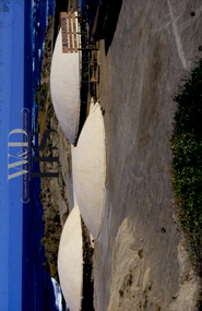
The Warrnambool aquarium was opened in 1971 and was mostly underground with three domes above ground level. It is situated near the Warrnambool breakwater and the main structure is still extant. It closed as an aquarium in 1990 and was then used by Deakin University as a research centre for a few years. The aquarium contained exhibits of marine life and shells. This slide is retained as a reminder of the Warrnambool aquarium, an important tourist attraction for over twenty years.This slide in a cardboard frame is a multi- coloured one of the Warranmbool aquarium showing the three domes and the coastline in the background. There is a wooden sign, a fence and the road in the foreground. AQUARIUM COOKED/ LIVE CRAYS SOUVENIRS BAIT MUSEUM KIOSK DOWNSTAIRS warrnambool, warrnambool aquarium -
 Warrnambool and District Historical Society Inc.
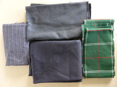
Textile, Fletcher Jones, late 20th century
These are samples of the material used at the Fletcher Jones Factory in Warrnambool to make garments for men (suits, trousers, shorts) and women (suits, slacks, skirts, shorts). Fletcher Jones Clothing Factory was a key industry in Warrnambool from 1948 to its closure in 2005. The business was founded by David Fletcher Jones (1897-1977), a clothing manufacturer and retailer who worked as a hawker in the Western District following service with the A.I.F. in World War One. In 1924 Fletcher Jones opened three shops in Liebig Street selling men’s wear, hosiery and linen and operating a small tailoring business. He moved his shop to another location in Liebig Street and began to concentrate on men’s trousers production. In 1946 he opened a shop in Collins Street in Melbourne and eventually had stores and factories all over Australia. In Warrnambool he opened his factory at Pleasant Hill in Flaxman Street in 1948 and became a major Warrnambool employer, with over 1000 employees at one time. He transformed his business into a co-operative, with the name, ‘Fletcher Jones and Staff’ registered in 1947. The business diversified into other ranges of clothing for men and women but failed to compete with cheaper overseas clothing imports and the factory and shops were closed in the early 21st century. These pieces of material are of some interest as examples of the materials used in one of the most important businesses in Warrnambool and one that was of national significance for many decades. The Fletcher Jones label was well-known throughout Australia and Fletcher Jones himself was a prominent person in Warrnambool’s history, not only for his business interests but also for his philanthropy, his advocacy of business co-operatives and his support for many Warrnambool institutions. The Fletcher Jones Factory Gardens are still today a feature of Warrnambool and a tourist attraction. These two packets contain samples of materials used at the Fletcher Jones factory in Warrnambool. One packet (VC000690.1) contains four pieces of woollen material, one grey striped, one grey weave, one navy and one green, red and white tartan. The other packet (VC000690.2) contains two pieces of woollen grey and navy material and five small woollen samples of dark grey, light grey, navy, beige and blue and grey check material. warrnambool, industry -
 Warrnambool and District Historical Society Inc.
Leaflet, Motorists and Tourists
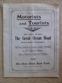
This leaflet published by The Great Ocean Road Trust in 1918 gives information about the proposed building of the Great Ocean Road from Barwon Heads to Warrnambool as a memorial to Victorian soldiers in World War One. The President of the Trust, which was a private company seeking donations from the public, was Howard Hitchcock, the Mayor of Geelong. The Memorial Great Ocean Road commenced in 1919 with 3000 ex-servicemen employed to build the road. In 1932 the road was completed to Apollo Bay and in 1936 the road was officially handed into the care of the State Government. This leaflet is of some significance as it shows the initial efforts by Howard Hitchcock of Geelong and a private trust to build the Great Ocean Road in Victoria. This road is today of international significance This is an unbound leaflet of 8 pages (almost A4 size) folded into two insert pages. It has 10 photographs of views along the Great Ocean Road and typed information on the Great Ocean Road Trust and its Building Appeal. It was produced in 1918.great ocean road, great ocean road trust 1918, warrnambool history, memorial great ocean road -
 Warrnambool and District Historical Society Inc.
Souvenir Mug, A present from Warrnambool, Early 20th century
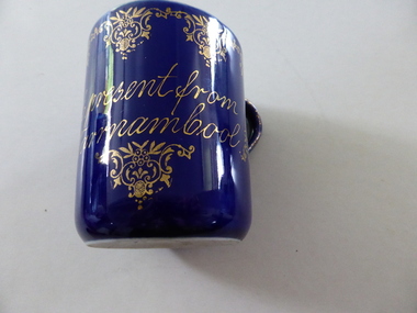
This cup is an impressive souvenir of a visit to Warrnambool. Tourism in Warrnambool became important in the late 19th century with Warrnambool promoted as a spa resort. ( Coast line,sea baths etc). Today tourism is important in both summer and Winter (May Racing Carnival and whales). A object with which people, especially tourists, would identify.Straight sided glazed royal blue cup with gold text and decoration.Glazed white interior.A present from Warrnambool written on side of the mug. Made in Germany stamped in red on bottom of mug. Numbered 13 warrnambool -
 Warrnambool and District Historical Society Inc.
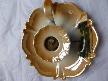
Plate, Mouth of the Hopkins, c.1920
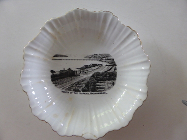
This is a dish made by the English company of Royal Stafford Bone China about 1920 and sold in Warrnambool as a souvenir of the city with an image of the scene at the mouth of the Hopkins River. The scene depicted shows the old Hopkins Hotel, Proudfoots Boathouse, Lyndoch and the Hopkins River Bridge. This dish is of some interest as an example of the type of high quality souvenir offered to local tourists in the early 20th century. It is historically interesting as it depicts the Hopkins River mouth about 1920 and there have been many changes since then.This is a white oval dish with fluting on the sides and fluted edges. The rim of the fluting is outlined in gold. On the inside base of the dish is a black and white image of the mouth of the Hopkins River. There are brown stains on part of the fluted material and the outside base has the maker’s shield and name. There is a small crack on the edge of the dish.‘Guaranteed Royal Stafford English Bone China Made in England.’ history of warrnambool -
 Warrnambool and District Historical Society Inc.
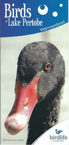
Document, Pamphlets lake Pertobe, 2014
Lake Pertobe in Warrnambool is a former swamp area which was transformed into a recreational area and children’s playground in the 1970s. The reserve is a popular spot for bird watching with over 80 species found in the vicinity. The brochure on Lake Pertobe’s birds had been produced by BirdLife Warrnambool, part of BirdLife Australia, an independent, not-for profit organisation aiming to protect our birdlife and disseminate information on Australian birds. This is an important little brochure as it contains information for locals and tourists about the birdlife in Lake Pertobe, one of the best-known and best-loved spots in WarrnamboolThis is an A3 sheet of paper printed on both sides and folded three times to form a brochure. It contains colour photographs of birds, two maps and information about BirdLife Warrnambool and BirdLife Australia and the logo of Birdlife Warrnambool.Front Cover: ‘Birds of Lake Pertobe, Warrnambool, BirdLife Warrnambool, Birds are in our nature’ lake pertobe, birdlife warrnambool, warrnambool -
 Warrnambool and District Historical Society Inc.
Candle Holder, 1930s
This is a china candle holder which is a souvenir of Warrnambool with an image on the item of the Warrnambool War Memorial. Czechoslovakia was established as a country in 1918 and began to export china goods in the 1920s and 30s when the label ‘Victoria China’ became well known. The Warrnambool War Memorial at the southern end of Liebig Street was unveiled and dedicated in 1926. It was designed by John King, the Headmaster of the Warrnambool Technical School and erected by the local stonemasons, Wooles and Carpenter. This candle holder is of some interest as an example of the tourist souvenirs that were popular in Warrnambool pre-World War Two. This is a china candle holder with a circular base in brown-orange and white tonings and a fluted edge. The candle holding section is also circular with the same colour tonings and a slightly fluted edge. Inside this are the hardened remains of a candle. The base has a handle attached. On one edge of the base there is a colour image of the Warrnambool War Memorial. The maker’s name at the back has a crown symbol. ‘Soldier’s (sic) Memorial, Warrnambool’ ‘Victoria China, Czechoslovakia’ victoria china czechoslovakia, warrnambool war memorial, history of warrnambool -
 Warrnambool and District Historical Society Inc.
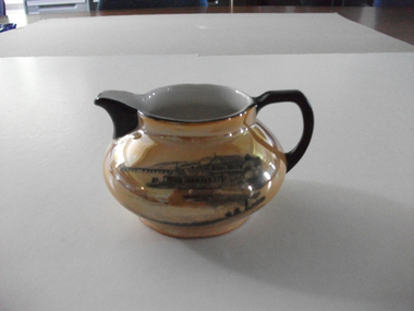
Jug, Souvenir Warrnambool Jug, Between 1921 and 1938
This is a souvenir jug showing an image of the boat sheds (Proudfoots) at the mouth of the Hopkins River, Warrnambool. It would have been purchased in the 1920s or 1930s. These boatsheds were erected for Thomas Proudfoot in 1885. At that time the sheds housed the boats of the local Gordon Rowing Club. This jug is of interest as an example of the type of souvenir available to tourists and locals in the Warrnambool district in the 1920s and 30s. This is a lustre ware china jug with a black handle and a black lip and black edging around the opening. The jug has a squat spherical shape and has gold colouring with an image in black and grey of the boatsheds at the mouth of the Hopkins River, Warrnambool. The lettering is in black and on the base are the maker’s symbols. ‘Boat Houses on the Hopkins, Warrnambool ’23 R.K.G. Made in Cechoslov (sic)’ proudfoots boatsheds. warrnambool, hopkins river, warrnambool, history of warrnambool -
 Kiewa Valley Historical Society
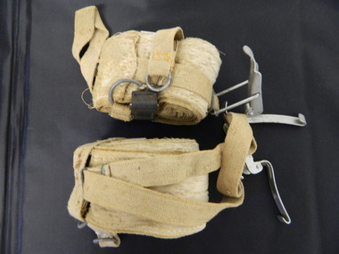
Ski Skins - Pair
Ski skins and webbing were introduced into the Victorian Alps by European skiers. Enthusiasts travelled to enjoy the snow and to explore the Victorian Alps including the Bogong High Plains. This equipment enabled them to travel over snow without slipping when going up hills. They took the skins off when they wanted to slide down hills. In later years waxes were used for cross country skiing and then 'fish tail' markings on the back of skis to enable skiers to travel distances up and down mountains. Later developments also included motor transport (replacing horses to get to the snow line) and roads to take skiers to the ski fields and mechanised tows to take skiers up mountains so they could ski down (downhill skiing).Skiers visited the Bogong High Plains especially during the years of the State Electricity Commission of Victoria's construction of the Kiewa Hydro Electric Scheme from the 1930's onwards. Tourists to the area increased during this time and influenced the development of Falls Creek.Long cream strips with soft short 'fur' on one side and a type of strong hessian on the back with the length of the middle and sides stitched. At one end an adjustable strap is attached to a steel, hinged clasp and at the other end is a loop that fits over the ski. A quarter of the way from each end is a steel attachment for fastening over the ski - the 'toe' end with a rubber embossed flap and the other with a short and long strap each with a steel ring at the end.On the rubber attachment: 'vinersa/pat uno'ski skins; bogong high plains; falls creek -
 Kiewa Valley Historical Society
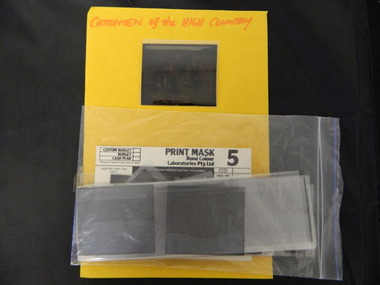
Photo Negatives of Cattlemen of the Bogong High Plains
Photos taken by a professional photographer on the Bogong High Plains.Photos were printed as post cards and sold to tourists.45 colored negatives of Cattlemen of the Bogong High Plains. In plastic strips in a plastic pocket and in a yellow envelope.On envelope: "Cattlemen of the High Country"cattlemen; bogong high plains; professional photographer -
 Kiewa Valley Historical Society
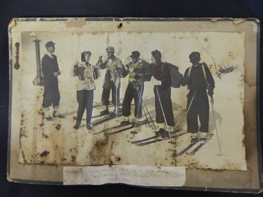
Photo - Skiers 1946, August 1946
During winter skiers skied on the Bogong High Plains. During the 1940's the State Electricity Commission of Victoria was constructing the Kiewa Hydro Electric Scheme and skiing was part of their employees recreation. Skippy St Elmo won ski races during the 1940's practising on the High Plains where she and her husband lived. Her husband worked for the S.E.C.V..Employees of the State Electricity Commission of Victoria were early skiers on the Bogong High Plains. The area is a well known tourist centre for skiers, bush walkers and bike riders.Black and cream photo glued onto thick cardboard with a label glued on at the bottom.L to R Wally Baldwin, Joyce Fisher, Dick Moore, / Chas Armada, Skippy St Elmo, Toni St Elmo / August 1946snow skiers; bogong high plains; state electricity commission of victoria; kiewa hydro electric scheme; skippy st elmo -
 Kiewa Valley Historical Society
Photo - Bogong Township, March 1944
In 1940 Field Headquarters for the Kiewa Scheme were established at Bogong with office, workshop facilities and accommodation for workmen, staff and some families constructed. (There had been a 'tent camp' on this site in 1939 but was destroyed by bushfires) Construction of accommodation continued until 1947. A total of 40 houses plus a hostel for single staff, post office, police station, medical centre and primary school all with water and sewerage and electricity supply. The staff hostel was known as Kiewa House and is now occupied by the Education Department. Lake Guy was named after Mr. L.T. Guy who was the Resident Engineer in charge of construction work and associated activities on the Kiewa area. He held this position from 1939 to November 1946 when he was transferred to Head Office. The Bogong Township was developed firstly as an accommodation centre (base camp) for construction workers employed under the Kiewa Hydroelectric Scheme. Due to the influx of European workers into the Township the beautification of the immediate surrounds (gardens etc.) had a distinct European flavour. This environment has been very beneficial for tourism in later years. At the completion of the scheme, in the 1960's, the village was opened to public/tourism use. Strict environmental control has not allowed for any extensive redevelopment in tourist accommodation and basically restricted it to the accommodation initially built for the construction workers. Activities such a bike riding, snow skiing, restricted horse riding and bush walking on the Alpine plains and mountains are now a viable part of the Kiewa Valley Tourist Industry. The lake is one of the many water storage reservoirs used to supply the power stations their main power to run the huge turbines generating the final product, electricityBlack and white photograph of Bogong Township taken March 1944Handwritten on the back of photo - Township March '44bogong village, secv -
 Kiewa Valley Historical Society
Photograph - Bogong Village (7 copies), Approx 1940
In 1940 Field Headquarters for the Kiewa Scheme were established at Bogong with office, workshop facilities and accommodation for workmen, staff and some families constructed. (There had been a 'tent camp' on this site in 1939 but was destroyed by bushfires) Construction of accommodation continued until 1947. A total of 40 houses plus a hostel for single staff, post office, police station, medical centre and primary school all with water and sewerage and electricity supply. The staff hostel was known as Kiewa House and is now occupied by the Education Department. Lake Guy was named after Mr. L.T. Guy who was the Resident Engineer in charge of construction work and associated activities on the Kiewa area. He held this position from 1939 to November 1946 when he was transferred to Head Office. The Bogong Township was developed firstly as an accommodation centre (base camp) for construction workers employed under the Kiewa Hydroelectric Scheme. Due to the influx of European workers into the Township the beautification of the immediate surrounds (gardens etc.) had a distinct European flavour. This environment has been very beneficial for tourism in later years. At the completion of the scheme, in the 1960's, the village was opened to public/tourism use. Strict environmental control has not allowed for any extensive redevelopment in tourist accommodation and basically restricted it to the accommodation initially built for the construction workers. Activities such a bike riding, snow skiing, restricted horse riding and bush walking on the Alpine plains and mountains are now a viable part of the Kiewa Valley Tourist Industry. The lake is one of the many water storage reservoirs used to supply the power stations their main power to run the huge turbines generating the final product, electricity. Evidence can be seen of the 1939 bushfires.Set of 7 identical black and white photographs of Bogong Village after 1939 bush firesHandwritten on the back of one photo - Bogong Village approx. 1940, after 1939 bush fires. Staff residences to left. Kiewa House, General offices and test lab to the right. Hand drawn map on the back of one photo.bogong village, secv -
 Kiewa Valley Historical Society
Photo - Bogong Village Township, October 8, 1946
In 1940 Field Headquarters for the Kiewa Scheme were established at Bogong with office, workshop facilities and accommodation for workmen, staff and some families constructed. (There had been a 'tent camp' on this site in 1939 but was destroyed by bushfires) Construction of accommodation continued until 1947. A total of 40 houses plus a hostel for single staff, post office, police station, medical centre and primary school all with water and sewerage and electricity supply. The staff hostel was known as Kiewa House and is now occupied by the Education Department. Lake Guy was named after Mr. L.T. Guy who was the Resident Engineer in charge of construction work and associated activities on the Kiewa area. He held this position from 1939 to November 1946 when he was transferred to Head Office. The Bogong Township was developed firstly as an accommodation centre (base camp) for construction workers employed under the Kiewa Hydroelectric Scheme. Due to the influx of European workers into the Township the beautification of the immediate surrounds (gardens etc.) had a distinct European flavour. This environment has been very beneficial for tourism in later years. At the completion of the scheme, in the 1960's, the village was opened to public/tourism use. Strict environmental control has not allowed for any extensive redevelopment in tourist accommodation and basically restricted it to the accommodation initially built for the construction workers. Activities such a bike riding, snow skiing, restricted horse riding and bush walking on the Alpine plains and mountains are now a viable part of the Kiewa Valley Tourist Industry. The lake is one of the many water storage reservoirs used to supply the power stations their main power to run the huge turbines generating the final product, electricityBlack and white photograph of Bogong Village which appeared in the Herald Sun newspaper on October 8, 1946. Page 13Handwritten on the back - Town of Bogong on a rugged mountain slope above Lake Guy. State Electricity Committee workers on the Kiewa Hydro Electric scheme live here in all electric homes. Stamped on the back - Copyright Not for reproduction Herald Sun Feature Service Melbourne Australiabogong village; lake guy; kiewa hydro electric scheme -
 Kiewa Valley Historical Society
Postcard - Lake Guy and Bogong Village
In 1940 Field Headquarters for the Kiewa Scheme were established at Bogong with office, workshop facilities and accommodation for workmen, staff and some families constructed. (There had been a 'tent camp' on this site in 1939 but was destroyed by bushfires) Construction of accommodation continued until 1947. A total of 40 houses plus a hostel for single staff, post office, police station, medical centre and primary school all with water and sewerage and electricity supply. The staff hostel was known as Kiewa House and is now occupied by the Education Department. Lake Guy was named after Mr. L.T. Guy who was the Resident Engineer in charge of construction work and associated activities on the Kiewa area. He held this position from 1939 to November 1946 when he was transferred to Head Office. The Bogong Township was developed firstly as an accommodation centre (base camp) for construction workers employed under the Kiewa Hydroelectric Scheme. Due to the influx of European workers into the Township the beautification of the immediate surrounds (gardens etc.) had a distinct European flavour. This environment has been very beneficial for tourism in later years. At the completion of the scheme, in the 1960's, the village was opened to public/tourism use. Strict environmental control has not allowed for any extensive redevelopment in tourist accommodation and basically restricted it to the accommodation initially built for the construction workers. Activities such a bike riding, snow skiing, restricted horse riding and bush walking on the Alpine plains and mountains are now a viable part of the Kiewa Valley Tourist Industry. The lake is one of the many water storage reservoirs used to supply the power stations their main power to run the huge turbines generating the final product, electricityBlack and white photographic postcard of Lake Guy and Bogong Village. Kiewa Hydro electric Project (showing Junction Dam in front)Handwritten on the back of postcard ' Like most of our camps, this looks like something from the Canadian Rockies' Stamped on the back - Valentine's Post Card A genuine photographlake guy, bogong village, secv -
 Kiewa Valley Historical Society
Photo - Bogong Township, September 1953
In 1940 Field Headquarters for the Kiewa Scheme were established at Bogong with office, workshop facilities and accommodation for workmen, staff and some families constructed. (There had been a 'tent camp' on this site in 1939 but was destroyed by bushfires) Construction of accommodation continued until 1947. A total of 40 houses plus a hostel for single staff, post office, police station, medical centre and primary school all with water and sewerage and electricity supply. The staff hostel was known as Kiewa House and is now occupied by the Education Department. Lake Guy was named after Mr. L.T. Guy who was the Resident Engineer in charge of construction work and associated activities on the Kiewa area. He held this position from 1939 to November 1946 when he was transferred to Head Office. The Bogong Township was developed firstly as an accommodation centre (base camp) for construction workers employed under the Kiewa Hydroelectric Scheme. Due to the influx of European workers into the Township the beautification of the immediate surrounds (gardens etc.) had a distinct European flavour. This environment has been very beneficial for tourism in later years. At the completion of the scheme, in the 1960's, the village was opened to public/tourism use. Strict environmental control has not allowed for any extensive redevelopment in tourist accommodation and basically restricted it to the accommodation initially built for the construction workers. Activities such a bike riding, snow skiing, restricted horse riding and bush walking on the Alpine plains and mountains are now a viable part of the Kiewa Valley Tourist Industry. The lake is one of the many water storage reservoirs used to supply the power stations their main power to run the huge turbines generating the final product, electricityBlack and white photograph of Bogong Township taken from Little Arthur fire track. September 1953Faded handwritten inscription on back - Bogong Township taken from Little Arthur fire track. Sept 1953bogong village, secv -
 Kiewa Valley Historical Society
Photo - First Bogong Camp, September 1950
In 1940 Field Headquarters for the Kiewa Scheme were established at Bogong with office, workshop facilities and accommodation for workmen, staff and some families constructed. (There had been a 'tent camp' on this site in 1939 but was destroyed by bushfires) Construction of accommodation continued until 1947. A total of 40 houses plus a hostel for single staff, post office, police station, medical centre and primary school all with water and sewerage and electricity supply. The staff hostel was known as Kiewa House and is now occupied by the Education Department. Lake Guy was named after Mr. L.T. Guy who was the Resident Engineer in charge of construction work and associated activities on the Kiewa area. He held this position from 1939 to November 1946 when he was transferred to Head Office. The Bogong Township was developed firstly as an accommodation centre (base camp) for construction workers employed under the Kiewa Hydroelectric Scheme. Due to the influx of European workers into the Township the beautification of the immediate surrounds (gardens etc.) had a distinct European flavour. This environment has been very beneficial for tourism in later years. At the completion of the scheme, in the 1960's, the village was opened to public/tourism use. Strict environmental control has not allowed for any extensive redevelopment in tourist accommodation and basically restricted it to the accommodation initially built for the construction workers. Activities such a bike riding, snow skiing, restricted horse riding and bush walking on the Alpine plains and mountains are now a viable part of the Kiewa Valley Tourist Industry. The lake is one of the many water storage reservoirs used to supply the power stations their main power to run the huge turbines generating the final product, electricityBlack and white photo of Bogong Village. September 1950Handwritten on the back - 1st Bogong Camp. SEC Kiewa Scheme Sept 1950bogong camp, bogong village, secv -
 Kiewa Valley Historical Society
Photo - Bogong Village Township
In 1940 Field Headquarters for the Kiewa Scheme were established at Bogong with office, workshop facilities and accommodation for workmen, staff and some families constructed. (There had been a 'tent camp' on this site in 1939 but was destroyed by bushfires) Construction of accommodation continued until 1947. A total of 40 houses plus a hostel for single staff, post office, police station, medical centre and primary school all with water and sewerage and electricity supply. The staff hostel was known as Kiewa House and is now occupied by the Education Department. Lake Guy was named after Mr. L.T. Guy who was the Resident Engineer in charge of construction work and associated activities on the Kiewa area. He held this position from 1939 to November 1946 when he was transferred to Head Office. The Bogong Township was developed firstly as an accommodation centre (base camp) for construction workers employed under the Kiewa Hydroelectric Scheme. Due to the influx of European workers into the Township the beautification of the immediate surrounds (gardens etc.) had a distinct European flavour. This environment has been very beneficial for tourism in later years. At the completion of the scheme, in the 1960's, the village was opened to public/tourism use. Strict environmental control has not allowed for any extensive redevelopment in tourist accommodation and basically restricted it to the accommodation initially built for the construction workers. Activities such a bike riding, snow skiing, restricted horse riding and bush walking on the Alpine plains and mountains are now a viable part of the Kiewa Valley Tourist Industry. The lake is one of the many water storage reservoirs used to supply the power stations their main power to run the huge turbines generating the final product, electricityBlack and white photograph of Bogong Village from across Lake Guy. Photo mounted on buff cardbogong village, secv -
 Kiewa Valley Historical Society
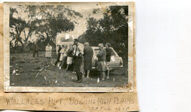
Photographs x 2- Bus tour of Wallaces Hut, 20/02/1970
Wallace's hut was built in 1889 and is probably the oldest surviving hut on the high plains of north-east Victoria. It was built in six weeks by Irish immigrant brothers Arthur, William and Stewart Wallace among old snow gums on a grassy plain above the snowline. The brothers held grazing leases on the High Plains and the hut was built to provide shelter for the cattlemen working there. It is probably the oldest hut on the Victorian high plains. It is part of the early history of hydroelectricity in the state and has links with early SEC meteorological data recording in the area Apart from its historical significance, Wallace’s Hut is a popular stop for tourists and photographers and is the starting point for the Wallace’s Heritage trail, which is a popular and well used hiking track, by locals and visitors alike.2 black and white photographs mounted on buff card. Photos taken during a bus trip to Wallace's Hut on Feb. 20, 1970 1. Group of local Kiewa Valley residents on a bus tour to Wallace's hut 2. Group of adults and children pictured outside Wallace's hut1. Handwritten in black ink on bottom of photo 'Wallace's Hut, Bogong High Plains, 20 Feb, 1970 2. No markingswallace's hut, bogong high plains, bush walking, cattlemen -
 Kiewa Valley Historical Society
Photographs x 2 1. Lake Guy & Bogong Village 2. Bulldozer moving rocks
1. In 1940 Field Headquarters for the Kiewa Scheme were established at Bogong with office, workshop facilities and accommodation for workmen, staff and some families constructed. (There had been a 'tent camp' on this site in 1939 but was destroyed by bushfires) Construction of accommodation continued until 1947. A total of 40 houses plus a hostel for single staff, post office, police station, medical centre and primary school all with water and sewerage and electricity supply. The staff hostel was known as Kiewa House and is now occupied by the Education Department. Lake Guy was named after Mr. L.T. Guy who was the Resident Engineer in charge of construction work and associated activities on the Kiewa area. He held this position from 1939 to November 1946 when he was transferred to Head Office. 2. Example of the type of heavy machinery used in clearing and building of Lake Guy, Bogong Village and Clover Dam 1. The Bogong Township was developed firstly as an accommodation centre (base camp) for construction workers employed under the Kiewa Hydroelectric Scheme. At the completion of the scheme, in the 1960's, the village was opened to public/tourism use. Strict environmental control has not allowed for any extensive redevelopment in tourist accommodation and basically restricted it to the accommodation initially built for the construction workers. Lake Guy is one of the many water storage reservoirs used to supply the power stations their main power to run the huge turbines generating the final product, electricity 2. Pictorial record of the types of machinery used in the development of Bogong Village and the Hydro-electricity scheme including the Clover Dam. Note the lack of safety equipment worn by construction workers of the period. 2 black and white photographs taken at Bogong 1. Lake Guy with Bogong Village in the background 2. Workman in bulldozer clearing rocks, possibly for construction at Bogong1. Handwritten in blue ink on back of photo 'Lake Guy showing Bogong Village' 2. No markingslake guy, bogong village, secv -
 Kiewa Valley Historical Society
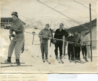
Photographs – Skiers at Falls Creek – Set of 10 black and white photographs
After World War II, the Kiewa Hydro-Electric Scheme was started in the Kiewa River valley by the State Electricity Commission of Victoria. On land previously used only for summer cattle grazing in the natural alpine grasslands, the first ski lodge was built in 1948 by workers from the hydro scheme as skiing was a popular recreation. Many of the hydro employees were of European background and had grown up enjoying skiing and snow sports in their homelands and were keen to continue to pursue their winter sports interests. The first lift, a rope tow, was built in 1951 and the first chairlift in Australia was constructed there in 1957. Two T-Bars were opened in 1961. In 1964, the Victorian Municipal Directory recorded that Falls Creek had 29 ski club lodges and 16 commercial lodges.Employees of the State Electricity Commission of Victoria in the Kiewa River Valley were the earliest skiers on the Bogong High Plains and built one of the first ski lodges at Falls Creek. They were amongst those pivotal in the development of the skiing and tourist industry at Falls Creek and on the Bogong High Plains. Set of 10 black and white photographs of various skiers at Falls Creek Victoria1. From Left-John Robertson Myrtleford; Bill Bridgford, St Trinians; Girl not known; Roy Wolpole, Myrtleford; Fin McAuliffe, Myrtleford; Looking on foreground, Toni St Elmo 2. Falls Creek. Property of State Electricity Commission of Victoria Publicity Photo Negative No PB4046. Publicity Branch, 15 William St Melbourne. 3. Avic Lajons 4. No markings 5. Bill Bridgeford (lower person on slope) 6. Max Lawrence? Facing skiers 7. 6575. Indistinguishable red stamp on back 8. 6875. Ces Dobson on tractor 9. From left on tow. John Robertson (Myrtleford); Bill Bridgeford (St Trinians); Girl unknown; Roy Walpole (Myrtleford); Vin McAuliffe (Myrtleford); Looking on foreground Toni Beveridge. 10. From Left 1; 2; 3. Bill Bridgeford; 4. George McPherson ? (Myrtleford); 5. John Robertson (Myrtleford); 6. Elsbeth Rollenson? (Myrtleford); 7; 8; 9. 11. Bogong. Looking N.E from Big River fire track. Skiers on way to Falls Creek. Spion Kop on left. Going around Ropers Cerner near the 18 mile post falls creek, skiing, bogong high plains -
 Kiewa Valley Historical Society
Newspaper article- Double page article. Pages 30 & 83 from the Herald Sun Newspaper. February 18, 2006 regarding preserving Victoria’s High Country Huts
The arrival of explorers Hume & Hovell in 1842 brought about the widespread clearing of land in the valleys for pastoral uses and the displacement the original inhabitants in the high country which became a boon for cattlemen due to extensive lush summer grazing for cattle. High country cattlemen built a variety of huts for shelter and storage, when driving cattle up to the plains in summer, during mustering and bringing the cattle down from the mountains before winter closed in. These same huts now provide shelter from the elements for hikers, bush walkers and skiers. Wallace’s Hut is the oldest of the Cattleman’s huts still standing in the Alpine National Park and is classified under the National Trust. Due to their age and the ravages of the elements, including bush fires, many of the huts have been destroyed, or are falling into disrepair. Groups of willing volunteers are now working to preserve as many of the huts as possible with restoration or rebuilding.The numerous cattleman’s huts of the Alpine National Park and the colourful characters who erected them represent a significant part of the history of the high country area and early cattle grazing, which has been the theme for many poets and film-makers alike. They also have a significant role in the early days of the SECV when they were used by surveyors and other workers for shelter and temporary accommodation. More recently the huts have functioned as shelter for hikers and skiers caught out in the elements and a refuge along the long trek for bush walkers. They are a popular attraction for tourists and feature prominently in much of the tourist information of the region. Black and white double page Newspaper article from the Herald Sun Newspaper of February 18, 2006 regarding the efforts of Mr David Oldfield to preserve Victoria’s remaining High Country Huts through his photography and efforts to restore old and Re-build missing ones. Article shows a photograph of David Oldfield and some of his photographic work of the huts. Page number and date printed at top of each page 30 Herald Sun, Saturday, February 18, 2006 Herald Sun, Saturday, February 18, 2006 83 cattlemen's huts; david oldfield; bogong high plains; wallace's hut; high country; alpine national park -
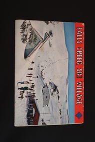 Kiewa Valley Historical Society
Souvenir Postcard Folder – Falls Creek Ski Village
Falls Creek Ski Resort developed during the construction of the Kiewa Hydro Electric Scheme built by the State Electricity Commission of Victoria. The first ski lodge was built in 1948 by workers from the scheme. The first lift, a rope tow, was built in 1951 and the first chairlift in Australia was constructed there in 1957. Falls Creek Post Office opened in 1958. Tourism was growing and being encouraged by local businesses.The souvenir postcard was produced by Mr S. K. Pearce a Mt Beauty businessman. It was a memento for skiers and visitors to the Falls Creek and Mt Beauty area to send to family and friends as a reminder of their visit to the region or to keep as a personal souvenir. It presented an excellent promotional opportunity for enterprising local businessmen to promote the area to skiers and tourists near and far. It also presents an excellent pictorial history of the Falls Creek area around the late 1950's and 1960's.Colour postcard folder (unused) containing 12 labelled colored photos of the Falls Creek ski area and surrounds with a blank 'page' entitled 'Correspondence' and another for the address.falls creek, skiing, snow sports, s. k. pearce, tourism, secv -
 Kiewa Valley Historical Society
Photograph – Set of 3 black and white photographs of Bogong Village circa late 1930's - 1940's during early construction of Lake Guy ( in the foreground), Late 1930's - 1940's
In 1940 Field Headquarters for the Kiewa Scheme were established at Bogong with office, workshop facilities and accommodation for workmen, staff and some families constructed. (There had been a 'tent camp' on this site in 1939 but was destroyed by bush fires) Construction of accommodation continued until 1947. A total of 40 houses plus a hostel for single staff, post office, police station, medical centre and primary school all with water and sewerage and electricity supply. The staff hostel was known as Kiewa House and is now occupied by the Education Department. Lake Guy was named after Mr. L.T. Guy who was the Resident Engineer in charge of construction work and associated activities on the Kiewa area. He held this position from 1939 to November 1946 when he was transferred to Head Office. The Bogong Township was developed firstly as an accommodation centre (base camp) for construction workers employed under the Kiewa Hydroelectric Scheme. Due to the influx of European workers into the Township the beautification of the immediate surrounds (gardens etc.) had a distinct European flavour. This environment has been very beneficial for tourism in later years. At the completion of the scheme, in the 1960's, the village was opened to public/tourism use. Strict environmental control has not allowed for any extensive redevelopment in tourist accommodation and basically restricted it to the accommodation initially built for the construction workers. Activities such a bike riding, snow skiing, restricted horse riding and bush walking on the Alpine plains and mountains are now a viable part of the Kiewa Valley Tourist Industry. The lake is one of the many water storage reservoirs used to supply the power stations their main power to run the huge turbines generating the final product, electricity3 black and white photographs of the Bogong camp area showing the clearing of trees for the construction of the Junction Dam and Lake Guy. Some administration buildings have been constructed, but part of the tent camp can be seen to the right of the photograph in front of the buildings. bogong village; junction dam; lake guy; kiewa hydro electric scheme; secv -
 Kiewa Valley Historical Society
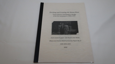
Book - Kiewa River, Stocking and Crossing the Kiewa River by Jan Hunter (nee Chick), 2020
The Chick brothers, Alf, Les and Allan, plus friends, began trout fishing and camping in the Kiewa Valley before the early 1930s. Les continued his connection with the Kiewa River until his death in 1972. Fingerlings were placed in the Kiewa River from the early 1880s. Keegan's Bridge is a crossing near Upper Gundowring and about 4 km south east of Dederang. References to the crossing were made in the early 1900s and a petition presented to Council in 1904 calling for a bridge.The bridge was built and opened in 1907. The photos are of the release of fingerling trout in the Kiewa River, thought to be at Keegan's Bridge. The fingerlings were transported in drums on the back of trucks. The photos are c1940s.The Kiewa Valley has been a popular spot for fishermen, tourists and campers from the 1880s. One of the many attractions has been the excellent fishing along the Kiewa River due to the regular release of fish especially brown trout. This continues to the present day (2020) when a few fish were marked with $$ signs for the lucky fisherman who caught them. This attracts visitors, their families and boosts the economy and dates back to visits at the Tawonga Pub prior to the Kiewa Hydro Electric Scheme.19 page book with black plastic spine and clear plastic cover over the beige paper cover with title , author and black & white photo. Note: In KVHS photo collection there are 4 good quality reproduction photos on photographic paper. These have been produced professionally. These photos of Jan Hunter's are featured on the second page of her book. These also have a letter attached. The book is a pre-research paper & is No 33 of the Albury and District Historical Society Papers. The sub-title is "Trout releases and Keegan's Bridge / from the newpapers, 1882-1935"None on the book but a letter is attached from Jan Hunter, the author as a follow up to the photos she donated. On the photos - On the back: Fujifilm / Fujicolor Crystal Archive / Paper / Production - run codekiewa river; trout; fish; keegan's crossing; keegan's bridge; fingerlings; chick family; camping; tourism -
 Kiewa Valley Historical Society
Calendar 2008
Brief history of the SECV construction town of Bogong which became a tourist town."Memories of Bogong Calendar 2008" Photographs of the physical environment. Front cover has a photograph of a person standing in a river. A short history of 'Bogong 1957-1963' and 'Come visit Bogong Village' a 'celebration of Bogong Village's environment'. 12pp with a hole (to hang up) in the centre bottombogong, calendar, tourism, bogong village, secv, kiewa hydro electric scheme -
 Kiewa Valley Historical Society
Photo Collection - Wally Howell, Falls Creek and Kiewa Hydro Electric Scheme including Mt Beauty
1. Falls Creek ski resort is on the Bogong High Plains 2. Kiewa Hydro Electric Scheme (late 1940s to early 1960s) was constructed by the State Electricity Commission of Victoria and included the townships of Bogong and Mt Beauty. The photos were taken by Wally Howell.Falls Creek is at the head of the Kiewa Valley and a major tourist attraction. Kiewa Hydro Electric Scheme was constructed by the SECV and included the creation of the Mt Beauty township.1. 16 Coloured photos of Falls Creek - not dated or labelled. Includes Malony's Ski Hire & Restaurant and Sundance Inn 2. 162 Coloured Photos not dated or labelled. Includes Kiewa Hydro Electric Scheme and Mt Beauty. Some multiple copies. 1. "Processed by Kodak Oct. 85 M" on printed in red ink on the back of one photo. Also, later labels were added in ink to identify each photo.falls creek, snow resort, skiing, ski lodges, sundance inn, malony's ski hire, spargos lodge, t-bar lifts, mt beauty, tourism