Showing 214 items
matching church avenue
-
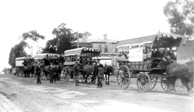
 Ballarat Tramway Museum
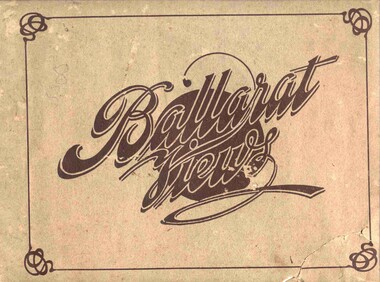
Book, Baxter & Stubbs, "Ballarat Views", 1920's
Yields information about Ballarat through pictures of the 1910-1920's various locations, institutions and street scenes, including tramways and railways.Twenty four page book within light brown covers, titled "Ballarat Views". Sheets, other than covers have been individually printed both sides, stapled within the covers. Cover - gives title, rear cover has printer details - Baxter and Stubbs. Pages 1 - Tonner Memorial , Fountain Lake Wendouree, Ballarat District Hospital, Sturt St south side at Grenville St with tram in distance and Sturt St North Side showing shops (image btm3900i2.jpg). 2 - Ballarat Street Scenes - Sturt Streets, Lydiard St with ESCo 18 in view, and Railway station with R193 in platform on passenger train. (image btm3900i3.jpg). 3 - Lake Wendouree views. 4 - Lake Wendouree, fish hatchery, Gardens and Sturt St at Dawson St (image btm3900i4.jpg). 5 - Art Gallery Ballarat 6 - Botanical Gardens 7 - Public Institution s- Benevolent asylum, Orphanage, Nazareth House, St Joseph Home, Hospital 8 & 9 - Statues, the Flight from Pompeii and others. 10 & 11 - Churches of Ballarat 12 - The Arch at The Avenue of Honour 13 - McDonald Pergola at the Gardens 14 - Zoological Gardens Ballarat 15 - Gardens aerial view and gates at the South End with tram in the distance (image btm3900i5.jpg). 16 - Some views in Ballarat East - Eureka Stockade, Ballarat East Bowling Green, Bridge St looking east and the lake at the Eureka Gardens (image btm3900i6.jpg). 17 - Snow Scene at Botanical Gardens, Begonia House 18 & 19 - Ballarat Water supply reservoirs 20 - Ballarat State Schools 21 - Ballarat East Views, includes view of track in Victoria St looking east (image btm3900i7.jpg). 22 - Views of the Water Reserves 23 - Views about the City - includes City fire station , agricultural High School, City Baths and View Point. 24 - Views at Lake Wendouree. \ Pdf copy of full book added 8/5/2019 - see btm3900i9.pdf trams, tramways, ballarat, lydiard st, sturt st, gardens, railway station, hospital, lake wendouree, wendouree parade, carlton st, esco -
 Ballarat Tramway Museum
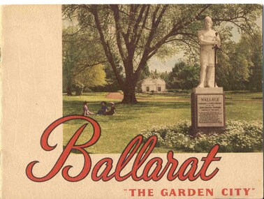
Book, Nu-color-vue or Nucolorvue Productions, "Ballarat - 'The Garden City' ", late 1940's or early 1950s
Yields information about Ballarat through pictures of the 1940-50's various locations, institutions and street scenes, including tramways. Good comparison with earlier books, eg Item 3900.24 page book, plus embossed covers saddle stapled with two staples titled "Ballarat - 'The Garden City' ". Features photographs of Ballarat and district - full colour with accompanying text about Ballarat and its history. Cover features Gardens view with statute of Wallace in foreground - see image c1 p3 - photo of No. 22 (bogie) at Grenville St in Sturt St with a single trucker behind in the City loop - see image c2 - see also Reg Item 5354 for a postcard version. p5 - Eureka Stockade memorial p6 - Lake Wendouree p7 - Sturt St with Town hall in background, and No. 33 in Sturt St. south side. p9 - Begonia hothouse p10 - St Andrews Kirk p11 - St Peter's Church of England p12 - Lake Wendouree p13 - Botanical Gardens p14 - Monuments and statues around Ballarat p15 - Post Office, State Offices, Ballarat Orphanage and Queen Elizabeth Benevolent Home p16 - A Ballarat Reservoir p17 - Botanical Gardens p18 - Gordon's Cottage, Congregational Church, Lydiard St and The Cenotaph p19 - Ballarat Grammar School, St. Patrick's Cathedral (no spire), St. Patrick's College, street scene p20 - Arch of Victory, Lake Wendouree, Sturt St with tram in distance and Eureka Swimming pool p22 - Avenue of Prime Ministers p23 - Harvest near Mt Warrenheip, Country side photo, I&R Morley Pty Ltd factory and houses in the lake area. Purchased through eBay 25/10/2004. See worksheet for eBay emails. See also Reg. Item 3041 for the same image of No. 22. 2nd Copy added 26/12/2007 - donation of Ron Scholten. pdf image of the full book added 8/5/19 as btm2925i.pdf trams, tramways, ballarat, sturt st, history, gardens -
 Ballarat Tramway Museum
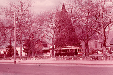
Slide - 35mm slide/s, Glen Mills, Sept. 1971
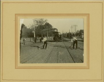
White cardboard mount, 35mm slide, from the Association of Railway Enthusiast's film strip titled "Provincial Tramway Film Strip" of Tram 12 bound for Gardens, photographed across the median strip plantation near Dawson St. with St. Peters Church in the background. The film strip notes (Reg. Item 2560), provided the following caption details: "The wide Avenue of Sturt St. was the central spine of the Ballarat system -all routes traversed it for at least part of its length. Here No. 12 "GARDENS" bound, is seen through the foliage of the centre plantation in Sturt St. -Sept. '71 (Glen Mills)" See image btm2567p.tif for high level scan of image. Stamped on base of slide "11777" and written in ink on top edge "No. 12 Sturt St Ballarat"tramways, trams, are, film strip, sturt st, st peters, tram 12 -
 Kew Historical Society Inc
Plan, Melbourne & Metropolitan Board of Works : Borough of Kew : Detail Plan No.1591, 1905
The Melbourne and Metropolitan Board of Works (MMBW) plans were produced from the 1890s to the 1950s. They were crucial to the design and development of Melbourne's sewerage and drainage system. The plans, at a scale of 40 feet to 1 inch (1:480), provide a detailed historical record of Melbourne streetscapes and environmental features. Each plan covers one or two street blocks (roughly six streets), showing details of buildings, including garden layouts and ownership boundaries, and features such as laneways, drains, bridges, parks, municipal boundaries and other prominent landmarks as they existed at the time each plan was produced. (Source: State Library of Victoria)This plan forms part of a large group of MMBW plans and maps that was donated to the Society by the Mr Poulter, City Engineer of the City of Kew in 1989. Within this collection, thirty-five hand-coloured plans, backed with linen, are of statewide significance as they include annotations that provide details of construction materials used in buildings in the first decade of the 20th century as well as additional information about land ownership and usage. The copies in the Public Record Office Victoria and the State Library of Victoria are monochrome versions which do not denote building materials so that the maps in this collection are invaluable and unique tools for researchers and heritage consultants. A number of the plans are not held in the collection of the State Library of Victoria so they have the additional attribute of rarity.Original survey plan, issued by the MMBW to a contractor with responsibility for constructing sewers in the area identified on the plan within the Borough of Kew. The plan was at some stage hand-coloured, possibly by the contractor, but more likely by officers working in the Engineering Department of the Borough and later Town, then City of Kew. The hand-coloured sections of buildings on the plan were used to denote masonry or brick constructions (pink), weatherboard constructions (yellow), and public buildings (grey). That area of Kew bordered by Cotham Road, Park Hill Road, Ermington Lane (now Ermington Place), and Belmont Avenue contained some of the significant homes owned by Kew pioneers. Chief among these was ‘Park Hill’ on an enormous lot facing Park Hill Road. The Jubilee History of 1910 noted, six years after this plan was drawn, that: ‘Park Hill Road, forming the southern boundary of the cemetery, takes its name from Park Hill, the residence of Mr. Thomas Judd, who has resided there since December, 1852.’ Other named houses on the plan include ‘Ferndale’ facing Cotham Road; ‘Ermington’ adjacent to Judd’s Park Hill, facing Park Hill Road; and ‘Gilden’ and ‘Mont Belmont’ facing Belmont Avenue. Mont Belmont was designed by the architectural firm of Reed, Henderson and Smart for William George Lilley in 1887 and was completed in 1888. Lilley was Mayor of Kew in 1887-88, a Justice of the Peace and a member of the first Board of Guardians of Kew’s St. Hilary’s Church of England.melbourne and metropolitan board of works, detail plans, survey plans - borough of kew, mmbw 1591, cartography -
 Kew Historical Society Inc
Album - Scrapbook, Eva Grant, Historic Buildings, Kew, 1958-78, 1970s
One of three scrapbooks of photographs and newspaper cuttings taken and or collected by Eva Grant, a past member of the Kew Historical Society, which were donated by her niece, Julie Thomson. The albums include many photographs of Kew from the 1950s to the 1970s. Buildings included in the scrapbook include: Billy Hughes' house - 167 Cotham Road Congregational Church - Walpole Street (c.1978) Country Roads Board - Denmark Street (1960) Dorothy Rogers Reserve - Studley Park Road Ellsmere (also Ellesmere/Ellsmore) - Princess Street Field Place - 3 Henty Court Fernhurst - 13 Fernhurst Grove Kew Civic Centre (1959) Kew Junction (1958) Kew Railway Station (1902, 1959) Kew Recreation Hall - Wellington Street (1960) Neama (Hall) - Studley Park Road Southesk (formerly Ordsall) - Cotham Road (c.1960) St Anthony's Home for Babies (formerly Madford) - 43 Wellington Street (c.1976) Studley House - Nolan AvenueThe scrapbook contains historically significant, rare and sometimes unique images of significant heritage buildings in Kew, including their erection and demolition. 11-page scrapbook of photographs and newspaper clippings with annotations by Eva Grant, a past member of the Kew Historical Society. The pages of the album can be viewed in the image carousel above. Based on the text and known dates of demolition of a number of the buildings, the scrapbook was assembled over a twenty year period between c.1958-c.1978.Includes letter from donoreva grant, billy hughes' house - 167 cotham road, congregational church - walpole street - kew, country roads board - denmark street - kew, dorothy rogers reserve - studley park road - kew, field place - 3 henty court - kew (vic), ellsmere (also ellesmere/ellsmore) - princess street - kew, fernhurst - 13 fernhurst grove - kew (vic), kew civic centre - civic drive - kew (vic), kew junction - kew (vic), kew railway station - denmark street - kew (vic), recreation hall - wellington street - kew, neama - hall - studley park road - kew (vic), southesk - ordsall - cotham road- kew (vic), st anthony's home for babies - madford - 43 wellington street (vic), studley house - nolan avenue - kew (vic) -
 Kew Historical Society Inc
Journal, Kewriosity : November 1987
Home Helpers in Pilot Training Program / p1. [Woodlands Avenue] Playgroup enrolments / p1. Help wanted [Australia's Bicentennial Choir] / p1. Christmas cards / p1. Dates for November / p2. Images of Kew [Photographic competition; Australia's Bicentennial] / p2&7. Commentary / Cr Jim Tutt, Mayor of Kew [1987/88 Council Budget] / p3. Church centenary [Kew Presbyterian Church] / p3. [Community] Notices / p4. Volunteers needed [Asthma Foundation of Victoria] / p4. Kinder for three year olds [North Kew Municipal Kindergarten] / p4. Community Directory update / p4. Belford Oaks [Childcare Centre] / p4. Mayoresses' luncheon focuses on Asthma / p5. Recycling reminder / p5. Bicentennial notes / p5. Kew Community House / Judy Price p6. Help for fundraisers / p6. [Kew] Youth Resource Centre / p6. How much can a Library Bear bear? / p7. New citizens / p7. Croquet - not just a game, but an enigma [Kew Croquet Club] / p7. Keeping you informed [Citizens Advice Bureau] / p8. Good gardening / p8. Boroondara Bushwalkers / p8. Entry form for 'Images of Kew' / p8Kewriosity was a local newsletter combining Kew Council and community news. It was published between November 1983 and June 1994, replacing an earlier Kewriosity [broad] Sheet (1979-84). In producing Kewriosity, Council aimed to provide a range of interesting and informative articles covering its deliberations and decision making, together with items of general interest and importance to the Kew community and information not generally available through daily media outlets.non-fictionHome Helpers in Pilot Training Program / p1. [Woodlands Avenue] Playgroup enrolments / p1. Help wanted [Australia's Bicentennial Choir] / p1. Christmas cards / p1. Dates for November / p2. Images of Kew [Photographic competition; Australia's Bicentennial] / p2&7. Commentary / Cr Jim Tutt, Mayor of Kew [1987/88 Council Budget] / p3. Church centenary [Kew Presbyterian Church] / p3. [Community] Notices / p4. Volunteers needed [Asthma Foundation of Victoria] / p4. Kinder for three year olds [North Kew Municipal Kindergarten] / p4. Community Directory update / p4. Belford Oaks [Childcare Centre] / p4. Mayoresses' luncheon focuses on Asthma / p5. Recycling reminder / p5. Bicentennial notes / p5. Kew Community House / Judy Price p6. Help for fundraisers / p6. [Kew] Youth Resource Centre / p6. How much can a Library Bear bear? / p7. New citizens / p7. Croquet - not just a game, but an enigma [Kew Croquet Club] / p7. Keeping you informed [Citizens Advice Bureau] / p8. Good gardening / p8. Boroondara Bushwalkers / p8. Entry form for 'Images of Kew' / p8publications -- city of kew (vic.), kewriosity, council newsletters, community newsletters -
Kew Historical Society Inc
Journal, Kewriosity : April 1985
... [Woodlands Avenue Baptist Church Hall] / p8. A fond farewell ...Occasional Care [Centre] is a winner [Strathalbyn Street] / p1. And what a Parade it was! [Kew Festival] / p1. Community Notices - General; Clubs and societies; Religious notices; Politics; Auxiliaries; Support Groups] / p2&8. Update: Notes from Council - Trees: Our heritage [street trees] / Cr Robin Saunders [Mayor of Kew] p3. Doorknock in traffic management Area 5 / p4. Driver needed! [Kew Community Bus] / p4. We have a place for your child! [Davis Street Kindergarten] / p4. Council supports Community Employment Program / p4. New Residents Kit / p4. What is a playgroup? [Highbury Grove Playgroup] / p5. Future planning for children's services / p5. Don't burn those leaves / p5. Kew Community House [short courses] / p5. Youth Page: What does the Youth Services Officer do? Junior footballers: where are you? [Kew Football Club]; Youth groups - let more people know about your club; Recreation and enjoyment / p6. Proposed Kew Full Day Care Centre / p7. Greek Easter / p7. "Spring" Festivals and the origins of the Easter Bunny / p7. This Kewriosity is being delivered to you by - Kew Preschool Support Group [Woodlands Avenue Baptist Church Hall] / p8. A fond farewell to A.C.K.D.A. [Artists’ Co-operative for the Kew/Deepdene area] / p8.Kewriosity was a local newsletter combining Kew Council and community news. It was published between November 1983 and June 1994, replacing an earlier Kewriosity [broad] Sheet (1979-84). In producing Kewriosity, Council aimed to provide a range of interesting and informative articles covering its deliberations and decision making, together with items of general interest and importance to the Kew community and information not generally available through daily media outlets.non-fictionOccasional Care [Centre] is a winner [Strathalbyn Street] / p1. And what a Parade it was! [Kew Festival] / p1. Community Notices - General; Clubs and societies; Religious notices; Politics; Auxiliaries; Support Groups] / p2&8. Update: Notes from Council - Trees: Our heritage [street trees] / Cr Robin Saunders [Mayor of Kew] p3. Doorknock in traffic management Area 5 / p4. Driver needed! [Kew Community Bus] / p4. We have a place for your child! [Davis Street Kindergarten] / p4. Council supports Community Employment Program / p4. New Residents Kit / p4. What is a playgroup? [Highbury Grove Playgroup] / p5. Future planning for children's services / p5. Don't burn those leaves / p5. Kew Community House [short courses] / p5. Youth Page: What does the Youth Services Officer do? Junior footballers: where are you? [Kew Football Club]; Youth groups - let more people know about your club; Recreation and enjoyment / p6. Proposed Kew Full Day Care Centre / p7. Greek Easter / p7. "Spring" Festivals and the origins of the Easter Bunny / p7. This Kewriosity is being delivered to you by - Kew Preschool Support Group [Woodlands Avenue Baptist Church Hall] / p8. A fond farewell to A.C.K.D.A. [Artists’ Co-operative for the Kew/Deepdene area] / p8. publications -- city of kew (vic.), kewriosity, council newsletters, community newsletters -
Kew Historical Society Inc
Journal, Kewriosity : November 1984
60th issue / p1. "Woodlands Avenue" to accomodate 3YO's [Kew Pre-School Support Group; East Kew Baptist Church] / p1. [Kew] Community Festival extended / p1. Books and games for children / p2. 68th Anniversary Hyde Park Uniting Church / p2. Seniors & Lions / p2. Kew [Daytime] Garden Club / p2. Action Programme [Rheumatism and Arthritis Association of Victoria] / p2. Hyde Park Uniting Church Fellowship / p2. Mayoral Column [Council Budget] / p3. A foster family's experience [Inner East Foster Care] / p4. Volunteer helpers needed / p4. Aspects of alcohol use in the community / p4. Kew Citizens' Band / p4. Youth Pages - Welcome [Kew appoints full time youth worker - Ian Patching; International Youth Year 1985; Youth Resource Centre] / p5. Summer - a time for recreation / p6. [Kew] Recreation Centre update - Report from Consultative Committee / p7. Traffic management / p7. Things to do in Kew / p8. Occasional Care Centre / p9. Library news / p9. Tipping facilities / p9. Senior Citizens' Activity Groups in Kew / p9. Kew/Hawthorn Citizens' Advice Bureau / p10. Kalker Montessori Kindergarten / p10. The Billabong Club / p10. Australian Labor Party / p10. Kew Garden Club and Native Plant Group / p10. Parents of Gays / p10. Kew Community House Annual Report [Glendonald; Elderly; Youth; Unemployed; Single parents; Counselling?; Citizens Advice Bureau; Churches; Mural; Courses & Activities; Drop-in Centre; Volunteers] / Mary Scomazzon p11-12. Kew Community House Youth Group / p12.Kewriosity was a local newsletter combining Kew Council and community news. It was published between November 1983 and June 1994, replacing an earlier Kewriosity [broad] Sheet (1979-84). In producing Kewriosity, Council aimed to provide a range of interesting and informative articles covering its deliberations and decision making, together with items of general interest and importance to the Kew community and information not generally available through daily media outlets.non-fiction60th issue / p1. "Woodlands Avenue" to accomodate 3YO's [Kew Pre-School Support Group; East Kew Baptist Church] / p1. [Kew] Community Festival extended / p1. Books and games for children / p2. 68th Anniversary Hyde Park Uniting Church / p2. Seniors & Lions / p2. Kew [Daytime] Garden Club / p2. Action Programme [Rheumatism and Arthritis Association of Victoria] / p2. Hyde Park Uniting Church Fellowship / p2. Mayoral Column [Council Budget] / p3. A foster family's experience [Inner East Foster Care] / p4. Volunteer helpers needed / p4. Aspects of alcohol use in the community / p4. Kew Citizens' Band / p4. Youth Pages - Welcome [Kew appoints full time youth worker - Ian Patching; International Youth Year 1985; Youth Resource Centre] / p5. Summer - a time for recreation / p6. [Kew] Recreation Centre update - Report from Consultative Committee / p7. Traffic management / p7. Things to do in Kew / p8. Occasional Care Centre / p9. Library news / p9. Tipping facilities / p9. Senior Citizens' Activity Groups in Kew / p9. Kew/Hawthorn Citizens' Advice Bureau / p10. Kalker Montessori Kindergarten / p10. The Billabong Club / p10. Australian Labor Party / p10. Kew Garden Club and Native Plant Group / p10. Parents of Gays / p10. Kew Community House Annual Report [Glendonald; Elderly; Youth; Unemployed; Single parents; Counselling?; Citizens Advice Bureau; Churches; Mural; Courses & Activities; Drop-in Centre; Volunteers] / Mary Scomazzon p11-12. Kew Community House Youth Group / p12. publications -- city of kew (vic.), kewriosity, council newsletters, community newsletters -
 Kew Historical Society Inc
Photograph - Electric tram line construction in Cotham Road, Kew, E.J. Dower, 1913
One of a series of photographs, taken by Edgar James Dower in the second decade of the twentieth century. Born and raised in Olinda, his family later moved to Surrey Hills. He worked as an adult as a clerk in the city office of the Metropolitan Gas Company, and in his role as a 'collector', he was able to photograph scenes including the construction of tramlines and associated buildings in Kew, Hawthorn, Camberwell and Surrey Hills. Later he established a real estate agency with his brother - the E.J. Dower Real Estate Agency, Dandenong Office.The image is an historically significant record of the development of transport infrastructure which was used to connect Victorians in the first two decades of the twentieth century. This development resulted from increases in population and the consequent extension of Melbourne's suburbs. The photographs, both individually and collectively, richly detail the labour of workers and the tools and machinery used to create and extend Melbourne's tram network in the years preceding and during World War 1.Digital copy of an original mounted photograph depicting construction of a new electric tramline in Cotham Road, Kew. The photo shows workers and a steamroller. The spire of the Kew Presbyterian Church can be seen in the distance.Annotated verso: "Preparing for electric trams / Cotham Road Kew / Taken near Barrington Avenue / Taken by E.J. Dower / 1913"theme --- travelling by tram, theme -- connecting victorians by transport and communications, cotham road -- kew (vic.), trams -- kew (vic.) -
 Kew Historical Society Inc
Plan, F R Simms & Son, Land for Private Sale: Cnr Victor Avenue and Mont Victor Road, Kew, 1950-1960
George Rimington established The Parkhill Nursery in 1877. By 1910, it was more commonly known as Rimington’s Nurseries and well known for its sale of violets. After World War II, Rimington’s Nurseries were gradually subdivided and sold. The 38 allotments were released in sections, including lots 34 to 36 on the corner of Mont Victor Road and Victor Avenue. Previous lots in the subdivision had bordered Burke Road, Rimington Avenue, Heather Grove, and Stoke Avenue. The selling point as it had been in comparable estates for a century were the proximity to transport, schools and churches, as well as the high location and excellent views. The subdivision plan shows most of the lots in the entire subdivision: 1-11, 13-26, and 34-38. Presumably, lot 12 and lots 27-33 were still to be released.Subdivision plans are historically important documents used as evidence of the growth of suburbs in Australia. They frequently provide information about when the land was sold on which a built structure was subsequently constructed as well as evidence relating to surveyors and real estate and financial agents. The numerous subdivision plans in the Kew Historical Society's collection represent working documents, ranging from the initial sketches made in planning a subdivision to printed plans on which auctioneers or agents listed the prices for which individual lots were sold. In a number of cases, the reverse of a subdivision plan in the collection includes a photograph of a house that was also for sale by the agent. These photographs provide significant heritage information relating house design and decoration, fencing and household gardens.Subdivision plan advertising five superb home sites among lots in Burke Road, Stoke Avenue, Victor Avenue, Mont Victor Road and Heather Grove.subdivision plans - kew, rimington avenue -- kew (vic.), heather grove -- kew (vic), stoke avenue -- kew (vic.), burke road -- kew (vic.), mont victor road -- kew (vic.) -
 Kew Historical Society Inc
Plan - Subdivision Plan, Raheen Estate Subdivision, 1960
Subdivision plans are historically important documents used as evidence of the growth of suburbs in Australia. They frequently provide information about when the land was sold on which a built structure was subsequently constructed as well as evidence relating to surveyors and real estate and financial agents. The numerous subdivision plans in the Kew Historical Society's collection represent working documents, ranging from the initial sketches made in planning a subdivision to printed plans on which auctioneers or agents listed the prices for which individual lots were sold. In a number of cases, the reverse of a subdivision plan in the collection includes a photograph of a house that was also for sale by the agent. These photographs provide significant heritage information relating house design and decoration, fencing and household gardens.The Raheen Estate Subdivision of 1960 involved the creation of 36 residential allotments and the sale of 34 of these. The land on which the subdivision was created had until 1960 formed part of the grounds of the mansion Raheen in Studley Park Road. In 1917, the Catholic Church had purchased Raheen and its lands. It was to become the home of Archbishop of Melbourne, Daniel Mannix, for 46 years. The sale of the subdivision took place three years before the Archbishop’s death. Subsequent archbishops were to reside at Raheen until its sale to the Pratt family in 1981. When the sale of the Estate was reported in the newspapers in 1960, it was described as the last big subdivision near Melbourne. At the auction, 33 of the 36 allotments were sold. The auction realised £315,750. Purchasers were advised that the vendor intended to keep lots 22 and 23. The alllotments in the subdivision required the construction of new roads. These included Eamon Court and Raheen Drive. The justification provided by the Church for the sale was that the estate was being sold to finance school building projects.subdivision plans - kew, studley park, raheen estate, eamon court, studley park road, coombes avenue, raheen drive -
 Kew Historical Society Inc
Plan - Subdivision Plan, Boulevard Estate - Boulevard Section, 1930-1936
Pru Sanderson, in her groundbreaking ‘City of Kew Urban Conservation Study : Volume 2 - Development History’ (1988), summarised the periods of urban development and subdivisions of land in Kew. The periods that she identified included 1845-1880, 1880-1893, 1893-1921, 1921-1933, 1933-1943, and Post-War Development. These periods were selected as they represented periods of rapid growth or decline in urban development. An obvious starting point for Sanderson’s groupings involved population growth and the associated economic cycles. These cycles also highlighted urban expansion onto land that was predominantly rural, although in other cases it represented the decline and breakup of large estates. A number of the plans in the Kew Historical Society’s collection can also be found in other collections, such as those of the State Library of Victoria and the Boroondara Library Service. A number are however unique to the collection.The Kew Historical Society collection includes almost 100 subdivision plans pertaining to suburbs of the City of Melbourne. Most of these are of Kew, Kew East or Studley Park, although a smaller number are plans of Camberwell, Deepdene, Balwyn and Hawthorn. It is believed that the majority of the plans were gifted to the Society by persons connected with the real estate firm - J. R. Mathers and McMillan, 136 Cotham Road, Kew. The Plans in the collection are rarely in pristine form, being working plans on which the agent would write notes and record lots sold and the prices of these. The subdivision plans are historically significant examples of the growth of urban Melbourne from the beginning of the 20th Century up until the 1980s. A number of the plans are double-sided and often include a photograph on the reverse. This plan shows a subdivision with two sections: the ‘Boulevard Section’ and the ‘Riverside Section’. The first of these sections bordered Burke Road between Kilby Road and the farm beside the Yarra. Kilby Road, Munro Road, Burke Road and Old Burke Road bordered the 102 lots in the Boulevard Section of the plan. The streets within the Section included Walbundry Avenue, Inverness Way, Riverside Avenue, Cascade Street and Kyora Parade. These street names, at least in this subdivision plan linked the two Sections of the subdivision. At a later date, the City of Kew decided to alter the street names. Walbundry, Inverness, Riverside, Cascade and Kyora were all renamed as ‘Drives’ (e.g. Kyora Drive). The subdivision plan is of interest in that it names High Street in Kew as Doncaster Road. It also shows the location of the wooden church that was later removed to Yarraville on the corner of Kilby Road and High Street. The plan predates later developments such as the S. E. Dickens Supermarket.subdivision plans - east kew, boulevard estate, munro road -- kew east (vic.), kilby road -- kew east (vic.), burke road -- kew east (vic.), walbundry avenue -- kew east (vic.), inverness way -- kew east (vic.), riverside avenue -- kew east (vic.), cascade drive -- kew east (vic.), nyora parade -- kew east (vic.) -
 Kew Historical Society Inc
Album - Photographs of heritage sites in Victoria, Eva Grant, 1964-66
Eva Grant was a member of the Kew Historical Society. Three albums in the collection were created by her, this one, the third created between 1964 and 1966. They were donated to the Society by her daughter in 2010. Each of the albums includes photographs and newspaper cuttings collected on her travels to historic places in South East Australia in the 1950s and 1960s. Particular structures photographed in this album include: Barnawatha (Vic.) - The Hermitage | Beveridge (Vic.) - Stone cottage where Ned Kelly was born. | Brighton - St Andrew’s Church graveyard. | Chiltern (Vic.) - lake view [missing] | Cowes (Vic.) - ‘Broadwater’ [originally home of Henty-Wilson family], demolished 1965; Bell of the Speke wreck; Edward’s tree. | Euroa (Vic.) - Habbies Howe | Fairfield (Vic.) - Dight’s Falls; John Dight. | Fernshawe (Vic.) - Queen Mary tree. | Jolimont (Vic.) - Old railway tunnel linking the first Government House (1964); Sign identifying location of first Government House. | Kew (Vic.) - Cairn at Dight’s Falls; Canoe tree, Bowyer Avenue. | Kyneton - De Grave’s Flour Mill - “C”. | Maldon (Vic.) - Chinese oven; Macarthur’s House; Maldon’s oldest resident; Chinese graves x 2; [Beehive Chimney]. | Marysville (Vic.) - Centenary cairn | Mitcham (Vic.), Mud brick house x 2, Deep Creek Road. | Melbourne (Vic.) - St Paul’s Cathedral [renovation] (1964); Wreckers at Damman’s Corner, cnr Bourke and Collins Streets (1964); Princess Gate project x 2 (1964); Colonial Storekeeper’s building on cnr King and Bourke Streets (1966); Early observatory 1861-3; the Honey Memorial. | Mt Oberon (Vic.) - [obsolete] radio telephone dish. | Seymour (Vic.) - Habres (sic) House x 3.| Swan Hill (Vic.) - Major Mitchell’s Cairn (12/1964); Headstone of Andrew Beverage AM (12/1964). | Templestowe (Vic.) - Finn’s Hotel. | Thornton (Vic.) - Eildon Station. | Werribee (Vic.) - Chirnside Memorial [Presbyterian] Church; gaslight beside church | Location unknown, but possibly Swan Hill - Brick house; Wooden bullock dray. | Location unknown - Headstone of John Furlonge 1835.Important record of significant heritage properties in Victoria, many of which have since been demolished.30 page spirex bound drawing book including photographs and newspaper articles of historic buildings in Victoria. The front cover has a picture of a steam boat. The cover is encased in plastic. A number items in the album are annotated with written commentary by Eva Grant who compiled the album. Annotations and transcriptions by Eva Grant on most imageseva grant, photograph albums, heritage places - victoria -
Surrey Hills Historical Society Collection
Document - Plans, Andrew Wood, Building plans associated with Andrew Wood, builder of Surrey Hills, 1920s
These plans were associated with Mr Andrew Wood, a contract builder who worked in the 1920s and built many Californian bungalows in Surrey Hills and surrounding suburbs. Andrew Wood was born in Chiltern in 1861 to Andrew and Ellen Wood (MS: Green). His father had emigrated from Falkirk, Scotland. As a young man Andrew worked as a carpenter in the mines in South Africa (c 1899). He married Eleanor Agnes Stuchbery in Hamilton, Victoria in May 1901. They had 5 children - Doris (M Roberts), Robert Andrew, Donald Allen, Jean (M Cowan), and Gwenyth (M Bray). The first 2 children were born in Hawthorn; the other 3 in Surrey Hills. The family home at 286 Canterbury Road, Surrey Hills (on the corner of Middlesex Road) was built by Andrew. Andrew died in 1940; Eleanor died in 1977, aged 100 years. After Eleanor's death the house was sold and demolished. Surrey Lighting was established on the site. Gwenyth May Wood (3 May 1917, Surrey Hills - 5 Jan 2004) married Leslie David Charles Bray (1921-1983). Gwenyth was the donor's mother. Andrew, Eleanor and one son Robert are buried in Box Hill Cemetery - B-071-0028. .1: Specifications & plans for the kinder hall, Howard Street, Mont Albert for the Mont Albert Methodist Church, May 1925 .2 Plans for a proposed villa, 48 Payne's Paddock, Highfield Road, Canterbury for Mr E H Sillifant, dated 22/4/1920 .3 Plans for a timber villa for Mrs J A Burchell at Riversdale Road, Surrey Hills, stamped 9/5/1922 .4 Plan of a garage at Victoria avenue, Canterbury; stamped 14/2/1922 .5 Building permit & receipt from City of Hawthorn re Lot 16 Homebush Crescent; dated 7/4/1925 .6 Plans for a concrete house at Camberwell for Mr H W Field andrew wood, builders, box hill cemetery, kindergartens, mont albert methodist church, building plans, highfield road, ernest horatio sillifant, victoria avenue canterbury, lot 16 homebush crescent, californian bungalows, h w field -
 Surrey Hills Historical Society Collection
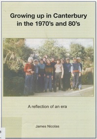
Book, Growing up in Canterbury in the 1970s and 80s:a reflection of an era, 2015
This is a recollection of what was one person's view on growing up in Willandra Avenue, Canterbury and the surrounding area.This is a recollection of what was one person's view on growing up in Willandra Avenue, Canterbury and the surrounding area.|20 pages(mr) james nicolas, childhood and youth, canterbury, willandra avenue, scouts, (mrs) betty ballantyne, (mr) - hawkens, (mrs) - hawkens, (mrs) - thomas, (mr) phillip anderson, kranjcics family, (mr) john proper, (dr) (mr) - barton, (mr) - phillips, (mr) - goff, (mrs) - mcmillan, (mr) - mceroy, (miss) caroline harris, (mr) - ielpo, (mr) graeme brent, (mr) peter brent, (mrs) tuyet brent, buckingham family, (mrs) - proper, billings family, howats family, canterbury football club, (mr) jim shepherd, (mrs) lillian shepherd, tulloch begg, house names, salvation army, (mr) (dr) alan williams, dentists, doctors, malone's hotel, canterbury mansions, (mr)(father) - potter, (mrs) - kerr, (mr) - kerr, canterbury cricket club, the gunyah, (mr) jim richards, (mr) "rainbow" simpson, canterbury football club, (mr)(cr) - maling, (sir) (mr) aaron danks, logan family, hasset family, staig family, (mr) tony petroro, outer circle, canterbury presbyterian church, bradshaw's mechanic, (mr) francis bourke, emulation hall, (mr) - cameron, (mr) - lathan, canterbury primary school, vozzo's milk bar, camberwell high school, (mr) - de munk, (mr) - howie, (miss) - patterson, (mr) - collins, (miss) kylie minogue, (mr) craig mcdonnell, (mr) dean mcdonnell, (miss) danni minogue, (mr) jack) morris, (mrs) marjorie rowe, (mr) andrew rowe, (mr) peter rowe, (mr) richard rowe, (mr) richard rowe, (mr) frank kelly, gagliardi family, (mr) phillip graham, mcdonnell family, sutherland family, toddle inn, rooney's butcher -
 Surrey Hills Historical Society Collection
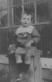
Digital photo, Alan Holt as an infant, c1914
Alan Judge Holt as an infant. He was born 16 June 1912, one of 3 sons of Edmund Holt and his wife Ruby Ellen Sutton. His brothers were Frederick Sutton Holt (1914-1992) and Raymond James Holt (1918-2000). The family home was 9 Beatrice Avenue, Surrey Hills and the family were active members of the Surrey Hills Methodist Church. Alan married Edna Jean Pallot in 1937 and they too had 3 sons - Barry, Neville and Max. Alan and Edna and family lived at 62 Broughton Road, Surrey Hills; later Alan and Edna lived at 2 Earle Street, Mont Albert and finally 13 Berry Street, Box Hill. Alan became Secretary of the Victorian Lands Department. He was passionate about local history and was responsible for much of the backbone research and records of the Surrey Hills local history collection. He died in 1993.A young Alan Judge Holt sitting on a box. Estimated age is 2 years.alan holt, alan judge holt, infants -
 Surrey Hills Historical Society Collection
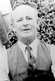
Photograph, Mr Edmund Holt
Mr Edmund Holt From 1913 he and his wife made their home at 9 Beatrice Avenue. Both were involved with the Methodist Church and its activities. Mr Holt was a railways officer and retired while in charge of the Stores Branch at the Newport Workshops where the workload was vastly increased because of wartime demands for increased production as well as necessary maintenance. He died 1945. A black and white photograph of a man, dressed in a waistcoat, shirt and tie, and not much hair.(mr) edmund holt, methodist church, surrey hills, railways officer, beatrice avenue, choir member, liedertafel choir -
 Surrey Hills Historical Society Collection
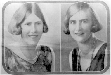
Photograph, Nancy and Hattie Steele
Nancy (Margaret Dillon) Steele born 1906 and Hattie ( Harriette Vevers) Steele were daughters of Charles Henri Dillon Steele (1869-1935) and Sarah Margaret Russell (1873-1944),he was a pioneer of dentistry in Victoria who was in practice in 1890 and later in Collins Street for 40 years. The family lived at ‘Dalriada’ (dem.) on the corner of Bona Vista Avenue and Union Road. Sarah Margaret Steele was President of the local Patriotic League during WW1 and is credited with starting the move to raise funds for the WW1 memorial in the Surrey Gardens. Nancy and Hattie were graduates at Melbourne University in Dentistry and Agricultural Science respectively. They continued their studies in Toronto and obtained their Doctorates. In 1923 Nancy and Hattie started the first girl guide group in Surrey Hills at Holy Trinity Church. Both married and had families. Nancy married Dr William Brayshaw Woodhouse and, while he took up army duties during World War II, Nancy continued his practice. Their son Anthony became a dentist, while Peter was known locally when he became a councillor and Mayor of Camberwell. Their daughter Margaret married Herbert Andrewartha and lived in NSW.A black and white photograph of two portraits of two young ladies. Their dress and hair styles are suggestive of a 1920's date..(miss) nancy (margaret) steele, (miss) hattie vevers steele, dalriada, house names, bona vista avenue, union road, surrey hills, dentists, first girl guide group, 1923, holy trinity church, world war, 1939-1945, mayors, councillors, (miss) margaret brayshaw-woodhouse, dr william brayshaw woodhouse, peter brayshaw woohdhouse, dr charles henri dillon steele, dr anthony brayshaw woodhouse, (miss) nancy steele, (mrs) nancy andrewartha, (miss) hattie steele, (miss) harriette vevers steele, (mrs) margaret brayshaw woodhouse, (miss) margaret dillon steele, (miss) sarah margaet russell, (mes) sarah margaret steele -
 Surrey Hills Historical Society Collection
Photograph - Digital photo, 1922-1925
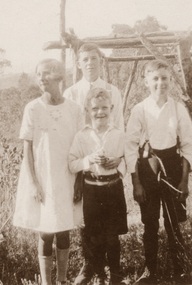
Alan Judge Holt (1912-1993), Frederick Sutton Holt (1914-1992) and Raymond James Holt (1918-2000) were the children of Edmund Holt (1881-1945) and Ruby Ellen Sutton (1889-1961). The family had multiple associations with Surrey Hills, in particular the Surrey Hills Methodist Church. Associated homes were in Beatrice Avenue and Broughton Road. Alan Judge Holt became secretary of the Victorian Lands Department and his meticulous research laid the foundations of the SHNCHC. The relationship of Dot to the family needs clarification. The Holt family held many connections with the local Surrey Hills community with Alan Holt's research a valuable part of the Surrey Hills Heritage Collection.A digital copy of a sepia photo with 4 children in a garden setting - Dot, Alan, Ray and Fred Holtchildren, siblings, family portrait -
 Surrey Hills Historical Society Collection
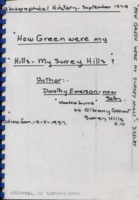
Book, Dorothy Selby (nee Emerson), How green were my hills - my Surrey Hills, September 1979
A biographical history by Dorothy Selby (nee Emerson) recollecting the people she came into contact with during her time in Surrey Hills from 1915-1937.A4, comb binding, 9 pageshouse names, kookaburra, albany crescent, surrey hills, (miss) dorothy emerson, (mrs) dorothy emerson, warrigal road, boundary road, st stephen's presbyterian church, (mrs) - gillies, (mr) tom ward, dentist, (mrs) - bowen, edwardian style, royal hotel, broughton road, (mrs) - brogan, (mr) - brogan, (mr) - tuckett, tacey's butcher, (mr) james tait, draper, (mr) alfred rose, state savings bank, surrey college, tower house college, balmoral crescent, (mr) - clewett, (mr) percy blood, stenning and holyoak, grocers, (mr) - pell, greengrocer, confectioner, fishmonger, (mr) tommy everon, (miss) beatrice bligh, (mr) - lyons, (mr) - ray, surrey hills station, transport, (ms) kitty mcewan, golfer, taxis, (mr) - collins, surrey hills primary school, (dr) (mr) - forsythe, (dr) (mr) - gandever, windsor crescent, valonia avenue, victoria avenue, (mr) john blogg, progress association, rechabite hall, (mr) claude wardle, (miss) beatrice oakley, empire day, (mr) robert gordon menzies, girl guides, (ms) nancy steele, (ms) hattie steele, (dr) (mr) - blaikie, (mr) - richards, stationmaster, crime, (mr) - cockerill, (mr) horrie breedon, first enlistment, (mr) (rev) brazier, (mr) (rev) - oakes, (mr) (rev) - gillies, (mr) (rev) - mudford, (mr) (rev) - millikan, (mr) (rev) - cockett, (mr) (rev) alfred gifford, (mr) (fr) david gleeson -
 Surrey Hills Historical Society Collection
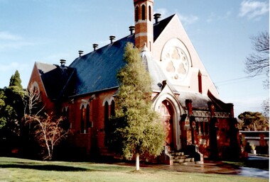
Photograph, St Stephen's Presbyterian Church, Surrey Hills, viewed from Warrigal Road, 1980's
The first service of the Surrey Hills Presbyterian Church was held at ‘Kinnoul’, the home of Thomas Hogg, located in The Avenue. This was while the church was being built. St Stephens Presbyterian Church opened in March 1899 on land that had previously been part of Klepper's orchard. The first minister was Rev F A Darling. He resigned in 1892 to open Surrey College. The church building pictured was built in 1910 adjacent on land gifted to the church. Noted features of the interior are the pulpit and honor board carved by sculptor John Kendrick Blogg. There are also memorial windows to Charles de Burgh Hogg and William Thomas Hogg, both killed in WW1.Red brick church with bell tower and slate roof. Cyprus tree at side; other trees fronting Canterbury Road.Canterbury Road - Warrigal Rd (written in biro on th back of photo)stained glass, lead lights, churches, presbyterian church, st stephens presbyterian church, 1980-1989, surrey hills, canterbury road, warrigal road, john kendrick blogg, charles de burgh hogg, thomas william hogg -
 Surrey Hills Historical Society Collection
Photograph, Surrey Hills Methodist Church in 1918, 1918
The original Methodist (Wesleyan) Church was built on the corner of Alexandra Crescent and Windsor Lane in 1888. It was enlarged in 1892. In 1908 this building was removed to Valonia Avenue by horse-drawn dray. The brick church was built in 1915 after which the earlier building became the Sunday School. In 1977 the Methodist Church joined with others to become the Uniting Church. In more recent times, the brick church has been painted but architectural details visible in this photo can still be discerned.Black and white photo of a brick and rendered building taken from diagonally opposite across Canterbury Road looking to the north-west. The church sits behind a woven-wire fence with an opening at the front and at the side to a portico off Valonia Street. On the RHS is the church hall and on the LHS a small part of the adjacent house can be seen.surrey hills methodist (wesleyan) church, surrey hills uniting church -
 Surrey Hills Historical Society Collection
Photograph, St George's Church of England, Mont Albert working bee, early 1923 (2), 1923
The foundation stone for St George's Church of England, Mont Albert was laid in 1886 on land donated by Edward Dyer and the first service was preached in January 1887. From 1904 until 1907 it was known as Holy Trinity, Surrey Hills. The original church was weatherboard and replaced by a brick one in the Gothic Revival style which was designed by local architect George J V Blackburne, who also designed the Wesleyan School at Surrey Hills. The building was partly funded by donations, profits from a bazaar and concert, and other people donated furnishings. The church had boundaries along Mont Albert Road and St Georges Road. In 1998 the Church was sold and converted into a complex of units. Its current address is 19 St Georges Avenue, Mont Albert. The purpose of this working bee in 1923 was to close up the double gateway, which in earlier times had been used for entry of by horse-drawn vehicles to the church grounds. 'Lugano' was built in 1893 for William Wilson, a prominent stonemason and importer of marble fireplaces. In 1903 it became the home of William Holmes who was Chief Electrical Engineer for the Victorian Railways. He designed the electrification of the Melbourne suburban network. 'Lugano' stayed in the Holmes family until the 1930s. Norman Carter took many photos of Surrey Hills and Mont Albert from the 1920s in particular of events and activities associated with the Church of England.Black and white photo of 6 men behind and in front of a picket fence, a section of which has posts and railings only. In front of the fence is a wide grassy verge on which a bench is set up for cutting lengths of wood. A large Victorian house ('Lugano') can be seen in the background and a lamp post with a street sign. Beyond the house are mature eucalyptus trees.churches, holy trinity church, anglican church, st george's anglican church, working bees, lugano, william holmes, william wilson, norman brodley carter -
 Surrey Hills Historical Society Collection
Photograph, Surrey Hills looking south-east from the steeple of Holy Trinity Church, 1921, 1921
The property in the foreground is 'Edgeware' at 171 Union Road, a house built by the Zeplin family. It became the home / residence of Dr Percy Liddle and later Dr James Landells Blakie. By the time this photo was taken Dr Blakie had moved across the road to 174 Union Road. In the background behind the 2 houses in the foreground is the Surrey Hills Stationmaster's house, sitting behind a picket fence. The Alan Holt register gives a build date of c1915 for this house, which fits stylistically. The first stationmaster was probably Michael Ginnane, who stayed in the area after he retired, moving to 1 Russell Street. This property was listed as 8 Bedford Avenue, the only house on the south side of the road. It was demolished in c1972 to make way for widening of the rail track with a third line. The photographer Norman Carter took many photos of Surrey Hills and Mont Albert from the 1920s, in particular of events and activities associated with the Church of England.Black and white photo taken from the steeple of Holy Trinity Church looking across housing towards the railway line and Albany / Windsor Crescents and on towards Canterbury Road. Surrey Hills Primary School and St Stephens Presbyterian Church feature prominently on the horizon. The stationmaster's cottage is centre left adjacent to a large conifer-like tree, with a white fence delineating the railway yards.On back of original: "6-11-21" and in a different hand in biro: "from tower of Holy Trinity Church"albany crescent, windsor crescent, st stephens presbyterian church, surrey hills primary school, railways, stationmasters' houses, bedford avenue, norman carter, edgeware, dr percy liddle, dr james blakie -
 Surrey Hills Historical Society Collection
Photograph, St George's Church of England, Mont Albert working bee, early 1923 (1), 1923
The foundation stone for St George's Church of England, Mont Albert was laid in 1886 on land donated by Edward Dyer and the first service was preached in January 1887. From 1904 until 1907 it was known as Holy Trinity, Surrey Hills. The original church was weatherboard and replaced by a brick one in the Gothic Revival style which was designed by local architect George J V Blackburne, who also designed the Wesleyan School at Surrey Hills. The building was partly funded by donations, profits from a bazaar and concert, and other people donated furnishings. The church had boundaries along Mont Albert Road and St Georges Road. In 1998 the Church was sold and converted into a complex of units. Its current address is 19 St Georges Avenue, Mont Albert. Norman Carter took many photos of Surrey Hills and Mont Albert from the 1920s, in particular of events and activities associated with the Church of England.Black and white photo of 4 men at a working bee in the grounds of St George's Anglican Church in Mont Albert. Two men are on a scaffold working on the weatherboards of the church; the other two are working on fencing. One boundary is marked with a paling fence; the other has a section of picket fencing and a large open section with no fencing. There is a mature eucalyptus tree in front of the church; others are beyond the paling boundary fence. The church itself is a simply constructed weatherboard building.churches, holy trinity church, anglican church, st george's anglican church, working bees, norman brodley carter -
 Surrey Hills Historical Society Collection
Photograph, Preparing to leave for the St George's Church of England Sunday School picnic, Mont Albert Road, 1922, 1922
The drags would have been leaving St George's Church of England in Mont Albert Road. The foundation stone for St George's Church of England, Mont Albert was laid in 1886 on land donated by Edward Dyer and the first service was preached in January 1887. From 1904 until 1907 it was known as Holy Trinity, Surrey Hills. The original church was weatherboard and replaced by a brick one in the Gothic Revival style which was designed by local architect George J V Blackburne, who also designed the Wesleyan School at Surrey Hills. The building was partly funded by donations, profits from a bazaar and concert, and other people donated furnishings. The church had boundaries along Mont Albert Road and St Georges Road. In 1998 the Church was sold and converted into a complex of units. Its current address is 19 St Georges Avenue, Mont Albert. The annual Sunday School picnic was held at Hampton and drags were the usual mode of transport. 'Lugano' was built in 1893 for William Wilson, a prominent stonemason and importer of marble fireplaces. In 1903 it became the home of William Holmes who was Chief Electrical Engineer for the Victorian Railways. He designed the electrification of the Melbourne suburban network. 'Lugano' stayed in the Holmes family until the 1930s. The annual Sunday School picnic was held at at a variety of locations and drags were the usual mode of transport. Donor information is that this was taken as the congregation prepared to depart for at Hampton on the picnic held on 25/2/1922. There are 2 copies: the original donated print and an enlargement. The original was mounted on card with photo mounts along with 506, 871, 872, and 873. It measures 13 cm x 9 cm.Black and white photo of 4 'drags' (horse-drawn hooded carriages) lined up in Mont Albert Road near the corner of St George's Avenue, in readiness for departure for the Sunday School picnic. The carriages are loaded with people and decorated with flags. The front carriage has a material sign attached to the side; the top line of writing is not decipherable, but the bottom one reads "SURREY HILLS". Four men stand in the road, which has bluestone curb and channelling. In the background is 'Lugano'.On rear in ink: "S.S. picnic to Hampton / 25th. Feb. 1922" and in a different hand in biro: "At Mont Albert. St George's Church"churches, holy trinity church, anglican church, sunday schools, picnics, lugano, horse-drawn vehicles, william wilson, willaim holmes, st george's church of england, mont albert, mont albert road -
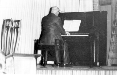 Surrey Hills Historical Society Collection
Photograph, Alan Judge Holt at the piano
His dates: 1913-1993. ‘Kenilworth’, 9 Beatrice Avenue was home of Edmund Holt, his wife and 3 sons Ray, Fred and Alan who attended Surrey Hills State School in their primary years. The family were very involved with the Methodist (Uniting) Church. Alan became organist and for some years also played at the Canterbury Presbyterian Church. He was well-liked from his days as a newspaper delivery boy, and after marriage lived at 62 Broughton Road and then 2 Earle Street taking part in various local activities with his wife Edna and three boys. After completing his secondary education at University High Alan joined the Public Service and after a time in the Premier’s Department moved to the Lands Department. He became Secretary of that department and after retirement moved to 13 Berry Street, Box Hill. He keenly researched the history of Surrey Hills. He left his collection of Surrey Hills history to the people of Surrey Hills. A black and white photograph of a man playing at a piono. He is dressed in a suit and has his back to us. There is a planter stand to the left of the photo.kenilworth, beatrice avenue, surrey hills, mr alan judge holt, lands department, organist, surrey hills methodist church, canterbury presbyterian church, mrs edna holt, broughton road, earle street, pianist -
 Brighton Historical Society
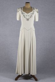
Clothing - Dress, Wedding dress, 1941
Worn by three brides in 1941, 1944 and 1948. The dress was made for Eva Elizabeth (Bid) Harvey for her marriage to Morris Langlo West on 2 October 1941 at St James Catholic Church, North Road, Gardenvale. They had two children, Julian (1942-2005) and Sr. Elizabeth West (born 1942). Bid was born in 1906 to Michael and Kitty Harvey. They lived at 51 Cole Street, Elwood. The bridesmaid was Bid's niece Jocelyn Hickey. The dress was also worn by Jocelyne Dorothy Taylor when she married John Carlisle (Carl) Harvey (Bid's brother) at James Catholic Church, Gardenvale on 30 June 1944. Jocelyne's bridesmaid was Jocelyn Hickey and the best man was Basil Robinson. The reception was held at 'Birdwood', Birdwood Avenue, Brighton. Jocelyne was born in Rangoon, Burma in 1921 and was the eldest daughter of Stanley and Dorothy Taylor. Carl was the only son of Michael and Kitty Harvey. Jocelyne and Carl lived at 15 Harwood Street, Elwood and later at 54 North Road, Brighton. They had five children, Michael, David, Jennifer, Robert and Eric. The third bride to wear the dress was Jocelyn Mary Hickey, who was bridesmaid to Bid and Jocelyne. Jocelyn Hickey was born in 1929 to Daniel and Doreen Hickey (Bid's sister and Jocelyne's sister-in-law). Jocelyn married Gerard Leslie O'Donnell at St James Catholic Church, Gardenvale in 1948. The bride's attendants were Adita Smith, Maureen Bow and Jacqueline Connell. The groom's attendants were Jack Fallon and Con O'Donnell. The reception was held at 51 Cole Street, Elwood. Jocelyn and Gerard had three daughters, Maree, Carlene and Janine. They lived in Bunyip, Victoria. (Information provided by the donor).Cream crepe wedding dress with short sleeves and dropped waist. Sweetheart neckline, bodice and sleeves decorated with floral design in bugle beads. Fastens with metal zip in left side seam.wedding dress, wartime bride, 1940s, eva elizabeth harvey, jocelyne dorothy taylor, jocelyn mary hickey -
 Surrey Hills Historical Society Collection
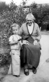
Photograph, Mary Selina Simpson, c1940
Mary Selina Inglefinger was born in 1856 in Kings Plain, NSW and was the eldest daughter of Joseph Inglefinger and his wife Maria Viktoria Bertel (Barthl), both of whom were born in Germany; they applied to come to Australia in 1854. They had 10 children, the first 8 born in Kings Plain. In 1879, Joseph Inglefinger bought James Staig's farm in Boundary (Warrigal) Road, near the corner of Bona Vista Avenue, Surrey Hills. The 1903 and 1905 electoral rolls list them in Boundary Road. In 1875 Mary married Charles Simpson, stepson of James Staig in Scots Church, Melbourne. They had 3 boys and 3 girls. This photograph was taken with her great-grandson in 1940.A black and white photograph of a lady sitting on a chair with a young toddler standing beside her.On back of photo: Mary Selina Simpson / (nee Inglefinger) / c.1940 / (born Mary Maghlina) / born c. 1857(miss) mary inglefinger, (mr) joseph inglefinger, (mr) james staig, warrigal road, surrey hills, bona vista avenue, (mrs) mary simpson, boundary road, (miss) mary maghlina inglefinger -
Friends of Ballarat Botanical Gardens History Group
Work on paper - Matilda L.Thompson (Tilly) nee Clennell, A Life of Service, 6/2009
Tilly Thompson, as she was usually known, will always be remembered for her service to the Ballarat community. Her Memorial Garden in the Ballarat Botanical Gardens is testimony to her substantial contribution. Tilly Thompson was an active member in charities in Ballarat and is closely associated with the Avenue of Honour and the Arch of Victory. 1 page and 2/3 printed. John Garner's name at the end of the article.None.matilda l. thompson, tilly thompson, tilly thompson garden, lucas factory, avenue of honour, arch of victory, tom toop curator, john garner collection, doctor john garner, ballarat botanical gardens, friends of ballarat botanical gardens, jubilee church, ballarat old cemetery, gardens, ballarat