Showing 248 items
matching counties of victoria
-
 Kew Historical Society Inc
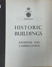
Book, Cumberland County Council, Historic Buildings: Liverpool and Campbelltown, 1963
[Liverpool, N.S.W.] : Cumberland County Council, 1963 54 p. : ill., maps ; 26 cm. non-fictionhistoric buildings -- new south wales -- liverpool., historic buildings -- new south wales -- campbelltown. -
 RMIT GSBL Justice Smith Collection
Report, Wright, Ted, Report on the miscellaneous causes caseflow management pilot project, 1992
... victoria. county court...County Court of Victoria... Russell Street Melbourne melbourne victoria. county court court ...With compliments slip attached by paperclip to outside of front cover: from His Honour Chief Judge Waldronvictoria. county court, court administration -- victoria -
RMIT GSBL Justice Smith Collection
Book, Butterworth & Company (Australia) Ltd, Practice of the County Court of Victoria : being an annotation of County Court act 1958, and the rules of court thereunder, Foreign judgments act 1962, Instruments act 1958, Imprisonment of fraudulent debtors act 1958, and Service and execution of process act 1901-1963 (Com.), 1965
... Practice of the County Court of Victoria : being an... of Victoria : being an annotation of County Court act 1958 ...Previous owner: T. H. SmithIncludes multiple loose-leaf amendments placed in appropriate placescourt rules -- victoria -
RMIT GSBL Justice Smith Collection
Book, CCH Australia Limited, Victoria civil procedure 1987, 1987
... victoria. county court... victoria. supreme court victoria. county court victoria ...Previous owner: T. H. SmithIndex includedISBN: 0869039326victoria. supreme court, victoria. county court, victoria. magistrates' courts, court rules -- victoria., civil procedure -- victoria -
RMIT GSBL Justice Smith Collection
Book, Victoria. Parliament. Law Reform Committee, De Novo appeals to the County Court : Law Reform Committee, 2006
... victoria. county court... Russell Street Melbourne melbourne victoria. county court ...ISBN: 0975798421victoria. county court, appellate procedure -- victoria, criminal procedure -- victoria, justice, administration of -- victoria -
RMIT GSBL Justice Smith Collection
Book, Cook, Richard et al, The annotated rules of court, 1996
... victoria. county court victoria. county court... victoria. county court victoria. county court victoria. magistrates ...ISBN: 0646287362victoria. supreme court, victoria. county court victoria. county court, victoria. magistrates' courts, court rules -- victoria., civil procedure -- victoria -
 Federation University Art Collection
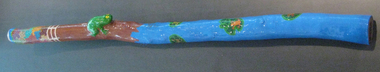
Artwork, other - Timber, acrylic paint, glass coat, beeswax, 'Frog Didgeridoo' by Peter Clarke, 2008
Peter CLARKE (1969- ) Gunditjamara (Lake Condah) Born Heywood, Victoria At two months old Peter Clarke was removed from his parents and placed in a Catholic boy's orphanage in Ballarat. The orphanage was closed and Peter was moved to a public orphanage where he discovered 'manners were not a necessity and you often had to take before you were ever given in this orphanage. ... This new orphanage was not a home for me but a prison of sadness and despair.' Disconnected from his country and lore Peter Clarke chose "my own path to land, county and water". Although his childhood memories are dark and bleak, he uses vibrant colours. This item is part of the Federation University Art Collection. The Art Collection features over 1000 works and was listed as a 'Ballarat Treasure' in 2007.Mallee Wood didgeridoo with vibrant colours. A natural wood imperfections have been used to emphasise what is recognisable as a frog. This work was purchased from the "My Art, My Life, My Colours' exhibition at the Federation University Post Office Gallery, May 2008.art, artwork, aboriginal, peter clarke, didgeridoo, stolen generation, st joseph's orphanage, sebastopol, my art, my life, my colours' exhibition, federation university post office gallery -
 Port Fairy Historical Society Museum and Archives
Photograph
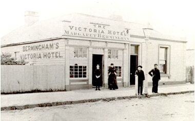
Thomas and Margaret Maria Bermingham came to Australia from County Kildare in 1854. By 1856 Thomas was doing business as a Shoemaker in a three roomed dwelling with workshop and garden in Bank street. The stone hotel building was erected in 1867, and named Bermingham’s Victoria Hotel where he conducted the business with his wife. Thomas Bermingham died suddenly in 1874 only 48 years old. His wife continued to run the hotel until 1901. It was not unusual for women to run hotels at this time, although they had to be widowed To be granted a license.. John Maloney took up the license but the hotel closed in 1909. The building still stands and has been renovated Photograph of a building in Bank Street possibly the late 1800'sBlack and white photograph of weatherboard building with two multi panel windows 2 females and 2 males on footpathhotel, building, bermingham, bank street, john maloney -
 Port Fairy Historical Society Museum and Archives
Photograph
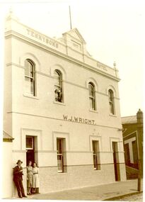
The small building on the left is the Farmers Inn, and was built about 1849, when James Brown became the first licensee. In 1854 John Walwyn Taylor moved from the Sally Ann to take over, and remained there until 1857, when he moved to his new hotel The Star of the West built on the old Sally Ann site. John Wall then became the new licensee of the Farmers Inn. In 1876 his wife Bridget made an application for the license to be transferred to her as “her husband suffered from rheumatism, and there were certain other reasons why the license should be transferred to her hands”. The Bench wondered about creating a precedence of granting a license to a married woman, who was living with her husband, (licenses were only granted to the widows of licensees at that time), so the application was postponed for 14 days, but eventually Mrs Wall won her case. In 1882 Patrick Tennyson took over the lease of the Farmer’s Inn and applied to change the name to Tennyson’s Hotel. In 1885 he bought the freehold in the Great Land Sale for £780. 12s. 8d., and in December, carried out extensive renovations. The local press reported that “the rooms were quite tasteful, the Billiard room commodious and well ventilated, and that the old hotel had not looked so good for years”. The double storied part of the hotel was added in 1893. Patrick Tennyson had a colourful career. He was born in Charlemont, County Armagh in 1846. When he was 21, he served as a papal guard at the Vatican for 2 years and then entered the Marist Brothers novitiate in Beauchamps. In 1872 he was one of three brothers to accompany Brother Ludovic to Sydney; he was then aged 23. After 5 years he withdrew from the Congregation and moved to Victoria, where he took up teaching, first at Rosedale near Sale, then at Crossley, by which time he was married to Anne White. They had eight children, three dying in infancy. Eight months after he took over the Farmers’ Inn, he was elected to the Borough Council, and served as Mayor in 1897. His great interest was sport, was Secretary of the Race Club for 20 years and supported the local Football Club by donating a silver cup for local competitions. Patrick Tennyson died in 1904. The hotel continued under various licensees until it burned down in 1977 under the name of “The Fishermen’s Arms”. Well known main street hotel no longer exists Sepia photograph of 2 story building with tiled wainscoting male and 2 females in doorway and 2 females in window upstairshotel, building, sackville street, patrick tennyson, w.j.wright -
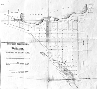 Friends of Ballarat Botanical Gardens History Group
Work on paper - Suburban Allotments (west of) Ballaarat, Wendouree or Yuille's Swamp, County of Grenville 30/4/1856, 30/4/1856. No date given for photocopy
This map of the 1856 survey shows the numbered suburban allotments and the boundaries surrounding this area including Wendouree or Yuilles's Swamp close to where the Ballarat Botanical Gardens and the Lake exist today. This map gives a clear idea of an early survey of this western area and directions to areas of Ballarat surrounding these allotments.2 pages of the same map, except p.2 shows the Township Reserve on the lefthand side of the page. On the back of p.2, righthand corner is the Public Records Stamp.P2, righthand corner is the citation in pencil.john garner, doctor john garner, ballarat botanical gardens, friends of ballarat botanical gardens, map of western suburban allotments 1856, county of grenville, public record office of victoria, john garner collection, gardens, ballarat -
 Falls Creek Historical Society
Plan - Leases of part of Falls Creek Tourist Area
Bob (Herman) Hymans (a former member of the Royal Netherlands Navy was born in Bloemendaal, Holland on 30th September 1922. During World War II he fought against the Japanese in the Dutch East Indies (now Indonesia) and was imprisoned in Changi and on the Burma Railway. After gaining qualifications as a Ski Instructor, Bob arrived in Falls Creek in May 1950. Working as an Instructor and Supervisor at Bogong Lodge, Bob decided his future was in accommodation. He was successful in negotiating an indenture for land from the State Electricity Commission (SEC). It took Bob two years to build his Grande Coeur Chalet but, tragically, it was burned down in August 1961. Bob also built the first Chairlift in Australia. This was a single chairlift and the structure was built from wooden electricity poles. He was constantly full of new ideas and proposals for the village. Bob Hymans died on 7th May 2007. This Collection of documents and letters tells the story of Bob’s endeavours to develop Falls Creek into the ski village it is today. This map is significant because it documents boundaries of early leases in Falls Creek Tourist Area.This map is part of Bob Hymans documents. It is a large Surveyor's Plan of a section of the Falls Creek Tourist Area. It is endorsed by J Parker, Chief Surveyor of the State Electricity Commission of Victoria on 27-3-84. It shows streets, lot numbers and measurements. It was a compilation created from existing lease maps. Heading - PART OF FALLS CREEK TOURIST AREA PART OF CROWN ALLOTMENT 1 PARISH OF CARRUNO PART OF CROWN ALLOTMENT 1 PARISH OF DARBALANG COUNTY OF BOGONGmap of falls creek, falls creek leases, falls creek 1980s -
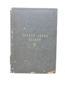 Kilmore Historical Society
COUNTY COURT DIGEST, Charles F. Maxwell, 1888
Digest of Cases, explanatory of the County Court Statute, 1869 to October 1879.Brown cloth-bound hardcover book, loss of cloth bottom front & spine extremities, faded. Discolouration of back & front flyleaves. Binding a little loose. 122 pp. Fair condition.Inside frond cover, sticker, ' J. Powceby/Book Binder/Little Collins St. East/Melbourne'. Front flyleaf, stamp, 'LAW DEPARTMENT/VICTORIA'. county courts, kilmore court house library. -
 Maldon Museum and Archives Association
The Apple Book, September 1949
This portfolio was created in response to a gift of apples from the Maldon district community in Central Victoria Australia to the children of Maldon Essex in the post World War II period. It was created for presentation to the Maldon Primary School by their UK counterpart, in gratitude, and as a symbol of cultural and political bonds. For some years before we received it the portfolio was kept in inappropriate storage and suffered some damage, and parts of it seem to have been removed. Nevertheless it is a fascinating and heartwarming document, which casts a light on the United Kingdom of the late 1940s. It is commonly known as "The Apple Book".The portfolio comprises 52 pages with various items affixed. These may be typed pages, photographs of places and people (including many small portraits), and artworks on paper and fabric. A cover is formed by heavy cardboard, covered with paper, with a hinge made near the left side and a heavy cord used to hold it all together.There are no inscriptions or labels, but the heraldic crest of Maldon Essex is reproduced on the front cover.maldon essex, maldon victoria, world war ii, apple -
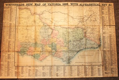 Wodonga & District Historical Society Inc
Map - Whiteheads New Map of Victoria, E. Whitehead & Co., engravers & lithographers, 1868
... A detailed early map of Victoria with counties clearly... A detailed early map of Victoria with counties clearly marked ...Edward Whitehead was a printer and publisher active in Melbourne during the latter half of the 19th century. Whitehead founded his printing business at 67 Collins Street East in 1864 and, though not focused on maps, began publishing his own series of maps of Victoria in 1867. He focussed on producing highly detailed folding maps of Victoria which included a very detailed index of place names. His series of maps of Victoria became one of the most successful and most profitable series of regional maps of Australia ever produced.This is a very early map of Victoria showing Belvoir (Wodonga)A detailed early map of Victoria with counties clearly marked and shaded and a detailed index. It also shows roads, post office towns, railways, telegraphs, gold mining areas and notes on topography. Relief shown by hachures and spot heights. Includes a list of towns with distances from Melbourne on 3 sides of map. It is produced on paper mounted on linen.victoria cartography, rare maps victoria, whiteheads maps -
 Wodonga & District Historical Society Inc
Map - Tulloch & Brown's Map of the Colony of Victoria, Tulloch & Brown, 1856
The map was created by Tulloch and Brown. David Tulloch was one of the earliest engravers and lithographers in the state of Victoria. He arrived in Melbourne from Greenock, Scotland, on 3 January 1849. Following the discovery of gold Tulloch went to the Victorian goldfields in 1851, commissioned to make sketches of the diggers and the diggings for Ham’s Illustrated Australian Magazine. In November 1852 Tulloch set up in business as engraver, draughtsman, copperplate printer and lithographer. Tulloch took a map engraver, James Davie Brown, into partnership in March 1853; the several maps and specimens of commercial engraving they showed at the 1854 Melbourne Exhibition were awarded a bronze medal. That year Tulloch and Brown also received a silver medal at the Victorian Industrial Exhibition. The partnership was dissolved towards the end of 1856.This is a very early map of the Colony of Victoria including Belvoir (now know as Wodonga).A foldable map mounted on linen and with a board cover. It records the Colony of Victoria according to Surveyor's Records revised in 1857. Areas of the map are shaded to highlight different counties.At bottom right hand section of map: Tulloch & Brown's map of the Colony of Victoria : comprising part of New South Wales, the boundaries, counties, also seaport & inland townships, the gold fields with the latest discoveries, roads, tracks, &c. &c. / compiled from drawings in the Survey Office and correctly revised till 1857. Respectfully dedicated by Permission, to the Honorable Captain Andrew Clarke R.E. Surveyor General of Victoria by His Obediant Servants Tulloch & Brown, Engravers & Publishers, Melbourne". At bottom right below border : Published as the Act directs by the Proprietors, Melbourne, 1st Feb. 1856. tulloch and brown maps, rare maps victoria, victorian cartography -
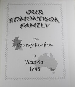 Wodonga & District Historical Society Inc
Book - Our Edmondson Family - from County Renfrew to Victoria 1848, Rob Mortlock, Bob Polkinghorne, Lorna Polkinghorne
... Our Edmondson Family - from County Renfrew to Victoria 1848...Our Edmondson Family - from County Renfrew to Victoria 1848... County Renfrew to Victoria 1848 Book Our Edmondson Family - from ...This history of the Edmondson family begins with the journey of George and Isabella Edmondson, with their four children, from County Renfrew via Liverpool to Melbourne in 1848. After some time at the Bendigo goldfields, George and his second wife, Margaret Boyd, moved to the Yackandandah area. Later family members settled in various areas of Victoria, with one descendant, Ern Edmondson being a member of the ANZAC forces. Particular mention is made of Maud Cadman, an octogenarian family member, and source of much family information. The story is profusely illustrated with photographs of family members, and, in particular, a photograph of a New Testament, presented to Margaret Boyd aboard the ship that brought her to Australia in 1852.non-fictionThis history of the Edmondson family begins with the journey of George and Isabella Edmondson, with their four children, from County Renfrew via Liverpool to Melbourne in 1848. After some time at the Bendigo goldfields, George and his second wife, Margaret Boyd, moved to the Yackandandah area. Later family members settled in various areas of Victoria, with one descendant, Ern Edmondson being a member of the ANZAC forces. Particular mention is made of Maud Cadman, an octogenarian family member, and source of much family information. The story is profusely illustrated with photographs of family members, and, in particular, a photograph of a New Testament, presented to Margaret Boyd aboard the ship that brought her to Australia in 1852.edmondson family, pioneers, beechworth, yackandandah, northeast victoria family history -
 Bendigo Historical Society Inc.
Administrative record - Great Columbian Mining Company Minute Book 1904-1911, 1906
Dark green hardcover register, buff binding on spine and corners, two hundred and seventy pages. 'Minute Book' written in gold print on spine of book. Written in blue pen on inside front page: ' The Great Columbian Mining Company No Liability' Minutes entered date from 30th March 1904 to 6th September 1911. Minutes signed by James Hedley. Documents inserted in minute book, additional to minute content: 1. List of unpresented cheques (no date on list) 2. Petition by John William Allen, Manager, Bank of Victoria, View Street, Bendigo to 'wind up' the Great Columbian Mining Co. Dated 18th September, 1911. 3. From Great Columbian Mining Co., Inglewood, Butler and Sons account 4. List of Great Columbian Mining Company N.L. shareholders 5. Mine Manager's Report half year ending 6th September 1911 6. Directors' Report, 6th September 1911 7. Two letters from Fred. Douglas Jones, Barrister and Solicitor, Albion Chambers, Bendigo regarding cheques 'being returned unpaid' by Bank 8. Judgement from County Court Bendigo, 19th September, 1911, against the Great Columbian Mining Company, defendant. Plaintiffs, George Victor Lansell; George Wooten Lansell and Richard Hartley Smith Abbott 9. McColl and Rankin, Legal Managers, Accountants, invoice to Great Columbian Mining Co., 31st December 1911. 10. Letter, J. Stagg, Inglewood to McColl and Rankin, re settling up of accounts for the Great Columbian Mining Co., Inglewood 11. Great Columbian liquidation, Ingleoowd, Feb 19th. 1912 to R.A. Rankin Esq., re sale catalogue articles. Enclosed Mr. Butters charge for hire of horse and dray ((not in book) Signed J. Cavanaugh 12. Invoice from McColl and Rankin to the Great Columbian Co., for cash advances, 31st December 1912 13. Great Columbian Mining Co., statement of having received 'one receiver and mountings in good condition' signed McCulloch Carrying co., L. Lee, 5/2/12 14. Account Richard Linton, Manufacturers Agent, Queen Bridge Square, Melbourne to Great Columbian Mining Co., Inglewoodbendigo, mccoll and rankin, margaret roberts, great columbian mining company, inglewood, -
 Whitehorse Historical Society Inc.
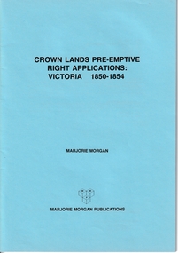
Administrative record - Crown Land Valuations and Applications, Government Printer - John FERRES, Crown Lands Pre-emptive Right Applications: Victoria 1850-1854, 1855
Contains a valuation for Crown Lands applications under pre-emptive right by Victorian county, giving names of applicants name of run, area, and remarks.Contains a valuation for Crown Lands applications under pre-emptive right by Victorian county, giving names of applicants name of run, area, and remarks. Contains a valuation for Crown Lands applications under pre-emptive right by Victorian county, giving names of applicants name of run, area, and remarks. clarke andrew, anglesey, evelyn, bourke, dalhousie, dundas, follett, grant, hampden, heytesbury, normanby, polwarth, ripon, talbot, villiers, district of murray, district of wimmera, district of western port, early settlement, mornington -
 Bendigo Historical Society Inc.
Document - LANDS OFFICE, REPORTS OF SALES BY PUBLIC AUCTION, 1864 - 1892
... of sales of crown lands by public auction Act 25, Victoria 145... Act 25, Victoria 145. Alphabetical index of counties inside ...Document: buff leather hard covered journal. On spine on red rectangle ' Land sales by public auction' written in gold. On bottom of spine 'Lands and Survey' written in gold on black. On base of spine '4' printed in black. Pages contain details of sales of crown lands by public auction Act 25, Victoria 145. Alphabetical index of counties inside front cover. 443 numbered pages. LH side columns, number, county, parish, section, allotment sold, unsold, price. RH page - improvements, purchaser, residence, amount, later sales have printed notices pasted in. Dated 27 April 1864 to 7 October 1892.Lands and Survey Dept.place, bendigo, sandhurst, crown land, public land auctions, land sales. -
 Bacchus Marsh & District Historical Society
Map, Village allotments, Parish of Myrniong, County of Bourke
Myrniong is a village 9 kilometers west of Bacchus Marsh. Prior to 1863 the area was known as Blow's Flat. This map which was produced in 1903 and according to the catalogue record of this map held at the State Library of Victoria was based on an earlier map created in 1861. The early layout of streets for the village of Myrniong can be seen on this map. The streets shown are, Main Street, Hardy Street, Blow Street, Myrniong Street, Shuter Street, and Blackwood Street. An area marked as a reserve for a school can be seen between Hardy Street and Main Street.A single page paper map. A cadastral parish map of Myrniong in Victoria, showing numbered land allotments. Photo-lithographed at the Department of Lands & Survey, Melbourne, in 1903. Based on an original map created in 1861. The map is pasted into a bound volume containing 76 maps or plans in total. High resolution digital image stored on BMDHS computer network. Surveyed by John Hardy, Surveyor ; photo-lithographed at the Department of Lands & Survey, Melbourne by T.F. McGauran, 24.12.03myrniong parish plan, myrniong parish maps -
 Bacchus Marsh & District Historical Society
Map, Gorrockburkchap Parish Map, County of Grant c.1906
The parish of Gorrockburkchap (sometimes spelled Gorrockburkghap) lies to the west and south west of the township of Bacchus Marsh. The locality of Rowsley is situated within this parish area.A single page paper map showing the parish plan for Gorrockburkchap in the County of Grant. A cadastral map showing parish boundaries and land ownership The map is pasted into a bound volume containing 76 maps or plans in total. High resolution digital image stored on BMDHS computer network. gorrockburkchap parish maps, rowsley victoria maps, bacchus marsh region parish plans -
Lakes Entrance Historical Society
Book, Stevens M I, Township of Cann River, Parish of Noorinbee, County of Croajingolong, 1977
An account of the development of the Cann River town and district in Gippsland, Victoria, compiled for the 50th. anniversary of the Cann River school. Includes list of pupils and head teachers, information on other schools, and recollections of residents.settlers, schools, township -
 Bacchus Marsh & District Historical Society
Map, Parish of Yangardook, County of Bourke 1876
The parish of Yangardook lies directly north of the township of Melton. The locality of Toolern Vale lies in the centre of this parish. A single page paper map showing the plan for the Parish of Yangardook in the in the County of Bourke. Scale 40 chains to 1 inch. The map is pasted into a bound volume containing 76 maps or plans in total. High resolution digital image stored on BMDHS computer network. Photo lithographed at the Department of Lands and Survey, Melbourne by J. Noone, 1.8.76yangardook parish maps, toolern vale victoria maps -
 Ringwood and District Historical Society
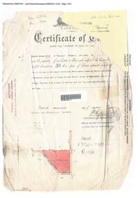
Document, Certificate of Title - Edward Thomas Miles, Gentleman, "Woorara", Ringwood - part of Crown Section 20, Parish of Warrandyte, County of Evelyn - 1913
A4 copies of damaged Landata Victoria Historical Search documents - Vol 3726 Fol 200 - incomplete proprietor and transfer details.Edward Thomas Miles is now the proprietor of an Estate in Fee-simple subject to the Encumbrances notified hereunder ... 27 acres 19 perches or thereabouts, together with a right of carriage way over roads coloured brown. Subdivision map includes un-named roads - western side is Wonga Road (later Warranwood Road), and eastern side is Grandview Grove (later Bemboka Road), both north of Plymouth Road, Ringwood, Vic. Transfers include (illegible) Dobbs, November, 1927 - 5 acres Harry Temple Marshall, 1st December, 1928 - 10ac 3r David Edward Meyland, 4th October, 194-? (illegible). -
 Ringwood and District Historical Society
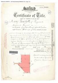
Document, Certificate of Title - Mary Burchett, Lilydale Road, Ringwood - part of Crown Section 20, Parish of Warrandyte, County of Evelyn - 5th July, 1911
A4 copies of Landata Victoria Historical Search documents - Vol 3520 Fol 703990.Mary Burchett of Ringwood, Married Woman, is now the proprietor of an Estate in Fee-simple subject to the Encumbrances notified hereunder ... 50 acres 1 rood 32 perches or thereabouts, being lots 1 and 10 on plan of subdivision no.4315. Subdivision map includes un-named roads - western side is Wonga Road (later Warranwood Road), and eastern side is Grandview Grove (later Bemboka Road), both north of Plymouth Road, Ringwood, Vic. Title transferred to Theodore Hartley Burchett, 27th July, 1911. Encumbrance comment "Special railway condition contained in Grant to Francis Cooke." -
 Ringwood and District Historical Society
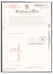
Document, Certificate of Title 1977 and Subdivision Plan 1999 - 21-23 Bemboka Road Warranwood, Victoria
A4 copies of Landata Victoria Historical Search documents. Certificate of Title Vol 9217 Fol 041 Church of England Trusts Corporation For The Diocese Of Melbourne - part of Crown Section 20, Parish of Warrandyte, County of Evelyn, 7th June, 1977. Includes Plan of Subdivision , postal address Bemboka Road, Warranwood 3134 (north of Lyric Court), certified under Subdivision Act 1988, 8/2/1999. -
 Eltham District Historical Society Inc
Document - Map, Victoria. Department of Crown Lands and Survey, Town of Eltham, Parish of Nillumbik, County of Evelyn, 2 October 1929
... , Parish of Nillumbik, County of Evelyn Document Map Victoria ...Township of Eltham, Parish of Nillumbik, County of Evelyn / lithographed at the Department of Lands & Survey Melbourne 5th June 1888, amended 2 October 1929 This amendment from the 1888 original shows the reserve for the the State School marked as permanent with dimensions added to Main Road and block frontages along Main Road between Mount Pleasant Road and Dalton Street and Metery Road Possibly photocopied from a copy held at PROV by Harry Gilham whilst resaerching Eltham Primary School history in 1995.a. armstrong, a. lavard, arthur c. allan, arthur c. allen, b. bowatere, baxter street, benjamin oliver wallis, bolton steet, c. souter, c.s. hain, cemetery reserve, charles brown, charles newman, charles symons wingrove, christopher caldwell, church of england, d. anderson, dalton street, david ballard, e. james, e.m. peck, edward dumaresq, eltham town, ely street, f.e. falkiner, f.m. peck, falkiner street, flint street, g. buckingham, g. drabble, george stebbing, godalmin street, h. peck, h.c.whess, h.h. farquharson, h.j. bews, henry stooke, j. goer, j. mcdonald, j. mclaren, j. roberts, j.b. knagers, james irish, jane bailey (nee matthews), john l. smith, john mason, john scott, john smith, joseph stevenson, joseph verse, k. wingrove, k.e. dunstan, kerby street, kirby street, location tbd, m. coman, map, michael o'shea, o.b. mccutcheon, p. & g. tumbull, p.k. mccaughan, p.p. cotter, porter street, pound reserve, robert hepburn, roman catholic church, s. evans, samuel dagley, samuel phillips, samuel ramsden, t. upton, t. watkins, t.a. stark, t.c.b. batt, t.p. cross, thomas grant, thornton street, w. adam, w. blain, w. long, w. watkins, w.f. ford, w.h. hull, w.r. belcher, w.t. schultz, william thomas, eltham primary school, eltham state school, eltham state school no. 209, quarry reserve -
 Bendigo Historical Society Inc.
Document - LANDS OFFICE: SALE OF CROWN LANDS BY PUBLIC AUCTION, 25/5/1898 - 26/8/1915
Journal: green hard cover journal with brown spine and corners. LH page: lot, county, town or parish, section, allotment, extent, why not sold, upset price per acre, sold for per acre. RH page: value of improvements, name of purchaser, residence, deposit forfeited, total amount. Contains details of sales by public auction across Victoria.Lands Officecrown lands public auction, lands office, crown lands, public auction., sandhurst -
 Bendigo Historical Society Inc.
Document - LANDS OFFICE - SALE OF CROWN LAND BY AUCTION, 1892 - 1920
Document: dark green hard cover journal with buff spine and corners. Contains details of public auctions of crown lands in fee simple at various locations in northern Victoria. Printed details of auctions pasted for each sale. LH page: lot, county, parish, section, allotment, sold, unsold, why not sold, upset price, sold for. RH page: value of improvements if any, name of purchaser, residence, deposit forfeited, total amount.Lands Officelands office, crown lands, auction, northern victoria -
![Map, Plan of Subdivision [Allotments along Lerderderg, George and McFarland Streets]](/media/collectors/5e461d8021ea67224c82f2a1/items/675d7243165f146b8adfc656/item-media/675d72d7165f146b8adfc859/item-fit-380x285.jpg) Bacchus Marsh & District Historical Society
Bacchus Marsh & District Historical SocietyMap, Plan of Subdivision [Allotments along Lerderderg, George and McFarland Streets]
This map shows allotments of land on the northern side of Lerderderg Street from Gisborne Road through to the approximate site of the present day Bacchus Marsh Primary School. There are also allotments shown on the southern side of McFarland Street between George Street and Gisborne Road. Larger allotments of land are shown extending northwards towards Masons Lane. Inscribed at the top of the map are the words, 'Plan of Subdivision of Cr Pors (Crown Portions) 12 & 13 & Allotments 1,2,3,4, Block 3, Parish of Korkuperrimul, County of Bourke'. The date of the map has not been established but the absence of the Bacchus Marsh Primary School on the map suggests it may have been produced prior to 1865 when the primary school was built in Lerderderg Street.Single page map showing house block size land allotments in the Lerderderg, George Street and McFarland Street area of Bacchus Marsh with larger allotments north of this area towards Masons Lane also shown. Scale 150 feet to 1 inch. Part of a set of maps which are pasted into a bound volume containing 76 maps or plans in total. High resolution digital image stored on BMDHS computer network. bacchus marsh victoria maps, lerderderg street land allotments, mcfarland street land allotments