Showing 752 items matching "farm house"
-
 Orbost & District Historical Society
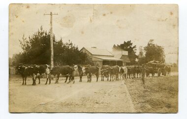
black and white photograph, 1911
This photo shows Jas Lynn of Orbost driving a team of bullocks pulling a large cart of maize. They are taking it to the fisherman's Wharf in Lakes Entrance. Maize has been grown on the Orbost flats since the late 19th century. Transport was always an obstacle to economic sucess. For a few years prior to the First World War and the construction of the railway line from Bairnsdale to Orbost, a lot of maize was carted by horse and bullock teams to Lakes Entrance for transhipment to the Melbourne market. At that .time yields of 90 to 100 bushels of maize were quite a common occurrence. James Lynn, a member of the East Gippsland Maize Board, farmed at Jarrahmond.This photograph is associated with the large maize growing industry in the Orbost region. A black / white photograph of a bullock team pulling a large, loaded cart. It is being driven by a man standing on the side of the road, holding a whip. In the background are houses and a telegraph pole.on back - " Carting maize to Lakes Entrance in 1911."transport-bullocks maize-orbost lynn-james -
 Orbost & District Historical Society
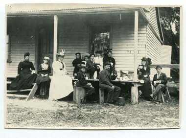
black and white photograph, Green, O. S, April 1897
This photograph shows the Richardson family having a picnic on the verandah of Captain McNeil' house at Marlo - April 1897. Snowy River Shipping Company formed in 1880. They were soon shipping produce (mainly vegetables) from the area to Melbourne. The Snowy River Shipping Company was formed by Mr Henry James during the 1880s, with Captain McNeil as master. Captain Hegarty was the shipping agent at Marlo. Towing a line of small barges these paddle steamers plied their trade between the port of Marlo, and the farms along the river banks, churning their way almost twenty miles upstream to a landing beside what is now Frank Richardson’s property. On these trips, the barges carried mail and supplies to the townspeople and farmers, loading their produce, mostly maize, on the return trip to the coast. The coming of the railway in 1915 spelt the end for the little river boats. ( ref. F. W. RODWELL in the “Snowy Review”) Frank Richardson 1877-1950 was a sawmiller at Tabbara and helped build and run paddle steamer "Curlip"as engineer. Captain McNeil was an always cheerful Marlo identity and local children had many times sailing with him on the river. Captain McNeil with tug went out through the entrance and brought in the schooners.This item is associated with the Richardson family, early settlers of the Orbost district.A black / white photograph of a group of people having afternoon tea on the end of a verandah of a wooden house. All are seated.on back - " The Richardson family picnic at Marlo"richardson-family-orbost-marlo mcneil-captain -
 Orbost & District Historical Society
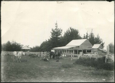
black and white photograph, first half 20th century
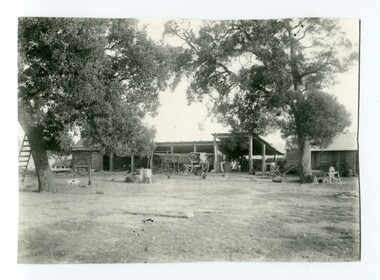
Mr John Watt set up farming in 1879. He was a native of Port Fairy. He was educated in Scotland and came back to Victoria and selected 320 acres on the Snowy River.The property extended from Majors Creek Road to around about Gilbert's Gulch.This is associated with John Watt, a prominent early settler in Orbost.A black / white photograph of a dilapidated farm shed with three horses in the foreground. A house can be seen in the background (left) behind a fence. on back - "Watts Farm"watt-john-orbost farming-buildings -
 Orbost & District Historical Society
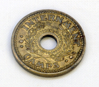
coin, Arendsen & Sons, WW11
For security reasons, tokens were used in Australian WW11 Internment Camps. They were introduced in 19433 to replace the paper canteen coupons. This token was used at the internment camp at Bete Bolong just outside Orbost during WW11. This camp was established in 1943 and was there until 1946. The internees had been transferred from the camp at Murchison East to provide farm labour. The coin was given to Lindsay Thomson when he was a student.This token was used at the Bete Bolong POW camp from 1943-1945. This camp housed Italian POWs, some of whom remained/returned after the war to settle in Orbost.An internment camp coin. This is a one penny coin token with a hole in the centre. It is made of brass.ONE PENNY INTERNMENT CAMPStoken ww11 bete-bolong internment-camp -
 Ringwood and District Historical Society
Map - Public Land Sale by Thomas Ham, 2000 Acres for Sale - Crown Sections 20, 23, 24 - Ringwood, Victoria - 1855
Two 1850s surveyor's maps on cardboard backing showing area from Melbourne extending East beyond Bulleen and Nunawading. Detailed description of lots for sale and navigational directions to the property from Richmond by Thomas Ham, Victorian public servant, map maker, publisher, lithographer and original Ringwood land owner. Inset map enlarging area between Yarra River and Dandenong Creek, with southern boundary of allotments later forming part of Oban Road, North Ringwood.TRANSCRIPT: "This really valuable Property is now offered to the public for sale, in lots to suit purchasers at the Iow rate of £1 per Acre for 80 acres and upwards, and £1.10s per Acre for any smaller portion. Terms of payment Half Cash, Balance in 6 and 12 months, bearing 8 per cent interest. The Estate is well wooded with Gum, Cherry Tree and Stringy Bark, with Wattle in the valleys of the several creeks. Every lot is Staked and Trenched at the corners marked on the Plan thus - The Surveyor has carefully sub-divided the Property, in order to give every Farm a Creek for Water, Valley for Cultivation, and Hills for House and Grass Paddock. The ROADS have been very carefully laid out so as to give a firm, well drained, and nearly level road to each Homestead. Intending purchasers can readily find the property by the following directions, viz: Start from Richmond Bridge, at Hawthorne, then take the left-hand road to KEW. When at the "Woodman Inn", take the Cotham Road to the right, bearing due east, keep this Road, passing Trainor's "White Horse" Inn, and before you leave the fences, you will see calico bills (see margin) nailed to the Trees on the bush track leading to the Upper Yarra country, follow the Bills till you come to the SOUTH boundary line of the Property, which bears East and West (see Plan) where you will see Bills nailed up "THIS PROPERTY FOR SALE, etc." The Bills from Town lead direct to where Mr. Jull is erecting his Store, and arrangements have been made with him to show the lots to intending purchasers free of charge. At the respective corners of the lots the Bills are nailed up double, with numbers to denote the lot, and that the corner stake is adjacent. Any parties wishing to proceed to the property by way of BULLEEN will find Bills nailed on the Trees, commencing at the NEW INN, at "Wilson's Slip Rail." Keep this Track till you come to the Log Bridge, over the Deep Creek at Bloxhome's Paddock; go through the land now being cleared; keep the track over the hill till you come to an Iron House, you will then be on the property, which Iies to the North and East as per Plan. Follow the Bills till you come to Mr. Jull's Store, etc. etc. Further particulars can be had from the Agent for the Property. THOMAS HAM. " -
 Phillip Island and District Historical Society Inc.
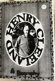
Booklet, Henry Cleeland - a biography
Henry [Harry ] is the son of John Blake and Ethel May Cleeland. He farmed near Surf Beach estate and lived at Woolamai House.HistoricalPhotocopy of a 9 page booklet of writing and photos on Henry Cleeland and family by Jessica WalshHenry Cleeland a biography by Jessica Walshhenry cleeland, woolamai house, world war 2 lifestyle -
 Phillip Island and District Historical Society Inc.
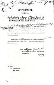
Document, Grant to W.J.McHaffie for lease of Crown land
J D McHaffie, Phillip Island's first leaseholder, relate how McHaffie set up his headquarters (and later built his house) alongside what is now known as McHaffies lagoon. The McHaffie brothers – John David and William – occupied Phillip Island under a license from the Admiralty in 1842 and farmed it as a sheep run.Historical3 A4 photocopies showing application for lease in 1850, size and description of the land and instructions for the application.w.j.mchaffie, land grant, farming, saltwater creek, crown land -
 Orbost & District Historical Society
black and white photograph, early 20th century
Mr John Watt set up farming in 1879. He was a native of Port Fairy. He was educated in Scotland and came back to Victoria and selected 320 acres on the Snowy River.The property extended from Majors Creek Road to around about Gilbert's Gulch.The Watt family settled in Orbost as farmers being one of the first farming families in the district.A black / white photograph showing wooden farm sheds and wagons. a small wooden house is on the right hand side and there are tall trees in the fioreground.on back - Mrs Watts farmwatt- farm agriculture-buildings -
 Orbost & District Historical Society
black and white photograph, early 20th century
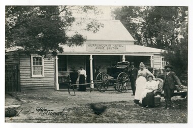
This photograph shows Pike's buggy with Joe Pike, Mrs George Pike, Annie Bruton and Maggie Middleditch on the verandah. Annie Bruton was the wife of Jack Bruton who came to Orbost about 1891. When land was made available for selection at Murrungowar. they took up a selection and embarked in dairying, sheep-farming and pig-raising. They transformed a veritable wilderness into a productive farm by sheer hard work and liberal expenditure. By 1892 he had secured a licence for an hotel and accommodation house, store and the first post office at Murrungowar. For a time she was licensee of the Murrungowar Hotel. In December 1897 he was living at Murrungowar when he made application for a Roadside Victualler’s License for a house situated at Boulder Creek, East Gippsland, containing four rooms in course of erection, exclusive of those required for family. He was a butcher at Orbost in 1902-03 and also had a farm on the Bendoc Road. He was a member of the first Golf committee. After leasing the hotel to Jonson's he moved to Orbost and started brick-making near the Orbost water service basin on the Bendoc Road. He had the order for the bricks required for the Masonic Hall. Mr and Mrs Bruton resided at Murrungowar for 29 years. They let their property to Messrs McDONALD and sons and retired to Orbost in December 1920. Mr Bruton had not been in very good health for the last 4 or 5 years of his life, and about a fortnight prior to his death he got wet at his brick kiln, and contracted pneumonia which led to hiThis is a pictorial record of the the Murrungowar Township which was once a thriving settlement with a hotel, store, post office and school. In the 1890s pioneers were attracted to the area with the promise of a railway from Orbost. However, when the promised railway did not eventuate most of the farms were abandoned. Much of the previously cleared areas have reverted to Forest. Most of the remaining farms are now privately owned eucalypt plantations.A large black / white photograph of five people standing outside a one - storey wooden building. There is an empty buggy behind them with a horse behind it. The building has a sign above the verandah - "MURRUNGOWAR HOTEL ANNIE BRUTON".on front - "Pikes Buggy - Mrs Bruton, Mrs Geo & Mr Joe Pike" ; Herbert Sherwood photographer murrungowar-hotel bruton-annie pike-joe -
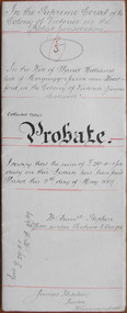 Warrnambool and District Historical Society Inc.
Document - David Williams Probate 1889, 1889
Tait collection: item 36 of 62 This document contains the details of the Will and Probate of David Williams of ‘Morgrugyn’ farm near Woodford. He was born in 1804 and died in 1889. He was a pioneer settler in the Woodford area, arriving, according to the Pioneer Honour Board, in 1842. His son, Ivor, was Secretary of the Grasmere Cheese and Butter Factory for some time and Secretary of the Warrnambool Cheese and Butter Factory in 1888. David Williams left real estate to the value of £1540 and personal estate to the value of £1075. The chief beneficiary was his eldest son, David but other sons and grandsons also benefited. His wife, Mary, was left £300, a house to live in rent free during her lifetime, two cows and the right to graze them on the farm, six silver spoons, her bed and bedding, washstand and ware, a dressing table, a table in the dairy and ‘all the crockery and cooking utensils she may require’. The lawyer drawing up this document was James Fletcher who had an office in Port Fairy in the 1870s and an office in Koroit Street, Warrnambool, in the 1880s. In the 1890s and early 1900s he was in partnership with George Mackay. This document was in the possession of the lawyer Ernest Chambers who had drawn up the Williams will. It was then passed down to successive lawyers occupying legal premises in Kepler Street until it was located in 2014 in the Kepler Street building last used as legal premises by the firm of Mackay Taylor. This document is of considerable interest as it contains the will and probate details of a prominent 19th century farmer in the Woodford district. It will be useful for researchers.This is a white piece of parchment paper folded in two with typed material on two pages and handwritten material on one page. The pages are ruled with red ink. The pages include the Will and Probate details of David Williams of ‘Morgrugyn’ farm near Woodford. He died in 1889.In the Supreme Court in the Colony of Victoria in the Probate Jurisdiction In the Will of David Williams Morgrugyn farm near Woodford in the Colony of Victoria Farmer deceasedjames fletcher, david williams, ernest chambers, warrnambool, woodford, morgrugyn farm -
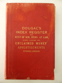 Warrnambool and District Historical Society Inc.
Book, Dougaln Index Register to NOK, Early 20th century
This book belonged to James and Catherine McGinness (both names are in the book). James McGinness (1842-1905) came to the Framlingham area in the 1870s and married Catherine Taafe in 1880. Members of the McGinness families had been involved in hotelkeeping in the Purnim district. James and Catherine McGinness had a farm at Framlingham (including the breeding of horses) with the property known as Riverview. The farm and derelict remnants of the house still exist today. The youngest son of James and Catherine was Paul McGinness, a hero of two World Wars and the founder of the airline Qantas. The original spelling of the surname was ‘McGuinness’ but James altered the spelling to avoid confusion over names with his brother John. This book is of interest because it belonged to the McGinness family of Riverview, Framlingham. Several of the names in the book are marked, especially those of ‘McGuinness’ showing that perhaps the McGinness family of Framlingham had expectations of claiming some of the money listed as unclaimed. This is a hard cover book of 472 pages. At the back of the book are several pages giving addresses of lawyers and opinions of the Press. The cover is red with an embedded pattern on the front cover and gold lettering on the front cover and the spine. The inscriptions are handwritten in blue and black ink. The book contains names of those deceased persons and/or their heirs who have appeared in advertisements regarding unclaimed money. There are several coloured insert sheets in the book with copies of letters of thanks sent by grateful readers. The cover is very stained and torn at the edges. ‘C. McGinness Framlingham’ ‘James McGinness Framlingham’ james and catherine mcginness, paul mcginness, history of framlingham, history of warrnambool -
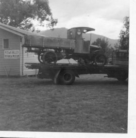
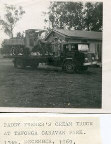 Kiewa Valley Historical Society
Photo - Paddy Fisher's Cream Truck 1969, December 13, 1969
The Hallford truck was made by J & E Hall, of Dartford, England, whose business commenced in 1785. In 1926 the Fisher family of Mongan's Bridge took delivery of the 1923 Hallford truck which was used on the farm to transport cream to the Kiewa Butter Factory in Tangambalanga. In 1967, the truck was sold to Mr Greg Bedstead and other members of the Kiewa Valley Historical Society for the KVHS who reimbursed them at a later date. The truck was housed at the Butter Factory for many years and was paraded on special occasions. The truck was purchased for $380. It's chassis no. 2439 and the price included a spare chain. (Ref. E. Fisher on 18th Dec. 1969) The KVHS group who paid $50 each towards the Hallford truck were: T Pyle; James Grave; P & E. Barton; K Shoebridge; K Plenderleith and SK Pearce.refunded in 1971 Hallford truck. Fisher family. Kiewa butter factory. J & E Hall Company of England. E FisherBlack and white photograph of Paddy Fisher's cream truck loaded onto a tray truck at the Tawonga Caravan Park. Seven unidentified people on the tray truckSmall typed note attached to back of photo 'Paddy Fisher's cream truck at Tawonga caravan park. 13th December, 1969hallford truck, cream truck, fisher family, kiewa valley farmers, mongan's bridge -
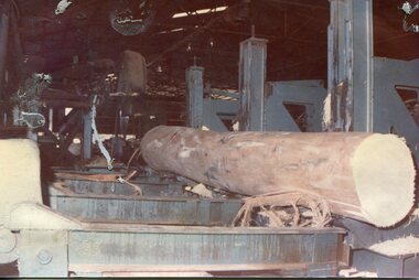
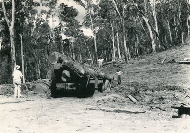 Kiewa Valley Historical Society
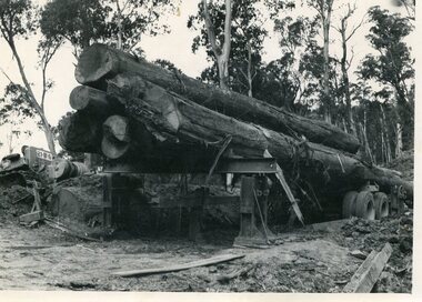
Photo - Mountain Creek Logging Camp, 1955
Hume and Hovell discovered the area in 1824 and by the end of the 19th century the valley was transformed by logging, dairy and beef cattle properties and tobacco farms. The logs could have been milled for timber at the State Electricity Commission's mill at Howman's Gap which provided a much needed source of timber for construction of McKay Creek Power Station which began construction in 1951 and also the camps and houses for the workers and their families. There was a need for housing and infrastructure for an increasing population of workers for the hydro-electric scheme as there was a general shortage of this commodity. A timber mill was started in Tawonga by Mates, of Albury, in 1945, and electricity became available in 1946 the S.E.C. bought the mill, and enlarged it. In 1960 it was purchase by a local family, they also started a timber mill in Mt Beauty worked both until 1980 when they closed it. The Tawonga mill and enlarged the mill called Mt. Beauty Timbers Pty Ltd employed approximately 50 people. An historical pictorial record of the general working conditions, type of machinery and vehicles in use in the 1950’s. Note the lack of protective clothing!Black and white photograph of the logging camp at Mountain Creek. November 1955Handwritten on the back of photograph - MOUNTAIN CREEK LOGGING CAMP NOV 55mountain creek logging camp, timber industry, tawonga -
 Kiewa Valley Historical Society
Photo - Logging. Mountain Creek, November 1955, November 1955
Hume and Hovell discovered the area in 1824 and by the end of the 19th century the valley was transformed by logging, dairy and beef cattle properties and tobacco farms. The logs could have been milled for timber at the State Electricity Commission's mill at Howman's Gap which provided a much needed source of timber for construction of McKay Creek Power Station which began construction in 1951 and also the camps and houses for the workers and their families. There was a need for housing and infrastructure for an increasing population of workers for the hydro-electric scheme as there was a general shortage of this commodity. A timber mill was started in Tawonga by Mates, of Albury, in 1945, and electricity became available in 1946 the S.E.C. bought the mill, and enlarged it. In 1960 it was purchase by a local family, they also started a timber mill in Mt Beauty worked both until 1980 when they closed it. The Tawonga mill and enlarged the mill called Mt. Beauty Timbers Pty Ltd employed approximately 50 people An historical pictorial record of the general working conditions, type of machinery and vehicles in use in the 1950’s. Black and white photograph of logging at Mountain Creek November 1955Small typed note attached to the back of photo - Logging Mountain Creek November 1955mountain creek logging camp, tawonga, timber industry -
 Kiewa Valley Historical Society
Photograph - Mt Beauty timber Industries, 1960's (estimate only)
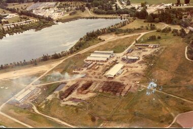
Hume and Hovell discovered the area in 1824 and by the end of the 19th century the valley was transformed by logging, dairy and beef cattle properties and tobacco farms. Timber was required for construction of McKay Creek Power Station which began construction in 1951 and also the camps and houses for the workers and their families. There was a need for housing and infrastructure for an increasing population of workers for the hydro-electric scheme as there was a general shortage of this commodity. A timber mill was started in Tawonga by Mates, of Albury, in 1945, and electricity became available in 1946 the S.E.C. bought the mill, and enlarged it. In 1960 it was purchase by a local family. They also started a timber mill in Mt Beauty and worked both until 1980 when they closed the Tawonga mill and enlarged the mill called Mt. Beauty Timbers Pty Ltd which employed approximately 50 people. A pictorial record of the development of the Mt Beauty community and the local timber industry.Colour photograph of aerial view of Mt Beauty Timber Mills and surrounding area including pondage and part of airfield. Photo taken in 1960’s (estimate only)Handwritten in ink on back of photograph in very faint writing – Recent photo of Mt Beauty Timber Industries Mt Beauty Operationsmt beauty timber industry, timber industry, timber mill, secv -
 Kiewa Valley Historical Society
Photograph - Mount Beauty Timber Industries, 1960's (estimate only)
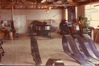
Hume and Hovell discovered the area in 1824 and by the end of the 19th century the valley was transformed by logging, dairy and beef cattle properties and tobacco farms. Timber was required for construction of McKay Creek Power Station which began construction in 1951 and also the camps and houses for the workers and their families. There was a need for housing and infrastructure for an increasing population of workers for the hydro-electric scheme as there was a general shortage of this commodity. A timber mill was started in Tawonga by Mates, of Albury, in 1945, and electricity became available in 1946 the S.E.C. bought the mill, and enlarged it. In 1960 it was purchase by a local family. They also started a timber mill in Mt Beauty and worked both until 1980 when they closed the Tawonga mill and enlarged the mill called Mt. Beauty Timbers Pty Ltd which employed approximately 50 people. A pictorial record of the development of the local timber industry in the Kiewa Valley showing equipment used in timber milling.Colour photograph of Mt Beauty Timber Industries Mill. Photo taken inside the workshop showing saw blades and equipmentmt beauty, mt beauty timber industry, timber mill -
 Kiewa Valley Historical Society
Photographs x 2- Halford truck, 1. 11/7/1972 2. Unknown
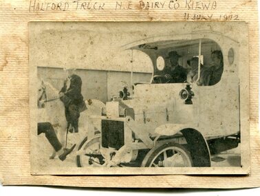
The Hallford truck was made by J & E Hall, of Dartford, England, whose business commenced in 1785. In 1926 the Fisher family of Mongan's Bridge took delivery of the 1923 Hallford truck which was used on the farm to transport cream to the Kiewa Butter Factory in Tangambalanga. In 1967, the truck was sold to Mr Greg Bedstead and other members of the Kiewa Valley Historical Society for the KVHS who reimbursed them at a later date. The truck was housed at the Butter Factory for many years and was paraded on special occasions.This truck was used to transport cream to the Kiewa Butter Factory from the Fisher family's dairy farm at Mongan's Bridge. At other times a tyre was removed and a belt attached to run a chaff cutter. This truck has historical significance as it is presentative of vehicles which were used by farmers to transport cream to the butter factories by a local family. Furthermore, it has social significance as KVHS members combined their finances to purchase this truck so it would be part of our collection. It is well provenanced and has an excellent interpretive capacity.2 black and white photographs mounted on buff card 1. Photograph of Halford truck with man on white horse riding alongside. Presumably in a parade. Dated 11th July, 1972 when truck was no longer in service. 2. Photograph of Halford truck followed by a horse and buggy. Date unknown1. Handwritten in black ink above photo 'Halford truck N.E. Dairy Co. Kiewa. 11 July, 1972' 2. No markingshallford truck, fisher family, kiewa valley farmers, dairy truck -
 Kiewa Valley Historical Society
Photograph- Paddy Fisher's truck at Tawonga, 13th Dec. 1969
The Hallford truck was made by J & E Hall, of Dartford, England, whose business commenced in 1785. In 1926 the Fisher family of Mongan's Bridge took delivery of the 1923 Hallford truck which was used on the farm to transport cream to the Kiewa Butter Factory in Tangambalanga. In 1967, the truck was sold to Mr Greg Bedstead and other members of the Kiewa Valley Historical Society for the KVHS who reimbursed them at a later date. The truck was housed at the Butter Factory for many years and was paraded on special occasions. Photograph shows truck parked outside the original Kiewa Valley Historical Museum which was located at Tawonga Caravan Park and was later relocated to its current location at the Mt Beauty Information Centre. This truck was used to transport cream to the Kiewa Butter Factory from the Fisher family's dairy farm at Mongan's Bridge. At other times a tyre was removed and a belt attached to run a chaff cutter. This truck has historical significance as it is presentative of vehicles which were used by farmers to transport cream to the butter factories by a local family. Furthermore, it has social significance as KVHS members combined their finances to purchase this truck so it would be part of our collection. It is well provenanced and has an excellent interpretive capacity.Black and white photograph of Paddy Fisher's truck on a flat bed truck, outside the original Kiewa Valley Historical MuseumSmall typed tag on back of photo 'Paddy fisher's truck taken at Tawonga Caravan Park 13th December, 1969'hallford truck, fisher family, kiewa valley farmers, mongan's bridge, cream truck -
 Kiewa Valley Historical Society
Photographs - 2 Colour photographs of logs being harvested and milled for timber in the Kiewa Valley
: Hume and Hovell discovered the area in 1824 and by the end of the 19th century the Kiewa Valley was transformed by logging, dairy and beef cattle properties and tobacco farms. The logs could have been milled for timber at the State Electricity Commission's mill at Howman's Gap which provided a much needed source of timber for construction of McKay Creek Power Station which began construction in 1951 and also the camps and houses for the workers and their families There was a need for housing and infrastructure for an increasing population of workers for the hydro-electric scheme as there was a general shortage of this commodity. A timber mill was started in Tawonga by Mates, of Albury, in 1945, and electricity became available in 1946 the S.E.C. bought the mill, and enlarged it. In 1960 it was purchase by a local family, they also started a timber mill in Mt Beauty worked both until 1980 when they closed the Tawonga mill and enlarged the mill called Mt. Beauty Timbers Pty Ltd which employed approximately 50 people. An historical pictorial record of the type of machinery and vehicles in use in the 1950’s to harvest and mill the logs from surrounding forested areas.1. Colour photograph of large logs being milled for timber at a timber mill 2. Colour photograph of heavy machinery being used to harvest large logs for milling timber; timber mill; kiewa valley; forests; logging -
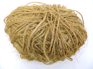 Kiewa Valley Historical Society
Tobacco Tying Twine
Tobacco farming began circa 1960 in the Kiewa Valley and consequently became one of its major industries. Many of the Italian families were involved in tobacco farming.Historical: This equipment was used on one of the first tobacco farms in the Kiewa Valley at Mongans Bridge. Provenance: This tobacco farmer came from Italy and was sponsored to visit a tobacco farmer in Myrtleford to learn how to grow tobacco so that he could transfer those skills to his own farm in the Kiewa Valley.The twine was used to tie green leaf in bunches onto the sticks. There were 26 bunches per stick and 500 sticks per kiln. Spool of tying cotton used on electric sewing machine. With the bailing, the sewing needles were housed on a hook on the top edge (of the tying horse) with the correct length of string at hand - time was of the essence. A large ball of orange, scratchy, twine kept together by a piece of twine wrapped around it.tobacco. mongans bridge. kiewa valley. twine. tying horse. -
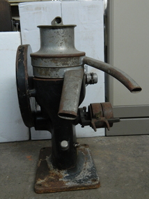 Kiewa Valley Historical Society
Cream Separator
Dairy farms used cream separators to separate the milk and the cream before using it themselves or selling it to the dairy companies, shops or directly to the public.This cream separator was used by P & R Creamer on their dairy farm in the Kiewa Valley.3 parts - top brass lid with hollow cylinder enclosed across its top and extending beyond its circumference. 2. Stainless Steel hollow cylinders that fit the base and the lid but has 2 long curved spouts extending out - one for the milk and one for the cream to come out 3. Black cast iron stand that houses the gear mechanisms that drive the separator cones. The gear speed reduction wheel is on one side. "Alfa-Laval MOB / 80 Gall Capacity per hr / 48 Rev of Crank per Minute / Alfa-Laval Separator / Co. Ltd / 299 Sussex St. / Sydney" - on bottom side of the machinedairy; cream separator; kiewa valley; creamer family -
 Christ Church Anglican Parish of Warrnambool
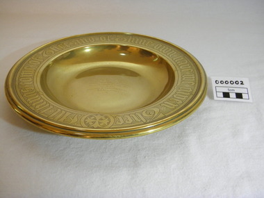
Plate, Untitled, Brass Alms dish, C.1902
Brass Collection Plate presented to St Paul's Anglican Church, Allansford, by the mother of Joseph & Frank Dallimore as a Memorial to the two brothers who drowned at Ryan's Den (near Cape Otway) on Jan 1st 1903. Major Joseph Dallimore (aged 32) was on leave from Sth Africa during the war and he, his wife (Beatrice Wiggs) and baby, his brother Frank Rupert Dallimore (aged 22), a farm hand Arthur Geach (aged 19) and a house maid servant, were picnicing at Ryan's Den (near Cape Otway) when the three men went walking, but never returned, all assumed drowned. One theary has it - Mrs M.E. Dallimore was picnicing at Lake Gillear beach when an enormous wave swept over the shore - (much larger than any other during that day) and rolled in all along the beach. This wave may have also reached the area where the three men were walking on the rocks and swept them into the ocean. Only one body was recovered - some 4 weeks later - that of Frank Rupert Dallimore and washed into Brown's Creek, 1 mile from the Johanna River and ten miles east of Ryans Den.It is a memorial plate and records the family's attachment and importance to the Church.Brass engraved and embossed Memorial Collection PlateEmbossed wording around edge of plate in Old English font reads - "All things come of Thee and of Thine own have we given Thee". The inscription on the tondo of the plate reads - "TO THE GLORY OF GOD / AND IN MEMORY OF / JOSEPH & FRANK RUPERT DALLIMORE, / WHO WERE DROWNED AT RYAN'S DEN, / JAN 1ST 1903. / PRESENTED BY THEIR LOVING MOTHER, / M.E.DALLIMORE."brass st pauls anglican church allansford warrnambool church of england christ church parish of warrnambool collection plate memorial plate dallimore drowning ryan s den alms dish -
 Warrnambool and District Historical Society Inc.
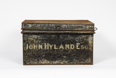
Container - Metal Tin for holding documents, late 19th century
This tin or trunk came from the old Kepler Street, Warrnambol Tait legal offices. The tin originally held legal documents connected to John Hyland (1830-1908). Irish-born John Hyland came to the Warrnambool district in 1850 working as a mounted trooper and a rate collector. He then farmed in the Mortlake district for some years before returning to Warrnambool and setting up as an auctioneer and stock and station agent. He was a Warrnambool Councillor (1880s and 90s) and Mayor (1891-2). His trunk of legal documents was first held by the lawyer, Henry Parrington, operating in Warrnambool from 1888 to 1917 (1888-1900 Higgins and Parrington, 1900 Parrington and Tait, 1901-1917 Parrington). Following Hyland's death in 1908 Henry Parrington has used the tin to house his probate documents and when John Sym Tait purchased the Parrington practice in 1917 he has obviously taken over the Hyland trunk. This tin is of some considerable interest as a memento of past Warrnambool identities - John Hyland and Henry ParringtonThis is a metal tin, rectangular in shape. It has a ridged top, two metal handles and a key mechanism.John Hyland Esq. Parrington Probates & Deeds (keep)henry parrington warrnambool lawyer, john hyland warrnambool, john sym tait warrnambool lawyer -
 Warrnambool and District Historical Society Inc.
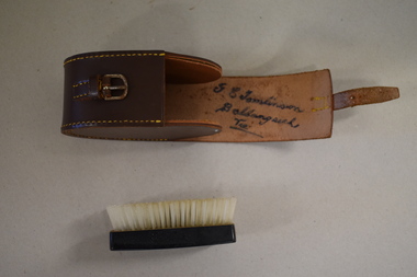
Clothes brush & holder, Mid 20th century
The brush in this case could have been used as a hair brush or a clothes brush. It is enclosed in a leather case and was probably an item made for travellers. The brush and case belonged to George Tomlinson of Ballangeich. Ballangeich is a small settlement on the Hopkins Highway about 27 kilometres from Warrambool. George Tomlinson’s grandfather, William Tomlinson , established a farming property at Ballangeich in 1865 and opened a hotel, ‘Half Way House’ on part of the land. George Tomlinson’s father, also William, continued to farm in the area and was known as a fine judge of cattle and sheep. This case and brush are of interest as an example of the brushes men used in the mid 20th century. The items are also of interest as they belonged to a member of a well-known Ballangeich family (Tomlinsons).1 This is a piece of brown leather rolled over and stitched with yellow thread to form a container or case. The case has a closing mechanism – a leather strap and metal buckle. .2 Inside the leather case is a brush with a brown Bakelite back with horsehair inserted. ‘G.E. Tomlinson Ballangeich Victoria’men’s toiletries, ballangeich, history of warrnambool -
 Eltham District Historical Society Inc
Photograph (Item) - Print, Karen Hynes, The House With Half A Red Roof, 1988
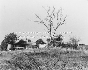
... Series 35 Scan - 35mm negative Fabbro's farm Karen Hynes West ...Original West family home, Fabbro's farm, Bell Street, Eltham Karen Hynes 1988 Entrant No. 10 No negative SHIRE OF ELTHAM COMMUNITY PHOTOGRAPHIC SURVEY Photography is an artform which many of us practice, sometimes purely for artistic pursuit, sometimes to record the people and events in our lives. In 1988, as part of a local Bicentennial project, the Shire of Eltham conducted the Eltham Community Photographic Survey. Up to 100 entries were to be selected by a panel of photographers for entry into the Eltham Photographic Survey Exhibition. Entries had to be submitted by May 13, 1988. Entrants whose images were selected for the exhibition were contacted and requested to further submit an entry form providing entrant’s name, area of residence, age, and proposed captions. These details were then used to produce labels for the exhibition mounts. Where negatives had not been supplied, these were requested to support the display of printed enlargements mounted on 10” x 8” cardboard. The mounted prints were made available post exhibition for sale at $8.50 each for colour prints and $7.00 for B&W prints. Residents in the Shire were invited to collect a free roll of film and take a photograph of what they either liked or did not like about the area. A total of 160 entrants submitted multiple entries for the exhibition. Of those selected for exhibition, entrants ranged in age from 9 to 70 years. All custom colour and black and white printing for the exhibition was completed by Wattle Studios of Eltham. The Eltham Photographic Survey was jointly auspiced by the Shire of Eltham and Wattle Studios, of 953 Main Road, Eltham. The project was greatly assisted by: • David McRitchie, Media Studies Lecturer Victoria College, Rusden Campus. • Ian and Annette Toohill of Wattle Studios • Tracy Naughton, Eltham Community Arts Officer • Neville Emerson Pty. Ltd. • Superior Press, Eltham • Kodak Australasia Pty. Ltd. • Agfa Gevaert Ltd. • Townsend Colourtech Pty. Ltd. • The Australian Bicentennial Authority • Eleanor Bowers, Secretary, Eltham Arts Council The exhibition was placed on display in the Woolworths Arcade, Eltham between Monday June 6th and Saturday June 11, 1988. It was also intended to hold the exhibition at a venue in the Shire’s North Riding from Monday, June 20 to Friday June 24. It was then displayed at the Were Street Theatre, Montmorency from Friday, June 24 to Thursday, July 7. Series 34: Eltham Community Photographic Survey 1988 - Prints & Documentation Series consists of 117 photographs of Shire scenes taken by members of the community. Items I - 41 are larger photographs mounted on card, which were exhibited. Items 42 - 117 are unmounted copies, alternative takes and other entries. Corresponding negatives contained in Series 35: Eltham Community Photographic Survey 1988 – Negatives which consists of 267 colour and B&W negatives and one colour slide of Shire scenes taken by members of the community. The negatives are arranged by the entrant number of the photographer. The Eltham Community Photographic Survey collection is significant to the local community as it was curated by the local community - ordinary people of all ages - representing what they liked and did not like in the area where they lived. It represents an unfiltered representation of the Shire of Eltham as it was in 1988. It also represents one of many projects as part of the national programme of events and celebrations to commemorate the bicentenary. It is a time capsule of life in the 1980s of this urban and rural municipality in Melbourne's north. Front: Entrant No. and name on printed label Rear: Entrant No., name and address on printed label; also 'Series 34' and the 'Item No.' in pencilshire of eltham archives, bicentennial project, eltham, eltham community photographic survey, eltham photographic survey exhibition, series 34, series 35, scan - 35mm negative, fabbro's farm, karen hynes, west house -
 Eltham District Historical Society Inc
Film - Video (DVD), Nillumbik Shire Council, Edendale Farm Community Environment Centre: History, c.2009
EDENDALE FARM Edendale Farm is Nillumbik Shire Council's environment centre situated in Gastons Road, Eltham between the railway and the Diamond Creek. The homestead on the property was built in 1896 and is of historical significance, being the subject of a Heritage Overlay under the Nillumbik Planning Scheme. The Edendale property was originally part of an extensive land purchase in 1852 from the Crown by pioneer Eltham farmer Henry Stooke. He initially purchased 51 acres and later expanded his holdings by purchasing another three adjacent Crown allotments extending northerly from Josiah Holloway's Little Eltham subdivision. Despite clearing the land, Stooke did not build on this property, choosing to live on his property "Rosehill" at Lower Plenty. In 1896 Thomas Cool, Club Manager of the Victoria Coffee Palace in Melbourne purchased 7 acres of the original Stooke land and built the house now known as Edendale. Cool did not farm the land, instead using it as a gentleman’s residence, retiring to Eltham at weekends. In 1918 he purchased an additional 7 acres but in 1919 he sold the property. Later owners included J.W. Cox, the Gaston family and D. Mummery. In the 1980s the Eltham Shire Council purchased the site for use as a Council depot, but this use did not proceed. Subsequently, it was used as the Council pound. The Edendale Farm Pet Education and Retention Centre was established in the summer of 1988/1989 and was set up to replace the existing dog kennels with a high standard pet retention centre. The design style of the building was established to compliment the features of the existing house. It was equipped with 10 retention pens, a veterinary room and a pet education area where school children and other interested parties learnt about pet care procedures. It was later developed into a community farm and was run by an advisory committee and in 2000 it became an Environment Centre. In early 2006 an advisory committee was established for the development of a master plan for future development at Edendale Farm. The committee included Russell Yeoman, a former long-time shire planner and founding member of the Eltham District Historical Society. At the time of filming the Master Plan and future for Edendale was about continuing to develop Edendale as a centre of environment learning and looking at expanding displays and school program, running a lot more of life-long learning and workshops around sustainable living.edendale community farm, eltham, gastons homestead, gastons road, shire of nillumbik, video recording -
 Eltham District Historical Society Inc
Document - Folder, Mann, John and Violet and family
John Mann arrived from Forfar, Scotland, on the clipper packet "Ellen Stuart" in 1857 and rented a farm "Overton" at Janefield. Soon after he met Melbourne-born Violet McKimmie, whose parents had a property near Darebin Creek. They married on 25 September 1862, John 26 and Violet 19. In 1874 John selected a block on Arthurs Creek and built a slab and bark hut (still standing in 1984) and called their farm "Carseburn" after John's parish in Scotland. They had seven children: John, Jane, Christine, David, Walter, James and Violet. John was drowned in the Yarra in May 1875 and Violet struggled to meet the lease commitment. She wrote to her brother-in-law David Mann in New Zealand who came to her aid, and on 10 September 1876, they married at the Victorian Free church, Smith Street, Collingwood. They improved the farm and built a three-room house. in July 1883 they bought neighbouring land from Ann Welsh. With David, Violet had four more children: Robert, William and twins Thomas and Henry. In 1883, David died and was buried in the same grave as his brother in Preston Cemetery. The twins also died, Thomas just before and Henry just after their father. the children assisted with the farm and orchard, the business including crops, a dairy herd, Carseburne sheep, and breeding horses. Violet died at Yan Yean in 1925, aged 83. A grandson of John Mann, James Mann, lived in Henry Street, Greensborough and had given a talk at the Whittlesea Historical Society in 1983 on his family. Descendant Lindsay Mann was part of a creative writing group that published a book including a short story "The Mountain Tramway" is loosely based on his childhood and stories he was told then but was planning to write his family story. Contents Newspaper article: "Tragedy couldn't stop this pioneer", Diamond Valley News, 31 January 1984, story of Mann family. Newspaper article: "Tracing the history of ordinary. people," Diamond Valley News, 29 July 1986, story of Mann family, researched by descendant Lindsay Mann who grew up at the Mann property She-Oak at Yan Yean and has numerous family records. Newspaper article: "A realist who captures light," Diamond Valley News, 29 July 1986, David Moore, a realist painter had been working from a studio at Montsalvat and his exhibition of work from that period was to open 1 August 1986 at the Victorian Artists Society Galleries.Newspaper clippings, A4 photocopies, etcjohn manan, violet mann nee mckimmie, clipper packet "ellen stuart", forfar scotland, darebin creek victoria, arthurs creek victoria, "overton" at janefield, "carseburn" at arthurs creek, jane mann, christine mann, david mann, walter mann, james mann, violet mann, victorian free church smith street collingwood, ann welsh, robert mann, william mann, thomas mann, henry mann, preston cemetery, carseburne sheep, yan yean cemetery, lindsay mann, david moore, montsalvat -
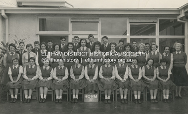 Eltham District Historical Society Inc
Photograph, Classic Photos, Form 3A, Eltham High School, 1960
Dr Gary Presland advised the following in October 2020: "In 1959 my parents bought a house in Church Street, Panton Hill. For about three and a half years previously, they had farmed a property 15 km south of Echuca, before moving, briefly to Melbourne. After moving to Panton Hill, I was enrolled at Eltham HS, in Form 2 (Year 8). I completed that year, and in 1960 was in Form 3A (at which time the photograph was taken). To reach the school, I caught a bus each day, from Panton Hill. Early in 1960, my parents decided to separate. My mother left with the youngest two of my three siblings, leaving me and a younger brother with our father in Panton Hill. My brother was in Year 7 at the High School. After a few months, my father and I had a falling out and my brother and I left home to join our mother in South Melbourne. For the remainder of the 1960 school year we travelled each day by train from Melbourne to Eltham. In 1961 I was enrolled at Melbourne Boys High School, which was the nearest secondary school to where I was then living."Written in pencil on back: "Gary Presland - 4th from left, back row Eltham HS, 1960" Also stamped in purple ink on back "Classic Photos"1960, class photo, eltham high school, gary presland -
 Eltham District Historical Society Inc
Photograph, Peter Pidgeon, Grave of John and Mary Murray, Eltham Cemetery, Victoria, 5 April 2021
Irish-born John Murray and his wife Mary (daughter of Thomas Sweeney) married in 1849 and settled in Eltham North. John and Mary were amongst the earliest inhabitants of Eltham. John was a farmer and their block of about 80 acres, called ‘Laurel Hill’, was on the eastern side of the Diamond Creek, extending east to beyond Zig Zag Road. It was later extended southward by the purchase of a further 60 acres. He is recorded as a supporter on the petition for a school in Eltham and he served on the National School Board of the Eltham school. John died in 1867 and is buried in Eltham Cemetery with Mary and with two of their grandchildren. Their eldest son Johnnie inherited the property. Then in about 1902 his younger brother James purchased about 50 acres on the western side of the Diamond Creek immediately opposite Laurel Hill, extending west to slightly past Wattletree Road. Eltham North Reserve now lies just beyond the southern boundary. James built a family home on top of the hill on the northern boundary, together with a dairy and milking shed and a food cellar. It is thought that the barn with stables was already there. When Johnnie died in 1912, the two properties (though severed by both the creek and the railway line) effectively merged. The land was worked as an orchard with apples, pears, quinces, and possibly apricots and peaches. Later it became a dairy farm. By 1986, almost all the land had been sold off for residential subdivision and the house had been condemned as unfit for habitation. John's grandson Jim retained a small portion of the land and built a new house. He kept the old one as a storage shed, but it was demolished after he died in 1993. The very old barn is still standing. Located in the Roman Catholic section In Memory of John Murray Who died Dec. 1867 aged 50 years Also his wife Mary Murray Who died 7th Sep. 1909 aged 76 years And of their grandchildren Thomas and Mary Ellen DrainBorn Digitaleltham cemetery, gravestones, john murray, mary ellen drain, mary murray, thomas drain -
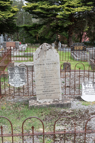 Eltham District Historical Society Inc
Photograph, Peter Pidgeon, Graves of Thomas Sweeney and family, Eltham Cemetery, Victoria, 5 April 2021
Irish-born Thomas Sweeney is regarded as the first settler in Eltham. He was transported to Sydney in 1823 after being convicted of arson. He was granted his freedom in 1838 and married Margaret Meehan in the same year. They moved to Melbourne and in 1842 Thomas purchased 110 acres beside the Yarra River in the vicinity of present-day Sweeneys Lane. He called the property ‘Culla Hill’ and built a small slab hut (reputedly with Wurundjeri help; Margaret is said to have run an informal hospital for them in return). This was followed in 1846 by more substantial buildings consisting of a three-roomed Irish-style ‘longhouse’ and a barn made of stone and handmade bricks, with doors large enough to accommodate a fully loaded wagon. When the gold rush came, Thomas prospered by selling meat and potatoes to the prospectors, enabling him to purchase a further 308 acres in 1856. He promoted the construction of a bridge over the Plenty River and the establishment of a school at Eltham. Roman Catholic Church services were held at Culla Hill in the early years. When he died in 1867, he was regarded as a respected member of the community. Thomas and Margaret are buried in Eltham Cemetery with many of their descendants. Their first son John continued to farm Culla Hill until his death in 1909. Culla Hill passed out of the Sweeneys' possession in 1939. The house and barn remain today, though lesser outbuildings have gone. The facade of the house is much the same as it was in the 1840s. Sacred To the memory of Thomas Sweeney Who died Sep 6th 1867 Aged 65 years May his soul res in peace Also his wife Margaret Died Oct 3rd 1884 aged 73 years And their daughters Annie Died Aug 22nd 1860 aged 21 years Johanna Died Aug 19th 1872 aged 22 years Margaret Died 7th Sep 1913 aged 72 years R.I.P. Also In Memory Of John Sweeney Died 24th May 1909 Aged 65 years Also of his wife Ellen Died 8th March 1910 Aged 64 years R.I.P Also In Memory Of Caroline Infant daughter of John & Ellen SweeneyBorn Digitalannie sweeney, eltham cemetery, gravestones, johanna sweeney, john murray, margaret sweeney, mary ellen drain, mary murray, thomas drain, thomas sweeney