Showing 217 items
matching house demolitions
-
 Ballarat Tramway Museum
Photograph - Colour Photograph/s, Alan Bradley, Nov. 1993
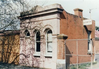
Set of three colour photographs of buildings and demolition of the former ESCo / SECV Wendouree Parade Power station sent to the Editor of Trolley Wire - used in the November 1997 issue of Trolley Wire. All photos by Alan Bradley. Photos taken during November 1993 or March 1994. All photos on AGFA paper. 1140.1 - The gate house building in Wendouree Parade - Nov. 1993 - used on page 21 of Nov. 1997 Trolley Wire. 1140.2 - Foundation stone - 23/8/1904 - of the ESCo power house. Gives names of people involved and contractors etc. - used on page 20 of Trolley Wire. Taken during November 1993. 1140.3 - Demolition work well advanced showing foundations and basement areas of power station - taken during March 1994. Used on page 25 of Trolley Wire. Hi res image of i2 added 16-12-2015. All have yellow stickers with photo number for magazine printer, and white sticky labels with photo number and words "same size" written on black ink. 1140.1 and 1140.2 have pencil cropping marks.trolley wire, esco, power station, demolition -
 Ballarat Tramway Museum
Photograph - Colour Photograph/s - set of 6, Warren Doubleday, 31/10/1994 12:00:00 AM
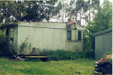
Yields information about the preparations for the recovery and move of tram body 21 to Newstead and the people involved.Series of six colour prints of the recovery and subsequent move of the body of Ballarat ESCo 21 from Daylesford to Newstead, 10/1994. Photographs by Warren Doubleday .1 - House with tram, after the start of the demolition by the owner, but prior to BTM work - 29/10/2004? .2 - ditto .3 - ditto .4 - after completion of the demolition and ready for lift by the BTM - 31/10/2004 .5 - fitting the intermediate supports .6 - with both 121 and 21 ready for unloading at Newstead. (Note other photographs of the move published in March 1995 Fares Please!) btm, tramcar bodies, tramcar preservation, newstead, tram 21 -
 Queenscliffe Maritime Museum
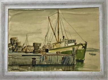
Painting - Framed Watercolour, Fishermen's Pier Queenscliff
Queenscliff’s first pier, then known as the Fishermen’s Pier, was completed in 1857. It was not until some thirty years later that the second Steamer Pier was constructed adjacent to the former and periodically extended from the mid to late 1880s to cope with the demand in pleasure bay steamer services. The last of these extensions was to provide a dog-leg construction and the extant shelter shed. 1960 witnessed the demolition of the original Fishermen’s Pier - by this time having been extended in the late nineteenth and early twentieth centuries to the equivalent length of the Steamer Pier - and saw the relocation of its 1926-29 lifeboat house to the Steamer Pier, now Queenscliff Pier. The mid to late 2000s saw Queenscliff Harbour undergo large-scale redevelopment in order to deepen its waters for pleasure craft and increase its berths to over 300. This was met with strong community opposition, largely with concerns for neighbourhood character and perceived cause for gentrification its stakeholders would impart. With early construction estimates of $20 million dollars, this figure had almost doubled upon realisation. (Lovell Chen Architects. ‘Individual Property Citation’, Queenscliffe Heritage Study, 2009.) (Freya Mitchell, ‘Queenscliff residents fight a tide of development sweeping the historic town’ ABC radio, 15 April 2005).Fishermen's Pier Watercolour painting of Fishermen's Pier in Queenscliffwatercolour, fishermen's pier, queenscliff -
 Bendigo Historical Society Inc.
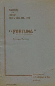
Document - IAN DYETT COLLECTION: AUCTION CATALOGUE - FORTUNA
Bluish catalogue with gold print on the front cover for a Demolition Auction Sale of Fortuna Under Instructions from Bendigo Mines No Liability on the 29th and 30th June, 1938. J. H. Curnow & Son were the Auctioneers.For sale were out buildings, household items, garden plants, skirting boards and floors. Catalogue has a black and white photo of Fortuna taken from the other side of the lake.business, auctioneers, j h curnow & son pty ltd, ian dyett collection - auction catalogue - fortuna, j h curnow & son, cambridge press, bendigo mines no liability -
 Bendigo Historical Society Inc.
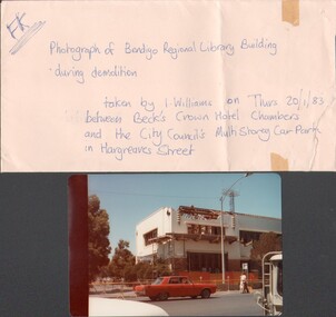
Photograph - Demolition of Bendigo Regional Library Building
Colour photograph of demolition underway of the Bendigo Regional Library Building, Thurs.20/01/1983. Contains two photos and envelope description of perspective.bendigo regional library, demolition, 1983 -
 Bendigo Historical Society Inc.
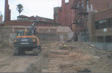
Photograph - Forest Street
Colour photograph showing the demolition work near the corner of Forest and High Street. Red bricks building around the excavation site. An excavator can be seen in the foreground and a man is crouching looking at something on the ground. On the back in pencil Forest street demolition ? 2011forest street, demolition -
 Bendigo Historical Society Inc.
Book - 'FORTUNA' AUCTION SALE, 1934
64 page booklet being the catalogue for sale of the collection of antique and modern furnishings at Fortuna Villa. Six days of sales from 18th to 23rd of June 1934. 2599 items listed. Auctioneers K.Gardner & Lang, Leonard Joel and J.H.Curnow & Son. Includes several sepia photos. Small flyer inside front cover advertising Demolition Auction Sale of Fortuna June 1938. Name of June Parry, 107 Wills St, Bendigo written on first page. Two handwritten pages of prices against some item numbers between pages 22 and 23. Printed by The Prahran Telegraph Printing Co.Auctioneers as shown above -
 Buninyong & District Historical Society
Photograph - Original B/W Photograph, Former Whyke's Grocer building, Warrenheip St, Buninyong, 18 September 1993
Original building was established by Whyke's family Grocery, built in 1860s. Stripped to apricot brickwork. Verandah removed. Situated East Side of Warrenheip St between Eyre St and Forest St, Buninyong. Building much altered and used as a restaurant in 1970s. Fell into disrepair. Revival took place but not restoration. 1990s under threat of demolition if not conforming to council safety requirements. Building has since been renovated as a pizza restaurant (2023). Vacant lots have since been built on.Established by a prominent local family, an example of a mid 19th century shop. Black and white photo of former Whykes Grocer, 1860's. Streetscape photo of former Whykes Grocer brick building. Power pole with Warrenheip St sign. 3 other shopfronts visible, street trees and vacant land between shops.buninyong, whykes, grocery, building, street scape, warrenheip st -
Kew Historical Society Inc
Archive (Sub-series) - Subject File, Kew Court House 1986-1989, 1986
Various partiesReference, Research, InformationSecondary Values (KHS Imposed Order)Subject file containing information relating to the Kew Post Office complex, including the Kew Court House and the Police Station. The correspondence between parties included the City of Kew, the Kew Historical Society, and the Victorian Government. Initially the correspondence related to the proposed use of the Court House as a Centre for the Society as it was being forced to vacate the Copy Shop (q.v) in Walpole Street due to its impending demolition. Later correspondence relates to the proposed sale of the Court House by the Victorian Government.kew - history, kew court house, kew police station, heritage campaigns - kew (vic)kew - history, kew court house, kew police station, heritage campaigns - kew (vic) -
Kew Historical Society Inc
Archive (Sub-series) - Subject File, Kew Historical Society, Houses [Kew], 1980
Various partiesReference, Research, InformationSecondary Values (KHS Imposed Order)Assorted printed materials, some published, such as: ‘What House is That? A guide to Victorian housing’ (Heritage Victoria, 2004), and guidelines for researching the history of a house (Fact Sheet, City of Boroondara). There is an article from the Progress Press about the demolition of Ellesmore, 80 Princess Street in 1977 (the article includes photographs of the demolition), Elizabeth Mackie’s notes on Myrtle Hill, and an article on the restoration of Mynda, Molesworth Street that was published in the Trust News (1987). Mrs Sewell of Stawell Street wrote handwritten notes/recollections about Cradley in Studley Park Road in 1981. In the photocopy about Ellesmore, there is also a separate article on the proposed replacement of the Walmer Street Bridge. There is also correspondence and an article on Stanhope on the corner of Burke and Cotham Roads. The file includes general real estate information and data.kew historical society - archives, kew - history, myrtle hill (kew), ellesmore - 80 princess street - kew (vic), mynda - molesworth street - kew (vic), stanhope - burke road - cotham road - kew (vic), cradley - studley park road - kew (vic), 17 queen street - kew (vic.)kew historical society - archives, kew - history, myrtle hill (kew), ellesmore - 80 princess street - kew (vic), mynda - molesworth street - kew (vic), stanhope - burke road - cotham road - kew (vic), cradley - studley park road - kew (vic), 17 queen street - kew (vic.) -
 Kew Historical Society Inc
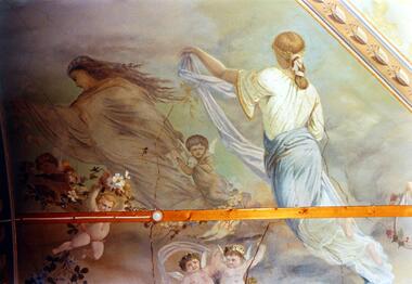
Photograph - Ceiling fresco, Ballroom, ‘Southesk’, Cotham Road, Stewart West, 1970
... to the demolition of the house, and are the best examples of the murals ...Colour enlargement of a photograph (slide) of Southesk (formerly Ordsall) in Cotham Road, Kew (demolished 1970).The ceilings of and architraves of Ordsall were painted by artists employed by the decorating company, Cullis Hill & Co. The frescos, of which fragments survive, were some of the most important murals used as elements of interior decoration in Melbourne during the Boom Period of the 1880s. These photographs were taken immediately prior to the demolition of the house, and are the best examples of the murals.Notwithstanding its grand Italianate façade, the most important aspect of Southesk (formerly ‘Ordsall’) were the murals in the front two rooms. An article in the Melbourne Argus in 1882 records that Mr Vandenbrandt and Signor Rizzi created these under the supervision of Cullis Hill. This fresco from the ceiling of the ballroom depicts ‘Night, represented by a female figure in a diaphanous garment, skirted with flowers, wafted before the approaching dawn into space illuminated by the moonlight, and peopled by the fairies, is a striking picture. Flying with her are an attendant Cupid bearing an artificial light, and a tired little votary of Bacchus with a reversed wine-pitcher and goblet’.david carnegie, john halfey, southesk - cotham road - kew (vic), ordsall - cotham road - kew (vic) -
 Kew Historical Society Inc
Photograph - Ceiling fresco, Ballroom, ‘Southesk’, Cotham Road, Stewart West, 1970
... to the demolition of the house, and are the best examples of the murals ...Colour enlargement of a photograph (slide) of Southesk (formerly Ordsall) in Cotham Road, Kew (demolished 1970).The ceilings of and architraves of Ordsall were painted by artists employed by the decorating company, Cullis Hill & Co. The frescos, of which fragments survive, were some of the most important murals used as elements of interior decoration in Melbourne during the Boom Period of the 1880s. These photographs were taken immediately prior to the demolition of the house, and are the best examples of the murals.The most significant decorative aspects of Southesk (formerly ‘Ordsall’) were the murals in the front two rooms. An article in the Melbourne Argus in 1882 records that Mr Vandenbrandt and Signor Rizzi created these under the supervision of Cullis Hill. This fresco from the ceiling of the ballroom is believed to depict two of the Seasons. Signor Rizzi was a renowned painter of flowers. He is credited with painting these parts of the murals. Examples of his floral paintings can still be seen at Villa Alba in Walmer Street.david carnegie, john halfey, southesk - cotham road - kew (vic), ordsall - cotham road - kew (vic) -
 Kew Historical Society Inc
Photograph - Ceiling fresco, Ballroom, ‘Southesk’, Cotham Road, Stewart West, 1970
... to the demolition of the house, and are the best examples of the murals ...Colour enlargement of a photograph (slide) of Southesk (formerly Ordsall) in Cotham Road, Kew (demolished 1970).The ceilings of and architraves of Ordsall were painted by artists employed by the decorating company, Cullis Hill & Co. The frescos, of which fragments survive, were some of the most important murals used as elements of interior decoration in Melbourne during the Boom Period of the 1880s. These photographs were taken immediately prior to the demolition of the house, and are the best examples of the murals.The most significant decorative aspects of Southesk (formerly ‘Ordsall’) were the murals in the front two rooms. An article in the Melbourne Argus in 1882 records that Mr Vandenbrandt and Signor Rizzi created these under the supervision of Cullis Hill. This fresco from the ceiling of the ballroom is believed to depict ‘Africa’. The article records that: ‘Notwithstanding the large size of the drawings they are often marked by delicate touches, and a minuteness of detail in evident sympathy with nature. The figures have grace, life and animation and the skillful shading of the colours used — chiefly amber, gold, light blue, green, light fawn and brown – is in harmony with the quiet tone of the general furnishing of the rooms.’david carnegie, john halfey, southesk - cotham road - kew (vic), ordsall - cotham road - kew (vic) -
 Kew Historical Society Inc
Photograph - Ceiling fresco, Ballroom, ‘Southesk’, Cotham Road, Stewart West, 1970
... to the demolition of the house, and are the best examples of the murals ...Colour enlargement of a photograph (slide) of Southesk (formerly Ordsall) in Cotham Road, Kew (demolished 1970).The ceilings of and architraves of Ordsall were painted by artists employed by the decorating company, Cullis Hill & Co. The frescos, of which fragments survive, were some of the most important murals used as elements of interior decoration in Melbourne during the Boom Period of the 1880s. These photographs were taken immediately prior to the demolition of the house, and are the best examples of the murals.The most significant decorative aspects of Southesk (formerly ‘Ordsall’) were the murals in the front two rooms. An article in the Melbourne Argus in 1882 records that Mr Vandenbrandt and Signor Rizzi created these under the supervision of Cullis Hill. This fresco from the ceiling of the ballroom is believed to depict one of the ‘boldly drawn four great geographical divisions of the Earth’. The crowned woman, believed to represent Europe, stands aloft in a chariot drawn by cherubs holding garlands of flowers.david carnegie, john halfey, southesk - cotham road - kew (vic), ordsall - cotham road - kew (vic) -
 Kew Historical Society Inc
Photograph - Ceiling fresco, Drawingroom, ‘Southesk’, Cotham Road, Stewart West, 1970
... to the demolition of the house, and are the best examples of the murals ...Colour enlargement of a photograph (slide) of Southesk (formerly Ordsall) in Cotham Road, Kew (demolished 1970).The ceilings of and architraves of Ordsall were painted by artists employed by the decorating company, Cullis Hill & Co. The frescos, of which fragments survive, were some of the most important murals used as elements of interior decoration in Melbourne during the Boom Period of the 1880s. These photographs were taken immediately prior to the demolition of the house, and are the best examples of the murals.The most significant decorative aspects of Southesk (formerly ‘Ordsall’) were the murals in the front two rooms. An article in the Melbourne Argus in 1882 records that Mr Vandenbrandt and Signor Rizzi created these under the supervision of Cullis Hill. This fresco from the ceiling of the drawingroom was described by the reporter as ‘done in the quaint old 14th century style’. This section depicts ‘out-door sports. The fishing-lines of the jester and the almoner have become entangled, and a large wolf-dog seems disposed to arbitrate in the difficulty, while a party of young men and maidens are angling, feeding swans, or training hawks for a future day’s sport.’david carnegie, john halfey, southesk - cotham road - kew (vic), ordsall - cotham road - kew (vic) -
 Kew Historical Society Inc
Photograph - Ceiling fresco, Drawingroom, ‘Southesk’, Cotham Road, Stewart West, 1970
... to the demolition of the house, and are the best examples of the murals ...Colour enlargement of a photograph (slide) of Southesk (formerly Ordsall) in Cotham Road, Kew (demolished 1970).The ceilings of and architraves of Ordsall were painted by artists employed by the decorating company, Cullis Hill & Co. The frescos, of which fragments survive, were some of the most important murals used as elements of interior decoration in Melbourne during the Boom Period of the 1880s. These photographs were taken immediately prior to the demolition of the house, and are the best examples of the murals.The most significant decorative aspects of Southesk (formerly ‘Ordsall’) were the murals in the front two rooms. An article in the Melbourne Argus in 1882 records that Mr Vandenbrandt and Signor Rizzi created these under the supervision of Cullis Hill. This fresco from the ceiling of the drawingroom was described by the reporter as ‘done in the quaint old 14th century style … The second panel represents a hawking party. The ladies hold aloft the natural perches for their falcons. The men, seated in picturesque variety of attitude, hold their cross-bows, and a boy is relieving a heron from an arrow which has pierced its bosom.’david carnegie, john halfey, southesk - cotham road - kew (vic), ordsall - cotham road - kew (vic) -
 Kew Historical Society Inc
Album - Scrapbook, Eva Grant, Historic Buildings, Kew, 1958-78, 1970s
One of three scrapbooks of photographs and newspaper cuttings taken and or collected by Eva Grant, a past member of the Kew Historical Society, which were donated by her niece, Julie Thomson. The albums include many photographs of Kew from the 1950s to the 1970s. Buildings included in the scrapbook include: Billy Hughes' house - 167 Cotham Road Congregational Church - Walpole Street (c.1978) Country Roads Board - Denmark Street (1960) Dorothy Rogers Reserve - Studley Park Road Ellsmere (also Ellesmere/Ellsmore) - Princess Street Field Place - 3 Henty Court Fernhurst - 13 Fernhurst Grove Kew Civic Centre (1959) Kew Junction (1958) Kew Railway Station (1902, 1959) Kew Recreation Hall - Wellington Street (1960) Neama (Hall) - Studley Park Road Southesk (formerly Ordsall) - Cotham Road (c.1960) St Anthony's Home for Babies (formerly Madford) - 43 Wellington Street (c.1976) Studley House - Nolan AvenueThe scrapbook contains historically significant, rare and sometimes unique images of significant heritage buildings in Kew, including their erection and demolition. 11-page scrapbook of photographs and newspaper clippings with annotations by Eva Grant, a past member of the Kew Historical Society. The pages of the album can be viewed in the image carousel above. Based on the text and known dates of demolition of a number of the buildings, the scrapbook was assembled over a twenty year period between c.1958-c.1978.Includes letter from donoreva grant, billy hughes' house - 167 cotham road, congregational church - walpole street - kew, country roads board - denmark street - kew, dorothy rogers reserve - studley park road - kew, field place - 3 henty court - kew (vic), ellsmere (also ellesmere/ellsmore) - princess street - kew, fernhurst - 13 fernhurst grove - kew (vic), kew civic centre - civic drive - kew (vic), kew junction - kew (vic), kew railway station - denmark street - kew (vic), recreation hall - wellington street - kew, neama - hall - studley park road - kew (vic), southesk - ordsall - cotham road- kew (vic), st anthony's home for babies - madford - 43 wellington street (vic), studley house - nolan avenue - kew (vic) -
 Kew Historical Society Inc
Photograph, Deepdene
Rare photograph of a significant Melbourne home.Photograph of the historically significant house, Deepdene, which was located before demolition on the southeast corner of Burke Road and Cotham Road. The photograph is on the back of a subdivision plan of the Auburn Heights Estate.deepdene -
 Kew Historical Society Inc
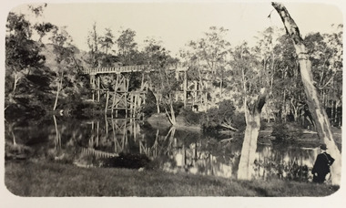
Photograph - Demolishing the Zig-Zag Bridge, 1929
Henry Beater Christian (1886-1962) , was a descendant of one of the earliest settler families in Kew. Employed at the Kew Asylum as a 'public servant', he was a skilled amateur photographer, photographing numerous scenes in Kew and on his travels around Victoria. The majority of his photographs date from 1916 to 1929. His finest photographs are housed in two photograph albums. Rare photograph of the demolition of the Zig-Zag Bridge linking the two asylums on either side of the Yarra River.Digital copy of a photograph from page 16 of the 47-page photograph album containing 261 gelatinous silver images, loaned by Diane Washfold with permission given to digitise and hold a copy in our collection. The Zig-Zag Bridge linked the grounds of the Yarra Bend and Kew Asylums. The wooden bridge was constructed in the 1870s and lasted through numerous floods until its destruction in 1929. A horizontal structure, the walkway was reached via a wooden staircase on the Kew bank of the river. The steps were required due to the different levels of the banks on this stretch of the river. The photo is of the bridge after its partial destruction in a flood. An empty boat floats on the river. There is a car on the far bank and a man sits on one of the cross supports preparing to set the structure alight."Demolishing Zig-Zag / 6. 1929"henry beater christian (1886-1962), landscape photography, kew (vic.) — yarra river, christian-washfold collection, photograph albums, zig-zag bridge -
 Kew Historical Society Inc
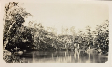
Photograph - Demolishing the Zig-Zag Bridge, 1929
Henry Beater Christian (1886-1962) , was a descendant of one of the earliest settler families in Kew. Employed at the Kew Asylum as a 'public servant', he was a skilled amateur photographer, photographing numerous scenes in Kew and on his travels around Victoria. The majority of his photographs date from 1916 to 1929. His finest photographs are housed in two photograph albums. Rare photograph of the demolition of the Zig-Zag Bridge linking the two asylums on either side of the Yarra River.Digital copy of a photograph from page 16 of the 47-page photograph album containing 261 gelatinous silver images, loaned by Diane Washfold with permission given to digitise and hold a copy in our collection. The Zig-Zag Bridge linked the grounds of the Yarra Bend and Kew Asylums. The wooden bridge was constructed in the 1870s and lasted through numerous floods until its destruction in 1929. A horizontal structure, the walkway was reached via a wooden staircase on the Kew bank of the river. The steps were required due to the different levels of the banks on this stretch of the river. This is a photo of the bridge before part of it was destroyed in a flood in 1929. A man, perhaps Henry Christian, stands at the right of the foreground."Demolishing Zig-Zag / 6. 1929"henry beater christian (1886-1962), landscape photography, kew (vic.) — yarra river, christian-washfold collection, photograph albums, zig-zag bridge -
 Kew Historical Society Inc
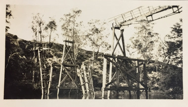
Photograph - Demolishing the Zig-Zag Bridge, 1929
Henry Beater Christian (1886-1962) , was a descendant of one of the earliest settler families in Kew. Employed at the Kew Asylum as a 'public servant', he was a skilled amateur photographer, photographing numerous scenes in Kew and on his travels around Victoria. The majority of his photographs date from 1916 to 1929. His finest photographs are housed in two photograph albums. Rare photograph of the demolition of the Zig-Zag Bridge linking the two asylums on either side of the Yarra River.Digital copy of a photograph from page 16 of the 47-page photograph album containing 261 gelatinous silver images, loaned by Diane Washfold with permission given to digitise and hold a copy in our collection. The Zig-Zag Bridge linked the grounds of the Yarra Bend and Kew Asylums. The wooden bridge was constructed in the 1870s and lasted through numerous floods until its destruction in 1929. A horizontal structure, the walkway was reached via a wooden staircase on the Kew bank of the river. The steps were required due to the different levels of the banks on this stretch of the river. This is a photo of the bridge showing the level of destruction caused by the initial damage from the flood and subsequent dismantling of the horizontal struts and walkway, prior to to its destruction by fire."Demolishing Zig-Zag / 6. 1929"henry beater christian (1886-1962), landscape photography, kew (vic.) — yarra river, christian-washfold collection, photograph albums, zig-zag bridge -
 Kew Historical Society Inc
Photograph - Demolishing the Zig-Zag Bridge, 1929
Henry Beater Christian (1886-1962) , was a descendant of one of the earliest settler families in Kew. Employed at the Kew Asylum as a 'public servant', he was a skilled amateur photographer, photographing numerous scenes in Kew and on his travels around Victoria. The majority of his photographs date from 1916 to 1929. His finest photographs are housed in two photograph albums. Rare photograph of the demolition of the Zig-Zag Bridge linking the two asylums on either side of the Yarra River.Digital copy of a photograph from page 16 of the 47-page photograph album containing 261 gelatinous silver images, loaned by Diane Washfold with permission given to digitise and hold a copy in our collection. The Zig-Zag Bridge linked the grounds of the Yarra Bend and Kew Asylums. The wooden bridge was constructed in the 1870s and lasted through numerous floods until its destruction in 1929. A horizontal structure, the walkway was reached via a wooden staircase on the Kew bank of the river. The steps were required due to the different levels of the banks on this stretch of the river. This is a closeup view of the bridge showing the level of destruction caused by the initial damage from the flood and subsequent dismantling of the horizontal struts and walkway, prior to to its destruction by fire."Demolishing Zig-Zag / 6. 1929"henry beater christian (1886-1962), landscape photography, kew (vic.) — yarra river, christian-washfold collection, photograph albums, zig-zag bridge -
 Kew Historical Society Inc
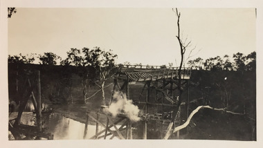
Photograph - Demolishing the Zig-Zag Bridge, 1929
Henry Beater Christian (1886-1962) , was a descendant of one of the earliest settler families in Kew. Employed at the Kew Asylum as a 'public servant', he was a skilled amateur photographer, photographing numerous scenes in Kew and on his travels around Victoria. The majority of his photographs date from 1916 to 1929. His finest photographs are housed in two photograph albums. Rare photograph of the demolition of the Zig-Zag Bridge linking the two asylums on either side of the Yarra River.Digital copy of a photograph from page 16 of the 47-page photograph album containing 261 gelatinous silver images, loaned by Diane Washfold with permission given to digitise and hold a copy in our collection. The Zig-Zag Bridge linked the grounds of the Yarra Bend and Kew Asylums. The wooden bridge was constructed in the 1870s and lasted through numerous floods until its destruction in 1929. A horizontal structure, the walkway was reached via a wooden staircase on the Kew bank of the river. The steps were required due to the different levels of the banks on this stretch of the river. This is a view of the bridge showing the level of destruction caused by the initial damage from the flood, the subsequent dismantling of the horizontal struts and walkway, and the setting on fire of the remaining structure."Demolishing Zig-Zag / 6. 1929"henry beater christian (1886-1962), landscape photography, kew (vic.) — yarra river, christian-washfold collection, photograph albums, zig-zag bridge -
 Kew Historical Society Inc
Photograph - Demolishing the Zig-Zag Bridge, 1929
Henry Beater Christian (1886-1962) , was a descendant of one of the earliest settler families in Kew. Employed at the Kew Asylum as a 'public servant', he was a skilled amateur photographer, photographing numerous scenes in Kew and on his travels around Victoria. The majority of his photographs date from 1916 to 1929. His finest photographs are housed in two photograph albums. Rare photograph of the demolition of the Zig-Zag Bridge linking the two asylums on either side of the Yarra River.Digital copy of a photograph from page 16 of the 47-page photograph album containing 261 gelatinous silver images, loaned by Diane Washfold with permission given to digitise and hold a copy in our collection. The Zig-Zag Bridge linked the grounds of the Yarra Bend and Kew Asylums. The wooden bridge was constructed in the 1870s and lasted through numerous floods until its destruction in 1929. A horizontal structure, the walkway was reached via a wooden staircase on the Kew bank of the river. The steps were required due to the different levels of the banks on this stretch of the river. This night-time photograph shows the remaining parts of the bridge being destroyed by fire."Demolishing Zig-Zag / 6. 1929"henry beater christian (1886-1962), landscape photography, kew (vic.) — yarra river, christian-washfold collection, photograph albums, zig-zag bridge -
 Kew Historical Society Inc
Functional object - Wrought iron nails from 'Reno', St John's Parade, c. 1864
Comparatively few weatherboard houses in Kew survived from the early years of settlement into the second half of the 20th century. One such property was ‘Reno’, which once stood on the east side of St John’s Parade. Its earliest recorded owner was the architect Samuel Cocking who lived there from c.1865 until his death in 1888. The original landholding was bordered by Cotham Road, Glenferrie Road, Wellington Street, and Charles Street. The southern portion of this land included a fine orchard, with many imported trees. The old summer house, at first in the orchard, was later removed to the house garden. The MMBW Detail Plan No.1576 (1904) shows the remaining portion of the original land holding, including a semi-circular pathway at the front, and garden features such as an aviary, a fountain and grotto, and a fernery. None of these are apparent in photographs dating from the 1960s, where the garden, which once included rare plants provided by Baron Von Mueller, surrounds the cottage in a tangled frenzy. Despite a ‘local significance’ classification by the National Trust, the house was demolished in 1977.7 square headed iron nails collected from Reno before its demolition. In envelope marked with the name Joy Stewartreno, nails, samuel cocking -
 Kew Historical Society Inc
Plan, Melbourne and Metropolitan Board of Works, Melbourne & Metropolitan Board of Works : Borough of Kew : Detail Plan No.1294 & 1295, 1904
... Avenue in 1927, the demolition of the house in 1960 enabled... Avenue in 1927, the demolition of the house in 1960 enabled ...The Melbourne and Metropolitan Board of Works (MMBW) plans were produced from the 1890s to the 1950s. They were crucial to the design and development of Melbourne's sewerage and drainage system. The plans, at a scale of 40 feet to 1 inch (1:480), provide a detailed historical record of Melbourne streetscapes and environmental features. Each plan covers one or two street blocks (roughly six streets), showing details of buildings, including garden layouts and ownership boundaries, and features such as laneways, drains, bridges, parks, municipal boundaries and other prominent landmarks as they existed at the time each plan was produced. (Source: State Library of Victoria). This plan forms part of a large group of MMBW plans and maps that was donated to the Society by the Mr Poulter, City Engineer of the City of Kew in 1989. Within this collection, thirty-five hand-coloured plans, backed with linen, are of statewide significance as they include annotations that provide details of construction materials used in buildings in the first decade of the 20th century as well as additional information about land ownership and usage. The copies in the Public Record Office Victoria and the State Library of Victoria are monochrome versions which do not denote building materials so that the maps in this collection are invaluable and unique tools for researchers and heritage consultants. A number of the plans are not held in the collection of the State Library of Victoria so they have the additional attribute of rarity.Original survey plan, issued by the MMBW to a contractor with responsibility for constructing sewers in the area identified on the plan within the Borough of Kew. The plan was at some stage hand-coloured, possibly by the contractor, but more likely by officers working in the Engineering Department of the Borough and later Town, then City of Kew. The hand-coloured sections of buildings on the plan were used to denote masonry or brick constructions (pink), weatherboard constructions (yellow), and public buildings (grey).The streets and built structures in MMBW Detail Plan 1294 & 1295 were surveyed in 1903 and released to contractors in 1904. This plan is one of two in the collection where the lithographers amalgamated two separate plans. Both plans include sections of Studley Park. Dominating the south and west corners of Kew Junction are the Clifton and Kew Hotels. The Kew Hotel, owned by Patrick O’Shaughnessy was one of the oldest in Kew. MMBW plans were amended over time to take account of new subdivisions such as that which created Merrion Place. Of the four mansions shown in Studley Park Road, three remain – ‘Field Place’, the home of Frances Henty, ‘Leaghur’ and ‘Darley’. ‘Byram’ (later ‘Goathland’, then ‘Tara Hall’) was an architectural marvel. Designed in 1888 by E.G. Kilburn for the paper magnate George Ramsden, it was demolished in 1960. While an earlier sale of the southern section of Byram had created Tara Avenue in 1927, the demolition of the house in 1960 enabled the extension of Tara Avenue northward.melbourne and metropolitan board of works, detail plans, mmbw 1294, mmbw 1295, cartography -
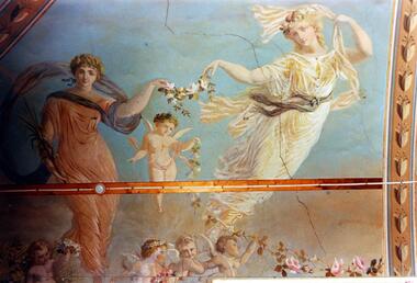
![Section of mural from the ballroom of 'Ordsall' [Southesk], Cotham Road](/media/collectors/550653872162f11fb04854aa/items/57295b902162f108e8d6367a/item-media/614c29d34739c077d925ddc5/item-fit-380x285.jpg) Kew Historical Society Inc
Kew Historical Society IncPainting - Section of mural from the ballroom of 'Ordsall' [Southesk], Cotham Road, Cullis Hill & Co, 1882
... to the house's demolition in 1970, this small fragment of the fresco ...Ordsall, renamed Southesk in the 20th century was built for John Halfey in or before 1865. The house was rebuilt in the 1870s to designs by architect Michael Hennessy. In 1882 the house was redecorated by the firm of Culls Hill & Co., who hired the artists 'Mr Vandenbrandt' and 'Signor Rizzi" to paint the ceilings of the ballroom and the drawingroom. The artistic triumph was described in detail in The Argus, 30 October, 1882. In 1947, Southesk was purchased by the Kew City Council. For 23 years it was used as a meeting place for community groups. The house was then demolished in 1970 to make way for a new Town Hall.The interiors of the two main reception rooms at Ordsall included some of the most outstanding domestic frescos painted in Australia in the late Victorian period. These frescos were executed by artists hired by the firm of Cullis Hill & Co. While a number of photographs were taken of the interiors prior to the house's demolition in 1970, this small fragment of the fresco is one of only three extant. The fresco allows conservators to examine and evaluate fresco techniques of the period.One of only two fragments of the painted domed ceiling of the ballroom of Ordsall (later renamed Southesk) which once stood at the corner of Cotham Road and Charles Street, Kew. This triangular piece of the fresco is of a cherub's face.Label: 'This is from the "Southesk" ballroom 14-7-70'ordsall, southesk, cullis hill & co. -
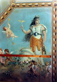
![Section of mural from the ballroom of 'Ordsall' [Southesk], Cotham Road](/media/collectors/550653872162f11fb04854aa/items/5729628d2162f108e8d6d03f/item-media/614c29204739c077d925d5a8/item-fit-380x285.jpg) Kew Historical Society Inc
Kew Historical Society IncPainting - Section of mural from the ballroom of 'Ordsall' [Southesk], Cotham Road, Cullis Hill & Co, 1882
... to the house's demolition in 1970, this small fragment of the fresco ...Ordsall, renamed Southesk in the 20th century was built for John Halfey in or before 1865. The house was rebuilt in the 1870s to designs by architect Michael Hennessy. In 1882 the house was redecorated by the firm of Culls Hill & Co., who hired the artists 'Mr Vandenbrandt' and 'Signor Rizzi" to paint the ceilings of the ballroom and the drawingroom. The artistic triumph was described in detail in The Argus, 30 October, 1882. In 1947, Southesk was purchased by the Kew City Council. For 23 years it was used as a meeting place for community groups. The house was then demolished in 1970 to make way for a new Town Hall.The interiors of the two main reception rooms at Ordsall included some of the most outstanding domestic frescos painted in Australia in the late Victorian period. These frescos were executed by artists hired by the firm of Cullis Hill & Co. While a number of photographs were taken of the interiors prior to the house's demolition in 1970, this small fragment of the fresco is one of only three extant. The fresco allows conservators to examine and evaluate fresco techniques of the period.One of only two fragments of the painted domed ceiling of the ballroom of Ordsall (later renamed Southesk) which once stood at the corner of Cotham Road and Charles Street, Kew. This roughly square piece of the plasterwork shows a woman's head. Given the size of the face, it is believed that this section of the fresco represents one of the four 'geographic depictions of the earth including the seasons, night and morning'.Label: 'This is from the Southesk Ballroom 14-7-70'cullis hill & co., fresco, ordsall, southesk -
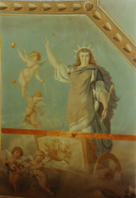
![Section of mural from the Drawingroom of 'Ordsall' [Southesk], Cotham Road](/media/collectors/550653872162f11fb04854aa/items/572965572162f108e8d71dfd/item-media/614c29844739c077d925d8ef/item-fit-380x285.jpg) Kew Historical Society Inc
Kew Historical Society IncPainting - Section of mural from the Drawingroom of 'Ordsall' [Southesk], Cotham Road, Cullis Hill & Co, 1882
... taken of the interiors prior to the house's demolition in 1970 ...Ordsall, renamed Southesk in the 20th century was built for John Halfey in or before 1865. The house was rebuilt in the 1870s to designs by architect Michael Hennessy. In 1882 the house was redecorated by the firm of Cullis Hill & Co., who hired the artists 'Mr Vandenbrandt' and 'Signor Rizzi" to paint the ceilings of the ballroom and the drawingroom. The artistic triumph was described in detail in The Argus, 30 October, 1882. In 1947, Southesk was purchased by the Kew City Council. For 23 years it was used as a meeting place for community groups. The house was then demolished in 1970 to make way for a new Town Hall.The interiors of the two main reception rooms at Ordsall included some of the most outstanding domestic frescos painted in Australia in the late Victorian period. These frescos were executed by artists hired by the firm of Cullis Hill & Co. While a number of photographs were taken of the interiors prior to the house's demolition in 1970, this small fragment of the fresco is one of only three extant. The fresco allows conservators to examine and evaluate fresco techniques of the period.A fragment of the painted domed ceiling of the drawingroom of Ordsall (later renamed Southesk) which once stood at the corner of Cotham Road and Charles Street, Kew. This rectangular fragment of painted plaster is a small section of the rectangular frieze of neo-gothic scenes that were a feature of the drawingroom ceiling. The fragment differs from those remaining from the ballroom in that it includes a section of gold leaf.Label: 'This is from "Southesk" drawing room'ordsall, southesk, cullis hill & co., halfey, john -
 Surrey Hills Historical Society Collection
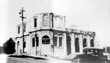
Photograph, Demolition of Tower House Day and Boarding School, Surrey Hills in 1932 (1)
... Demolition of Tower House Day and Boarding School, Surrey... corner "498" in red biro; centre "Demolition of / Tower House Day... corner "498" in red biro; centre "Demolition of / Tower House Day ...This building dated back to the 1880s and had previously operated as Delany's Hotel and then the Royal Hotel. It was built near the site of the original Delany's Hotel, built in 1856. The Royal Hotel closed in 1921 after the area voted to be a 'dry area' in the local option poll. Tower House Day and Boarding School operated from 1921 until 1932. Norman Carter took many photos of Surrey Hills and Mont Albert from the 1920s; many were associated with events and activities of the Church of England.Black and white photo of a partially demolished building. The roof and part of the second storey are missing. What remains indicates that it has been a large building in the Victorian style. Along one side at ground level there are 4 arches, perhaps entry to a covered veranda, above which is a colonnade, and perhaps an open veranda on the upper level. There is a mixture of treatments to the surrounds of the windows. On the corner, within an arch which may have once been a doorway, is a sign reading: "TOWER HOUSE / DAY / & / BOARDING SCHOOL". There is a car with a retractable hood in the lower RH Corner of the photo.Rear top centre in blue biro "1932" (crossed out); top RH corner "498" in red biro; centre "Demolition of / Tower House Day & Boarding / cr Canterbury & Broughton Rds / previously Tower House Hotel / originally Royal Hotel / See partner photo."; bottom RH cnr "demol (in red biro) / 20-8-32". All in Jocelyn Hall's handwriting.tower house day and boarding school, schools, education, royal hotel, hotels, construction and demolition, dry area, licensing polls, temperance movement, delany's hotel, norman carter