Showing 1676 items
matching main creek
-
 Eltham District Historical Society Inc
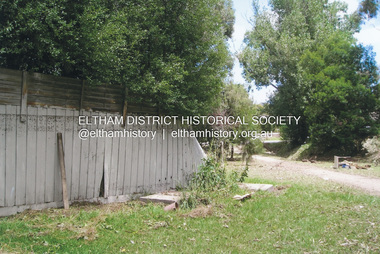
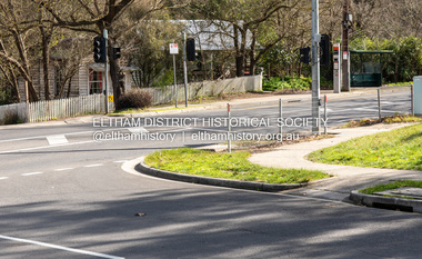
Photograph, Fay Bridge, Flood damage at Nillumbik Medical Centre, 1078 Main Road, Eltham, 26 December 2011
Flood damage resulting from a late afternoon storm on Christmas Day 2011. A flash flood occurred from significant rain fall and hail, which accumulated along an old waterway with floodwater submerging cars along Valonia Drive then down Grove Street flooding houses, through the Bible Street Reserve where it then submerged Main Road washing away the small railway trestle bridge opposite the reserve then flooding the Judge Book Village before finally entering the Diamond Creek..fay bridge collection, 2011-12-26, bible street reserve, flood damage, floods, floodwater, main road, nillumbik medical centre -
 Eltham District Historical Society Inc
Newsclipping, Vince Chadwick, Violent storms shatter the peace of Christmas, The Age, Monday, December 26, p3, 2011
A late afternoon storm on Christmas Day 2011. A flash flood occurred from significant rain fall and hail, which accumulated along an old waterway with floodwater submerging cars along Valonia Drive then down Grove Street flooding houses, through the Bible Street Reserve where it then submerged Main Road washing away the small railway trestle bridge opposite the reserve then flooding the Judge Book Village before finally entering the Diamond Creek. Widespread damage occured from hail and flash flooding.fay bridge collection, 2011-12-26, eltham, flood damage, floods, grove street, main road, valonia drive -
 Eltham District Historical Society Inc
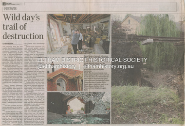
Newsclipping, Reid Sexton, Wild day's trail of destruction, The Age, Tuesday, December 27, pp4-5, 2011
A late afternoon storm on Christmas Day 2011. A flash flood occurred from significant rain fall and hail, which accumulated along an old waterway with floodwater submerging cars along Valonia Drive then down Grove Street flooding houses, through the Bible Street Reserve where it then submerged Main Road washing away the small railway trestle bridge opposite the reserve then flooding the Judge Book Village before finally entering the Diamond Creek. Widespread damage occured from hail and flash flooding.fay bridge collection, eltham, 2011-12-27, flood damage, floods, floodwater -
 Eltham District Historical Society Inc
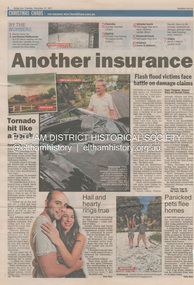
Newsclipping, Angus Thompson et al, Another insurance storm brews, Herald Sun, Tuesday, December 27, pp4-5, 2011
A late afternoon storm on Christmas Day 2011. A flash flood occurred from significant rain fall and hail, which accumulated along an old waterway with floodwater submerging cars along Valonia Drive then down Grove Street flooding houses, through the Bible Street Reserve where it then submerged Main Road washing away the small railway trestle bridge opposite the reserve then flooding the Judge Book Village before finally entering the Diamond Creek. Widespread damage occured from hail and flash flooding.fay bridge collection, eltham, 2011-12-27, flood damage, floods, floodwater -
 Eltham District Historical Society Inc
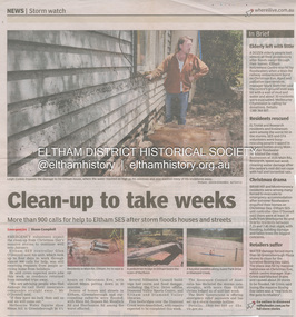
Newsclipping, Shaun Campbell, Clean-up to take weeks, Diamond Valley Leader, December 2011
A late afternoon storm on Christmas Day 2011. A flash flood occurred from significant rain fall and hail, which accumulated along an old waterway with floodwater submerging cars along Valonia Drive then down Grove Street flooding houses, through the Bible Street Reserve where it then submerged Main Road washing away the small railway trestle bridge opposite the reserve then flooding the Judge Book Village before finally entering the Diamond Creek. Widespread damage occured from hail and flash flooding.fay bridge collection, eltham, flood damage, floods, floodwater -
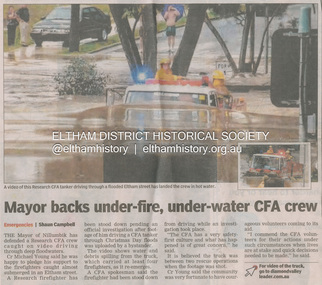 Eltham District Historical Society Inc
Newsclipping, Shaun Campbell, Mayor backs under-fire, under-water CFA crew, Diamond Valley Leader, December 2011
A late afternoon storm on Christmas Day 2011. A flash flood occurred from significant rain fall and hail, which accumulated along an old waterway with floodwater submerging cars along Valonia Drive then down Grove Street flooding houses, through the Bible Street Reserve where it then submerged Main Road washing away the small railway trestle bridge opposite the reserve then flooding the Judge Book Village before finally entering the Diamond Creek. Widespread damage occured from hail and flash flooding.fay bridge collection, eltham, flood damage, floods, floodwater, main road, research fire brigade -
 Eltham District Historical Society Inc
Photograph, Fay Bridge, Alistair Knox Park, Eltham, 13 October 2016
fay bridge collection, 2016-10-13, alistair knox park, diamond creek (creek), eltham -
 Eltham District Historical Society Inc
Photograph, Fay Bridge, Ruins beside the Diamond Creek at Wattle Glen, 13 October 2016
The newly constructed Diamond Creek Trail from Diamond Creek to Wattle Glen completed in February 2021 winds around these ruins just pass the high transmission power lines near Herberts Lane and Collard Drive From Jean Verso, Nillumbik Historical Society, 15 April 2021 William Wandless Herbert bought the surrounding 100 acres in 1852. He was a native of Northumberland and the Scottish Borders who arrived in Melbourne in 1847. The house on the top of the mound would have been built not long after he bought the land; the farm was named "Greenhills". He married Elizabeth Wilson, daughter of John Wilson who had been in Diamond Creek since about 1846. Their first child was born in 1854 so there would be some form of dwelling from about that time. They had eight children who all survived to a good age. His will describes the house as part stone and part wood and of four rooms. Nillumbik Historical Society (NHS) believe it was one of the earliest if not the earliest house, in this part of the district. The remains of the stone house foundations are on top of the mound (photos on the VHD page) and the barn walls are on the north and to the east side of the mound. NHS is not sure how much or which part of the surrounding area was covered by the barns but they were large enough to hold dances after the race meetings that were held in the late 1880's on the adjacent creek flats. It would make sense with the lay of the land that they covered some of the ground to the north and east and used for farm storage, packing sheds for their apple and pear orchards and also for supporting the Nillumbik Gold Mine the family worked to the north up the gully. The path that comes down the gully and runs into the trail goes past the mine site which was on the west side of the gully a couple of hundred metres up from the flats. Heritage Victoria link for the site - https://vhd.heritagecouncil.vic.gov.au/places/12203fay bridge collection, 2016-10-13, diamond creek, diamond creek trail, ruins, wattle glen, william wandless herbert, greenhills, elizabeth wilson -
 Eltham District Historical Society Inc
Photograph, Fay Bridge, Centenary celebration, Monash Bridge, Hurstbridge, 7 November 2017
The area of Hurstbridge was originally known as Hurst’s-bridge after the timber bridge built over the Diamond Creek near Hurst’s station in late 1881/early 1882. It was replaced by a new concrete bridge designed by Sir John Monash over the Diamond Creek near Hurst's home of 'Mia Mia' at Hurstbridge. The official opening of the new Monash bridge at Hurstbridge was held 3 November 1917.fay bridge collection, 2017-11-07, hurstbridge, hurstbridge heritage trail, monash bridge, ruins -
 Eltham District Historical Society Inc
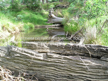
Photograph, Fay Bridge, Old timbers in the Diamond Creek at Hurstbridge, 27 February 2018
Just downstream from the bridgefay bridge collection, diamond creek (creek), hurstbridge, 2018-02-27 -
 Eltham District Historical Society Inc
Photograph, Fay Bridge, Remains of apple orchard near the Diamond Creek, Wattle Glen, 11 October 2018
The newly constructed Diamond Creek Trail from Diamond Creek to Wattle Glen completed in February 2021 winds past these apple trees that possibly lined the entrance to the Greenhills property From Jean Verso, Nillumbik Historical Society, 15 April 2021 William Wandless Herbert bought the surrounding 100 acres in 1852. He was a native of Northumberland and the Scottish Borders who arrived in Melbourne in 1847. The house on the top of the mound would have been built not long after he bought the land; the farm was named "Greenhills". He married Elizabeth Wilson, daughter of John Wilson who had been in Diamond Creek since about 1846. Their first child was born in 1854 so there would be some form of dwelling from about that time. They had eight children who all survived to a good age. His will describes the house as part stone and part wood and of four rooms. Nillumbik Historical Society (NHS) believe it was one of the earliest if not the earliest house, in this part of the district. The remains of the stone house foundations are on top of the mound (photos on the VHD page) and the barn walls are on the north and to the east side of the mound. NHS is not sure how much or which part of the surrounding area was covered by the barns but they were large enough to hold dances after the race meetings that were held in the late 1880's on the adjacent creek flats. It would make sense with the lay of the land that they covered some of the ground to the north and east and used for farm storage, packing sheds for their apple and pear orchards and also for supporting the Nillumbik Gold Mine the family worked to the north up the gully. The path that comes down the gully and runs into the trail goes past the mine site which was on the west side of the gully a couple of hundred metres up from the flats. Heritage Victoria link for the site - https://vhd.heritagecouncil.vic.gov.au/places/12203fay bridge collection, 2018-10-11, diamond creek, diamond creek trail, elizabeth wilson, greenhills, wattle glen, william wandless herbert, apple trees -
 Eltham District Historical Society Inc
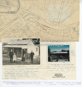
Document - Property Binder, 1203 Main Road, Eltham
Display panel: Map of Coleman's house location; 1904 photograph of Coleman house with Tom Newton, Mary Coleman (later Dowes) Mary Ann Coleman (nee Burke, mother of Jack Coleman, George Coleman, Mary Coleman), George Coleman, John (Jock) Coleman (father of John Coleman junior married to Margaret Coleman nee Dare); 1971 photograph of part of Coleman house. Typed document, compiled by Dorothy Peatling, Objection to Application 980731 Proposal for 6 units at 1203 Main Road Eltham, stories from Mrs Thomas, Ken Gaston, Frank Martin, Vicky Weston (nee Coleman), Frank Burgoyne, Heather Bakos, Mrs Dansey, and other historical information. Typed document, by Margaret Jennings, Objection to Application 980731 Proposal for 6 units at 1203 Main Road Eltham, history of site. Typed document, by Eltham District Historical Society, history of site, summary of interviews from Dorothy Peatling objection.main road, eltham, property, houses, coleman house, coleman crescent, mary coleman, mary dowes, mary ann coleman, mary ann burke, jack coleman, george coleman, john coleman, jock coleman, margaret coleman, margaret dare, dorothy peatling, mrs thomas, ken gaston, frank martin, vicky weston, vicky coleman, frank burgoyne, heather bakos, mrs dansey, wattletree road, edendale farm, orchard avenue eltham north, diamond creek, christmas creek, cobb and co royal mail -
 Eltham District Historical Society Inc
Postcard - Photograph postcard, The Rapids, Devils' Bank, Eltham, 1907
Devils' Bank was situated some two miles from Eltham. It is probably the section along the Yarra River where there are a series of rapids stretching past Petty's Orchard to Griffiths Park and the confluence with the Diamond Creek. Only three properties existed in this area in 1945 aerial maps, Worlingworth and the adjoining property on the bank of the Diamond Creek in Banoon Road and No. 2 Kent Hughes Road. Devils' Bank. The death of Ann Edwards, 77 years, an old resident of the district was reported who lived in an old hut at Devil's Bank who had been found dead in her bed on 13 May 1897 FOUND DEAD IN BED. (1897, May 28). Evelyn Observer, and South and East Bourke Record (Vic. : 1882 - 1902), p. 2 (MORNING.). Retrieved September 3, 2022, from http://nla.gov.au/nla.news-article60696388 A very similar view was published in the Leader paper in January 1908 - Devil's Bank Falls, Eltham VIEWS ON THE UPPER YARRA. (1908, January 11). Leader (Melbourne, Vic. : 1862 - 1918, 1935), p. 28. Retrieved September 3, 2022, from http://nla.gov.au/nla.news-article198106006 On the reverse of the postcard it appears to be postmarked Eltham, Dec 27, 1907 addressed to Mrs Christie Millmoss of Bull Street, Bendigo "Arrived here 10.45 am - ? ? raining cause of ? - ? till evenings it is lovely - but quite fresh after the (rain - crossed out) great ? - I may assume it all go well"Digital file only Postcards scanned from the collection of Michael Aitken on loan to EDHS, 2 Sep. 2022michael aitken collection, devils bank, eltham, postcards, rapids, yarra river -
 Eltham District Historical Society Inc
Postcard - Photograph postcard, Old Bridge, Kaylock's Crossing, Brougham Street, Eltham, c.1912
Date estimated to be circa 1912 based on the style of printing on the reverse of the card - Kodak Austral paper for real photo postcards, the paper was manufactured c.1908-1914 (See also POSTCARDS ON KODAK PAPER - IS IT POSSIBLE TO "DATE" THEM? http://tps.org.au/bb/viewtopic.php?t=115) Brougham Street was created in Josiah Holloway's 1851 subdivision of Little Eltham. It was one of several east-west streets shown on the subdivision plan as crossing the Diamond Creek. The western part was named Wellington Street on the subdivision plan but was later changed to conform with the name of the eastern part as acknowledgement of the continuity of the street. It is not known when the first bridge was constructed in Brougham Street however it was certainly mentioned at Council’s meeting of 2 June 1884 as being in a dangerous state of repair. This photo (c.1895) of an old bridge shows a very low-level simple log girder bridge crossing the creek at a right angle and so the approaches involved bends in the road alignment. This bridge was generally known as Kaylocks Bridge or Kaylock’s Crossing after the owner of the adjoining land. It was most likely built from around the mid-1850s, or a crossing of some fashion established as Richard George Kaylock, butcher of Little Eltham and his wife Emily Ann settled there in 1854. His property was in Wellington Street (now Brougham Street) and apparently extended across the Diamond Creek. The land on the western side of the creek was farmed, the house being on the eastern side. Kaylock's Bridge formed part of the original coach road to Eltham and in 1922 was described as an "old rustic bridge". Its low level and insubstantial construction made it susceptible to flood damage, necessitating frequent closures until repairs could be carried out. In September 1922, Council called for tenders for a new timber bridge to be constructed at Kaylock’s crossing. An engineering assessment carried out for the Council by Macleod Consulting at the time of the replacement suggested that the construction details indicate that it was in the 1900s, however this dating could possibly have been the result of numerous repairs undertaken over the years to flood damage. The tender was awarded to Mr Weller of Kangaroo Ground who commenced work in February 1923 on a higher-level timber trestle bridge. Work was slowed due to illness of the contractor and the accidental death of a man in March 1923 following the collapse of the bank after he had jumped into a hole that had just been blasted. The bridge was completed around July 1923 at which point the old structure was pulled up, marking what was described in the ‘Advertiser’ newspaper as the passing of an old and well-loved landmark in the district. In April 1924 the approach to Kaylocks bridge was washed away during the heavy flooding that destroyed the Main Road bridge. The western side was repaired, and an extra span was added to the eastern side using timber from the destroyed Main Road bridge. The bridge was again severely damaged four months later in August 1924 When a lack of finances delayed repairs to the Bridge Street bridge in 1931 (also referred to as Obelisk Bridge at the time), traffic had to detour via Brougham Street for some time. Local residents feared that the Bridge Street bridge might never reopen. Kaylocks Bridge was constantly subject to damage by floods. In the 1934 flood it was submerged by two feet of water. In more recent times the bridge was again severely damaged by flooding and repairs made. A new bridge and adjoining footbridge were constructed in 2009.Digital file only Postcards scanned from the collection of Michael Aitken on loan to EDHS, 2 Sep. 2022michael aitken collection, eltham, postcards, bridge, brougham street, diamond creek (creek), kaylocks bridge, wellington street -
 Eltham District Historical Society Inc
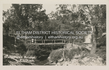
Postcard - Photograph postcard, O'Callaghan's Bridge, Eltham, c.1925
Based on the women's hat styles, estimated date is circa 1925. This is a replacement of an earlier lower level bridge which had an secondary high level footbridge added in 1917Digital file only Postcards scanned from the collection of Michael Aitken on loan to EDHS, 2 Sep. 2022michael aitken collection, eltham, postcards, diamond creek (creek), diamond street, diamond street bridge, o'callaghan's bridge -
 Eltham District Historical Society Inc
Photograph, Peter Pidgeon, Site of former Eltham Tennis Court, Wingrove Park, 2 Aug. 2022
View looking through Wingrove Park from near the Diamond Creek Trail towards the Coles Express Service Station and Mount Pleasant Road intersection. Comparison photo: SEPP_0720 Eltham Tennis Court, c.1909 and SEPP_0721 - Eltham Tennis Court, Lady Premiers 1909-1910 The tennis courts were located in Bremner’s Flats, present day Wingrove Park. The Eltham Lawn Tennis Club was formed on a Saturday evening, the 29th of October, 1898 at a meeting held at the Eltham State school. Twenty members were enrolled, and eight more shortly afterwards. Officers and a committee were duly elected, and the Treasurer was instructed to purchase the necessary requisites without delay. By the end of the first week in November all the requisites were to hand, two courts were marked out, and practice begun. The formal opening of the Courts of this Club took place on Saturday, November 12, 1898, when 26 members and their friends assembled. Part of a presentation by Peter Pidgeon to the Society, 13 August 2022 showcasing a series of photographs taken by John Henry Clark over the period 1895 to 1930. John Henry Clark was the youngest of three boys born to William Henry Clark (1823-1877) and Maria White (1843-1914). He and his brothers, William Charles Clark (1872-1945), Clement Kent Clark (1874-1912) operated a photography business (Clark Bros.) from 25 Thomas Street, Windsor near Prahran during the period c.1894 to 1914. Following death of Clement in September 1912 and their mother in 1914, the Clark Bros business appears to have dissolved, the premises demolished, and a new house was under construction in 1915. John set up business independently in 1914 operating out of 29 Moor Street, Fitzroy where he is registered in the 1914 and 1915 Electoral Rolls. By 1916 John had relocated to Eltham where he continued his practice as a photographer and took many of the early images around the district of Little Eltham. Around 1930 John changed professions and opened a small cobbler's shop in 1931 near the pond opposite Dalton Street adjacent to the Jarrold family cottage. He never married and continued his profession as a bootmaker from this little shop, maintaining a close relationship with Mrs Jarrold for the rest of their lives. His bootmaker shop remains today beside the Whitecloud cottage and is one of only three remaining shops in the area from the early 20th century.Comparative photo taken 2022 with one taken from same location over 100 years earlier by noted local photographer J.H. ClarkBorn Digitalbible street, eltham, j.h. clark photo (2022), bremner's flat, eltham lawn tennis club, eltham tennis court, main road, mount pleasant road, tennis court, wingrove park -
 Eltham District Historical Society Inc
Photograph, Peter Pidgeon, Site of former pond, Main Road, Eltham, 2 Aug. 2022
... Dalton Street diamond creek trail Jarrold Cottage Main Road White ...The view is taken from Main Road opposite Dalton Street looking northwest across Wingrove Park Trail and White Cloud cottage which belonged to the Jarrold family Comparison photo: 00779 - Pond near Eltham Park, c.1910 Shows the pond near Eltham Park (later Eltham Lower Park) circa 1910. The view is taken from Maria Street (Main Road) opposite Dalton Street looking northwest across the Dalton Street road extension reserve (now Wingrove Park Trail) and Jarrold farm. A haystack is visible. Also visible is a kerosene streetlight and Jarrold family cottage The pond was drained by Council in 1932 due to claims of mosquitoes though locals such as Thekla Jarrold and John Clark disputed this and protested to Council about the draining. It was in this news article that Thekla stated she had lived there 39 years and John Clark 22 years without cause for concern. Part of a presentation by Peter Pidgeon to the Society, 13 August 2022 showcasing a series of photographs taken by John Henry Clark over the period 1895 to 1930. John Henry Clark was the youngest of three boys born to William Henry Clark (1823-1877) and Maria White (1843-1914). He and his brothers, William Charles Clark (1872-1945), Clement Kent Clark (1874-1912) operated a photography business (Clark Bros.) from 25 Thomas Street, Windsor near Prahran during the period c.1894 to 1914. Following death of Clement in September 1912 and their mother in 1914, the Clark Bros business appears to have dissolved, the premises demolished, and a new house was under construction in 1915. John set up business independently in 1914 operating out of 29 Moor Street, Fitzroy where he is registered in the 1914 and 1915 Electoral Rolls. By 1916 John had relocated to Eltham where he continued his practice as a photographer and took many of the early images around the district of Little Eltham. Around 1930 John changed professions and opened a small cobbler's shop in 1931 near the pond opposite Dalton Street adjacent to the Jarrold family cottage. He never married and continued his profession as a bootmaker from this little shop, maintaining a close relationship with Mrs Jarrold for the rest of their lives. His bootmaker shop remains today beside the Whitecloud cottage and is one of only three remaining shops in the area from the early 20th century.Comparative photo taken 2022 with one taken from same location over 100 years earlier by noted local photographer J.H. ClarkBorn Digitaleltham, j.h. clark photo (2022), bootmaker's shop, dalton street, diamond creek trail, jarrold cottage, main road, white cloud cottage, wingrove park trail -
 Eltham District Historical Society Inc
Photograph, Peter Pidgeon, White Cloud Cottage, 701 Main Road, Eltham, 2 Aug. 2022
Jarrold Cottage built c.1853, also known as 'White Cloud", located at 701 Main Road, Eltham, opposite Dalton Street. The house remains intact and is listed on the Victorian Heritage Database and considered historically significant to the Shire of Nillumbik. The cottage was originally located closer to the Diamond Creek but was subject to flooding. It was dragged by horse to the present site shown, which was chosen for the higher ground that had been created as a result of land fill being deposited here from the quarry further around the bend on Main Road (site of present-day Eltham Primary School carpark) where the stone had been quarried for building the State School in Dalton Street. It had previously been rented for use as a Police Station / residence prior to the building of the permanent police house and station at the corner of Maria and Brougham streets in 1859. The cottage was purchased by Lena Skipper after the death of Thekla Jarrold in 1943 and remains in the family to present day (2022). Comparison photo: SEPP_0749 Part of a presentation by Peter Pidgeon to the Society, 13 August 2022 showcasing a series of photographs taken by John Henry Clark over the period 1895 to 1930. John Henry Clark was the youngest of three boys born to William Henry Clark (1823-1877) and Maria White (1843-1914). He and his brothers, William Charles Clark (1872-1945), Clement Kent Clark (1874-1912) operated a photography business (Clark Bros.) from 25 Thomas Street, Windsor near Prahran during the period c.1894 to 1914. Following death of Clement in September 1912 and their mother in 1914, the Clark Bros business appears to have dissolved, the premises demolished, and a new house was under construction in 1915. John set up business independently in 1914 operating out of 29 Moor Street, Fitzroy where he is registered in the 1914 and 1915 Electoral Rolls. By 1916 John had relocated to Eltham where he continued his practice as a photographer and took many of the early images around the district of Little Eltham. Around 1930 John changed professions and opened a small cobbler's shop in 1931 near the pond opposite Dalton Street adjacent to the Jarrold family cottage. He never married and continued his profession as a bootmaker from this little shop, maintaining a close relationship with Mrs Jarrold for the rest of their lives. His bootmaker shop remains today beside the Whitecloud cottage and is one of only three remaining shops in the area from the early 20th century.Comparative photo taken 2022 with one taken from same location over 100 years earlier by noted local photographer J.H. ClarkBorn Digitaleltham, j.h. clark photo (2022), dalton street, main road, bootmaker's shop, jarrold cottage, white cloud cottage, avenue of honour -
 Eltham District Historical Society Inc
Photograph, Peter Pidgeon, White Cloud Cottage, 701 Main Road, Eltham, 2 Aug. 2022
Jarrold Cottage built c.1853, also known as 'White Cloud", located at 701 Main Road, Eltham, opposite Dalton Street. The house remains intact and is listed on the Victorian Heritage Database and considered historically significant to the Shire of Nillumbik. The cottage was originally located closer to the Diamond Creek but was subject to flooding. It was dragged by horse to the present site shown, which was chosen for the higher ground that had been created as a result of land fill being deposited here from the quarry further around the bend on Main Road (site of present-day Eltham Primary School carpark) where the stone had been quarried for building the State School in Dalton Street. It had previously been rented for use as a Police Station / residence prior to the building of the permanent police house and station at the corner of Maria and Brougham streets in 1859. The cottage was purchased by Lena Skipper after the death of Thekla Jarrold in 1943 and remains in the family to present day (2022). Part of a presentation by Peter Pidgeon to the Society, 13 August 2022 showcasing a series of photographs taken by John Henry Clark over the period 1895 to 1930.Born Digitaleltham, dalton street, main road, bootmaker's shop, jarrold cottage, white cloud cottage -
 Eltham District Historical Society Inc
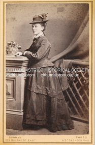
Photograph, Burman's Photographic Rooms, Possibly Jane Shillinglaw, c.1880
Jane Shillinglaw was born at Merri Creek, Victoria, June 14, 1846. She had a son, Joseph Shillinglaw (1863-1865) with an unknown partner. Joseph died as a toddler. She subsequently had a second child, a duaghter, Jane Davidson born 1870 She married William James Sommerville, ten years her junior at hawthorn on June 2, 1887. Jane died at Balwyn, Victoria on June 26, 1893. According to Sands & McDougall Melbourne Directory, Burman's were operating from 209 Bourke St. East and St George's Hall (73 Bourke St. East) from 1879-1885 CARTE-DE-VISITE (cdv) 1857-1890 Cartes-de-visite (cdv's) are the most common form of photograph from the nineteenth century, generally measuring two and a half inches by four and an eighth inches (6.3 x 10.5 cm) when mounted, sepia toned, mounted on a card which was generally printed with the photographer's name and address on the back or beneath the portrait. - Frost, Lenore; Dating Family Photos 1850-1920; Valiant Press Pty. Ltd., Berwick, Victoria 1991marg ball collection, shillinglaw family photo album 1, 1879-1885, 1880, burman's photographer 209 bourke st east and st georges hall melbourne, jane sommerville (nee shillinglaw 1846-1893), unknown -
 Eltham District Historical Society Inc
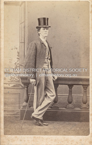
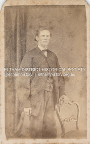
Photograph, Charles Rudd, Possibly Samuel Shillinglaw, c.1871
Samuel Shillinglaw was born at Merri Creek, Victoria, September 27, 1848. He married Agnes McIntosh at Windsor, January 9, 1878 and died at Prahran, September 13, 1925. Photographer Charles Rudd took over from W. Bear on the west side of Chapel Street, Prahan and was in business at this location from 1871-1872 (Sands McDougall Melbourne Directory) A duplicate photo is contained in Album 2 (05664) CARTE-DE-VISITE (cdv) 1857-1890 Cartes-de-visite (cdv's) are the most common form of photograph from the nineteenth century, generally measuring two and a half inches by four and an eighth inches (6.3 x 10.5 cm) when mounted, sepia toned, mounted on a card which was generally printed with the photographer's name and address on the back or beneath the portrait. - Frost, Lenore; Dating Family Photos 1850-1920; Valiant Press Pty. Ltd., Berwick, Victoria 1991marg ball collection, shillinglaw family photo album 1, 1871, 1871-1872, c. rudd & co photographers chapel street prahran, samuel shillinglaw (1848-1925) -
 Eltham District Historical Society Inc
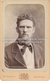
Photograph, Stewart & Co, Believed to be Samuel Shillinglaw, c.1885
Samuel Shillinglaw was born at Merri Creek, Victoria, September 27, 1848. He married Agnes McIntosh at Windsor, January 9, 1878 and died at Prahran, September 13, 1925. CARTE-DE-VISITE (cdv) 1857-1890 Cartes-de-visite (cdv's) are the most common form of photograph from the nineteenth century, generally measuring two and a half inches by four and an eighth inches (6.3 x 10.5 cm) when mounted, sepia toned, mounted on a card which was generally printed with the photographer's name and address on the back or beneath the portrait. - Frost, Lenore; Dating Family Photos 1850-1920; Valiant Press Pty. Ltd., Berwick, Victoria 1991marg ball collection, shillinglaw family photo album 1, 1880-1889, 1885, samuel shillinglaw (1848-1925), stewart & co photographers 217 & 219 bourke st east melbourne -
 Eltham District Historical Society Inc
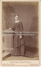
Photograph, Johnstone O'Shannessy & Co, Possibly Caroline Fairlie Stewart (nee Kidd) shortly after her marriage to Alexander Stewart, c.1885
In this image the woman appears wearing a thick wedding band on her left hand. She has a similar resemblance to Sarah Ann Shillinglaw (nee Kidd) and could possibly be a sister. The only sister that the timeline would fit would be Caroline Fairlie Kidd who married Alexander Kirk Stewart 7 Apr 1885 at Richmond, Victoria. The family then lived at Diamond Creek. Johnstone O'Shannessy & Co Photographers operated from 3 Bourke Street from approximately 1865 through 1885. By 1890 they had relocated to 234 Collins Street.The dress is less tailor made and form fitted which appeared from the mid 1880s suggesting this image is circa 1880-1885. There are two other copies of this image in Album 1 (05663) and three in Album 2 (05664) CARTE-DE-VISITE (cdv) 1857-1890 Cartes-de-visite (cdv's) are the most common form of photograph from the nineteenth century, generally measuring two and a half inches by four and an eighth inches (6.3 x 10.5 cm) when mounted, sepia toned, mounted on a card which was generally printed with the photographer's name and address on the back or beneath the portrait. - Frost, Lenore; Dating Family Photos 1850-1920; Valiant Press Pty. Ltd., Berwick, Victoria 1991a.w. burman photographer 209 bourke st east, marg ball collection, shillinglaw family photo album 1, 1865-1886, 1885, caroline fairlie stewart (nee kidd), johnstone o'shannessy & co photographers 3 bourke st melbourne, unknown -
 Eltham District Historical Society Inc
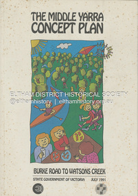
Book, State Government of Victoria, The Middle Yarra Concept Plan: Burke Road to Watsons Creek, July 1991
A draft concept plan developed for the Middle Yarra River between Burke Road and Watsons Creek which includes planning controls, developed and managed to meet the recreation and landscape objectives whilst protecting the natural resourcesa nd cultural heritage. It established a broad framework for more detailed plans and guidelines. Jointly produced by staff from the Victorian Department of Planning and Housing. July 1991.non-fictionA draft concept plan developed for the Middle Yarra River between Burke Road and Watsons Creek which includes planning controls, developed and managed to meet the recreation and landscape objectives whilst protecting the natural resourcesa nd cultural heritage. It established a broad framework for more detailed plans and guidelines. Jointly produced by staff from the Victorian Department of Planning and Housing. July 1991.recreation areas, regional planning, yarra river, watsons creek -
 Eltham District Historical Society Inc
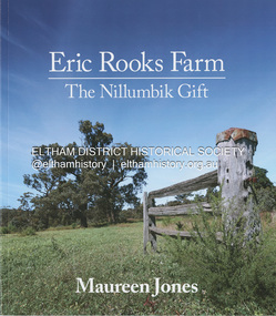
Book, Maureen Jones, Eric Rooks Farm: the Nillumbik gift, 2022
History of the Rooks family and farm, located at 167 Allendale Road, Diamond Creek. The property was first settled in 1865 and held by four generations of the family always retaining its rural landscape. Family archives and historical newspaper reports supplemented with photographs from the collection of Nillumbik Historical Society have contributed to the telling of this family history and history of the property. Hailing from Cambridgeshire England, the Diamond Creek pioneer settler was Isaac Rooks. He, his brothers and descendants are all profiled. The story of the Maroondah Aqueduct which passed through the property is also discussed including the recent development of the Aqueduct trail. More recently managed by Eric Rooks whose story is also represented, Eric donated the property to the National Trust upon his death in 2020 with the condition that a Reserve would be established.93 pagesnon-fictionHistory of the Rooks family and farm, located at 167 Allendale Road, Diamond Creek. The property was first settled in 1865 and held by four generations of the family always retaining its rural landscape. Family archives and historical newspaper reports supplemented with photographs from the collection of Nillumbik Historical Society have contributed to the telling of this family history and history of the property. Hailing from Cambridgeshire England, the Diamond Creek pioneer settler was Isaac Rooks. He, his brothers and descendants are all profiled. The story of the Maroondah Aqueduct which passed through the property is also discussed including the recent development of the Aqueduct trail. More recently managed by Eric Rooks whose story is also represented, Eric donated the property to the National Trust upon his death in 2020 with the condition that a Reserve would be established.diamond creek, rooks family, isaac rooks, maroondah aqueduct, maroondah aqueduct trail -
 Eltham District Historical Society Inc
Photograph, Thomas Wright, Believed to be Samuel Shillinglaw, c.1867
Samuel Shillinglaw Born 27 Sep 1848, Merri Creek, Victoria Died 13 Sep 1925, Prahran, Victoria Thomas Wright, Artist, 52 & 236 Bourke Street East, Melbourne. According to Sands McDougall Melbourne Directory, Thomas Wright operated from 52 Bourke Street East from 1867-1870 and from 236 Bourke Street East from 1865-1870. He was operating from both addresse for the period 1867-1870. CARTE-DE-VISITE (cdv) 1857-1890 Cartes-de-visite (cdv's) are the most common form of photograph from the nineteenth century, generally measuring two and a half inches by four and an eighth inches (6.3 x 10.5 cm) when mounted, sepia toned, mounted on a card which was generally printed with the photographer's name and address on the back or beneath the portrait. - Frost, Lenore; Dating Family Photos 1850-1920; Valiant Press Pty. Ltd., Berwick, Victoria 1991marg ball collection, samuel shillinglaw (1848-1925), shillinglaw family photo album 2, thomas wright photographer 52 & 236 bourke street east, 1867, 1867-1870 -
 Eltham District Historical Society Inc
Album - Photograph Album, J.A. McDonald, Bridge and Road Reconstruction Works, Shire of Eltham, 1952-1962
J.A. McDonald produced this record in the course of his responsibilities as Shire Engineer for Eltham Shire Council.Record of various Shire of Eltham infrastructure works undertaken during the period of 1952-1962 involving bridge and road reconstruction projects, sometimes with Eltham Shire Council Project Reference numbers quoted. It was during this period that a number of significant improvements were made to roads and new bridges constructed within the shire that remain in place as of present day (2022). In many situations, the photos provide a tangible visible record of infrastructure that existed throughout the early days of the Shire. The album was put together by or under the direction of the Shire Engineer, J.A. McDonald.a. gillies, alistair knox park, benchmark studies, bend of islands, blease road, box hill state school, box hill teachers college, box hill tip, bridge construction, bridge street bridge, bridge, brisbane street, brougham steet, bulldozer, cecil street, charis pelling, cherry tree road, city of preston, cr. a. brinkkotter, cr. charis pelling, cranes, cromwell street, diamond creek (creek), diamond street, dixons creek bridge, dixon's creek road, drott, eltham leisure centre, eltham north, eltham police station, eltham, eltham-yarra glen road, f. wood, fitzsimons lane bridge, flat rock road, flood damage, floods, floodwater, footpaths and gutters, ford service garage, g. blair, garden hill, glen park bridge, glenauburn road, grand hotel, haldane road, healesville, healesville-yarra glen road, heidelberg-kinglake road, henley road bridge, henley road, hill property, hurstbridge water scheme, hurstbridge, hurstbridge-arthurs creek road, infrastructure, j. jolly, kangaroo ground, kangaroo ground-queenstown road, kangaroo ground-st andrews road, lilydale shire office, long gully bridge, long gully creek, long gully road, long gully, lower plenty bridge, lower plenty footbridge, lower plenty oval, lower plenty road, lower plenty, main road, methodist church, montmorency, mount pleasant road, new holland, old healesville road, opening ceremony, oxley bridge, para road, paul creek bridge, paul creek road, paul krafeznk, pinnacle lane, plaques, plenty river trail, plenty river, presbyterian church, prof donald thomson, pryor street, railway crossing, railway parade, rattray road, reconstruction works, reichelt avenue, research (vic.), research oval, road construction, rymers corner, shire of eltham, shire of whittlesea, silvan road bridge, silver street bridge, silver street, sir dallas brooks, smedley property, st andrews, steels creek, susan street, tarrawarra, tony carberry, uniting church, upper yarra dam, upper yarra reservoir, w.e. wolf, waterfall property, watsons creek, wattletree road bridge, wattletree road, wattletree road bridge, worlingworth, yarra glen, york street, yow yow creek -
 Eltham District Historical Society Inc
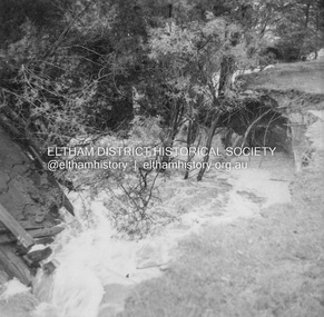
Album - Photograph, J.A. McDonald, Dixons Creek Road, 23 Sep. 1955
Dixons Creek in floodRecord of various Shire of Eltham infrastructure works undertaken during the period of 1952-1962 involving bridge and road reconstruction projects, sometimes with Eltham Shire Council Project Reference numbers quoted. It was during this period that a number of significant improvements were made to roads and new bridges constructed within the shire that remain in place as of present day (2022). In many situations, the photos provide a tangible visible record of infrastructure that existed throughout the early days of the Shire. The album was put together by or under the direction of the Shire Engineer, J.A. McDonald.1955-09-23, bridge construction, dixons creek bridge, dixon's creek road, flood damage, floods, infrastructure, road construction, shire of eltham -
 Eltham District Historical Society Inc
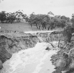
Album - Photograph, J.A. McDonald, Dixons Creek Road, 23 Sep. 1955
Dixons Creek in floodRecord of various Shire of Eltham infrastructure works undertaken during the period of 1952-1962 involving bridge and road reconstruction projects, sometimes with Eltham Shire Council Project Reference numbers quoted. It was during this period that a number of significant improvements were made to roads and new bridges constructed within the shire that remain in place as of present day (2022). In many situations, the photos provide a tangible visible record of infrastructure that existed throughout the early days of the Shire. The album was put together by or under the direction of the Shire Engineer, J.A. McDonald.1955-09-23, bridge construction, dixons creek bridge, dixon's creek road, flood damage, floods, infrastructure, road construction, shire of eltham -
 Eltham District Historical Society Inc
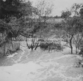
Album - Photograph, J.A. McDonald, Dixons Creek Road, 23 Sep. 1955
Dixons Creek in floodRecord of various Shire of Eltham infrastructure works undertaken during the period of 1952-1962 involving bridge and road reconstruction projects, sometimes with Eltham Shire Council Project Reference numbers quoted. It was during this period that a number of significant improvements were made to roads and new bridges constructed within the shire that remain in place as of present day (2022). In many situations, the photos provide a tangible visible record of infrastructure that existed throughout the early days of the Shire. The album was put together by or under the direction of the Shire Engineer, J.A. McDonald.1955-09-23, bridge construction, dixons creek bridge, dixon's creek road, flood damage, floods, infrastructure, road construction, shire of eltham