Showing 12861 items
matching phillip
-
 Clunes Museum
Book - DIARY, PETER KEMPSON, A PIONEER'S JOURNEY TO EARLY PORT PHILLIP, 1998
THE DIARY OF PETER KEMPSON 1848 - 1849WHITE COVER WITH BLACK PLASTIC SPINE. A PIONEER'S JOURNEY TO EARLY PORT PHILLIP. THE DIARY OF PETER KEMPSON 1848 - 1849non-fictionTHE DIARY OF PETER KEMPSON 1848 - 1849local history, documents, diary, kempson, peter, diary -
 Federation University Historical Collection
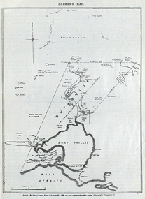
Image, Batman's Map of Port Phillip
Scanned from "The Old Pioneers' Memorial History of Melbourne From the Discovery of Port Phillip to the World War". It is a facsimile map from the House of Commons Reports of Committee.John Batman's map of Port Phillip showing Dutigalla (Batman's Tract), a township reserve, open plains, public common reserve, fresh water"A tract of country [called?] by the native chief of Southern Ausralia to be John Batman 6th June 1935."port phillip bay, john batman, melbourne, iramoo, r. sarsh, river sarsh, river batman, yarra river -
 Phillip Island and District Historical Society Inc.
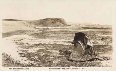
Sepia Photograph, 1920's
This Album was presented to the Earl of Stradbroke by Fathers of Soldiers and Returned Soldiers 16.2.1995. Photo of Kitty Miller Bay, Cowes, Phillip Island, with portion of the Wreck of the Speke - wrecked 2/2/1906Album presented to the Earl of StradbrokeSepia Photograph of Kitty Miller Bay, Phillip Island, with portion of the Wreck of the Speke - wrecked 2/2/1906Rose Series P.3442 Kitty Miller's Bay, Cowes, Phillip Is., Vic.phillip island, wreck of the speke, earl of stradbroke, kitty miller bay -
 Melbourne Tram Museum
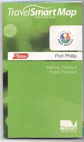
Document, Ministry of Transport, "Travel Smart Map - Port Phillip", 2010
Gives extensive details of walking cycling Public Transport in Port Phillip. Printed 2010. Yields information about Port Phillip transport and other services in 2010Map - pocket - 28 fold - showing walking, cycling and public transport in the City of Port Phillip, using a Melway Map base along with public transport information, Metcard, cycling and walking groups.tramways, melbourne, tram services, bus services, railways, port phillip, cyclists -
 Phillip Island and District Historical Society Inc.
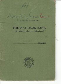
Book, Bank book Shire of Phillip Island Loan No. 9, 1941
Loan of 750 pound from the National Bank to the Shire of Phillip Island. 1941-1952HistoricalSmall soft covered, green coloured bank book containing handwritten entries for debits and credits and balances.533 Shire of Phillip Island Loan in account current with The National Bank of Australasia Limited Cowes Branchshire of phillip island, national bank cowes, banking -
Lakes Entrance Historical Society
Book - Arthur Phillip, Hughes, Thea Stanley, 1982
An account of the life and achievements of Arthur Phillip, commander of the First Fleet, sent to Botany Bay; the relocation to Port Jackson, and the development of the settlement under his governorship. Written for students.An account of the life and achievements of Arthur Phillip, commander of the First Fleet, sent to Botany Bay; the relocation to Port Jackson, and the development of the settlement under his governorship. Written for students.law, government, land settlement -
 Phillip Island and District Historical Society Inc.
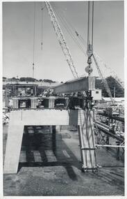
Photographs, Country Roads Board, Phillip Island 2nd Bridge Construction, 1966 - 1969
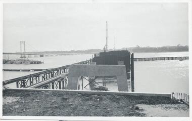
Eight of a collection of 70 photographs taken at the time of the Phillip Island second bridge construction by Country Roads Board & Shire of Bass. Contractor John Holland & Co Pty LtdEight Black & White photographs of the construction of the 2nd Phillip Island Bridge from San Remo to Newhaven - built from 1966 to 1969. Photographs showing various aspects of the construction.351-43: CRB NEG No. 67-1930E. Placing 1st Beam on Span 3. 351-44: CRB NEG No. 67-1930F. 1st Beam on Span 3. 351-45: CRB NEG No. 68-2126H. 351-46: CRB NEG No. 68-2126B. 351-47A: CRB NEG No. 67-2708A. 351-47B: CRB NEG No. 67-2708C. 351-48: CRB NEG No. 67-2708D. 351-49: CRB NEG No. 66-2860Aphillip island 2nd bridge construction, phillip island bridge, country roads board, shire of bass, john holland & co pty ltd, sasha stark -
 Phillip Island and District Historical Society Inc.
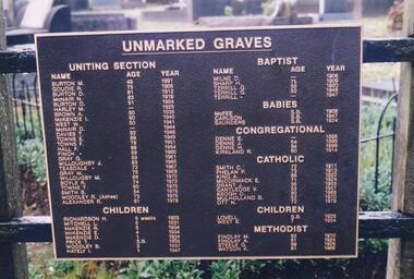
Photograph Album, Kodak, Phillip Island Cemetery, c 1990
The Album was compiled by Nancy McHaffie late 1990's, with the assistance of Edith Jeffery's, with her book "Garden of Memories" and extensive knowledge of Phillip Island. The Cemetery lies back from the road and is surrounded by Manna Gums, rare Peppermint Gums, Blackwoods and other native trees. In all 25 acres of land were set aside as Crown Land in the land settlement of 1868. There are 6.2 acres of wetlands near the cemetery entrance.2 Photographs: 466-08 Notice of the Unmarked Graves. Although the land for the cemetery was granted in 1870, a survey was not made until 1903 hence the existence of unmarked graves. 466-09 A disastrous fire swept through the cemetery in 1943, destroying many structures around the graves - hence the rule "no wooden structures". the Hitching Posts were used for tying up hrses during a funeral service. They were erected in 1912 and now only two remain.phillip island cemetery, nancy mchaffie, edith jeffrey -
 Phillip Island and District Historical Society Inc.
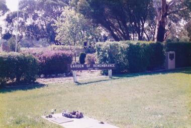
Photograph Album, Kodak, Phillip Island Cemetery, c 1990
The Album was compiled by Nancy McHaffie late 1990's, with the assistance of Edith Jeffery's, with her book "Garden of Memories" and extensive knowledge of Phillip Island. The Cemetery lies back from the road and is surrounded by Manna Gums, rare Peppermint Gums, Blackwoods and other native trees. In all 25 acres of land were set aside as Crown Land in the land settlement of 1868. There are 6.2 acres of wetlands near the cemetery entrance.5 Photographs of the Garden of Remembrance. 466-10 - Garden of Remembrance sign 466-11 - On the 8th November 1990, two Life Members of the League, Mr Eddie Patton and Mr Ken Lang, planted a young seedling from the original Lone Pine from Gallipoli in the Memorial Garden 466-12 - The Returned Servicemens League placed a Flagpole and Granite Stone in the Memorial Garden in memory of the fallen 466-13 & 14 - Garden of Remembrance Plaquesphillip island cemetery, nancy mchaffie, edith jeffrey -
 Phillip Island and District Historical Society Inc.
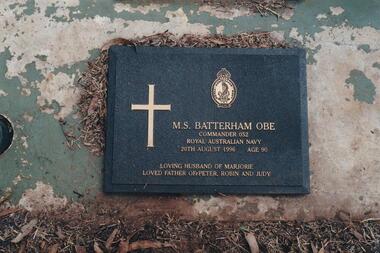
Photograph Album, Kodak, Phillip Island Cemetery, c 1990
The Album was compiled by Nancy McHaffie late 1990's, with the assistance of Edith Jeffery's, with her book "Garden of Memories" and extensive knowledge of Phillip Island. The Cemetery lies back from the road and is surrounded by Manna Gums, rare Peppermint Gums, Blackwoods and other native trees. In all 25 acres of land were set aside as Crown Land in the land settlement of 1868. There are 6.2 acres of wetlands near the cemetery entrance.Lt. Commander M Batterham OBE RANVR was born in 1906 and later attended Geelong Grammar School. First attempt to join RAN was unsuccessful, due to health reasons. In 1942 he joined the Naval Volunteer Reserve. This was the beginning of a naval career which extended to peace-time in Canberra. He was awarded the OBE in 1952 for courage and devotion to duty. Maurice was laid to rest in the lawn section of the cenetery, August 1996 aged 90 years old.phillip island cemetery, nancy mchaffie, edith jeffrey -
 Phillip Island and District Historical Society Inc.
Photograph Album, Kodak, Phillip Island Cemetery, c 1990
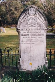
The Album was compiled by Nancy McHaffie late 1990's, with the assistance of Edith Jeffery's, with her book "Garden of Memories" and extensive knowledge of Phillip Island. The Cemetery lies back from the road and is surrounded by Manna Gums, rare Peppermint Gums, Blackwoods and other native trees. In all 25 acres of land were set aside as Crown Land in the land settlement of 1868. There are 6.2 acres of wetlands near the cemetery entrance.466-25: William and Alice Richardson: Alice Barnard married William Richardson at Hawthorn, April 1887. Alice's father Fredrick was a Model Maker employed at the Melbourne Museum. Alice died in childbirth having her third child, Joseph in 1892. Baby Joseph died in April 1893, eight months later at Rhyll. 466-26: The Forrest Family: The Forrest family were amongst our early settlers. The Forrest Caves are named after them. Matthew Forrest arrived by dray from Tarradale on 9th November 1869. He died in 1916 at the age of 75. His Grandson, Peter Forrest Sr. has recorded that Matthew was the first to plant Marum Grass on the Island to prevent erosion.phillip island cemetery, nancy mchaffie, edith jeffery -
 Phillip Island and District Historical Society Inc.
Photograph Album, Kodak, Phillip Island Cemetery, c 1990
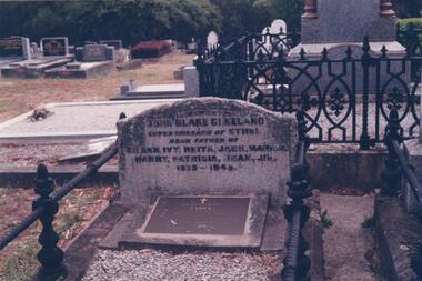
The Album was compiled by Nancy McHaffie late 1990's, with the assistance of Edith Jeffery's, with her book "Garden of Memories" and extensive knowledge of Phillip Island. The Cemetery lies back from the road and is surrounded by Manna Gums, rare Peppermint Gums, Blackwoods and other native trees. In all 25 acres of land were set aside as Crown Land in the land settlement of 1868. There are 6.2 acres of wetlands near the cemetery entrance.466-29: John Blake Cleeland lived in the house his father built, "Woolamai House" in Newhaven. His property ran cattle, horses and angora goats. He had a great love of the sea although he never went to sea. He logged all shipping movements around the Eastern passage of Westernport. He was Captain-in-charge of the Rocket Apparatus Station at Newhaven, which was a rescue service for shipping. 466-30: Eleanor Blake (nee Lucas) came out from Ireland in 1860 together with her husband Edward Hudson Blake and children. For most of her life in Australia, she resided at Hastings. Her youngest daughter Isabella married John Cleeland, both of whom are buried in the cemetery. Eleanor moved from Hastings to "Woolamai House" in later years. 466-31: Margaret Jane Cleeland (nee Kennon) married John Blake Cleeland on May 21st 1903 at South Yarra. She was the daughter of Stanley Stowell Kennon, a farmer and her mother was Isabella (nee Turner). Margaret died in 1909 at the age of 30 years. At the time of her death she was survived by three children: Eileen Henrietta, Ivy Florence & Reita Vermont.phillip island cemetery, nancy mchaffie, edith jeffery, cleeland -
 Phillip Island and District Historical Society Inc.
Photograph Album, Kodak, Phillip Island Cemetery, c 1990
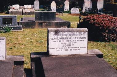
The Album was compiled by Nancy McHaffie late 1990's, with the assistance of Edith Jeffery's, with her book "Garden of Memories" and extensive knowledge of Phillip Island. The Cemetery lies back from the road and is surrounded by Manna Gums, rare Peppermint Gums, Blackwoods and other native trees. In all 25 acres of land were set aside as Crown Land in the land settlement of 1868. There are 6.2 acres of wetlands near the cemetery entrance.466-44: Captain Johan Jansson. Capatain Jansson was born in 1862 and came to Australia on the ship "Nosstaljee" in 1886. In 1887 he came to the Island and started work with Captain Lock. He bought land at Rhyll in 1891 and built a house two years later, now known as Jansson's Cottage. Johan married Evelyn Power.. a daughter of Captain Powell. He purchased the ketch "Swan" and later :Stephen" in 1914. They took chicory, seaweed, hay and other farm produce to Melbourne, returning with general cargo. Captain Jansson died in 1928 aged 66 years. 466-45: Evelyn Jansson. Evelyn was the daughter of Captain Powell. She married Johan Jansson on her 18th birthday. She died 1971 aged 95 years. Their daughter Mavis is buried with Evelyn - died 1971 aged 72 years.phillip island cemetery, johan jansson, evelyn jansson, mavis jansson, nancy mchaffie, edith jeffery -
 Phillip Island and District Historical Society Inc.
Photograph Album, Kodak, Phillip Island Cemetery, c 1990
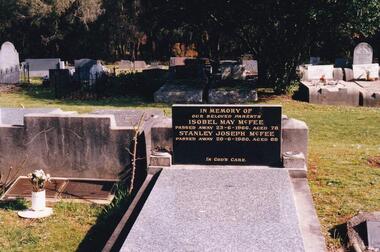
The Album was compiled by Nancy McHaffie late 1990's, with the assistance of Edith Jeffery's, with her book "Garden of Memories" and extensive knowledge of Phillip Island. The Cemetery lies back from the road and is surrounded by Manna Gums, rare Peppermint Gums, Blackwoods and other native trees. In all 25 acres of land were set aside as Crown Land in the land settlement of 1868. There are 6.2 acres of wetlands near the cemetery entrance.Stanley Joseph McFee; Stanley was born at Auburn Grove, Auburn on the 23rd January 1892. He was the seventh son of William and Annie McFee. The McFee family moved to Rhyll in 1894 where Stanley was educated at the Rhyll School. Later he took up farming at Long Point, now known as McFees Road. In 1917 Stanley married Isabell May Cherry who came to Rhyll in 1912 as the school teacher. His wife May supported him in his community activities. Stanley died 1980 aged 88. Isabell May died 1966 aged 78. phillip island cemetery, stanley mcfee, isabell mcfee, nancy mchaffie, edith jeffery -
 Phillip Island and District Historical Society Inc.
Photograph Album, Kodak, Phillip Island Cemetery, c 1889
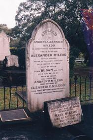
The Album was compiled by Nancy McHaffie late 1990's, with the assistance of Edith Jeffery's, with her book "Garden of Memories" and extensive knowledge of Phillip Island. The Cemetery lies back from the road and is surrounded by Manna Gums, rare Peppermint Gums, Blackwoods and other native trees. In all 25 acres of land were set aside as Crown Land in the land settlement of 1868. There are 6.2 acres of wetlands near the cemetery entrance.Captain McLeod: Captain McLeod and family kept the Post Office at Newhaven. He also built a boat called old "Trusty" and launched it almost opposite Churchill Island. Unfortunately, at a later date, the "Trusty" was the cause of a tragedy. The bottom of the boat had become so encrusted with marine growth that the owner decided to beach her between the jetties at Griffiths point, now San Remo. Before the job was completed the soring gave way and allowed the boat to tip over on her side, causing Captain McLeod to be crushed to death. Died March 3rd 1880 aged 64 years. Also buried in this grave is his wife Susan - died May 24th 1882 aged 62 years. Their son Andrew McLeod died February 21st 1916 aged 60 - loved husband of Elizabeth E McLeod. Alexander was Captain of the "Genista" for 12 years.phillip island cemetery, captain alexander mcleod, susan mcleod, andrew mcleod, nancy mchaffie, edith jeffery -
 Phillip Island and District Historical Society Inc.
Photograph Album, Kodak, Phillip Island Cemetery, c 1990
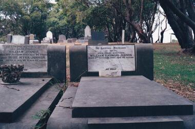
The Album was compiled by Nancy McHaffie late 1990's, with the assistance of Edith Jeffery's, with her book "Garden of Memories" and extensive knowledge of Phillip Island. The Cemetery lies back from the road and is surrounded by Manna Gums, rare Peppermint Gums, Blackwoods and other native trees. In all 25 acres of land were set aside as Crown Land in the land settlement of 1868. There are 6.2 acres of wetlands near the cemetery entrance.Two photos: a) Two graves - William Jenner & Elsie Myra Jenner. William died Oct 1957 aged 73 and Elsie died April 1968 aged 82. - William Raymond Jenner - son of William & Elsie - died Oct 1951 aged 42 years. b) Close up of William & Elsie grave. William had a farm at Ventnor, grew onions and chicory and was always willing to help out or lend any farming machinery. William was a member of the Ventnor School committee and Ventnor Hall committee. He was married to Elsie Churchill of Kilcunda and they had five children.phillip island cemetery, william jenner, elsie jenner, nancy mchaffie, edith jeffery -
 Phillip Island and District Historical Society Inc.
Photograph Album, Kodak, Phillip Island Cemetery, c 1990
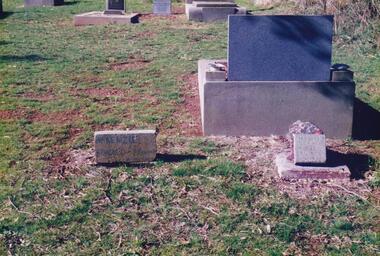
The Album was compiled by Nancy McHaffie late 1990's, with the assistance of Edith Jeffery's, with her book "Garden of Memories" and extensive knowledge of Phillip Island. The Cemetery lies back from the road and is surrounded by Manna Gums, rare Peppermint Gums, Blackwoods and other native trees. In all 25 acres of land were set aside as Crown Land in the land settlement of 1868. There are 6.2 acres of wetlands near the cemetery entrance.The McKenzie Children: Late one night in 1934, Mr Bryant West and Mr Loton heard cries for help from the vicinity of the Cowes Jetty. Attempts were made to save a woman and the children. Sadly only the adult could be rescued. The three young bodies were later recovered and buried in the cemetery. Parents: Ronald & Ena McKenzie - Children: Ronald aged 5 years, Ena Roma aged 4 years and Douglas Forbes aged 1 year. phillip island cemetery, the mckenzie children, nancy mchaffie, edith jeffery -
 Phillip Island and District Historical Society Inc.
Photographs, Country Roads Board, Phillip Island 2nd Bridge Construction, 1966 - 1969
Fifteen photographs from a collection of 70 taken at the construction of Phillip Island 2nd Bridge from 1966 - 1969 by Country Roads Board and Shire of Bass. Contractor John Holland & Co Pty Ltd.Fifteen Black & White photographs of the construction of the Phillip Island 2nd Bridge from 1966 - 1969 by Country Roads Board. Various photos of materials, machinery and people involved in the construction.351-50: CRB NEG No. 66-2860G. 351-51: CRB NEG No. 67-2866. 351-52: CRB NEG No. 67-2867B. 351-53: CRB NEG No. 66-2958A. 351-54: CRB NEG No. 66-2958B. 351-55: CRB NEG No. 67-3070E. 351-56: CRB NEG No. 67-3070F. 351-57: CRB NEG No. 64-3280B. 351-58: CRB NEG No. 67-3356G. 351-59: CRB NEG No. 66-3462D. 351-60: CRB NEG No. 66-3465G. 351-61: CRB NEG No. 66-3466D. 351-62: CRB NEG No. 67-3535D. 351-63: CRB NEG No. 67-3535H. 351-64: CRB NEG No. 67-3535M.phillip island 2nd bridge construction, phillip island bridge (1969), country roads board, shire of bass, john holland & co pty ltd, sasha stark -
 Flagstaff Hill Maritime Museum and Village
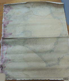
Document - Chart, Admiralty Office, Port Phillip, 1899
Accurate charts were imperative for sea farers to sail their vessels safely from one side of the world to another. The British Admiralty published many charts and updated them frequently. Specialists were employed to gather information such as depth soundings to give the navigator as many helps as possible. At regular intervals the charts had to be updated with the amount of adjustment needed to a compass to allow for magnetic variation.This chart is significant for its association with incoming and outgoin ships for trade and passengers in the late 19th century.Admiralty Chart of Port Phillip, Victoria, South Coast of Australia. It shows navigation buoys, lighthouses, tides and money other details. It was surveyed by Commander Henry L. Cox R.N. in 1864. Published by Admiralty August 19th 1865. Corrections were made by Staff Commander E.J. Stanley R.N. in 1874. The West Channel was surveyed b J.B. Mason , Engineer, in 1899. Published and cartographed in Admiralty, London, England in 1897, supervised by Capt G H Richards R N Hydrographer. Chart was updated in 1899. Sold by W D Potter Agent for Admiralty Charts 145 minorities.Printed: "Port Phillip" "Australia - South Coast, Victoria"flagstaff hill, warrnambool, maritime-museum, flagstaff hill maritime museum & village, shipwreck coast, chart, australia, south coast, port phillip, admiralty, 1899, navigation, cartography, cartographer -
 Phillip Island and District Historical Society Inc.
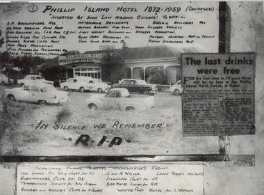
Photograph, Bryant West, 1959
One of a collection of over 400 photographs in an album commenced in 1960 and presented to the Phillip Island & Westernport Historical Society by the Shire of Phillip IslandBlack & White Photograph of Phillip Island Hotel. Nine cars parked at front. Inserted newspaper clipping, 'the last drinks were free' due to the Licensing Court refusing to renew the license on the ground of its disrepair.Melbourne Bitter Phillip Island Hotel. Names of Associations. 'In silence we remember R.I.P.' Newspaper clipping.local history, photography, photographs, phillip island hotel, hotels, motor cars, john jenner, bryant west -
 Phillip Island and District Historical Society Inc.
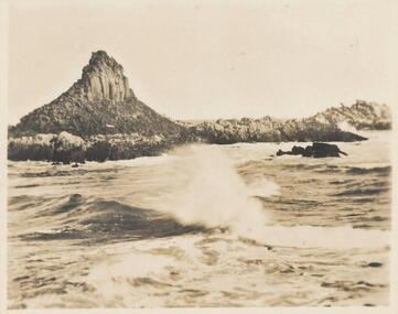
Photograph - Post Card, 1960's
Donated by S. Serpell of Serpell & Reid families, SandringhamSepia Photo of Pyramid Rock, Phillip IslandPyramid Rock, Phillip Islandphillip island -
 Ringwood and District Historical Society
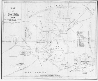
Photograph, Map of Melbourne & Vicinity - 1853. Survey of Port Phillip. Plan in Bonwick's "Settlement of Port Phillip"
Catalogue card reads, 'Map of Melbourne & Vicinity - 1853. Survey of Port Phillip. Plan in Bonwick's "Settlement of Port Phillip"'. -
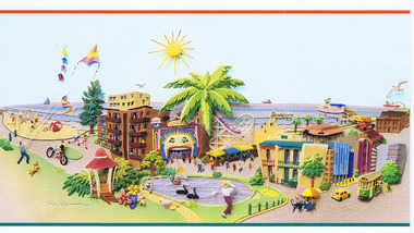 St Kilda Historical Society
Postcard, Raymond Besserdon original design, Published by the City of Port Phillip
postcard coloured. Graphic representation of Luna Park and environs.Port Phillip Alive! -
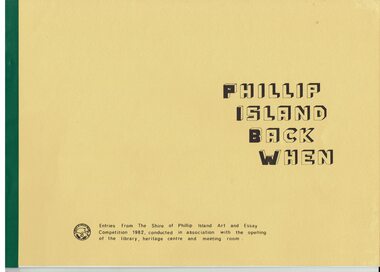 Phillip Island and District Historical Society Inc.
Booklet, Phillip Island Back when 1982 Art and Essay Competition, 1984
The competition was to increase awareness of the pioneering of Phillip Island. 155 entries were received and winners were compiled in the booklet. Art competition winners were Open- Frances Reith and Maree Chaston. Secondary- Neil McRae and Shannon Condick. Primary- Laurie Chisholm and Paul Matthews. Essay Competition winners were Open- Patsy Hunt and Audrey Nicol.. Secondary- Judy Nicol and Cameron Ashe. Primary- Joanne Scrase and Richard Patching.HistoricalLarge yellow coloured booklet with green binding with typed pages, photos and drawings. Also a draft copy of the booklet pre printing which has typed sections pasted onto pages.Snippets of Phillip Island History. Entries from The Shire of Phillip Island Art and Essay competition 1982, conducted in association with the opening of the library, heritage centre and meeting room.chicory industry, the speke, phillip island cemetery, swimming baths, churchill island, ventnor state school, ventnor hall, killara ferry, motor racing -
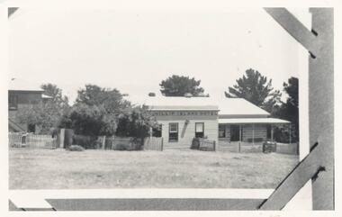 Phillip Island and District Historical Society Inc.
Photograph, Mid 20th Century
One of 20 photographs/postcards donated by Mary KarneyBlack & White photograph copy of the Phillip Island HotelOn back: "Phillip Ils Hotelphillip island hotel, hotels, cowes hotels phillip island, mary karney -
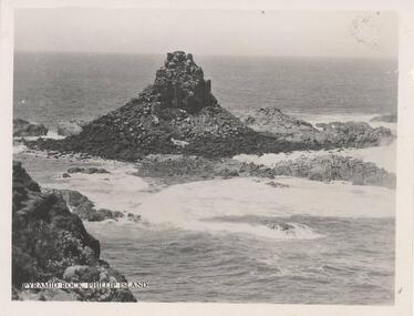 Phillip Island and District Historical Society Inc.
Photograph, 1940's
One of a collection of 15 photographs/postcards donated by Lois MullinsBlack & White photograph of Pyramid Rock, Phillip Island."Pyramid Rock, Phillip Island"pyramid rocks phillip island, phillip island coastline, rock formation phillip island, lois mullins -
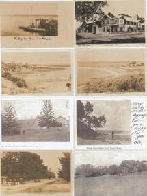 Phillip Island and District Historical Society Inc.
Photograph - Post Cards, Rose Series et al, Early 20th Century
One of 15 A3 pages with copies of postcards on each page. From The Shirley Jones Collection.Copies of Postcards: Left side from top to bottom: View of Phillip Island from San Remo Jetty. The Beach at Rhyll, Phillip Island. The Isle of Wight Hotel, Cowes, Phillip Island. The Beach Road at Cowes, Phillip Island. Right side from top to bottom: The Isle of Wight Hotel, Cowes, Phillip Island. View at Rhyll, Phillip Island. Man of beach at Eastern Rocks Phillip Island, Forest Reserve Cowes, Phillip Island.Left side from top to bottom. Photograph 1 - "Phillip Island from San Remo" Photograph 2 - "The Rose Series P 3431 The Beach Rhyll Phillip Island Vic". Photograph 3 - "Isle of Wight Hotel Cowes Phillip Island". Photograph 4 - "The Rose Series P674 The Beach Road Cowes Phillip Island Victoria". Right side from top to bottom. Photograph 1 - "Photo Shop Series, Isle of Wight Hotel Cowes". Photograph 2 - "The Rose Series P3419 View at Rhyll Phillip Island Vic.". Photograph 3 - "Eastern Rocks (Smiths Point) Phillip Island" Message written on the side. Photograph 4 - "Forest Reserve Cowes".the isle of wight hotel cowes phillip island, sand remo jetty, jetty san remo, rhyll phillip island, beach road cowes, eastern rocks smiths point phillip island, forrest reserve phillip island, shirley jones collection, thelma astbury -
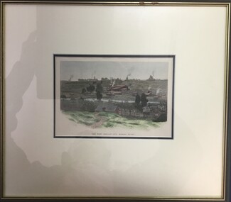 Clunes Museum
Print, THE PORT PHILLIP CO'S MINING PLANT
1. REPRODUCTION OF HAND COLOURED LITHOGRAPH POSSIBLY REPRODUCED FROM A BOOK. IMAGE DEPICTS THE PORT PHILLIP COMPANY'S MINE BUILDINGS. MOUNTED ON BUFF CARDBOARD WITH MATT FRONT. 2. FRAMED COPY OF .1, GREEN TIMBER FRAME WITH GOLD HIGHLIGHT, BUFF MATT, GLASSTHE PORT PHILLIP CO'S MINING PLANT ON BACK OF .2 "GENUINE ANTIQUARIAN PRINT" DATE 1885; LECKIE GALLERY, MALDON RINGWOOD FRAMING GALLERYport phillip mines, clunes, mine buildings, lithograph -
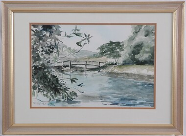 Glenelg Shire Council Cultural Collection
Painting, Phillip Petrie, Langley's Bridge, 1990
Depiction of a bridge over a creek edged with trees. On left are the branches of a tree with grey-green leaves. The creek fills the lower centre area of the image, painted in pale blue, grey, highlights of white and darker areas of dark blue. The wooden rail bridge curves in an even arch in centre of image. On right is a bank rising from the creek, with large tree with pale grey-green foliage and a tree with darker olive foliage. The background shows what could be hills and the sky is very pale blue. Mounted in a double matt (white on orange), framed under glass in wooden frame with gold details.Front: Phillip Petrie 90 (lower left) (grey paint). Back: "Langley's Bridge" watercolour. 570 x 420 mm $150.00 -
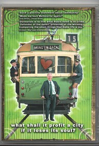 Melbourne Tram Museum
Film - Compact Diskette with video, Phillip Donnellan, "Bring 'em Back!", 2010
DVD - CD with video in a plastic case with cover, titled "Bring 'em Back!" - a film by Phillip Donnellan on the demise on tram conductors in Melbourne and a possible revival. See Key Associations for people involved. Made 2010, running time 49mins.See back for additional handwriting.trams, tramways, films, conductors, melbourne