Showing 227 items matching "photographic equipment"
-
 Flagstaff Hill Maritime Museum and Village
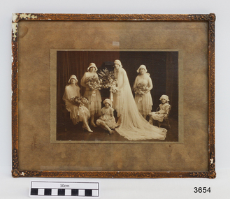
Photograph - Wedding group, c. 1929
This wedding photograph shows the bridal party and bride-to-be, Gladys Forsyth. The wedding was held in Ballarat. The photograph was donated to Flagstaff Hill Maritime Village by the family of Doctor William Roy Angus, Surgeon and Oculist. It is part of the “W.R. Angus Collection” that includes historical medical equipment, surgical instruments and material once belonging to Dr Edward Ryan and Dr Thomas Francis Ryan, (both of Nhill, Victoria) as well as Dr Angus’ own belongings. The Collection’s history spans the medical practices of the two Doctors Ryan, from 1885-1926 plus that of Dr Angus, up until 1969. ABOUT THE “W.R.ANGUS COLLECTION” Doctor William Roy Angus M.B., B.S., Adel., 1923, F.R.C.S. Edin.,1928 (also known as Dr Roy Angus) was born in Murrumbeena, Victoria in 1901 and lived until 1970. He qualified as a doctor in 1923 at University of Adelaide, was Resident Medical Officer at the Royal Adelaide Hospital in 1924 and for a period was house surgeon to Sir (then Mr.) Henry Simpson Newland. Dr Angus was briefly an Assistant to Dr Riddell of Kapunda, then commenced private practice at Curramulka, Yorke Peninsula, SA, where he was physician, surgeon and chemist. In 1926, he was appointed as new Medical Assistant to Dr Thomas Francis Ryan (T.F. Ryan, or Tom), in Nhill, Victoria, where his experiences included radiology and pharmacy. In 1927 he was Acting House Surgeon in Dr Tom Ryan’s absence. Dr Angus had become engaged to Gladys Forsyth and they decided he would take time to further his studies overseas in the UK in 1927. He studied at London University College Hospital and at Edinburgh Royal Infirmary and in 1928, was awarded FRCS (Fellow from the Royal College of Surgeons), Edinburgh. He worked his passage back to Australia as a Ship’s Surgeon on the on the Australian Commonwealth Line’s T.S.S. Largs Bay. Dr Angus married Gladys in 1929, in Ballarat. (They went on to have one son (Graham 1932, born in SA) and two daughters (Helen (died 12/07/1996) and Berenice (Berry), both born at Mira, Nhill ) Dr Angus was a ‘flying doctor’ for the A.I.M. (Australian Inland Ministry) Aerial Medical Service in 1928 . The organisation began in South Australia through the Presbyterian Church in that year, with its first station being in the remote town of Oodnadatta, where Dr Angus was stationed. He was locum tenens there on North-South Railway at 21 Mile Camp. He took up this ‘flying doctor’ position in response to a call from Dr John Flynn; the organisation was later known as the Flying Doctor Service, then the Royal Flying Doctor Service. A lot of his work during this time involved dental surgery also. Between 1928-1932 he was surgeon at the Curramulka Hospital, Yorke Peninsula, South Australia. In 1933 Dr Angus returned to Nhill where he’d previously worked as Medical Assistant and purchased a share of the Nelson Street practice and Mira hospital from Dr Les Middleton one of the Middleton Brothers, the current owners of what was once Dr Tom Ryan’s practice. Dr L Middleton was House Surgeon to the Nhill Hospital 1926-1933, when he resigned. [Dr Tom Ryan’s practice had originally belonged to his older brother Dr Edward Ryan, who came to Nhill in 1885. Dr Edward saw patients at his rooms, firstly in Victoria Street and in 1886 in Nelson Street, until 1901. The Nelson Street practice also had a 2 bed ward, called Mira Private Hospital ). Dr Edward Ryan was House Surgeon at the Nhill Hospital 1884-1902 . He also had occasions where he successfully performed veterinary surgery for the local farmers too. Dr Tom Ryan then purchased the practice from his brother in 1901. Both Dr Edward and Dr Tom Ryan work as surgeons included eye surgery. Dr Tom Ryan performed many of his operations in the Mira private hospital on his premises. He too was House Surgeon at the Nhill Hospital 1902-1926. Dr Tom Ryan had one of the only two pieces of radiology equipment in Victoria during his practicing years – The Royal Melbourne Hospital had the other one. Over the years Dr Tom Ryan gradually set up what was effectively a training school for country general-practitioner-surgeons. Each patient was carefully examined, including using the X-ray machine, and any surgery was discussed and planned with Dr Ryan’s assistants several days in advance. Dr Angus gained experience in using the X-ray machine there during his time as assistant to Dr Ryan. Dr Tom Ryan moved from Nhill in 1926. He became a Fellow of the Royal Australasian College of Surgeons in 1927, soon after its formation, a rare accolade for a doctor outside any of the major cities. He remained a bachelor and died suddenly on 7th Dec 1955, aged 91, at his home in Ararat. Scholarships and prizes are still awarded to medical students in the honour of Dr T.F. Ryan and his father, Dr Michael Ryan, and brother, John Patrick Ryan. ] When Dr Angus bought into the Nelson Street premises in Nhill he was also appointed as the Nhill Hospital’s Honorary House Surgeon 1933-1938. His practitioner’s plate from his Nhill surgery states “HOURS Daily, except Tuesdays, Fridays and Saturday afternoons, 9-10am, 2-4pm, 7-8pm. Sundays by appointment”. This plate is now mounted on the doorway to the Port Medical Office at Flagstaff Hill Maritime Village, Warrnambool. Dr Edward Ryan and Dr Tom Ryan had an extensive collection of historical medical equipment and materials spanning 1884-1926 and when Dr Angus took up practice in their old premises he obtained this collection, a large part of which is now on display at the Port Medical Office at Flagstaff Hill Maritime Village in Warrnambool. During his time in Nhill Dr Angus was involved in the merging of the Mira Hospital and Nhill Public Hospital into one public hospital and the property titles passed on to Nhill Hospital in 1939. In 1939 Dr Angus and his family moved to Warrnambool where he purchased “Birchwood,” the 1852 home and medical practice of Dr John Hunter Henderson, at 214 Koroit Street. (This property was sold in1965 to the State Government and is now the site of the Warrnambool Police Station. ). The Angus family was able to afford gardeners, cooks and maids; their home was a popular place for visiting dignitaries to stay whilst visiting Warrnambool. Dr Angus had his own silk worm farm at home in a Mulberry tree. His young daughter used his centrifuge for spinning the silk. Dr Angus was appointed on a part-time basis as Port Medical Officer (Health Officer) in Warrnambool and held this position until the 1940’s when the government no longer required the service of a Port Medical Officer in Warrnambool; he was thus Warrnambool’s last serving Port Medical Officer. (The duties of a Port Medical Officer were outlined by the Colonial Secretary on 21st June, 1839 under the terms of the Quarantine Act. Masters of immigrant ships arriving in port reported incidents of diseases, illness and death and the Port Medical Officer made a decision on whether the ship required Quarantine and for how long, in this way preventing contagious illness from spreading from new immigrants to the residents already in the colony.) Dr Angus was a member of the Australian Medical Association, for 35 years and surgeon at the Warrnambool Base Hospital 1939-1942, He served as a Surgeon Captain during WWII 1941-45, in Ballarat, Victoria, and in Bonegilla, N.S.W., completing his service just before the end of the war due to suffering from a heart attack. During his convalescence he carved an intricate and ‘most artistic’ chess set from the material that dentures were made from. He then studied ophthalmology at the Royal Melbourne Eye and Ear Hospital and created cosmetically superior artificial eyes by pioneering using the intrascleral cartilage. Angus received accolades from the Ophthalmological Society of Australasia for this work. He returned to Warrnambool to commence practice as an ophthalmologist, pioneering in artificial eye improvements. He was Honorary Consultant Ophthalmologist to Warrnambool Base Hospital for 31 years. He made monthly visits to Portland as a visiting surgeon, to perform eye surgery. He represented the Victorian South-West subdivision of the Australian Medical Association as its secretary between 1949 and 1956 and as chairman from 1956 to 1958. In 1968 Dr Angus was elected member of Spain’s Barraquer Institute of Barcelona after his research work in Intrasclearal cartilage grafting, becoming one of the few Australian ophthalmologists to receive this honour, and in the following year presented his final paper on Living Intrasclearal Cartilage Implants at the Inaugural Meeting of the Australian College of Ophthalmologists in Melbourne In his personal life Dr Angus was a Presbyterian and treated Sunday as a Sabbath, a day of rest. He would visit 3 or 4 country patients on a Sunday, taking his children along ‘for the ride’ and to visit with him. Sunday evenings he would play the pianola and sing Scottish songs to his family. One of Dr Angus’ patients was Margaret MacKenzie, author of a book on local shipwrecks that she’d seen as an eye witness from the late 1880’s in Peterborough, Victoria. In the early 1950’s Dr Angus, painted a picture of a shipwreck for the cover jacket of Margaret’s book, Shipwrecks and More Shipwrecks. She was blind in later life and her daughter wrote the actual book for her. Dr Angus and his wife Gladys were very involved in Warrnambool’s society with a strong interest in civic affairs. Their interests included organisations such as Red Cross, Rostrum, Warrnambool and District Historical Society (founding members), Wine and Food Society, Steering Committee for Tertiary Education in Warrnambool, Local National Trust, Good Neighbour Council, Housing Commission Advisory Board, United Services Institute, Legion of Ex-Servicemen, Olympic Pool Committee, Food for Britain Organisation, Warrnambool Hospital, Anti-Cancer Council, Boys’ Club, Charitable Council, National Fitness Council and Air Raid Precautions Group. He was also a member of the Steam Preservation Society and derived much pleasure from a steam traction engine on his farm. He had an interest in people and the community He and his wife Gladys were both involved in the creation of Flagstaff Hill, including the layout of the gardens. After his death (28th March 1970) his family requested his practitioner’s plate, medical instruments and some personal belongings be displayed in the Port Medical Office surgery at Flagstaff Hill Maritime Village, and be called the “W. R. Angus Collection”. The W.R. Angus Collection is significant for still being located at the site it is connected with, Doctor Angus being the last Port Medical Officer in Warrnambool. The collection of medical instruments and other equipment is culturally significant, being an historical example of medicine from late 19th to mid-20th century. Dr Angus assisted Dr Tom Ryan, a pioneer in the use of X-rays and in ocular surgery. Framed, glass covered photograph, sepia colour, Dr.W.R. Angus’ bride-to-be (Gladys) with her three (3) bridesmaids and two (2) flower girls. Frame’s edging is embossed with roses in the corners. Photograph was framed in Adelaide. Framer’s details are on the back of the frame.Label on back of frame with Framer’s details “James Hooper, Picture Framer, 120 Rundle St. Adelaide” flagstaff hill, warrnambool, shipwrecked coast, flagstaff hill maritime museum, maritime museum, shipwreck coast, flagstaff hill maritime village, great ocean road, dr w r angus, gladys forsyth, angus - forsyth wedding, marriage of dr w.r. angus, wedding photograph, photographic record wedding 1929 -
 Flagstaff Hill Maritime Museum and Village
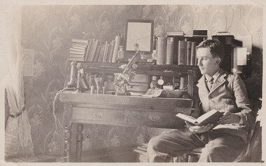
Photograph - Portrait, William Roy Angus, c. 1920's
This is a photograph of (William) Roy Angus, at his desk as a medical student in Adelaide, South Australia. It was donated to Flagstaff Hill Maritime Museum and Village by the family. He later qualified as Doctor William Roy Angus, Surgeon and Oculist. It is part of the “W.R. Angus Collection” which includes historical medical equipment, surgical instruments and materials once belonging to Dr Edward Ryan and Dr Thomas Francis Ryan, (both of Nhill, Victoria) as well as Dr Angus’ own belongings. The Collection’s history spans the medical practices of the two Doctors Ryan, from 1885-1926 plus that of Dr Angus, up until 1969. ABOUT THE “W.R. ANGUS COLLECTION” updated 20-01-2023 Doctor William Roy Angus M.B., B.S., Adel., 1923, F.R.C.S. Edin.,1928 (also known as Dr Roy Angus) was born in Murrumbeena, Victoria on 28th June 1901 and lived until 1970. He qualified as a doctor, M.B.B.S. (Bachelor of Medicine-Bachelor of Surgery) in the 1923 at University of Adelaide, was Resident Medical Officer at the Royal Adelaide Hospital in 1924 and for a period was house surgeon to Sir (then Mr.) Henry Simpson Newland, from whom he acquired his interest in plastic surgery. He was also House Surgeon to Dr J.J. O’Grady, under whom he did his early Ophthalmological training. Dr Angus was briefly an Assistant to Dr Riddell of Kapunda, then commenced private practice at Curramulka, Yorke Peninsula, SA, where he was a physician, surgeon and chemist. In 1926, he was appointed as the new Medical Assistant to Dr Thomas Francis Ryan (T.F. Ryan, or Tom), in Nhill, Victoria, whose practice had been established by his brother, Dr Edward Ryan. Consequently, a considerable amount of eye work was done. Dr Angus’ experiences included radiology and pharmacy. In 1927 he was Acting House Surgeon in Dr Tom Ryan’s six-month trip abroad. Dr Angus had become engaged to Gladys Forsyth and they decided he further his studies overseas in the UK in 1927, sailing in the ship SS Banffshire. He studied at London University College Hospital and at Edinburgh Royal Infirmary and in 1928, was awarded FRCS (Fellow from the Royal College of Surgeons), Edinburgh, Scotland. He worked his passage back to Australia as a Ship’s Surgeon on the Australian Commonwealth Line T.S.S. Largs Bay, which was purchased by the White Star Line in 1928. He returned to South Australia, where he practised general surgery 1928-1932. He was a surgeon at the Curramulka Hospital, Yorke Peninsula, South Australia. Dr Angus was a ‘flying doctor’ for the A.I.M. (Australian Inland Ministry) Aerial Medical Service in 1928. Its first station was in the remote town of Oodnadatta, where Dr Angus was stationed. He was locum tenens there on North-South Railway at 21 Mile Camp. He took up this ‘flying doctor’ position in response to a call from Dr John Flynn; the organisation was later known as the Flying Doctor Service, then the Royal Flying Doctor Service. His work during this time involved general surgery, eye work, plastic surgery, radiology, pathology and even dental surgery. Dr Angus married Gladys in 1929, in Ballarat. (They went on to have one son (Graham 1932, born in SA) and two daughters (Helen (died 12/07/1996) and Berenice (Berry), both born at Mira, Nhill ). According to Berry, her mother Gladys made a lot of their clothes. She was very talented and did some lovely embroidery including lingerie for her trousseau and beautifully handmade baby clothes. In 1933 Dr Angus returned to Nhill and purchased a share of the Nelson Street practice and Mira hospital (a 2-bed ward at the Nelson Street Practice) from Dr Les Middleton one of the Middleton Brothers, the current owners of what previously once Dr Tom Ryan’s practice, where Dr Angus was previously Medical Assistant. Dr Tom and his brother had worked as surgeons including in eye surgery. Dr Tom Ryan performed many of his operations in the Mira private hospital on his premises. He had been House Surgeon at the Nhill Hospital from 1902-1926. Dr Tom Ryan had one of the only two pieces of radiology equipment in Victoria during his practicing years – The Royal Melbourne Hospital had the other one. Over the years Dr Tom Ryan had gradually set up what was effectively a training school for country general-practitioner-surgeons. Each patient was carefully examined, including using the X-ray machine, and any surgery was discussed and planned with Dr Ryan’s assistants several days in advance. Dr Angus gained experience in using the X-ray machine there during his time as assistant to Dr Ryan. The doctors Ryan were related to the Ryan Eye Doctors in Melbourne. When Dr Angus bought into the Nelson Street premises in Nhill he was also appointed as the Nhill Hospital’s Honorary House Surgeon 1933-1938. His practitioner’s plate from his Nhill surgery is now mounted on the doorway to the Port Medical Office at Flagstaff Hill Maritime Village, Warrnambool. When Dr Angus took up practice in Dr Edward and Dr Tom Ryan’s old premises, he obtained their extensive collection of historical medical equipment and materials spanning 1884-1926. A large part of this collection is now on display at the Port Medical Office at Flagstaff Hill Maritime Village in Warrnambool. In 1939 Dr Angus and his family moved to Warrnambool where he purchased “Birchwood,” the 1852 home and medical practice of Dr John Hunter Henderson, at 214 Koroit Street. (This property was sold in1965 to the State Government and is now the site of the Warrnambool Police Station. and an ALDI store is on the land that was once their tennis court). The Angus family could afford gardeners, cooks and maids; their home was a popular place for visiting dignitaries to stay whilst visiting Warrnambool. Dr Angus had his own silkworm farm at home in a Mulberry tree. His young daughter used his centrifuge for spinning the silk. Dr Angus was appointed on a part-time basis as Port Medical Officer (Health Officer) in Warrnambool and held this position until the 1940s when the government no longer required the service of a Port Medical Officer in Warrnambool; he was thus Warrnambool’s last serving Port Medical Officer. (Masters of immigrant ships arriving in port reported incidents of diseases, illness and death and the Port Medical Officer made a decision on whether the ship required Quarantine and for how long, in this way preventing contagious illness from spreading from new immigrants to the residents already in the colony.) Dr Angus was a member of the Australian Medical Association, for 35 years and a surgeon at the Warrnambool Base Hospital from 1939-1942, Soon after his move to Warrnambool, war was declared. Dr Angus joined the Australian Department of Defence as a Surgeon Captain during WWII 1942-45, in Ballarat, Victoria, and in Bonegilla, N.S.W., at 106 A.G.H., completing his service just before the end of the war due to suffering from a heart attack. During his twelve moth convalescence and rehabilitation, he carved an intricate and ‘most artistic’ chess set from the material that dentures were made from. He returned to Warrnambool to commence practice as an ophthalmologist, pioneering artificial eye improvements. He was an Honorary Consultant Ophthalmologist at Warrnambool Base Hospital for 31 years. He made monthly visits to Portland as a visiting surgeon, to perform eye surgery. He represented the Victorian South-West subdivision of the Australian Medical Association as its secretary between 1949 and 1956 and as chairman from 1956 to 1958. Altogether he had interests in nine various medical organisations. In his personal life, Dr Angus was a Presbyterian and treated Sunday as a Sabbath, a day of rest. He would visit 3 or 4 country patients on a Sunday, taking his children along ‘for the ride’ and visiting with him. Sunday evenings he would play the pianola or piano and sing Scottish songs to his family. He loved Scottish music. He owned a farm in the Heytesbury district, where he found his hobbies of metalwork and carpentry useful in the workshop. He also enjoyed painting, mainly watercolour, and took part in many exhibitions. One of Dr Angus’ patients was Margaret MacKenzie, author of a book on local shipwrecks that she’d seen as an eyewitness from the late 1880’s in Peterborough, Victoria. In the early 1950’s Dr Angus, painted a picture of a shipwreck for the cover jacket of Margaret’s book, Shipwrecks and More Shipwrecks. She was blind in later life and her daughter wrote the actual book for her. Dr Angus and his wife Gladys were very involved in Warrnambool’s society with a strong interest in civic affairs. He had an interest in people and the community They were both involved in the creation of Flagstaff Hill, including the layout of the gardens. After serving in the Army, Dr Angus studied ophthalmology and became a Clinical Assistant at the Royal Melbourne Eye and Ear Hospital. He had been interested in an article on cartilage grafting by Dr Lyndon Peer of St. Barnabas Medical Centre, New Jersey, U.S., which he happened to see in a dental journal. After thought and research, Dr Angus decided to try his idea of living intrascleral implants and was able to present a paper on his results at the Combined Scientific Meeting of the O.S.A. at Surfers’ Paradise in 1962. This was followed by a further report on the results of the different methods used, given in Adelaide at the O.S.A. meeting in 1965. In 1967, during an extended holiday abroad, he was invited to spend time at the Barraquer Institute in Barcelona. While there, showed a film of his operation with slides and, translated by Professor Barraquer, gave an abridged lecture. He was elected as a member of the Instituto Barraquer, one of only a few Australians to receive the honour. He received many requests for copies of his paper. He was also invited to lecture and show the films in England and at the St Barnabas Medical Centre in New Jersey. He completed his work on Living Intrascleral Implants and gave his final paper and film Inaugural Meeting of the Australian College of Ophthalmologists in Melbourne in October 1969. Angus received accolades from the Ophthalmological Society of Australasia for this work. Two weeks after presenting his paper in Melbourne in 1969 Dr Angus became critically ill. He died on 28th March 1970. His family requested his practitioner’s plate, medical instruments and some personal belongings to be displayed in the Port Medical Office surgery at Flagstaff Hill Maritime Village, and be called the “W. R. Angus Collection”. The W.R. Angus Collection is significant for still being located at the site it is connected with, Doctor Angus being the last Port Medical Officer in Warrnambool. The collection of medical instruments and other equipment is culturally significant, being a historical example of medicine from the late 19th to mid-20th century. Dr Angus assisted Dr Tom Ryan, a pioneer in the use of X-rays and in ocular surgery. Photograph, black and white, of (William) Roy Angus as a student at his desk in his study, pre 1923. Part of the W.R. Angus Collection.flagstaff hill, warrnambool, shipwrecked coast, flagstaff hill maritime museum, maritime museum, shipwreck coast, flagstaff hill maritime village, great ocean road, dr w r angus, dr ryan, surgical instrument, t.s.s. largs bay, warrnambool base hospital, nhill base hospital, mira hospital, flying doctor, roy angus photograph, roy angus student, photographic history, w.r. angus collection, w.r. angus biography, pianola, piano, scotland, scottish music -
 Bendigo Military Museum
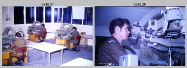
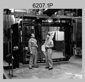
Photograph - Photogrammetric Equipment – Army Survey Regiment, Bendigo and School of Military Survey Bonegilla, c1960s to c1980s
This is a set of 14 photographs of RA Svy technicians operating photogrammetric equipment in Air Survey Squadron, Army Survey Regiment, Fortuna, Bendigo; and the School of Military Survey Bonegilla c1960s to c1980s. The Wild B9 stereo plotter were introduced in 1962 and the Wild B8 stereo plotter was introduced in 1966. The Wild B9 and B8 stereo plotters were used for plotting topographic detail and contours. These analogue machines were manually controlled by adjusting the control knobs for the orientation of the 3D image. The B9s used a four and a half square, and the B8s used a nine-inch square photo image on a film or glass diapositive which allowed highly accurate extraction of map features. At first, plotting with B8 and B9 stereo plotters was undertaken at the aerial photography scale of 1:80,000 in pencil onto a controlled plotting sheet. Sheets were then inked up and reduced photographically to the 1: 100,000 publication scale for scribe impression production. In the early days topographic detail and contours were plotted with a pencil or ink pen mounted at the far end of the pantograph arm. The plotting procedure was upgraded to direct plotting in ink with photographic reduction to publication scale. In 1975 four B8s were upgraded with tri-axis locaters as part of the Input Sub-system to enable digital extraction to AUTOMAP 1’s topographic database. When AUTOMAP 2 was introduced in 1982 these B8s were upgraded, and additional machines added to expand the Army Survey Regiment’s digital capture capability. There are several more photos catalogued in the Victorian Collections database of RA Svy personnel operating Wild B9 and B8 stereo plotters.Photogrammetric Equipment – Army Survey Regiment, Fortuna, Bendigo c.1981. . .7) – Unidentified technician operating Wild B8 stereo plotter in AUTOMAP 1 at ASR. .8) - Wild B8 stereo plotter in AUTOMAP 1 at ASR. Photogrammetric Equipment – Army Survey Regiment, Fortuna, Bendigo. c1981. .9) – ASR’s CPL Dave Cook in AUTOMAP 1 operating a Wild B8 stereo plotter. This is a set of 14 photographs of RA Svy technicians operating photogrammetric equipment at the Army Survey Regiment (ASR), Bendigo and the School of Military Survey (SMS) Bonegilla. c1960s to c1980s. The photographs are on 35mm colour slides and were scanned at 96 dpi. .1) - Photo, colour, c1964. Unidentified ASR technicians operating analogue Wild B9 stereo plotters. .2) - Photo, colour, c1974. ASR’s SPR Mick Minchin operating an analogue Wild B8 stereo plotter. .3) to .6) - Photo, colour, c1980. Photogrammetry Instructor SGT Neil ‘Ned’ Kelly at the SMS operating an analogue Wild B8 stereo plotter. .7) - Photo, colour, c1981. Unidentified technician operating Wild B8 stereo plotter in AUTOMAP 1 at ASR. .8) - Photo, colour, c1981. Wild B8 stereo plotter in AUTOMAP 1 at ASR. .9) to .14) - Photo, colour, c1981. ASR’s CPL Dave Cook in AUTOMAP 1 operating a Wild B8 stereo plotter..1P to .14P - Some of the equipment is annotated on the frame of the 35mm slides.royal australian survey corps, rasvy, army survey regiment, army svy regt, fortuna, asr, photogrammetry -
 Bendigo Military Museum
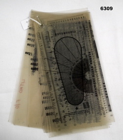
Equipment - Font -Type Style and Point Size Guide, Royal Australian Survey Corps, Circa 1991
Also referenced in the Collections Victoria Bendigo RSL item 6300 Lithographic Squadron Equipment Handbook 1991. Commonly called a type styles guide, used for the selection and editing of text styles and size in mapping.20 Sheets of 21 x 11 cm clear photographic film (connected in the Top left hand corner) depicting various Type Font Styles and Point Sizes including special characters. It also contains a digital Type gauge, a linometer and a screen angle Indicator. royal australian survey corps, rasvy, fortuna, army survey regiment, army svy regt, asr -
 Bendigo Military Museum
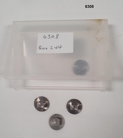
Equipment - Tri punched Film Registration System - stainless steel (studs), Ordinance Factory Bendigo, Circa 1960
These studs (pins) were used in the manual production of mapping to accurately register a number of sheets of film reproduction material together. A set of three studs were required. This simple but effective system allowed the reproduction material layers (repromat) to expand and contract with changes in temperature whilst maintaining the registration between sheets.Precision engineered stainless steel studs (pins) Set of three required for operation, includes a spare stud all stored in a plastic container. These studs were also produced as a low profile version for use in large format photographic vacuum contact frames so that they would not break the glass.royal australian survey corps, rasvy, fortuna, army survey regiment, army svy regt, asr -
 Bendigo Military Museum
Photograph - Typesetting Equipment and Personnel, Army Survey Regiment, Fortuna, Bendigo, c1968 to 1979
This is a set of nine photographs of cartographic typesetting equipment and personnel in Cartographic Squadron at the Army Survey Regiment, Fortuna, Bendigo circa 1968 to 1979. The rooms on the top floor of Fortuna Villa where the photos were taken were formally the nursery and boys bedrooms during the Lansell family’s occupation of the building. The Fotosetter type setting machine replaced the letterpress method of type production in 1956. Its operator entered the text using a type order provided by cartographic draughtsmen/ draughtswomen. The type was output on a film positive, which was contacted onto strip film. The text was cut out by cartographic draughtsmen/ draughtswomen and affixed onto type sheets using bees wax. Cartographic Squadron’s CPL Arty Lane specialised in the operation of the Fotosetter type setting machine for many years, as shown in photos .3P and .4P. For more information on the Fotosetter, see page 71 of Valerie Lovejoy’s book 'Mapmakers of Fortuna – A history of the Army Survey Regiment’ ISBN: 0-646-42120-4. The computer based Editwriter Model 7500 typesetting system was introduced in 1975 as a replacement to the aging Fotosetter. It was operated by a specialised technician, who generated a large variety of map type styles and sizes quickly and reliably, as well as text panels. Output on Copy proof adhesive backed stripping type film replaced messy wax and spray adhesives in 1978. The Editwriter capability supported all RASvy units and its contractor type setting requirements. SGT Jim McDonald operated the Editwriter for a couple of years in the late 1970’s. He is seen in photos .7P and .8P. reading off a type order and entering text into the computer. See item 6181.23P, photo .1P for a reduced scale photo of SGT Jim McDonald undertaking this task. Also see item 6123.12P photos .1P and .2P featuring CPL Paul Richards, who was another technician that operated the Editwriter for several years in the 1980s. The Editwriter was also operated by SSGT Pat Lumsden, as featured in photo .9P taken in 1979. The Monotype Photolettering Machine seen in photos .5P and .6P is understood to be in service for a shorter period, as it was not as productive compared to the Fotosetter and Editwriter. This is a set of nine photographs of cartographic typesetting equipment at the Army Survey Regiment, Fortuna, Bendigo, c1968 to c1979. Black and white photos are on photographic paper and scanned at 300 dpi. .1) - Photo, black & white, c1960s, Fotosetter type setting machine, unidentified technician. .2) - Photo, black & white, c1960s, Fotosetter type setting machine. .3) to .4) - Photo, black & white, c1968, Fotosetter type setting machine, CPL Arty Lane. .5) to .6) - Photo, black & white, c1970s, Monotype Photolettering Machine, unidentified technician. .7) to .8) - Photo, black & white, c1979, Typesetting machine, ‘Editwriter’ Model 7500, SGT Jim McDonald. .9) - Photo, black & white, 1979, Typesetting machine, ‘Editwriter’ Model 7500, SSGT Pat Lumsden.Personnel and equipment are identified in photos .1P to .3P. on a card. A description is provided: ‘Fotosetter: This model was used from 1956 to 1974. Where photograph was taken: Army Survey Regiment. Person in Photograph: Arty Lane. Approx date photograph taken: 1968. Any Misc Information: All type on maps was set on this machine. The operator of the machine (Ex SGT Lane) joined the Army in 1956 and was discharged in 1977. Also with Survey from 1942 to 1946. Information given by: Arty Lane’. Photo .9P is dated 1979 on the back.’royal australian survey corps, rasvy, army survey regiment, army svy regt, fortuna, asr, carto -
 Bendigo Military Museum
Photograph - Photogrammetric Equipment – Army Survey Regiment, Fortuna, Bendigo, c1960s to c1980s
This is a set of eight photographs of technicians operating photogrammetric equipment in Air Survey Squadron, Army Survey Regiment, Fortuna, Bendigo. c1960s to c1980s. The Wild A9 Stereocomparator and Wild B9 stereo plotter were introduced in 1962. The Wild B8 stereo plotter was introduced in 1966. Technicians used the Wild A9 Stereocomparator to accurately measure between pass, tie, and survey control points on aerial photographs. The Wild B9 and B8s were used for plotting topographic detail and contours. These analogue machines were manually controlled by adjusting the control knobs for the orientation of the 3D image. The B9s used a four and a half square, and the B8s used a nine-inch square photo image on a film or glass diapositive which allowed highly accurate extraction of map features. At first, plotting with B8 and B9 stereo plotters was undertaken at the aerial photography scale of 1:80,000 in pencil onto a controlled plotting sheet. Sheets were then inked up and reduced photographically to the 1: 100,000 publication scale for scribe impression production. In the early days topographic detail and contours were plotted with a pencil or ink pen mounted at the far end of the pantograph arm. The plotting procedure was upgraded to direct plotting in ink with photographic reduction to publication scale. In 1975 four B8s were upgraded with tri-axis locaters as part of the Input Sub-system to enable digital extraction to AUTOMAP 1’s topographic database. When AUTOMAP 2 was introduced in 1982 these B8s were upgraded, and additional machines added to expand the Army Survey Regiment’s digital capture capability. This is a set of eight photographs of technicians operating photogrammetric equipment in Air Survey Squadron, Army Survey Regiment, Fortuna, Bendigo. c1960s to c1980s. Black and white and colour photos are on photographic paper and scanned at 300 dpi. .1) - Photo, black & white, c1965. Unidentified technician operating a Wild A9 Stereocomparator. .2) - Photo, black & white, c1965. Unidentified technician operating a Wild B9 stereo plotter. .3) - Photo, black & white, c1967. L to R: Unidentified technician, SPR Ken Jeffery operating a Wild B9 stereo plotter. .4) - Photo, colour, c1974. Unidentified technician, operating a Wild B8 stereo plotter. .5) - Photo, black & white, c1974. Unidentified technician operating a Wild B8 stereo plotter. .6) to .7) - Photo, black & white, c1979. Unidentified technicians operating a Wild B8 stereo plotter. .8) - Photo, black & white, c1985. Unidentified technician in AUTOMAP 2 operating a Wild B8 stereo plotter..1P, .2P, .4P, .5P, .7P – no annotations. .3P – annotated ‘Standing - , Seated SPR Ken Jefferies (sic). .6P – annotated with date ‘1979’ .8P – annotated ‘AUTOMAP 2’royal australian survey corps, rasvy, army survey regiment, army svy regt, fortuna, asr, air survey, photogrammetry -
 Bendigo Military Museum
Photograph - Stereoscopic Equipment – Army Survey Regiment, Fortuna, Bendigo
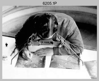
This is a set of six photographs of stereoscopic equipment and personnel at the Army Survey Regiment, Fortuna, Bendigo, c1950s to c1960s. The stereoscopes shown in photos .1P and .2P were used to stereoscopically view and interpret features in overlapping aerial photographs. The stereoscopic plotters shown in photos .3P and .4P were used to stereoscopically plot topographic detail from overlapping aerial photographs using a pantograph arm with pencil onto a controlled plotting sheet. The Ryker Model PL-3 Wernstedt-Mahan type stereoscopic plotter shown in photos .5P and .6P was used for precision contouring, planimetry and profiling. It was a comparatively simple stereoscopic mapping instrument designed to use ordinary contact prints of aerial photographs. It provides for plotting on a constant scale and approximate tilt correction but does not provide refinements such as correction for lens distortion. The plotter in Photo .6P does not have its pantograph arm attached. These plotters pre-date the Wild B9 and B8 stereo plotters introduced in the 1960s.This is a set of six photographs of stereoscopic equipment and personnel at the Army Survey Regiment, Fortuna, Bendigo, c1950s to c1960s. Black and white photos are on photographic paper and were scanned at 300 dpi. .1) - Photo, black & white, c1950s to c1960s, Universal Stereoscope, unidentified technician. .2) - Photo, black & white, c1950s to c1960s, Old Delft Scanning Stereoscopes, unidentified technicians. .3) - Photo, black & white, c1950s to c1960s, Unidentified stereoscopic plotters and technicians. .4) - Photo, black & white, c1950s to c1960s, Unidentified stereoscopic plotter, CPL Bill Shapcott. .5) and .6) - Photo, black & white, c1950s to c1960s, Ryker Model PL-3 stereoscopic plotter.Photo .4P is annotated on back - ‘Bill Shapcott (CPL)’royal australian survey corps, army svy regt, rasvy, army survey regiment, fortuna, asr, air survey, photogrammetry -
 Bendigo Military Museum
Photograph - Co-ordinatorgraph Map Grid Production, Army Survey Regiment, Fortuna Bendigo, c1960s to 1970s
This is a set of seven photographs of map grid production using co-ordinatorgraphs at the Army Survey Regiment, Fortuna Bendigo. c1960s to 1970s. The Aristo Co-ordinatorgraph introduced in 1962 was a large heavy steel framed light table with a scribing head that moved in a XY direction using a vernier calibrated measuring scale to 0.001 of an inch. Whilst hand operated it was much quicker and accurate than manual grid and graticule calculation, plotting and scribing. Mapping PNG presented the Regiment with many challenges. WO1 Farrington and CPL John Dean developed computer software for the digitally controlled co-ordinatorgraph, the Calcomp 718 Flatbed Plotter. Much time was saved by automatically plotted cartographic grids and graticules, and automatically draw base compilation sheets complete with aerial triangulated stereo model control. This could be used for a number of maps and was the first step towards map automation. The history of co-ordinatorgraphs is covered in more detail with additional historic photographs, in pages 50 to 51 and page 88 of Valerie Lovejoy’s book 'Mapmakers of Fortuna – A history of the Army Survey Regiment’ ISBN: 0-646-42120-4. SGT Bill Boyd appearing in photo .1P reach the rank of WO1 and for 11 years was the technical warrant officer at the Detachment Army Survey Regiment located at Bonegilla, Victoria. He was awarded the OAM, the Order of Australia Medal for the development of the Flexiflow quality control system. This system comprised a series of job plans and charts linked to a task allocation to resource magnetic planning board. Using critical path analysis and task prioritisation, complex job planning was efficiently scheduled, and re-prioritisations readily made. Reproduction requirements were effectively coordinated by way of weekly courier to the Army Survey Regiment. Supervisors and technicians fully embraced the system as they could understand their role, others around them and the positive production achievements. Bendigo. See page 178 of Valerie Lovejoy’s book for more information on WO1 Boyd’s contribution to RA Svy.This is a set of seven photographs of map grid production using co-ordinatorgraphs at the Army Survey Regiment, Fortuna Bendigo. c1960s to 1970s. The photographs were printed on photographic paper and are part of the Army Survey Regiment’s Collection. The photographs were scanned at 300 dpi. .1) - Photo, black & white, c1960s, L to R: SGT Bill Boyd demonstrating Aristo Co-ordinatorgraph equipment to unidentified technicians (x3) .2) - Photo, black & white, c1960s, Aristo Co-ordinatorgraph equipment. .3) - Photo, black & white, c1960s, unidentified technician operating Aristo Co-ordinatorgraph equipment. .4) - Photo, black & white, c1960s, L to R: PTE Desi Asaris and CPL Kalen Sargent operating Aristo Co-ordinatorgraph equipment. .5) - Photo, black & white, Photo, black & white, c1970s, John Bloor operating Calcomp co-ordinatorgraph equipment. .6) - Photo, black & white, Photo, black & white, c1970s, unidentified technician operating Calcomp co-ordinatorgraph equipment. .7) - Photo, black & white, Photo, black & white, c1970s, L to R: SGT Andy Covington and SGT John Waight operating Calcomp co-ordinatorgraph equipment..7P annotated on back ‘Covington & Waight’.royal australian survey corps, rasvy, army survey regiment, army svy regt, fortuna, asr, carto, air survey -
 Bendigo Military Museum
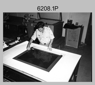
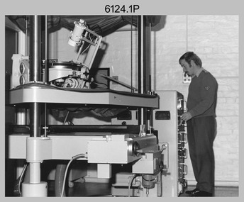
Photograph - Photo Troop Equipment and Personnel, Lithographic Squadron, Army Survey Regiment, Fortuna, Bendigo, 1960s and 1970s
This collection of 14 photos were taken at Lithographic Squadron, Army Survey Regiment, Fortuna, Bendigo probably in the 1960s and 1970s. The main tasks undertaken by technicians in Photo Troop were most likely enlargements, reductions and duplication of map reproduction material, and processing of aerial photography. The equipment operated by the technicians is the KLIMCH camera. The main tasks undertaken by the technicians were most likely enlargements and reductions of map reproduction material. The KLIMSCH Commodore camera was introduced in 1953 and was the largest in the Southern Hemisphere. It was replaced with a new model of the same size in 1979. The new model with its computer-based interface provided productivity gains with improved speed and its consistent results led to less wastage in time and materials. See items 6057.8P, 6056.11P and 6058.8P for more information and photos on Photo Troop equipment and personnel. There is more information on the KLIMSCH Commodore camera, on pages 70 and 120 of Valerie Lovejoy’s book 'Mapmakers of Fortuna – A history of the Army Survey Regiment’ ISBN: 0-646-42120-4. This collection of 14 photos were taken in Photo Troop, Lithographic Squadron, Army Survey Regiment, Fortuna, Bendigo probably in the 1960s and 1970s. The photographs were printed on photographic paper and are part of the Army Survey Regiment’s Collection. The photographs were scanned at 300 dpi. .1) - Photo, black & white, 1960s, KLIMSCH Commodore camera, unidentified technicians. .2) - Photo, black & white, 1960s, KLIMSCH Commodore camera, unidentified technician. .3) - Photo, black & white, 1960s, KLIMSCH Commodore camera. .4) - Photo, black & white, 1960s, KLIMSCH Commodore camera, unidentified technician. .5) - Photo, black & white, 1960s, KLIMSCH Commodore camera. .6) - Photo, black & white, 1960s, KLIMSCH Commodore camera, unidentified technicians. .7) - Photo, colour, 1970s, KLIMSCH Commodore camera, unidentified technicians. .8) - Photo, black & white, 1970s, WILD U4A Diapositive Camera, SPR Garry Hudson. .9) - Photo, black & white, 1970s, Photographic camera enlarger, SPR Garry Hudson. .10) - Photo, black & white, 1970s, Photographic camera enlarger, Phil Beaty. .11) - Photo, black & white, 1979, Film developer, SGT Garren Hill. .12) - Photo, black & white, 1970s, Film contact frame. .13) - Photo, black & white, 1970s, LogEtronics Contact Printer. .14) - Photo, black & white, 1970s, Tri-stud registered map separations with composite black negative on top.No personnel are identified. .11P annotated ‘1979’. .13P and .14P annotated ‘orthophoto’royal australian survey corps, rasvy, army survey regiment, army svy regt, fortuna, asr, litho -
 Bendigo Military Museum
Photograph - Print Troop Equipment and Personnel, Lithographic Squadron – Army Survey Regiment, Fortuna, Bendigo, c1970s
This collection of 17 photos was most likely taken in Lithographic Squadron, Army Survey Regiment, Fortuna, Bendigo, c1970s. Although these photos are not annotated most personnel are positively identified. Some photos are cropped enlargements of previous photos. See item 6060.8P for more information and photos of platemaking. There is more information on the Ultra-MAN-III, Komoni and Planeta Printing Presses on pages 71 and 120 of Valerie Lovejoy’s book 'Mapmakers of Fortuna – A history of the Army Survey Regiment’ ISBN: 0-646-42120-4. For additional photos, refer to item 6062.4P for the Heidelberg press, item 6063.5P for the Komori press, item 6064.9P for the Planeta press and item 6065.10P for Ultra-MAN-III presses. In photos .11P to .14P the technician is applying a UV-sensitive pigmented dye emulating one of the map print colours to a white opaque polyester sheet mounted on a rotating table in a whirler. .12P and .14P are enlargements of previous photos. See item 6059.4P for more information and photos on the map proof making process. The Krause Wohlenberg operated by George Austen in photo .17P was a heavy-duty guillotine to trim bulk printed map stock in the c1970s and c1980s. See item 6069.6P for more information and photos of guillotine equipment.This is a set of 17 photographs of Print Troop personnel and equipment from Lithographic Squadron at the Army Survey Regiment, Fortuna, Bendigo, c1970s. The photographs were printed on photographic paper and are part of the Army Survey Regiment’s Collection. The photographs were scanned at 300 dpi. .1) - Photo, black & white, c1970s, Preparing printing plate, SGT Alvan Howard. .2) to.3) - Photo, black & white, c1970s, Preparing printing plate, unidentified technician. .4) - Photo, black & white, 1979, Planeta Polygraph Printing Press., L to R: SPR Peter Breukel, CPL Lance Strudwick. .5) - Photo, black & white, c1970s, Ultra-MAN-III Printing Press. .6) and .7) - Photo, black & white, c1970s, Ultra-MAN-III Printing Press, unidentified technician. .8) - Photo, black & white, c1970s, Newkoni Komori Printing Press, unidentified technician. .9) - Photo, black & white, c1970s, Original Heidelberg Printing Press, unidentified technician. .10) - Photo, black & white, c1970s, MANN flatbed proof press, unidentified technician. .11) to .14) - Photo, black & white, c1970s, applying dye to a whirl-on proof, unidentified technician. .15) and .16) - Photo, black & white, c1970s, applying diazo coat to a scribe sheet, CPL Colin Hardisty. .17) - Photo, black & white, c1970s, Krause Wohlenberg heavy-duty paper guillotine, George Austen.No personnel are annotated. .2P annotated ‘completed development on a negative working plate.’ .3P annotated ‘a wipe-on plate.’ .4P annotated ‘1979’. .12P annotated ‘Re-coating a proof with the next wanted colour on the vertical whirler.’ .13P annotated ‘has hardened (retained) area required. Done on a vertical whirler.’ .15P and .16P annotated ‘Preparing a sheet of scribe material with a Diazo (light sensitive) coating.’royal australian survey corps, rasvy, army survey regiment, army svy regt, fortuna, printing, litho -
 Bendigo Military Museum
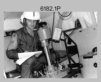
Photograph - Aerotriangulation Production – Army Survey Regiment, Fortuna, Bendigo, c1993
This is a collection of eight photographs of Air Survey Squadron personnel operating aerotriangulation equipment at the Army Survey Regiment at Fortuna, Bendigo, c1993. PUG4 devices were used by technicians to stereoscopically view the photography containing the survey control points and the mapping aerial photography. The Control points were transferred from the control photography to the mapping diapositives of aerial photography by drilling their locations into the photographic emulsion. The Zeiss (Jena) Stecometer analytic stereocomparator for air photography shown in photo .1P was introduced at Air Survey Squadron in 1963. Wild PUG4 point transfer devices shown in photos .2P to .4P were introduced in c1968 superseding the PUG2 devices. See item 6195.19P for more photos and descriptions of Air Survey Squadron personnel and aerotriangulation equipment.This is a set of eight photographs of Air Survey Squadron personnel operating aerotriangulation equipment at the Army Survey Regiment at Fortuna, Bendigo, c1993. The photographs were on 35mm negative film and were scanned at 96 dpi. They are part of the Army Survey Regiment’s Collection. .1) - Photo, black & white, c1993, Zeiss (Jena) Stecometer, SPR Kim Baker. .2) - Photo, black & white, c1993, Wild PUG4 point transfer device, CPL Paul Bouton. .3) to .4) - Photo, black & white, c1993, Wild PUG4 point transfer device, L to R: CPL Darren Scott, CPL Paul Bouton. .5) to .6P) - Photo, black & white, c1993, CPL Doug Willis. .7) - Photo, black & white, c1993, WO2 Noel ‘Macca’ McNamara. .8) - Photo, black & white, c1993, SGT Barry Miller..1P to .8P - There are no annotations.royal australian survey corps, rasvy, army survey regiment, army svy regt, fortuna, asr, aerotrig -
 Federation University Historical Collection
Equipment - Plate Dryer, Wooden photographic plate dryer
... photographic plate dryer Equipment Plate Dryer ...Used at Ballarat Technical Art School which is a predecessor of Federation University.Wooden rack with carved slots for placing photographic plates for drying 1/3 in lead pencil, plate drying rack, wooden rack, ballarat technical art school, plate drying -
Federation University Historical Collection
Book, Norton Alundum Refractories Catalogue
Small booklet with brown cover. Includes photographic illustrations. non-fictionrefractories, ceramics, crucibles, equipment, scientific equipment -
 Bendigo Military Museum
photograph - Aerotriangulation Production – Army Survey Regiment, Fortuna, Bendigo, c1980
This collection of five photos was most likely taken in 1980. Wild PUG4 point transfer devices were used by technicians in Air Survey Squadron to stereoscopically view the photography containing the survey control points and the mapping aerial photography. The Control points were transferred from the control photography to the mapping diapositives of aerial photography by drilling their locations into the photographic emulsion. The Zeiss (Jena) Stecometer analytic stereocomparator for air photography was introduced at Air Survey Squadron in 1963. Aerotriangulation production was expedited using computers for analytical photogrammetric processes. The technician accurately measured between pass, tie, and survey control points on aerial photographs.Air Survey Squadron Aerotriangulation Section - Army Survey Regiment, Bendigo. c1980. This is a set of five photographs of Air Survey Squadron personnel operating aerotriangulation equipment at the Army Survey Regiment at Fortuna, Bendigo, c1980. Photographs .1P to .4P are on 35mm negative film and were scanned at 96 dpi. Black and white photo .5P is on photographic paper and was scanned at 300 dpi. They are part of the Army Survey Regiment’s Collection. .1) - Photo, black & white, c1980, Wild PUG4 point transfer device, unidentified technician. .2) - Photo, black & white, c1980, Wild PUG4 point transfer device, unidentified technician. .3) - Photo, black & white, c1980, Wild PUG4 point transfer device, unidentified technician. .4) - Photo, black & white, c1980, Zeiss (Jena) Stecometer, unidentified technician. .5) - Photo, black & white, c1980, Zeiss (Jena) Stecometer..1P to .5P No personnel are identified.royal australian survey corps, rasvy, army survey regiment, army svy regt, fortuna, asr, air survey, aerotrig -
 Bendigo Military Museum
photograph - Orthorectification Equipment - Army Survey Regiment, Fortuna, Bendigo, c1975
Orthophoto mapping provided the Survey Corps with the capability to produce map products quickly in the event of a crisis. These are four photographs of equipment used by the Army Survey Regiment to produce orthophotomaps. The Wild GZ1 orthophoto projector was introduced in 1973 and was the first equipment used to orthorectify colour and monochrome film aerial photography. Height profiles were originally produced on a PEB8 Stereo profiler and later were software generated. Photos of the PEB8 are available in Victorian Collections item 6222.17P, photos .5P and .6P. In the same era the IBM 1130 computer; OMI/Nistri AP/C-3 analytical plotter with coordinatograph, OP/C orthophoto projector and Zeiss Planimat D2 stereoplotters were introduced. Orthorectification is the process of removing geometric distortions and scale errors/variations from images. Images have tilt and relief distortions that make it difficult to compare accurately a map and an image of the same geographic area. Once an image is orthorectified, features on the image are shown in their planimetric locations. These four photographs of orthorectification equipment were taken at the Army Survey Regiment at Fortuna, Bendigo, c1975. Photo .1P and .3P were printed on photographic paper and scanned at 300 dpi. Photos .2P, .4P and .5P were on 35mm negative film and scanned at 96 dpi. They are part of the Army Survey Regiment’s Collection. .1) - Photo, black & white, c1975, Wild GZ1 orthophoto projector operated by CPL Phil Boyle. .2) - Photo, black & white, c1975, Wild GZ1 orthophoto projector. .3) - Photo, black & white, c1975, Wild GZ1 orthophoto projector. .4) - Photo, black & white, c1978, Zeiss D2 Planimat Stereoplotter. .5) - Photo, black & white, c1978, Zeiss D2 Planimat Stereoplotter..1P to .5P No annotations.royal australian survey corps, rasvy, army survey regiment, army svy regt, fortuna, asr -
 Bendigo Military Museum
Photograph - Royal Australian Survey Corps Aerial Surveys, c1980
This is a set of nine photographs of technicians from the Royal Australian Survey Corps operating aerial surveys equipment c1980s. In photo .1P, CPL Steve Gloster was operating a RC10 air survey camera mounted in an Australian Army Pilatus Porter aircraft. The Wild RC10 super wide-angle air survey cameras were first introduced in 1971, were equipped with virtual distortion free lenses for supplementary, spot and special photography. In photo .2P, Roger Rees was operating Air Profile Recorder (APR) equipment. it was possibly taken during OP NERVOSE 84, sometime between June – August 1984 when based in Ngukurr, Northern Territory. The APR was operated at this time in unison with an RC10 camera. In 1963 the Royal Australian Survey Corps introduced the radar airborne profile recorder (Canadian Applied Research Ltd, Mark V, Airborne Profiler Recorder) was introduced for 1:100,000 mapping to replace terrain heighting by aneroid barometry. Later in 1974-1975, the Australian developed WREMAPS II airborne laser terrain profile recorder was introduced. In photo .3P, Neil Jones appears at the door of Airsearch Beechcraft Queen Air aircraft, Registration / Serial VH-MWX. This aircraft was typically used by RA Svy on air survey operations flying mission with Aerodist, APR and RC10 camera equipment. The Australian Army’s Pilatus Porter (short take-off and landing turbo propeller) was also equipped with a Wild RC10 aerial mapping camera for identification photography. The Pilatus Porter was also used on RA Svy’s map field checking operations. Photo .9P was taken at a survey station at an unknown location. In this photo an Australian Army Kiowa Light Observation Helicopter (LOH) is supporting a field survey party undertaking Magnavox AN/PRR-14 portable Doppler satellite observations. The satellite receiver’s antenna is plumbed over the survey ground mark surrounded by white plastic panels. The panels were used to identify the survey station on aerial photography. Introduced in 1974–1975, the Magnavox AN/PRR-14 portable Doppler satellite (US Navy Navigation Satellite System – TRANSIT) receivers and computing system provided independent three-dimensional point positions anywhere in the world, anytime, in any weather accurate to about 1.5metres with precise satellite ephemerides. The Bell OH-58 Kiowa LOH was a family of military helicopters used for observation, utility, and direct fire support. It was identified by RA Svy in the mid-1970s that considerable time was lost in replacing unserviceable remote equipment by road. Therefore Aerodist operations (pre-dating satellite receiver operations) were fully supported by Army’s Kiowa LOH aircraft. This is a set of nine photographs of technicians from the Royal Australian Survey Corps operating aerial surveys equipment c1980s. .1P to .3P, .5P to .9P - Colour and black and white photos on photographic paper and scanned at 300 dpi. .4P - Colour photo on 35mm slide film and scanned at 96 dpi. .1) & .2) - Photo, black & white, c1980s, CPL Steve Gloster operating an RC10 air camera. .3) - Photo, colour, 1984, Roger Rees operating Air Profile Recorder (APR) equipment. .4) - Photo, colour, c1980s, Neil Jones at the door of an Airsearch Beechcraft Queen Air aircraft, typically used by RA Svy on air survey operations. .5) - Photo, colour, c1980s. A Beechcraft King Air aircraft, also used by RA Svy on air survey operations. .6) - Photo, colour, c1980s. An Australian Army Pilatus Porter, used by RA Svy on air survey and map field checking operations. SGT Peter Mustart is possibly in the foreground. .7) to .8) - Photo, colour, c1980s. An Australian Army Pilatus Porter and unidentified personnel, used by RA Svy on air survey and map field checking operations. .9) - Photo, colour, c1980s. An Australian Army Kiowa helicopter supporting a field survey party undertaking Magnavox AN/PRR-14 portable Doppler satellite observations. There are biro marks on photos .4P to .9Proyal australian survey corps, rasvy, army survey regiment, asr, fortuna, aerial surveys -
 Bendigo Military Museum
Photograph - Capturing Topographic Features with a Wild B8 – Army Survey Regiment, Fortuna, Bendigo, c1980
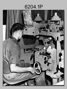
These four photographs of SPR Santina (Argetto) Straube capturing topographic features – plotting with a Wild B8 stereo plotter were most likely taken in c1980. Introduced in 1966, the Wild B8 stereo plotter was used for plotting topographic detail and contours. These analogue machines were manually controlled by adjusting the control knobs for the orientation of the 3D image. The B8s used a nine-inch square photo image on a film or glass diapositive which allowed highly accurate extraction of map features. At first, plotting by B8 and B9 equipment was undertaken at the aerial photography scale of 1:80,000 in pencil onto a controlled plotting sheet. Sheets were then inked up and reduced photographically to the 1: 100,000 publication scale for scribe impression production. In these photos SPR Santina (Argetto) Straube was plotting with a pencil or ink pen mounted at the far end of the pantograph arm. The plotting procedure was upgraded to direct plotting in ink with photographic reduction to publication scale. In 1975 four B8s were upgraded with tri-axis locaters as part of the Input Sub-system to enable digital extraction to AUTOMAP 1’s topographic database. When AUTOMAP 2 was introduced in 1982 these B8s were upgraded, and additional machines added to expand the Army Survey Regiment’s digital capture capability. This is a set of four photographs of a technician capturing topographic Features with a Wild B8 stereo plotter in Air Survey Squadron – Army Survey Regiment, Fortuna, Bendigo. 1980. The photographs were on 35mm negative film and were scanned at 96 dpi. They are part of the Army Survey Regiment’s Collection. .1) to .4) Photo, black & white, c1980. SPR Santina (Argetto) Straube operating a Wild B8 stereo plotter..1P to .4P – no annotations.royal australian survey corps, rasvy, army survey regiment, army svy regt, fortuna, asr, air survey, photogrammetry -
 Bendigo Military Museum
Photograph - Aerotriangulation Production – Army Survey Regiment, Fortuna, Bendigo, c1979
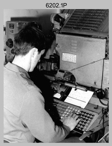
This collection of 19 photos was most likely taken in 1979 in Air Survey Squadron. The PDP 11/70 minicomputer shown photos .2P to .3P was the operating system introduced in 1977 as the mainframe system for the control of the APC4, aerial triangulation block adjustments, SORA OP Analytical Orthophoto control, APR Analytical Terrain Profile Recorder computation, graphics, and general computing. The Zeiss (Jena) Stecometer analytic stereocomparator for air photography shown in photos .5P to .9P was introduced at Air Survey Squadron in 1963. Aerotriangulation production was expedited using computers for analytical photogrammetric processes. The technician accurately measured between pass, tie, and survey control points on aerial photographs. The OMI/Nistri AP/C-3 analytical plotter shown in photos .10P and .11P was introduced in 1972–1973. Photo .11P shows a coordinatorgraph attached to the AP/C-3. The Zeiss D2 Planimat Stereoplotter shown in photo .12P was used for analytical orthophoto control. Wild PUG4 point transfer devices shown in photos .17P to .19P were introduced in c1968 superseding the PUG2 devices. PUG4 devices were used by technicians to stereoscopically view the photography containing the survey control points and the mapping aerial photography. The Control points were transferred from the control photography to the mapping diapositives of aerial photography by drilling their locations into the photographic emulsion.This is a set of 19 photographs of Air Survey Squadron personnel operating aerotriangulation equipment at the Army Survey Regiment at Fortuna, Bendigo, c1979. Black and white photos are on photographic paper and were scanned at 300 dpi. They are part of the Army Survey Regiment’s Collection. .1) - Photo, black & white, c1979, Aerotriangulation tasks, unidentified technicians. .2) to .3) - Photo, black & white, c1979, PDP-11 minicomputers tasks, unidentified technician. .4) - Photo, black & white, c1979, Aerotriangulation tasks, unidentified technician. .5) - Photo, colour, c1979, Zeiss (Jena) Stecometer, unidentified technician. .6) to.9) - Photo, black & white, c1979, Zeiss (Jena) Stecometer, unidentified technician. .10) - Photo, black & white, c1984, OMI/Nistri APC/3-1 analytical stereoplotter, SPR Kristin (Isaac) Skidmore. .11) - Photo, colour, c1979, OMI/Nistri APC/3-1 analytical stereoplotter, unidentified technician. .12) - Photo, colour, c1979, Zeiss D2 Planimat Stereoplotter, unidentified technician. .13) - Photo, black & white, c1979, Aerotriangulation tasks, unidentified technician. .14) - Photo, black & white, c1979, Aerotriangulation tasks, unidentified technician. .15) - Photo, black & white, c1979, Aerotriangulation tasks, CPL Ken Talbot-Smith .16) - Photo, black & white, c1979, Aerotriangulation tasks, SPR David Jobe. .17) - Photo, black & white, c1979, Wild PUG4 point transfer device, WO2 Brian Mead. .18) - Photo, black & white, c1979, Wild PUG4 point transfer device, CPL Andy Wilson. .19) - Photo, black & white, c1979, Wild PUG4 point transfer device, unidentified technician..5P is annotated ‘OMI-Nistri AP/C Analytical Plotter’ and ’Topo 36’. .12P is annotated ‘Zeiss Jena Stecometer Stereocomparator’ and ’Topo 35’. There are no annotations on the other photos.royal australian survey corps, rasvy, army survey regiment, army svy regt, fortuna, asr, aerotrig, air survey -
 Bendigo Military Museum
Photograph - Multiplex mechanical stereoplotting equipment, Army Survey Regiment, Fortuna Bendigo, c1950s
This is a set of five photographs of Multiplex mechanical stereoplotting equipment at the Army Survey Regiment, Fortuna Bendigo. c1950s. Multiplex equipment was imported from the UK in 1951 and introduced in the following year, to accelerate map production output covering CMF training areas at 1:25,000 map scale. Multiplex plotting was a productive advancement replacing the ‘Arundel’ method of graphical plotting planimetric detail that was expensive and slow, especially in timbered mountainous terrain. Air photos were made into small diapositives and mounted on racks in the exact position relative to when the aerial photos were taken. The technicians operated the Multiplex in a darkened room, with one photo projected with a green filter and the other through a red filter to form a 3D view of the overlapping photos. The 3D model projected onto a platen, which was a small platform that was raised up and down. The technician viewed the 3D image with special glasses fitted with red and green lenses. In the centre of the platen was a small pinhole that served as a floating mark, with a vertical pencil located exactly below the pinhole. This tracing table was moved to follow the topographic feature or contour line and draw it on the paper underneath. The technician raising or lowering the platform’s floating mark to match the height of the 3D terrain. It also replaced the slotted template method of mechanical adjustment of strips of aerial photography, however was restricted to each strip rather than between strips in the block. Although the Multiplex was phased out of production in 1968, it was used in the training of photogrammetry and aero-triangulation at the School of Military Survey located at Bonegilla, Victoria until the early 1990s. The history of the Multiplex is covered in more detail with additional historic photographs, in pages 50 to 51 of Valerie Lovejoy’s book 'Mapmakers of Fortuna – A history of the Army Survey Regiment’ ISBN: 0-646-42120-4.This is a set of five photographs of Multiplex mechanical stereoplotting equipment at the Army Survey Regiment, Fortuna, Bendigo. c1950s. The photographs were printed on photographic paper and are part of the Army Survey Regiment’s Collection. The photographs were scanned at 300 dpi. .1) - Photo, black & white, c1950s, unidentified personnel operating Multiplex equipment. .2) - Photo, black & white, c1950s, Multiplex equipment. .3) - Photo, black & white, c1950s, Multiplex components identified. .4) - Photo, black & white, c1950s, Multiplex optical components. .5) - Photo, black & white, c1950s. Unidentified technician laying down individual Multiplex plots..1P to .2P, .4P – No annotations. .3P annotations identifying Multiplex components on front of photo. .5P annotated on front ‘Lay down of individual Multiplex plots at 1/14000 to framework of master grid to form Composite Compilation Sheet – Material Duralex.’royal australian survey corps, rasvy, army survey regiment, army svy regt, fortuna, asr, photogrammetry -
 Bendigo Military Museum
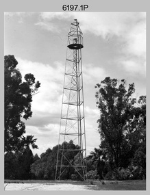
Photograph - Royal Australian Survey Corps Survey Observation Towers, c1950s
This is a set of seven photographs of Royal Australian Survey Corps surveyors setting up observation towers in the field and undertaking survey observations during mapping and geodetic control operations. c1950s. Survey observation towers were used mainly to take angular measurements in flat or heavily forested terrain, where height was necessary to achieve observer’s line-of-sight between field survey station. The Bilby Tower seen in photo .5P was erected to a height of 75 feet (23m) above ground level. The use of the Bilby Tower in Topographic Squadron’s field survey operations from 1955 to 1966 is described in page 54 of Valerie Lovejoy’s book 'Mapmakers of Fortuna – A history of the Army Survey Regiment’ ISBN: 0-646-42120-4. CAPT George Ricketts’ period of service was from 1942 to 1976 reaching the rank of LTCOL. It is noted in page 35 of Valerie Lovejoy’s book that then SGT Ricketts hand lettering skills came to the fore from his contribution to the draughting of one of the Japan’s Instruments of Surrender in 1945.This is a set of seven photographs of Royal Australian Survey Corps surveyors setting up observation towers in the field and undertaking survey observations during mapping and geodetic control operations. c1950s. The photographs were printed on photographic paper and are part of the Army Survey Regiment’s Collection. The photographs were scanned at 300 dpi. .1) - Photo, black & white, c1950s, ‘Bilby’ survey observation tower. .2) - Photo, black & white, c1950s, CAPT George Ricketts climbing ‘Bilby’ survey observation tower. .3) - Photo, black & white, c1950s, geodetic survey equipment on ‘Bilby’ survey observation tower. .4) - Photo, black & white, c1950s, two unidentified field surveyors on ‘Bilby’ survey observation tower. .5) - Photo, black & white, c1950s, two unidentified field surveyors, with CAPT Ricketts climbing ‘Bilby’ survey observation tower. .6) - Photo, black & white, c1950s, two unidentified field surveyors undertaking observations on survey observation tower. .7) - Photo, black & white, c1950, two unidentified field surveyors erecting or dismantling a survey observation tower..1P with paper tag annotated ‘Bilby Tower’ .4P on back – ‘Bilby Tower’. .5P on back – ‘Survey Observing Tower. Observing tower used for angular measurement in flat country. 75’ high – CAPT Ricketts climbing. .6P, .7P on back. ‘1960s?’royal australian survey corps, rasvy, army survey regiment, army svy regt, fortuna, asr, surveying -
 Bendigo Military Museum
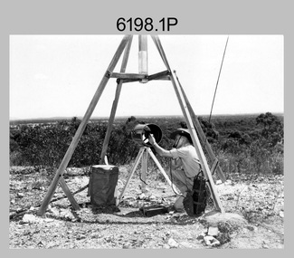
Photograph - Royal Australian Survey Corps Electronic Distance Measuring Equipment Demonstration, c1960s
This is a set of five photographs of CAPT James ‘Jim’ Leslie Stedman in the field demonstrating the setup of prisms used as electric distance measurement (EDM) receiver reflectors for tellurometer equipment and the sighting of a large surveyor’s light. This equipment was deployed in establishing mapping and geodetic control operations. The photos were most likely taken in the late 1950s or early 1960s. The tellurometers of this era were man-portable systems that improved geodetic survey efficiencies for rapid network extension and densification replacing triangulation with EDM and theodolite traverse sometimes using Bilby Towers to extend line lengths. Jim Stedman later reached the rank of Colonel, was Director of Military Survey from 1975 to 1978 and was appointed as Colonel Commandant (honorary appointment, Retd) of the Royal Australian Survey Corps from 1978 to 1983. Jim Stedman is demonstrating EDM equipment. See item 6180.16P, photos .14) to .16) for more information and photos of Jim Stedman’s EDM demonstration. This is a set of five photographs of a surveyor in the field demonstrating electric distance measurement (EDM) equipment. c1950s – 1960s. The photographs were printed on photographic paper and are part of the Army Survey Regiment’s Collection. The photographs were scanned at 300 dpi. .1) to .2) - Photo, black & white, c1960s, CAPT Jim Stedman demonstrating the sighting of a large surveyor’s light. .3) to .5) – Photo, black & white, c1960s, CAPT Jim Stedman demonstrating EDM prism equipment. .1P to .5P on back – CAPT Stedman EDM Eqpt.royal australian survey corps, rasvy, army survey regiment, army svy regt, fortuna, asr, surveying -
 Bendigo Military Museum
Photograph - Army Survey Regiment Map Production Equipment, c1980s, c1990s
Photos .1P, .2P, and.4P were most likely taken in the 1980s and photos .3P, .5P to .7P in the c1990s at the Army Survey Regiment, Fortuna, Bendigo. Despite lacking annotation on exact dates, locations and personnel, they are positively identified. CPL Ian Nelson in photo .1P is operating a Wild Pug 4 point transfer device in Air Survey Squadron c1980s. Control points were transferred onto the mapping diapositives of aerial photography by drilling their locations into the photographic emulsion. SPR Viv (Hawkins) Doherty in photo .2P, SPR Jeanette Drury-Lane in photo .5P and SGT Sandy Craig are operating a Wild B8 Stereoplotter coupled to a digital workstation in Air Survey Squadron c1994. Topographic features were extracted with the B8 in 3D and feature coded with attributes, using keyboard, menu, keypad and voice inputs to the computer. The features were stored in the AUTOMAP 2 digital database for subsequent cartographic production and printing. CPL Mick Ellis in photo .3P is operating the Optronix 4040 Scanner/Film Writer in Lithographic Squadron c1990s. In scanning mode, compilation sheets were mounted on the drum and scanned. The resultant raster file was vectorized, feature coded with attributes and stored by cartographic technicians in the AUTOMAP 2 database. In film writing mode, digital cartographic files were output at very high resolution for each print colour on photosensitive film, for subsequent finalisation, platemaking and printing.This is a set of seven photographs of technicians operating map production equipment at the Army Survey Regiment, Bendigo. The photographs were printed on photographic paper and are part of the Army Survey Regiment’s Collection. The photographs were scanned at 300 dpi. .1) - Photo, colour, c1980s. CPL Ian Nelson operating a Wild Pug 4 point transfer device in Air Survey Squadron. .2) - Photo, colour, c1980s. Wild B8 Aviograph stereoplotter feature extraction, SPR Viv (Hawkins) Doherty in Air Survey Squadron. .3) - Photo, colour, c1990s. CPL Mick Ellis operating the Optronics 4040 Scanner in Lithographic Squadron. .4) - Photo, colour, c1984. AUTOMAP 2 Graphic Edit Workstation, SPR Craig Kellet in Cartographic Squadron. .5) - Photo, colour, c1994. Wild B8 Aviograph stereoplotter feature extraction, SPR Jeanette Drury-Lane in Air Survey Squadron. .6) - Photo, colour, c1994. AUTOMAP 2 Graphic Edit Workstation, L to R: unidentified, SPR Rachel (Stanford) Scott, CPL Chris Wynn in Cartographic Squadron. .7) - Photo, colour, c1994. Wild B8 Aviograph stereoplotter AUTOMAP 2 Graphic Edit Workstation, L to R: unidentified (x2), SGT Sandy Craig in Air Survey Squadron..1P – no annotations .2P – annotated “Stereoplotter Workstation. The operator has the use of keyboard, menu, keypad and voice for input to the computer. Feedback is given through voice and screen messages.” .3 to .7P – no annotationsroyal australian survey corps, rasvy, army survey regiment, army svy regt, fortuna, air survey, litho, aerotrig, automap 2 -
 Bendigo Military Museum
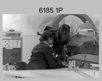
Photograph - Lithographic Squadron Personnel and Equipment, Army Survey Regiment, Fortuna, Bendigo, 1992
This collection of 34 photos of Lithographic Squadron personnel and equipment was taken in at the Army Survey Regiment, Fortuna, Bendigo, in 1992. The photos were mainly taken in the Camera, Contacting, Printing, BARCRO and Production Control work areas, as well as outside Fortuna’s buildings. Although these photos are not annotated most personnel are positively identified. This is a set of 34 photographs of Lithographic Squadron personnel and equipment at the Army Survey Regiment, Fortuna, Bendigo, 1992. Photographs .1P to .32P are on 35mm negative film and scanned at 96 dpi. Colour photos .33P and .34P are on photographic paper and scanned at 300 dpi. They are part of the Army Survey Regiment’s Collection. .1) - Photo, black & white, 1992, back row L to R: Andrew Arman, unidentified Mark McCulloch, Dale Hudson, front row L to R: Daryl South, unidentified (x2). Janet Murray, LT Dave Weston. .2) - Photo, black & white, 1992, back row L to R: unidentified, CPL Paul Baker, Shona Hastie, front row L to R: LT Craig Hersant, Darren Maher, Chad Hardwick, Rob Jones. .3) - Photo, black & white, 1992, WO2 Steve Egan. .4) - Photo, black & white, 1992, LT Craig Hersant. .5)- Photo, black & white, 1992, CPL Warren Shirley, Jeff Willey, Gary Kerr. .6) - Photo, black & white, 1992, L to R: CPL Penny Knott, Janet Murray, Shona Hastie. .7) - Photo, black & white, 1992, L to R: MAJ Terry Edwards, LT David Weston. .8) - Photo, black & white, 1992, Frank Lenane, WO1 Trevor Osborne. .9) - Photo, black & white, 1992, L to R: WO2 Rob Bogumil, WO2 Steve Egan. .10) - Photo, black & white, 1992, back row L to R: Terry Winzar, Roy Hicks Marty Stradbrook, Janet Murray, Nick Vanderzwan, Mark Bird, front row L to R: SGT Dale Hudson, SSGT Russ Mollenhauer, Ross Anza, SGT Kim Reynolds, SGT Stuart Ridge, WO2 Jeff Willey, Peter Hamilton, Garry Lord, Gavin McLean, unidentified. .11) - Photo, black & white, 1992, Janet Murray, Mick Muzeen. .12) and .13) - Photo, black & white, 1992, Janet Murray. .14) to.16) - Photo, black & white, 1992, SPR Scott Cameron, CPL Warren Shirley. .17) - Photo, black & white, 1992, L to R: SPR Shane Campbell, SGT Brian Paul. .18) - Photo, black & white, 1992, LCPL John Bragg. .19) - Photo, black & white, 1992, SPR Allison (Ottaway) Wooldrage. .20) - Photo, black & white, 1992, map inspection station, LT Colin Davidson. .21) - Photo, black & white, 1992, map inspection station. .22) - Photo, black & white, 1992, map inspection station, LT Colin Davidson. .23) and .24) - Photo, black & white, 1992, map inspection station, SPR Nicole Midgley. .25) - Photo, black & white, 1992, map inspection station. .26) - Photo, black & white, 1992, map inspection station, unidentified. .27) - Photo, black & white, 1992, CPL Penny Knott. .28) - Photo, black & white, 1992, CPL Ken Peters. .29) - Photo, black & white, 1992, WO2 Rob Bogumil. .30) - Photo, black & white, 1992, L to R: WO2 Peter Imeson, WO2 Rob Bogumil. .31) and .32) - Photo, black & white, 1992, L to R: SGT Brian Fauth. .33) - Photo, colour, 1992, Klimch Camera, CPL Damien Cole. .34) - Photo, colour, 1992, Speedmaster Printing Press, L to R: SGT Gary Kerr, unidentified, SGT Kim Reynolds, SPR Shane Campbell.No personnel are identified.royal australian survey corps, rasvy, army survey regiment, army svy regt, fortuna, asr, litho -
 Bendigo Military Museum
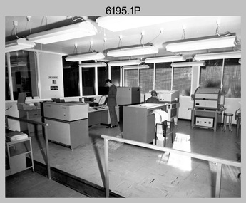
Photograph - Army Survey Regiment Personnel and Equipment, Fortuna, Bendigo, 1992
This collection of 15 photos of personnel and equipment was taken at the Army Survey Regiment, Fortuna, Bendigo, in 1992. The photos feature the inside Lithographic Squadron, external buildings, the transport compound, and the gardener’s end of the duty hut. Although these photos are not annotated most personnel are positively identified. Photos .14) to.15) feature Neil Morgan, who was a permanent ground maintenance employee.This is a set of 15 photographs of personnel and equipment at the Army Survey Regiment, Fortuna, Bendigo, 1992. The photographs are on 35mm negative film and were scanned at 96 dpi. They are part of the Army Survey Regiment’s Collection. .1) - Photo, black & white, 1992, outside Litho’s BARCRO work area (old entrance to Roman Bath) .2) - Photo, black & white, 1992, SPR Scott Cameron outside the Old OR’s Barracks. .3) - Photo, black & white, 1992, bank of the lake with Old & New OR’s Barracks. .4) - Photo, black & white, 1992, unidentified outside Q-Store buildings. .5)- Photo, black & white, 1992, records building under construction. .6) - Photo, black & white, 1992, ITEC type setter. .7) and .8) - Photo, black & white, 1992, ITEC type setter and IGX printer. .9) - Photo, black & white, 1992, IGX printer. .10) - Photo, black & white, 1992, Pakotone photographic processor. .11) - Photo, black & white, 1992, densitometer. .12) and .13) - Photo, black & white, 1992, unidentified RACT personnel in transport compound. .14) to.15) - Photo, black & white, 1992, Neil Morgan readying the ride-on lawn mower at rear end of Duty Hut. No personnel are identified.royal australian survey corps, rasvy, army survey regiment, army svy regt, fortuna, asr, litho -
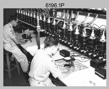
 Bendigo Military Museum
Photograph - Equipment and Personnel, Lithographic Squadron - Army Survey Regiment, Bendigo, c1975
This is a set of 21 photographs of Lithographic Squadron equipment and personnel as well equipment operated by Cartographic Squadron, Army Survey Regiment, Fortuna, Bendigo circa 1975. The photos were mainly taken in the Printing, Camera, proofing and external buildings. Cartographic Squadron’s CPL Arty Lane operated the Fotosetter type setting machine, as shown in photo .21P for many years in a room on the top floor of Fortuna Villa. There is more information on the Ultra-MAN-III Printing Presses, the KLIMSCH Commodore camera, Gavin Neilson and the Fotosetter type setting machine on pages 70-71, and the Newkoni Komori printing press on page 120 of Valerie Lovejoy’s book 'Mapmakers of Fortuna – A history of the Army Survey Regiment’ ISBN: 0-646-42120-4.This is a set of 21 photograph of Lithographic Squadron equipment and personnel, Army Survey Regiment at Fortuna, Bendigo, 1989. Black and white photographs .1P to .13P are on 35mm negative film and scanned at 96 dpi. Black and white photos .14P to .21P are on photographic paper and were scanned at 300 dpi. .1) - Photo, black & white, c1975, tri-linear film punch. .2) to .5) - Photo, black & white, c1975, Newkoni Komori printing press components. .6) - Photo, black & white, c1975, Newkoni Komori printing press components, Alex Cook. .7) - Photo, black & white, c1975, Newkoni Komori printing press components. .8) to .12) - Photo, black & white, c1975, northern exterior of print buildings. .13) - Photo, black & white, c1975, L to R: unidentified (x2), Jim Mulqueen, Ian ‘Lofty’ Turner. .14) - Photo, black & white, c1975, Log Electonics film processor. .15) - Photo, black & white, c1975, contact frame. .16) - Photo, black & white, c1975, film tri-punch stud registration table. .17) - Photo, black & white, c1975, Ultra-MAN-III Printing Presses. .18) to .19) - Photo, black & white, c1975, KLIMSCH Commodore camera, Gavin Neilson. .20) - Photo, black & white, c1975, map proof whirler. .21) - Photo, black & white, c1975, Fotosetter type setting machine.No personnel are identified. .14P, .16P to .19P and .20P to .21P are annotated with 5-digit numbers on top right corner of photo.royal australian survey corps, rasvy, army survey regiment, army svy regt, fortuna, asr, litho, carto -
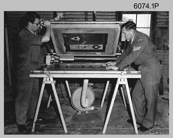 Bendigo Military Museum
Photograph - Lithographic Technicians Screen Printing at the Army Survey Regiment, c1970s
These two photographs were most likely taken in the 1970s at the Army Survey Regiment’s Drill Hall Golden Square, Bendigo. The photos are annotated with the name of the technicians written on the back. In these photos the technicians are performing screen printing tasks.This is a set of photographs of lithographic technicians using screen printing equipment at the Army Survey Regiment, Bendigo from c1960s to c1980s. The photographs were printed on photographic paper and are part of the Army Survey Regiment’s Collection. The photographs were scanned at 300 dpi. .1) - Photo, black & white, c1970s, L to R: Bruce Appleford, SGT Evan Giri, Lithographic Squadron .2) - Photo, black & white, c1970s, Ian ‘Lofty’ Turner, Lithographic Squadron.1 to .2 – personnel names (less rank) annotated on back. royal australian survey corps, rasvy, army survey regiment, army svy regt, fortuna, asr, litho, printing -
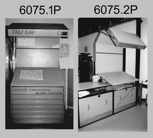 Bendigo Military Museum
Photograph - Equipment used in Map Production at the Army Survey Regiment, 1991
These nine photographs of technical equipment were provided to the Directorate of Survey as input to the 1990-1991 Annual Report. The equipment in Photos .1P and .2P were used to evaluate/validate colour values on printed maps. The equipment in Photo .3P is a daylight film processor. The Optronix 5040 Laser Scanner/Plotter was shown in Photos .4P to .6P. The Print Room’s Map Handling Station in photo .7P provided ergonomic benefits to the Printer Technician and improved despatching productivity. The Optical Disk Archive and Retrieval System (ODARS) equipment in .8P was optical "platter" disk technology for the secure and long term archive storage of large amounts of digital map data. Map data was transferred from large reels of magnetic tape. As most map type (letters and names) generation was done in Automap 2, The ITEK Typesetter shown in photo .9P was close to obsolete in 1991. At this time it was used to generate map type for other RASvy units, contractors and sections still performing manual map production at Army Svy Regt.This is a set of photographs of Army Survey Regiment technical equipment taken in 1991. The photographs were printed on photographic paper and are part of the Army Survey Regiment’s Collection. The photographs were scanned at 300 dpi. .1) - Photo, black & white, 1991, Colour Evaluation Workstation No 1, Lithographic Squadron .2) - Photo, black & white, 1991, Colour Evaluation Workstation No 2, Lithographic Squadron .3) - Photo, black & white, 1991, Daylight film processor, Lithographic Squadron, Daylight Working Contacting Frames in background. .4) - Photo, black & white, 1991, Optronix 5040 Laser Scanner/Plotter, Lithographic Squadron .5) - Photo, black & white, 1991, Optronix 5040 Laser Scanner/Plotter, Lithographic Squadron .6) - Photo, black & white, 1991, Optronix 5040 Laser Scanner/Plotter, Lithographic Squadron .7) - Photo, black & white, 1991, Map Handling Station, Lithographic Squadron .8) - Photo, black & white, 1991, Optical Disk Archive and Retrieval System (ODARS), Cartographic Squadron .10) - Photo, black & white, 1991, Optronix 5040 Laser Scanner/Plotter, Lithographic Squadron .9) - Photo, black & white, 1991, ITEK Typesetter, Cartographic Squadron.1P, .2P, .4P to .10P – equipment description annotated on back .3P - no annotation.royal australian survey corps, rasvy, army survey regiment, army svy regt, fortuna, asr, litho, automap -
 Bendigo Military Museum
Manual - Map Reproduction and Equipment Specification Handbook, Circa 1975
Manual used by Lithographic Technicians as a register of Map reproduction equipment. Possible uses include to identify and quantify available equipment as part of the stocktaking process.90 page technical manual/ handbook. Does not have a front cover. Contents page and pages within the document have black and white stock descriptions followed by photos of equipment. The manual is printed on photographic paper and is bounded by a black plastic spiral spline.royal australian survey corps, rasvy, fortuna, army survey regiment, army svy regt, asr -
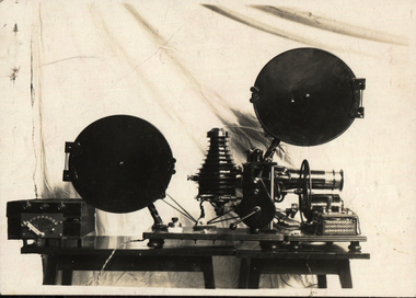 Federation University Historical Collection
Photograph - Black and White Photographs, Projection Equipment
... Images of movie projections equipment in an old... equipment in an old photographic envelope from Herschell's Melbourne ...Images of movie projections equipment in an old photographic envelope from Herschell's Melbournetheatre, movie, herschells, projections