Showing 489 items
matching planning scheme
-
 Eltham District Historical Society Inc
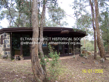
Photograph - Digital Photograph, Marguerite Marshall, Former office of Alistair Knox, King Street, Eltham, 16 January 2006
... , Nillumbik Planning Scheme. Published: Nillumbik Now..., Nillumbik Planning Scheme. Published: Nillumbik Now ...Situated in King Street, Eltham, Alistair Knox built his home and office in 1962-1963 with mud-bricks made from the local soil and recycled materials blending the house with bush around it. Knox popularised the Eltham earth building movement, begun by Montsalvat founder, Justus Jorgensen. Alistair Knox (1912-1986) was also an Eltham Shire Councillor 1971-1975 and Shire President in 1975. He established the inaugural Eltham Community Festival in 1975. Covered under Heritage Overlay, Nillumbik Planning Scheme. Published: Nillumbik Now and Then / Marguerite Marshall 2008; photographs Alan King with Marguerite Marshall.; p145This collection of almost 130 photos about places and people within the Shire of Nillumbik, an urban and rural municipality in Melbourne's north, contributes to an understanding of the history of the Shire. Published in 2008 immediately prior to the Black Saturday bushfires of February 7, 2009, it documents sites that were impacted, and in some cases destroyed by the fires. It includes photographs taken especially for the publication, creating a unique time capsule representing the Shire in the early 21st century. It remains the most recent comprehenesive publication devoted to the Shire's history connecting local residents to the past. nillumbik now and then (marshall-king) collection, alistair and margot knox house, alistair knox design, mudbrick construction, eltham, king street -
 Port Melbourne Historical & Preservation Society
Plant specimen - Branch, Port Jackson fig tree, Holy Trinity Anglican Church, Dec 1999
... the planning scheme. Local landscape architect, Ray PICKFORD, landscape... the planning scheme. Local landscape architect, Ray PICKFORD, landscape ...The tree was chopped down December 1999 in spite of local opposition, to make way for a planned development of the church hall. The application was refused by Port Phillip Council but approved by VCAT in a contentious decision. There was conflicting advice about the health of this tree which at that time enjoyed no protection under the planning scheme. Local landscape architect, Ray PICKFORD, landscape architect and owner (at that time) of Morley's house at cnr Farrell and Nott St, was so distressed by this action that he stripped in an attempt to generate media attention. Subsequently, ward councillor Julian HILL purchased a portion of the timber from a wood recycler and it was re-made into timber benches for the refurbished Port Melbourne Library.Portion of branch from Port Jackson fig located in the grounds of the Holy Trintiy Church Hall, demolished December 1999 (Ref 1421)religion - anglican (holy trinity), built environment, demolitions -
 Eltham District Historical Society Inc
Photograph - Digital Photograph, Alan King, Pigeon Bank, one of the Nillumbik shire's oldest farm dwellings, 6 February 2008
... Heritage Overlay, Nillumbik Planning Scheme. Published: Nillumbik... Heritage Overlay, Nillumbik Planning Scheme. Published: Nillumbik ...In 1848, Francis Rogerson form Dumfriesshire, Scotland purchased 80 acres of land at Kangaroo Ground on which he built a two-roomed bark hut. He named the property afterr the many Bronzewings and Wonga Pigeons in the area. Ewen Hugh Cameron moved to Pigeon Bank the same year he was elected to Parliament as the Member for Evelyn. At the time he moved in, Pigeon Bank had six rooms and the present water well. He made further extensive additions and lived there until his death in 1915. Covered under Heritage Overlay, Nillumbik Planning Scheme. Published: Nillumbik Now and Then / Marguerite Marshall 2008; photographs Alan King with Marguerite Marshall.; p27This collection of almost 130 photos about places and people within the Shire of Nillumbik, an urban and rural municipality in Melbourne's north, contributes to an understanding of the history of the Shire. Published in 2008 immediately prior to the Black Saturday bushfires of February 7, 2009, it documents sites that were impacted, and in some cases destroyed by the fires. It includes photographs taken especially for the publication, creating a unique time capsule representing the Shire in the early 21st century. It remains the most recent comprehenesive publication devoted to the Shire's history connecting local residents to the past. nillumbik now and then (marshall-king) collection, ewen hugh cameron, francis rogerson, kangaroo ground, kangaroo ground-warrandyte road, pigeon bank -
 Eltham District Historical Society Inc
Photograph - Colour Print, Alan Marshall's bungalow, 13 Park West Road, Eltham, 22 July 1993
... , C133nill, was made to the Nillumbik Planning Scheme in response..., C133nill, was made to the Nillumbik Planning Scheme in response ...From 1955 Alan Marshall's home was a bungalow at the rear of his sister's house at Eltham. The first bungalow burnt down. Its replacement shown here still stands. In March 2020 the property was sold. It was last sold previously in November 1982. No mention was made in the advertising regarding the heritage protected bungalow in the rear yard and advertising material presented it as having future potential to develop STCA (Subject To Council Approval). Concerned local members of the community alerted to EDHS to the pending upcoming sale and Council was also alerted to the sale and the potential risk presented to the heritage protected bungalow. In 2021 an updated amendment, C133nill, was made to the Nillumbik Planning Scheme in response to a planning application to develop the property following its sale. The Minster of Planning approved and gazetted the Amendment. Gazettal occurred on 25th November 2021. A copy of the gazetted Amendment is available on website of the Department of Environment, Land, Water and Planning at www.planning.vic.gov.au/schemes-and-amendments/browse-amendments. It was last updated March 2022.Colour photo print 10 x 15 cm, originally stuck down on corflute for displayeltham, alan marshall, alan marshall bungalow, heritage assessment, heritage protection overlay, houses, nillumbik shire council, park west road, heritage overlay ho147 -
 Eltham District Historical Society Inc
Photograph - Digital Photograph, Alan King, Ore crusher, Golden King mine, Yarrambat, 22 January 2008
... . Covered under Heritage Overlay, Nillumbik Planning Scheme.... Covered under Heritage Overlay, Nillumbik Planning Scheme ...Prior to 1929 Yarrambat was known as Tanck's Corner or Reynold's Corner after Frederick Tanck who owned land north of Ironbark Road at the corner of Yan Yean Road, and Thomas Ryenolds who owned the property opposite. Tanck's Corner was at the centre of gold bearing country. Gold was mined here until 1984 when the last operating mine, the Golden King mine in North Oatlands Road closed. It was owned by the Clayton family and in the 1960s was the only private family gold mine in Victoria. Larger mines had their own batteries and stampers to process the ore. Covered under Heritage Overlay, Nillumbik Planning Scheme. Published: Nillumbik Now and Then / Marguerite Marshall 2008; photographs Alan King with Marguerite Marshall.; p23This collection of almost 130 photos about places and people within the Shire of Nillumbik, an urban and rural municipality in Melbourne's north, contributes to an understanding of the history of the Shire. Published in 2008 immediately prior to the Black Saturday bushfires of February 7, 2009, it documents sites that were impacted, and in some cases destroyed by the fires. It includes photographs taken especially for the publication, creating a unique time capsule representing the Shire in the early 21st century. It remains the most recent comprehenesive publication devoted to the Shire's history connecting local residents to the past. nillumbik now and then (marshall-king) collection, battery, clayton family, gold mining, golden king mine, ore crusher, tancks corner. reynolds corner, yarrambat -
Glen Eira Historical Society
Document - Classic Retirement Village, Brighton
... /A copy of page one of the Gleneira Planning Scheme dated 19/01... with aerial photograph 2/A copy of page one of the Gleneira Planning ...Four documents about the history of this site pre Classic Retirement Village: 1/A copy of a description of the sale process of the Gascor site, cnr Nepean Highway and Thomas Street, to Becton Corporation in 1997 And 1998. Printed on 31/07/2010 from the Victorian Auditor General’s Department website with aerial photograph 2/A copy of page one of the Gleneira Planning Scheme dated 19/01/2006 which mentions the Gascor site. 3/Research note by Andrew Frederick dated August 2010 listing occupiers of the site in the 1960 and the 1970 Sands and Mc Dougall Directories. 4/Research note by Claire Barton dated May 2010 containing Ian Swan’s recollections of working at Daylesford Worsted Woollen, occupier of the site, in the 1960s.thomas street, brewer road, bentleigh, gascor, becton corporation pty ltd, virginia park, gas and fuel, hughesdale dairy, east boundary road, moorabin, east bentleigh, hooblerstone, clairmont avenue, glen eira, daylesford centenary woollen and worsted mills pty ltd., nepean highway, f and j industries australia plastic and rubber division., swan ian, korman stanley, mills, wool industry, weaving mills, textile factories, textile manufacturing, manufacturing industry -
 Ringwood and District Historical Society
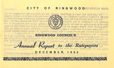
Pamphlet, Ringwood Council's Annual Report To The Ratepayers - December 1968, 1968
... , Residential Flat Control Planning Scheme, Immunisation, Home Help..., Dandenong Valley Authority, Residential Flat Control Planning Scheme ...City of Ringwood community information annual report for 1968, including sections covering Finance, General Valuation and Rater Payments, Property Ownership Changes, Refuse, Sanitary Serviced, Sewerage Connections to MMBW, Dandenong Valley Authority, Residential Flat Control Planning Scheme, Immunisation, Home Help, Elderly Citizens' Clubrooms, Library, Civic Centre, Golf Course, Sale of Council Land, Swimming Centre, Holiday Play Centre, Civic Week, Lake Reserve Improvements, Rubbish Dumping, Street Trees, Vandalism, White Ants, Street Construction, Fire Hazards, Dog Nuisance, House Numbering, Citizens' Advisory Service, Infant Welfare Centres, and a list of departing and current Council Representatives. Also includes general reminders regarding rat extermination, free firewood for age pensioners, overhanging vegetation, and spouses voting rights.Obituary - Mr. F.P. Dwerryhouse, Town Clerk for the past 9-1/2 years passed away on 6th December after a short illness.rinx -
 Eltham District Historical Society Inc
Photograph - Digital Photograph, Alan King, Original Kangaroo Ground Primary School No. 2105 building, Eltham-Yarra Glen Road, Kangaroo Ground, 28 December 2007
... , Nillumbik Planning Scheme. Published: Nillumbik Now..., Nillumbik Planning Scheme. Published: Nillumbik Now ...Kangaroo Ground's first school began in 1851 with 22 pupils from the district's ten families. It was a single room school located further south on the site, which also served as a Presbyterian church. The first teacher was Andrew Ross. The school building was used as a Post Office between 1854 and 1858 and during 1857 also served as a Court of Petty Sessions. With a growing farming community, a new building was warranted and the original Sate School No. 352 was closed and a new building, State School No. 2105 was oipened October 1, 1878. A residence for Head Teacher Henry Wallace School was erected in 1879 attached to the left of the school building. That residence is now home to the Andrew Ross Museum, which opened in 1993. Covered under Heritage Overlay, Nillumbik Planning Scheme. Published: Nillumbik Now and Then / Marguerite Marshall 2008; photographs Alan King with Marguerite Marshall.; p35This collection of almost 130 photos about places and people within the Shire of Nillumbik, an urban and rural municipality in Melbourne's north, contributes to an understanding of the history of the Shire. Published in 2008 immediately prior to the Black Saturday bushfires of February 7, 2009, it documents sites that were impacted, and in some cases destroyed by the fires. It includes photographs taken especially for the publication, creating a unique time capsule representing the Shire in the early 21st century. It remains the most recent comprehenesive publication devoted to the Shire's history connecting local residents to the past. nillumbik now and then (marshall-king) collection, kangaroo ground, eltham-yarra glen road, kangaroo ground primary school no. 2105, kangaroo ground state school, state school no. 2105 -
 Eltham District Historical Society Inc
Photograph, Fay Bridge, EDHS Heritage Excursion, Edendale Farm, 5 May 2018
... Overlay in the Nillumbik Planning Scheme. Our May excursion... Overlay in the Nillumbik Planning Scheme. Our May excursion ...May Excursion – Edendale Environs Edendale Community Environment Farm in Gastons Road, Eltham now operates as Nillumbik Council’s environmental centre. The historic homestead has undergone a significant restoration and there is on-going development of the site consistent with its community education purpose. The house and the gateway sculpture “The Fences Act” are covered by a Heritage Overlay in the Nillumbik Planning Scheme. Our May excursion will comprise a walk through the farm property and will radiate to other nearby places of historic interest. These will include the site of the Eltham North Adventure Playground to discuss its history and destruction by fire (see page 1 article). Also nearby is Colemans Corner where the early road system has undergone some unusual changes. If time permits we may visit some other nearby places of interest. - EDHS Newsletter No. 239 April 2018fay bridge collection, 2018-05-05, edendale community farm, edendale farm, eltham district historical society, heritage excursion, activities -
Glen Eira Historical Society
Letter - St Aloysius Church, Caulfield
... and historic significance of the church, recommending planning scheme... planning scheme control. It includes a front view photograph, which ...A series of correspondence dated between 21/08/1985 to 10/11/1988 regarding the Historic Buildings Council adding St Aloysius Church on Balaclava Road, Caulfield to the Historic Buildings Register. Four of the letters are between the Historic Buildings Council, the Caulfield Historical Society and the City of Caulfield. Copies of the replies by the Historical society (as indicated by handwritten notes in the letters) are not included in the file. A fifth letter dated 14/09/1989, addressed to Reverend Father John Fraser, Parish Priest at St Aloysius, advises him of the inclusion of St Aloysius on the National Trust Register due to its historic significance. Also included is a photocopy of the Caulfield Conservation study of St Aloysius, dated February 1994, by Andrew Ward. This study details the architectural features and historic significance of the church, recommending planning scheme control. It includes a front view photograph, which is not clear, and references.caulfield, catherine street, tonkin ray, st aloysius church, grey karen, fraser john rev. fr., catholic church, wills cathie, davies stephen, balaclava road, ballantyne r mr, ward andrew, city of caulfield, head stephen, moriarty bartholemew, de carle henry, mannix archbishop, caulfield historical society, caulfield conservation study, foundation stones, town halls, local officials and employees, registers, committees and inquiries, gothie (revival) architecture, architectural features. -
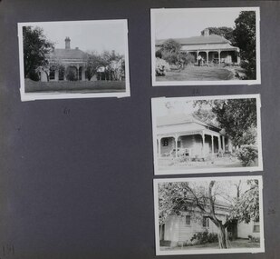 Glen Eira Historical Society
Album - Album page, Seymour Road, Circa 1972
... to add to the Glen Eira Planning Scheme (amongst others... to add to the Glen Eira Planning Scheme (amongst others ...This album was created in approximately 1972 as part of a project by the Caulfield Historical Society to assist in identifying buildings worthy of preservation. The album is related to a Survey the Caulfield Historical Society developed in collaboration with the National Trust of Australia (Victoria) and Caulfield City Council to identify historic buildings within the City of Caulfield that warranted the protection of a National Trust Classification. Principal photographer thought to be Trevor Hart, member of Caulfield Historical Society. Most photographs were taken between 1966-1972 with a small number of photographs being older and from unknown sources. All photographs are black and white except where stated, with 386 photographs over 198 pages. As at 22/08/2021, 61 Seymour Road is included in the HO179 Beemery Park Precinct which C204glen Amendment seeks to add to the Glen Eira Planning Scheme (amongst others). This is not yet finalised.Page 191 of Photograph Album with four photographs of two different properties on Seymour Road. One photo on the left, with the other three all on the right. Handwritten: 61 [under top left photo] / 32 [under top right photo] / 32 [beside bottom right photo] / 191 [bottom left]trevor hart, elsternwick, seymour road, late victorian, italianate style, verandahs, cast iron work, gardens -
 Bendigo Historical Society Inc.
Document - DEBORAH REEF PROJECT ENVIRONMENT EFFECTS STATEMENT
... and proposed planning scheme amendments upon which, the Deborah Reef... contained in the Environment Effects Statement and proposed planning ...Two page document. On top, first page ' Bendigo Mining N.L., Deborah Reef Project, Environment Effects Statement, Summary Brochure'. Poppet head on top LH corner of document. A map of central Bendigo is drawn on page 1 and shows the location of the proposed processing plant near the Airport. Further maps on page 2 and 3 show the North Deborah Mine Site, the pipeline route and the airfield site. The summary brochure provides an outline of the material contained in the Environment Effects Statement and proposed planning scheme amendments upon which, the Deborah Reef Project will be assessed. Page four lists the issues that impact on this submission: planning and land use; socio economic environment; traffic; discharges to air; water management; explosives storage and handling; subsidence; heritage; flora and fauna and landscape and visual assessment. The 16th March, 1989, is the date given for submissions to be lodged in regard to this project.Bendigo Mining N.Lbendigo, mining, deborah reef project -
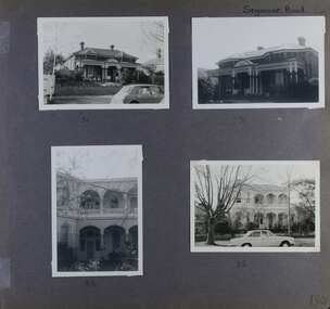 Glen Eira Historical Society
Album - Album page, Seymour Road, Circa 1972
... to add to the Glen Eira Planning Scheme (amongst others... to add to the Glen Eira Planning Scheme (amongst others ...This album was created in approximately 1972 as part of a project by the Caulfield Historical Society to assist in identifying buildings worthy of preservation. The album is related to a Survey the Caulfield Historical Society developed in collaboration with the National Trust of Australia (Victoria) and Caulfield City Council to identify historic buildings within the City of Caulfield that warranted the protection of a National Trust Classification. Principal photographer thought to be Trevor Hart, member of Caulfield Historical Society. Most photographs were taken between 1966-1972 with a small number of photographs being older and from unknown sources. All photographs are black and white except where stated, with 386 photographs over 198 pages. As at 22/08/2021, 51 Seymour Road is included in the HO179 Beemery Park Precinct which C204glen Amendment seeks to add to the Glen Eira Planning Scheme (amongst others). This is not yet finalised. Bellecourt (so named in 1989 according to Andrew Ward's Heritage Study) was originally named Beemery.Victorian Heritage Database HO62 Bellecourt 85 Seymour Road ELSTERNWICK https://vhd.heritagecouncil.vic.gov.au/places/35585 (as of 22/08/2021) "Beemery" at 85 Seymour Road, is an imposing ltalianate villa with arcaded asymmetrical facade built in 1891 for Charles Langdon. It has aesthetic, historical and social significance. Its aesthetic value rests with the facade which is highly representative of a not uncommon villa form of the late Victorian period. Its historical value derives from its association with the Langdon family in Caulfield (compare "Rosecraddock", "Tarqua" and "Hengar"). Its social value derives from its ability to demonstrate a lifestyle in late Victorian Caulfield.Page 190 of Photograph Album with four photographs of two different properties on Seymour Road.Handwritten: Seymour Road [top right] / 51 [under top left photo] / 51 [under top right photo] / 85 [under bottom left photo] / 85 [under bottom right photo] / 190 [bottom right]trevor hart, elsternwick, seymour road, late victorian, caulfield, beemery, bellecourt, house names, langdon family, charles langdon, cast iron work, verandahs, polychromatic brickwork, italianate style, arched balconies -
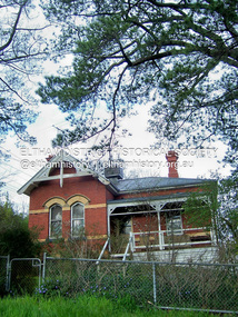 Eltham District Historical Society Inc
Photograph - Digital Photograph, Marguerite Marshall, Former Head Teacher's residence, Eltham Primary School, Dalton Street, Eltham, 7 September 2008
... offices. Covered under Heritage Overlay, Nillumbik Planning... offices. Covered under Heritage Overlay, Nillumbik Planning ...Built in 1891 for Head Teacher John Brown. His predecessor and the school's first Head Teacher, John Clark, lived in his own house 'Shoestring' in Metery Road, adjacent to the school. At the time of this photograph, the building was being used for before and after school care. Its present-day (2023) use is for school administration offices. Covered under Heritage Overlay, Nillumbik Planning Scheme. Published: Nillumbik Now and Then / Marguerite Marshall 2008; photographs Alan King with Marguerite Marshall.; p49 The former head teacher’s residence on 690 Main Road, was built in 1891 for the head teacher, John Brown. His predecessor David Clark lived in his own house known as Shoestring at Metery Road, possibly built in the late 1850s. With the school, Wingrove and Jarrold Cottages, it makes up the original Eltham township south of Dalton Street’s only group of 19th century buildings. The two Monterey Pines were popular vegetation in the late 19th and early 20th centuriesThis collection of almost 130 photos about places and people within the Shire of Nillumbik, an urban and rural municipality in Melbourne's north, contributes to an understanding of the history of the Shire. Published in 2008 immediately prior to the Black Saturday bushfires of February 7, 2009, it documents sites that were impacted, and in some cases destroyed by the fires. It includes photographs taken especially for the publication, creating a unique time capsule representing the Shire in the early 21st century. It remains the most recent comprehenesive publication devoted to the Shire's history connecting local residents to the past. nillumbik now and then (marshall-king) collection, dalton street, eltham, eltham primary school, headmaster's residence, main road, state school no. 209 -
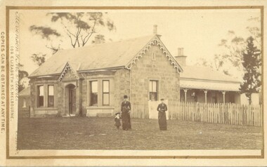 Bacchus Marsh & District Historical Society
Photograph, Stone Villa house 4 Bennett Street Bacchus Marsh 1883
... as a heritage property in the Moorabool Shire planning scheme... as a heritage property in the Moorabool Shire planning scheme ...The house depicted in this image was constructed in 1865 for James Young a prominent local businessman and participant in community affairs. James Young left Bacchus Marsh in 1869. In 1870 Stone Villa was purchased by local solicitor Francis Gell. In 1872 it was bought by William Collyer. For a time before 1883 it was used as a school operated by Mr Thomas Kissock and his wife. From 1883 until 1922 it was used as a parsonage by the Church of England. In 1922 it was sold to Frederick Slack as a private residence. Since Slack's ownership there have been other owners. As of April 2024 it remains as a private residence and is listed as a heritage property in the Moorabool Shire planning scheme. The identity of the two women and young girl in the foreground of the image has not been established. One of the women, and the child are possibly the wife and daughter of the Rev A.C. McCausland who was the Church of England Vicar in Bacchus Marsh from 1872 until 1885 and would have resided in this house in 1883 when this picture was produced.An early visual record of one of the most culturally and architecturally significant nineteenth century stone houses in Bacchus Marsh.Small sepia 'carte de visite' style unframed photograph on card with gold border framing photograph. Housed in the album, 'Photographs of Bacchus Marsh and District in 1883 by Stevenson and McNicoll', the Jeremeas Family Album. The photo is of a stone dwelling with an ornate gable above the inset front door which is flanked by two double windows, one of which is a bay window. The gable roof line bears ornate woodwork. A weatherboard extension with verandah has been added to the rear of the house, running north-south. A picket fence lines the block to the side of the dwelling. Two elegantly dressed women, both holding a furled umbrella, stand at the front, one holding the hand of a little girl.Printed On the front: Stevenson & McNicoll. Photo. 108 Elizabeth St. Melbourne. COPIES CAN BE OBTAINED AT ANY TIME. On the back: LIGHT & TRUTH inscribed on a banner surmounted by a representation of the rising sun. Copies of this Portrait can be had at any time by sending the Name and Post Office Money Order or Stamps for the amount of order to STEVENSON & McNICOLL LATE BENSON & STEVENSON, Photographers. 108 Elizabeth Street, MELBOURNE. Hand written on the reverse: 'Stone Villa built by James Young 1860 (sic) as his private residence, later as a school (Mr and Mrs Kissock proprietors) bought by CofE for Vicarage 1883-1922. Courtesy of Mrs J Jeremeas, Photo 1883' james young 1816-1871, houses, stone villa bacchus marsh, clergy residences, bacchus marsh vic. history, schools bacchus marsh, stevenson and mcnicoll 1883 photographs of bacchus marsh and district -
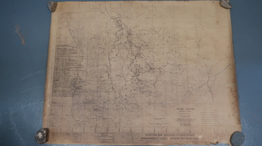 Kiewa Valley Historical Society
Map - Kiewa Scheme General Plan
... Map - Kiewa Scheme General Plan...Yellowed paper with brown print. Kiewa Scheme general plan... paper with brown print. Kiewa Scheme general plan showing its ...Existing and possible future roads are numbered and named 1 - 45. The plan is based on an aerial photos taken March 1945. It includes revisions up to 1951. Signed by H.H.C. Williams, construction engineer. Mountains, rivers, roads and SECV places are named, also SECV infrastructure and construction eg. workers camps, Power stations.Significant for the information re the Kiewa Hydro Electric Scheme's development.Yellowed paper with brown print. Kiewa Scheme general plan showing its development. A lot of information is recorded. Note: Dyeline print was used which causes fading when exposed to light. Handwritten: 'Bob Duncan'bob duncan, kiewa hydro electric scheme, secv, khes development -
 Eltham District Historical Society Inc
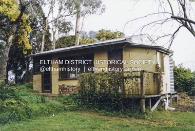
Photograph, Belle Vue, Livingstone Road, Eltham, c.1960, 1960c
... the Nillumbik Planning Scheme. Despite that overlay, most... the Nillumbik Planning Scheme. Despite that overlay, most ...Photo taken at time of ownership by Eric Staff. Originally purchased by pioneer Eltham farmer Henry Stooke, Belle Vue farm comprised about 56 ha (140 acres) extending northerly from the northern boundary of Holloway’s 1851 Little Eltham subdivision. On the present day map the southern boundary was just north of Elsa Court and Grove Street. The western boundary was the Diamond Creek and extended northerly to Main Road where it turns easterly towards Research. It was traversed by the main road to Kangaroo Ground and beyond and from 1912 by the railway to Hurstbridge. From 1895 the farm was owned by William Williams and his wife Mary Ann. In 1914-1915 they built a new house now known as “Belle Vue”. They sold the land in 1920 and residential subdivision began soon after that. “Belle Vue” remains today on a large residential lot in Livingstone Road. The house and many old trees on the site have been subject to a heritage overlay under the Nillumbik Planning Scheme. Despite that overlay, most of the heritage trees were removed during sub-division and development of the property.Digital file only from scan of copy on loan to EDHSbelle vue, eltham, eric staff, houses, livingstone road, staff family -
 Eltham District Historical Society Inc
Photograph - Digital Photograph, Marguerite Marshall, Former Methodist Church, Plenty, 5 August 2008
... Planning Scheme. Published: Nillumbik Now and Then / Marguerite... Planning Scheme. Published: Nillumbik Now and Then / Marguerite ...In 1924, the Methodist Church opened at the corner of River Ave and Yan Yean Road, Plenty. It was a simple weatherboard gabled building. The church developed a strong community life with celebrations as well as worships, Sundays Schools and social events. It closed in 1979. Covered under Heritage Overlay, Nillumbik Planning Scheme. Published: Nillumbik Now and Then / Marguerite Marshall 2008; photographs Alan King with Marguerite Marshall.; p113 In 1924, the Methodist Church, (which closed in 1976), opened at the corner of River Avenue and Yan Yean Road. Church members including George Starling and Ernest Osmond, built the simple weatherboard gabled building.3 The church developed a strong community life, with celebrations as well as worship through Sunday School anniversaries, picnics, harvest festivals and youth groups. Many volunteers worked hard for the church - teaching Sunday School and ferrying young people to events, sometimes in the backs of trucks and furniture vans. Children from the Sutherland Homes were brought to church by their Matron – a ‘grim martinet’! Members included the Ashton, Reid, Harris, McLachlan, Hopkin, Rose and Stuchbery families. The first wedding was for Vida McLachlan and Ray Stuchbery.4This collection of almost 130 photos about places and people within the Shire of Nillumbik, an urban and rural municipality in Melbourne's north, contributes to an understanding of the history of the Shire. Published in 2008 immediately prior to the Black Saturday bushfires of February 7, 2009, it documents sites that were impacted, and in some cases destroyed by the fires. It includes photographs taken especially for the publication, creating a unique time capsule representing the Shire in the early 21st century. It remains the most recent comprehenesive publication devoted to the Shire's history connecting local residents to the past. nillumbik now and then (marshall-king) collection, methodist church, plenty -
 Eltham District Historical Society Inc
Photograph - Digital Photograph, Alan King, Wellers Restaurant, 150 Eltham-Yarra Glen Road, Kangaroo Ground, 23 January 2008
... Overlay, Nillumbik Planning Scheme. Published: Nillumbik Now... Overlay, Nillumbik Planning Scheme. Published: Nillumbik Now ...Originally Wellers Hotel, it was constructed by Edward Weller in 1872. Following his death in 1883 it was taken over by his widow, Mary Weller. The hotel was delicensed in 1909 and converted to a private residence. Around 1920 William Pitman bought the property, succeeded by his son Vernon who coined the term Pittman's Corner. Vernon and Isabel Pitman owned the house form 1945-1973. Following Vernon's death, Isabel remained there till her death in 1983. The property was converted to a restaurant in 1984 by owners Robert and Kath Hendry who undertook extensive renovations in 1988. Shawn and Stephanie Wolfe purchased the property from the Hendrys in 2003 and introduced live entertainment with many famous bands and entertainers from the 1960s, 1970s and 1980s performing there, including James Reyne, Daryl Barithwaite, Brian Cadd and Billy Thorpe. In 2014 the Wolfe's sold the property and the entire contents were sold at auction. New (local ) owners Gregory Anderson, Craig Jones and Steve Gist refurbished the property and relaunched it as Fondata 1872 in 2017. Covered under Heritage Overlay, Nillumbik Planning Scheme. Published: Nillumbik Now and Then / Marguerite Marshall 2008; photographs Alan King with Marguerite Marshall.; p87This collection of almost 130 photos about places and people within the Shire of Nillumbik, an urban and rural municipality in Melbourne's north, contributes to an understanding of the history of the Shire. Published in 2008 immediately prior to the Black Saturday bushfires of February 7, 2009, it documents sites that were impacted, and in some cases destroyed by the fires. It includes photographs taken especially for the publication, creating a unique time capsule representing the Shire in the early 21st century. It remains the most recent comprehenesive publication devoted to the Shire's history connecting local residents to the past. nillumbik now and then (marshall-king) collection, eltham-yarra glen road, fondata 1872, kangaroo ground, wellers restaurant, billy thorpe, brian cadd, craig jones, daryl barithwaite, edward weller, gregory anderson, hotels, james reyne, kath hendry, mary weller, restaurants, robert hendry, shawn wolfe, stephanie wolfe, steve gist -
 Eltham District Historical Society Inc
Photograph - Digital Photograph, Alan King, Eltham Hotel, cnr Main Road and Pitt Street, 28 December 2007
... Overlay, Nillumbik Planning Scheme. Published: Nillumbik Now... Overlay, Nillumbik Planning Scheme. Published: Nillumbik Now ...The Eltham Hotel is the oldest continually operating hotel in the Eltham district. Initially referred to as the Little Eltham Hotel, it has been known as the Eltham Hotel since the mid-1850s through to the present except for a brief period as the Eltham Tavern in the late 1980s. The original hotel opened in 1854 by Richard Warren was built by Benjamin Oliver Wallis. The Fountain of Friendship Hotel on the opposite side of Maria Street (Main Road) opened shortly after. The hotel was a well-known resting place for gold diggers during the gold rush at Woods’ Point and Warren would buy the gold from the diggers. Warren ran into financial difficulties and determined to return to England. Wallis bought the hotel in 1861 and ran it till 1886 when he sold it to Christopher Watson Snr. When Christopher Watson Snr died a year after purchase, his son Christopher took over until his death in 1909 when it passed to wife Emily and then their youngest son, Herbert James (Jim) Watson in 1915. In July 1925, Jim Watson demolished the original building and, in its place, erected a modern hotel which remains the foundation of the present-day Eltham Hotel. Covered under Heritage Overlay, Nillumbik Planning Scheme. Published: Nillumbik Now and Then / Marguerite Marshall 2008; photographs Alan King with Marguerite Marshall.; p41This collection of almost 130 photos about places and people within the Shire of Nillumbik, an urban and rural municipality in Melbourne's north, contributes to an understanding of the history of the Shire. Published in 2008 immediately prior to the Black Saturday bushfires of February 7, 2009, it documents sites that were impacted, and in some cases destroyed by the fires. It includes photographs taken especially for the publication, creating a unique time capsule representing the Shire in the early 21st century. It remains the most recent comprehenesive publication devoted to the Shire's history connecting local residents to the past. nillumbik now and then (marshall-king) collection, eltham, eltham hotel, main road, pitt street -
 Robin Boyd Foundation
Document - Script, Robin Boyd, The Flying Dogtor. Episode 9 The Helping Hand, 1963
... . But Crafty Carson Carpetbag and Old Man Redback lay waiting, scheming... lay waiting, scheming, planning their next nasty surprise ...Elvis resumed pouring the rainmaking powder onto the clouds and the Dogtor could not loosen the logs that were blocking the creek bed. Because the Dogtor had been so nice to Elvis, in the end, Elvis helped the Dogtor dislodge the logs and the flood subsided. But Crafty Carson Carpetbag and Old Man Redback lay waiting, scheming, planning their next nasty surprise.The Flying Dogtor" series was broadcast on Australian Television Network (later becoming the Seven Network) between February and April 1964 (see item D254 for schedule).Typewritten, carbon copy, foolscap, 2 pagesthe flying dogtor, robin boyd, crawford productions, manuscript -
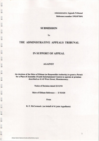 Eltham District Historical Society Inc
Document - Folder, Ron F. McCormack, Appeal against Eltham Shire Permit granted for a propsed Youth Enterntainment Centre, 41-43 Were Street, Montmorency, 1993-1994
... withing the Eltham Planning Scheme definition of an 'amusement... withing the Eltham Planning Scheme definition of an 'amusement ...In 1993 Eltham Shire Council issued a permit to Michael Muzur, Terry Lant and Andrew McMillan to redevelop the former Montmorency Theatre/Bingo Hall at 41-43 Were Street as an alcohol-free youth entertainment centre. Ron McCormack, retired former JP on behalf of 41 Joint Appellants consisting of local residents and traders successfully lobbied the community and won an Appeal to have the permit cancelled as unsuitable development. The Administrative Appeal Tribunal found that the proposed development came withing the Eltham Planning Scheme definition of an 'amusement parlour' and that the playing of pool an amusement machines would be the focus of the centre and unlikely to attract older age groups. The tribunal was not satisfied the applicants had sufficient knowledge or where with all required for the successful running of this type of operation. With respect to the objectors, the Tribunal did not accept that a responsibly managed and attractive amusement parlour could not coexist near the adjoining residential area and without detriment to the commercial centre. At a Council meeting on June 7, 1994 councillors requested a report outlining criteria to be used to assess planning applications for youth entertainment venues given the Tribunal's view that a poorly managed facility in a small neighbourhood shopping centre, particularly in such close proximity to a residential area would not only have the potential to increase perceived youth problems, but could jeopardise the prospects of future proposals. Ron McCormack moved to Montmorency from Coburg in the early 1980s and from then sat on the bench at Eltham Courthouse when Police requested assistance out of hours, until the eventuial closure of the Courthouse. montmorency theatre, montmorency bingo hall, 41-43 were street, youth entertainment centre, eltham shire council, planning permit, administrative appeals tribunal, ron f mccormack -
 Eltham District Historical Society Inc
Photograph - Digital Photograph, Alan King, Garden Hill, Eltham-Yarra Glen Road, Kangaroo Ground, 3 February 2008
... Planning Scheme. Published: Nillumbik Now and Then / Marguerite... Planning Scheme. Published: Nillumbik Now and Then / Marguerite ...The original house was built around 1850 was one of Kangaroo Ground's earliest homes, part of which remains today. Built by Scottish farmer Andrew Harkness who acquired the property in 1849 at the top of the hill with magnificent panoramic views as far as Kinglake, the same year he married Sarah Oswin. The property was known as Garden Hill from at least 1865. Andrew and Sarah had four sons and five daughters. Harkness was a founder of the Kangaroo Ground School and one of the first to suggest establishing the Eltham District Road Board (1858-71) of which he was a member, the pre-cursor to the Shire of Eltham (1871-1994). He was also a Trustee of the Kangaroo Ground Cemetery. His daughter Fanny married farmer Alexander White who purchased the property in 1893. Alexander White died in 1906 and ownership transferred to Fanny White. Son, Robert White was a Councillor of the Shire of Eltham at the time the Shire acquired two acres of land on the adjacent property from the Mess brothers for the creation of the Shire of Eltham Memorial Park (1921) in which the Shire of Eltham War Memoirial tower was erected (1926). Fanny White donated a small section of land from the Garden Hill property to facilitate entry access to the park. The White family sold the property to Sir Herbert Gepp in 1925. Covered under Heritage Overlay, Nillumbik Planning Scheme. Published: Nillumbik Now and Then / Marguerite Marshall 2008; photographs Alan King with Marguerite Marshall.; p29This collection of almost 130 photos about places and people within the Shire of Nillumbik, an urban and rural municipality in Melbourne's north, contributes to an understanding of the history of the Shire. Published in 2008 immediately prior to the Black Saturday bushfires of February 7, 2009, it documents sites that were impacted, and in some cases destroyed by the fires. It includes photographs taken especially for the publication, creating a unique time capsule representing the Shire in the early 21st century. It remains the most recent comprehenesive publication devoted to the Shire's history connecting local residents to the past. nillumbik now and then (marshall-king) collection, kangaroo ground -
 Stawell Historical Society Inc
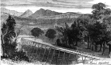
Drawing, Stawell Water Supply Bovine Aqueduct 1881 -- Sketch
... 5th 1881. The Grampian scheme planned by the the Borough... 5th 1881. The Grampian scheme planned by the the Borough ...Sketches of Stawell Water Supply Bovine Aqueduct October 5th 1881. The Grampian scheme planned by the the Borough Engineer John D'Alton. D'Alton's suggestion was that the water be carried from the source in an open channel two miles, then in a flume of timber. Later surveyed and planned a tunnel on a good line - to reduce the flume 72 miles and the main to Stawell to 15 miles. This sketch (illustrated Australian News October 5, 1881).Black and white photograph of a sketch a bush scene with mountains in background. The sketch depicts a trestle bridge construction. The Bovine Aqueduct stawell water supply -
 Eltham District Historical Society Inc
Photograph, Fay Bridge, Footbridge, Fort Knox Self Storage, 197 Sherbourne Road, Eltham, n.d
... under the Nillumbik Planning Scheme. The basis of this overlay... under the Nillumbik Planning Scheme. The basis of this overlay ...The footbridge which extended from the facility to the landscaped garden and water features is now gone. The footbridge and garden were previously part of a former hat factory in Sherbourne Road Eltham which has in the past been used for various purposes and presently a self storage business. The Karingal Yallock Creek passes through the front of the land and the creek environs are the subject of significant and unusual landscaping works, including some cascading water channels. Some of the landscaping was damaged by the Christmas Day floods of 2011, but the main elements remain intact. The landscaped area (as distinct from the factory itself) is the subject of a Heritage Overlay under the Nillumbik Planning Scheme. The basis of this overlay is a Heritage Report by Graeme Butler and Associates in 2006. As well as an assessment of the landscaped area, it includes one background information on the history of the site (although a complete history would require more research). The site was part of Crown Portion 3 of the Parish of Nillumbik that remained as the Montmorency Farm until early in the twentieth century. The 1911 subdivision of this farm created Lot 7 of some seven acres, which is the site of this factory. The Heritage Report lists the various owners of the site. From the rate records and aerial photos it is concluded that the site was used as an orchard and farmland until the 1940s. William F Crellin, orchardist, owned the site from 1912 to 1923. Then Edmund Williams owned it until 1951. In 1955 the site was owned by Rupert V. Kirsch and this is the name anecdotally associated with the hat factory, where the well-known brand of Fayrefield Hats were manufactured. There is some belief that this was built about the time of the Second World War and that hats for the armed forces were made there.fay bridge collection, eltham, fayrefield hat factory, foot bridge, sherbourne road, footbridge, fort knox eltham -
 Eltham District Historical Society Inc
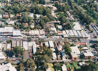
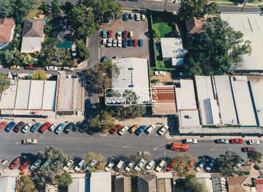
Photograph - Aerial Photograph, Montmorency Shopping Village, Were Street, Montmorency, 1994
... that the proposed development came withing the Eltham Planning Scheme... that the proposed development came withing the Eltham Planning Scheme ...Aerial photographs of Montmorency Shopping Village with a central focus on the former Montmorency Theatre and Bingo Hall situated at 41-43 Werte Street. In 1993 Eltham Shire Council issued a permit to Michael Muzur, Terry Lant and Andrew McMillan to redevelop the former Montmorency Theatre/Bingo Hall at 41-43 Were Street as an alcohol-free youth entertainment centre. Ron McCormack, retired former JP on behalf of 41 Joint Appellants consisting of local residents and traders successfully lobbied the community and won an Appeal to have the permit cancelled as unsuitable development. The Administrative Appeal Tribunal found that the proposed development came withing the Eltham Planning Scheme definition of an 'amusement parlour' and that the playing of pool an amusement machines would be the focus of the centre and unlikely to attract older age groups. The tribunal was not satisfied the applicants had sufficient knowledge or where with all required for the successful running of this type of operation. With respect to the objectors, the Tribunal did not accept that a responsibly managed and attractive amusement parlour could not coexist near the adjoining residential area and without detriment to the commercial centre. At a Council meeting on June 7, 1994 councillors requested a report outlining criteria to be used to assess planning applications for youth entertainment venues given the Tribunal's view that a poorly managed facility in a small neighbourhood shopping centre, particularly in such close proximity to a residential area would not only have the potential to increase perceived youth problems, but could jeopardise the prospects of future proposals. Ron McCormack moved to Montmorency from Coburg in the early 1980s and from then sat on the bench at Eltham Courthouse when Police requested assistance out of hours, until the eventuial closure of the Courthouse. montmorency theatre, montmorency bingo hall, 41-43 were street, youth entertainment centre, eltham shire council, planning permit, administrative appeals tribunal, ron f mccormack, aerial photograph -
 Eltham District Historical Society Inc
Photograph - Aerial Photograph, Montmorency Shopping Village, Were Street, Montmorency, 1994
... that the proposed development came withing the Eltham Planning Scheme... that the proposed development came withing the Eltham Planning Scheme ...Aerial photographs of Montmorency Shopping Village with a central focus on the former Montmorency Theatre and Bingo Hall situated at 41-43 Werte Street. In 1993 Eltham Shire Council issued a permit to Michael Muzur, Terry Lant and Andrew McMillan to redevelop the former Montmorency Theatre/Bingo Hall at 41-43 Were Street as an alcohol-free youth entertainment centre. Ron McCormack, retired former JP on behalf of 41 Joint Appellants consisting of local residents and traders successfully lobbied the community and won an Appeal to have the permit cancelled as unsuitable development. The Administrative Appeal Tribunal found that the proposed development came withing the Eltham Planning Scheme definition of an 'amusement parlour' and that the playing of pool an amusement machines would be the focus of the centre and unlikely to attract older age groups. The tribunal was not satisfied the applicants had sufficient knowledge or where with all required for the successful running of this type of operation. With respect to the objectors, the Tribunal did not accept that a responsibly managed and attractive amusement parlour could not coexist near the adjoining residential area and without detriment to the commercial centre. At a Council meeting on June 7, 1994 councillors requested a report outlining criteria to be used to assess planning applications for youth entertainment venues given the Tribunal's view that a poorly managed facility in a small neighbourhood shopping centre, particularly in such close proximity to a residential area would not only have the potential to increase perceived youth problems, but could jeopardise the prospects of future proposals. Ron McCormack moved to Montmorency from Coburg in the early 1980s and from then sat on the bench at Eltham Courthouse when Police requested assistance out of hours, until the eventuial closure of the Courthouse. montmorency theatre, montmorency bingo hall, 41-43 were street, youth entertainment centre, eltham shire council, planning permit, administrative appeals tribunal, ron f mccormack, aerial photograph