Showing 281 items
matching shire of stawell
-
 Stawell Historical Society Inc
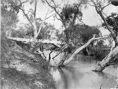
Photograph, Glenorchy Bridge on the Wimmera River 1866
... of Photographs by Mr. O.G. Armstrong as commissioned by the Shire... of Photographs by Mr. O.G. Armstrong as commissioned by the Shire ...Glenorchy Bridge Wimmera River. Part of a collection of Photographs by Mr. O.G. Armstrong as commissioned by the Shire of Stawell for the Inter-colonial and Paris Exhibition in Melbourne in 1866. Prior to the construction of this bridge in 1860, there existed two forwards across the Wimmer River at Glenorchy. One was 2 miles on the Stawell side of Glenorchy and 500 metres from the present railway bridge. It was well made, stone floor and can be seen today. The second was located 800 metres downstream of the town and was known as Stuart’s Crossing. These Fords were popular crossing spots for Bullock Drays which were delayed for days during floods before the bridge was built. The original Bridge was built near the site of the present ‘old’ bridge. stawell -
 Stawell Historical Society Inc
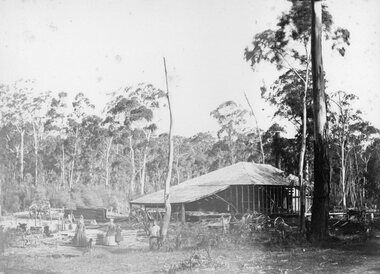
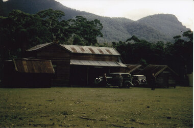
Photograph, Saw Mills at Childe’s Glenbower Creek in Halls Gap 1866
... by the Shire of Stawell for the Inter-colonial and Paris Exhibition... by the Shire of Stawell for the Inter-colonial and Paris Exhibition ...Saw Mills Halls Gap (Childe’s Glenbower Creek). Part of a collection of Photographs by Mr. O.G. Armstrong as commissioned by the Shire of Stawell for the Inter-colonial and Paris Exhibition in Melbourne in 1866. During the years of gold, the hardwood forests around Stawell were ravaged to provide timber for the mines. It was used undergrounds to shore up workings, and millions of feet of it were fed into furnaces and kilns in which the quartz was roasted. In the years after the gold boom, hardwood from the Grampians was milled for building timber. Wherever there are large tracts of natural bushland, fires are always a danger. A huge fire in January 1939 caused havoc in the Grampians, burning out towns and sawmills such as the one pictured. There have been no sawmills in the Grampian since that fire. stawell industry -
 Stawell Historical Society Inc
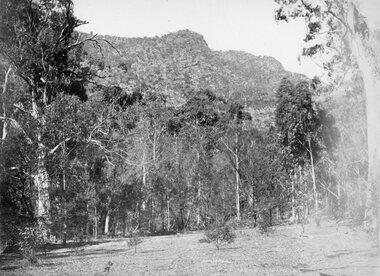
Photograph, Grampians Sunrise over the Saw Mills 1866
... by the Shire of Stawell for the Inter-colonial and Paris Exhibition... by the Shire of Stawell for the Inter-colonial and Paris Exhibition ...Grampians (Sunrise over the Saw Mills). Part of a collection of Photographs by Mr. O.G. Armstrong as commissioned by the Shire of Stawell for the Inter-colonial and Paris Exhibition in Melbourne in 1866. The Grampians were first sighted by Major Thomas Mitchell on the 11th of July 1836. Four days later he and a small party climbed its highest peak and named it Mount William. Owing to the lateness of arrival at the summit they had to spend a very cold and miserable night. Whilst in the Grampians, which he so named because of their likeness to his native Scotland. He collected about 150 plants and sent them to the Professor of Botany, John Lindley at the University of London. It is now known there about 900 different flowering plants in the Grampians, over one third of all those growing in Victoria. stawell industry -
 Stawell Historical Society Inc
Photograph, Great Western 1866
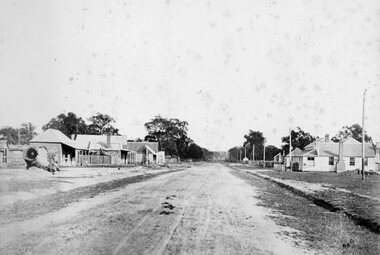
... . O.G. Armstrong as commissioned by the Shire of Stawell.... O.G. Armstrong as commissioned by the Shire of Stawell ...Great Western. Part of a collection of Photographs by Mr. O.G. Armstrong as commissioned by the Shire of Stawell for the Inter-colonial and Paris Exhibition in Melbourne in 1866. Great Western began as a changing station on Concongella, northeast of the present Township. The gold rush in Great Western began in 1858 and soon after a post office and store opened. A Township was surveyed and lots sold in October 1858. The gold soon passed and the diggers went on, leaving a small settlement. In 1863 Jean Pierre Trouette and Emile Bampied, his brother-in-law, planted the first vines and build the first winery, thus setting a firm foundation upon which the present wine industry has been built. Telegraph poles and wires visible. Bakery visible in distance on right of road, looking west. stawell -
 Stawell Historical Society Inc
Photograph, Grampians at Halls Gap 1866
... by Mr. O.G. Armstrong as commissioned by the Shire of Stawell... by Mr. O.G. Armstrong as commissioned by the Shire of Stawell ...Grampians Halls Gap. Part of a collection of Photographs by Mr. O.G. Armstrong as commissioned by the Shire of Stawell for the Inter-colonial and Paris Exhibition in Melbourne in 1866. From about 1860 there was agitation for a water supply, not only for Stawell but for the Wimmer Mallee as well. In 1887 Wartook was adopted as the first reservoir for the Wimmer. Stawells water supply was designed by Mr. John D’Alton. The scheme came from Fyan’s Creek via Wooden Fluming and a Syphon and finally through the mountain in a tunnel, before being piped to a reservoir on Big Hill. The system was completed in December 1881 and although there have been modifications, basically it has not been changed to this day. The Wimmera Mallee stock and domestic system from the Grampians is the largest system of its kind in the world, the latest edition being like Belfield and piping of Wimmera channels. stawell -
 Stawell Historical Society Inc
Photograph, Glenorchy 1866
... . Armstrong as commissioned by the Shire of Stawell for the Inter.... Armstrong as commissioned by the Shire of Stawell for the Inter ...Glenorchy. Part of a collection of Photographs by Mr. O.G. Armstrong as commissioned by the Shire of Stawell for the Inter-colonial and Paris Exhibition in Melbourne in 1866. Glenorchy township began as a resting place for bullock teams and travellers in the 1840s. In 1847, John Gleeson built the Four Posts Inn, which then became the name of the settlement. Gleeson is credited with naming the settlement Glenorchy, meaning tumbling waters, after his birth place in Scotland. In 1865 the Township consisted of a church, school, three hotels the Four Post Inn built 1847, Royal Hotel built 1855, The Royal Mail Hotel built1862. As well as boot makers, a blacksmith, stores, butcher and other enterprises. The town was a postal centre served by three coaches each day until the advent of the railway. stawell -
 Stawell Historical Society Inc
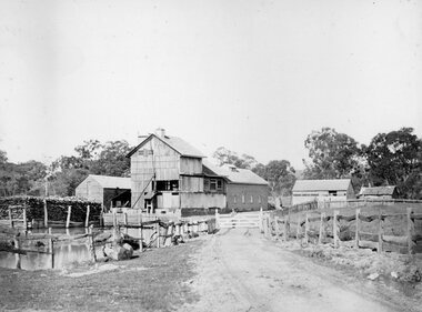
Photograph, Fountain Head Brewery at Armstrong 1866
... of Photographs by Mr. O.G. Armstrong as commissioned by the Shire... of Photographs by Mr. O.G. Armstrong as commissioned by the Shire ...Fountain Head Brewery Armstrong's. Part of a collection of Photographs by Mr. O.G. Armstrong as commissioned by the Shire of Stawell for the Inter-colonial and Paris Exhibition in Melbourne in 1866. The brewery, a three-storey high building, was established close to two streams which joined the Concongella Creek near Armstrong, although the water required to run the brewery was obtained from a natural underground spring which is still visible. Further findings of Gold in Victoria around 1859-1860 brought a large rush of miners to the area. Some stayed on to become merchants, farmers, etc. Jens Kofoed, a shipwright from the Netherlands, was one who came to the area at this time. He and his family move to Armstrong in 1860, establishing the Fountain Head Brewery, which employed quite a number of people for about 40 years. stawell industry -
 Stawell Historical Society Inc
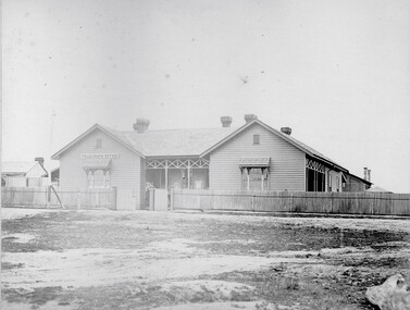
Photograph, Telegraph Office Pleasant Creek Stawell 1866
... by the Shire of Stawell for the Inter-colonial and Paris Exhibition... by the Shire of Stawell for the Inter-colonial and Paris Exhibition ...Telegraph Office Pleasant Creek Stawell. Part of a collection of Photographs by Mr. O.G. Armstrong as commissioned by the Shire of Stawell for the Inter-colonial and Paris Exhibition in Melbourne in 1866. The first post was office was erected at Commercial Street, Pleasant Creek in the goldfields, in June 1858, by J Harding and was a portable one. In October 1860 the first permanent Telegraph Office was erected by Cormick and Irvine for £329. In the same month the Post Office was removed from Commercial St in the Goldfields to the rear of the Telegraph office in Stawell. In February 1862 Edmond Johnson was appointed manager of Electrical Telegraph, Collector of Imposts and acting Postmaster. This building was later used as a private dwelling. It is situated in Lesley Street at the rear of the Pleasant Creek Courthouse although the right-hand wing has been removed. stawell -
 Stawell Historical Society Inc
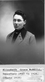
Photograph, Elizabeth Grace McNeill -- Secretary STAWELL SHIRE COUNCILLORS 1917-1924, Photo1918 -- Studio Portrait
... Elizabeth Grace McNeill -- Secretary STAWELL SHIRE...Portrait - Elizabeth Grace McNeill - Secretary STAWELL... SHIRE COUNCILLORS 1917-1924. Photo1918 Stawell Government ...Portrait - Elizabeth Grace McNeill - Secretary STAWELL SHIRE COUNCILLORS 1917-1924. Photo1918stawell government -
 Stawell Historical Society Inc
Map, Plan of Division Line between Ararat and Stawell Shires 1877, 1877
... Grampians Halls Gap Black Range Stawell Shire Ararat Shire... grampians Grampians Halls Gap Black Range Stawell Shire Ararat Shire ...Grampians Halls Gap Black Range Stawell Shire Ararat Shire Crowlands TownshipVery Large Map Printed on Linen with Table of bearingsExamined by H.C. Malcolm 28.12.77 Traced By D.H. Meike 28.12.77survey -
 Stawell Historical Society Inc
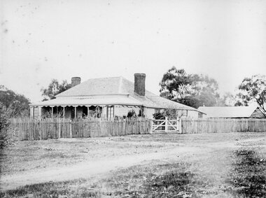
Photograph, Concongella Home Station 1866
... of Photographs by Mr. O.G. Armstrong as commissioned by the Shire... of Photographs by Mr. O.G. Armstrong as commissioned by the Shire ...Concongella Home Station. Part of a collection of Photographs by Mr. O.G. Armstrong as commissioned by the Shire of Stawell for the Inter-colonial and Paris Exhibition in Melbourne in 1866. The Concongella Station consisted of 57,000 acres along the Concongella Creek. It was first part of Allanvale, taken up by John Allan in 1841. Allen's right to the 137,000 acres of Allanvale was contested and as a result, the northern section of 57,000 acres was renamed Concongella. Concongella Run, with the homestead on the creek of the same name just east of Stawell, occupied the lands between the later named Deep Lead and Great Western. It was on this station that William McLaughlin a sheep minder discovered gold at Pleasant Creek in 1853. Doctor Blundell held Concongella under licence at this time and through until 1858. The homestead has been gone for many years and only some lonely graves remain at this vicinity. stawell -
 Stawell Historical Society Inc
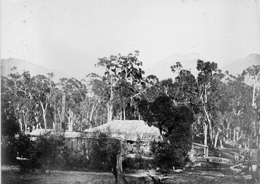
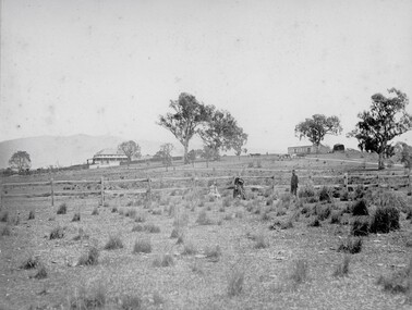
Photograph, Ledcourt Home Station in the Grampians 1866
... of Photographs by Mr. O.G. Armstrong as commissioned by the Shire... of Photographs by Mr. O.G. Armstrong as commissioned by the Shire ...Ledcourt Home Station Grampians. Part of a collection of Photographs by Mr. O.G. Armstrong as commissioned by the Shire of Stawell for the Inter-colonial and Paris Exhibition in Melbourne in 1866. This was one of, if not the first, Squatters Sheep Station in this region. The first licence of Ledcourt was granted to Robert Briggs in about 1840. In 1842 the run passed to Benjamin Boyd of Whaling and Boydtown Banking fame in NSW. He held it for six years. It was then taken over by Thomas Young and John Carfrae, who divided it into 3 holdings. Ledcourt 74,500 acres, Newington 74,500 acres and Swinton, 52,000 acres. It again changed hands in 1859, this time to Henry Alfred and Joseph De Little. It has changed hands several times since and in later years owned by the Cooper family and now the Marr family. The date of the actual building is uncertain, but it is known that the stone used in the building was carted from the Mount Difficult area in the Grampians and some of the courtyard paving shows convict origin. Looking up hill with Homestead on left and stone stables or right.stawell -
 Stawell Historical Society Inc
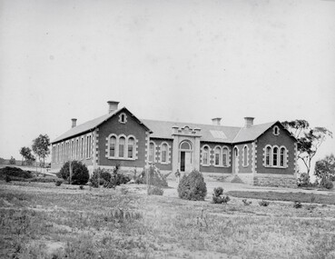
Photograph, Pleasant Creek Hospital 1866
... of Photographs by Mr. O.G. Armstrong as commissioned by the Shire... of Photographs by Mr. O.G. Armstrong as commissioned by the Shire ...Pleasant Creek Hospital. Part of a collection of Photographs by Mr. O.G. Armstrong as commissioned by the Shire of Stawell for the Inter-colonial and Paris Exhibition in Melbourne in 1866. Due to a public outcry for medical services on the goldfield a public meeting was held in the Olympic Theatre at Deep Lead on the 7th of August 1858. It appointed a 50 man committee to establish a hospital at Pleasant Creek. A temporary Tent structure was soon erected at Doctors Hill, situated midway between Deep Lead and Commercial Street Pleasant Creek, just South of the later Western Highway. The site is now marked by a commemorative stone. Within two months the committee had collected £600 in subscriptions, a government Grant for £2500 and acquired 10 acres of land. The foundation stone of the hospital building was laid on 21st December 1860 and the building completed and occupied by 21st June 1861. In the 1930’s the hospital moved to the centre of Stawell in Sloane Street and the buildings then taken over by the Pleasant Creek Training Centre. Brick hospital building with two ward wings and central front door. Man standing on steps.stawell health -
 Stawell Historical Society Inc
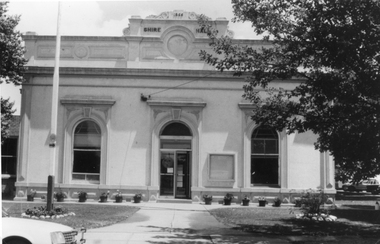
Photograph, Stawell Shire Hall Built in 1866
... Stawell Shire Hall Built in 1866...Stawell Shire Hall built 1866. These photographs... grampians Stawell Shire Hall built 1866. These photographs ...Stawell Shire Hall built 1866. These photographs of the Shire Hall, Longfield Street Stawell. This building has had many changes since 1866. Ronald Campbell, the Shire's second president laid the foundation of the hall on 28th April 1866. The contractors were Hutchings and Delbridge. The first Hall and office were the front part of the existing building. These rooms consisted of two 18 ft square rooms with an entrance hall separating them. The facade was almost the same as it is today. The building cost 502 pounds. Black and white photograph of a brick building which has been cement rendered with a parapet on top. The front of the building has 2 arched windows and arched entrance door. A glass notice board to the right of the door. Shire Hall 1866 is written on the top front of the building. Many small flower pots line either side of the front entrance with a flag post in the lawn on the left. stawell -
 Stawell Historical Society Inc
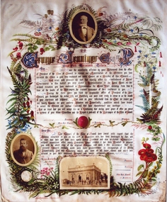
Photograph, Mr George Jennings -- Illuminated Address
... stawell shire president... presented by Stawell Shire Council. Included in the folder... for his serviced over many year to the council. stawell shire ...Illuminated Address for George Jennings "Mayo Park" Lubeck. The top photo is of George Jennings, The other portrait is of Alfred Clemes. The illumination was given to George Jennings for his serviced over many year to the council. Enlarged colour photograph of an illuminated address presented by Stawell Shire Council. Included in the folder is a Black and white photograph also of the illumination in a brown folder. Included in the illumination are three photographs, two of males and one of a building with people. Floral decorations surround the writing and photographs. George Jennings Esq Mayo Park, Warranook Victoria stawell shire president -
 Stawell Historical Society Inc
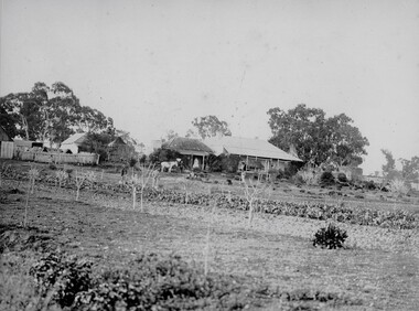
Photograph, "Allanvale" Home Station in Great Western 1866
... of Photographs by Mr. O.G. Armstrong as commissioned by the Shire... by Mr. O.G. Armstrong as commissioned by the Shire of Stawell ...Allanvale Home Station. Part of a collection of Photographs by Mr. O.G. Armstrong as commissioned by the Shire of Stawell for the Inter-colonial and Paris Exhibition in Melbourne in 1866. Allanvale was taken up about 1841 by John Allen, who was the son of George Allan of Allanvale, near Launceston in Van Diemen's Land. He selected 80,000 acres between present day Stawell and Ararat. The property was gradually reduced in size, with the first split occurring in the 1840s with the annexation of Concongella Selection due to a land dispute. J.S. Davidson was the occupier of Allanvale at the time this photograph was taken. The homestead pictured here was destroyed by fire at the end of the First World War and replaced by a new building around 1923. The present owners of Allanvale are the Kilpatrick family A note on the Allan family. On the 15th of March 1845, John Allen's 26 year old wife died at the birth of their third child, a daughter, who also died several weeks later. Elizabeth Allen had been a dear friend of Mrs Horatio Wills of neighbouring Lexington station. Eliza and her daughter were buried side by side in the garden of Lexington homestead. She was said to have been the first white woman to have died in the district. Homestead and stables on left with people on verandah and orchard in foreground.stawell great western -
 Stawell Historical Society Inc
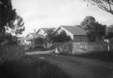
Photograph, “Overdale” Homestead in Concongella
... on the Stawell Shire Council for over 100 years.... on the Stawell Shire Council for over 100 years. stawell Overdale sign ...“Overdale” Holden Homestead Concongella. James Holden settled on "Overdale" in the late 1860's. The Holden Family still live at "Overdale" The Holden Family have served on the Stawell Shire Council for over 100 years.Black and White enlarged photograph of house in file and small original photo in album. Building has prominent stone wall and trees around the house which has an inner timber and wire fence. Overdale sign on the stone wall.stawell -
Stawell Historical Society Inc
Instrument - Realia, Engineering Instruments from Northern Grampians Shire
... label on the inside "Shire of Stawell". Also had paper... label on the inside "Shire of Stawell". Also had paper ...1: Small cardboard box with lid containing Silver distance Measurer. This was used for Measuring distances on plans.(Planimeter) 2: Cardboard Box without lid containing three plumbobs: One large turned brass: one small turned metal. One circular silver coloured metal complete with string and winding board. These were used to locate survey equipment above a fixed point. 3: Timber ( Vic Ash?) dovetailed box with brass hinged lid and brass swing catches containing plywood templates called railway curves, used for drawing curves on plans. 4: Cardboard box with lid containing Allbrit panimeter in Bakelite/plastic box with silver metal hinges and catches "Shire of Kara Kara" inscribed on the box. The box contains the original Instructions. The Planimeter was used for calculating areas of Irregular shapes and used for estimating quantities from plans of cut and fill projects, as one example. 5: Timber Box with brass hinges and swing catches wand leather carry Strap containing one set of self adjusting level made by E.R. Watts and Son, London England. Paper label on the inside "Shire of Stawell". Also had paper instructions pasted to the inner lid. The level was used for taking Ground Levels. The first 3 have been in use up until the 1990's, when computer drafting took over the role of these instruments with greater speed and accuracy. The dumpy level would have been superseded in the 1980's when automatic levels became cheaper, and were more accurate. stawell -
 Stawell Historical Society Inc
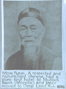
Photograph, Mr Mow Fung from Deep Lead -- Studio Portrait
... of the Stawell Shire. by Robert Kingston. ... of the Stawell Shire. by Robert Kingston. stawell chinese mullock bank ...Portrait of Mow Fung Deep Lead plus Grave Headstone. In the twentieth Century the Chinese population around Stawell continued to dwindle. One family whose associations with the area was the Mow Fungs. refer Page 117 "Good Country for a Grant" A History of the Stawell Shire. by Robert Kingston. A photograph of a male Chinese with a beard and dressed with a skull cap. The photograph has a blush tint.Mow. Fung... A respected and naturalized Chinese had a store and hotel at Mullock Bank (Morella) and later moved to Deep Lead. Photo 1896stawell chinese mullock bank morella -
 Stawell Historical Society Inc
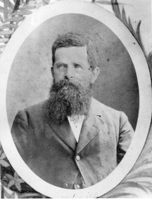
Photograph, Mr Alfred Clemes -- Studio Portrait
... Country for a Grant" A History of Stawell Shire by Robert Kingston. ... Country for a Grant" A History of Stawell Shire by Robert Kingston ...Portrait of Alfred Clemes. Chemist then Shire Secretary. Alfred Clemes was a Shire Secretary from 1871-1915. He was born at Austell, Cornwell in 1829. Clemes arrived in Pleasant Creek in 1858 where he set up a business as a chemist. Ref p.91 "Good Country for a Grant" A History of Stawell Shire by Robert Kingston. Black and white photograph of a bust of a male, with full beard - white shirt, dark buttoned coat. Setting oval with design in corners. Mounted in brown folder.Hand written on back of folder Mr. Clemes Secretarystawell -
 Emerald Museum & Nobelius Heritage Park
Administrative record - Nobelius Nursery Cash book, October 1903- December 1910, 16/10/1903 - 18/12/1910
... ); Cremorne Nursery (p. ......., 94); Stawell Shire Council (p. 95...); Cremorne Nursery (p. ......., 94); Stawell Shire Council (p. 95 ...The Cash Accounts contain the names and transaction details of all Gembrook Nursery clients. As well as private individuals, clients also included the following: Fitzroy City Council (p.2, 23, 41, 58. 93); Collingwood Council (p.2, 11, 54, 62, 71, 93); Lands Dept (p.2,5, 28, 30, 45, 61, 73); Melbourne Water Supply (p. 2); Victorian Railways (p.4, 6, 7,17,19, 20, 21, 22, 23, 24, 25, 27, 29, 31, 32, 33, 35, 37, 47......); Salvation Army (p.5, 36, 72, 94); Hawthorn Council (p.11, 37, 57, 69); Kew Council (p.12, 34, 55); Caulfied Shire Council (p.14, 35, 37,53, 69, 90, 93, 108); City of Melbourne (p. 26, 54, 96); Narre Warren Library (p. 44)., Public Works Dept (p. 55); Nunawading Shire Council (p. 70); Prahran Shire Council (p. 91, 102, 108); Dept of Agriculture N.Z.(p. 93); Hawkesbury Ag College (p. 93); Cremorne Nursery (p. ......., 94); Stawell Shire Council (p. 95); Monbulk Jam Factory (p. 100, Euroa shire Council (p. 108))The accounts also track Nobelius' travel expenses.The cash account books are historically, and socially significant as the entries give an insight into the growth of the company and the details payments from local and other government offices and overseas customers as well as significant companies associations and people. The earlier account books also detail wage payments.Hard cover cash book, brown leather binding, black cover, pink marbled end paper, book has 239 pages all used, date starts 16th October 1903 and ends 18th December 1910. c. a. nobelius & sons, gembrook nurseries, horticulture, accounting, emerald -
 Emerald Museum & Nobelius Heritage Park
Administrative record - Nobelius Nursery Cash Book, 1895-1908, 21 August 1895 - 12 October 1903
... ); Cremorne Nursery (p. ......., 94); Stawell Shire Council (p. 95...); Cremorne Nursery (p. ......., 94); Stawell Shire Council (p. 95 ...The Cash Accounts contain the names and transaction details of all Gembrook Nursery clients. As well as private individuals, clients also included the following: Fitzroy City Council (p.2, 23, 41, 58. 93); Collingwood Council (p.2, 11, 54, 62, 71, 93); Lands Dept (p.2,5, 28, 30, 45, 61, 73); Melbourne Water Supply (p. 2); Victorian Railways (p.4, 6, 7,17,19, 20, 21, 22, 23, 24, 25, 27, 29, 31, 32, 33, 35, 37, 47......); Salvation Army (p.5, 36, 72, 94); Boroondara Council (p.11, 37, 57, 69); Kew Council (p.12, 34, 55); Caulfied Shire Council (p.14, 35, 37,53, 69, 90, 93, 108); City of Melbourne (p. 26, 54, 96); Narre Warren Library (p. 44)., Public Works Dept (p. 55); Nunawading Shire Council (p. 70); Prahran Shire Council (p. 91, 102, 108); Dept of Agriculture N.Z.(p. 93); Hawkesbury Ag College (p. 93); Cremorne Nursery (p. ......., 94); Stawell Shire Council (p. 95); Monbulk Jam Factory (p. 100, Euroa shire Council (p. 108))The accounts also track Nobelius' travel expenses.The cash account books are historically, and socially significant as the entries give an insight into the growth of the company and the details payments from local and other government offices and overseas customers as well as significant companies associations and people. The earlier account books also detail wage payments.Hard cover cash book, with maroon embossed cover (alligator print cover), inner cover marbled front and back, cash book has a total of 139 pages all used, date starts 1895 and concludes in 1908c. a. nobelius & sons, gembrook nurseries, horticulture, accounting, emerald -
 Eltham District Historical Society Inc
Photograph, Fay Bridge, Rosehill Homestead, EDHS Heritage Excursion, 6 July 2019
July Excursion July 6, 2019 - Exploring Lower Plenty The predominant feature of this walk in the Bonds Road area, Lower Plenty is the large number of magnificent old River Red Gums that line the route. These trees are of the spreading woodland form of this species indicating that they must have been originally growing in a reasonably open setting. The walk also includes parts of the historic Cleveland Estate and the homestead “Rosehill” established by pioneer farmer Henry Stooke. This area was the site of the first recorded European settlement in what was to become the Shire of Eltham when the Willis brothers arrived in the late 1830s. From the southern part of Cleveland Avenue there are extensive views across and along the Yarra Valley. An article on the history of this area was contained in Newsletter edition 201, November 2011. The walk will start at the at the corner of Bonds and Stawell Roads, Lower Plenty - EDHS Newsletter No. 246 June 2019fay bridge collection, 2019-07-06, blackburn bricks, eltham district historical society, heritage excursion, rosehill homestead, lower plenty -
Glenelg Shire Council Cultural Collection
Photograph, A container full of housing components from Stawell being lowered into the old of the "Lady Caroline", n.d
Port of Portland Authority archives.Front: (no inscriptions) Back: (no inscriptions)port of portland -
Glenelg Shire Council Cultural Collection
Photograph, A container full of housing components from Stawell being lowered into the hold of the "Lady Caroline", n.d
Port of Portland Authority archives.Front: (no inscriptions) Back: (no inscriptions)port of portland -
Glenelg Shire Council Cultural Collection
Photograph, A container full of housing components from Stawell being lowered into the hold of the "Lady Caroline", n.d
Port of Portland Authority archives.Front: (no inscriptions) Back: (no inscriptions)port of portland -
 Halls Gap & Grampians Historical Society
Photograph - Coloured
The main building and chalets were built by E. C. Mitchell of Stawell. He was given a 99 year lease by the shire to build his holiday house at the site of Borough Huts. David and May Mitchell took over ownership of the house and chalets. The women in the photo are May and Isabel Mitchell and the man is David Mitchell. The chalets were called "Flappers Roost", "Bower of Innocence" and "Last Resort". The two copies of the photo are taken from slight closer in and are not as clear and do not show the entire third chalet.The photo shows a collection of old buildings. Two women are standing in front of a car and a man is standing a short distance from them. A second car is parked between the main building and the huts. The building to the far right of the photo is painted in a cream colour and has a tin chimney. The other buildings are three small huts or chalets. Gum trees and a mountain range can be seen directly behind the buildings.buildings, houses -
Federation University Historical Collection
Document, Zelda Martin, Central Victorian Goldmining towns - Boom Towns or Ghost Towns?, c1996
Zelda Martin was a PhD candidate at the University of Melbourne.[.1] 4th item in light blue display book titled Research Approach/Overview of Chapters/Confirmation of Canditure/Chapters1,2,3&4 of proposed thesis. *Twenty-seven page article on Victorian goldfields towns titled: Central Victorian Goldmining Towns - Boom Towns or Ghost Towns. The article was written during the author's PhD study. It outlines the context methodology, and resources and the chapters of the proposed thesis: (1) Central Victorian Goldmining Towns - The Context (2) Contemporary Views of the Factors Necessary for Town Growth (3) Outward Manifestations of Town Growth (4) The Trappings of Government (5-9) The Main Towns and Their Hinterland. [.2] 5th item in Light Blue display book as above item. *Chapter 1 of proposed thesis titled 'Pick, Shovel and Tin Dish Mining.' Covers in Section A: Central Victoria - Pre 1851: Aborigines in Central Victoria, Squatters, and Government. Section B: The years 1851-1854: The Early Gold Rushes, Government Reaction, Township Surveys, Legislation, Town Development, Local Government and Early Settlement. [.3] 6th item in Light Blue display book as above item. *2A of proposed thesis titled 'Contemporary Views of the Factors Necessary for Town Growth'. Similar information to Chapter 1 plus extra re towns and maps. Sections: Introduction, Context of Place - Geographical Towns Listed, The Context of Time - Pre1851 Aborigines, Governance of Port Phillip, The Squatters, The Villages of Central Victorian Highlands, Conclusion, Condensed Version of Chapter2B. [.4] 7th item in Light Blue display book as above item. *Chapter2B of proposed thesis. Sections: Area of Research, Schools, Banks, Newspapers, Progress Association, Town Development - Sandhurst (Bendigo), Ballarat, Castlemaine,, Maryborough, Ararat and Stawell. [.5] 8th item in Light Blue display book as above item. *Chapter 3 of proposed thesis titled 'Outward Manifestations of Town Growth'. Sections: Introduction, Contemporary Writing, Educationalists, The Bankers, The Townsfolk, Current Theory, General Theories of Urban Development, and Conclusion. [.6] 9th item in Light Blue display book as above item. *Chapter 4 of proposed thesis titled 'Trappings of Government' Sections: Introduction, Early Government Attitudes to Mining and Town Development, Law and Order, Township Surveys, Legislation, Local Government, Transport and Communication, The People and Lobbyists. [.7] 10th item in Light Blue display book as above item. *'The Rise and Fall of Central Victorian Goldmining Towns'. Includes a map showing main Goldfields, a table showing towns and villages at two points in time - 1857 and 1871; a Bibliography of Primary and Secondary Sources. [.8] Resource No1. Black display book titled Local Towns 1 : Alma: *Brief history *Directory *Maps Amphitheatre / Mountain Hut: *Brief History Post Office Directory Ararat: *Brief History *Post Office Directory 1869 - Alphabetical Listing by Occupation *Ararat - Prominent Citizens of 1858 *Langi-Morgala Museum Avoca: *Brief History *Excerpts from 'Avoca The Early Years', Margery and Betty Beavis; pg1 - Beginnings; pg11 - The Midas Touch; pg25 - Local Gold Escorts; pg27 - A Town is Born; pg51- The Administration of Justice; pg53 - The Ways of the Law; pg61 - News of the Day; pg65 - A Time to Play; pg72 - Land Ownership *Post Office Directory (Bailliere's) 1869 *Tourism Map and Information of area *Historic Avoca - A 5.5km Tour *Avoca & the Pyrenees Region - information pamphlet Ballarat: *Early History of Ballarat - Ballarat Historical Society, Publication No.1: origin of the name; Ballaarat - the Beginning; Fabulous Yields from the Ballaarat Goldfield; *Streetscape Lydiard Street. *Hand drawn map showing Leigh River, Old Portland Bay Road, plaque on road to Colac; etc. *Newspaper article re 'The Theatre Royal' ( which stood in the vicinity of the current Owen Williams store) - 'The News'15/04/1998 *Article - 'Ballarat's Mechanics' Institute Lives On' Ballarat Courier, 14/09/1985 *Article - Standing the Test of Time' The News 17/11/1993 re The Mechanics Institute & picture of the Reading Room *'Ballarat a Study of a City, Phyllis Reichl, pub. Nelson, 1968; no.3 place, time and people field studies series *Investigator Vol.33 No.2, 1998 Geelong Historical Society. Article on pg75 describes Ballarat in 1861 *Folded poster - 'Ballarat 100' a history of telegraph communication, pub. Telecom. Beaufort (Fiery Creek): *Brief history *Post Office Directory [.9] Resource No.2 Black Folder Titled Towns cont.No2 Bendigo (Sandhurst): *'Family & Local History at the Bendigo Library - 1851-2001 150 years of gold'. *Bendigo Government Camp in 1853 illustration; key to sketch and names of Government officers stationed there *Excerpts from 'Bendigo and Vicinity' Adolph Haman *The Bendigo Goldfield Registry - pgs 1-7 Introduction *Excerpt: 'Breaking the Grip' *Excerpt: The Most Go-Ahead Place *Excerpts from 'History of Bendigo' - anti license agitation; laying out of town; proposed railway; gold calls and dividends; the Sandhurst Municipality; journalism *Bibliography Blackwood: *Excerpts from 'Aspects of Early Blackwood - The Goldfield, the Landmarks, the Pioneers' Alan J Buckingham and Margaret F Hitchcock, JG Publishing,1980 Buninyong: *A Brief History *Investigator Vol1 No.2 Feb 1966 Geelong Historical Society. Pg3 - Article re gold escort route - Mt Alexander to Adelaide - (see a simple monument on the Western Highway a few miles out of Horsham. Pg 15 - Ballarat Excursion - re the finding of gold. *Three articles published by Buninyong and District Historical Society Inc: (Magpie Exploration; Finding Gold In The Green Hills; Magpie Exploration; Burnt Bridge to Cargarie to Mt Mercer) *Copies of newspaper articles/items *Buninyong Street Directory Carisbrook: *In the Beginning There Was Carisbrook *The History of the Carisbrook Racecourse Carngham / Snake Valley: *Brief History *Directory Castlemaine: *Directory 1865-1866 - Alphabetical and Street *Poster - Castlemaine A Contemporary Guide "The Great Centre" 1866 - A Contemporary Guide to the Fascinating Past *Pamphlet - Castlemaine District Community Hospital *Map - Castlemaine, Maldon & Surrounding Districts *Map and Information - The Dry Diggings Track - a 55kl walk among historic goldfields relics ( Castlemaine Fryerstown Vaughan Mt Franklin Hepburn Daylesford) *Postcard - Former Court House *Directory 1867 - Alphabetical, Trade [.10] Resource No.3 Grey folder Titled Towns 3 Creswick to Maryborough Creswick: *Brief History *Booklet - "Creswick Cemetery Walk" *Booklet - The Buried Rivers of Gold Heritage Trail Creswick *Creswick Historical Museum Information Sheet *Chronological History of Creswick *Alphabetical Directory of the Borough of Creswick *Creswick's Creek Directory 1856 *Historic Creswick Walking Tour *A Brief Account of the Schools of Creswick - Past and Present *100 Years of Railway Travel in Creswick *The Berry Deep Leads *The Spence Home at Jackass Gully in the Creswick State Forest ( William Guthrie Spence - Pioneer) *The New Australian Mine and the 1882 Disaster *Creswick District News, Issue 7, July August 1999 *The Creswick Miners Walk - Information and Map *Maps Chewton: *Brief History *Directory Clunes: *Brief History *Clunes Street Directory Daylesford: *Brief History *Notable Bushfires in Daylesford District Over More Than a Century - "Black Thursday" 1851; 1862; 1899; the Disastrous Hepburn Fire of 1906; 1939; 1944; 1969. *Post Office Directory -Daylesford and Hepburn Dunolly / Inkerman: *Brief History *Directory *Pamphlet - Goldfields Historical Museum *Pamphlet - Historic Dunolly - Victoria's Best Kept Secret *Map of Gold Workings at Dunolly Area - showing where the main gold rushes occurred *Brief History - Inglewood *Directory - Inglewood - Name Occupation, Dwelling Kingower: *Brief History *Directory - Name / Ocupation / Dwelling Linton / Happy Valley / Piggoreet: *Brief History *Directory - Lintons McIvor: *"A History of the Shire and the Township of Heathcote" by J.O. Randell Majorca: *Brief History *Official Post Office Directory 1869 - Name / Occupation/ Address Maldon (Tarrangower): *Brief History Part 1 *Brief History Part 2 *Post Office Directory *List - Alphabetical Order by Names plus Business and Trade (Tarrangower Times Oct/1858) *List - Alphabetical Order by Trade plus Name and Business *Directory - Name / Occupation / Dwelling Maryborough: *Worsley Cottage - built by Arthur Worsley, a contractor in stonework in 1894 [.11] Resource No. 4 Blue Display Book titled Towns 4 Moliagul to Stawell Moliagul: *Brief History *Moligul Legislative Assembly (Voting?) List - Names and Occupations *Moliagul Victorian Post Office Directory 1868 - Name / Ocupation / Address / Comments *"The Welcome Stranger" gold nugget *The Sunday School *The Welcome Stranger Discovery Walk - information and map Moonambel (Mountain Creek) Redbank *Brief History *List of names extracted from advertisments of the Pioneer and Mountain Creek Advertiser 16/02/1861. *Bailliere's Directory 1869 - Alphabetical List of Name / Occupation / Place St Arnaud: *Brief History Sebastapol: *Brief History *Directory 1869 - Alphabetical by Name; plus occupation and address. Browns and Scarsdale: *Brief History *Browns Street Directory - Name and Occupation Smythesdale: *Brief Description *Smythesdale Street Directory -Name and Occupation Stawell (Pleasant Creek) *Brief History *Victorian Official Post Office Directory - Name /Occupation / Dwelling *Chronology - 1841-1920 *Production of gold statistics - 1879 - 1900 *Big Hill *Extracts from "The Golden Years of Stawell". Chapt 1 - Stawell's Coming Out. Capt. 2 - The Gold Rush. Caapt.3 - Cradle of Democracy. Chapt.4 - The Reefs Becomes Stawell. Chapt. 5 - Rushing In. Chapt.6 - The Pioneers. Chapt 7 - The Decade of Optimism. [.12] Resource No. 5: Blue Display Book titled 'Towns Steiglitz to the The Golden Triangle. Steiglitz: Brief History Victorian Post Office Directory 1869 *Map of Steiglitz *List of maps relevant to Steiglitz history *Information 6 tables of data from "Reports of Mining Surveyors Talbot (Back Creek) Brief History Taradale: Post office Directory 1869 - Name/Occupation/Street. Also list in alphabetical order by Occupation Taradale *Chronological Reference to Taradale Mines *Water - The Coliban System of Waterworks *Joseph Brady *The Syphon Tarnagulla (Sandy Creek) *Brief History *Tarnagulla Businessmen Cameos to give depth to advertisments in 'The Tarnagulla Courier' various issues 1864-1871 *Directory - Name/Occupation /Address *List - Name/Business/Trade Wedderburn (Koorong) *Brief History *List - Name/Occupation The Golden Triangle: *The Early Rushes - Wedderburn / Moliagul / Sandy Creek - Tarnagulla / Jones Creek - Waanyarra / Kingower / Dunolly - Goldsborough / Inglweood *Census of 1857 - Population / Occupations *1858-1871 - A Time of Consolidation- Wedderburn / Moliagul / Sandy Creek- Tarnagulla / Arnold *Census 1871 - Population *Information gleaned from the census data - Demographics / Population / Occupations / marital / Birthplace / Religion / Literacy/ Occupation and Housing Cameos *Graphs - Birthplace of settlers /Male-Female Ratio / Married males / Children under 15 as Percentage of Population / Religion *Census 1857 - Statistical data *Maps *Bibliography [.13] Resource No. 6 - Black Display Book Information and Research in Central Victoria including: *Banking - Research from ANZ Bank Archives *Institutions - also includes articles listed from the Ballarat Times Newspaper *Australian mining History Association - A.M.H.A. Bibliography *Australia's Mining History * Bibliography - Land Surveys Victoria - *1853 Administration (Statistics and Other) includes: schools / ministers of religion / police / military / local administration / licences for sale of spirits / distances between various Victorian gold fields. * Victoria Government Gazette (Copy) - N0. 116, 12/12/1854 includes: Gold Felds Commission of Enquiry & No. 85, 15/09/1854 - Addresses presented to the Lieutenant Governor (Sir Charles Hotham) during his tour through the Gold Fields of Victoria,1854. Addresses on behalf of : the people of Bendigo; Members of the Church of England, Bendigo; Members of the Wesleyan Church on the Bendigo Gold Fields; Bendigo Gold District General Hospital; the Bendigo Prospecting Association; Committee of the Bendigo Local Exhibition; Bendigo District Medical Association; Coloured Americans Resident at Bendigo; German Inhabitants of Bendigo; Landowners, Inhabitants, and Miners of Castlemaine; Inhabitants of Forest Creek; Inhabitants of Heathcote and Gold Miners of McIvor; Residents and landholders of the District of Bacchus Marsh; Inhabitants of Kilmore and Vicinity. *Gold Fields Correspondence 1853: letter from Lieutenant Colonel Valiant, (Officer commanding the Troops in Victoria) to the Lieutenant Governor re threatened disturbance at Sandhurst (Bendigo) regarding the Gold License Fee. * Extracts from a book "Victoria" re Gold Fields Commission of Enquiry involving mainly Ballarat and Castlemaine and a chapter titled 'A Tour to the Victorian Gold-Fields' *Lists of central Victorian newspapers - listed by date published 1851to 1874; by first date available to State Library. *A list of cities and towns showing County, population in 1861 &1871, and municipal status. [.14] Resource no.7. Black display book. *Reference: Papers presented to Parliament Victoria - 1859-1860 4 volumes - relevant sections copied. Contains information on Branches of Government. General / Finance / Gold / Gazette / Commission and Warrant / Statistic. *Gold Fields Act. In accordance with the Act the gold fields are divided into six districts - Ballaarat, Castlemaine , Sandhurst, Avoca, Ararat, and Beechworth.. Official staff in each gold district consists of a Resident Warden, Wardens, Wardens' Clerks, Bailiffs, Chinese Protectors, Chinese Interpreters, and Mining Surveyors. *Gold Receiver *Gaols *Police magistrates and Clerks of Petty Sessions, etc. *Field Branch *Immigration and Emigration Overland - Chinese - 1859 *Population on the Goldfields *The Geological Survey - The Government Geologist is assisited by staff from four branches - the office Branch; the Publishing Branch; the Field Branch and the Museum Branch. *Commission to Enquire Into Sludge dated 10/02/1859 (Some sections copied) - Report to the Honorable Chief Commissioner of Public Works, Melbourne re the mode of carrying the sludge from the puddling mills in Sandhurst without interfering with the drainage of the town and the roads in the neighbourhood. [.15] Resource No.8: Camel display book titled Resource No. 8. Aborigines *Lists of book titles - +"Readings in Victorian prehistory" +"The Aborigines of Port Phillip" +Aboriginal languages and clans" +"A History of the Port Phillip District" +"Langi Ghiran 1: Aboriginal Rock...." +"Koorie History: sources for aboriginal studies in the State Library of Victoria", ed. Tom Griffiths, Melb. Friends of the State Library, 1989 +"The Public Lands of Australia Felix"; settlement and land appraisal in Victoria1834-91 with special reference to the Western Plains", J.M.Powell, Melb. Oxford University Press 1970 +*Bibliography of the Victorian Aborigines' from the earliest manuscripts to 31st December 1970, Massoa, Aldo, Melb. Hawthorn Press, 1971 +"Aborigines in Colonial Victoria, 1836-1886", M.F. Christie, Sydney University Press, 1979 +"Urban and Industrial Australia: readings in Human Geography" ed J.M. Powell, Melb. Sorrett Pub. 1974 *Extracts: -Processes of Pioneer Settlement - The Squatting Occupation of Victoria, 1834-60. J.M. Powell -Areal Variations in the Class Structure of the Central-Place Hierarchy. P. Scott - Volume1 and Volume 2: Notes Relating to the Habits of the Natives of Other Parts of Australia and Tasmania. Compiled from various sources for the Government of Victoria by R Brough Smyth. John Curry, O'Neil, Melb. 1st pub. Melb. 1876. p31-45 - Numbers and Distribution of the Aborigines in Victoria -Victorian Aborigines 1835-1901 - A Resource Guide to the Holdings of the Public Record Office, Victoria; published by the Government Information Centre 1984. *History of the Aboriginal Artefacts Displayed in the Daylesford Museum. F. G. Powell (4 page pamphlet) *Letter to Zelda Martin from Peter Lovett, Cultural Officer, Ballarat & District Aboriginal Co- Operative, 05/02/1997 *Map: Ian Clarke Victorian Tribunal Boundary Map - Clans of Central Victoria. *Victorian Rock Art and Mythology - Article about Mount Langhi Ghiran and myths of the Tjapwarong people. *Two Aboriginal myths relating to the Grampians - 'The Monster Emu' / 'The Aquisition of Fire', by the Aborigines in the Grampians Areas *Article titled (chapter 8) Ballarat - information re camping sites in the region. Lake Wendouree / Lake Burrumbeet (includes a myth) / Mt Bunninyong / Lal Lal / Pitfield / Mount Elephant / Mount Egerton / Meredith / Lake Goldsmith / Lake Learmonth / Ercildoune *Notes on the Aborigines of the Wider Ballarat Region plus European names=Aboriginal names. John Morris 26/07/1995 *Role of Aborigines in Town Development in Central Victoria. Mentions Native Police Force est. in Port Phillip 1842 and Central Board for Aborigines est. 1860 *The Grave of King Billy. (Frank Wilson) Pamphlet. *Camping Places in Central and Northern Victoria. Article re Lake Burrumbeet site. *Programme for the Unveiling of Memorial Cairn for Edward Stone Parker 1802-1865. Note portrait not accurate. Accurate portrait is available in the book "A Successful Failure A Trilogy The Aborigines and Early Settlers", Edgar Morrison, Graffiti Publications, 2002. * Large envelope addressed to Mr G Netherway containing newspaper cuttings regarding the life of Edward Stone Parker, the unveiling of the Memorial Cairn as mentioned above, articles titled 'Episodes from Our Early Days' (Edgar Morrison, Yandoit)- The Black's School, A School At Last and The Final years. Also a typed page titled 'Historical Background to E.S.Parker's Career. Includes an interesting tale titled 'When the cat lay doggo' re laying power leads for the unveiling ceremony at the memorial site. [.16] green display folder titled 'Research Aids' *List of references to Commissioners' & W'ardens' Reports (formerly held at La Trobe Library Archives, now at Public Records Office [PRO]). Indicates town referred to / date of report / name of camp if different to town. * Archive information re Anglican Records *Movement around the Goldfields - Miners and Storekeepers - usefulness of newspapers in providing information - areas covered - Castlemaine, Maldon, Ararat, Stawell, Tarnagulla, Dunolly. *Port Phillip /Victoria Directories 1839/1867 - Chronological list of Directories included in this series. *"Notes on the History of Local Government in Victoria" A.W. Greig Melb. University Press 1925 - Photo-copied extract p5-p40. (Source - Deakin University Library) - Introduction by W.Harrison Moore. Section 1 - Development in New South Wales Before Separation. Section 2 - Development in Victoria After Its Separation from New South Wales. Hand written notations: 'roads, markets, and local government 1855 on' ;'opportunity of squatters in parliament' and 'opportunities of matters in parliament p33' * Notes on the Establishment of Surveyor General's Department 1851and Commissioner of Crown Lands and Survey. * Newspaper articles from The Argus, 1849, re the discovery of gold in the Pyrenees region. * Excerpt - a report on schools - A.B.Orlebar, Inspector; re the need for permanent school buildings rather than tents. *Excerpt from - 'Approaches to Urban History', Sean Glynn: The Case for Caution * Except from - 'The Urban Sprinkle', Weston Bate: Country Towns and Australian Regional History *Reference- 'The History of Land Tenure in the Colony of Victoria', John Quick. References the Haines Land Bill, land tenure and Land Leagues. [.17] Light blue envelope folder titled 'Birtchnell's Ballarat, etc. Directory 1862 *Contains various directories for Smythesdale, Buninyong, Clunes, Brown's and Creswick. [.18] Red envelope folder no.2 titled Victorian Gazetteer *Selected pages from 1869 Victorian Gazetteer on A4 paper (with a handwritten note questioning if some pages are from 1868 Victorian Gazetteer as appears to be different sizes - A3 pages.) Information includes locations and descriptions of towns, hotels, banks, communications and populations. (Does not include names, residences and occupations) [.19] Red Envelope folder titled Bailliere's Official Post Office Directory 1868 (or1869 or a mixture of both?) *Preface *Contains a selection of pages of towns highlighted in yellow in the the index *Work on this directory was commenced in 1867. *Information includes: Municipalities - mayors and councilors; lists of towns naming male inhabitants and their occupations. [.20]Yellow manila folder titled Post Grad Seminar Presentation 1996 *Gives some background to Zelda Martin's proposed thesis and why she chose the topic Gold Mining Towns Boom or Bust [.21] A3 display book - No. 1A * A list of 'Relevant Newspapers collected: The Tarrangower Times and Maldon Advertiser (first published 1858) Includes dates 1858-1867. The Mount Alexander Mail. Includes dates 1854-1866 The Tarnagulla Courier. Includes dates from1864-1871 Dunolly and Burnt Creek Express. Includes dates from 1862-1871 * Selection of newspaper pages from The Mount Alexander Mail 1854 to 1856, mostly showing advertisements for businesses and services provided to that community. [.22] A3 display book - No. 1B * Selection of newspaper pages from The Mount Alexander Mail 1857 to 1866, mostly showing advertisements for businesses and services provided to that community. [.23] A3 display book -No. 2 * Selection of newspaper pages from The Tarnagulla Courier 1864 to 1871, mostly showing advertisements for businesses and services provided to that community. [.24] A3 display book - No. 3 *Selection of newspaper pages from The Tarrangower Times (and Maldon and Newstead) Advertiser 1858 to1867, mostly showing advertisements for businesses and services provided to that community. [.25] A3 display book - No.4 * Selection of newspaper pages from The Dunolly and Burnt Creek Express; and The Dunolly and Betbetshire Express 1862 to 1871, mostly showing advertisements for businesses and services provided for that community. [.26] A3 display book - No.5 Includes: * Bryce Ross's Diggings Directory. Includes instructions for using this directory. This directory was used by "all persons having connexion or desiring to communicate with 'working parties, private friends, or Stores at the Diggings." As a directory for each area wwas completed it was published in each month's issue of Bonwick's "Digger's Magazine." Years c1852/1853. This Directory commences first at the head of Forest Creek. Includes a directory for Bendigo and Ballarat. Of interest at the end of the Bendigo and Ballarat directory is a list of the number of storekeepers, butchers, doctors, smiths, eating houses, lemonade sellers and chapels. * The Castlemaine Directory and Book of General Information Comprehending Glass's Model Calendar for the Two Years 1862 and1863. "zelda martin, victorian goldfield towns, bendigo, castlemaine, ballarat, maldon, stawell, ararat, maryborough, creswick, avoca, heathcote, banks, bank of australasia, union bank of australia, government camp, sandhurst, water supply, tarnagulla, talbot, back creek, mountain creek, police court, carisbrook, dunolly, thompson's foundry, charles clacy, anthony trollope, robert cecil, mount alexander, urbanisation, national schools, education, govenrment, industry, railway, transport, settlement, land settlement in central victoria, steiglitz, joseph brady, the new australian mine, berry deep leads, william guthrie spence, creswick state forest, arthur worsley, worsley cottage, the welcome stranger, moliagul, moonambel, redbank, st arnaud, sebastapol, brown's, scarsdale, clunes, chewton, daylesford, bushfires, inkerman, inglewood, kingower, lintons, happy valley, piggoreet, mcivor, majorca, tarrangower, taradale, the coliban system, the syphon, sandy creek, wedderburn, koorong, arnold, jones creek, waanyarra, the golden triangle, census 1857, blackwood, buninyong, durham lead, magpie, carngham, snake valley, alma, amherst, daisy hill, amphitheatre, mountain hut, beaufort, fiery creek, counties, population, gold fields commission of enquiry1854, william westgarth, gold license fee, lieutenant colonel valiant, administration of the victorian gold fields, commission to enquire into sludge 1859, e.s. parker, edward stone parker, edgar morrison, mount franklin protectorate, dja dja wurrung, memorial cairn, franklinford, mt franklin memorial cairn, jajowurrong, dja dja wurung, tjaowarong, wothowurong, assistant protectors, daylesford museum, buluk, rock art - grampians, aboriginal mythology - grampians, aborigines, first nations people, mount franklin, aboriginal artifacts, lake burrumbeet, native police force, central board of aborigines, yandoit, commissioners' reports, wardens' reports, port phillip/victoria directories 1839-1867, local government - victoria 1853/1854, surveyor general's department - 1850's, victorian schools 1850's, a.b.orlebar, haines land bill, william charles haines, wilson gray, land tenure, land leagues, victorian gazetteer, the tarrangower times and maldon advertiser - 1858-1867, the mount alexander mail 1854-1866, the tarnagulla courier 1864, dunolly and burnt creek express 1862-1871, bryce rose's diggings directory, the castlemaine directory 1862-1863 -
 Federation University Historical Collection
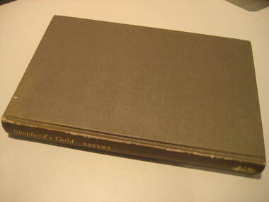
Book, C.E. Sayers, Shepherd's Gold: The Story of Stawell, 1966 (exact)
One of the 6 University of Ballarat campuses is at Stawell.Grey hard covered book of 194 pages covering the history of Stawell, Victoria. Contents include Gold, squatters, Ayreys of Warranooke, Diggings, Reefs, Local Government, Road District, Shire, Borough, Town, Hospital, schools, Churches, Growth of Settlement, Claim Jumps, Sheep, Farming, Water, Grampians, Magdala, Callawadda, Deap Lead, Glenorchi, Great Western, Green's Creek, Marnoo, Wal Wal.education, religion, stawell victoria, stawell -
 Stawell RSL Sub Branch War Museum
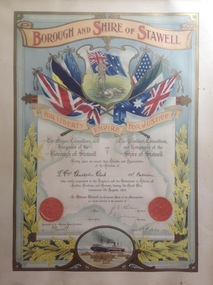
Certificate of Appreciation from Stawell Borough and Shire for WW1 soldier Christopher Clark, Certificate of Appreciation, Approx 1916
... Certificate of Appreciation from Stawell Borough and Shire... the First World War started he came back to Stawell and enlisted ...Soldier in WW1 Australian Imperial Expeditionary Force No 5998 Christopher Clark 59th Battalion Born in StawellChristopher was a WW1 Serviceman from Stawell Framed Certificate of Appreciation for Soldier No 5998 Christopher Clark Australian Imperial Expeditionary Force WW1, 59th Battalion Christopher Clark was born in Stawell on 25th December 1892 and was brought up on the family farm in Callawdda and worked in the district and then in Queensland where he obtained an engine drivers licence and drove the sugar trains then worked on the steam boiler engines in the sugar mills. When the First World War started he came back to Stawell and enlisted in the army on 11/4/1916. He was sent to France in the 59th Battalion. He was in the army 1175 days, serving 1029 days abroad. During his service he was promoted to Lance Corporal. Details from his daughter Ruth Clark of Ararat December 2017. Soldier No 5998 Christopher Clark Australian Imperial Expeditionary Force WW1 59th Battalion Born in Stawellww1, serviceman, soldiers, military, stawell