Showing 384 items matching "spurs"
-
 Bendigo Military Museum
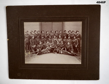
Photograph - PHOTOGRAPH OF A GROUP OF SOLDIERS, Australian Army, c1916 - 1918
These are WW1 Australian soldiers, They have leather bandoliers, leather leggings and spurs. Most have slouch hats. Therefore they are probably drivers. The big officer in the middle has red tabs so it is assumed he would be Colonel or above. Seated on the ground, right side is a veteran. He has a colour patch with the letter "A" . There is a Lance Corporal with a colour patch. I would place this as c1916-1918.This is a small group portrait set into a cardboard frame. The photo is black and white. There are 3 ranks of soldiers in front of a timber weatherboard building.On the back written in texta is Mrs O. Pell.photograph, ww1 -
 Bendigo Historical Society Inc.
Document - RESEARCH PAPERS: HISTORY OF BENDIGO SALEYARDS, 1869
In 1859 6 acres were set aside for use as a cattle market and this was established between January and July 1861 in Charleston Road, Bendigo. By 1889 this had expanded to 13 acres. It initially included an abattoir, butchers, tanners and soap makers. In 1893 a rail spur was opened to prevent the need to drive cattle through residential areas. The yards moved to their current site at Huntly in 1997.HISTORY OF BENDIGO SALEYARDSbendigo saleyards, cattle market -
 Falls Creek Historical Society
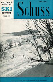
Journal - Schuss Vol. 23. No. 4 June 1957
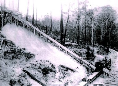
Schuss was advertised as Victoria’s Official Ski Journal It was issued monthly from 1935 to 1961 except during the war when summer issues covered two months. This continued after the war, but it averaged 10 issues annually over its 25 year life. Schuss was published by the Ski Club of Victoria which had a membership of 38 Ski Clubs and demanded to be recognised as the prime authority on skiing in the state. The other 30 ski clubs with 85% of the members disagreed and the politics of skiing became heated. These clubs formed the Federation of Victorian Ski Clubs with their own journal, Ski Horizon. With the establishment of the Victorian Ski Association, Ski-Horizon published its last issue in Nov - Dec. 1955 and the role of the official journal was fully taken over by “Schuss”. This item is significant because it contains stories, images and information documenting the development of the ski industry in Victoria.The journal features stories and events chronicling developments in Victoria and internationally. This issue features a photo of skiers on the Frying Pan Spur Slopes by R. D. McNabb. Page 128 includes a brief article relating the successful recruiting of ski instructors at Bonegilla Migrant Reception and Training Centre. Page 134 has a photo of a skier at the Cornice, Frying Pan Spur near the Nissen Tow, Falls Creek taken by R. D. McNabb in November 1956. Spion Kopje is in the background. Page 138 "Skimming Around Falls Creek" gives a progress report on developments at Falls Creek. This includes an update regarding Bob Hymans' chair lift and new snow vehicles, Milan Kovacic's new "Snow Crystal Inn", a new Coffee Lounge at the Falls Creek General Store operated by "Cecil and Orest" and other work and maintenance carried out for the 1957 Winter season.schuss journal, the ski club of victoria, bob hymans, snow crystal inn, cecil dobson, ory freauf -
![Giant fern trees: Splitters' Track, Black Spur / [by] Nicholas Caire, circa 1876](/media/collectors/550653872162f11fb04854aa/items/57774978d0cdd10a5c123cdb/item-media/57774a0fd0cdd10a5c1297aa/item-fit-380x285.jpg) Kew Historical Society Inc
Kew Historical Society IncPhotograph, Anglo-Australasian Photographic Company, Giant fern trees: Splitters' Track, Black Spur, c. 1876
Nicholas Caire was born on Guernsey in the Channel Islands in 1837. He arrived in Adelaide with his parents in about 1860. In 1867, following photographic journeys in Gippsland, he opened a studio in Adelaide. From 1870 to 1876 he lived and worked in Talbot in Central Victoria. In 1876 he purchased T. F. Chuck's studios in the Royal Arcade Melbourne. In 1885, following the introduction of dry plate photography, he began a series of landscape series, which were commercially successful. As a photographer, he travelled extensively through Victoria, photographing places few of his contemporaries had previously seen. He died in 1918. Reference: Jack Cato, 'Caire, Nicholas John (1837–1918)', Australian Dictionary of Biography.An original, rare photograph from the series 'Views of Victoria: General Series' by the photographer, Nicholas Caire (1837-1918). The series of 60 photographs that comprise the series was issued c. 1876 and reinforced a neo-Romantic view of the Australian landscape to which a growing nationalist movement would respond. Nicholas Caire was active as a photographer in Australia from 1858 until his death in 1918. His vision of the Australian bush and pioneer life had a counterpart in the works of Henry Lawson and other nationalist poets, authors and painters.Albumen silver photograph mounted on boardprinted in ink on support l.c.: GIANT FERN TREES: SPLITTERS' TRACK, BLACK SPUR. / COPYRIGHT REGISTERED. printed in ink (vertically) on support reverse u.c.l.: J.W. FORBES, Agent, printed in ink (vertically) on support reverse c.l.: ANGLO-AUSTRALASIAN PHOTOGRAPHIC COMPANY, MELBOURNE. printed in ink (vertically) on support reverse c.: VIEWS OF VICTORIA. / (GENERAL SERIES.) / No. 8. / GIANT FERN TREES: SPLITTERS' TRACK, BLACK SPUR. / The scene which this illustration represents is situated on Morley's Creek, at the foot of the Black Spur, and is / about a mile and a half from the Township of Fernshawe. The Fern Trees in this locality are of gigantic growth, / measuring 50 feet in height, the fronds of which are from 12 to 15 feet long. This excessive growth is attributable / to the great number of springs flowing into the creek, thereby causing the surrounding soil to be in a continual / state of moisture. printed in ink (vertically) on support reverse l.c.l.: 10 Temple Court, Collins Street West.landscape photography, nicholas caire, black spur - victoria -
 Falls Creek Historical Society
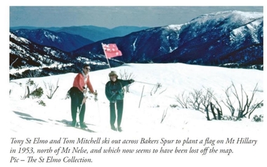
Photograph - Tom Mitchell and Toni St. Elmo plant flag at Mt. Hillary
Tom Mitchell was a strong supporter of trans-Tasman ski competitions and in the early 1950s visits between local clubs became common. In 1953 a team from New Zealand visited Falls Creek for the first time. This was only a few months after Edmund Hillary and Nepalese Sherpa Tenzig Norgay became the first climbers confirmed to have reached the summit of Mount Everest. Toni St. Elmo, supported by Tom Mitchell proposed that a peak on the Bogong High Plains northwest of Mt. Nelse should be named Mt. Hillary in honour of the New Zealander's success. He also suggested a ceremony should be held during the visit of members of the New Zealand Ski team to Australia in September 1953. This image from the St. Elimo Collection held by the Falls Creek Historical Society, represents the planting of a New Zealand flag on the mountain during the ceremony.This image is significant because it is part of the St. Elmo Collection which documents early pioneers of Falls Creek and their outstanding contribution to skiing in Australia.A coloured image of two skiers carrying a New Zealand flag across the High Plains.Beneath the image: Tony St Elmo and Tom Mitchell ski out across Bakers Spur to plant a flag on Mt Hillary in 1953, north of Mt Nelse, and which now seems to have been lost off the map. Pic - The St Elmo Collection.tom mitchell, st. elmo collection, toni st. elmo, sir edmund hillary -
 Bendigo Historical Society Inc.
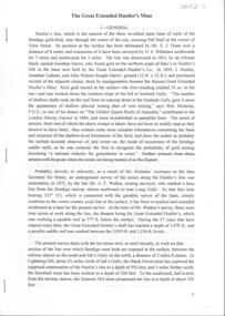
Document - Great Extended Hustlers Gold Mine, Albert Richardson
Seven men were killed at the Great Extended Hustler's mine disaster on 2nd May 1914 by an explosion of dynamite occurring as the men were waiting at the plat to ascend the mine at the end of their shift. No blame was attached to anyone in the findings of the inquisition. It was unknown what caused the dynamite to explode. This document formed part of the research done at the time by Bendigo Historical Society, of the 100 years commemoration of the mine disaster, held at Hustlers Hill in 2014. Six page copy of research document, describing the history and geology of the Great Extended Hustlers Mine and the Great Extended Hustlers Reef Q.M. Co.. Topics include: general overview of history, mines along the Hustlers line, characters of the saddle reefs, gold occurrences, effect of pitch, influence of faulting, payable reefs and saddle reefs and spurs. Mine overview researched by Mr. Albert Richardson. great extended hustlers, goldmining, hustlers consols, united hustlers and redan, k.k. mine, comet, hustlers reef no. 1, hustlers reef, hustlers royal reserve co., park shaft, hustlers royal reserve no. 2, city shaft, fortuna hustlers -
 Bendigo Historical Society Inc.
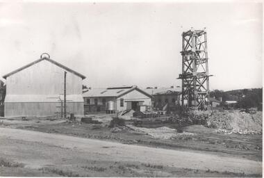
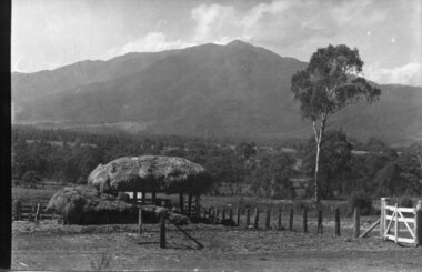
Photograph - Nell Gwynne Mine Site, 1934
Nell Gwynne (B.M.L.) Mine Manager's Report 12th January 1935: Main Shaft - advanced 35 ft to 147 ft below collar and timbered to 131 ft. Progress through W. dipping bed with quartz spurs between 120 and 125 ft. Erection of 1000 cfm compressor unit nearing completion. Sinking winch foundations being placed. (Sun News Pictorial, 12th January 1935) Significant to mining history of Bendigo.Black and white photograph of Nell Gwynne mine site. Image shows three sheds on mine site, metal headframe with four levels constructed in front of sheds and over the shaft. Written in pencil on back of photograph in black pen: 'Nell Gwynne '5/2/35'nell gwynne gold mine, shaft, mining, gold mining -
 Bendigo Historical Society Inc.
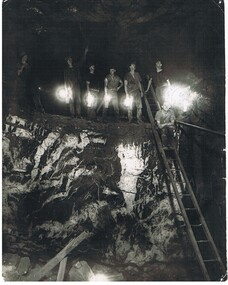
Photograph - HERCULES AND ENERGETIC MINE, 1939
black and white photo of underground mining, showing 8 miners in a stope with their Bendigo bucket carbide lights. A large quartz spur formation is visible in the foreground. A wooden ladder gives a good scale in relation to the stope size. Photograph taken in the Central Nell Gwynne at the 265 m. level C 1939. On back MNc4 ( in indian ink ) ? Hercules and Energetic ( in ball point pen ) RHSV of Vic. Stamp.organization, business, hercules and energetic mine -
 Otway Districts Historical Society
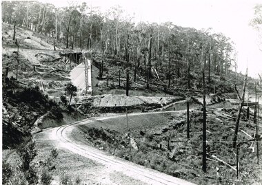
Photograph, Brucker, Pile Siding: horse-drawn timber tram, c.1920, c.1920
Pile Siding was opened in December 1915 because of the Pettit Brothers sawmill and pile extraction operation. The siding was a spur with points facing Beech Forest with a timber tramway feeding the siding. During 1916/17 Pettit's sent away 5,000 tonnes of timber before moving to another site, after which loading dropped to insignificant proportions. Pettit's again occupied the site from 1924 and traffic rose to major levels again.B/W. A six horse-drawn timber tram at Pile Siding station in c.1920. Two timber workers are seated at the centre. Stacks of timber are awaiting collection. Note the bare tree trunks in the background. pile siding; weeaproinah; railways; tramways; -
 Bendigo Historical Society Inc.
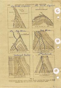
Document - REEFS AND SPURS ON BENDIGO GOLDFIELD
Three pages of information (copied ) regarding reefs and spurs on Bendigo Goldfield. Page 1020 'Geology of Australian ore deposits', drawings labelled in blue biro: No 19 level Virginia Mine, No 6 level South Virginia; No 9 level, Big blue, Big Blue, Deborah Cons'ted ( consolidated?) North Deborah. On bottom ' cross sections through various saddle reefs, showing the range of shape possible, and the association with monchiquite dykes' Page 1021 ( cont) Virginia South Extended; 3000ft New Chum Rly; Catherine Reef, Spurs in Carlisle. On bottom ' Cross sections through a trough reef, 'double' saddle reef and spurry systems. Final page: mines listed and descriptions of workings: Golden Age, Johnson's Reef Extended, Golden Pyke, Constellation, Great Northern, Virginia, Specimen Hill United, New Argus, Clarence United, North Argus, South New Moon.bendigo, mining, reefs and spurs -
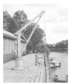 Wodonga & District Historical Society Inc
Photograph - The River Port of Red Bank
THE RIVER PORT OF REDBANK During the 1870s, Red Bank would have been one of the busiest ports on the Murray River. When the railway line was being built from Melbourne to Wodonga all the railway material was brought up river from Echuca by paddle steamer and barge and unloaded at Red Bank. The material was loaded onto horse teams or bullock wagons and taken along the route of the spur line. During the 187 MacCulloch & Co. handled 3000 tons of railway material here' The port was operational from approximately 1870 until 1874. THE FIG TREES The fig trees and a small bank of gravel are the only visible reminders of where the spur line from the wharf at Red Bank met the main line. It was at this point that all the material for the mainline was transferred from the small locomotives and wagons from Red Bank. It would have been carried by bullock wagons and horse teams and unloaded at different places as the line progressed. After the line was completed in 1873 the fettlers from Wodonga would patrol this length of the line.These images are significant because they document an important stage in the development of transportation in North East Victoria.Images of the River Port of Red bank near Wodonga on the Murray River. 1. The wharf 2. All that remainsred bank port, historic wharf wodonga, river transport -
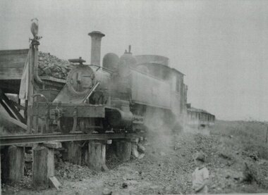 Otway Districts Historical Society
Photograph, Beech Forest: NA locomotive taking coal, c.1955
To a dead end spur at Beech Forest station a locomotive depot was provided with a coal stage, ash pit and water tank as part of the original facilities of the station. Coal was transported from Colac by rail and hand-shovelled up onto the stage from an NQ truck positioned alongside. Twin water columns on the stage ends enabled two NA class or both ends of a Garratt locomotive to take water simultaneously. Beneath the trestle was the ash pit.B/W. 200mm x 271mm. An NA locomotive on trestles taking coal at Beech Forest. A child watches.beech forest; railways; coal stage; na locomotive; -
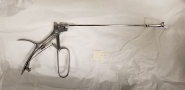 Royal Australian and New Zealand College of Obstetricians & Gynaecologists (RANZCOG)
Equipment - Cervical punch biopsy forceps
Used to take a sample from the cervix as part of a cervical biopsy. 'Rostfrei' is a German word meaning 'rust free', which is an equivalent term for stainless steel.Stainless steel cervical punch. Consists of a long, thin metal shaft, extending out in a perpendicular fashion from the handle. There is a small cutting tooth at the end of the shaft. Handle consists of an oval shaped trigger attached to a solid metal handle. A curved metal spur extends from the back of the handle to provide purchase for thumb grip. Overall shape of the instrument resembles a handgun in style. Inscription on handle of instrument reads 'ROSTFREI'. obstetrics -
 Otway Districts Historical Society
Photograph, Victorian Railways, Gellibrand Ballast Siding, c.1902, c.1902
In 1902 a ballast siding was opened 4km south of Gellibrand to provide materials for track construction. A spur siding, with points facing Beech Forest and a capacity for six trucks, was cut into the side of a slope. Above this was erected a loading bin and chute. The stone proved to be of durable quality so the siding continued in commission after 1902 for track re-ballasting work. By the mid-1920s Victorian Railways found it more economic to use ballast from Penshurst, so the siding was closed by 1925 and the rails lifted.Photograph; B/W. Gellibrand Ballast Loading Sitegellibrand; ballast; railways; siding; -
 Kiewa Valley Historical Society
Roper's Hut Memorabilia
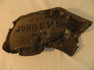
Roper's Hut was built in 1939 and was burnt down in 2003. It was rebuilt in 2008 and is situated on the Bogong High Plains on Duane Spur (where Duane's hut had been before it too was destroyed by (1939) bushfires, between Mt Nelse and Big River. The original hut was used as a shelter for cattlemen who grazed their cattle on the High Plains during summer. The Victorian High Country Huts Association Inc. members and friends helped rebuild the hut which is now used as an emergency shelter for visitors to the High Plains.The memorabilia is significant as the items belonged to the Roper family who were one of the original settlers of the Kiewa Valley and one of the original families who drove their cattle up to the Bogong High Plains. The burnt plaque and forks and the rebuilding of the huts (Duane's & Roper's) are significant as bush fires are a constant threat to the Bogong High Plains destroying large areas at a time.1. Bronze Plaque and 2 damaged forks from Roper's Hut which was destroyed by bush fires in 2003. 2. DVD & USB and hard copy photos of the rebuild of Roper's Hut in January 2008.The plaque had 'In Memory of / John F. P. Roper/ died 3-12-1977 / Aged 78 years / He built the original hut Feb. 1939'roper's hut, cattlemen, bogong high plains, bronze plaque, roper family, bush fires -
 Kiewa Valley Historical Society
Photo - Cleve Cole
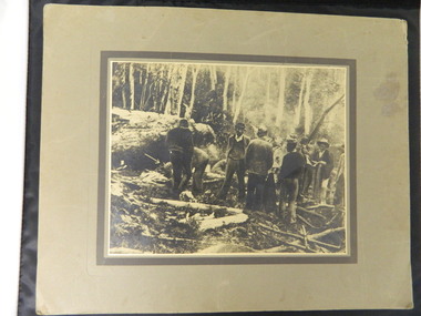
This photo depicts the rescue of three local skiets that became trapped on Mt Bogong during a blizzard and became known as the Cleve Cole tragedy . Mick Hull Howard Michell and Cleve Cole where skiing on Mt Bogong and could not find their way off the mountain via Staircase Spur due to Blizzard conditions and ended up in the Mitta Valley. Howard Michell walked to the Battys farm to get help for his weak and injured friends. Cleve Cole died shortly after arriving at Omeo hospital. This photo is historically significant as it tells the rescue story of this tragedy. The photos are of the people involved which add to the story. Mt Bogong Victoria's highest mountain is accessed from the Kiewa Valley and near by high plains and over shadows Mt Beauty township therefore is a local story. The photo comes from the rescue party which is a rare photo and thus has great interpretive capacity . The skiing history is one of KVHS main themes and this photo is part of our Skiing Across Country exhibitionBlack and white photo of several men in the bush near Mt Bogong. Photo is glued on to cardboard with a dark grey border and light grey wider border on the outside.Handwritten on back "The Discovery of Cleve Cole / up the Big River (Below Paddy's Flat) / Cole is arrowed / Cyril Rootsey / Jack Batty / Bill Batty / Paul? Bitner / Tom Fitzgerald / Etc. / (I think dad is the one with his hand up to his face)" Back - red stamp - "Herald Feature / Service / Melbournecleve cole. mt bogong. big river. paddy's flat. -
 Federation University Historical Collection
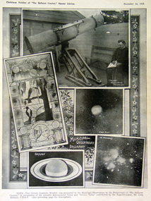
Photograph, Ballarat Observatory, c1915
In 1884 the Ballarat School of Mines Council reserved a three acre site on a spur of the White horse Ranges known as Mount Pleasant. The Vice-President of the Ballarat School of Mines, James Oddie undertook at his own expense (said to be 4,000 pounds) to erect and equip the observatory. By 1886 seven rooms, a workshop and a cottage had been erected. The first large telescope built in Australia, the Baker Telescope, opened 1888. In 1913 the Council of the Ballarat School of Mines handed over the Observatory to the Ballarat East Town Council. A number of images as depicted in a newspaper. The top image shows the Carlver Equitorial Telescope. Middle left is a stained glass window at the observatory (donated by the Ballarat Courier), middle right is 'fire mist'; lower left shows Saturn, and lower right is 'in pleiades'.ballarat observatory, telescope, stained glass window, jelbart telescope, equalateral telescope, meterological apparatus, john brittain -
 Bendigo Historical Society Inc.
Map - K. K. MINE - TRANSVERSE SECTION K. K. MINE
Transverse Section of the K. K. Mine on the Hustler's Line of Reefs, Bulletin No 33, Plate No XXXII. Map shows the different levels and their depth. Also, the different types of stone encountered and geological features such as spurs and faults. Has drawing of the poppet legs at the top of the shaft and sill of shaft 773.56 ft above sea level. Map has Geological Survey of Victoria crest and signed by H S Whitelaw, Underground Survey Office Bendigo, September 1913. miners, fortuna hustler's mine, transverse section of k. k. mine, hustler's line of reefs, geological survey of victoria, h s whitelaw -
 Kiewa Valley Historical Society
Photograph - Mt Bogong - Tawonga, 06/05/1937
Mount Bogong located in the Alpine National Park and part of the Victorian Alps of the Great Dividing Range, is the highest mountain in Victoria, Australia, at 1,986 metres (6,516 ft) above sea level. The Big River separates the massif of the mountain from the Bogong High Plains to the south. From the nearby town of Mount Beauty to its summit, Mount Bogong rises more than 1,600 metres (5,200 ft), thus making it one of the highest peaks in Australia not only in terms of its elevation above sea level, but also in terms of actual base-to-summit prominence. Mount Bogong is a popular backcountry skiing mountain through winter but only has snow for the mid winter-spring months. It is around 30 kilometres (19 mi) by road and walking track or 12 kilometres (7.5 mi) direct to Mount Beauty. Falls Creek and Mount Hotham ski resorts are also nearby. Camping is relatively safe below the tree line but the summit ridgeline is very exposed. Emergency shelter is also available at Bivouac Hut on the Staircase Spur, and at Cleve Cole, above Camp Creek on the broad ridge to the south of the summit, and Michells Hut on the Eskdale Spur. Mt Bogong is a popular recreational venue in the Kiewa Valley for back country skiing and bush walking and is a favourite with sightseers and popular subject for photographersBlack and white photograph of Mt bogong taken from Tawonga - Thursday May 6th, 1937Handwritten on back of photograph. Thursday May 6th, 1937. Mt Bogong Tawongamt bogong, tawonga, kiewa valley -
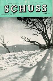 Falls Creek Historical Society
Journal - Schuss Vol. 21. No. 2 March - April 1955
Schuss was advertised as Victoria’s Official Ski Journal It was issued monthly from 1935 to 1961 except during the war when summer issues covered two months. This continued after the war, but it averaged 10 issues annually over its 25 year life. Schuss was published by the Ski Club of Victoria which had a membership of 38 Ski Clubs and demanded to be recognised as the prime authority on skiing in the state. The other 30 ski clubs with 85% of the members disagreed and the politics of skiing became heated. These clubs formed the Federation of Victorian Ski Clubs with their own journal, Ski Horizon. With the establishment of the Victorian Ski Association, Ski-Horizon published its last issue in Nov - Dec. 1955 and the role of the official journal was fully taken over by “Schuss”. This item is significant because it contains stories, images and information documenting the development of the ski industry in Victoria.The journal features stories and events chronicling developments in Victoria and internationally. Items related to the Falls Creek Area in this issue include:- Page 39 - An apology from Harold and Jean Cuming over to belief that they would have a transport tow based at Mt. Buller in the coming season. The Forestry Commission of Victoria had not approved their application. They later established a business at Falls Creek. Page 49 - Photo by S. Flattley "Spring snow conditions on the Frying Pan Spur, Fails Creek, in October, 1954."schuss journal, harold cuming, jean cuming, s. flattley -
 Dandenong/Cranbourne RSL Sub Branch
Memorabilia - Display box, John Kingman
13th Brigade (Devil's Own) is part of the 2nd Division and is Headquartered in Perth!! Part of the 4th Light Horse trained at Broadmeadows.Wooden framed glass display box. Contains 10 items : - Anzac Day Medal 1918; Large brass rising sun;set of spurs with three pence piece inserted in place of rowel; Dress medals;1915 Star;British War Medal;Victory Medal;metal bit;brass/black fob watch;white and red patch with a over;silver coloured dog tag belonging to #592 V C Walker HQ 13th ALH C of C.Inscription on rear of frame V C Walker 592 13th A L H. -
 Otway Districts Historical Society
Photograph, Victorian Railways, Gellibrand ballast pit siding, c.1902
In 1902 a ballast siding was opened 4 km south of Gellibrand to provide materials for track construction. A spur siding with a capacity for six trucks was cut into the side of a slope. Above this was erected a loading bin and chute. The stone proved to be of durable quality so the siding continued after 1902 for periodic track re-ballasting works. The points were set for the main line and spiked shut when the siding was not in use. By the mid-1920s the Victorian Railways found it more economic to use ballast from Penshurst, so the siding was closed by 1925 and the rails lifted.B/W. Gellibrand ballast pit siding at 19 miles (30.6 km) south of Colac. gellibrand; gellibrand siding; railways; -
 Kew Historical Society Inc
Map, Osboldstone & Co Pty Ltd, Railway and Tramway Map of Melbourne and Suburbs With Tram Timetables, 1917
The Railway and Tramway Map of Melbourne and Suburbs With Tram Timetables lists existing Cable Tram Services before the entire network was electrified. By 1917 the tramways system was divided into regions including: the Melbourne Cable Tram Service; Prahran - Malvern Electric Trams; Hawthorn Electric Trams; Melbourne, Brunswick and Coburg Electric Trams; and Brighton Beach Electric Trams. The old Outer Circle railway line is marked as ending in Deepdene, with the remainder of the line to Fairfield marked as 'Unused'. The Kew tram along High Street in 1917 ended at the Harp Junction. The Kew Spur Line is also marked on the map.The Railway and Tramway Map of Melbourne and Suburbs With Tram Timetables is historically significant as it captures at a point in time, 1917, the development of public transport infrastructure in Melbourne. As such it illustrrates the theme: Connecting Victorians by transport and communications.Printed card-covered pocket sized map that folds out with three horizontal and vertical folds. Colour map, with scale, of the rail and tram networks on one side and sixteen sections of black and white printed text and timetable information on the reverse.railway maps -- melbourne (vic.), tramways maps -- melbourne (vic.), public transport -- melbourne (vic.) -- 1910-1920, cartography -
 Otway Districts Historical Society
Photograph, Gellibrand Ballast Siding, c.1920
During construction of the railway in 1901 a ballast siding was originally opened 4.5 km south of Barongarook but the ballast proved inferior and a new ballast siding was opened 4 km south of Gellibrand to provide material for track construction. A spur siding, with points facing Beech Forest and a capacity for six trucks, was cut into the side of a slope. Above this was erected a loading bin and chute. This stone was of durable quality so the siding continued in commission after 1902 for periodic track re-ballasting. By the mid-1920s Victoria Railways found it more economic to use ballast from elsewhere so the siding was closed by 1925 and the rails lifted.B/W. Gellibrand Ballast Siding loading ballast down the slope, with five workmen watching at the base.gellibrand; ballast; railways; -
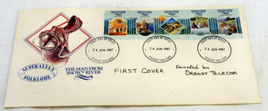 Orbost & District Historical Society
first day cover, Connell, Lee, June 1987
The Man from Snowy River" is a poem by Australian bush poet Banjo Paterson. It was first published in The Bulletin, an Australian news magazine, on 26th April 1890. The poem tells the story of a horseback pursuit to recapture the colt of a prizewinning racehorse that escaped from its paddock and is living wild with the brumbies (wild horses) of the mountain ranges. Eventually the brumbies descend a seemingly impassably steep slope, at which point the assembled riders give up the pursuit, except the young hero, who spurs his pony down the "terrible descent" to catch the mob.Two characters mentioned in the early part of the poem are featured in previous Paterson poems; "Clancy of the Overflow" and Harrison from "Old Pardon, Son of Reprieve".The town of Orbost is situated on the Snowy River and the town has always been "the heart of Snowy River country".A first day cover for "The Man From Snowy River" stamps. There is a picture of a saddle in the top left-hand corner. There is a strip 5 stamps on the envelope and it has been stamped at Orbost Post Office. This strip has 5 scenes based on the Banjo Patterson legendary poem by the same name. The stamps include: At The Station, Mountain Bend, The Terrible Descent, At Their Heels and Brought Them Back.first-day-cover man-from-snowy-river stamps philately -
 Bendigo Historical Society Inc.
Document - CHRISTMAS REEF GOLD MINING CO. COLLECTION: PLAN OF MINE
Hand drawn plan of mine, showing spurs, slate, lava. Christmas Reef shaft and Great Western shaft drawn. Notations in pencil. On left hand side 'Memo: the shaft of the Christmas Reef Co is about 5 chains north of Great Western Cos shaft. The strata and surface pitch north, assumed at same rate. The working of Allingham and Moore's Trib Co are taken from their reports in Bendigo Advertiser May 1872 to May 1873. Jas Down Mgr' Scale on plan 20 ft to 1 inch Legend shows sandstone, slate and quartz.Bendigo Advertiserbendigo, mining, christmas reef gold mining -
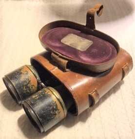 8th/13th Victorian Mounted Rifles Regimental Collection
Equipment - Binoculars
These binoculars belonged to Lieutenant Thomas Spencer Howard, 8th Australian Light Horse Regiment. Howard was killed in action in the charge at the Nek, Gallipoli peninsula, on 7 August 1915. Howard was a 25-year-old grain dealer from Melbourne when he enlisted in the AIF and was appointed a lieutenant in the 8th ALH on 24 October 1914. He had pre-World War One service with 10th Light Horse (VMR), 11th & 29th Light Horse Regiments. Prior to sailing he was presented with these binoculars: “Lieut TS Howard 8th LH, 3rd Aust Imp Exped’y Force, From Chief and Staff of J.F.C. Jan 1915”. They were returned, together with his spurs, to his family following his death. Metal binoculars with leather case with metal presentation plaque on inside flap lid. Lieut TS Howard 8th LH, 3rd Aust Imp Exped’y Force, From Chief and Staff of J.F.C. Jan 1915howard, light horse, 8th, gallipoli, binoculars, wwi, world war one, nek -
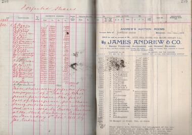 Bendigo Historical Society Inc.
Administrative record - South Nell Gwynne G.M. Co. N.L. Share Register, 1939 to 1941
See Geological Survey Victoria: GSV Reference ID: 43711 South Nell Gwynne 'The Central Nell Gwynne which recently took over the reef prospected by Nell Gwynne ( B.M.L.) will continue to work the mine until the new Company, South Nell Gwynne Gold Mining Company is ready to take over. The main development work is at the 1080 feet level where stoping is being carried out on a spur system which has shown several colours of gold. ...The trial crushing in shaft sinking gave 4 dwt per gold per ton..... ' ( 29th July 1938, 'The Herald, Melbourne) 1941 Geological Survey Vic: SOUTH NELL GWYNNE, BENDIGO. MINING AND GEOLOGICAL JOURNAL: ' Journal, dark green hard cover, buff bindings on spine and corners. On spine of book in gold print: ' Share Register South Nell Gwynne G.M. Co. N.L.' South Nell Gwynne Gold Mining Company share register, 1938 to 1941. Alphabetical index in front, four hundred pages. Entries detail date of purchase, name of shareholder, distinctive number range, call account and paid by. Page 299 has a list of forfeited shares in the Company with a list of shares sold by James Andrew & Co., on 8th December 1938. Shares were 'forfeited for non payment of the 2nd call of threepence per share'. Share register is part of the Margaret Roberts Collection. bendigo, goldmining, goldfield, south nell gwynne gold mining co., nell gwynne, margaret roberts collection, mr j.j. stanistreet, mine manager -
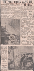 Bendigo Historical Society Inc.
Newspaper - VICTORIA HILL - VICTORIA HILL NEWSPAPER ARTICLE
Two copies of newspaper articles titled ''The Past Comes Alive on 'The Hill'' from the Bendigo Advertiser dated 3/7/1971. Some history, a guided tour by two busloads of students and some plans are mentioned in the article. There are also two photos in the article. In one photo three Rotarians of Bendigo South, Mr. Vic Wodetski, Mr. Jack Bright and Mr. A. E. Richardson are inspecting some of the concentric rings of iron oxide and the quartz spur running through the centre of the outcrop on Victoria Hill. In the other photo Mr. jack Bright is looking at the natural curves of colour in the stone of Victoria Hill.newspaper, bendigo advertiser, victoria hill, victoria hill newspaper article, central deborah, victoria hill open cut, joss house, bendigo potteries, mr a e richardson, bendigo historical society, mr j hattam, reservoir high school, mr w j derham, rotary club of bendigo south, bendigo and district tourist association, victoria quartz mine, george lansell's big 180, theodore ballerstedt, goldmines hotel -
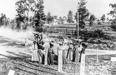 Eltham District Historical Society Inc
Negative - Photograph, Tom Prior, Feminine reception for the U.S. Fleet near Research, Victoria, 1908
With the visit of the American Fleet to Melbourne in early September 1908, volunteers from the the Automobile Club of Victoria took 100 officers on an excursion to the Black Spur past Yarra Glen on the 4th September 1908. (The area we know today as the Yarra Valley). The convoy travelled through Eltham, Research and Kangaroo Ground, where a group of women gathered to wave to them. This was one of the first motor vehicles to pass through Research. The visit of the American Fleet was a big deal at the time. A Program of activites was compiled. City buidlings were illuminated, a State reception was given and a concert was held. The Federal Parliament sat in Melbourne at that time. This photo was made using a home-made camera constructed by the photographer Tom Prior (brother of Mrs E.R. Reynolds). Reproduced on p86 of 'Pioneers & Painters'This photo forms part of a collection of photographs gathered by the Shire of Eltham for their centenary project book,"Pioneers and Painters: 100 years of the Shire of Eltham" by Alan Marshall (1971). The collection of over 500 images is held in partnership between Eltham District Historical Society and Yarra Plenty Regional Library (Eltham Library) and is now formally known as 'The Shire of Eltham Pioneers Photograph Collection.' It is significant in being the first community sourced collection representing the places and people of the Shire's first one hundred years.Digital image 4 x 5 inch B&W Negsepp, shire of eltham pioneers photograph collection, research (vic.), u.s.a. fleet, automobile club of victoria, drive, excursion, visitors, welcome, usa fleet, us fleet, waving, tom prior, pioneers and painters, reynolds prior collection, u.s fleet