Showing 13707 items
matching wye-river-bridge
-
 Flagstaff Hill Maritime Museum and Village
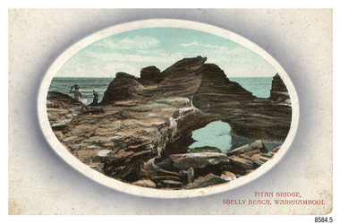
Postcard - Scenic, Warrnambool, Titan Bridge, Shelly Beach, Warrnambool, 1902-1929
The nine postcards in this set were donated together and date to the early 1900s. All but one postcard in this set shows images of Warrnambool, in the Western District of Victoria; the other has a London image. The postcards were all printed in Great Britain according to that country’s postal regulations. The fronts of all cards have titles printed in red. Most of the images on the cards are attributed to photographer Joseph Jordan and belong to the Jordan Series. The back of these cards has an outline for a postage stamp, a vertical dividing line and a heading on each side of the line to separate the Correspondence from the Address. Postcards or ‘correspondence cards’ appeared in Britain in 1894. They were plain cards with a space for the message on one side and an address on the other; regulations didn’t allow anything but the address to be written on the ‘address’ side. In 1902 the British regulations then allowed a picture to be printed on the front and the address on the back, so messages had to be written on the picture side. Soon, the regulations changed and the back was divided for a message and the address. Titan Bridge, Warrnambool – The name Titan Bridge is likely to be a reference to the huge Titan crane that was used in the construction of the Breakwater in the late 19th century. Shelly Beach is a popular swimming area with the added attraction of rock pools to investigate and rock formations to climb. Joseph Jordan - Joseph Jordan was born in 1841 in Leicester England. When he was 16 he joined the 7th Queen's Own Hussars and was sent to India at the outbreak of the mutiny. He took part in the relief of Lucknow and remained in India for eleven years. It was during this time that he became interested in photography. He was posted to New Zealand and later came to Victoria, becoming a sergeant major of the Mounted Rifles. In the mid-1880s he came to the Western district where he was responsible for establishing units of the Mounted Rifles in various country towns such as Dunkeld, Mortlake, Panmure, Bushfield, Koroit etc. He resigned from the army in 1889 and set up a professional photography studio in Liebig Street, Warrnambool. He became very well known in the Western District for family photographs, official photographs of local councillors and groups as well as views of local scenery. In 1891 he photographed the wrecked barque ‘Fiji’ at ‘Wrecks Beach’ near Princetown. His business was taken over by his son Arthur around 1917. Joseph was a keen rifle shot and in 1924 he donated the "Jordan Shield" as a prize to the Victorian Rifle Association. He was made a "Life Honorary Member" of the Warrnambool Returned Soldiers League and in 1933 he was recognised as being the oldest living soldier in Victoria. Joseph died in 1935 aged 95.The image of the Titan Bridge rock formation with figures on it suggests that the location was a popular place to visit. It captures a time when the rock formation was publically accessible. The choice of subject for this postcard indicates the popularity of Warrnambool's natural environment as a tourist attraction at a time when ships called coastal traders brought passengers and cargo to the Port of Warrnambool from ports along Victoria's southwest coast. Joseph Jordan is a significant figure in Warrnambool history as he helped to establish early units of the Mounted Rifles (G Company) in local towns during the late 1880's and later, photographed local scenes, groups and citizens of early Warrnambool.Postcard, one of nine, landscape orientation, coloured print within an oval border and mauve-toned shading. The cameo image shows two figures, one seated and one standing, beside the sea on a rough rock beside a rock formation resembling a bridge. There is no correspondence written on the card. The back has inscriptions and outlines for a postage stamp. Jordan Series, printed in Great Britain.Front, in red: “TITAN BRIDGE / SHELLY BEACH, NEAR WARRNAMBOOL” Back in black: “Jordan Series” “POST CARD” “PRINTED IN GREAT BRITAIN” “For correspondence” “The Address only to be written here”flagstaff hill maritime museum, flagstaff hill maritime village, flagstaff hill maritime museum and village, maritime museum, warrnambool, great ocean road, warrnambool and district, warrnambool scenes, local scenes, views of warrnambool, joseph jordan, jordan series, jordan photography, postcard, souvenir, correspondence, cameo postcard, landscape, shelly beach, titan bridge, titan, rock formation -
 Marysville & District Historical Society
Photograph (Item) - Black and white photograph, 1953
A black and white photograph of a bridge over the Steavenson River in Marysville in Victoria.A black and white photograph of a bridge over the Steavenson River in Marysville in Victoria. The Steavenson River is named after the Victorian Assistant Commissioner of Roads and Bridges, John Steavenson who arrived in Victoria in the early 1860s.THE BRIDGE/ MARYSVILLE '53 7340marysville, victoria, steavenson river, photograph, john steavenson -
 Kew Historical Society Inc
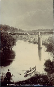
Postcard, River Yarra near Macauleys' Boathouse Kew, c.1910
The Pipe Bridge was constructed to bring fresh water from Fairfield to Kew. This bridge was destroyed in the 1934 Flood and later reconstructed.Early sepia real photo postcard of the first Pipe Bridge bringing water from the Yan Yean Reservoir to Kew. The site is upriver of the original Macauley's boathouse. Obverse: "River Yarra near Macauleys' Boat House Kew". Reverse: "(Pipe Water Line) / Kew to Fairfield above boat house / Pipe Bridge / Received from L. Bennett 1980".bridges - kew (vic.), bridges - yarra river -- kew (vic.), pipe bridge -
 Eltham District Historical Society Inc
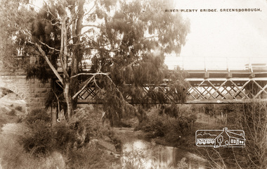
Photograph postcard, River Plenty Bridge, Greensborough
Postcard with view of bluestone bridge over the Plenty River on what is now Main Street, Greensborough. Built in 1860 by a Scottish stonemason, James Neave McKenzie. Most of the bridge was demolished in 1966 with the remaining bluestone arch preserved till 1983 when it was also demolished. This view about 1900.Digital file only Postcards scanned from the collection of Michael Aitken on loan to EDHS, 13 Feb 2018michael aitken collection, postcards, greensborough, plenty river bridge, plenty river -
 Eltham District Historical Society Inc
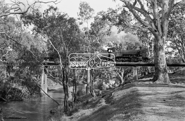
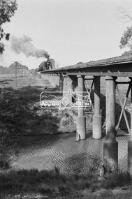
Photograph, Steam locomotive K-158 crossing the railway bridge over the Campaspe River at Rochester, Victoria, c.November 1963, 1963
It is the railway bridge over the Campaspe River at Rochester, Vic. original to the construction of the line. It was taken late on a Saturday morning and shows the regular goods train of that period approaching, then crossing the bridge. I originally planned to take just one view. The approaching train was first then it was a rapid run back along the raised river bank to get the broadside shot. I had little time to steady myself or properly check camera settings, hence the slightly soft focus etc. The train would eventually continue over the Echuca Iron Bridge into NSW. I think its ultimate destination was Deniliquin but not sure.Digital TIFF file Scan of 35mm Ilford FP3 black and white negative transparencygeorge coop collection, k-158, k-class steam locomotive (vr newport workshops), railway bridge, campaspe river, rochester -
 Eltham District Historical Society Inc
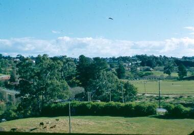
Photograph, Fay Bridge, Centenary celebration, Monash Bridge, Hurstbridge, 7 November 2017
The area of Hurstbridge was originally known as Hurst’s-bridge after the timber bridge built over the Diamond Creek near Hurst’s station in late 1881/early 1882. It was replaced by a new concrete bridge designed by Sir John Monash over the Diamond Creek near Hurst's home of 'Mia Mia' at Hurstbridge. The official opening of the new Monash bridge at Hurstbridge was held 3 November 1917.fay bridge collection, 2017-11-07, hurstbridge, hurstbridge heritage trail, monash bridge, ruins -
 Greensborough Historical Society
Photograph - Digital image, Frank Robinson, Greensborough near Plenty River bridge and football ground, 1954_
Greensborough near Plenty River bridge and football ground. The Blackjack property, house and acres of fruit orchards ran down to the Plenty River off Hume Street Greensborough and was the home of the Robinson family to late 1956. The photographs were taken as slides by Frank Robinson and digitised by his son James in 2015.Digital copy of colour photograph.robinson family, plenty river, blackjack -
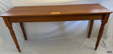 Flagstaff Hill Maritime Museum and Village
Furniture - Table, Ralph Speirs, Warrnambool Triton Woodwork Club, 2009
The turpentine timber used to construct this table was originally used to build the second Hopkins River bridge in 1895. That long timber truss road bridge was built across the river close to the river mouth. The first Hopkins River bridge was built in 1862. That bridge was replaced by the second bridge, built in 1895. In 2001 the new third bridge was built to replace the 1895 bridge, in a design to look similar to the 1895 bridge. The timber from the second bridge was recycled to make this hall table, a cheeseboard presented to the Mayor at that time, and other mementos. The plaque attached to the table states the table was made in 2009 by Ralph Speirs, Warrnambool Triton Woodwork Club. The table is significant for its connection with the second Hopkins River bridge, built in 1895. The timber used to make the table has been recycled from the second Hopkins River bridge that was destroyed to make way for the new, third bridge. The Timber Truss Hopkins River Bridge was classified with State Significance on 16th April 1996, being the oldest of six surviving timber truss bridges in Victoria and the most intact timber road bridge of any type for its size and age. Its design was unique within Australia. It was the largest timber bridge built in Victoria during the 1890s. The bridge was of importance to the economical development of the region, opening up access to allow ease of trade and social connections between the eastern region of southwest Victoria and the town, later city, of Warrnambool and regions further west.Table made from turpentine timber. The timber was recycled from the second Hopkins River Bridge after the bridge was destroyed. The bridge was built in 1895. The table was constructed in 2009 by Ralph Speirs, Warrnambool Triton Woodwork Club. The front corners of the table are rounded and bthe back corners are straight. A plaque with eight rows of text is attached to the table."TABLE BUILT FROM TURPENTINE TIMBER RECYCLED FROM THE SECOND HOPKINS RIVER BRIDGE, BUILT IN 1895 AND DEMOLISHED IN 2000 TO BE RPLACED BY THE PRESENT THIRD BRIDGE. CONSTRUCTION BY RALPH SPEIRS, MEMBER OF WARRNAMBOOL TRITON WOODWORK CLUB, IN 2009"flagstaff hill, warrnambool, hopkins river, bridge, 1895, 2009, ralph speirs, warrnambool triton club, domestic furniture, table, hall table, side table, timber table, hall stand, furniture -
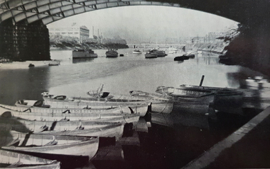 Ballarat Heritage Services
Photograph - Image, Below Princes Bridge, Melbourne
The Yarra River flows through Melbourne, the capital of Victoria. Photograph of the Princes Bridge on the Yarra River, Melbourne.melbourne, yarra river, princes bridge -
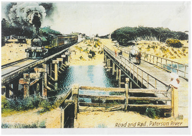 Chelsea & District Historical Society Inc
Photograph - Patterson River Postcards, Rail and Road Bridge, c 1905
The first bridge over the river was built in the early 1880's, prior to this it was a pontoon bridge. Dr. Sheldon's Magnetic Liniment was advertised as being able to relieve "at once rheumatism, lumbago, lame back, cuts, bruises or burns, will effect a cure in a remarkably short time. Price 1s 6d and 3s"Two postcards of the road bridge (Nepean Highway) with a horse and cart and people crossing and single line rail bridge , with a steam train crossing over Patterson River, near the mouth of the river. One card has been coloured, the other has been modified to advertise Dr Sheldon's Magnetic Liniment.DR SHELDON'S NEW DISCOVERY 16' & 3' BANISHES ALL PAINS AT CARRUM VICTORIApatterson river, road bridge, rail bridge, dr sheldon's linament, chelsea, steam train, transport, chelsea bridge, patterson bridge -
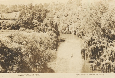 Kew Historical Society Inc
Photograph, River Yarra at Kew, c.1927
The River Yarra was a popular subject for photographic postcards. The postcards provide an interesting perspective of plantings on the banks of the Yarra at various periods. Small, sepia coloured real photo postcard of the River Yarra at Kew. The bird's eye view, presumably taken from Victoria Street Bridge shows the banks of the Yarra in the foreground densely planted with weeping willows. There is also canoe in the foreground. The expanse of lawn in the middle ground is that of 'Swinton', the tower of which can faintly be seen at the top centre of the view. "RIVER YARRA AT KEW / REAL PHOTO SERIES M. 2908 "real photo postcards, yarra river -- kew (vic.), postcards -- 1920s -
 Greensborough Historical Society
Photograph - Digital image, Frank Robinson, Looking north over the football ground with bridge over Plenty River, 1954_
Looking north over the football ground with bridge over Plenty River. The Blackjack property, house and acres of fruit orchards ran down to the Plenty River off Hume Street Greensborough and was the home of the Robinson family to late 1956. The photographs were taken as slides by Frank Robinson and digitised by his son James in 2015.Digital copy of colour photgraph.robinson family, blackjack, plenty river -
 Kew Historical Society Inc
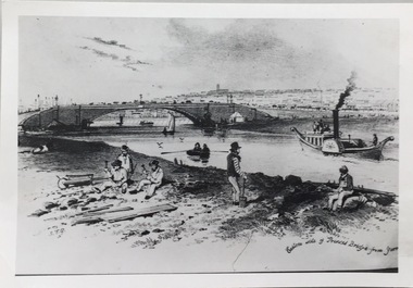
Photograph - Photograph (copy), S T Gill, Eastern side of Princess Bridge From Yarra, 1860-1880 (original)
Copy of a painting (or etching) by S.T. Gill showing the Yarra River at Princess Bridge, Melbourne.Inscription reverse: "Eastern side of old Princess Bridge from Yarra"reproductions -- s t gill, princess bridge -- river yarra - melbourne (vic.) -
 Eltham District Historical Society Inc
Photograph, Fay Bridge, Wattletree Road Bridge, Eltham, c.Jan. 1990
Shows Eltham Council sign notifying temporary closure of the bridge 19 Feb to 27 April 1990 for redecking. Illustrates the timber decking of the bridge and pedestrian footbridge extension on southern side.fay bridge collection, 1990-01, wattletree road bridge -
 Port Fairy Historical Society Museum and Archives
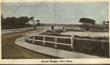
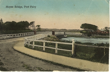
Photograph - Postcard, Moyne bridge
Photograph hand tinted of the Moyne river road bridge taken from Gipps Street showing house on the far bank on the right side taken for use as a PostcardMoyne Bridgemoyne bridge 1910, moyne river, traffic, gipps street -
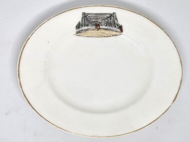 Wodonga & District Historical Society Inc
Souvenir - Souvenir Plate - Union Bridge, Albury, Hancock and Sons, c1930s
This item is from a collection donated by descendants of John Francis Turner of Wodonga. It is one of many souvenirs produced to represent landmarks in the Albury-Wodonga district. The first punt across the Murray River at Albury was established by Robert Brown in 1843. In 1861 the first Union Bridge was built. It was demolished to make way for the second Union Bridge which opened in 1898. This second bridge closed and was eventually demolished after the third and existing bridge was opened in 1961. Hancock and Sons, Stoke on Trent - Sampson Hancock, a prominent Wesleyan Methodist, started potting in 1857. In 1891 he established the business of Sampson Hancock & Sons. Sampson died in 1900 and the business was continued by his three sons - Jabez, Harry and Arthur. In 1935 the business was in financial difficulty and was made bankrupt. It was restarted as S Hancock & Sons (Potters) Ltd. and moved to the Gordon Works, Hanley - which was renamed the Corona Works. The restarted company was not a success and it finally closed in 1937, having been put into receivership on 23rd March. This information helps to establish provenance of this plate.This item comes from a collection used by a prominent citizen of Wodonga. It is representative of a items produced to represent historic landmarks or features of the district.Fine China round plate with gilt edge and image of the Union Bridge, AlburyBeneath image: " THE BRIDGE OVER THE MURRAY AT ALBURY, NSWALESalbury souvenirs, union bridge albury, albury-wodonga border, murray river bridges -
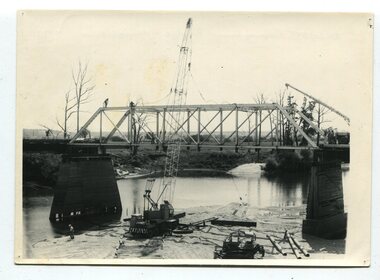 Orbost & District Historical Society
black and white photographs, 1977
This is a series of photographs of the demolition of the 1922 bridge across the Snowy River at Orbost. This bridge over the Snowy River was opened on July 4 1922. It was constructed in 1922 alongside the previous suspension bridge. Its building was a combined effort of the Victorian Railways and the Country Roads Board at a cost of 35,000 pounds. It was replaced in 1976 by the present bridge after several major floods.This bridge was replaced in 1976 after several major floods. These photographs record the demolition of that bridge.Ten black / white photographs of a road bridge demolition. In the photographs are cranes, one on a barge, and workmenon back - Orbost Snowy River Bridge demolition 1977 -
![The Fairfield Bridge [circa 1891]](/media/collectors/550653872162f11fb04854aa/items/579eab98d0cdd117c4af1c89/item-media/579eac23d0cdd117c4afb1ad/item-fit-380x285.jpg) Kew Historical Society Inc
Kew Historical Society IncPrint, The Fairfield Bridge [circa 1891], c. 1891
This work forms part of the collection assembled by the historian Dorothy Rogers, that was donated to the Kew Historical Society by her son John Rogers in 2015. The manuscripts, photographs, maps, and documents were sourced by her from both family and local collections or produced as references for her print publications. Many were directly used by Rogers in writing ‘Lovely Old Homes of Kew’ (1961) and 'A History of Kew' (1973), or the numerous articles on local history that she produced for suburban newspapers. Most of the photographs in the collection include detailed annotations in her hand. The Rogers Collection provides a comprehensive insight into the working habits of a historian in the 1960s and 1970s. Together it forms the largest privately-donated collection within the archives of the Kew Historical Society.A reproduction of a photograph of the Fairfield Bridge. The bridge was one of the first constructed for the Outer Circle Railway in 1891. Its supervising engineer was [Sir] John Monash. The bridge was later to be repurposed as a road linking the Chandler Highway to Fairfield."Outer Circle Railway Bridge over River Yarra at Fairfield (last section of line opened 1891)"fairfield bridge, chandler highway bridge, dorothy rogers, john monash, outer circle railway -
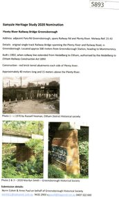 Greensborough Historical Society
Document - Submission, Norm Colvin et al, Banyule Heritage Study 2020 Nominations - Plenty River railway bridge Greensborough, 2020
Part of the single track railway extension of 1902 from Heidelberg to Eltham, the Plenty River railway bridge Greensborough, was nominated for the Banyule Heritage Study 2020. This nomination was prepared by Norm Colvin & Anne Paul on behalf of the Greensborough Historical Society1 p. Text and photographshurstbridge rail line, plenty river, banyule heritage study 2020 -
 Ballarat Heritage Services
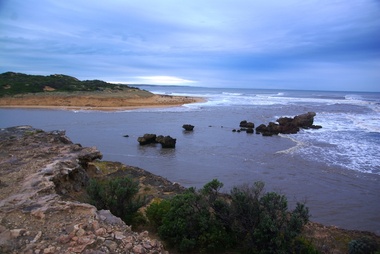
Photograph - Digital photographs, L.J. Gervasoni, Hopkins River Mouth in flood, c2010 - 2017
The flooded Hopkins River flows into the sea at Warrnambool.hopkins river, mouth, point ritchie, bluehole, warrnambool, coast, coastal, beach, seascape, flood -
 Ballarat Heritage Services
Digital photographs, L.J. Gervasoni, Hopkins River Mouth in flood as the waters receed, c2010 - 2017
Colour photograph of the mouth of the Hopkins River at Warrnambool,hopkins river, mouth, point ritchie, bluehole, warrnambool, coast, coastal, beach, seascape, flood, post flood, geology, coastal geomorphology, waters receeding -
 Ballarat Heritage Services
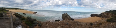
Digital photographs, L.J. Gervasoni, Hopkins River Mouth - panorama, c2010 - 2017
Panoramic photograph of the mouth of the Hopkin's River at Warrnambool.hopkins river, mouth, point ritchie, bluehole, warrnambool, coast, coastal, beach, seascape, coastal geomorphology, pano -
 Ballarat Heritage Services
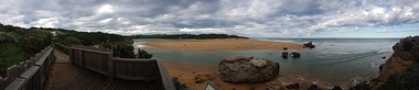
Digital photographs, L.J. Gervasoni, Hopkins River Mouth - panorama, c2010 - 2017
Colour photograph of the mouth of the Hopkins River, Warrnambool.hopkins river, mouth, point ritchie, bluehole, warrnambool, coast, coastal, beach, seascape, coastal geomorphology, pano -
 Port Fairy Historical Society Museum and Archives
Photograph - Postcard, Moyne Bridge, Port Fairy
Hand tinted photograph of Moyne river road bridge taken looking East showing house on Griffith street on the right side in the background taken for use as a PostcardMoyne River, Port Fairymoyne bridge, 1910, river, road, gipps street -
 Eltham District Historical Society Inc
Photograph, Shire of Eltham, New bridge over the Plenty River, Lower Plenty, Nov. 1966
Newly constructed single span bridge on Main Road (now Lower Plenty Road) crossing the Plenty River at Lower Plenty. Site of Heidelberg Golf Club and Lower Plenty Hotel in the background. This was the boundary between the Shire of Eltham and the City of Heidelberg.This photo forms part of a collection of photographs gathered by the Shire of Eltham for their centenary project book ,"Pioneers and Painters: 100 years of the Shire of Eltham" by Alan Marshall (1971). The collection of over 500 images is held in partnership between Eltham District Historical Society and Yarra Plenty Regional Library (Eltham Library) and is now formally known as 'The Shire of Eltham Pioneers Photograph Collection.' It is significant in being the first community sourced collection representing the places and people of the Shire's first one hundred years.Digital imagesepp, shire of eltham pioneers photograph collection, lower plenty, bridge -
 Bendigo Historical Society Inc.
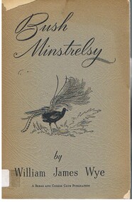
Book - ALEC H CHISHOLM COLLECTION: BOOK ''BUSH MINSTRELSY'' BY WILLIAM JAMES WYE
Book. ALEC H CHISHOLM COLLECTION. A 31 page soft cover book of verse dedicated to 'Australia's Soldier Sons' by William James Wye. Published in Melbourne , 1941 by the Bread & Cheese Club. Designed and printed by Oxford Press, Melbourne. B & W photo of the author opposite title page. Catalogue sticker '2049 WYE' on spine. Drawing of a lyrebird on cover.William James Wyebooks, collections, poetry, alec h chisholm collection, poetry, william james wye -
 Lakes Entrance Historical Society
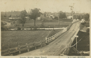
Postcard, Vogt Bairnsdale, Tambo River Swan Reach, 1920 c
Note on back to Ella from her brother Don dated 1920Black and white postcard showing the old Swan Reach bridge over the Tambo River looking east. Buildings L to R Riverslea guesthouse and school with high pitched roof. Swan Reach VictoriaTambo River Swan Reachwaterways, boats and boating, township, guesthouses, bridges -
 Victorian Interpretive Projects Inc.
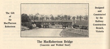
Image, MacRobertson's Bridge, 1934
Confectionery king MacPherson Robertson personally funded the £19 000 cost of the steel arch MacRobertson or Grange Road Bridge (1934) as a gift to Victoria for its centenary. (http://www.emelbourne.net.au/biogs/EM00234b.htm)A steel bridge over the Yarra River, Melbourne. The bridge was funded by MacPherson Robertson.macrobertson, bridge -
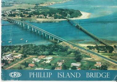 Phillip Island and District Historical Society Inc.
Booklet, Official Opening of the Phillip Island Bridge at San Remo 1969 and notes by the Bridge engineer, Tom Russell, 1969
Prior to 1939 access to the Island was by punt from San Remo or car ferry from Stony Point. A bridge was opened in 1940 but increased traffic and low load capacity was a problem. The decision to build a new bridge was made in the 1960s.HistoricalColoured, bound booklet with a photo of the old and new Phillip Island bridges on the cover and the CRB logo and name on rear. It includes the order of proceedings for the opening and bridge statistics, plans and contractor information. Also photos of construction and a history of travel to the Island before a bridge was built and the first bridge. There is also a 2 page typed document written by the bridge engineer who gives a brief history of access to the Island and problems at the opening with access and a rebel who tried to open it unofficially.Official Opening of the Phillip Island Bridge at San Remo by The Hon. M.V. Porter, MLA. Minister of Public Works. November 21 1969bridges, 2nd phillip island bridge construction, tom russell, phillip island bridge opening 1969