Showing 1560 items matching " site plan"
-
 Melbourne Tram Museum
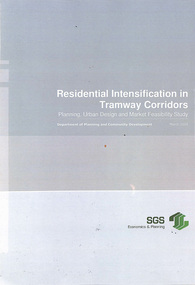
Document - Report, SGS Economics and Planning, "Residential Intensification of Tramway Corridors", May. 2009
Report - 130 pages - wire bound, plastic and card covers, titled "Residential Intensification of Tramway Corridors", prepared for the Department of Planning and Community Development by SGS Economics and Planning March 2009. Look at the development along the Nicholson St and the West Preston lines in particular. Does a detail examination of the development opportunities, including major sites that were available at the time. Does not appear to address how to capture the value of having a tram line along these areas or how to provide additional services. Development has taken place since along these and other corridors. Final Report. Table of contents and Executive Summary scanned.trams, tramways, tram routes, east preston, nicholson st, passengers, development -
 Ringwood and District Historical Society
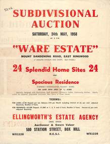
Flyer, Subdivisional Auction Sale Brochure, Ware Estate, East Ringwood, Vic. - 1958
Folded double-sided advertisement for auction of 24 home sites and existing residence on Saturday, 24th May, 1958, including locality map, subdivision layout, terms of sale, and summary of local facilities and services. Additional plan of lots 28-33 dated 26/10/60 by Licensed Surveyor for Kirkpatrick & Webber, 225 Maroondah Highway Ringwood headed Plan of Subdivision of part of Crown Allotment 26A Parish of Ringwood.Subdivision includes Mount Dandenong Road, Ware Crescent, Davey Drive, and Grey Road (later Grey Street). Timber residence included in the subdivision was formerly Ware Kindergarten Holiday Home. (Agent) Ellingworth's Estate Agency, 580 Station Street, Box Hill - (Phone) WX1228. -
 Kew Historical Society Inc
Photograph, Kew Bowling Club RVBA “Hotham Premiers” Division 1, 1983-1984
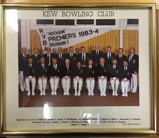
Sports Clubs in Kew in the final decades of the 19th century and in the early 20th century were often umbrella organisations with facilities for a number of sports. Typically in Kew, this included teams in lawn bowls, tennis and croquet. The Kew Bowling Club was formed in 1880 while the privately owned Auburn Heights Recreation Club was opened in 1904. By 1998, the two Clubs decided to amalgamate at the Auburn Heights site in Barkers Road, forming the Kew Heights Sports Club. The combined club was itself taken over by the Melbourne Cricket Club in 2012 becoming MCC Kew Sports Club. In 2017 MCC Kew closed and its landholding was subsequently sold to Carey Baptist Grammar School. Both the Kew and Auburn Heights Clubs assembled important collections. These historically significant and large collections were donated to the Society in 2020. The collections include manuscripts, pictures, trophies, plans, honour boards etc. References Barnard FGA 1910, 'Sports and Pastimes' in Jubilee History of Kew Victoria: Its origin & progress 1803-1910. Nixon NV 1980, The History of the Kew Bowling Club 1880-1980. Reeve S 2012, City of Boroondara: Thematic Environmental History, p.216.The combined collections of the four sporting clubs making up the collection number hundreds of items that are historically significant locally. They are also significant to the sporting history of the greater Melbourne area and to the sports of lawn bowls and tennis in Australia in the 19th and 20th centuries. The collection illuminates two of the Victorian historic themes - 'Building community life' through forming community organisations and 'Shaping cultural and creative life' by participating in sport and recreation.RVBA White Pennant awarded to Kew Bowling Club as “Hotham” Premiers Division 1, 1983-84. [The item is part of the large historic Kew Bowling Club collection (1880-1988) gifted to the Kew Historical Society in 2020].kew bowling club - wellington street - kew (vic), clubs - lawn bowls - kew (vic), kew bowling club - rvba pennants -
 Kew Historical Society Inc
Work on paper - Framed Drawing, Kew Bowling Club ‘The Original Badge’, 1980-1998
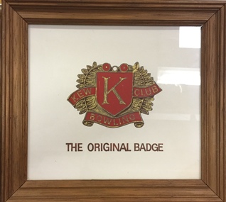
Sports Clubs in Kew in the final decades of the 19th century and in the early 20th century were often umbrella organisations with facilities for a number of sports. Typically in Kew, this included teams in lawn bowls, tennis and croquet. The Kew Bowling Club was formed in 1880 while the privately owned Auburn Heights Recreation Club was opened in 1904. By 1998, the two Clubs decided to amalgamate at the Auburn Heights site in Barkers Road, forming the Kew Heights Sports Club. The combined club was itself taken over by the Melbourne Cricket Club in 2012 becoming MCC Kew Sports Club. In 2017 MCC Kew closed and its landholding was subsequently sold to Carey Baptist Grammar School. Both the Kew and Auburn Heights Clubs assembled important collections. These historically significant and large collections were donated to the Society in 2020. The collections include manuscripts, pictures, trophies, plans, honour boards etc. References Barnard FGA 1910, 'Sports and Pastimes' in Jubilee History of Kew Victoria: Its origin & progress 1803-1910. Nixon NV 1980, The History of the Kew Bowling Club 1880-1980. Reeve S 2012, City of Boroondara: Thematic Environmental History, p.216.The combined collections of the four sporting clubs making up the collection number hundreds of items that are historically significant locally. They are also significant to the sporting history of the greater Melbourne area and to the sports of lawn bowls and tennis in Australia in the 19th and 20th centuries. The collection illuminates two of the Victorian historic themes - 'Building community life' through forming community organisations and 'Shaping cultural and creative life' by participating in sport and recreation.Framed and glazed graphic design of the original badge of the Club. [The item is part of the large historic Kew Bowling Club collection (1880-1988) gifted to the Kew Historical Society in 2020].kew bowling club - wellington street - kew (vic), clubs - lawn bowls - kew (vic) -
 Melbourne Tram Museum
Document - Report, Victorian Parliament, "Report - The Parliamentary Standing Committee on the Proposed Kew to Doncaster Electric Railway Extension", Dec. 1930
Printed - 12 page foolscap, stapled on left hand side, 2 sections, Victorian State Parliamentary Report titled "Report - The Parliamentary Standing Committee on Railways on the Proposed Kew to Doncaster Electric Railway Extension", together with minutes of evidence, book of reference, plan and map, dated 4/12/1930. References a 1928 document, looks at construction costs, sites for railway stations, estimated revenue and expenditure, existing Kew line financials, town planning, bus services, MMTB input, tram services, alternatives, committee views, recommendations and a map of proposed routes, showing roads and tram services. Includes references to the Kodak estate and APM proposals at Fairfield. See Reg Item 2102.3 for the 1928 report.trams, tramways, doncaster, railways, public transport, kew -
 Port Melbourne Historical & Preservation Society
Audio - PMHPS Meeting, Fairstar, Robert PRADOLIN and Rob JELL, Glen Stuart, 1996
... . Discussing plans for HMAS Lonsdale site development. Recording... to Faristar. Discussing plans for HMAS Lonsdale site development ...Recording of PMHPS meeting on 22.01.1996. Recorded by Glen STUART at the Liardet Community Centre. Speakers were Robert PRADOLIN of Faristar and Rob JELL, consultant to Faristar. Discussing plans for HMAS Lonsdale site development. Recording duration 01:11:17built environment - commercial, faristar, sandridge lagoon, robert pradolin, rob jell -
 Federation University Historical Collection
Photograph - Brewery Building, Ballarat School of Mines Brewery Building, 06/10/2011
In 1872 William Tulloch and Alexander McLaren constructed a new brick 'Royal Standard Brewery' to the design of architect Henry R. Caselli. They had been operating a much smaller 'Royal Standard' Brewery, possibly since 1859. The Ballarat Brewing Company was established in 1895 and took over operations of the 'Royal Standard'. This new company resulted in the merger of the 'Royal Standard Brewery', James Coglans 'Phoenix Brewery' (Warrenheip) and Henry Leggo's 'Barley Sheaf Brewery' (Creswick Rd). J. Coglan and W. Tulloch were principals of the new company. By 1912 the Ballarat Brewery buildings fronting Armstrong Street were upgraded and new plant installed. Ballarat Brewing Company was well established as a thriving business. In 1926 'Ballarat Bertie' (the cellar-man) advertising image was introduced. It was used successfully until 1994 on 'Ballarat Bitter' labels. During the1940s and 50s the Ballarat Brewing Company was significantly upgraded and extended equipment and buildings. In 1959 Carlton and United Breweries purchased the Ballarat Brewery, its brewing rights and the land (but not the 114 BBC hotels or the Dana Street offices). The Lydiard Street frontage become the 'front' of the CUB Brewery. CUB ceased brewing at the Ballarat Brewery site in 1989 and closed the plant. Four years later the 'brewery site' was purchased by the Ballarat School of Mines to enlarge its campus area as TAFE was a rapidly expanding areas of education. In 1994 plans were developed for the 'Brewery Complex' with careful regard for needed educational facilities and due concern regarding historical aspects of the site and its buildings. There was close consultation and cooperation with the Ballarat City Council during the planning process. In 1995 most of the Brewery buildings were demolished by some special structures and features are preserved. The old brewery chimney was retained as a permanent reminder of the original industrial site, as were two boilers. The SMB Brewery Complex was completed in 1996 and reflects aspects of the former brewery's appearance. It was opened by Prime Minister John Howard on 28 February 1997. Further details at http://guerin.ballarat.edu.au/curator/buildings/site_listing_brewery-complex.shtml Twenty five colour photographs of the Brewery Building at the University of Ballarat SMB (Ballarat School of Mines) campus. The Brewery Building is built on the site of the former Ballarat Brewery and incorporates the chimney and 'Cowley' boilers from that site. ballarat school of mines, henry richards caselli, henry caselli, ballarat brewing, brewery, beer, cowleys foundry, carlton and united breweries, ballarat brewery site -
Villa Alba Museum
Document, Villa Alba Museum Archaeological Test Excavations, 2002
A preliminary report on archaeological test excavations, conducted on 5 & 7 September 2002 by Maddy Atkinson (Ripple Arc). The purpose of the excavations was twofold. Firstly, to conduct subsurface testing at Villa Alba to determine the presence, location and depth below ground of archaeological remains relating to a number of landscape features identified in historical plans, photographs, survey field books and aerial photographs. Secondly, soils surrounding the Villa Alba mansion, which have been found to be contaminated with lead will need to be removed up to a depth of up to 0.6 metres. Removal of deposits from the site may have an adverse impact on any archaeological remains existing below the surface.Contents: Acknowledgements / Abbreviations / List of figures / List of tables / List of plates / Introduction / Historical context / Methodology / Results and interpretations / Discussion / Recommendations / References / Appendix 1 - Plates / Appendix 2 - Content list / Appendix 3 - Copy of Heritage Victoria permit.non-fictionA preliminary report on archaeological test excavations, conducted on 5 & 7 September 2002 by Maddy Atkinson (Ripple Arc). The purpose of the excavations was twofold. Firstly, to conduct subsurface testing at Villa Alba to determine the presence, location and depth below ground of archaeological remains relating to a number of landscape features identified in historical plans, photographs, survey field books and aerial photographs. Secondly, soils surrounding the Villa Alba mansion, which have been found to be contaminated with lead will need to be removed up to a depth of up to 0.6 metres. Removal of deposits from the site may have an adverse impact on any archaeological remains existing below the surface. conservation studies, conservation reports, archaeological reports, villa alba museum -
 Bendigo Historical Society Inc.
Plan - MARKS COLLECTION: PLAN OF COLIBAN CHANNEL
... . Plan also shows Railway reserve, machinery site (un-named) Plan ...Plan, hand drawn on waxed paper: Coliban Channel through centre of plan. Written on LH side right of passage over 1 1/2 chains from Melbourne Road Written in red rail water may be returned into channel here VWS fence 3682 drawn in dotted line. Head of drop to bottom of channel drawn inside elevation view on bottom RH corner of plan. Plan also shows Railway reserve, machinery site (un-named)plan, bendigo, coliban channel -
 Bendigo Historical Society Inc.
Document - MARKS COLLECTION: PLAN OF SANDHURST CITY CENTRE AND SURROUNDING AREA ( NO. 1 )
Plan on heavy parchment - section neatly cut out of area now Kennington. Written on plan in black print ' Sheet No. 1. Sandhurst'. Plan shows Government Camp, Commissioner's Gully, old cemetery site, manure depot, cattle market, Benevolent Asylum Reserve, railway reserve. Landowners' names on allotments. On bottom lithographed at the Department of Lands and Survey, Melbourne, by D. Henerson, March 12th., 1867 Plan part of George Lansell, Fortuna auction, documents found in wardrobe purchased by Marks family in 1930's.bendigo, planning, sandhurst 1867 -
Lakes Entrance Historical Society
Book, East Gippsland Regional Planning Committee, Sites of Historical Significance in the East Gippsland Region, 1980
Details of historical sites with comments about the money raising activities. History of construction..historic sites, charities, architecture -
 Flagstaff Hill Maritime Museum and Village
Photograph - Historical, building, Lighthouse Keeper's Quarters Warrnambool, Ca. 1917
This photograph of the Warrnambool Lighthouse Keeper's Quarters was donated together with an accompanying letter written by John Lindsay on October 21st, 1997. The letter was addressed to Howard Nicholl, the Director of Flagstaff Hill at that time. The following information was gleaned from the contents of the letter and the labels attached to the photograph:- The photograph of the Cottage was taken in about 1917. The woman is Gertrude Shade, married to James Shade, who was the Warrnambool Town Council's Officer responsible for keeping records of Shipping activity entering and leaving the busy Port of Warrnambool. The couple and their children, Janet and William, were residents of the Assistant Lighthouse Keeper's Quarters at that time. The family is pictured in the garden on the west side of the building. A washhouse, these days referred to as a laundry, is behind the building and had already been removed when the Flagstaff Hill Planning Board had access to the site in 1972. The corrugated iron veranda was replaced in the 1980s with a smaller covered entry. Janet Shade married the man who lived across the road, Stewart Lindsay, in 1935. Stewart was employed by Nestle at the age of sixteen, working in the export department. He was acting Manager when the Manager became ill, supervising the loading of dairy products and biscuits into the holds of the waiting ships, where they were then exported to Indonesia. Many of the ships were registered in Liberia and the seamen were called 'lascar seamen, or Indian Sailors. Janet and Stewart had a son, John Stewart Lindsay, who was a Pharmacist, a member of the Warrnambool City Council, the Mayor of the City of Warrnambool, a former Director of Flagstaff Hill, and Chairman of the Flagstaff Hill Advisory Committee.This photograph has significance as a historical record of the Warrnambool Lighthouse Kerr'er's Quarters in 1917. The photograph connects the cottage to local families, to local industry, to the Port of Warrnambool, and to overseas exports from Warrnambool. Photograph from c. 1917 depicts the western side of the Warrnambool's Lighthouse keeper's Quarters constructed in bluestone, which was where the Assistant Lighthouse Keeper resided. The image shows the corrugated iron lean-to, and other rooms that were added to the original building after 1872, which were removed in the 1970s due to their poor condition. The members of the family pictured were residents at the time; Gertrude Shade (Mrs James Shade), her daughter Janet and her son William. Inscriptions are on the reverse and the accompanying envelope. Typed label "Gertrude Shade with William and Janet. Lighthouse Keeper's Cottage, Flagstaff Hill, Merri St Warrnambool" Stamp "John Stewart Lindsay, Pharmacist, --0 Thompson Street Warrnambool 3280" "HOWARD NICHOLL / FLAGSTAFF HILL / MERRI STREET" " KEEP OUT OF REACH OF CHILDREN / Lindsay's Pharmacy / 119 Liebig Street, Warrnambool / Tel. 5561 4310" [round symbol of mortar and pestle] Typed letter (from John Lindsay to Howard Nicholl, October 21 1997)flagstaff hill, warrnambool, maritime museum, shipwreck coast, great ocean road, lighthouse keeper's quarters, lighthouse keeper's cottage, gertrude shade, james shade, janet shade, john stewart lindsay, stewart lindsay, nestle, warrnambool exports, port of warrnambool, planning board, 1917, howard nicholl, william shade, export to indonesia, janet lindsay -
 Flagstaff Hill Maritime Museum and Village
Photograph - Historical, Flagstaff Hill, Harbourmaster’s Quarters, 1970s
The photograph shows a cottage, Harbourmaster’s quarters that still stands on the east of the Lady Bay Lighthouse and Historic Precinct at Flagstaff Hill in Warrnambool. The name was changed to the Lighthouse Lodge, and today guests can stay at the property. This photograph, a print, is one of a set of five that show the site of Flagstaff Hill. It is presumed to have been taken by John Lindsay, Founding Director of Flagstaff Hill Maritime Museum and Village. One of the photographs in the set has the pencil inscription "Photo J Lindsay". It was taken in the early 1970s during the initial stages of the development of Flagstaff Hill as a Museum and Maritime Village. The photographs belonged to the donor's grandparents, who lived in the Warrnambool district of Allansford/Naringal. The photograph is a record of the site and surrounds of Flagstaff Hill Maritime Museum and Village before its development and opening in 1975. It shows the cottage on the east of the Lighthouse Complex,. The building is now known as Lighthouse Lodge. The photograph is significant for recording the location and condition of the residence on the Hill.Coloured photograph, glassy print, one of a set of five. Photograph shows the cream timber cottage, Harbourmaster’s quarters to the east of the lighthouse complex at Flagstaff Hill, Warrnambool. On the left of the red roofed residence are iron buildings used, at the time, by the Lands Department. The photograph's paper has the printer's watermark on the back. The early 1970s photograph is presumed to have been by John Lindsay, Warrnambool.Label on the back: "WOODEN RESIDENCE TO THE EAST OF THE PROPERTY / The gun emplacements are immediately behind, and the iron huts to the left rear of the residence are used by the Lands Department who plan to vacate, for other premises."flagstaff hill, flagstaff hill maritime museum and village, warrnambool, maritime museum, maritime village, great ocean road, shipwreck coast, 1970s, photograph, flagstaff hill site, john lindsay, cannon emplacement, residence, wooden residence, timber residence, iron huts, lands department -
 Flagstaff Hill Maritime Museum and Village
Photograph - Historical, building, Late 19th to early 20th century
The black and white photograph depicts the Lady Bay Lighthouse Complex at Flagstaff Hill, Warrnambool. It was opened on this site in 1871. From left to right, the Chartroom (previously named the Store), Upper Lighthouse, Flagstaff, Lighthouse Keeper's Quarters. The bluestone buildings are facing North on Merri Street. The Harbour Pilot's Lodgings were on the east of the Complex. There are two unknown male figures standing in front of the light-coloured picket fence that encompasses the Complex. The photograph is mounted on card. WARRNAMBOOL'S LADY BAY LIGHTHOUSES In the 1800s ships sailing from England to Australia began to use Bass Strait as a faster route to Melbourne. Small navigation errors led to many tragic shipwrecks. From 1848 lighthouses were operating along Victoria’s southern coast as a guide for sailors. Coastal towns such as Warrnambool grew and the exchange of trade and passengers was of great benefit. However, the uncertain weather changes, relatively shallow waters and treacherous, hidden rocky reefs were not really suitable for a Harbour and in the 1840s and 1850s, there were many shipwrecks in the area, with some even stranded in its Lady Bay harbour. A jetty was built in 1850 and a flagstaff to guide seafarers was placed up high on what became known now as Flagstaff Hill. In November 1857 the Victorian Government recommended that Warrnambool Harbour had beacons and two lighthouses to guide vessels into and out of the Harbour safely. The white light of the Middle Island lighthouse was to be used for the first time on September 1, 1859. The red light of the Beach Lighthouse, a wooden obelisk structure, was first operated on March 25, 1860, but in 1868 this light was ‘discontinued’ due to it being too low. Melbourne’s Department of Public Works decided to relocate the Middle Island Lighthouse Complex - Lighthouse, Keeper’s Quarters, Privy, Store Room and even water tanks - to Flagstaff Hill. The lower obelisk was shortened, and a protruding gallery, railing, and external ladder were added, and the light from the Beach Lighthouse. A green guiding light was erected on the end of the jetty. The transfer of the Complex began in March 1871. Each shaped stone of the lighthouse was carefully numbered, removed then reassembled on Flagstaff Hill. In 1872 the well was sunk behind the Lighthouse Keeper’s Cottage. The Keepers and families had left Middle Island in April and moved to Flagstaff Hill in October 1871. Vessels entering Lady Bay align the Upper and Lower Lighthouse towers during the day and the lights at night. The Upper Lighthouse is a round tower, and the Lower Light is square. The Lighthouses were categorised as harbour lights rather than coastal lights, so they remain under the control of the Victorian Government’s Ports and Harbours section. The lights were originally powered by oil, then acetylene gas, later by electricity, and then converted to solar power in 1988. In 1993 the solar panel was replaced by a battery charger. A decision was made in 1936 to replace the lighthouses’ lights with unattended lights that no longer required Keepers and Assistants. At least 29 Keepers had attended to the lighthouse from its opening in 1859 to when the last official Lightkeepers left In April 1916. The Warrnambool Harbour Board rented out the Quarters from 1916 to 1936. The Board closed down but the rentals continued with other unknown landlords. In the 1970s the Flagstaff Hill Planning Board was set up under the chairmanship of John Lindsay. The Board was to make recommendations to the Warrnambool City Council regarding using the buildings and the rest of the Crown Land on the site. The Flagstaff Hill Maritime Village opened in 1975 and began renovating the Cottage in stages, during which time evidence of a 1920s fire was found in the eastern section of the cottage. Additions of a porch on the west and a washroom on the east were made in the 1980s. The western part of the building is now a Shipwreck Museum and the east has returned to a late 19th-century Lighthouse Keeper’s cottage and includes the screen made by Assistant Lighthouse Keeper Thomas Hope in the late 19th century. He served as Assistant Keeper in Warrnambool for two periods.The Warrnambool Lighthouse Complex is now listed on the Victorian Heritage Register, H1520, for being of historical, scientific (technological) and architectural significance to the State of Victoria. The Complex is significant as an example of early colonial development. The buildings are significant for their connection with the important navigational function of the Lighthouses, a function still being performed to this day. The buildings are also significant as an example of structures designed and works carried out by the Public Works Department in Victoria in the mid-to-late 19th century. The structures still stand strong. Photograph; Warrnambool Lighthouse Keeper's cottage, lighthouse, flagstaff and chartroom at Flagstaff Hill, and a light-coloured picket fence with gate. Two male figures are in front of the fence. Black and white print glued to a yellow card. The inscription is indecipherable. The right side of the cottage has a built-in, enclosed addition.Ink stamped in lower right hand corner, too faded to be legible.flagstaff hill, flagstaff hill maritime museum, flagstaff hill maritime village, warrnambool, maritime museum, shipwreck coast, lighthouse keeper's cottage, lighthouse residence, lighthouse, chart room, quarters, privy, middle island, beach lighthouse, obelisk, lighthouse complex, lady bay complex, warrnambool port, warrnambool harbour, lady bay, keepers, lighthouse keeper, upper lighthouse, lower lighthouse, assistant keeper, ports and harbours, cottage -
 University of Melbourne, Burnley Campus Archives
Album - Colour print, colour 35mm slide, CD, Picture of Plan of Burnley Gardens, 1965
... plan of site... college centenary alan gilbert a l mitchel plan of site (1 ...(1) Photograph of hand drawn and coloured framed picture of Burnley Gardens which used to hang in the passage in the Administration Building (missing). (2) CD of picture. (3) Postcard of picture, "Department of Agriculture Burnley Gardens Victoria". On reverse, "VCAH Horticultural College Centenary 1891-1991 Burnley". "Name Alan Gilbert Dept Vice Chancellor The University of Melbourne Parkville Victoria 3052"burnley gardens, administration building, vcah, horticultural college, centenary, alan gilbert, a l mitchel, plan of site -
 University of Melbourne, Burnley Campus Archives
Plan, Pat de Moulpied, Rose Garden, 1988
Most of these plans were held in Geoff Olive's office. (1) Preliminary concept South-East corner Burnley Gardens Re-design Proposals, Amenity Horticulture III, drawn by Pat de Moulpied 1988. Original turf path destroyed after Garden Week to be replaced with paving donated by Boral. (2) Rose Garden Site Analysis by Peter Jans, Parks & Gardens 1989, pencil on paper. On reverse, "B. Site Analysis & Design Changes. (3) 2 copies pencil on tracing paper, Planting plan. (4) Planting plan on tracing paper. (5) Planting plan (roughly final version?), 1 tracing paper, 6 photocopies. (6) Notes from Geoff Olive addressed to James Hitchmough. Also photocopies of 1 - 5 and some rough sketches. Notes made by Guide Jean Corbett on the History of the Rose.pat de moulpied, peter jans, gardens, geoff olive, andrew smith -
 Bendigo Historical Society Inc.
Document - Michele Matthews collection - paperwork and reports for re-zoning of Maiden Gully (1993 - 1996). Residents opposed the re-zoning as they had purchased land as "bush blocks", 25/02/2025
documents for Maiden Gully Sewerage SchemeMichele Matthews collection - paperwork and reports for re-zoning of Maiden Gully (1993 - 1996). Residents opposed the re-zoning as they had purchased land as "bush blocks" Coliban water Annual report 1993/94 21/12/1994 Maiden Gully Development Committee - newsletter No 1 - cttee met with representatives of Coliban Water Caliban Water information Bulletin January 1995 - Maiden Gully Sewerage Scheme 22/02/1995 Maiden Gully Development Committee - newsletter No 2 - cttee activities re the planned sewerage scheme 27/03/1995 - Coliban Water letter to WR & MS Matthews, owners 3 Clay Gully Court (Lot 56 LP 212245) undated - Maiden Gully Neighborhood Sewerage Schemes - Robin Hill Estate Scheme (cost allocation to property owners 21/04/1995 five-page letter of objection/complaint from WR & MS Matthews, owners 3 Clay Gully Court, re costs allocated against their property (Lot 56 LP 212245) 16/06/1995 five-page response from Coliban Water to WR & MS Matthews, owners 3 Clay Gully Court; regarding the outcome of their objection to the sewerage scheme 22/08/1995 letter from WR & MS Matthews, to resident re the results of their objections (and consequent concessions) from Coliban Water re the Robin Hill Estate Sept 1995 Maiden Gully Structure Plan, prepared by TEA planners & Planning Australia Consultants; provides a structure plan, for the Rural City of Marong, the propose future development of the Maiden Gully area Greater Bendigo Planning Scheme - Amendment L43 - Maiden Gully Township: * undated and author unstated - Maiden Gully questions sheet for residents re the proposed Maiden Gully Structure Plan - seven questions and answers * Fauna species - observed /recorded site 6; Maiden Gully (off Pioneer drive) * Explanatory report, three pages * 1/11/1995 Notice of Amendment to a Planning Scheme * Greater Bendigo Planning Scheme, Chapter 6, Amendment L43 (five pages) December 1995 Coliban Water "In the Pipe line", Maiden Gully Region Community Newsletter No 2 - Halfway mark for Sewerage Scheme March 1996 Coliban Water "In the Pipe line", Maiden Gully Region Community Newsletter No 3 - Home stretch for new sewer scheme May 1996 Coliban Water "In the Pipe line", Maiden Gully Region Community Newsletter No 4 - New sewerage scheme comes in well under budget Undated - Maiden Gully Township - Amendment L43 - Panel Hearing report (31 pages) maiden gully, sewerage scheme -
Lakes Entrance Historical Society
Book, Woodhouse Sharon, Draft Management Plan, Cossticks Weir, Trestle Bridge, 1995
Research and interpretation of Cossticks Weir and Trestle Bridge, in the Colquhoun Forest, East Gippsland, suggested management startegies for the sites, flora and fauna, and control ferals.transport, bridges, settlement -
University of Melbourne, Burnley Campus Archives
Plan, Aberfeldie, Trawalla, 1905
Photocopies of Melbourne Metropolitan Board of Works plan showing 2 adjoining house and garden sites in Toorak, Victoria, 'Aberfeldie' and 'Trawalla'. Handwritten, "Map 937a, Map 937b 'Trawalla', Map 937c, Map 937d."toorak, houses, melbourne metropolitan board of works, "aberfeldie", "trawalla" -
 Greensborough Historical Society
Book, Heritage Information Pack August 2011, 2011_08
This is an updated draft of Banyule City Council's "Heritage Policy and Plan". Its purpose is "To give strategic direction for improved understanding, protection and promotion of Banyule's heritage"This document lists sites in the City of Banyule assessed for their heritage value.261 pages plus appendices. Photocopied A4 book on white paper with red pages interleaved. Blue spiral binding, clear front cover and brown card back cover.bnayule city council, banyule heritage review -
 Flagstaff Hill Maritime Museum and Village
Book, The Miners Right
This item is from the ‘Pattison Collection’, a collection of books and records that was originally owned by the Warrnambool Mechanics’ Institute, which was founded in Warrnambool in 1853. By 1886 the Warrnambool Mechanics’ Institute (WMI) had grown to have a Library, Museum and Fine Arts Gallery, with a collection of “… choice productions of art, and valuable specimens in almost every branch and many wonderful national curiosities are now to be seen there, including historic relics of the town and district.” It later included a School of Design. Although it was very well patronised, the lack of financial support led the WMI in 1911 to ask the City Council to take it over. In 1935 Ralph Pattison was appointed as City Librarian to establish and organise the Warrnambool Library as it was then called. When the WMI building was pulled down in 1963 a new civic building was erected on the site and the new Warrnambool Library, on behalf of the City Council, took over all the holdings of the WMI. At this time some of the items were separated and identified as the ‘Pattison Collection’, named after Ralph Pattison. Eventually the components of the WMI were distributed from the Warrnambool Library to various places, including the Art Gallery, Historical Society and Flagstaff Hill. Later some were even distributed to other regional branches of Corangamite Regional Library and passed to and fro. It is difficult now to trace just where all of the items have ended up. The books at Flagstaff Hill Maritime Village generally display stamps and markings from Pattison as well as a variety of other institutions including the Mechanics’ Institute itself. RALPH ERIC PATTISON Ralph Eric Pattison was born in Rockhampton, Queensland, in 1891. He married Maude Swan from Warrnambool in 1920 and they set up home in Warrnambool. In 1935 Pattison accepted a position as City Librarian for the Warrnambool City Council. His huge challenge was to make a functional library within two rooms of the Mechanics’ Institute. He tirelessly cleaned, cleared and sorted a disarrayed collection of old books, jars of preserved specimens and other items reserved for exhibition in the city’s museum. He developed and updated the library with a wide variety of books for all tastes, including reference books for students; a difficult task to fulfil during the years following the Depression. He converted all of the lower area of the building into a library, reference room and reading room for members and the public. The books were sorted and stored using a cataloguing and card index system that he had developed himself. He also prepared the upper floor of the building and established the Art Gallery and later the Museum, a place to exhibit the many old relics that had been stored for years for this purpose. One of the treasures he found was a beautiful ancient clock, which he repaired, restored and enjoyed using in his office during the years of his service there. Ralph Pattison was described as “a meticulous gentleman whose punctuality, floorless courtesy and distinctive neat dress were hallmarks of his character, and ‘his’ clock controlled his daily routine, and his opening and closing of the library’s large heavy doors to the minute.” Pattison took leave during 1942 to 1945 to serve in the Royal Australian Navy, Volunteer Reserve as Lieutenant. A few years later he converted one of the Museum’s rooms into a Children’s Library, stocking it with suitable books for the younger generation. This was an instant success. In the 1950’s he had the honour of being appointed to the Victorian Library Board and received more inspiration from the monthly conferences in Melbourne. He was sadly retired in 1959 after over 23 years of service, due to the fact that he had gone over the working age of council officers. However he continued to take a very keen interest in the continual development of the Library until his death in 1969. WARRNAMBOOL PUBLIC LIBRARY The Warrnambool Mechanics’ Institute (WMI) was formed by a voluntary community group in 1863, within six years of Warrnambool’s beginnings, and its Reading Room opened in 1854. The WMI operated until 1963, at which time it was one of the oldest Mechanics’ Institutes in Victoria. Mechanics’ Institutes offered important services to the public including libraries, reading rooms and places to display and store collections of all sorts such as curiosities and local historical relics. In 1886 a Museum and Fine Arts Gallery were added to the WMI and by the beginning of the 20th century there was also a billiards room and a School of Art. By this time all Mechanics’ Institutes in country Victoria had museums attached. Over the years the Warrnambool Mechanics’ Institute Library was also known as the Warrnambool Public Library the Warrnambool Library and the Free Library. Early funding from the government was for the “Free Library”. The inscription in a book “Science of Man” was for the “Warrnambool Public Library”, donated by Joseph Archibald in 1899. Another inscription in the book “Catalogue of Plants Under Cultivation in the Melbourne Botanic Gardens 1 & 2, 1883” was presented to the “Warrnambool Library” and signed by the author W.R. Guilfoyle. In 1903 the Warrnambool Public Library decided to add a Juvenile Department to library and stock it with hundreds of books suitable for youth. In 1905 the Public Library committee decided to update the collection of books and added 100 new novels plus arrangements for the latest novels to be included as soon as they were available in Victoria. In July 1911 the Warrnambool Council took over the management of the Public Library, Art Gallery, Museum and Mechanics’ Institute and planned to double the size of the then-current building. In 1953, when Mr. R. Pattison was Public Librarian, the Warrnambool Public Library’s senior section 10,000 of the 13,000 books were fiction. The children’s section offered an additional 3,400 books. The library had the equivalent of one book per head of population and served around 33 percent of the reading population. The collection of books was made up of around 60 percent reference and 40 percent fiction. The library was lending 400 books per day. In 1963 the Warrnambool City Council allocated the site of the Mechanics’ Institute building, which included the Public Library, Museum and Art Gallery, for the new Municipal Offices and the Collections were dispersed until 1971. The Warrnambool Library took over the Mechanics’ Institute Library’s holdings on behalf of the Warrnambool City Council. Since the closure of the Warrnambool Mechanics’ Institute the exact location and composition of the original WMI books and items has become unclear. Other materials have been added to the collection, including items from Terang MI, Warrnambool Court House and Customs House. Many of the books have been identified as the Pattison Collection, named after the Librarian who catalogued and numbered the books during his time as Warrnambool Public Librarian in the time before the Mechanics’ Institute closed. It seems that when Warrnambool became part of the Corangamite Regional Library some of the books and materials went to its head office in Colac and then back to Warrnambool where they were stored at the Art Gallery for quite some time. Some then went to the Warrnambool Historical Society, some stayed at the Art Gallery and some were moved to Flagstaff Hill Maritime Village. The various stamps and labels on the books held at Flagstaff Hill show the variety of the collection’s distribution and origin. The books in the collection at Flagstaff Hill Maritime Village date from the 1850’s to the late 1950’s and include rare and valuable volumes. Many of the books are part of the “Pattison Collection” after the Warrnambool’s Public Librarian, Mr. R. Pattison. Rolf Boldrewood (1826-1915) ‘Rolf Boldrewood’ is the pen-name used by Thomas Alexander Browne as a writer. Browne was the eldest child of Captain Sylvester John Brown and Elizabeth Angell nee Alexander. He was born in London on 6th August 1826 and arrived in Australia with his parents and siblings when he was 5 years old and grew up in Sydney. In the 1860’s Browne added the ‘e’ to his surname. As a 17 year old Browne took up land in the Western District of Victoria between Portland and Port Fairy on a property named “Squattlesea Mere”. He remained there until 1858, enjoying the squatters’ life on his 32,000 acre property, growing potatoes and running cattle and horses. He sold in 1858 and purchased a sheep station on the Murray River near Swan Hill. He later sold this and bought another sheep station near Narrandera until bad seasons and severe droughts eventually caused him to change his career after 25 years as a squatter. Over the next 25 years Browne held the position of Police Magistrate and as a gold commissioner in various locations. His third career as an author lasted approximately 40 years. In 1865 he wrote two articles on pastoral life while he was recovering from a riding accident. In the 1870’s his writing was bringing in the income to support his family, changing his focus to the writing of novels. A series of these was written for the Australian market and published in The Sydney Mail and the Centennial Magazine. His later novels were aimed at the overseas markets. His best known novel “Robbery Under Arms” was written from 1882 to 1883 and has been serialised on radio in Australia and Britain. The novel was filmed in 1907, 1920 and 1957, and in 1985 it was made into a television series. It is now an Australian Classic. He also wrote short stories, several nonfiction graziers’ guides, and an autobiography named “Old Melbourne Memories” in 1884. [This information has been taken from Wikipedia; Australian Authors-Perry Meddlemiss; Australian Dictionary of Biography, Browne, Thomas Alexander (1826-1915)] The Pattison Collection, along with other items at Flagstaff Hill Maritime Village, was originally part of the Warrnambool Mechanics' Institute’s collection. The Warrnambool Mechanics’ Institute Collection is primarily significant in its totality, rather than for the individual objects it contains. Its contents are highly representative of the development of Mechanics' Institute libraries across Australia, particularly Victoria. A diversity of publications and themes has been amassed, and these provide clues to our understanding of the nature of and changes in the reading habits of Victorians from the 1850s to the middle of the 20th century. The collection also highlights the Warrnambool community’s commitment to the Mechanics’ Institute, reading, literacy and learning in the regions, and proves that access to knowledge was not impeded by distance. These items help to provide a more complete picture of our community’s ideals and aspirations. The Warrnambool Mechanics Institute book collection has historical and social significance for its strong association with the Mechanics Institute movement and the important role it played in the intellectual, cultural and social development of people throughout the latter part of the nineteenth century and the early twentieth century. The collection of books is a rare example of an early lending library and its significance is enhanced by the survival of an original collection of many volumes. The Warrnambool Mechanics' Institute’s publication collection is of both local and state significance. The Miners Right A tale of the Australian Goldfields Author: Rolf Boldrewood Publisher: Macmillan And Co Date: 1922Label on spine cover with typed text R.A. 823.91 BOL Pastedown front endpaper has sticker from Warrnambool Public Library warrnambool, shipwrecked-coast, flagstaff-hill, flagstaff-hill-maritime-museum, maritime-museum, shipwreck-coast, flagstaff-hill-maritime-village, shipwrecked-artefact, book, pattison collection, warrnambool library, warrnambool mechanics’ institute, ralph eric pattison, corangamite regional library service, warrnambool city librarian, mechanics’ institute library, victorian library board, warrnambool books and records, warrnambool children’s library, great ocean road, the miners right, australian goldfields, australian rush, rolf boldrewood, gold rush -
University of Melbourne, Burnley Campus Archives
Plan, City of Richmond Development of Old Burnley School Site, c. 1986
... Bicentennial Park Plan for Park - area bounded by Madden Grove ...Plan for Park - area bounded by Madden Grove, Parkville, Stawell and Gibdon Streets Richmond. Scale 1:200. CP-72047186.richmond, burnley, burnley school, parks, golden square bicentennial park -
 Eltham District Historical Society Inc
Audio - Audio Recording, Audio Recording; 2018-10-13 Eltham Community Town Hall Meeting, 13 Oct 2018
... , to place sufficient planning controls on the site of the former..., to place sufficient planning controls on the site of the former ...Meeting to discuss the Nillumbik Shire Council's proposed sale and devlopment of the former Shire Office site at 895 Main Road as well as the Eltham War Memorial including the Maternal and Infant Welfare Centre, Eltham Pre-school and Eltham War Memorial Hall and Memorial Gardens at 903-907 Main Road which also includes thje Eltham Senior Citizen's Centre. The meeting was attended by more than 300 people which considered the following: Motion from public meeting – Saturday 13th October, 2018 1. This meeting has no confidence in Nillumbik Shire Council's proposed process for the re-development of 895 and 903-907 Main Rd, Eltham and we deplore the cursory attention given to public consultation to date. 2. We call on Council: *to preserve the Eltham War Memorial building complex at 903-907 Main Rd, Eltham, and retain their existing uses in accordance with the Eltham War Memorial Trust purpose; and retain the Cenotaph and Eltham Senior Citizens' Centre. * to retain council ownership of all land at 895 and 903-907 Main Rd, Eltham for our community and future generations. * following meaningful engagement with residents of the Shire, to place sufficient planning controls on the site of the former Eltham Shire Office to ensure that any future development of that land responds to Eltham's form and character and properly protects public amenity, access and use. * to make all proposals for the development of 895 and 903-907 Main Rd, Eltham available for public inspection as soon as they are received by Council. Moved: Greg Johnson Seconder: Andrew Lemon * carried unanimously1:28:52 duration Digital MP3 File 30.5 MB 895 main road, 903-907 main road, community meeting, eltham pre-school, eltham shire office, eltham war memorial, eltham war memorial hall, infant welfare centre, nillumbik shire council, senior citizen's centre -
 Eltham District Historical Society Inc
Audio - Audio Recording, Audio Recording; 2018-05-08 Eltham Community Action Group AGM and Guest Speakers Chad Griffiths and Andrew Lemon, 8 May 2019
Guest speaker Chad Griffiths (at 0:18:30), a former planning manager with 17 years' experience at Nillumbik Shire Council discusses what can and cannot be done with the Eltham War Memorial and former Shire Office sites. Guest speaker Andrew Lemon, Historian, former President of the Royal Historical Society of Victoria and a former board member of Heritage Victoria (0:46:45), discusses the unique aspects of the Eltham War Memorial site and the current submission to Heritage Victoria and process for heritage listing protection. Note: Andrew Lemon's presentation was interrupted between 1:05:00 to 1:06:10 and again at 1:08:00 to 1:11:40 due to a medical emergency involving a member of the audience.1:44:33 duration Digital MP3 File 36.8 MB 895 main road, 903-907 main road, agm, andrew lemon, chad griffiths, community meeting, ecag, eltham activity centre, eltham community action group, eltham pre-school, eltham shire office, eltham war memorial, eltham war memorial hall, infant welfare centre, nillumbik shire council, precinct 3, precint 4, senior citizen's centre -
 Eltham District Historical Society Inc
Work on paper - Folio, Register of Significant Trees, Shire of Eltham, c.1993
... . In 1991 the Shire of Eltham introduced controls into its planning.... In 1991 the Shire of Eltham introduced controls into its planning ...In 1983, the National Trust advised the Shire of Eltham that it was investigating a number of trees within the shire which had been nominated for recording the Register of Significant Trees of Victoria. The trees involved were described in the Shire of Eltham Historical Society Newsletter No. 29, March 1983 as follows:- 1. Eucalyptus melliadora (Yellow box) . a) An outstanding mature specimen 42 metres high in Laughing Waters Road, Eltham. b) Another mature specimen in Arthurs Creek road, Hurstbridge is reported to be the tree under which the bushranger Robert Bourke was tied after he shot and killed Henry Hurst in 1866 . 2. Quercus robur (English Oak). a) "Donaldson's Oak", Donaldsons Road, Kangaroo Ground was planted by John Donaldson from seed collected from Windsor Great Park in 1878. b) "Wippells Oak". This now misshapen tree is located on the St. Andrews Road near the Kangaroo Ground Fire Station. Its origins may have been similar to Donaldson's Oak, and as a young tree it apparently slipped from higher up the hill during wet weather. Both oaks are of local historical importance. 3. Eucalyptus globulus (Blue Gum). A large mature specimen at the corner of the Kangaroo Ground-St. Andrews Road and Bakehouse Road, Panton Hill. 4. Plantanas acerifolia (Plane tree) A number of trees forming the Avenue of Honour to Eltham's First World War soldiers along Main Road between Dalton and Pitt Streets, Eltham. 5. Pinus canariensis (Canary Island Pine), Pinus pinea, (Stone pine) and Cedras altlantica, (Cedar) These trees are located at the Hurst family graves in the grounds of the Hurstbridge Pre-school Centre. In 1991 the Shire of Eltham introduced controls into its planning scheme to protect sites of architectural, historic or conservation interest and significant trees. The controls were approved by the Minister for Planning and Housing. As advised in the Shire of Eltham Historical Society Newsletter No. 78, May 1991, a planning permit is required to demolish or alter any listed building or to destroy, lop or remove any listed tree. Provision is made for comments to be obtained from the National Trust or Historic Buildings Council in considering any applications. The buildings and trees listed were: Buildings: 250 Bolton Street Eltham (former Walter Withers home) "Rosehill" - Bonds Road Lower Plenty St Andrews Church of England - St Andrews "Montsalvat" - Hillcrest Avenue Eltham St Margarets Church and former vicarage - Pitt Street Eltham Presbyterian Church - Kangaroo Ground Parks and Environment Office (former police quarters) Main Road Eltham Former Court House - Main Road Eltham "Shillinglaw Cottage" - Main Road Eltham "The Robins" - Kangaroo Ground Road Warrandyte Trees: "Donaldsons Oak" - Donaldsons Road Kangaroo Ground Yellow Box - Laughing Waters Road Eltham Yellow Box - Arthurs Creek Road Hurstbridge Wippells Oak - St Andrews Road Kanqaroo Road Pines and Cedar - Hurst family cemetery Greysharps Road Hurstbridge Yellow Box - Parsons Road Eltham A large Blue Gum at Panton Hill has been listed but has recently died (1991). In 1993 work by Council Parks and Environment staff and volunteers resulted in the preparation of a Significant Tree Register listing forty-one trees or groups of trees. According to Shire of Eltham Historical Society Newsletter No. 91, March 1993, a similar number remained to be assessed for inclusion in the register. There is a wide range of indigenous and planted trees on private and public land and extending through the Shire of Eltham from Lower Plenty to Kinglake. Most can be viewed from publicly accessible locations. The Significant Tree Register lists 41 trees or groups of trees throughout the Shire. It contains a wide range of naturally occurring and planted trees. They have been assessed according to eleven criteria including size, age, rarity, historical value and the like. The list includes large old Red Gums at Lower Plenty, historic Oaks at Kangaroo Ground and Mountain Ash at Kinglake. The register includes a set of slides showing each tree. Garry Bartlett of the Council's Parks and Environment Section and Faye Shepherd were extensively involved in establishment of the register (Newsletter No. 93, November 1993). In 1999 Niliumbik planners prepared an amendment to the Planning Scheme to provide protection for approximately 200 of the places listed in the heritage studies and also in the Significant Tree Register commenced by the Eltham Council (Eltham District Historical Society Newsletter No. 127, July 1999. In 2004, The Register of Significant Trees was presented to the Eltham District Historical Society by Nillumbik Shire Council as part of a wider collection of of its memorabilia of the former Eltham Shire Council (EDHS Newsletter No. 159, July 2004. Album of loose handmade paper sheets contained within a handmade slip cover constructed of handcrafted card with encapsulated flora material (flowers, vines, ferns) and tinted. Each page also contains an embedded/adhered fern leaf also tinted with lacqueur or similar, text as appropriate in ink by hand calligraphy. Each page also has a white protective sheet cut to size and adhered to back surface with sticky tape and folded over face of page. Pages variously have photographs and coloured masks adhered with a gum resin. Over time much of this resin has let go and photos/masks have been reattached using acid free archival safe adhesive. 15 pages 41 x 29 cm inclusive of 3 blank pages. Slip case 42 x 30 x 1 cm; face cover of slip case has broken off at left hand margin as insufficient depth/flexibility for contents.arthurs creek road, blue gum (eucalyptus globulus), canary island pine (pinus canariensis), couties road, donaldsons oak, donaldsons road, eltham, english oak (quercus robur), eucalyptus melliodora, graysharps road, hurst tree, hurstbridge, ironbark (eucalyptus tricarpa), ironbark hill, kangaroo ground, kangaroo ground-kinglake road, laughing waters road, panton hill hotel, panton hill, parsons road, significant trees register, sonia van bodegraven, sonjart, stone pine (pinus pinea). atlantic cedar (cedrus atlantica), wippells oak, yellow box gum (eucalyptus melliodora), yellow box gum -
 University of Melbourne, Burnley Campus Archives
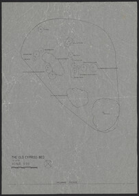
Plan, The Old Cypress Bed, 1987-1993
(1) Plant plan dated 15.8.1987 on tracing paper, and plan of bed only. (2) Site inventory and analysis Group 3 Parks and Gardens III August 1993, on tracing paper. (3) Rough plant plan in pencil.gardens, cypress, burnley gardens 150 year anniversary -
Healesville Sanctuary Heritage Centre
Newspaper - Cutting, Yarra Valley news, Another Lyrebird Aviary, 4 August 1970
Second aviary for lyrebirds on the original aviary site. It will have only one bird with the plan to acquire another for matingphotocopynon-fictionSecond aviary for lyrebirds on the original aviary site. It will have only one bird with the plan to acquire another for mating 1970s -
![Booklet, Historic Buildings Preservation Council, Register of Historic Buildings [Victoria] 1982, 1982](/media/collectors/4f729f5697f83e03086015b8/items/6656e4f0cf65d0fdbb6d865f/item-media/66834abcfc20ebe8ca2a060d/item-fit-380x285.jpg) Greensborough Historical Society
Greensborough Historical SocietyBooklet, Historic Buildings Preservation Council, Register of Historic Buildings [Victoria] 1982, 1982
The Register of Historic Buildings was set up in 1974 and is added to or amended by the Minister for Planning on the recommendation of the Historic Buildings Preservation Council. This version 1982.21 pages of duplicated typescriptnon-fictionhistoric buildings victoria, heritage sites -
 University of Melbourne, Burnley Campus Archives
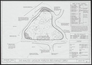
Plan, Jennifer Young, Grevillea Robusta Bed Burnley Campus, 2006
(1) Site Analysis by Jennifer Young, March 2006. (2) Plant Survey by Jennifer Young, March 2006. (3) Plant Plan - photocopy of rough hand-drawn planjennifer young, grevillea robusta, burnley horticultural college, landscaping, soil types -
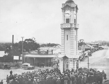 Ringwood and District Historical Society
Photograph, Opening of clock tower by Mayor W. Mackinlay in August 1928
Age (Melbourne, Vic. : 1854 - 1954), Monday 6 August 1928, page 9 ________________________________________ RINGWOOD WAR MEMORIAL CLOCK TOWER UNVEILED A CIVIC CEREMONY. The people of Ringwood have erected a beautiful stone clock tower at a cost of £1797, as a memorial to those who served in the war. The unveiling ceremony was performed by the mayor of Ringwood (Cr. W. Mackinlay) on Saturday. “Bleak conditions with showers intervening prevailed at Ringwood on Saturday afternoon, when the unveiling ceremony of the soldiers' memorial clock tower, performed by the mayor (Cr. W. Mackinlay) took place in the presence of a Iarge and representative gathering. The ceremony was solely a civic one. A majority of members of the local branch of the R.S.S.I.L.A. had wished that Sir John Monash be invited to take a prominent part in the proceedings, but the trustees elected otherwise. The Salvation Army band from Box Hill rendered suitable music, while Sergeant E. P. Taylor (37th Battalion, A.I.F) sounded the Reveille and The Last Post impressively. Among those present were Mr. Edgar, M.L.C., the vicar of Ringwood (Rev. E. E. Robinson), Rev. G. McLaren (Methodist), the memorial trustees (Cr. J. B. McAlpin, Messrs, J. W. Barrett, A. H. Locke, J. A. Williams and A. G. Ashley). The last two mentioned are president and honorary secretary respectively of the local branch of the R.S.A. Soldier delegates from Camberwell and Mitcham were also present. At the outset the mayor said a few words would not be amiss concerning why the memorial had been so long delayed in being erected. In September, 1919, a public committee was formed, with Mr. A. V. Greenwood as chairman, to consider the erection of a suitable memorial to the soldiers. Among the more important suggestions had been the building of a hall and clubrooms on land generously offered by Mr. R. W. Dawes. This project had been abandoned, also the proposed erection of a huge memorial building, at a cost of £5000, on the site of the present town hall. As two years had passed without anything of a definite nature eventuating it was decided to elect five trustees, comprising three citizens and the president and secretary of the Returned Soldiers' Association with full power to act. In all propositions the trustees had been faced with financial difficulties, but about the time of the completion of the plans of the memorial tower Ringwood became a borough, and the new council was appealed to, and provided £500 to make the erection of the memorial possible. The architect, (Mr. H. Norris) had refused to take anything beyond out-of-pocket expenses (£16), while the engineer (Mr. Lucas) had saved a goodly sum by supervising the work. The total funds at the disposal of the trustees, including the council's donation, was, in round figures £1807. The tower complete would cost £1690; honor roll, £77, and fees paid for various designs had amounted to £30. The total expenditure was £1797, leaving a credit balance of £10. Before the unveiling the mayor, in again addressing the citizens, said he deemed it a privilege to perform such a task in connection with so splendid a memorial. The citizens had erected it as an expression of heartfelt gratitude in memory, first of all, of those heroes who gave not only their services, but their lives, when the call came in the common cause of right and liberty, upon which the British Empire was built. This memorial was also the tribute of the citizens in a degree of appreciation to those men who so un-selfishly and ungrudgingly volunteered their services in the Great War. The memorial, while commemorating the glorious deeds of Australian manhood, was not intended, in any sense, as a glorification of war. The memorial would tend to bring to one's mind the blessing of peace in contrast to the curse of hostilities. They were gathered there that afternoon to do honor to all those who volunteered for service to the Great War, but they wished to assure the friends and relatives of those who paid the supreme sacrifice of their sincere sympathy and trust. If ever in the future this fair southern land of ours was threatened by an invader he felt sure that Australian manhood would not hesitate to rally to the call to duty and defend the freedom of their country. Following prayer by Rev. G. McLaren (Methodist), the memorial clock tower was unveiled, the acting mayoress (Mrs. Mackinlay) cutting the cord, after which the making over of the memorial to the borough council took place, the president of the local branch of the R.S.A. (Mr. J. A. Williams) stating he had pleasure in accepting the key on behalf of the trustees. As the council was the permanent governing body the key would be handed back to the mayor, the memorial being given into the safety and custody of the council. During the proceedings the hymns O God, Our Help in Ages Past and Lest We Forget were rendered, the choirs of various denominations joining in the singing. Benediction was pronounced by the vicar of Ringwood (Rev. E. E. Robinson).” Black and white photograph (2 copies- one original mounted on cardboard backing)Written on rear of backing of original: "Opening of clock tower by Mayor W. Mackinlay, 4.8.1928." Written on back of copy" "Mayor Mackinlay dedicating Ringwood clocktower in original position at end of Warrandyte Rd. 1928. Maroondah Hwy on right."