Showing 1797 items matching " settlement"
-
 Ballarat Heritage Services
Document, Helen Doyle & Context Pty Ltd, Moyne Heritage Study Stage 2 Vol 2, 2006
141 page heritage studymoyne, minhamite, port fairy, mt shadwell, mt rouse, mt napier, mt eccles, tower hill, dhauwurdwurrung, djabwurrung, giraiwurrung, caramut, james atkinson, special survey, william rutledge, yangery, land selection act, closer settlement, soldier settlement, framlingham, lime burning, atkinson’s belfast survey, belfast, killarney, crossley, aboriginal protectorate, lake condah, hexham, hexham common school, koroit convent, hurling, mile posts, kirkstall, ballyhurst, dundonnell, curdievale, ballangeich, hawkesdale, irish, scottish, aborigines, tower hill cemetery, st brigid’s catholic church -
 Ballarat Heritage Services
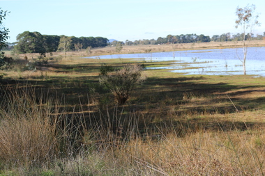
Photograph - Digital photograph, Dorothy Wickham, Winter's Swamp, Ballarat, January to April 2014
Study of Winter's Swamp commissioned by BEN and completed by BHS. The swamp was named after one of the first European settlers in the district. Winter Swamp LAT -37 32 LONG 143 47, Parish of Dowling Forest, County of Grenville Winter Swamp, on the southwest corner of Ballarat West Town Common, was not included in the original proclamation of the Common in 1861. However, being marshland, it was not considered suitable for grazing, so was added to the Common soon after 1861. Winter Swamp is a large wetland with native and exotic pasture significant for wildlife. John Winter (Jock) was born in Berwickshire, Scotland. He married Janet Margaret Irving the daughter of Robert Irving, advocate, Bonshaw, Dumfries, Scotland. Winter died in Ballarat in 1875 and was buried at the Ballaarat Old Cemetery. He took up the run Bonshaw from 1841; Leigh River Buninyong 1842-46; Junction, Delatite, March 1851 to September 1862; with sons: Carag Carag and Corop, April 1857 to September 1872; Colbinabbin and Stewart’s Plains, April 1857 to December 1872; St Germains February 1867 to March 1871. (The name became Winter-Irving in 1890). Mr John Winter, who died on August 22 at the age of 72, was a man of some note it the mining community of Ballarat. He was a self-made man, and one of our oldest colonists, it being over a quarter of a century age since he took up county about Ballarat and settled at Bonshaw. He died very rich. It is calculated that if he had retained an interest in all his runs, his income must have been not less than £10,000 or £50,000 a year. Some eight or ten years ago he sold his Bonshaw pre-emption to the Bonshaw Gold mining Company for £20,000, and a few years later the ground belonging now to Winter's Freehold Company brought him £50,000 more, the payment being made at the requisition of the deceased in sovereigns. In these relations Mr. Winter has been closely identified with the mining industry at Ballarat. The deceased was a native of Lauder, in Berwickshire, and landed in Victoria several years before the gold discovery.The principle task of this project was the delivery of a report outlining the history of European settlement in the Skipton and Cardigan/Ballarat districts as pertinent to the use of and impact on the natural environment of the two reserves Skipton Common and Winter Swamp. The report was delivered in digital form only. The report, upon completion, was presented to the Network’s Committee in order to discuss the project. The report identified and described the uses of Skipton Common and Winter Swamp, and their impacts. In particular, this report examined farming/grazing (official and informal), mining, vegetation removal (including the removal of woodlands for timber, grasslands for pasture improvement) & use of riparian areas for access to water and timber removal. Recording the more benign and environmentally friendly uses such as picnicking, community activities, nature walks and the roles of organisations such as Field Naturalists’ and Bird Observers’ clubs, school and scout/guide groups will be relevant in helping to depict overall community attitudes towards the reserves; e.g.: has the Common generally been viewed as little more than a grazing paddock and fire hazard; has Winter Swamp always been the unknown natural asset that seems to have been its lot for at least the past 40 years? In this regard, the more contemporary history of actions surrounding the use and management of the reserves is of particular interest, in view of the extant evidence at both reserves; e.g. the actions of the Shire of Ballarat in the 1980s in establishing Winter Swamp as something of a competitor to Lake Wendouree but with a more environmental bent (although almost none of the plants used are indigenous species, but that is part of the story); the trotting track constructed on Skipton Common in the 1960s following representations to Premier Henry Bolte and the cropping of the western section of the Common to raise funds for the town’s new swimming pool, the fertilizing of the land putting an end to the native grassland vegetation. There are obviously multiple sources of information to source in preparing the report, however sources that the contractor is specifically requested to consult are the Skipton Historical Society, the former Skipton Common managers (specifically Graeme Pett), the Cardigan Windermere Landcare Group and the Learmonth Historical Society (believed to hold many of the former Shire of Ballarat’s records pertaining to the Council’s role as the Committee of Management for both Winter Swamp and the Ballarat West Town Common – Winter Swamp was split between 2 separate Crown Land tenures). The contractor is also encouraged but not required to utilise community newsletters, such as the Skipton Community Newsletter, to publicise and seek information about the project. Skipton Historical Society (Mary Bradshaw) contacted on Thursday 12 June 2.30pm. Mary lived on a farm out of Skipton but is currently living in the township. She remembers walking along the creek of the Common especially in spring and autumn in bare feet and that it was a very pretty place. There were a few snakes around the waterway in summer. People put cows and a couple of horses on the commonage to graze. Graeme Pett has always lived close to the Common and would know a lot about it. Other possible contacts would be Nicole Petress, Secretary of the Progress Association, and the Corangamite Council, Camperdown. Digital images of Winter's Swampwinter's swamp, ballarat, john winter, ballarat environmental network, mullawullah -
 Ballarat Heritage Services
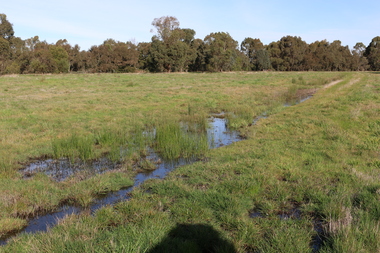
Photograph - Digital photograph, Winter's Swamp surrounds, April 2014
The swamp was named after John (Jock) Winter. John Winter (Jock) was born in Berwickshire, Scotland. He married Janet Margaret Irving the daughter of Robert Irving, advocate, Bonshaw, Dumfries, Scotland. Winter died in Ballarat in 1875 and was buried at the Ballaarat Old Cemetery. He took up the run Bonshaw from 1841; Leigh River Buninyong 1842-46; Junction, Delatite, March 1851 to September 1862; with sons: Carag Carag and Corop, April 1857 to September 1872; Colbinabbin and Stewart’s Plains, April 1857 to December 1872; St Germains February 1867 to March 1871. (The name became Winter-Irving in 1890). Mr John Winter, who died on August 22 at the age of 72, was a man of some note it the mining community of Ballarat. He was a self-made man, and one of our oldest colonists, it being over a quarter of a century age since he took up county about Ballarat and settled at Bonshaw. He died very rich. It is calculated that if he had retained an interest in all his runs, his income must have been not less than £10,000 or £50,000 a year. Some eight or ten years ago he sold his Bonshaw pre-emption to the Bonshaw Gold mining Company for £20,000, and a few years later the ground belonging now to Winter's Freehold Company brought him £50,000 more, the payment being made at the requisition of the deceased in sovereigns. In these relations Mr. Winter has been closely identified with the mining industry at Ballarat. The deceased was a native of Lauder, in Berwickshire, and landed in Victoria several years before the gold discovery. BHS were commissioned by Ballarat Environment Network for a project on Winter's Swamp and Skipton Common. Winter's Swamp was part of Ballarat West Common. The principle task of this project was the delivery of a report outlining the history of European settlement in the Skipton and Cardigan/Ballarat districts as pertinent to the use of and impact on the natural environment of the two reserves Skipton Common and Winter Swamp. The report was delivered in digital form only. The report, upon completion, was presented to the Network’s Committee in order to discuss the project. The report identified and described the uses of Skipton Common and Winter Swamp, and their impacts. In particular, this report examined farming/grazing (official and informal), mining, vegetation removal (including the removal of woodlands for timber, grasslands for pasture improvement) & use of riparian areas for access to water and timber removal. Recording the more benign and environmentally friendly uses such as picnicking, community activities, nature walks and the roles of organisations such as Field Naturalists’ and Bird Observers’ clubs, school and scout/guide groups will be relevant in helping to depict overall community attitudes towards the reserves; e.g.: has the Common generally been viewed as little more than a grazing paddock and fire hazard; has Winter Swamp always been the unknown natural asset that seems to have been its lot for at least the past 40 years? In this regard, the more contemporary history of actions surrounding the use and management of the reserves is of particular interest, in view of the extant evidence at both reserves; e.g. the actions of the Shire of Ballarat in the 1980s in establishing Winter Swamp as something of a competitor to Lake Wendouree but with a more environmental bent (although almost none of the plants used are indigenous species, but that is part of the story); the trotting track constructed on Skipton Common in the 1960s following representations to Premier Henry Bolte and the cropping of the western section of the Common to raise funds for the town’s new swimming pool, the fertilizing of the land putting an end to the native grassland vegetation. There are obviously multiple sources of information to source in preparing the report, however sources that the contractor is specifically requested to consult are the Skipton Historical Society, the former Skipton Common managers (specifically Graeme Pett), the Cardigan Windermere Landcare Group and the Learmonth Historical Society (believed to hold many of the former Shire of Ballarat’s records pertaining to the Council’s role as the Committee of Management for both Winter Swamp and the Ballarat West Town Common – Winter Swamp was split between 2 separate Crown Land tenures). The contractor is also encouraged but not required to utilise community newsletters, such as the Skipton Community Newsletter, to publicise and seek information about the project. Skipton Historical Society (Mary Bradshaw) contacted on Thursday 12 June 2.30pm. Mary lived on a farm out of Skipton but is currently living in the township. She remembers walking along the creek of the Common especially in spring and autumn in bare feet and that it was a very pretty place. There were a few snakes around the waterway in summer. People put cows and a couple of horses on the commonage to graze. Graeme Pett has always lived close to the Common and would know a lot about it. Other possible contacts would be Nicole Petress, Secretary of the Progress Association, and the Corangamite Council, Camperdown. Mary can’t remember any photos in the Skipton Historical Society that pertain to the Common. Digital photos of Winter's swamp surrounds, later known as Mullawullah.winter, winter's swamp surrounds, winter's swap, john winter, ballarat environmental network, ballarat, mullawullah -
 City of Ballarat Libraries
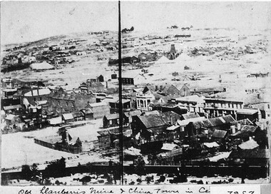
Photograph - Card Box Photographs, View from East Ballarat Fire Station tower circa 1866
Old Llanberris Mine and Chinatown in the centre.east ballarat fire station, llanberris mine, chinese settlement, mining, buildings, commerical -
Unions Ballarat
Victorian history and politics : European settlement to 1939 : a survey of the literature, Monie, Joanna, 1982
Literature review. Contents - Volume 2 Transport and Communications Natural Disasters Women Immigration and Demography Aborigines Social Welfare Health Education Libraries and Museums Leisure Press The Administration of Justice Bushrangers AppendixRelevant to the history of Victorian state history, social customs and politics.Paperback book. Front cover: red background; picture of horses and carts - historical setting; white and black text. Back cover: picture of Bignell's New Hotel with flag.Front cover: Title and author name. transport, communications, natural disasters, women, immigration, demography, aboriginals, welfare, health, libraries, museums, leisure, press, law, law enforcement, bushrangers -
 Hume City Civic Collection
Booklet, Sunbury, 1987
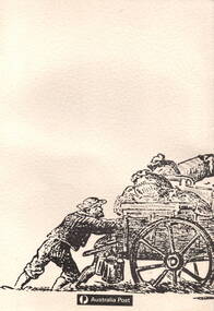
The booklet gives a brief outline of Sunbury's history from European settlement to the late 20th century.Two identical paperback publications with a cream rippled cardboard cover with a sketch on the front of a two diggers pulling a horse-drawn cart with mail and other items. The title 'Sunbury' is embossed on the cover. non-fictionThe booklet gives a brief outline of Sunbury's history from European settlement to the late 20th century. australia post, post office, sunbury post office -
 Hume City Civic Collection
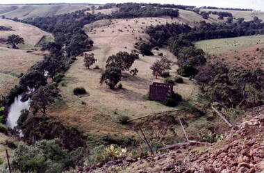
Photograph, Bulla Mill
The waterway is the Deep Creek at Bulla. Originally this was the site of one of the earliest mills in the district.In the early days of European settlement a number of mills were established on the banks of both the Jackson and Deep Creeks in Bulla and Sunbury.A coloured photograph of a valley surrounded by hills with the ruins of a stone building on the horseshoe bend of the creek. deep creek, mills, bulla bulla -
 Hume City Civic Collection
Booklet - History Reference Book, Sunbury: Pioneer to Pop Festivals, c1980
A short local history covering 140 years of European Settlement in Sunbury from 1836 to 1972. The booklet was produced by Dr. John Patterson with help from local Sunbury people.A paperback book of 58 pages with text and black and white photographs stapled together with a cardboard cover and a coloured reproduction of a painting by George Rowe of an early race meeting in Sunbury. non-fictionA short local history covering 140 years of European Settlement in Sunbury from 1836 to 1972. The booklet was produced by Dr. John Patterson with help from local Sunbury people.local history, sunbury, dr. john patterson -
 Tatura Irrigation & Wartime Camps Museum
Book, Ken Inglis et al, Dunera Lives Profiles, 1941
Volume 2 of Dunera Lives follows the paths of a selection of Dunera Boys from their early lives before and during the Nazi years, through their arrival in Britain or the Straits Settlements in search of a safe haven, to their arrest as enemy aliens and subsequent deportation and incarceration in camps in Australia. Then, as free men, they start new lives in many parts of the world.While covered book with black writing. Front: book title, photograph of a camp hut and authors names at bottom; Spine: title and authors; back cover: Photograph of several of the Dunera Boys.non-fictionVolume 2 of Dunera Lives follows the paths of a selection of Dunera Boys from their early lives before and during the Nazi years, through their arrival in Britain or the Straits Settlements in search of a safe haven, to their arrest as enemy aliens and subsequent deportation and incarceration in camps in Australia. Then, as free men, they start new lives in many parts of the world.dunera boys, ken inglis, bill gammage, seumas spark, jay winter, carol bunyan, hmt dunera, queen mary -
Southern Sherbrooke Historical Society Inc.
Book - Local History, Longman Cheshire Pty Ltd, Story Of The Dandenongs, First published 1959, thisa copy reprinted 1982
pp.xv, 415, hardback, appendices, index of names. History of exploration & development,local government & services and the townships of the Dandenong Ranges, 1838-1958.dandenong ranges, local government, white settlement -
 Southern Sherbrooke Historical Society Inc.
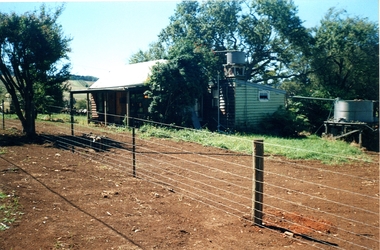
Information folder - Madigan Cottage
The buildings are probably rare remnant examples of their type in the local area and as such are significant to the settlement of Menzies Creek. The dwelling is significant as a longstanding marker of the Madigan family who were original settlers in the area. Its retention in its site close to the road boundary expresses and maintains a connection with early settlement and rural lifestyles in Menzies Creek over the last century. The old shed is of interest as a local example of bush construction, particularly in context with the cottage and farm environs. Without the life of the farm and other elements presumed now gone, its value is lessened.Folder containing information pertaining to the history of Madigan Cottage, Menzies Creek. NB: the shed was demolished in November 2001 and the cottage burned down sometime later. Contents:- Letter, Southern Sherbrooke Historical Society to Shire of Yarra Ranges, dated 9th March 2001, re. sale of property and need for it to be included in shire's Heritage Study. -Letter, shire to society, dated 20th March 2001, reply to above. -Letter, shire to society, dated 15th May 2001, follow-up to above, requesting more information. -Letter, society to shire, dated 30th May 2001, responding to above and including a copy of information previously sent to Chris Johnston, Heritage Study consultant. -Letter, society to shire, undated, noting intention to lodge an objection to proposed application for development on site. -Letter, shire to society, dated 22nd October 2001, advising of consultation meeting. -Yarra Ranges Shire Heritage Study Place Nomination form for Madigan Cottage, prepared by Marian Matta, includes nine colour photos and diagram showing where photos were taken from. -Black and white copies of photos. -A3 copy of real estate advertisement, "Mount Evergreen Estate" dated 21st April 1924. -A3 map showing proposed resubdivision boundary variation, drawn up for Mr. P. Melville, undated but 1990s. -Copy of application for a planning permit, dated 6th August 2001, including letter by Nick Jonkers describing proposed new buildings, site map showing current vegetation, letter re. proposed removal of vegetation, subdivision plan dated March 1998, and larger scale map printed from shire website on 10th August 2001. -5 A3 sheets showing site and house plans drawn up for Mr & Mrs N. Jonkers, dated July 2001.madigan cottage, menzies creek, madigan family, mount evergreen, patrick madigan -
Moorabbin Air Museum
Document (Item) - Section of the Aircraft Industry Award 1980 Concerning Settlement of Disputes, Aircraft Industry (Domestic Airlines) Award 1980
-
 Ballarat Tramway Museum
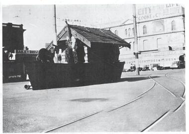
Photograph - Digital image - Museum of Victoria Grenville St shelter, 1939
Image is of the decorated tram stop shelter in 1938 at Grenville St. The shelter has been decorated with an outline of a boat. Bailey Bros Butchers in the background.Yields information about the centenary of settlement in Ballarat during 1939Digital image obtained from the Museum of Victorian websiteshelters, ballarat centenary celebrations, grenville st, tramways -
 Otway Districts Historical Society
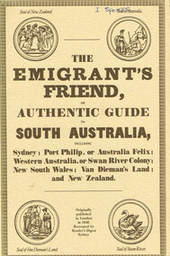
Book, Reader's Digest Services Pty Limited, The emigrant's friend, or authentic guide to South Australia, 1974
This book is a replica of a booklet printed in the United Kingdom. In 1848, when it was published in London as a guide to prospective emigrants, 23,904 people left the United Kingdom for the Australian colonies and New Zealand. In 1847, with the failure of potato crops threatening famine in Ireland and growing political unrest at home, the British Government had once again encouraged emigration by offering free passage to candidates of 'good character'. Immigration, particularly by the labouring classes, was intended to relieve both the overburdened Mother Country and the colonies which had acute labour shortages. The booklet gives some history of each colony as well as the sale of lands, mines and mining, produce, the price of living, wages and, generally, the situation. The emigrant's friend, or authentic guide to South Australia including Sydney: Port Phillip, or Australia Felix: Western Australia, or Swan River Colony: New South Wales: Van Dieman's Land: and New Zealand. Reprint. Reader's Digest Services Pty Limited; Surrey Hills (NSW); 1974. 40 p. Soft cover. australia; colonies; settlement; nsw; port phillip; western australia; south australia; van dieman's land; new zealand; emigration; immigration; -
 Heytesbury District Historical Society Inc.
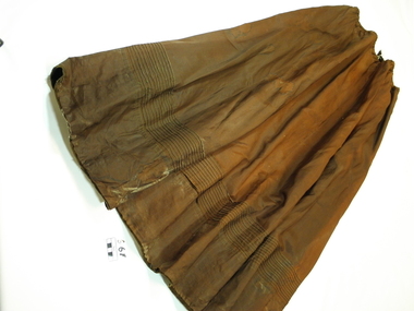
Clothing - Ladies Skirt, Hand made
This skirt was probably worn of a daytime by a farmer's wife in the Timboon area early in the 20th Century.This long rust brown taffeta circular skirt is faded, worn and torn. It has 13 rows of machine stitching around bottom, 24cms from edge. It has an elastic waist and short zip at back of waist.clothing, women, needlecraft, skirt, early settlement, timboon -
 Bendigo Historical Society Inc.
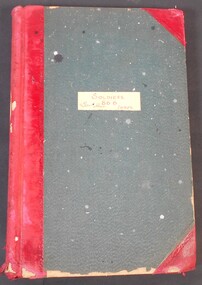
Administrative record - Soldiers Index 866, 28/06/2007
Soldiers Index 866, an alphabetic ledger of soldier's names; with CS & DS on the spine. Red and green book, with red spine and corners. Unknown duration of entries. Unknown location.soldier settlement, land sales -
 Kew Historical Society Inc
Legal record - The Indenture, Crown Portion 86, otherwise known as 'The Morgan Deed', 1852 (and later)
This indenture once formed part of the City of Kew's Municipal Collection. Cr. W.D. Vaughan in his history 'Kew's Civic Century' (1960) records on page 194 that: "The original deed of conveyance of the land being all of Crown Portion 86, Kew, purchased by John Quick, James Venn Morgan, Samuel Derrick and William Derrick was presented by the Historical Society of Victoria on behalf of Mrs Fryer, a daughter of the later J.V. Morgan, to the [Kew] Council on August 5, 1941. Crown Portion 86, comprised all the land between Cotham Road and High Street to an alignment opposite the east boundary of Glenferrie Road. On it the first residential house was built by Mr. J.V. Morgan in 1852." Following the donation, the Indenture was surrounded by other original related text and explanatory notes and framed. The resulting framed documents are the largest framed objects in the collection.The Indenture and the accompanying contextual documents are some of the most historically significant manuscripts to have survived since the settlement of Kew in the 1850s. They provide a link to Kew's most famous pioneering families.Framed 1952 Indenture recording the sale of land in Kew to pioneering Kew families.james venn morgan, john quick, william derrick, samuel derrick, kew (vic) - history, kew (vic) - pioneers, samuel watts, kew (vic.) — municipal collection -
Kew Historical Society Inc
Archive (Sub-series) - Subject File, Kew Historical Society, GARDINER, John, 1958
Various partiesReference, Research, InformationSecondary Values (KHS Imposed Order)Subject file containing photocopied notes, articles and a map relating to the Hawthorn pioneer, John Gardinerhistory - european settlement - squatters - hawthorn - melbourne - victoria, john gardiner -- pioneerhistory - european settlement - squatters - hawthorn - melbourne - victoria, john gardiner -- pioneer -
 Kew Historical Society Inc
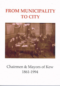
Book, From Municipality to City : Chairmen & Mayors of Kew 1861-1994, 2019
From Municipality to City: Chairmen & Mayors of Kew 1861-1994 is the result of a collaborative history project completed by members of the Kew Historical Society. Th text includes a contextualised series of illustrated biographical and autobiographical profiles of the former civic leaders of Kew. The profiles explore the political, social, cultural and economic history of Kew from the earliest years of European settlement to the amalgamation of Kew into the City of Boroondara in 1994.110 pages : illustrations, portraits ; 29 cm.non-fictionFrom Municipality to City: Chairmen & Mayors of Kew 1861-1994 is the result of a collaborative history project completed by members of the Kew Historical Society. Th text includes a contextualised series of illustrated biographical and autobiographical profiles of the former civic leaders of Kew. The profiles explore the political, social, cultural and economic history of Kew from the earliest years of European settlement to the amalgamation of Kew into the City of Boroondara in 1994.kew (vic.). council -- history, mayors -- victoria -- kew -- biography, kew (vic.) -- history -
 Kew Historical Society Inc
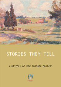
Book, Stories They Tell : A history of Kew through objects, 2022
'Stories They Tell : A history of Kew through objects' explores diverse narratives from European settlement to the first decades of the twenty-first century. These stories use as their starting point artworks, texts and artefacts from the nationally significant collection of the Kew Historical Society. Limited to 100 copies.117 pp : illustrated : Appendices Chapters: Preface / Robert Baker p4. The collection / Robert Baker p5. Cartwheel penny / Robert Baker p6. Creek and old watering stage / David White p10. John Carson: Mayor 1863–4 1 / Julie King p4. Wedding dress / Suzanne McWha p18. Back to Kew 1875 / Judith Scurfield p22. Barnard’s clock / Margaret Robinson p26. Denbigh quilt / Suzanne McWha p28. Fragments of art decoration / Robert Baker p32. Mr Richardson’s sock / Felicity Renowden p36. Kew Volunteer Fire Brigade / David White p38. Kew Where We Live / Judith Scurfield p42. [MMBW} Detail Plan No. 1580 / Judith Scurfield p46. Adeney Avenue / Suzanne McWha p50. Young Workers’ Patriotic Guild / Margaret Robinson p54. Roll of Honor [Thomas Rand] / Robert Baker p56. Alice Anderson in her tourer / Felicity Renowden p60. Kew War Memorial / David White p62. Beaded dance dress / Suzanne McWha p 66. The great flood of 1934 / Desley Reid p68. Depression-era toolbox / Robert Baker p72. War Savings Street / Julie King p74. Kew Public L.ibrary / Suzanne McWha p78. Signature supper cloth / Desley Reid p82. View from the garden of Rockingham / Desley Reid p86. Cr Marie Dalley / Felicity Renowden p90. Centenary of Kew / Robert Baker p94. Doris Dickinson’s gown / Julie King p98. [Model Dairy] Milk bottles / Robert Baker p100. Kew Civic Centre / David White p102. Bicentennial tapestries / Margaret Robinson p106. Crest of the City of Kew / Desley Reid p110. Town Crier [outfit] / Desley Reid p112. Acknowledgements p114. List of works p115.non-fiction'Stories They Tell : A history of Kew through objects' explores diverse narratives from European settlement to the first decades of the twenty-first century. These stories use as their starting point artworks, texts and artefacts from the nationally significant collection of the Kew Historical Society. Limited to 100 copies.collection -- kew historical society, museum catalogues, henty family, cartwheel pennies, kew lunatic asylum, patchwork quilts, john carson, george bouchier richardson, gb richardson, coombs family, james dannock, back to kew 1875, francis barnard, denbigh family, cullis hill & co, ordsall, southesk, kew volunteer fire brigade, jfc farquhar, henry kellett, mmbw detail plan 1580, william nicholls anderson, young workers patriotic guild, roll of honor -- town of kew, alice anderson, kew war memorial, flapper dresses, fairfield bridge, chandler highway bridge, warren trestrail, furniture -- 1930s, war savings streets, kew library, children's libraries, voluntary aid detachments - kew (vic.), rockingham, james govett, centenary of kew, mayoresses -- kew (vic.), model dairy -- kew (vic.), doris dickinson, crests -- city of kew (vic.), town criers -- kew (vic.), joy stewart, australian bicentennial -- kew (vic.), kew civic centre, ak lines mcfarlane marshall, adeney avenue -- kew, wwi -
Kew Historical Society Inc
Collection, Floods in North Kew (Series), 1929–1934
Flooding of the Yarra Valley, including that section of the Yarra bordering Kew and Kew East in the north and west of the municipality, was a regular occurrence. Extreme flood events of the Yarra River are recorded to have occurred in 1891, 1901, 1916, 1923 and 1934. The Municipality of Kew's response to these floods was to enact planning decisions restricting residential development in flood prone areas following the floods of 1916, 1921 and 1934. While floods continued after the development of the Upper Yarra Reservoir (construction 1948-57), the regularity and extent of these inundations diminished. Natural disasters had an impact on the development and settlement of Melbourne and its suburbs. Flooding in the Melbourne region was a regular event in the nineteenth and for most of the twentieth centuries. Changes in the impact of natural disasters could occur due to a number of factors. This collection of small snapshots, mostly taken from Kellett Grove in North Kew, provide provenanced evidence of flooding in the area before the development of the unnatural flood barrier that is the Eastern Freeway.Collection of 16 monochrome photographs, annotated on verso by different hands, of the flooding of the River Yarra in North Kew in the third and fourth decades of the twentieth century [1920s & 1930s]. Individual photos include the dates of different floods. Many of the photos were taken from the rear of 8 Kellett Grove; a house still extant in 2023yarra river -- north kew, floods -- yarra valley, floods -- north kew, floods -- 1929, floods -- 1934, natural disasters -- kew -
 Kew Historical Society Inc
Book, Libraries Board of South Australia, Narrative of a Survey of the Coasts of the Intertropical and Western Coasts of Australia performed between the Years 1818 and 1822 in two volumes (Vol.1), 1969
This two-volume work by Captain Phillip Parker King (1791–1856) was published in 1827, and describes the Royal Navy's 1817–22 surveying expedition to chart the coastal regions of Australia. King carried out the surveys in two successive ships, the Mermaid, which was declared unseaworthy in 1820, and the newly commissioned Bathurst. He worked on the charts, which were published by the Hydrographic Office, for two years after his return to England. He was made a Fellow of the Royal Society, and later undertook a similar surveying voyage, in which he was accompanied by Captain Fitzroy on the Beagle, around the coast of South America. The book is derived from the author's journal, and describes not only the voyages but also the towns and settlements of the region. Volume 2 continues the survey along the north and west coasts of Australia, and contains an appendix describing winds, currents, ports and islands.Facsimile Editions No.30. 2 v. : illus., fold. charts, tables. non-fictionThis two-volume work by Captain Phillip Parker King (1791–1856) was published in 1827, and describes the Royal Navy's 1817–22 surveying expedition to chart the coastal regions of Australia. King carried out the surveys in two successive ships, the Mermaid, which was declared unseaworthy in 1820, and the newly commissioned Bathurst. He worked on the charts, which were published by the Hydrographic Office, for two years after his return to England. He was made a Fellow of the Royal Society, and later undertook a similar surveying voyage, in which he was accompanied by Captain Fitzroy on the Beagle, around the coast of South America. The book is derived from the author's journal, and describes not only the voyages but also the towns and settlements of the region. Volume 2 continues the survey along the north and west coasts of Australia, and contains an appendix describing winds, currents, ports and islands.australia -- description and travel -- to 1850., hydrography -- australia., natural history -- australia. -
 Kew Historical Society Inc
Book, Libraries Board of South Australia, Narrative of a Survey of the Coasts of the Intertropical and Western Coasts of Australia performed between the Years 1818 and 1822 in two volumes (Vol.2), 1969
This two-volume work by Captain Phillip Parker King (1791–1856) was published in 1827, and describes the Royal Navy's 1817–22 surveying expedition to chart the coastal regions of Australia. King carried out the surveys in two successive ships, the Mermaid, which was declared unseaworthy in 1820, and the newly commissioned Bathurst. He worked on the charts, which were published by the Hydrographic Office, for two years after his return to England. He was made a Fellow of the Royal Society, and later undertook a similar surveying voyage, in which he was accompanied by Captain Fitzroy on the Beagle, around the coast of South America. The book is derived from the author's journal, and describes not only the voyages but also the towns and settlements of the region. Volume 2 continues the survey along the north and west coasts of Australia, and contains an appendix describing winds, currents, ports and islands.Australian Facsimile Editions No.30. 2 v. : illus., fold. charts, tables. non-fictionThis two-volume work by Captain Phillip Parker King (1791–1856) was published in 1827, and describes the Royal Navy's 1817–22 surveying expedition to chart the coastal regions of Australia. King carried out the surveys in two successive ships, the Mermaid, which was declared unseaworthy in 1820, and the newly commissioned Bathurst. He worked on the charts, which were published by the Hydrographic Office, for two years after his return to England. He was made a Fellow of the Royal Society, and later undertook a similar surveying voyage, in which he was accompanied by Captain Fitzroy on the Beagle, around the coast of South America. The book is derived from the author's journal, and describes not only the voyages but also the towns and settlements of the region. Volume 2 continues the survey along the north and west coasts of Australia, and contains an appendix describing winds, currents, ports and islands.philip parker king, natural history -- australia., australia -- description and travel -- to 1850. -
 Kew Historical Society Inc
Book, Oxford University Press, The Narrative of George Russell of Golf Hill with Russelliana and selected papers, 1963
Account of early pastoral settlement in Tasmania and Port Phillip focusing on the progress of the Russell family; includes observations on relations between settlers and Aborigines; account of the Black War in Tasmania; story of William Buckley, description of Port Phillip Aboriginal shelters, corroborees, missions, rapid extinction.London : Oxford University Press, 1935 469 p. : ill. map, ports., geneal. table ; 25 cm. non-fictionAccount of early pastoral settlement in Tasmania and Port Phillip focusing on the progress of the Russell family; includes observations on relations between settlers and Aborigines; account of the Black War in Tasmania; story of William Buckley, description of Port Phillip Aboriginal shelters, corroborees, missions, rapid extinction.russell family, clyde company, voyages and travels -
 Kew Historical Society Inc
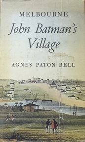
Book, Agnes P Bell, Melbourne: John Batman’s Village, 1965
A history of Melbourne, tracing its development from the riverside village founded by John Batman to the metropolis of the 1960s; includes description of Aboriginal corroborees and other early encounters with the Aboriginal inhabitants of the area.Melbourne, Vic. : Cassell Australia, 1965 xiv, 178p. : ill. (some col.), facsims., map, porto. ; 25cm. non-fictionA history of Melbourne, tracing its development from the riverside village founded by John Batman to the metropolis of the 1960s; includes description of Aboriginal corroborees and other early encounters with the Aboriginal inhabitants of the area.batman, john, 1801-1839, melbourne (vic.) -- history., settlement and contacts - colonisation - 1851- -
 Kew Historical Society Inc
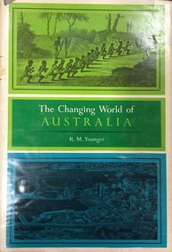
Book, Franklin Watts, The Changing World of Australia, 1963
General history with very brief mention of Aborigines.New York : Franklin Watts, 1963 vii, 253 p. ; 25 cm. non-fictionGeneral history with very brief mention of Aborigines.settlement and contacts - colonisation., settlement and contacts - ancient and early historical., politics and government - sovereignty, economic sectors - agriculture and horticulture - pastoral industry., settlement and contacts - government settlements, history - political. | settlement and contacts - settlers., australia -- history. -
 Sunbury Family History and Heritage Society Inc.
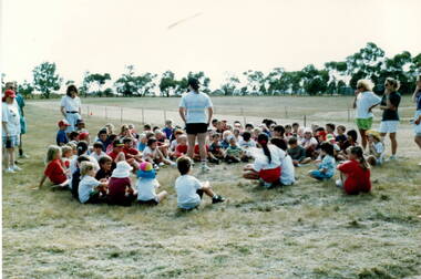
Photograph, School Sports Day
The photograph was taken on a sports day which took place at the Mickleham Sports Ground. Bulla Primary School along with Mickleham, Yuroke, Greenvale, Craigieburn and Kal Kallo competed in the completion before some of those towns became suburbs.This event took place when Bulla and the surrounding towns were still rural settlements.A coloured photograph of children sitting in a circle on the ground in an open field while a teacher is talking to thembulla primary school, mickleham, school sports meetings -
 Sunbury Family History and Heritage Society Inc.
Photograph, c 1920s
The people in the photograph had gathered at the Emu Bottom homestead in Sunbury to celebrate the installation of the fountain in the garden of the property.Emu Bottom Homestead is one of the oldest surviving homesteads which were built in the early days of European settlement in Victoria. A black and white photograph of a crowd of people at a celebration. They are gathered around a fountain. The print has been photographed from another photograph.emu bottom, fountains -
 Sunbury Family History and Heritage Society Inc.
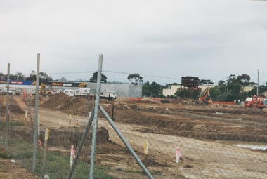
Photograph, 13 April 2000
In 2000 work commenced on the further development of railway land on the west side of Sunbury station for the construction of commercial and entertainment facilities. Prior to this time the land had been undeveloped and was often used to accommodate visiting circus troupes. Cereal storage silos also occupied this area for some time. The development of this area has been a reflection of the rapid expansion of settlement within Sunbury and surrounding areas that occurred during the early years of the twentieth century.A coloured photograph of a fenced off area undergoing development with earthmoving equipment and trucks in operation and some commercial buildings visible in the middle distance.sunbury railway station -
 Sunbury Family History and Heritage Society Inc.
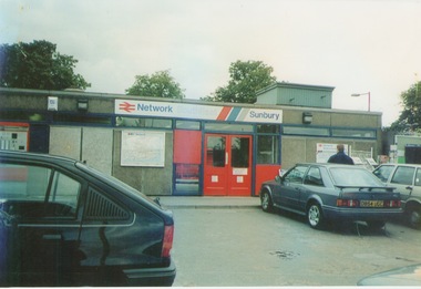
Photograph, September 1996
The photograph shows the railway station at Sunbury in Surrey in the United Kingdom. The town of Sunbury in Victoria was named after the English township of Sunbury-on-Thames in Middlesex by the Jackson Brothers who took up land in Sunbury, Victoria. The area was originally known as Koora Kooracup by the Wurundjeri people.Sunbury in Victoria like many other settlements in Australia were given names of towns in the United KingdomA coloured photograph of a railway station with three cars parked outside the building, which has grey walls and scarlet and blue trims. There are framed maps and notices on the exterior walls.