Showing 561 items
matching october 8
-
 Halls Gap & Grampians Historical Society
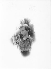
Photograph - B/W, C Oct 1986
The photo was taken at the Halls Gap Wildflower Show in October 1986 (perhaps at the parade held that year?).The photo shows a young boy (perhaps 8 or 9 yo) surrounded by adults, as can be seen by arms and shoulders. The image has been altered to show an uneven cameo image of the boy.events, wildflower show -
 Eltham District Historical Society Inc
Newsletter, Newsletter, No. 142 January 2002
Contents: • Next meeting, Audio Presentation: Alan Marshall Speaking • February Meeting • 2002 Program • Nillumbik Then and Now • Eltham New Zealand • The Re-Dedication Day, Thursday 8, 2001 • Roger Bird • In Brief • Annual General Meeting The Shire of Eltham Historical Society was formed in October 1967. The first newsletter of the Society was issued May 1978 and has been published continuously ever since on a bi-monthly basis. With the cessation of the Shire of Eltham in late 1994, the Society's name was revised to Eltham District Historical Society and this name first appeared with issue No. 103, July 1995. The collection of the Society's newsletters provides a valuable resource on the history of the Society's activities, office bearers and committee members, guest speakers and subjects of historical interest pertinent to the former Shire of Eltham and the Eltham District.A4 photocopied newsletter distributed to membersnewsletter, eltham district historical society, shire of eltham historical society -
 Eltham District Historical Society Inc
Newsletter, Newsletter, No. 174 May 2007
Contents: • Next meeting, guest speaker; Kristin Otto: Yarra; A Diverting History of Melbourne’s Murky River • May Meeting • President’s Report • Pat Baddeley’s Story (continued) • Fortieth Anniversary Celebrations • Office Bearers 2007-8 • Subscriptions • Other News The Shire of Eltham Historical Society was formed in October 1967. The first newsletter of the Society was issued May 1978 and has been published continuously ever since on a bi-monthly basis. With the cessation of the Shire of Eltham in late 1994, the Society's name was revised to Eltham District Historical Society and this name first appeared with issue No. 103, July 1995. The collection of the Society's newsletters provides a valuable resource on the history of the Society's activities, office bearers and committee members, guest speakers and subjects of historical interest pertinent to the former Shire of Eltham and the Eltham District.A4 photocopied newsletter distributed to membersnewsletter, eltham district historical society, shire of eltham historical society -
 4th/19th Prince of Wales's Light Horse Regiment Unit History Room
Medal, Italy Star, abt 1945
The Italy Star was granted for operational service on land in Sicily or Italy at any time during the campaign from the capture of Pantellaria on 11 June 1943 until 8 May 1945, the date of the end of active hostilities in Europe. Eligibility The Italy Star is awarded for operational service in the Italy Campaign from 11 June 1943 to 8 May 1945. Operational service in the Aegean, Dodecanese, Greece and Yugoslavia after 11 June 1943, in Sicily up to 17 August 1943, in Sardinia up to 19 September 1943 and in Corsica up to 4 October 1943. The Medal The Italy Star is a six–pointed star of yellow copper zinc alloy. The obverse has a central design of the Royal and Imperial cypher, surmounted by a crown. The cypher is surrounded by a circlet containing the words ‘The Italy Star'. Stars issued to Australian personnel have recipient names engraved on the plain reverse. The Ribbon The Italy Star ribbon has stripes of green, white stripes and red, these being the national colours of Italy.Full size & miniature Italy StarRecipient not engravedmedal, italy star -
 Eltham District Historical Society Inc
Ledger, Eltham Road District. Assessment for the Year ending Oct. 14th, 1858, 1857c
The Eltham Roads Board was established in 1856. This is a unique significant record of early settlers in the Shire of Eltham. One of 6 early rate books. This is among the oldest items in the EDHS collection. An article in the Eltham and Whittlesea Shires Advertiser Friday 21 Nov 1941 Page 5 titled: District's Early History states: "The first rate book which is still in existence at the Shire Office is for the year ending October 14, 1858 and is probably the best record possible to indicate the development of the district. At the time properties were rated as follows: Cultivated land. 6d. per acre; pasture land, 1d. per acre: estimated annual value of buildings, etc., 6d in the (pound). The total amount of rate recorded for the year was (pounds)153/14/8. Properties were described as being situated at Lower Plenty, Yarra Yarra, Eltham, Lower Eltham, Kangaroo Ground, Yarra Flats, Diamond Creek and the Yarra."Ledger with printed columns: Number, Name of Occupier, Description, Where situated, Cultivated land, Pasture land, Estimated annual value of buildings, Rate, Remarks. Ledger filled out by hand with 152 entries (not alphabetically arranged). A number of blank pages are included. Copy re-bound in green hard leather look card by Arnall & Jackson Pty Ltd Brunswick, 1968 Inside cover includes a compliments slip taped to the cover from Arnall & Jackson Pty Ltd. with handwritten inscription: "Ian, I hope the hysterical society doesn't get historical about this". Organised 1968 I. Maynard Inside cover includes pasted printed note: RATE OF ASSESSMENT AS FOLLOWS: Cultivated land 6d per acre Pasture land 1 per acre Estimated Annual Value of Buildings, &c., 6d. in the Pound eltham roads board, rate book, rate payers, transaction, pioneers, settlers, 1858, assessment ledger, eltham road district, public records office victoria (prov), rate books, shire of eltham archives -
 Eltham District Historical Society Inc
Ledger, Eltham Road District. Assessment for the Year ending Oct. 14th, 1859, 1858c
The Eltham Roads Board was established in 1856. This ledger includes the signature of Road Board Secretary and Collector Wingrove, a significant person in Eltham's early history. This is a unique significant record of early settlers in the Shire of Eltham. One of 6 early rate books. This is among the oldest items in the EDHS collection. An article in the Eltham and Whittlesea Shires Advertiser Friday 21 Nov 1941 Page 5 titled: District's Early History states: "The first rate book which is still in existence at the Shire Office is for the year ending October 14, 1858 and is probably the best record possible to indicate the development of the district. At the time properties were rated as follows: Cultivated land. 6d. per acre; pasture land, 1d. per acre: estimated annual value of buildings, etc., 6d in the (pound). The total amount of rate recorded for the year was (pounds)153/14/8. Properties were described as being situated at Lower Plenty, Yarra Yarra, Eltham, Lower Eltham, Kangaroo Ground, Yarra Flats, Diamond Creek and the Yarra."Ledger with printed columns: Number, Name of Occupier, Description, Where situated, Cultivated land, Pasture land, Estimated annual value of buildings, Rate, Remarks, Arrears collected, excused, unoccupied, uncollected and amount actually collected. Ledger filled out by hand with 173 entries (not alphabetically arranged). A number of blank pages are included. Inside cover includes pasted printed note: RATE OF ASSESSMENT AS FOLLOWS: Cultivated land 6d per acre Pasture land 2d per acre Unalienated Pasture Land 8d per Acre Estimated Annual Value of Buildings, &c., 6d. in the Pound eltham roads board, rate book, rate payers, transaction, pioneers, settlers, wingrove, 1859, assessment ledger, eltham road district, public records office victoria (prov), rate books, shire of eltham archives -
 Eltham District Historical Society Inc
Ledger, Eltham Road District. Assessment for the Year ending Oct. 14th, 1860 (Version 1), 1859c
The Eltham Roads Board was established in 1856. This is a unique significant record of early settlers in the Shire of Eltham. One of 6 early rate books. This is among the oldest items in the EDHS collection. An article in the Eltham and Whittlesea Shires Advertiser Friday 21 Nov 1941 Page 5 titled: District's Early History states: "The first rate book which is still in existence at the Shire Office is for the year ending October 14, 1858 and is probably the best record possible to indicate the development of the district. At the time properties were rated as follows: Cultivated land. 6d. per acre; pasture land, 1d. per acre: estimated annual value of buildings, etc., 6d in the (pound). The total amount of rate recorded for the year was (pounds)153/14/8. Properties were described as being situated at Lower Plenty, Yarra Yarra, Eltham, Lower Eltham, Kangaroo Ground, Yarra Flats, Diamond Creek and the Yarra."Ledger with printed columns: Number, Name of Occupier, Description, Where situated, Cultivated land, Pasture land, Estimated annual value of buildings, Rate, Remarks, Arrears collected, excused, unoccupied, uncollected and amount actually collected. Ledger filled out by hand with 177 entries (not alphabetically arranged). A number of blank pages are included. Inside cover includes pasted printed note: RATE OF ASSESSMENT AS FOLLOWS: Cultivated land 6d per acre Pasture land 2d per acre Unalienated Pasture Land 8d per Acre Estimated Annual Value of Buildings, &c., 6d. in the Pound eltham roads board, rate book, rate payers, transaction, pioneers, settlers, wingrove, 1860, assessment ledger, eltham road district, public records office victoria (prov), rate books, shire of eltham archives -
 Eltham District Historical Society Inc
Ledger, Eltham Road District. Assessment for the Year ending Oct. 14th, 1860 (Version 2), 1859c
The Eltham Roads Board was established in 1856. This is a unique significant record of early settlers in the Shire of Eltham. One of 6 early rate books. This is among the oldest items in the EDHS collection. An article in the Eltham and Whittlesea Shires Advertiser Friday 21 Nov 1941 Page 5 titled: District's Early History states: "The first rate book which is still in existence at the Shire Office is for the year ending October 14, 1858 and is probably the best record possible to indicate the development of the district. At the time properties were rated as follows: Cultivated land. 6d. per acre; pasture land, 1d. per acre: estimated annual value of buildings, etc., 6d in the (pound). The total amount of rate recorded for the year was (pounds)153/14/8. Properties were described as being situated at Lower Plenty, Yarra Yarra, Eltham, Lower Eltham, Kangaroo Ground, Yarra Flats, Diamond Creek and the Yarra."Ledger with printed columns: Number, Name of Occupier, Description, Where situated, Cultivated land, Pasture land, Estimated annual value of buildings, Rate, Remarks, Arrears collected, excused, unoccupied, uncollected and amount actually collected. Ledger filled out by hand with 177 entries (not alphabetically arranged). A number of blank pages are included. This version was slight changes to version one. Inside cover includes pasted printed note: RATE OF ASSESSMENT AS FOLLOWS: Cultivated land 6d per acre Pasture land 2d per acre Unalienated Pasture Land 8d per Acre Estimated Annual Value of Buildings, &c., 6d. in the Pound eltham roads board, rate book, rate payers, transaction, pioneers, settlers, 1860, assessment ledger, eltham road district, public records office victoria (prov), rate books, shire of eltham archives -
 Eltham District Historical Society Inc
Ledger, Eltham Road District. Assessment for the Year ending Oct. 14th, 1861, 1860c
The Eltham Roads Board was established in 1856. This is a unique significant record of early settlers in the Shire of Eltham. One of 6 early rate books. This is among the oldest items in the EDHS collection. An article in the Eltham and Whittlesea Shires Advertiser Friday 21 Nov 1941 Page 5 titled: District's Early History states: "The first rate book which is still in existence at the Shire Office is for the year ending October 14, 1858 and is probably the best record possible to indicate the development of the district. At the time properties were rated as follows: Cultivated land. 6d. per acre; pasture land, 1d. per acre: estimated annual value of buildings, etc., 6d in the (pound). The total amount of rate recorded for the year was (pounds)153/14/8. Properties were described as being situated at Lower Plenty, Yarra Yarra, Eltham, Lower Eltham, Kangaroo Ground, Yarra Flats, Diamond Creek and the Yarra."Ledger with printed columns: Number, Name of Occupier, Description, Where situated, Cultivated land, Pasture land, Estimated annual value of buildings, Rate, Remarks, Arrears collected, excused, unoccupied, uncollected and amount actually collected. Ledger filled out by hand with 185 entries (not alphabetically arranged) and summary section. A number of blank pages are included. Inside cover includes pasted printed note: RATE OF ASSESSMENT AS FOLLOWS: Cultivated land 6d per acre Pasture land 2d per acre Unalienated Pasture Land 8d per Acre Estimated Annual Value of Buildings, &c., 6d. in the Pound eltham roads board, rate book, rate payers, transaction, pioneers, settlers, 1861, assessment ledger, eltham road district, public records office victoria (prov), rate books, shire of eltham archives -
 Eltham District Historical Society Inc
Ledger, Eltham Road District. Assessment for the Year ending Oct. 14th, 1862, 1861c
The Eltham Roads Board was established in 1856. This is a unique significant record of early settlers in the Shire of Eltham. One of 6 early rate books. This is among the oldest items in the EDHS collection. An article in the Eltham and Whittlesea Shires Advertiser Friday 21 Nov 1941 Page 5 titled: District's Early History states: "The first rate book which is still in existence at the Shire Office is for the year ending October 14, 1858 and is probably the best record possible to indicate the development of the district. At the time properties were rated as follows: Cultivated land. 6d. per acre; pasture land, 1d. per acre: estimated annual value of buildings, etc., 6d in the (pound). The total amount of rate recorded for the year was (pounds)153/14/8. Properties were described as being situated at Lower Plenty, Yarra Yarra, Eltham, Lower Eltham, Kangaroo Ground, Yarra Flats, Diamond Creek and the Yarra."Ledger with printed columns: Number, Name of Occupier, Description, Where situated, Cultivated land, Pasture land, Estimated annual value of buildings, Rate, Remarks, Arrears collected, excused, unoccupied, uncollected and amount actually collected. Ledger filled out by hand with 184 entries (not alphabetically arranged) and summary section. A number of blank pages are included. Inside cover includes pasted printed note: RATE OF ASSESSMENT AS FOLLOWS: Cultivated land 6d per acre Pasture land 1/2d per acre Unalienated Pasture Land 1/28 per Acre Estimated Annual Value of Buildings, &c., 6d. in the Pound eltham roads board, rate book, rate payers, transaction, pioneers, settlers, 1862, assessment ledger, eltham road district, public records office victoria (prov), rate books, shire of eltham archives -
 Eltham District Historical Society Inc
Ledger, Eltham Road District. Assessment for the Year ending Oct. 14th, 1863, 1862c
The Eltham Roads Board was established in 1856. This is a unique significant record of early settlers in the Shire of Eltham. One of 6 early rate books. This is among the oldest items in the EDHS collection. An article in the Eltham and Whittlesea Shires Advertiser Friday 21 Nov 1941 Page 5 titled: District's Early History states: "The first rate book which is still in existence at the Shire Office is for the year ending October 14, 1858 and is probably the best record possible to indicate the development of the district. At the time properties were rated as follows: Cultivated land. 6d. per acre; pasture land, 1d. per acre: estimated annual value of buildings, etc., 6d in the (pound). The total amount of rate recorded for the year was (pounds)153/14/8. Properties were described as being situated at Lower Plenty, Yarra Yarra, Eltham, Lower Eltham, Kangaroo Ground, Yarra Flats, Diamond Creek and the Yarra."Ledger with printed columns: Number, Name of Occupier, Description, Where situated, Cultivated land, Pasture land, Estimated annual value of buildings, Rate, Remarks, Arrears collected, excused, unoccupied, uncollected and amount actually collected. Ledger filled out by hand with 181 entries (not alphabetically arranged) and summary section. A number of blank pages are included. Inside cover includes pasted printed note: RATE OF ASSESSMENT AS FOLLOWS: Cultivated land 6d per acre Pasture land 1/2d per acre Unalienated Pasture Land 1/28 per Acre Estimated Annual Value of Buildings, &c., 6d. in the Pound eltham roads board, rate book, rate payers, transaction, pioneers, settlers, 1863, assessment ledger, eltham road district, public records office victoria (prov), rate books, shire of eltham archives -
 Eltham District Historical Society Inc
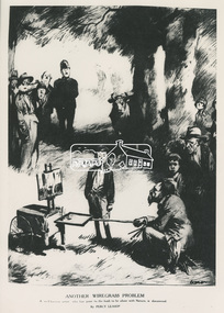
Folder, Percy Leason, 1930s
Folder of information on Percy Leason, Artist, Cartoonist, Historian, Anthropologist, Eltham, 1930s. 1. Photo: ANOTHER WIREGRASS PROBLEM: A well known artist who has gone to the bush to be alone with Nature, is discovered, By Percy Leason 2. Photo: SCENE DURING THE EIGHT HOURSS' DAY SPORTS AT WIREGRASS, By Percy Leason 3. Photo: "FIRE!": "An unfortunate occurrence. When the members of the Wiregrass Fire Brigade assembled at the Fire Station last evening for their weekly practice, they were horrified to discover that the building was on fire." - WIREGRASS WEEKLY CLARION, By Percy Leason 4. Photocopy: "Goliath and the Prodigal David" by Percy Leason 1931 5. Photocopy: "Yes you are improving the place. I'll have to increase your rent." by Percy Leason 1933 6. Photocopy: Cartoon by Percy Leason 1931 7. Photocopy: Cartoon by Percy Leason 8. LEASON, Percy Alexander, Painter and Illustrator; Who's Who in Australia, XIVth Edition 1950 9. LEASON, Percy Alexander, Painter and Illustrator; Who's Who in Australia, date unknown 10. Percy Leason 1889-1959 11. LEASON, Percy Alexander, 1889-1959, Painter and Illustrator 12. Percy Leason: Artist, cartoonist and Historian, by L.J. Blake, B.A., B.Ed., M.A.C.E. (President of the R.H.S.V.); An Address to the Society on Tuesday evening 27 August 1968; The Victorian Historical Magazine, pp 158-180 13. Catalogue: The Percy Leason Collection on view in The la Trobe Library 20 September - 29 October 1971 14. Invitation: Christmas Exhibition, The Wiregrass Gallery, 4 December 1977 15. Newspaper clipping: Artist's retreat, 1980 16. Newspaper clipping: Sharper than snapshots by Giles Auty; Arts, Review, The Weekend Australian, November 13-14, 1999 17. Works by Percy leason held by Castlemaine Art Museum, October 2018alan whitmore estate agents, biography, eltham*, exhibition catalogue, la trobe library, landscape, percy leason, rhsv, shire of eltham pioneers photograph collection, wiregrass gallery -
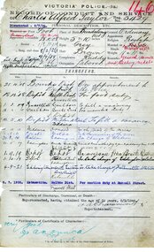 Victoria Police Museum
Record of Conduct and Service (Charles Alfred Taylor)
When the First World War broke out, Australian men from all backgrounds and professions were called to serve their country. Members of the Victorian Police force were some of the first to answer the call with twenty men joining the first convoy of soldiers who left Australian shores in October 1914. Over the course of four long years, one hundred and thirty-eight Victorian Police enlisted from stations across the state. Of these, twenty-seven lost their lives. Whilst the fate of each man was different, a deep commitment to protecting and serving the public was common to all. Victoria Police service: Joined: 28/10/1908; Granted leave without pay: 5/05/1917; Re-joined: 1/10/1919; Retired: 8/02/1946; Highest rank: Inspector WW1 service: Enlisted: 10 May 1917; Highest rank: Corporal; Regiment: 38th Battalion; Fate: Returned to Australia 4 July 1919; Medals: 1914-1915 Star, British War and Victory medalsOfficial documentworld war 1, 1914-1918; victoria police; taylor, charles alfred 5429 -
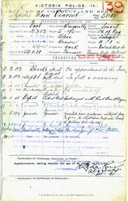 Victoria Police Museum
Record of Conduct and Service (Leslie Moore Vincent)
When the First World War broke out, Australian men from all backgrounds and professions were called to serve their country. Members of the Victorian Police force were some of the first to answer the call with twenty men joining the first convoy of soldiers who left Australian shores in October 1914. Over the course of four long years, one hundred and thirty-eight Victorian Police enlisted from stations across the state. Of these, twenty-seven lost their lives. Whilst the fate of each man was different, a deep commitment to protecting and serving the public was common to all. Victoria Police service: Joined 2/03/1903; Granted leave without pay 1/09/1916; Resumed duties 6/08/1919; Retired 23/01/1941; Highest rank: Sergeant WW1 service: Enlisted 5 May 1916; Highest rank: Lance Sergeant; Regiment: 3rd Australian Divisional Ammunition Column; Fate: Returned to Australia 8 May 1919; Medals: 1914-1915 Star, British War and Victory MedalsOfficial documentworld war 1, 1914-1918; victoria police; vincent, leslie moore 5080 -
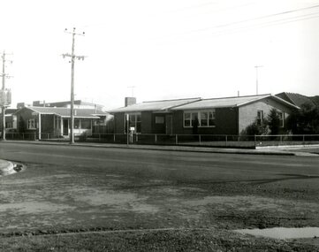 Victoria Police Museum
Police Stations (Altona)
Altona is a suburb of Melbourne, 13 km south-west of Melbourne's CBD and located within the City of Hobsons Bay Altona Police Station opened as a temporary police station in 1919 in the Melbourne District. It was on the corner Sargood and Blyth Streets. It was staffed by one 1st Constable. The original police station was in a small room attached to the front of a 5-roomed weather-board dwelling with an iron roof on land measuring 66' x 165'. There was also a kitchen, vestibule, wash-house, office, one W.C. and a lock-up. In 1929 it became part of the Bourke District. On 31 March 1958 it moved into newly built government premises at 51-53 Blyth Street, on the corner of Bent Street. The building consisted of a cream brick veneer police residence and police station with cell. Staff was increased to a Sergeant in Charge and 3 Constables. A new police station was opened in Altona North on 7th October 1979. The Altona Police Station remained as a sub-station for a few a short time until the building was sold. July 2019 - a new police station is being constructed at 1 Galvin Street, Altona. Galvin Street was names after S/C Michael Arthur Galvin, 3651, who was appointed on 5 Jan 1886 and resigned on 4 Dec 1913. He was Werribee Shire President 1926-1927 and 1940-1941 8 black and white photos of new police station, 1963police stations; altona police station -
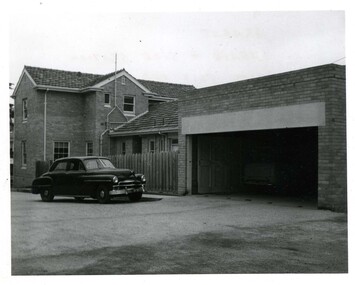 Victoria Police Museum
Police Stations (Ararat)
Ararat is a city in south-west Victoria, Australia, about 198 kilometres west of Melbourne, on the Western Highway on the eastern slopes of the Ararat Hills and Cemetery Creek valley between Victoria's Western District and the Wimmera. It is named after Mount Ararat 10 kilometres south-west of the town. A police station opened in Ararat in 1859, though there was a police presence in the area formerly known as Cathcart, Canton Lead and later Mount Ararat. In 1861 staff consisted of 1 Superintendent, 2 Mounted Constables, 1 Sergeant 2nd class, 1 Senior Constable, 8 Constables. The police reserve was on land bounded by Ligar Street, Barkley Street, Ingor Street and High Street. In 1930 the police station was described as a six-room brick dwelling with a slate roof, situated on one quarter acre of land. There was also a bathroom, wash-house, pantry, office, muster room and quarters for a single constable, stables with three stalls, and a lock-up consisting of two six-person cells. Later residences were located at 3 Ligar Street (brick veneer with a tile roof); 32A High Street (brick veneer with tile roof); and 3 Tobin Street (wood with an iron roof). A new, purpose built police station was opened in October 2010 at 77 Barkly Street. The Ararat Police District was reformed into the Wimmera Police District in 1870. Ararat Police Station became part of "R" (Glenelg) District in January 1948 and "M" (Highlands/Wimmera) District from March 1990. A list of police stationed at Ararat from 1903 - 1930 is available from the Victoria Police Museum8 photos comprising: 7 black & white photos 1 colour photopolice stations; ararat police station -
 RSL Victoria - Anzac House Reference Library and Memorabilia Collection
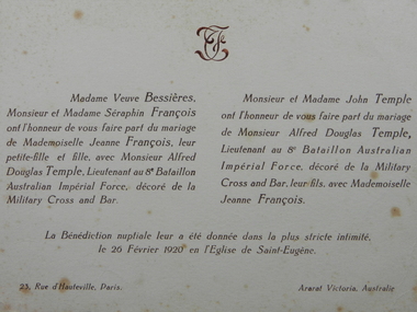
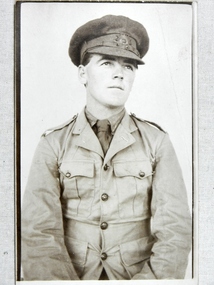
Letters of Alfred Douglas Temple, Alfred Douglas Temple, 1917 - 1920 & 1941
8th Battalion embarked from Melbourne on board Transport A24 Benalla on 19th October 1914. Temple was awarded the Military Cross in mid 1918, and Bar to Military Cross in mid 1919. He returned to Australia in July 1919, and later (1920?) returned to France to marry and live.Collection of Alfred Temple (938 - 8th Battalion, H Company) includes 8th Battalion Christmas card, letter signed by General Birdwood congratulating Lieutenant Temple on being awarded the Military Cross, wedding invitation to the Paris wedding (on 26/2/20) of Lt Temple, and a letter dated 5 December 1941 from Temple - in occupied France - to his mother via a neutral source in USA.military cross, ww1, letters, 8 battalion, alfred douglas temple, general birdwood -
 RSL Victoria - Anzac House Reference Library and Memorabilia Collection
Postcards/Photographs of Raymond Vernon Baldock, Raymond Vernon Baldock, 1914 to 1917
Ray Baldock embarked from Melbourne on board Benalla on 19th October 1914. He fought and was wounded at Gallipoli, and was killed in action in France in September 1917.Approximately ninety WW1 postcards/photographs of Raymond Baldock (520 - 8th Battalion, E Company). Includes one personal letter and one official letter.photographs, ww1, gallipoli, letters, postcards, raymond vernon baldock, 8 battalion -
 RSL Victoria - Anzac House Reference Library and Memorabilia Collection
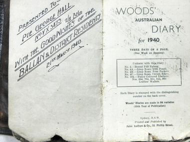
Diary of George William Hall
Hall enlisted in October 1939, and departed Melbourne onboard HMT Dunera in April 1940. Diary runs from April 1940 until April 1942, and includes the evacuations of Greece and Crete. Hall returned to Australia in September 1945.WW 2 diary of George William Hall (VX 3479 2/8 battalion)george william hall, 2/8 battalion, ww2, diaries -
 RSL Victoria - Anzac House Reference Library and Memorabilia Collection
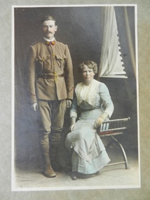
Photographs and Letters of Frederick George & Mary Jane BOXALL
George Frederick Boxall (1051 8th Battalion H Company), a miner from Bendigo, embarked from Melbourne on board Transport A24 Benalla on 19 October 1914. He returned to Australia on 8 May 1916, having suffered "shell shock" from a bomb blast on Gallipoli in September 1915.Hustlers Mine photograph inscribed on rear : "at the mouth of the shaft after the accident at Great Extended Hustlers"ww1, george frederick boxall, mary jane boxall, mary jane johnson, william henry johnson, 8th battalion, linton percy clarence rudd, allan tathorn moffat, robert carter, photographs, letters, great extended hustlers mine, shell shock -
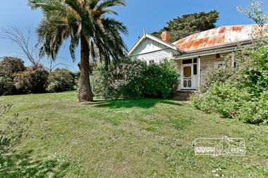 Eltham District Historical Society Inc
Photograph, Gayle Blackwood, Belle Vue, 17-21 Livingstone Road, Eltham, October 2011
8 born digital images (Morrison Kleeman)gayle blackwood collection, houses, eltham, belle vue, livingstone road -
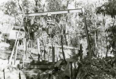
 Ringwood and District Historical Society
Photographs, 1979-80 MMBW pipe line project at Hubbard Reserve, North Ringwood � Grating over hole in Chalkley's 41 Burlock Avenue
Part of a 43-photo record of the MMBW�s engineering feat in drilling a 12 inch pipe line up to 40 feet deep through rock hardened by volcanic action associated with geological fault that occurs along the line. The work took place from October 1979 to May 1980 on the southern boundary of Hubbard Reserve, North Ringwood. The collection was presented to the Ringwood Historical Research Group by J Clarke on 9th June 1980.E560 N25 Jan 1980 A43 Grating over hole 37 feet deep in Chalkley's 41 Burlock Avenue (lot 8) -
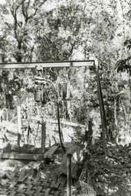
 Ringwood and District Historical Society
Photographs, 1979-80 MMBW pipe line project at Hubbard Reserve, North Ringwood � View along line work in Hibberd's and Chalkley's
Part of a 43-photo record of the MMBW�s engineering feat in drilling a 12 inch pipe line up to 40 feet deep through rock hardened by volcanic action associated with geological fault that occurs along the line. The work took place from October 1979 to May 1980 on the southern boundary of Hubbard Reserve, North Ringwood. The collection was presented to the Ringwood Historical Research Group by J Clarke on 9th June 1980.E560 N27 Jan 1980 A43 View along line work in Hibberd's and Chalkley's (lot 9 and 8) -
 Ringwood and District Historical Society
Photographs, 1979-80 MMBW pipe line project at Hubbard Reserve, North Ringwood � Air winch over the hole in the corner of Chalkley's
Part of a 43-photo record of the MMBW�s engineering feat in drilling a 12 inch pipe line up to 40 feet deep through rock hardened by volcanic action associated with geological fault that occurs along the line. The work took place from October 1979 to May 1980 on the southern boundary of Hubbard Reserve, North Ringwood. The collection was presented to the Ringwood Historical Research Group by J Clarke on 9th June 1980.E561 N1 Feb 1980 A43 Air winch over the hole in the corner of Chalkley's (lot 8) -
 Ringwood and District Historical Society
Photographs, 1979-80 MMBW pipe line project at Hubbard Reserve, North Ringwood � First hole in Lot 8
Part of a 43-photo record of the MMBW�s engineering feat in drilling a 12 inch pipe line up to 40 feet deep through rock hardened by volcanic action associated with geological fault that occurs along the line. The work took place from October 1979 to May 1980 on the southern boundary of Hubbard Reserve, North Ringwood. The collection was presented to the Ringwood Historical Research Group by J Clarke on 9th June 1980.E561 N2 Feb 1980 A43 Final hole in lot 8 (no. 41) at the corner of Chalkly's -
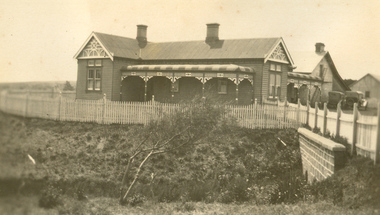 Cheese World Museum
Photograph, Tooram Park homestead c1915, early 20th century
The Percy Uebergang family lived at Tooram Park, Allansford from 1912 until 1992. Percy and Myrtle Uebergang's children were twins, Ray and Joyce born in 1926 who lived at Tooram Park until their deaths, Ray in 1986 and Joyce in 1992. Neither Ray nor Joyce married and following the death of her brother Joyce set up the Ray and Joyce Uebergang Foundation which supports the local community. This photograph is part of the collection of items given into the care of the Cheese World Museum. The Uebergang family purchased Tooram Park in 1912. It was part of the original Tooram run which was taken up in 1839/40 by John McMahon Allan. Allan held the property until 1860 after which it passed through several owners including John Orlebar, Thomas McLeod Palmer, Owen family. Tooram was famous for the cheese from its large dairy herd. The herd was hand-milked. Palmer employed Indian labour to undertake this task. In 1883 Palmer was charged with the manslaughter of an Indian worker but was acquitted. This case was extensively reported in the Warrnambool Standard. The Standard also featured a number of articles about Tooram [22 June 1882, 17 March 1883 to 15 May 1993, 30 October 1886, 22 October 1897, 11 May 1926, 8 June 1931]. The property remained in the Uebergang family until after Joyce's death in 1992. Tooram is significant as it was one of the earliest runs taken up in the Warrnambool area. It was divided up following its sale in 1897. Tooram cheese was renowned. This photograph is significant as it shows Tooram Park homestead in its earlier days with the prolific timber decoration which was later removed.Black & white photograph on a cardboard mount showing Tooram Park homestead. The house has a white picket fence. A drain is in the foreground and is serviced by a stone culvert is in the right foreground. Two cars are parked in front of the house. The house walls are painted a dark colour. The verandah roof is striped dark and white. The timber decoration on the verandah, barge board and gable is white.allansford, tooram, tooram park, uebergang, john orlebar, john mcmahon allan, thomas mcleod palmer, owen family, indian labour, court cases, dairying, dairying, warrnambool standard -
 Glen Eira Historical Society
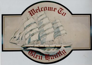
Article - GLEN HUNTLY (HISTORY OF)
This file contains 10 items about the history of Glen Huntly: 1/6 photocopied pages from ‘The History of St Kilda’ which relates to the place name Glen Huntly, and the Quarantine graves, date unknown. 2/2 photocopied pages from the ‘Sun Pictorial’ dated 13/4/1928 and 12/4/1928; relating to the state of the graves at Point Ormond and their re-internment to St Kilda Cemetery. 3/1 pen and ink sketch of graves at Point Ormond from the State Library Victoria. 4/3 pages taken from a website on the re-internment of graves and some social history as to the reason that the new emigrants were coming to Australia. The Article also has 7 photographs. 5/2 newspaper articles on the ‘Glen Huntly’ descendants forthcoming reunion being held on 21&22/4/1990. 6/1 article reprinted from newsletter no. 22 October 1983 on the barque ‘Glen Huntly’. Also details of passengers who died and the burial of 3 at Point Ormond. 7/1 handwritten document (unattributed) taken from ‘Migrant ships for South Australia 1836-1850’ by Ronald Parsons. 8/1 pamphlet commemorating the 150th anniversary of the ‘Glen Huntly’ arriving in Melbourne. It gives information about the ship, passengers, memorial in St Kilda Cemetery and upcoming descendants’ reunion. 9/1 program of commemoration events 21&22/4/1990. 10/1 piece of art work for a ‘Welcome to Glen Huntly’ sign, featuring a ship. Undated, unattributed and source unknown.‘glen huntly’, buchanan captain, fever ship, emigrants, cummins ann, st kilda cemetery, bowman mrs, caulfield, craig john, cameron miss, mcgonagle mrs, elsternwick, armstrong george, mathers james, the glen huntly pioneers memorial, jones alfred ramsey, st david’s uniting church (grange road), glen huntly, glen huntly road, lake street, glen huntly state school, glen huntly presbyterian church, south caulfield, mernda avenue, garden avenue, grange road, jenkin (boss) william, wattle avenue, chinese joss-house, smith a.w, glen huntly post office, foundation stones, king f.l, methodist church, trinity congregational church, greek orthodox church, salvation army temple, wanalta road, st anthony’s roman catholic church, st agnes’ anglican church, booran road, st david’s uniting church, el nido grove, manses, royal avenue, munster avenue, james street, rothschild street, neerim road, organs, peace memorial organ, railways, marara road, curraweena road, booran road, bambra road, rosstown railway, murray-ross william, leila road, murray-ross leila, ‘the grange’, north road, wild cherry road, ‘rosstown’, picture theatres, manchester grove, aerodrome, lord reserve, neville street, lyons street, morgan street, rosedale avenue, rifle clubs, glen huntly infant welfare centre, watson grove, rowlands drapery, drapers, bones plant nursery, nurseries, elsternwick railway station, railway stations, kooyong road, glen eira road, truganini road, rosstown sugar works, ross murray, street names, typhoid, diseases, death and dying -
 Glen Eira Historical Society
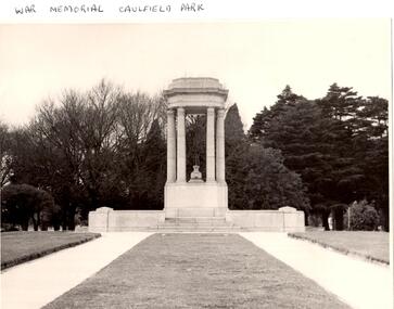
Article - Memorials in Glen Eira
This file contains 11 items relating to War Memorials in Glen Eira: 1/Black and white photograph, undated, source unknown, of Caulfield Park War Memorial 2/Copy of photograph of Caulfield Park War Memorial, undated, source unknown 3/Colour photograph of Caulfield Park War Memorial, dated June 1982, source unknown, and slide of same 4/Print of webpage of Friends of Caulfield Park, dated 02/08/2013 with colour image of and information about the war memorial there 5/Two black and white photographs, undated and source unknown, of war memorial at Koornang Park 6/Four colour photographs and one black and white copy of photograph of war memorial and its inscription at Koornang Park. Date and source unknown 7/Article dated 30/04/2013 from GLENEIRA LEADER about funding for plaque for Lone Pine at Caulfield Park 8/Article dated 23/04/2013 from THE AGE about state funding for repair of war memorials including one at McKinnon 9/Article dated June 2013 from GLEN EIRA NEWS about state funding for repair of five WWI memorials in Glen Eira. Includes two photographs. 10/Article from GLEN EIRA NEWS dated April 2012 about restoration of Caulfield Park War Memorial. Includes colour photography 11/A booklet titled 'The Burra Charter and its Application: Essay 3: War Memorial, Caulfield Park', written in October 2000 by Eleanor Bishop. The booklet contains a conservation analysis, statement of cultural significance, statement of conservation policy, and conservation management plan for the Caulfield Park War Memorial. This includes a brief history and description of the Caulfield Park War Memorial, and 7 colour photographs of the memorial dated September 2000, 2 undated black-and-white photographs, and a copy of the original drawing of the memorial which won its design contest in 1930.monuments and memorials, war memorials, plaques, world war 1914-1918, caulfield park, friends of caulfield park, ritchie mr, world war 1939-1945, koornang park, city of caulfield, glen eira, glen eira council, mckinnon war memorial, hopetoun gardens, hyams jamie, mckinnon, lobo oscar, esakoff margaret, hyams jamie, delahunty ms, caulfield rsl, kiernan noel, bishop eleanor, caulfield park war memorial, foot henry b., parks and reserves, paddy's swamp, caulfield, royal victorian institute of architects, caulfield municipal council, architectural competitions, schefferle n. mr, architectural features, conservation management plan -
 Federation University Historical Collection
Photograph - Photograph Album, Photographs of Ballarat Buildings, 1967, 1967
When these photos were taken Geoffrey Biddington was highly involved with the Ballarat Branch of the National Trust. At one time Her Majesty's Theatre was known as the Memorial Theatre. Lenaghan of Tourello "Master Dan Lenaghan, eldest son of Mr. and Mrs. R. Lenaghan, of Tourello, has been successful in obtaining a Government scholarship, tenable for four years at St. Patrick's College, Ballarat.(Melbourne Advocate, 02 March 1939) Two Black folders of Ballarat photographs as follows: .1) Interior of Ballarat Railway Station .2) Interior of Ballarat Railway Station .3) Craig's Hotel .4) Craig's Hotel .5) Craig's Hotel .6) Craig's Hotel .7) Ballarat Fine Art Gallery later Art Gallery of Ballarat .8) Cuthberts, corner Lydiard and Mair Streets .9) Golden City Hotel (GCs) .10) Golden City Hotel (GCs) .11) Reid's Coffee Palace .12) Alexandria Tea Rooms, neighbouring Old Colonists' Club, Ballarat, Lydiard Street North .13) ? .14 Caste iron drink fountain, corner of Strurt and Drummond Streets, October 1967 .15) Lal Lal Blast Furnace .16) Ballarat Botanical Garden Gates .17) Ballaarat Old Cemetery Gates .18) Novar gate .19) Ballaarat Old Cemetery Gates .20) ? .21) Webster Street .22) Doveton Street South .23) ? .24) ? .25) .26) .27) Iron hitching Rail .28) Iron hitching Rail .30) Postal Box, Corner or Armstrong Street South and Eyre Street, October 1967 .31) Iron Drinking Fountain in the Ballarat Botanical Gardens .32) Iron Drinking Fountain in the Ballarat Botanical Gardens .33) Killarney, Warrenheip .34) Killarney, Warrenheip .35) Killarney, Warrenheip .36) Killarney, Warrenheip .37) Bailey's Mansion, Drummond Street .38) Bailey's Mansion, Drummond Street .39) Beaufort House .40) Beaufort House .41) ? .42) ? .43) ? .44) ? .45) ? .46) ? .47) ? .48) Lenaghan's Tourello, February 1968 .49) Lenaghan's Tourello, February 1968 .50) ? .51) ? .52) ? .53) ? .54) ? .55) ? .56) ? .57) ? .58) ? .59) ? .70) Her Majesty's Theatre, Lydiard Street .71) Her Majesty's Theatre, Lydiard Street .72) Dana Street Primary School, September 1967 .73) Ballarat School of Mines Administration Building, September 1967 .74) Eureka Street Primary School ? .75) Selkirk Brick Chimney? .76) Grigsby's Foundry, Mair Street, September 1967 .77) Pratt's Warehouse, Camp Street .78) Premises of R. And R.A. Williams, Mair Street, September 1967 .79) City Oval Grandstand, with fire training tower in the background, .80) City Oval Grandstand .81) City Oval Grandstand .82) Smythesdale Post Office, October 1967 .83) Court House Hotel. Smythesdale, October 1967 .84) Smythesdale, October 1967ballarat, buildings, bluestone, iron, architecture, biddington, geoff biddington, railway, old colonists, lal lal blast furnace, beaufort house, her majesty's theatre, craig's hotel, botanical gardens, bailey, cuthbert, lenaghan, tourello, smythesdale post office, court house hotel, smythesdale, smythesdale, alexandria tea rooms, cast iron, eureka street primary school, dana street primary school, ballarat school of mines administration building, grigsby brass founder, foundry, pratt's warehouse, selkirk bricks, grandstand, court house hotel -
 Federation University Historical Collection
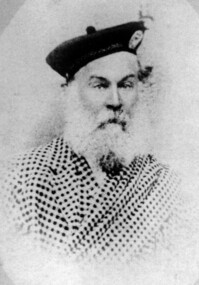
Photograph - Photographs, Hugh Gray
Hugh Gray was the son of Charles Gray and Robina Tait. Hugh was born on 7 January 1810 at Alloa Clackmananshire, Scotland, and married Elizabeth Paterson on 8 July 1831 at Glascow, Scotland. Hugh, Elizabeth and their eight children boarded the 'Borneuf' and set sail for Australia from Glasgow on 20 May 1852. In October 1853 Hugh Gray set up a blacksmiths forge on Main Road Ballarat. He was a member of the Ballarat Reform League. In July 1857 he donated 5 pounds to the Humffray Testimonial on behalf of the Blacksmith Association. In 1858 and 1877 he was the President of the Caledonian Society, and a committee member at other times. Gray was also one of the first promoters of the Mechanics' Institute. On 14 March 1869 Hugh Gray started the Philosophical Association of Ballarat. Hugh Gray died on 02 June 1880. His obituary notes '... all the patrons of the long since dead Caledonian sports will remember his shepherd's plaid costume and his untiring energy at the annual gathering whether as president or committee member to even a private member of the society. his end was peaceful and he will be buried as he wished in good old Scottish fashion ...'Photograph of Hugh Gray.ballarat, blacksmith, hugh gray, hugh grey, scotland, scottish, caledonian, kilt, borneuf