Showing 2134 items matching "kiewa"
-
 Kiewa Valley Historical Society
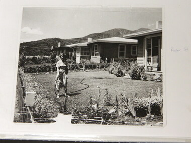
Photographs – Kiewa Cres Mt Beauty. Circa 1993. Set of 12 colour photographs
Established in 1946, during the construction of the Kiewa Hydro Electric Scheme, the township of Mt Beauty was developed by the State Electricity Commission of Victoria to provide additional accommodation for the thousands of workers during the construction of the country’s second largest hydro-electricity scheme. Although these towns were built as temporary accommodation for the workers and their families, many stayed after the scheme finished. Combined with the influx of European migrants, with their rich cultural backgrounds, all played a major part in shaping the future character of the Mount Beauty, the Kiewa Valley and Falls Creek. The Bright Council, now the Alpine Shire took over the control of the township in 1960. This relatively young town of Mount Beauty, along with the surrounding townships of Falls Creek, Bogong, Tawonga South and Tawonga, are all part of a prospering tourist area with excellent services, accommodation, food and a wide range of recreational activities available for all ages. According to Shire records, the population of Mt Beauty has grown from 1,500 in 1981 to 1,800 in 2016 with a projected increase to 2,000 in 2013The photographs taken around 1993 show a prosperous commercial centre catering for both locals and the needs of visitors. It provides a pictorial history of the changes which have occurred in the retail/commercial district of Mt Beauty over the years. It also demonstrates the attention paid by Alpine Shire towards providing accessible recreational green space around the town centre.Set of 12 colour photographs of Kiewa Cres Mt Beauty. Circa 1993 showing retail services and streetscape of the time. No markingskiewa cres mt beauty, mt beauty -
 Kiewa Valley Historical Society
Photographs – Kiewa Cres Mt Beauty. Circa 1993. Set of 12 colour photographs, circa 1993
Established in 1946, during the construction of the Kiewa Hydro Electric Scheme, the township of Mt Beauty was developed by the State Electricity Commission of Victoria to provide additional accommodation for the thousands of workers during the construction of the country’s second largest hydro-electricity scheme. Although these towns were built as temporary accommodation for the workers and their families, many stayed after the scheme finished. Combined with the influx of European migrants, with their rich cultural backgrounds, all played a major part in shaping the future character of the Mount Beauty, the Kiewa Valley and Falls Creek. The Bright Council, now the Alpine Shire took over the control of the township in 1960. This relatively young town of Mount Beauty, along with the surrounding townships of Falls Creek, Bogong, Tawonga South and Tawonga, are all part of a prospering tourist area with excellent services, accommodation, food and a wide range of recreational activities available for all ages. According to Shire records, the population of Mt Beauty has grown from 1,500 in 1981 to 1,800 in 2016 with a projected increase to 2,000 in 2013The photographs taken around 1993 show a prosperous commercial centre catering for both locals and the needs of visitors. It provides a pictorial history of the changes which have occurred in the retail/commercial district of Mt Beauty over the years. It also demonstrates the attention paid by Alpine Shire towards providing accessible recreational green space around the town centre.Set of 12 colour photographs Kiewa Cres Mt Beauty. Circa 1993 showing retail services and streetscape of the time. No markingskiewa crescent mt beauty; shopping centre; -
 Kiewa Valley Historical Society
Folder - Early Photos of Mt Beauty
Mt Beauty township was built during the 1950's to house the employees of the State Electricity Commission working on the Kiewa Hydro Electric Scheme. After the completion of the Kiewa Hydro Electric Scheme many houses were sold and the public buildings handed over to the Alpine Shire. Mt Beauty has always been a tourist destination especially with its proximity to the ski fields at Falls Creek.This folder contains many early photos of Mt Beauty showing the construction town during its development during the Kiewa Hydro Electric Scheme and its early days of tourism. A3 size black plastic folder with clear plastic sleeves holding early black & white photos of Mt Beauty township. Also included are: 1. 3 foolscap pages -Nov., 1953 Kiewa Hydro-Electric Scheme Progress. 2. SECV Drawing Plan (No. K6242) of Mt Beauty House - 3 angles and floor plan, English Pre-cut Type 3B.ILA with note that all houses with prefix 3B are similar. 3. Orange, black and white pamphlet "Welcome to Kiewa" 4. Tourist postcard 'fold-up' of 11 postcards "Mt Beauty and the Kiewa Scheme, Victoria 5. Drawing Plan of 'Mt Beauty Housing. Use of Prefabricated Cubicles for Houses. Type C.1 6. Drawing Plan of 'Kiewa Scheme Mt Beauty Housing Type "G". 7. 5 pages on "Twelve Tips on Caring for Old Buildings 8. Booklet advertising Mt Beauty housing for sale including activities available in the area. (1960's) 9. List of Photos from SECV held by KVHS Some photos have handwritten labels mt beauty. secv. kiewa hydro electric scheme.tourism. housing. construction town. falls creek. -
 Kiewa Valley Historical Society
Postcard - Rocky Valley - Circa 1950, 1950
This postcard was produced in the 1950's for the tourist trade in the Kiewa Valley and Alpine region. It encompasses the period when the State of Victoria was pressured by the ever increasing demand by industry and its population for electricity supplies. Hydro electricity was seen as an untapped natural resource to quench this demand. The Victorian Alps and the rivers flowing into its valleys was ideal for the construction of the Kiewa Hydro Electricity Scheme. The late 1940's saw the development of this scheme and the changing of sections of alpine landscape is covered by this and other postcards/pictures (tourists, construction workers, and established rural populations). This period in time was before the established wildlife and forest/nature groups became political activist who changed legislative acts to protect the environment.This rural region (Kiewa Valley/alpine plains) was at most only significant to a smaller group of winter sports, summer hikers/horse riders and rural farmers/graziers. The numbers of tourists and the increase in the local resident population was boosted by the construction of the Hydro Electricity Scheme. This influx to the regional population resulted in a corresponding diversity in services and brought about an environment that responded to a growing level of tourists and thereby permitting this industry to grow more rapidly than it would have naturally. This postcard details an attraction to the "cleaner" method of providing electricity. This postcard was purchased in 1950 by a surveyor at Landford's Gap.This black and white photograph is from a Valentine's V2 Argus postcard. It is on a 200g/m paper density one side gloss. See also KVHS 0480 (A) to (L) for similar postcards. "ROCKY VALLEY FROM BOGONG HIGH PLAINS KIEWA HYDRO-ELECTRIC PROJECT" "V1"kiewa valley tourism, victorian alps, alternate energy supplies, alpine population growth, rocky valley, secv -
 Kiewa Valley Historical Society
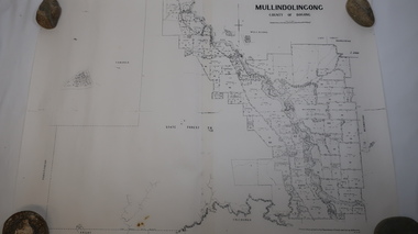
Map - Mullindolingong
Land owners of land in the Kiewa Valley in 1928The Kiewa Valley was farming country with families settling in the area prior to 1928 Two sheets the same: (one old with paper joined together and the other is a copy without any joins. 21 6 1928 dated Map of Mullindolingong / County of Bogong showing land owners along the Kiewa River and beyond.Produced by the Department of Lands and Survey, Melbournemullindolingong, kiewa valley, land owners, families of the kiewa valley -
 Kiewa Valley Historical Society
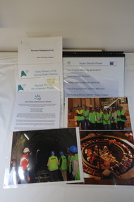
AGL - Bogong Information Centre
AGL took over the operation of the Kiewa Hydro Electric Scheme and constructed the 'Bogong Power Development Project. This involved the construction of a new underground Hydro Electric Power Station on AGL Hydro's Junction Dam regulating pondage near Bogong village in Vctoria's High country. Construction commenced in 2007 and was completed by the end of 2009The Bogong Power Development Project was important to Victoria as hydro power was environmentally friendly. It was important to convey this to the population by way of educating them on the understanding of how it worked and its benefits to providing power to Victoria and beyond.Collection of photos, folders and papers used at the Bogong Information Centre to inform the public on the operation of the Kiewa Hydro Electric Scheme. Dated 2007 - 2009bogong power development project, agl hydro at bogong -
 Kiewa Valley Historical Society
Map - Topographical, Ski Club of Victoria Bogong High Plains and Adjacent Peaks, Early 1930's
This map has been in the Ryder family for approx. 70 years. Probably used when bush walking and skiing in the early days on the Bogong High Plains. The Ryder family are farmers in the Kiewa Valley and were involved in taking their cattle up to the Bogong High Plains where they had a lease. The State Electricity Commission of Victoria constructed the Kiewa Hydro Electric Scheme opening up the area during the 1940's and 1950's. This type of map is an early one, used by people in the Kiewa Valley and possibly by surveyors prior to construction.The map is an early topographic map used by farmers living in the Kiewa Valley. It is historically significant as these people were involved in taking cattle up to the High Plains during summer and may have been used for bush walking and skiing.This is a sepia coloured paper map which was originally printed copyright registered. It was revised in 20/6.33/4.4.37/8.4.40/24.8.43/19/6/54. It shows roads / tracks / snow poles / snow pole numbers (27) / Snow pole spacing (3 chains. 66 yards) approximately 27 poles to the mile / height above sea level in feet - 5280. Water courses not definitely located etc.Rocky Valley Dam (Kiewa Hydro Electric Scheme) has been drawn on the map by hand with a biro. There is a wooden rod at the top of the map.topographic map; kiewa valley; ryder family; high plains of victoria -
 Kiewa Valley Historical Society
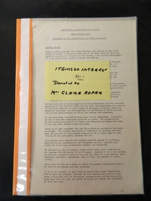
Folder - Clare Roper No. 4, Early Historical Records
Clare Roper was a resident of the Kiewa Valley and belonged to the Kiewa Valley Historical Society.Clare Roper collected and collated items of historical interest for the Kiewa Valley Historical Society.Dark blue plastic with clear front cover with 11 plastic sleeves / pages. Includes: "The Discovery of the Bogong High Plains" dated 1962 from RHSV.; 'Tawonga History' dated 1964; Kiewa Valley C.W.A letter re Tangambalanga; History of the Bogong hotel at Tawonga; Memories of Wilma Roper, 1987. Yackandandah History. Ovens Crossing. Mullagong. Tawonga Hometead. clare roper; scrap book; -
 Kiewa Valley Historical Society
Kiewa Hydro Electric Scheme - Extract from 'Water Power' June 1962 & 'Kiewa Keynotes' from SEC Magazine
The SECV produced a magazine from the 1930s describing each of their locations where their employees were working. Bogong and Mt Beauty were the towns where the workers on the Kiewa Hydro Electric Scheme lived as well as in camps on the Bogong High Plains. The magazines kept everyone up to date on the SEC work and social activities at all locations creating a Work Community for all employees as they moved from one job to another.Photocopied pages 213 to 221 from the book 'Water Power' June 1962 and photocopied pages from SEC Magazine - Kiewa Keynotes circa late 1940s-early 1950skiewa hydro electric scheme, secv magazine, kiewa keynotes, water power -
 Kiewa Valley Historical Society
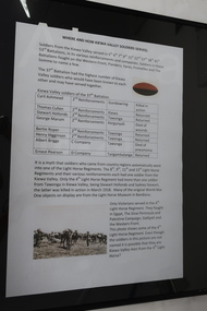
Posters - "Tawonga Remembers" x 8
The town of Tawonga is in the Kiewa Valley surrounded by farmland. it is adjacent to Mt Beauty (built from 1946), an SECV town built for the workers on the Kiewa Hydro Electric Scheme which was being constructed from 1911 to 1961. Tawonga consisted of essential amenities including a store, school, butter factory, sporting facilities, post office, hall and hotel. Activities involved sport, social get togethers eg. dances, fundraising, CWA etc. The posters are a collection of historical photos, documentations and information regarding the history of the town of Tawonga, which is the centre of a farming community in the Kiewa Valley.Posters framed with thin black plastic strip, covered by glass. Each one has a title re "Tawonga Remembers" and includes print and photos in black and white. White background. 1. Where and How Kiewa Valley Soldiers Served; 2. Tawonga and Dederang Servicemen; 3. Kergunyah and Gundowring Servicemen and Women; 4. Kiewa and Tangambalanga Servicemen.5. Sacrifice and Honour; 6. The End of the Great War; 7. World War 1914-18; 8. Soldiers in Uniform (Black background and glass cracked) tawonga, photos of early tawonga, kiewa valley, tawonga remembers, ww1 -
 Kiewa Valley Historical Society
Folder - History of Mt Beauty Township, 1980's
'The Kiewa Story' by Graham Napier requested submissions by residents of Mt Beauty for inclusion in his book. The submissions give a lot of detail and cover many subjects.An in-depth history as remembered by people who lived and worked on the Kiewa Hydro Electric Scheme from the 1940's onwards. Many lived locally in the construction towns of Mt Beauty and Bogong.A collection of papers in a white folder with submissions by locals as requested for the book "The Kiewa Story" by Graham Napier, Geoff Easdown in 1986. There is an Index and also included a note that' submissions tell the story of the community involvement in Mt Beauty's development.kiewa story; graham napier; mt beauty; kiewa hydro electric scheme; state electricity commission of victoria; communities -
 Kiewa Valley Historical Society
Photograph of Lake Guy and Bogong Village, Lake Guy and Bogong Village, Approx. 1945
In 1940 Field Headquarters for the Kiewa Scheme were established at Bogong with office, workshop facilities and accommodation for workmen, staff and some families constructed. (There had been a 'tent camp' on this site in 1939 but was destroyed by bushfires) Construction of accommodation continued until 1947. A total of 40 houses plus a hostel for single staff, post office, police station, medical centre and primary school all with water and sewerage and electricity supply. The staff hostel was known as Kiewa House and is now occupied by the Education Department. Lake Guy was named after Mr. L.T. Guy who was the Resident Engineer in charge of construction work and associated activities on the Kiewa area. He held this position from 1939 to November 1946 when he was transferred to Head Office.This photograph is an excellent historical record of Bogong Village in about 1945. It shows the layout of the town in the fairly steep terrain, the workmen's camp between the houses and the lake foreshore, the Commissioner's Lodge on the hill behind the Village, the walkway through the dam wall can be seen to the left of the spillway, the dam is on spill and note damage to the large trees is still evident from the 1939 bush fires. The Commissioner's Lodge was lost in the 2003 fires and the camp buildings were in service until 1962, when they were removed and the site converted into a public picnic area with lawns and gardens.A Black and white photograph"Lake Guy and Bogong" hand written on back of photograph.kiewa, accommodation, lake, dam, bogong -
 Kiewa Valley Historical Society
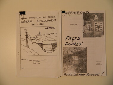
Papers - The Kiewa Hydro Electric Scheme x2, 1973 and 1993
1. Chronological account of the Kiewa Hydro Electric Scheme from 1911 to 1961 2.Victorian Hydro with technical facts and figures, with Aboriginal History of the region, Settlement of the Kiewa Valley, Origin of Names Both accounts are a history of the Kiewa Hydro Electric Scheme constructed by the State Electricity Commission of Victoria. The first is and abbreviated history of the scheme published by the SEC, the second is similar with 'facts & figures' accessed by Bill Sutton, (Mt Beauty resident and SEC worker) whose father worked on the scheme, and who enjoyed speaking to visitors and groups about the history of the area including some of the light hearted aspects of the history.The Kiewa Hydro Electric Scheme General Development 1911 - 1961 by SECV, July 1973. Consists of 22 A4 pages held within a folded A3 sheet Victorian Hydro compiled by W. Sutton Nov. 1993. Office Copy / Facts & Figures. Consists of 44 A4 pages held by a metal clip.kiewa hydro electric scheme, state electricity commission of victoria, bill sutton -
 Kiewa Valley Historical Society
Photos - Kiewa Hydro Electric Scheme, Official S.E.C.V. photos
Kiewa Hydro Electric Scheme -
 Kiewa Valley Historical Society
Photos - Kiewa Hydro Electric Scheme - Not Identified, Official S.E.C.V. photos
Kiewa Hydro Electric Scheme -
 Kiewa Valley Historical Society
Photos - Kiewa Hydro Electric Scheme - Not Identified, Official S.E.C.V. photos
Kiewa Hydro Electric Scheme -
 Kiewa Valley Historical Society
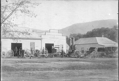
Photo - Blacksmith and Coach Builder business in Kiewa
This business in Kiewa served farmers and residents in the Kiewa Valley. Originally opened in the 1880s before J. E. Ballard took over. Blacksmith and coach builder trades were taken over by motor cars and tractors.The creation and decline of a blacksmith and coach builder business in the Kiewa Valley.Sepia photo of wheels, buggies and people in front of premises with a house next door. On the business is - J.E. Ballard / General Blacksmith / and / Coach Builder / Repairs Painting. The photo is glued onto thick dark grey cardboard creating a border. This photo is published on pages 7, 44, and 52 of 'A History of the Kiewa Valley' by Esther Temple and David Lloyd blacksmith, coachbuilder, j.e. ballard -
 Kiewa Valley Historical Society
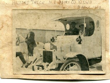
Photographs x 2- Halford truck, 1. 11/7/1972 2. Unknown
The Hallford truck was made by J & E Hall, of Dartford, England, whose business commenced in 1785. In 1926 the Fisher family of Mongan's Bridge took delivery of the 1923 Hallford truck which was used on the farm to transport cream to the Kiewa Butter Factory in Tangambalanga. In 1967, the truck was sold to Mr Greg Bedstead and other members of the Kiewa Valley Historical Society for the KVHS who reimbursed them at a later date. The truck was housed at the Butter Factory for many years and was paraded on special occasions.This truck was used to transport cream to the Kiewa Butter Factory from the Fisher family's dairy farm at Mongan's Bridge. At other times a tyre was removed and a belt attached to run a chaff cutter. This truck has historical significance as it is presentative of vehicles which were used by farmers to transport cream to the butter factories by a local family. Furthermore, it has social significance as KVHS members combined their finances to purchase this truck so it would be part of our collection. It is well provenanced and has an excellent interpretive capacity.2 black and white photographs mounted on buff card 1. Photograph of Halford truck with man on white horse riding alongside. Presumably in a parade. Dated 11th July, 1972 when truck was no longer in service. 2. Photograph of Halford truck followed by a horse and buggy. Date unknown1. Handwritten in black ink above photo 'Halford truck N.E. Dairy Co. Kiewa. 11 July, 1972' 2. No markingshallford truck, fisher family, kiewa valley farmers, dairy truck -
 Kiewa Valley Historical Society
Folder - Clare Roper No. 1, Items of Interest
Clare Roper was a resident of the Kiewa Valley and belonged to the Kiewa Valley Historical Society.Clare Roper collected and collated items of historical interest for the Kiewa Valley Historical Society. Orange plastic with clear front cover and 10 clear sleeves / pages. Includes - SECV brochure "Visit Victoria's beautiful Upper Kiewa Valley" Newspaper Article 30 July 1986 - "Ory Frehauf 'Father' - 61 year old Russian has lived at Falls Creek for 32 years" and an article - "Snow shoeing at Falls Creek" Newspaper Article 4 Nov. 1989 - Audrey Edmondson at Mt Beauty Pondage & Lions Clubclare roper; scrap book; -
 Kiewa Valley Historical Society
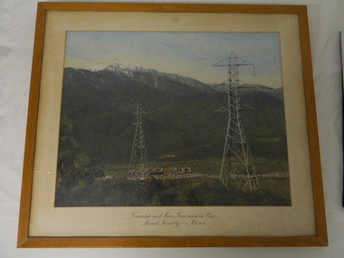
Framed photo - Mt Beauty Township & Main Transmission Line, 1954
This is a photo of Mount Beauty taken from a high vantage point near the hair-pin bend on the Tawonga Gap Road (half way up) in 1954. Mount Beauty was built by the State Electricity Commission of Victoria during the construction of the Kiewa Hydro Electric Scheme.This photo belonged to Mr & Mrs Gordon White SECV employee and long time residents of Mt Beauty.This is a framed coloured photo of the Mount Beauty Township and main Transmission Line from Mt Beauty to Kiewa. The photo has two transmission lines in the foreground with the Mt Beauty township in the background, but at the foot of Mount Bogong.Approx 1954 / Conroy-Moffatt Pty Ltd / Picture Framer / ..McKillop Street / Tel Mu .. 78 ....mt beauty; transmission line; tawonga gap road; kiewa hydro electric scheme -
 Kiewa Valley Historical Society
Ron White's Collection - 1920 - 2019
Ron White was born in 1920. He received a Diploma of Mechanical Engineering at Footscray Technical School in 1946. He started work as a laboratory assistant and after several promotions was appointed Senior Operator in 1948. In 1949, he was Engineer, Grade 1 (Hydro Areas). After further promotions he became Assistant Area Engineer, Rubicon at new Eildon Power Station and Area Engineer, Kiewa in commissioning Mt Beauty Terminal Station and West Kiewa Power Station.. By 1956, he was the Area Operations Engineer at Kiewa and four years later the Kiewa Electrical Superintendent (Operations and Maintenance) . In 1961, he was officially recognised as deputy for the General Superintendent, Kiewa. In 1966 he was appointed General Superintendent Kiewa and Kiewa became 'a branch of the Transmission Department'. In 1974, the Rubicon / Eildon Area was also under Ron's control. His title was "Principal Hydro Engineer, Hydro Division, Transmission Operations Department. He held this position until his retirement in 1985.Ron White was an important identity in his role as Principal Hydro Engineer from 1966 to 1985 after the completion of the Kiewa Hydro Electric Scheme. His long period of service involved him in the construction, operation and maintenance of the SECV's Hydro Electric Schemes and administration of related catchment areas. He had a close association with the local communities and care for the welfare of employees. He lived in Mt Beauty and was well respected in the community and beyond. He passed away on 30 September 2019, aged 99 years.A) History of Ron White's Working Life: including papers relating to "Promotion & Staff Appointment" B) Ron White's Retirement - 11th Jan. 1985: papers, cards, letters, photos, disc/plaque C) Ron White's Certificates: Diploma of Mechanical Engineering; First Aid; D) Ron White's Correspondence - miscellaneous E) Ron White's History of the 'Kiewa Scheme' from 1936- 1966. Written 1986 F) Ron White's Photo album Includes photos of him and the 2003 bushfires G) Miscellaneous Photos (not labelled) from Ron's photo album. Possibly relatives including nieces and nephews. H) Pewter Mug presented to Ron - Water Board I) Wall hanging presented to Ron - Scouts J) Ron White's Slide Ruler & Mathematical Instruments K) Collection of 7 books owned by Ron L) Starting Pistol Caps box M) Ice-cream serverF) One photo of Ron with 'Ken Connors'. One photo with 'l to r: Norm Middleton, Graham Napier, Ron White, Les Peart.' G) 2003 fires has a note re time, date and whereabouts of fires H) "Presented To / Ron White / In Appreciation For Service / To The / Kiewa Valley / Water Authority / And / Its predecessor Bodies / December 1994 I) Wall hanging: On emblem - "Lord Baden-Powell Society / The Scout Association of Australia". On Name Plate below - Ronald K. White 1989" J) mathematical Instruments have 'R. W' embossed in red on the corner of the cover M) 100 Straitline, Starting Pistol Caps N) National Ice-cream Server with stainless steel spring Size 20 ron white, hydro engineer, kiewa hydro electric scheme -
 Kiewa Valley Historical Society
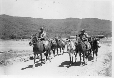
Photo - Pack horses leaving Mt Beauty
Farmers from the Kiewa Valley drove their cattle up to the Bogong High Plains during summer. Each family had a lease and a hut to stay in. Pack horses were used to carry food and other necessary items for the men while they were away.The Ryder family farmed in the Kiewa Valley and had a grazing lease and hut on the Bogong High Plains where they droe their cattle during summer. Black and white photo with 2 men on horses each followed by two packhorses. Wally Ryder is on the horseman on the right. January 1947. This photo is published on page 114 of 'A History of the Kiewa Valley' by Esther Temple and David Lloyd.On back 'Pack horses leaving Mt Beauty / January 1947 / Suspect Wally Ryder on right.'wally ryder, cattlemen, packhorses -
 Kiewa Valley Historical Society
Letter & Envelope - Kiewa Valley Rifle Club
The Kiewa Valley Rifle Club belonged to the Australian Rifle Clubs. They were in Military District No. 304 and operated as early as the 1920's. In 1876, an Australian Rifle Team, consisting of shooters from N.S.W. and Victoria, was the first team ever to officially represent Australia in any sport in international competition. In 1885, the first civilian Rifle Club was formed. After 1901 Rifle Clubs came under army control. In 1921, they were reconstituted as a purely civilian organisation where they have remained ever since.This letter is evidence that the Kiewa Valley Rifle Club existed in 1946 enabling its members to participate in a sport that had 12232 members and 313 Rifle Clubs in Victoria by 1939.Letter- Dated: May 9th 1946 from Acting Secretary, A. Jordan of Victorian Rifle Association re requirements of Rifle Clubs. Black type on yellowed paper. Folded horizontally in half and then into thirds. Envelope: Greenish yellow addressed to "The Captain or Secretary / Kiewa Valley Rifle Club / Kiewa / Vic. dated 13 May 1946 from Melbourne with a 1d and halfpenny Australian stamp. kiewa valley. rifle club. community. -
 Kiewa Valley Historical Society
Postcard - Junction Dam - Circa 1950, Circa 1950's
This postcard was produced in the 1950's for the tourist trade in the Kiewa Valley and Alpine region. It encompasses the period when the State of Victoria was pressured by the ever increasing demand by industry and its population for electricity supplies. Hydro electricity was seen as an untapped natural resource to quench this demand. The Victorian Alps and the rivers flowing into its valleys was ideal for the construction of the Kiewa Hydro Electricity Scheme. The late 1940's saw the development of this scheme and the changing of sections of alpine landscape is covered by this and other postcards/pictures (tourists, construction workers, and established rural populations). This period in time was before the established wildlife and forest/nature groups became political activist who changed legislative acts to protect the environment.This rural region (Kiewa Valley/alpine plains) was at most only significant to a smaller group of winter sports, summer hikers/horse riders and rural farmers/graziers. The numbers of tourists and the increase in the local resident population was boosted by the construction of the Hydro Electricity Scheme. This influx to the regional population resulted in a corresponding diversity in services and brought about an environment that responded to a growing level of tourists and thereby permitting this industry to grow more rapidly than it would have naturally. This postcard details an attraction to the "cleaner" method of providing electricity. This postcard was purchased in 1950 by a surveyor at Landford's Gap.This black and white photograph is a Valentine's postcard, from a V2 Argus photograph. It is on a 200g/m paper density with only the photo side gloss.Front "JUNCTION DAM & SPILLWAY, BOGONG KIEWA HYDRO-ELECTRIC PROJECT" on the flip side "VALENTINE'S POST CARD " "A GENUINE PHOTOGRAPH"kiewa valley tourism, victorian alps, alternate energy supplies, alpine population growth, junction dam, secv -
 Kiewa Valley Historical Society
Photos - Kiewa Hydro Electric Scheme - Bogong, Official S.E.C.V. photos
Kiewa Hydro Electric Scheme Bogong Area -
 Kiewa Valley Historical Society
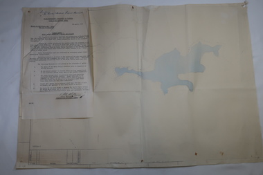
Plan Ref. K. 6612 with Letter attached re Public Safety in Kiewa Works Area
The SECV constructed the Kiewa Hydro Electric Scheme which included the building of Rocky Valley Dam on the Bogong High Plains near Falls Creek. H.H.C. Williams, construction engineer, Kiewa wrote to the Ski Clubs at Falls Creek outlining the dangers arising with the filling of Rocky Valley Dam. He lists 5 warnings in the interest of safety.The plan and letter provide the dates for the completion of Rocky Valley dam and its effect on the people living and working in the area including miners and ski clubs. It describes some of the features of Kiewa Works Area at the time.Plan No. K 6612 of Fall Creek showing Rocky Valley Dam's shape when it is full. Letter dated 6th April 1959 from H.H.C. Williams to Ski Clubs at Falls Creek re public safety as Rocky Valley fills. Refers to roads, transmission lines, pole lines etc in the Kiewa Works Area.Written in ink at top of letter - "Secretary / Mt Beauty and District Progress Association"rocky valley dam, falls creek ski clubs, h.h.c. williams, khes 1959, safety -
 Kiewa Valley Historical Society
West Kiewa Alpine Way and Day Ski Resort
In June 1982 This research report on the West Kiewa Alpine Way Proposal was sent to the Mt Beauty Chamber of Commerce. "The economic, tourist market and geographic factors are the kernel of the proposal." From Industrial Relocations Consultants Pty. Ltd.The proposal was to benefit the tourism industry.Manila foolscap folder with metal fastener. Papers dated June 1982 re - "Proposed West Kiewa Alpine Way and Day Ski Resort" Also enclosed but not related: Letter from Falls Creek Tourist Area Management Committee July 1984B. Goss written on coverwest kiewa alpine way, day ski resort, mt beauty chamber of commerce -
 Kiewa Valley Historical Society
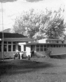
Photo - Tawonga South Primary School
Original site of the Tawonga South Primary School. Building is now used as Parks Victoria officesEarly site of Tawonga South Primary SchoolBlack and white photograph of original Tawonga South Primary Schooltawonga south primary school, state school, kiewa valley -
 Kiewa Valley Historical Society
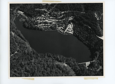
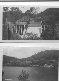
Two black and white photos, Photo downstream view of Junction Dam Wall and photo of Bogong Village and Lake Guy, c1950
Photo No. 1 - Junction Dam wall was commenced in February, 1940 and completed in March 1944. Type - reinforced concrete slab and buttress. Height 25.9m, and crest length 121.9m. Lewis Construction company had the original contract, but was replaced by the State Electricity Commission in 1942. Photo No. 2 - Bogong Village was the first village built to house workers and their families working on the Hydro electric scheme. Construction commenced 1940. The single men's quarters are slightly right of centre on the foreshore. Lake Guy was named after a former resident engineer.Shows the type of terrain where the village is located resulting in the tiered layout that was necessary in order to erect housing.set of 2 black and white photos - Photo No. 1 - downstream view of Junction Dam Wall Photo No. 2 - Lake Guy and Bogong Village. Both are on photographic paperPhoto No. 1 - Upper right hand corner, back of photo, handwritten in ink or biro, Bogong 1950 Photo No. 2 - Left lower corner, front of photo in white, Bogong.bogong village, lake guy, secv -
 Kiewa Valley Historical Society
Set of 2 hand coloured photographs of early Mount Beauty, photographs of Mount Beauty, 1947/48
Construction of the town of Mount Beauty commenced in 1946 and continued until 1952. It was built to provide family accommodation for workers engaged in the construction of the hydro electric power scheme. As well as housing, there was an administration building, staff hostel, merchandising centre, workmen's camps, base stores and workshops and the Mount Beauty Terminal Station. The first house was occupied in November, 1946 by the then manager of the trading store, with a frontage onto Hollonds Street. The total number of houses erected was 488, 162 custom built and 326 prefabricated. The main workmen's camp can be seen just left of the centre of the photograph and accommodated 144 men at the time of the photograph. By 1950 it could accommodate 1200men. Photo No. 1 is taken in 1947/early 1948 as there is no evidence of the staff hostel under construction. This hostel was commenced in August/September 1948 and is clearly shown in photograph No. 2, dating this photo as 1948 as it is before the completion of the bypass road connecting to the main (high plains) road. This road was constructed in 1939 and in 1948 followed the route of Tawonga Crescent. This remained in use until the bypass construction was completed in early 1949 and does not appear to be finished in this photograph.. Both photographs are taken from the power line easement adjacent to the Bright road.Significant historical pictorial record of the development of a town from grazing land. The type of terrain that had to be surveyed and then to construct roads and other infrastructure, with very little machinery, is also of prime significance in the development of the Kiewa Hydro Electric Scheme.Two photographs, both hand painted to show colours, and both of Mount Beauty c 1947/48 not long after commencement of construction of homes and facilities for workers.Photo No.1 - on back of photo, left upper corner, faintly in pencil, SPIKE, underneath this is written T Pay,. Photo No. 2 - on back of photo, left upper corner, faintly in pencil, Jmount beauty, housing, accommodation