Showing 331 items
matching research park
-
 Kew Historical Society Inc
Archive (Sub-series) - Subject File, Kew Historical Society, HOWARD family, 1970
Various partiesReference, Research, InformationSecondary Values (KHS Imposed Order)The subject file contains a single 3-page document donated by Mr A Atkyns containing his research on the Howard family of United Kingdom and Australia. The main point of interest in the file is the references to Frederick William Howard who was an early landowner in Studley Park, in Kew. The file also lists the marriages of Howard children into other families such as the Cussens. The file includes a brief family tree.kew historical society - archives, kew - history, charles howard (1796-?), ship - sir godfrey webster, ship - james watt, howardville - preston (vic), elizabeth bennett, sarah pierce (?-1877), patrick e cussen, charles james howard, helen mcpherson, frederick william howard, kate alsop, amelia howard, rowland macarthur, edward cussen ormond howard, margaret alsop, anne howard, john alsop, emma sarah howard, edward augustus atkynskew historical society - archives, kew - history, charles howard (1796-?), ship - sir godfrey webster, ship - james watt, howardville - preston (vic), elizabeth bennett, sarah pierce (?-1877), patrick e cussen, charles james howard, helen mcpherson, frederick william howard, kate alsop, amelia howard, rowland macarthur, edward cussen ormond howard, margaret alsop, anne howard, john alsop, emma sarah howard, edward augustus atkyns -
Kew Historical Society Inc
Archive (series) - Subject File, Kew Historical Society et al, 'Iveagh', Studley Park Road, 1993
Various partiesReference, Research, InformationSecondary Values (KHS Imposed Order)Subject file containing a 16-page manuscript recording the history of Iveagh in Studley Park Road, Kew from the earliest land sales to the ownership of the house by the Pallottine Fathers. Jean-Marie Labdanum and Dorothy Lyons created the manuscript in 1993 as part of a school research project. [There is also an article in KHS Newsletter 107, June 2014 by Kerry Fairbank on the history of the building].kew historical society - archives, kew - history, pallotine fathers, iveagh - 169 studley park road - kew (vic), john bakewell, richard goldsborough, william de graves, john mckenzie, john miller, thomas greenwood, thomas nankivell, george ramsden, patrick mcginnis, studley heights estatekew historical society - archives, kew - history, pallotine fathers, iveagh - 169 studley park road - kew (vic), john bakewell, richard goldsborough, william de graves, john mckenzie, john miller, thomas greenwood, thomas nankivell, george ramsden, patrick mcginnis, studley heights estate -
Kew Historical Society Inc
Archive (series) - Subject File, Kew Historical Society, JELLIS, Thomas G, 1958
Various partiesReference, Research, InformationSecondary Values (KHS Imposed Order)Subject file containing research and primary sources relating to T.G. Jellis and his family bakery in High Street, and later Studley Park Road, Kew. It includes a 1-page summary compiled by Elizabeth Mackie of an interview with his daughter Mrs Whitney, which was separately recorded on tape. A later document is a reminiscence of the bakery in Studley Park Road by Trevor D. Fiander of Ballan. This document includes drawings of the exterior and interior. [An article on the bakery can also be accessed in KHS Newsletter No.104 September 2013.kew historical society - archives, kew - history, t.g. jellis, mayors of kew - t.g. jellis, bakeries - kew (vic), mrs whitney (1895-?), trevor fianderkew historical society - archives, kew - history, t.g. jellis, mayors of kew - t.g. jellis, bakeries - kew (vic), mrs whitney (1895-?), trevor fiander -
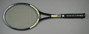 Tennis Australia
Racquet, Circa 1977
A Tremont Research Centre 'MAG-1' T201 model tennis racquet, with open throat; handle wrapped in leather, and a plastic butt cap with adhesive label. On base of head states: 'STRUCTURAL FOAM...MAG-1...GRAPHITE COMPOSITE'. On lower shaft states; 'T201' and a 'T' logo. Sticker on butt cap states: 'MAG-1'. Along edge of shaft are manufacturer details. Materials: Adhesive tape, Vinyl, Plastic, Ink, Leather, Adhesive label, Graphitetennis -
Kew Historical Society Inc
Journal, Kew Historical Society, Newsletter No.107, June 2014
Kew From Above [aerial photography] / Robert Baker p1. Society Activities: Exhibitions [Kew From Above, Model Kew Kitchen of the 1920s]; Quarterly book sale; New members; Past meetings; Recognition for Dorothy Benyei [archivist]; Future meetings; Tribute [Millicent Lindsay] / p3. National Bank of Australasia 'Signature Books' / Robert Baker p4 The Salvation Army in Kew / p5. Uncovering a hidden house ['Mount Eri', 9 Highbury Grove] / Robert Baker p5. Council Family Hotel / Robert Baker p6-7 New acquisitions / Robert Baker p7. 'Coonoor', 85 Studley Park Road / Kerry Fairbank p8-10. News from the past [150-years ago, 100-years ago]/ p10. Support Kew's History / p11. Ordsall-Southesk / Robert Baker / p12Published quarterly since 1977, the newsletters of the Kew Historical Society contain significant research by members exploring relevant aspects of the Victorian and Australian Framework of Historical Themes. Frequently, articles on people, places and artefacts are the only source of information about an aspect of Kew, and Melbourne’s history.non-fictionKew From Above [aerial photography] / Robert Baker p1. Society Activities: Exhibitions [Kew From Above, Model Kew Kitchen of the 1920s]; Quarterly book sale; New members; Past meetings; Recognition for Dorothy Benyei [archivist]; Future meetings; Tribute [Millicent Lindsay] / p3. National Bank of Australasia 'Signature Books' / Robert Baker p4 The Salvation Army in Kew / p5. Uncovering a hidden house ['Mount Eri', 9 Highbury Grove] / Robert Baker p5. Council Family Hotel / Robert Baker p6-7 New acquisitions / Robert Baker p7. 'Coonoor', 85 Studley Park Road / Kerry Fairbank p8-10. News from the past [150-years ago, 100-years ago]/ p10. Support Kew's History / p11. Ordsall-Southesk / Robert Baker / p12kew historical society (vic.) -- periodicals., kew historical society (vic.) -- newsletters, kew historical society (vic.) -- journals -
Kew Historical Society Inc
Journal, Kew Historical Society, Newsletter No.104, September 2013
Five Ways [Kew Junction] / Robert Baker p1-2. Society Activities - KHS Members [Dorothy Benyei, Don Garden]; Exhibitions [Trinity Grammar School, Kew High School]; Past Meetings; Future Meetings; Then and now / p3. Gallipoli and Beyond [100th Anniversary commemorations] / p4. Churches of Kew - the first St Hilary's / Dione McIntyre / p3. The Clifton Hotel / Robert Baker p4. Being Involved [Collections & collecting] / Robert Baker p6. History at the Cemetery [Kew High School tour] / p6. [Vale] Eric Sibly / Tony Michael p6. A message from one of our members about the Kew War Memorial / John Hood p6. Jellis' Bakeries / Robert Baker p7-8. Glencara, Studley Park Road / Kerry Fairbank p9-10. Support Kew's History / p10. AGM advice and forms / p10-11. Book Sale / p12. Name the building / p12.Published quarterly since 1977, the newsletters of the Kew Historical Society contain significant research by members exploring relevant aspects of the Victorian and Australian Framework of Historical Themes. Frequently, articles on people, places and artefacts are the only source of information about an aspect of Kew, and Melbourne’s history.non-fictionFive Ways [Kew Junction] / Robert Baker p1-2. Society Activities - KHS Members [Dorothy Benyei, Don Garden]; Exhibitions [Trinity Grammar School, Kew High School]; Past Meetings; Future Meetings; Then and now / p3. Gallipoli and Beyond [100th Anniversary commemorations] / p4. Churches of Kew - the first St Hilary's / Dione McIntyre / p3. The Clifton Hotel / Robert Baker p4. Being Involved [Collections & collecting] / Robert Baker p6. History at the Cemetery [Kew High School tour] / p6. [Vale] Eric Sibly / Tony Michael p6. A message from one of our members about the Kew War Memorial / John Hood p6. Jellis' Bakeries / Robert Baker p7-8. Glencara, Studley Park Road / Kerry Fairbank p9-10. Support Kew's History / p10. AGM advice and forms / p10-11. Book Sale / p12. Name the building / p12.kew historical society (vic.) -- periodicals., kew historical society (vic.) -- newsletters, kew historical society (vic.) -- journals -
Kew Historical Society Inc
Journal, The Kewriosity Sheet Vol.1 No.3 : August 1979
What's doing in Kew for August / p1. We want your news! / p1. Kew Municipal Library: Where children are VIP / p1. 25 years of service: Kew Lions Anniversary / p1. Miss Shepheard retires [Stawell Street Kindergarten] / p1. Studley Park Progress Association / p1. Entertainers needed [Kew Entertainment Workshop] / p1. Rotaract ski weekend / p1. Kew Historical Society: Memorials in Kew / p2. Children's Week 1979 / p2. Limerick of the month / p2. Theatre in Education [Kew High School] / p2. Nursing Mothers Association / p2. Mid-week tennis / p2. [Kew] Swimming Club / p2. Help where it's needed [Sacred Heart Kew Caring Group] / p2. Kew City Bowmen / p2. Holiday help [Meals on Wheels] / p2. Child Development Seminar / p2. Council News: For your safety [Roundabouts; If you're un-building [demolitions]; Traffic School; School Holidays] / p2. Citizens' Advice Bureau / p2.The Kewriosity Sheet (1979-83) was first published in the City of Kew (Victoria) in June 1979 as a two-sided 'community newssheet'. It aimed to: 'share news about Kew happenings and Kew people, and to exchange ideas about living in Kew'. Later issues gradually evolved into a 4-page, quarto sized publication. The Kewriosity Sheet was superseded by the Kew Council publication 'Kewriosity' (1983-1994).non-fictionWhat's doing in Kew for August / p1. We want your news! / p1. Kew Municipal Library: Where children are VIP / p1. 25 years of service: Kew Lions Anniversary / p1. Miss Shepheard retires [Stawell Street Kindergarten] / p1. Studley Park Progress Association / p1. Entertainers needed [Kew Entertainment Workshop] / p1. Rotaract ski weekend / p1. Kew Historical Society: Memorials in Kew / p2. Children's Week 1979 / p2. Limerick of the month / p2. Theatre in Education [Kew High School] / p2. Nursing Mothers Association / p2. Mid-week tennis / p2. [Kew] Swimming Club / p2. Help where it's needed [Sacred Heart Kew Caring Group] / p2. Kew City Bowmen / p2. Holiday help [Meals on Wheels] / p2. Child Development Seminar / p2. Council News: For your safety [Roundabouts; If you're un-building [demolitions]; Traffic School; School Holidays] / p2. Citizens' Advice Bureau / p2. community publications --- kew (vic.), the kewriosity sheet, newsletters - kew (vic.) -
Kew Historical Society Inc
Journal, The Kewriosity Sheet Vol.1 No.5 : October 1979
What's doing in Kew for October / p1. Keeping Kew beautiful [Parks and Gardens: Alexandra Gardens - Kew; Kew Garden Club; Willsmere Park; Victoria Park; Eglinton Reserve] / p1. Your news is good news / p1. Got some spare time [Henry Pride] / p1. Young people's club [Fitzwilliam Street People's Church] / p1. Fun and fellowship [Kew Uniting Church Youth Group] / p1. Learn to swim next year! / p1. Bring your orchid [Kew Garden Club] / p2. Retired and looking for something to do? [Kew Elder Citizens] / p2. Your help needed [The Kewriosity Sheet] / p2. [Aphorisms] / p2. Songs my mother sang / p2. Recreation courses / p2. Multiple Sclerosis Unit / p2. You you get ideas? [East Kew Uniting Church] / p2. E.P.R.G. (Early Planning for Retirement Group] / p2. Mum - It's for you! / p2. Action for the handicapped / p2. Biggest rug in the world / p2. Council News [City Hall Bookings; Town Planning; Unburnable rubbish; Family Day Care Scheme; Community Occupational Therapist; Kew Community Directory; Come meet your Mayor (Cr Kaye Cole) / p2. Do it yourself duplicating [Copy Shop] / p2. Meals on - tables [Kew Elderly Citizens' Club] / p2.The Kewriosity Sheet (1979-83) was first published in the City of Kew (Victoria) in June 1979 as a two-sided 'community newssheet'. It aimed to: 'share news about Kew happenings and Kew people, and to exchange ideas about living in Kew'. Later issues gradually evolved into a 4-page, quarto sized publication. The Kewriosity Sheet was superseded by the Kew Council publication 'Kewriosity' (1983-1994).non-fictionWhat's doing in Kew for October / p1. Keeping Kew beautiful [Parks and Gardens: Alexandra Gardens - Kew; Kew Garden Club; Willsmere Park; Victoria Park; Eglinton Reserve] / p1. Your news is good news / p1. Got some spare time [Henry Pride] / p1. Young people's club [Fitzwilliam Street People's Church] / p1. Fun and fellowship [Kew Uniting Church Youth Group] / p1. Learn to swim next year! / p1. Bring your orchid [Kew Garden Club] / p2. Retired and looking for something to do? [Kew Elder Citizens] / p2. Your help needed [The Kewriosity Sheet] / p2. [Aphorisms] / p2. Songs my mother sang / p2. Recreation courses / p2. Multiple Sclerosis Unit / p2. You you get ideas? [East Kew Uniting Church] / p2. E.P.R.G. (Early Planning for Retirement Group] / p2. Mum - It's for you! / p2. Action for the handicapped / p2. Biggest rug in the world / p2. Council News [City Hall Bookings; Town Planning; Unburnable rubbish; Family Day Care Scheme; Community Occupational Therapist; Kew Community Directory; Come meet your Mayor (Cr Kaye Cole) / p2. Do it yourself duplicating [Copy Shop] / p2. Meals on - tables [Kew Elderly Citizens' Club] / p2. community publications --- kew (vic.), the kewriosity sheet, newsletters - kew (vic.) -
Kew Historical Society Inc
Journal, The Kewriosity Sheet Vol.1 No.6 : November 1979
What's doing in Kew for November / p1. Evaluation time! [Survey: The Kewriosity Sheet] / p1. Your news is good news / p1. Kew Op Shop / p1. Do it yourself duplicating [The Copy Shop] / p1. Toastmasters Club commences in Kew / p2. Hey kids!! Did you know? / p2. Park is beautiful asset [Yarra Bend Park; Studley Park Progress Association] / p2. Jobs wanted / p2. Kew Philharmonic Society / p2. Eat Kew Primary School [Reading; Concert Band] / p2. Playgroup [Uniting Church Highbury Grove] / p2. Show, Sell and Tell night [Gardening] / p2. Council News [Home help; A new group in Kew; Swimming Pool; Immunisations; Dog registrations; Valuations; Rates] / p2.The Kewriosity Sheet (1979-83) was first published in the City of Kew (Victoria) in June 1979 as a two-sided 'community newssheet'. It aimed to: 'share news about Kew happenings and Kew people, and to exchange ideas about living in Kew'. Later issues gradually evolved into a 4-page, quarto sized publication. The Kewriosity Sheet was superseded by the Kew Council publication 'Kewriosity' (1983-1994).non-fictionWhat's doing in Kew for November / p1. Evaluation time! [Survey: The Kewriosity Sheet] / p1. Your news is good news / p1. Kew Op Shop / p1. Do it yourself duplicating [The Copy Shop] / p1. Toastmasters Club commences in Kew / p2. Hey kids!! Did you know? / p2. Park is beautiful asset [Yarra Bend Park; Studley Park Progress Association] / p2. Jobs wanted / p2. Kew Philharmonic Society / p2. Eat Kew Primary School [Reading; Concert Band] / p2. Playgroup [Uniting Church Highbury Grove] / p2. Show, Sell and Tell night [Gardening] / p2. Council News [Home help; A new group in Kew; Swimming Pool; Immunisations; Dog registrations; Valuations; Rates] / p2.community publications --- kew (vic.), the kewriosity sheet, newsletters - kew (vic.) -
Kew Historical Society Inc
Journal, The Kewriosity Sheet Vol.1 No.9 : February 1980
What's doing in Kew for February / p1. Work Program: Kew Employment Project - Work, training and guidance / p1. Unemployment problems / Jim Fyfe p1. Will you help? [Henry Pride Volunteer Service] / p2. Historical Society / Elizabeth Mackie p2. Henry Pride Centre - Studley Park - Weekly Church Services / p2. The Kintore Social Club / p2. An Association of Relatives and Friends of the Emotionally Ill (A.R.A.F.E.M.I) / p2. C.R.B. - Country Roads Board Route E6 public display / p2. Limericks / p2. Council News [Council Meeting Dates 1980; Open Mayor's Room] / p2. Evaluation!! - Evaluation of Kewriosity Sheet] / p2. Meals on Wheels / p2.The Kewriosity Sheet (1979-83) was first published in the City of Kew (Victoria) in June 1979 as a two-sided 'community newssheet'. It aimed to: 'share news about Kew happenings and Kew people, and to exchange ideas about living in Kew'. Later issues gradually evolved into a 4-page, quarto sized publication. The Kewriosity Sheet was superseded by the Kew Council publication 'Kewriosity' (1983-1994).non-fictionWhat's doing in Kew for February / p1. Work Program: Kew Employment Project - Work, training and guidance / p1. Unemployment problems / Jim Fyfe p1. Will you help? [Henry Pride Volunteer Service] / p2. Historical Society / Elizabeth Mackie p2. Henry Pride Centre - Studley Park - Weekly Church Services / p2. The Kintore Social Club / p2. An Association of Relatives and Friends of the Emotionally Ill (A.R.A.F.E.M.I) / p2. C.R.B. - Country Roads Board Route E6 public display / p2. Limericks / p2. Council News [Council Meeting Dates 1980; Open Mayor's Room] / p2. Evaluation!! - Evaluation of Kewriosity Sheet] / p2. Meals on Wheels / p2. community publications --- kew (vic.), the kewriosity sheet, newsletters - kew (vic.) -
Kew Historical Society Inc
Journal, The Kewriosity Sheet Vol.2 No.1 : June 1980
What's doing in Kew for June / p1. Q Crop [Youth Group, Holy Trinity Church of England Kew.] / p1. All day and long term parking for the Fenton Ave. Car Park - Kew Junction Shopping Centre / p1. Where to pick up your Kewriosity Sheet / p1. Henry Pride Volunteer Service / Mrs Jean Oswald p1. Your news is good news / p1. Kew Op Shop / p1. Do it yourself duplication [The Copy Shop] / p1. What do you do if no-one seems to have the right answer? [Citizens' Advice Bureau] p1. Kew Historical Society / p2. The friendly stranger [Stranger danger] / p2. Swimming - even in the Winter! / Maureen Meyers p2. Backgammon [Kew Backgammon Club] / p2. Diplomacy [Decision Games] / p2. 'Anything Goes [Cole Porter, Starlight Theatrical Co.] / p2. Kew Croquet Club / p2. Family tea – "Indian Style" [East Kew Baptist Church] p2. Playgroup [Uniting Church , Highbury Grove] / p2. Youth Clubs [St Hilary’s Church of England] / p2. Nominations for Council [Cr Robert Pritchard, Cr Phyllis Hore, Cr Jack Gervasoni, Cr Jack Ryan, Cr.Walter Haldun / p3. Appointment of traffic engineering consultant. [DT Grogan & Associates] / p2.The Kewriosity Sheet (1979-83) was first published in the City of Kew (Victoria) in June 1979 as a two-sided 'community newssheet'. It aimed to: 'share news about Kew happenings and Kew people, and to exchange ideas about living in Kew'. Later issues gradually evolved into a 4-page, quarto sized publication. The Kewriosity Sheet was superseded by the Kew Council publication 'Kewriosity' (1983-1994).non-fictionWhat's doing in Kew for June / p1. Q Crop [Youth Group, Holy Trinity Church of England Kew.] / p1. All day and long term parking for the Fenton Ave. Car Park - Kew Junction Shopping Centre / p1. Where to pick up your Kewriosity Sheet / p1. Henry Pride Volunteer Service / Mrs Jean Oswald p1. Your news is good news / p1. Kew Op Shop / p1. Do it yourself duplication [The Copy Shop] / p1. What do you do if no-one seems to have the right answer? [Citizens' Advice Bureau] p1. Kew Historical Society / p2. The friendly stranger [Stranger danger] / p2. Swimming - even in the Winter! / Maureen Meyers p2. Backgammon [Kew Backgammon Club] / p2. Diplomacy [Decision Games] / p2. 'Anything Goes [Cole Porter, Starlight Theatrical Co.] / p2. Kew Croquet Club / p2. Family tea – "Indian Style" [East Kew Baptist Church] p2. Playgroup [Uniting Church , Highbury Grove] / p2. Youth Clubs [St Hilary’s Church of England] / p2. Nominations for Council [Cr Robert Pritchard, Cr Phyllis Hore, Cr Jack Gervasoni, Cr Jack Ryan, Cr.Walter Haldun / p3. Appointment of traffic engineering consultant. [DT Grogan & Associates] / p2. community publications --- kew (vic.), the kewriosity sheet, newsletters - kew (vic.) -
Kew Historical Society Inc
Journal, The Kewriosity Sheet Vol.2 No.3 : August 1980
What's doing in Kew for August / p1. Kew Historical Society [George Allan WW2 memorial; Kew Library] / Mavis Rolley p1. St Anne's School - East Kew [50th anniversary of laying of foundation stone] / p1. Epilepsy month / p1. Studley Park Progress Association [Yarra River, Environmental conservation] / Marshall Slattery p2. Greenacres Golf Club / p1. St Hilary's Youth Club / p1. Kintore Social Club / p2. Early landmark of Kew [Kew Court House; Kew Post Office] / Elizabeth Mackie p2. Kew Garden Club / p2. Bowling Club nears century [Kew Bowling Club] / p2.Council News [Kindergarten enrolments; Funds available for local groups; Promoting Kew; Entertainment in Parks; What is R.A.A.V? (Rheumatism and Arthritis Association of Victoria)] / p2. Where have all the people gone? / Rev Stan Simmons p2. Scrabble [Kew Scrabble Club] / p2. Kew & Hawthorn Citizens' Advice Bureau / p2.The Kewriosity Sheet (1979-83) was first published in the City of Kew (Victoria) in June 1979 as a two-sided 'community newssheet'. It aimed to: 'share news about Kew happenings and Kew people, and to exchange ideas about living in Kew'. Later issues gradually evolved into a 4-page, quarto sized publication. The Kewriosity Sheet was superseded by the Kew Council publication 'Kewriosity' (1983-1994).non-fictionWhat's doing in Kew for August / p1. Kew Historical Society [George Allan WW2 memorial; Kew Library] / Mavis Rolley p1. St Anne's School - East Kew [50th anniversary of laying of foundation stone] / p1. Epilepsy month / p1. Studley Park Progress Association [Yarra River, Environmental conservation] / Marshall Slattery p2. Greenacres Golf Club / p1. St Hilary's Youth Club / p1. Kintore Social Club / p2. Early landmark of Kew [Kew Court House; Kew Post Office] / Elizabeth Mackie p2. Kew Garden Club / p2. Bowling Club nears century [Kew Bowling Club] / p2.Council News [Kindergarten enrolments; Funds available for local groups; Promoting Kew; Entertainment in Parks; What is R.A.A.V? (Rheumatism and Arthritis Association of Victoria)] / p2. Where have all the people gone? / Rev Stan Simmons p2. Scrabble [Kew Scrabble Club] / p2. Kew & Hawthorn Citizens' Advice Bureau / p2. community publications --- kew (vic.), the kewriosity sheet, newsletters - kew (vic.) -
Kew Historical Society Inc
Journal, The Kewriosity Sheet Vol.2 No.9 : March 1981
[Kew] Festival issue [programme] / p1&2. Typical craft work of the colonial period [Stefan Nechwatal] / p1. Festival photo competition / p2. What's doing in Kew for March / p2&3. The Alexandra Gardens / Elizabeth Mackie p3. Hyde Park Fellowship / p3. English classes for migrant women [Denmark Street Baby Health Centre] / p4. Citizens' Advice Bureau [International Year of the Disabled Person] / p4. Full participation and equality / [Disability; Rheumatism & Arthritis Association of Victoria] / M.J. Meyers p4.The Kewriosity Sheet (1979-83) was first published in the City of Kew (Victoria) in June 1979 as a two-sided 'community newssheet'. It aimed to: 'share news about Kew happenings and Kew people, and to exchange ideas about living in Kew'. Later issues gradually evolved into a 4-page, quarto sized publication. The Kewriosity Sheet was superseded by the Kew Council publication 'Kewriosity' (1983-1994).non-fiction[Kew] Festival issue [programme] / p1&2. Typical craft work of the colonial period [Stefan Nechwatal] / p1. Festival photo competition / p2. What's doing in Kew for March / p2&3. The Alexandra Gardens / Elizabeth Mackie p3. Hyde Park Fellowship / p3. English classes for migrant women [Denmark Street Baby Health Centre] / p4. Citizens' Advice Bureau [International Year of the Disabled Person] / p4. Full participation and equality / [Disability; Rheumatism & Arthritis Association of Victoria] / M.J. Meyers p4. community publications --- kew (vic.), the kewriosity sheet, newsletters - kew (vic.) -
Kew Historical Society Inc
Journal, The Kewriosity Sheet Vol.2 No.11 : May 1981
The Duke of Edinburgh's Award Scheme / p1. How Red Cross helps [Trinity Grammar School Past Parents' Group] / p1. Backgammon [Eastern Bridge Studios] / p1. Scrabble / p1. News from East Kew Uniting Church / p2. Hyde Park Fellowship [refugees] / p2. What's doing in Kew for May / p2&3. Kew Uniting Church Highbury Grove / p3. Wanted [Volunteers; Kew Citizens' Advice Bureau] / p3. The Copy Shop / p3. Council News - City of Kew Cultural & Charity Grant; May School Holiday tentative programme; Playcentre; Films; Kew Traffic School; Toddler Playgroups [The Uniting Church of Kew] / p4. Milking time in Kew [Watson's Dairy; Milk and Dairy Supervision Act] / Elizabeth Mackie p4.The Kewriosity Sheet (1979-83) was first published in the City of Kew (Victoria) in June 1979 as a two-sided 'community newssheet'. It aimed to: 'share news about Kew happenings and Kew people, and to exchange ideas about living in Kew'. Later issues gradually evolved into a 4-page, quarto sized publication. The Kewriosity Sheet was superseded by the Kew Council publication 'Kewriosity' (1983-1994).non-fictionThe Duke of Edinburgh's Award Scheme / p1. How Red Cross helps [Trinity Grammar School Past Parents' Group] / p1. Backgammon [Eastern Bridge Studios] / p1. Scrabble / p1. News from East Kew Uniting Church / p2. Hyde Park Fellowship [refugees] / p2. What's doing in Kew for May / p2&3. Kew Uniting Church Highbury Grove / p3. Wanted [Volunteers; Kew Citizens' Advice Bureau] / p3. The Copy Shop / p3. Council News - City of Kew Cultural & Charity Grant; May School Holiday tentative programme; Playcentre; Films; Kew Traffic School; Toddler Playgroups [The Uniting Church of Kew] / p4. Milking time in Kew [Watson's Dairy; Milk and Dairy Supervision Act] / Elizabeth Mackie p4. community publications --- kew (vic.), the kewriosity sheet, newsletters - kew (vic.) -
Kew Historical Society Inc
Journal, The Kewriosity Sheet Vol.3 No.2 : August 1981
Hyde Park Fellowship [Hyde Park Church] / p1. Don't forget the blitz [Yarra Bend Park; South African Boneweed] / p1. Kew Birdwatching Group / p1. Sacred Heart [Church] Diamond Julbilee / p1. City of Kew Annual Election: Prospect Ward [Kaye Cole; John Douglas Ryan] / p1. Kew Philharmonic Society / p1. C.A.B. Citizens Advice Bureau / p1. Institute of Early Childhood Development / p2. What's doing in Kew for August / p2&3. Kagya Dharma has variety of classes / p3. The fun service club for the young [Rotaract] / p3. 1875 Historic old map of Kew [Dannock Map; Kew Historical Society] / Elizabeth Mackie p4. Don't tell me you're too old [recreation] / p3. Council News [Holiday Programme; Holiday Playcentre; Film; Toddler Playgroup; Traffic School; New Games Trailer; Teenage Dropin Centre] / p4.The Kewriosity Sheet (1979-83) was first published in the City of Kew (Victoria) in June 1979 as a two-sided 'community newssheet'. It aimed to: 'share news about Kew happenings and Kew people, and to exchange ideas about living in Kew'. Later issues gradually evolved into a 4-page, quarto sized publication. The Kewriosity Sheet was superseded by the Kew Council publication 'Kewriosity' (1983-1994).non-fictionHyde Park Fellowship [Hyde Park Church] / p1. Don't forget the blitz [Yarra Bend Park; South African Boneweed] / p1. Kew Birdwatching Group / p1. Sacred Heart [Church] Diamond Julbilee / p1. City of Kew Annual Election: Prospect Ward [Kaye Cole; John Douglas Ryan] / p1. Kew Philharmonic Society / p1. C.A.B. Citizens Advice Bureau / p1. Institute of Early Childhood Development / p2. What's doing in Kew for August / p2&3. Kagya Dharma has variety of classes / p3. The fun service club for the young [Rotaract] / p3. 1875 Historic old map of Kew [Dannock Map; Kew Historical Society] / Elizabeth Mackie p4. Don't tell me you're too old [recreation] / p3. Council News [Holiday Programme; Holiday Playcentre; Film; Toddler Playgroup; Traffic School; New Games Trailer; Teenage Dropin Centre] / p4. community publications --- kew (vic.), the kewriosity sheet, newsletters - kew (vic.) -
Kew Historical Society Inc
Journal, The Kewriosity Sheet Vol.3 No.3 : September 1981
Home tutors for migrants [Jill Manton] / p1. Harp, Browse and Buy [Harp Browse and Buy Shop; Victoria Schizophrenia Fellowship] / p1. East Kew Uniting Church / p1. Spring-time Fair [East Kew Uniting Church] /p2. Do you know? [Parents of Disabled Persons] / p2. What's doing in Kew for September / p2&3 Women's Recreation Program /p3. Guest to preach at Kew Baptist Church [Rev. Brian Willersdorf] / p3. Minibus drivers and jockeys [Meals on Wheels] / p3. Hyde Park Fellowship [Hyde Park Church] / p3. Mission Spring Fair [Missionary Sisters of St Peter Claver / p3. The gateway to Kew [Charles Grimes Expedition; Johnston Street Bridge; Studley Park Road; Raheen; Campion Hall; Burke Hall; Studley House; Villa Alba] / Elizabeth Mackie p4. Council News - Family and Community Services (FACS) Programme; Community Service Grants; Deafness Awareness Week; ] / p4.The Kewriosity Sheet (1979-83) was first published in the City of Kew (Victoria) in June 1979 as a two-sided 'community newssheet'. It aimed to: 'share news about Kew happenings and Kew people, and to exchange ideas about living in Kew'. Later issues gradually evolved into a 4-page, quarto sized publication. The Kewriosity Sheet was superseded by the Kew Council publication 'Kewriosity' (1983-1994).non-fictionHome tutors for migrants [Jill Manton] / p1. Harp, Browse and Buy [Harp Browse and Buy Shop; Victoria Schizophrenia Fellowship] / p1. East Kew Uniting Church / p1. Spring-time Fair [East Kew Uniting Church] /p2. Do you know? [Parents of Disabled Persons] / p2. What's doing in Kew for September / p2&3 Women's Recreation Program /p3. Guest to preach at Kew Baptist Church [Rev. Brian Willersdorf] / p3. Minibus drivers and jockeys [Meals on Wheels] / p3. Hyde Park Fellowship [Hyde Park Church] / p3. Mission Spring Fair [Missionary Sisters of St Peter Claver / p3. The gateway to Kew [Charles Grimes Expedition; Johnston Street Bridge; Studley Park Road; Raheen; Campion Hall; Burke Hall; Studley House; Villa Alba] / Elizabeth Mackie p4. Council News - Family and Community Services (FACS) Programme; Community Service Grants; Deafness Awareness Week; ] / p4. community publications --- kew (vic.), the kewriosity sheet, newsletters - kew (vic.) -
Kew Historical Society Inc
Journal, The Kewriosity Sheet Vol.3 No.4 : October 1981
Do you know? [Citizens Advice Bureau] / p1. G.R.O.W. Comes to Kew [Mental health] / p1. Theatre luncheon / p1. Add your cents [Fundraising; Year of the Disabled] / p1. Car rally [St Peter Claver Mission] / p1. Hyde Park Fellowship [Hyde Park Church] / p2. Bush dance [East Kew Uniting Church] / p2. National Epilepsy Week / p2. What's doing in Kew for October / p2&3. The Op[portunity] Shop / p3. Music Makers Concert [Victorian Youth Symphonic Band; East Kew Primary School; Q.C. Brass; Kew Citizens Band; Foster Parents Hall] / p3. Scrabble / p3. Disabled Persons Parking Labels / p3. Guide to the 1875 Map of Kew / Elizabeth Mackie / p4.The Kewriosity Sheet (1979-83) was first published in the City of Kew (Victoria) in June 1979 as a two-sided 'community newssheet'. It aimed to: 'share news about Kew happenings and Kew people, and to exchange ideas about living in Kew'. Later issues gradually evolved into a 4-page, quarto sized publication. The Kewriosity Sheet was superseded by the Kew Council publication 'Kewriosity' (1983-1994).non-fictionDo you know? [Citizens Advice Bureau] / p1. G.R.O.W. Comes to Kew [Mental health] / p1. Theatre luncheon / p1. Add your cents [Fundraising; Year of the Disabled] / p1. Car rally [St Peter Claver Mission] / p1. Hyde Park Fellowship [Hyde Park Church] / p2. Bush dance [East Kew Uniting Church] / p2. National Epilepsy Week / p2. What's doing in Kew for October / p2&3. The Op[portunity] Shop / p3. Music Makers Concert [Victorian Youth Symphonic Band; East Kew Primary School; Q.C. Brass; Kew Citizens Band; Foster Parents Hall] / p3. Scrabble / p3. Disabled Persons Parking Labels / p3. Guide to the 1875 Map of Kew / Elizabeth Mackie / p4. community publications --- kew (vic.), the kewriosity sheet, newsletters - kew (vic.) -
Kew Historical Society Inc
Journal, The Kewriosity Sheet Vol.3 No.5 : November 1981
Have you an hour to spare? [Meals on Wheels; Kew Community Bus] / p1. Kew Library extended opening hours / p1. Apology [Citizens Advice Bureau] / p1. Historic local church celebrates its 125th anniversary [Kew Baptist Church] / p1&3. Hyde Park Fellowship [Hyde Park Church] / p2. 65th Church anniversary [Hyde Park Methodist Chuch] / p2. What's doing in Kew for November / p2&3. Mayoral neighbourhood gathering [Cr Martin Solomons] / p3. Christmas special [East Kew Uniting Church] / p3. The [1867] Great Feast in Kew / Elizabeth Mackie p4. The Lioness Club of Kew / p4. Fete [Rossboume House School] / p4. Fourth Kew Scouts [4th Kew Scouts; Glass Creek Scout Hall] / p4. La Verna Open Day / p4.The Kewriosity Sheet (1979-83) was first published in the City of Kew (Victoria) in June 1979 as a two-sided 'community newssheet'. It aimed to: 'share news about Kew happenings and Kew people, and to exchange ideas about living in Kew'. Later issues gradually evolved into a 4-page, quarto sized publication. The Kewriosity Sheet was superseded by the Kew Council publication 'Kewriosity' (1983-1994).non-fictionHave you an hour to spare? [Meals on Wheels; Kew Community Bus] / p1. Kew Library extended opening hours / p1. Apology [Citizens Advice Bureau] / p1. Historic local church celebrates its 125th anniversary [Kew Baptist Church] / p1&3. Hyde Park Fellowship [Hyde Park Church] / p2. 65th Church anniversary [Hyde Park Methodist Chuch] / p2. What's doing in Kew for November / p2&3. Mayoral neighbourhood gathering [Cr Martin Solomons] / p3. Christmas special [East Kew Uniting Church] / p3. The [1867] Great Feast in Kew / Elizabeth Mackie p4. The Lioness Club of Kew / p4. Fete [Rossboume House School] / p4. Fourth Kew Scouts [4th Kew Scouts; Glass Creek Scout Hall] / p4. La Verna Open Day / p4. community publications --- kew (vic.), the kewriosity sheet, newsletters - kew (vic.) -
Kew Historical Society Inc
Journal, The Kewriosity Sheet Vol.3 No.6 : December 1981
Council holiday programme / p1. Family neighbourhood b.b.q. [Cr Martin Solomons] / p1. Citizens Advice Bureau / p1. Kew Library new hours / p1. Kew City Council [new phone number] / p1. Kew Chess Club / p2. La Verna Open Day / p2. What's doing in Kew for December / p2&3. Fairyland in Kew / Elizabeth Mackie p3. Hyde Park Fellowship [Hyde Park Uniting Church] / p3. Any questions? Information available from Kew Historical Society / p4. Uniting Christmas Special [East Kew Uniting Church] / p4. Sunday Treasure Market [Kew Lions Club] / p4. GROW [programme of growth to maturity] / p4.The Kewriosity Sheet (1979-83) was first published in the City of Kew (Victoria) in June 1979 as a two-sided 'community newssheet'. It aimed to: 'share news about Kew happenings and Kew people, and to exchange ideas about living in Kew'. Later issues gradually evolved into a 4-page, quarto sized publication. The Kewriosity Sheet was superseded by the Kew Council publication 'Kewriosity' (1983-1994).non-fictionCouncil holiday programme / p1. Family neighbourhood b.b.q. [Cr Martin Solomons] / p1. Citizens Advice Bureau / p1. Kew Library new hours / p1. Kew City Council [new phone number] / p1. Kew Chess Club / p2. La Verna Open Day / p2. What's doing in Kew for December / p2&3. Fairyland in Kew / Elizabeth Mackie p3. Hyde Park Fellowship [Hyde Park Uniting Church] / p3. Any questions? Information available from Kew Historical Society / p4. Uniting Christmas Special [East Kew Uniting Church] / p4. Sunday Treasure Market [Kew Lions Club] / p4. GROW [programme of growth to maturity] / p4. community publications --- kew (vic.), the kewriosity sheet, newsletters - kew (vic.) -
Kew Historical Society Inc
Journal, The Kewriosity Sheet Vol.3 No.7 : February 1982
The doctors of Kew [Dr Edgar Inglis] / Elizabeth Mackie p1. Save the Children Fund / p2. Sunday treasure market / p2. What's doing in Kew for February / p2&3. Institute of Early Childhood Development - Short courses / p3. Synchronised swimming lessons / p3. Hyde Park Fellowship [Hyde Park Uniting Church] / p3. Scrabble / p3. Short story award [1982 Kew Community Festival] / p4. Uniting Church East Kew: Coming events for February / p4.The Kewriosity Sheet (1979-83) was first published in the City of Kew (Victoria) in June 1979 as a two-sided 'community newssheet'. It aimed to: 'share news about Kew happenings and Kew people, and to exchange ideas about living in Kew'. Later issues gradually evolved into a 4-page, quarto sized publication. The Kewriosity Sheet was superseded by the Kew Council publication 'Kewriosity' (1983-1994).non-fictionThe doctors of Kew [Dr Edgar Inglis] / Elizabeth Mackie p1. Save the Children Fund / p2. Sunday treasure market / p2. What's doing in Kew for February / p2&3. Institute of Early Childhood Development - Short courses / p3. Synchronised swimming lessons / p3. Hyde Park Fellowship [Hyde Park Uniting Church] / p3. Scrabble / p3. Short story award [1982 Kew Community Festival] / p4. Uniting Church East Kew: Coming events for February / p4.community publications --- kew (vic.), the kewriosity sheet, newsletters - kew (vic.) -
Kew Historical Society Inc
Journal, The Kewriosity Sheet Vol.3 No.8 : March 1982
Kew Festival - 19th - 28th March [programme] / p1&2-3. Pre-Festival event [Victorian Concert Orchestra] / p1.What's doing in Kew for March / p2&3. Helping people: Merlan Voluntary Services / p2. Hyde Park Fellowship [Hyde Park Uniting Church] / p2. Kew Historical Society / p3. New courses [Kew Uniting Church] / p4. Kew Philharmonic Orchestra / p4. Savoy Players / p4. Heritage Week Report [Kew Historical Society] / p4. Kew Garden Club / p4. Australian Association for Better Hearing / p4.The Kewriosity Sheet (1979-83) was first published in the City of Kew (Victoria) in June 1979 as a two-sided 'community newssheet'. It aimed to: 'share news about Kew happenings and Kew people, and to exchange ideas about living in Kew'. Later issues gradually evolved into a 4-page, quarto sized publication. The Kewriosity Sheet was superseded by the Kew Council publication 'Kewriosity' (1983-1994).non-fictionKew Festival - 19th - 28th March [programme] / p1&2-3. Pre-Festival event [Victorian Concert Orchestra] / p1.What's doing in Kew for March / p2&3. Helping people: Merlan Voluntary Services / p2. Hyde Park Fellowship [Hyde Park Uniting Church] / p2. Kew Historical Society / p3. New courses [Kew Uniting Church] / p4. Kew Philharmonic Orchestra / p4. Savoy Players / p4. Heritage Week Report [Kew Historical Society] / p4. Kew Garden Club / p4. Australian Association for Better Hearing / p4. community publications --- kew (vic.), the kewriosity sheet, newsletters - kew (vic.) -
Kew Historical Society Inc
Journal, The Kewriosity Sheet Vol.3 No.9 : April 1982
Kew Baptist Church expands youth ministry / p1. Family and Community Services programme [F.A.C.S.] / p1. Kew Lioness Club / p1. Easter Day sunrise service / p2. Kew Philharmonic Orchestra [programme] / p2. What's doing in Kew for April / p2&3. Ballroom dancing in Kew cha-cha-cha [Bernardo's Dance Studio] / p3. The Copy Shop / p3. Scrabble / p3. Hyde Park Fellowship [Hyde Park Uniting Church] / p3. Kew Garden Club / p3. Very ancient history [geology] / Barbara Giles p4. Native Plant Group / p4. They help their fellow citizens [Citizens Advice Bureau] / p4. Kew Chess Club / p4.The Kewriosity Sheet (1979-83) was first published in the City of Kew (Victoria) in June 1979 as a two-sided 'community newssheet'. It aimed to: 'share news about Kew happenings and Kew people, and to exchange ideas about living in Kew'. Later issues gradually evolved into a 4-page, quarto sized publication. The Kewriosity Sheet was superseded by the Kew Council publication 'Kewriosity' (1983-1994).non-fictionKew Baptist Church expands youth ministry / p1. Family and Community Services programme [F.A.C.S.] / p1. Kew Lioness Club / p1. Easter Day sunrise service / p2. Kew Philharmonic Orchestra [programme] / p2. What's doing in Kew for April / p2&3. Ballroom dancing in Kew cha-cha-cha [Bernardo's Dance Studio] / p3. The Copy Shop / p3. Scrabble / p3. Hyde Park Fellowship [Hyde Park Uniting Church] / p3. Kew Garden Club / p3. Very ancient history [geology] / Barbara Giles p4. Native Plant Group / p4. They help their fellow citizens [Citizens Advice Bureau] / p4. Kew Chess Club / p4. community publications --- kew (vic.), the kewriosity sheet, newsletters - kew (vic.) -
Kew Historical Society Inc
Journal, The Kewriosity Sheet Vol.3 No.12 : July 1982
Introducing your Central Ward Councillors - Cr J. Leaman, Cr M. Sartori, Cr G. Quinn / p1. Scrabble Scrabble Scrabble / p1. Black out blinds [World War 2; East Kew Baptist Church] / p2. What's doing in Kew for July / p2&3. Guide dogs speak out [Guide Dogs Toastmasters Club] / p3. Always fancied a block in Studley Park [Yarra Bend Park; Kew Garden Club] / p3. Citizen's Advice Bureau / p3. Probus Club of Hawthorn / p3. Kew Garden Club / p3. Native Plant Group / p3. Hyde Park Fellowship [Hyde Park Uniting Church] / p4. History in houses / Barbara Giles p4. Beat the Boneseed [Studley Park] / p4The Kewriosity Sheet (1979-83) was first published in the City of Kew (Victoria) in June 1979 as a two-sided 'community newssheet'. It aimed to: 'share news about Kew happenings and Kew people, and to exchange ideas about living in Kew'. Later issues gradually evolved into a 4-page, quarto sized publication. The Kewriosity Sheet was superseded by the Kew Council publication 'Kewriosity' (1983-1994).non-fictionIntroducing your Central Ward Councillors - Cr J. Leaman, Cr M. Sartori, Cr G. Quinn / p1. Scrabble Scrabble Scrabble / p1. Black out blinds [World War 2; East Kew Baptist Church] / p2. What's doing in Kew for July / p2&3. Guide dogs speak out [Guide Dogs Toastmasters Club] / p3. Always fancied a block in Studley Park [Yarra Bend Park; Kew Garden Club] / p3. Citizen's Advice Bureau / p3. Probus Club of Hawthorn / p3. Kew Garden Club / p3. Native Plant Group / p3. Hyde Park Fellowship [Hyde Park Uniting Church] / p4. History in houses / Barbara Giles p4. Beat the Boneseed [Studley Park] / p4community publications --- kew (vic.), the kewriosity sheet, newsletters - kew (vic.) -
Kew Historical Society Inc
Journal, The Kewriosity Sheet Vol.4 No.1 : August 1982
Community effort for St Paul's [School for the Blind] / p1. Annual elections for the City of Kew - North Ward [J. Ormando, P.R. Palmer]; College Ward [P.M. Tunney, P.N.V. Wallinga]; Studley Park Ward [R.E.H. Saunders, M.J. Slattery] / p1. Scrabble / p1. School Holiday Program / p1. R.A.A.V. [Rheumatism and Arthritis Association of Victoria] / p1. Early Planning for Retirement Group / p1. Calling all pioneers!!! [Kew Historical Society; Allen family] / p1. Hyde Park Fellowship [Hyde Park Uniting Church] / p2. What's doing in Kew for August / p2&3. Starlight Theatre Company presents "Gi Gi" / p3. Kew's library grows [Large print books] / p3. Remember boneseed blitz [Studley Park] / p3. "Drop in" [Kew Uniting Church] / p3. Kew Garden Club / p3. Kew Elder Citizen's Club / p3. In the Streets of Kew [transport history] / Barbara Giles p4. Play Centre [Toddler/Kindy Gym Play Centre] / p4. Native Plant Group / p4.The Kewriosity Sheet (1979-83) was first published in the City of Kew (Victoria) in June 1979 as a two-sided 'community newssheet'. It aimed to: 'share news about Kew happenings and Kew people, and to exchange ideas about living in Kew'. Later issues gradually evolved into a 4-page, quarto sized publication. The Kewriosity Sheet was superseded by the Kew Council publication 'Kewriosity' (1983-1994).non-fictionCommunity effort for St Paul's [School for the Blind] / p1. Annual elections for the City of Kew - North Ward [J. Ormando, P.R. Palmer]; College Ward [P.M. Tunney, P.N.V. Wallinga]; Studley Park Ward [R.E.H. Saunders, M.J. Slattery] / p1. Scrabble / p1. School Holiday Program / p1. R.A.A.V. [Rheumatism and Arthritis Association of Victoria] / p1. Early Planning for Retirement Group / p1. Calling all pioneers!!! [Kew Historical Society; Allen family] / p1. Hyde Park Fellowship [Hyde Park Uniting Church] / p2. What's doing in Kew for August / p2&3. Starlight Theatre Company presents "Gi Gi" / p3. Kew's library grows [Large print books] / p3. Remember boneseed blitz [Studley Park] / p3. "Drop in" [Kew Uniting Church] / p3. Kew Garden Club / p3. Kew Elder Citizen's Club / p3. In the Streets of Kew [transport history] / Barbara Giles p4. Play Centre [Toddler/Kindy Gym Play Centre] / p4. Native Plant Group / p4. community publications --- kew (vic.), the kewriosity sheet, newsletters - kew (vic.) -
Kew Historical Society Inc
Journal, The Kewriosity Sheet Vol.4 No.2 : September 1982
Studley Park Ward Councillors - Cr J. Tutt, Cr R. Sanders, Cr J. O'Brien [City of Kew; Political profiles/ p1. Stolen [instruments; Kew Philharmonic Society] / p1. Deafness Awareness Week / p2. Mediate at home / p2. I.E.C.D. [Short courses; Institute of Early Childhood Development] / p2. What's doing in Kew for September / p2. Native Plant Group / p2. Kew Garden Club / p2. Family & Community Services Programme (F.A.C.S.) [Community Service Grants] / p3. Kew Philharmonic Orchestra / p3. Drop In [Kew Uniting Church] / p3. Come Alive! / p3. Good news for craft workers [Worco Recyclotron] / p3. Caregivers needed [Family Day Care] / p3. Kew Municipal Library / p3. Moderator to visit [Moderator of the Synod of Victoria] / p3. Highbury Grove Kew Uniting Church - History of Church [former Kew Methodist Church] / p4. Centenary concert [Kew Uniting Church] / p4. Mission Spring Fair [Missionary Sisters of St Peter Claver] / p4. Hyde Park Fellowship [Hyde Park Uniting Church] / p4. Uniting Church East Kew / p4.The Kewriosity Sheet (1979-83) was first published in the City of Kew (Victoria) in June 1979 as a two-sided 'community newssheet'. It aimed to: 'share news about Kew happenings and Kew people, and to exchange ideas about living in Kew'. Later issues gradually evolved into a 4-page, quarto sized publication. The Kewriosity Sheet was superseded by the Kew Council publication 'Kewriosity' (1983-1994).non-fictionStudley Park Ward Councillors - Cr J. Tutt, Cr R. Sanders, Cr J. O'Brien [City of Kew; Political profiles/ p1. Stolen [instruments; Kew Philharmonic Society] / p1. Deafness Awareness Week / p2. Mediate at home / p2. I.E.C.D. [Short courses; Institute of Early Childhood Development] / p2. What's doing in Kew for September / p2. Native Plant Group / p2. Kew Garden Club / p2. Family & Community Services Programme (F.A.C.S.) [Community Service Grants] / p3. Kew Philharmonic Orchestra / p3. Drop In [Kew Uniting Church] / p3. Come Alive! / p3. Good news for craft workers [Worco Recyclotron] / p3. Caregivers needed [Family Day Care] / p3. Kew Municipal Library / p3. Moderator to visit [Moderator of the Synod of Victoria] / p3. Highbury Grove Kew Uniting Church - History of Church [former Kew Methodist Church] / p4. Centenary concert [Kew Uniting Church] / p4. Mission Spring Fair [Missionary Sisters of St Peter Claver] / p4. Hyde Park Fellowship [Hyde Park Uniting Church] / p4. Uniting Church East Kew / p4. community publications --- kew (vic.), the kewriosity sheet, newsletters - kew (vic.) -
Kew Historical Society Inc
Journal, The Kewriosity Sheet Vol.4 No.4 : November 1982
Kew Philharmonic Orchestra / p1. Kew Garden Club / p1. Native Plant Group / p1. Early Planning for Retirement Group / p1. An Advent Carol Service [The Ministers of the Kew Fraternal; Trinity Grammar School] / p1. Kew Library / p1. 66th anniversary of Hyde Park Uniting Church] / p2. Hyde Park Fellowship [Hyde Park Uniting Church] / p2. What's doing in Kew for November / p2&3. Trash and Treasure [Holy Trinity] / p3. Toddler-Kindy Play Gym [Group] / p3. East Kew Bowling Club / p3. Inner East Foster Care [Agency] / p3. School Fair [East Kew Primary School] / p3. The Way We Were [Kew history] / Barbara Giles p4. Building confidence through movement / p4. Exercise the rhythmic way [Rosemary Smart] / p4.The Kewriosity Sheet (1979-83) was first published in the City of Kew (Victoria) in June 1979 as a two-sided 'community newssheet'. It aimed to: 'share news about Kew happenings and Kew people, and to exchange ideas about living in Kew'. Later issues gradually evolved into a 4-page, quarto sized publication. The Kewriosity Sheet was superseded by the Kew Council publication 'Kewriosity' (1983-1994).non-fictionKew Philharmonic Orchestra / p1. Kew Garden Club / p1. Native Plant Group / p1. Early Planning for Retirement Group / p1. An Advent Carol Service [The Ministers of the Kew Fraternal; Trinity Grammar School] / p1. Kew Library / p1. 66th anniversary of Hyde Park Uniting Church] / p2. Hyde Park Fellowship [Hyde Park Uniting Church] / p2. What's doing in Kew for November / p2&3. Trash and Treasure [Holy Trinity] / p3. Toddler-Kindy Play Gym [Group] / p3. East Kew Bowling Club / p3. Inner East Foster Care [Agency] / p3. School Fair [East Kew Primary School] / p3. The Way We Were [Kew history] / Barbara Giles p4. Building confidence through movement / p4. Exercise the rhythmic way [Rosemary Smart] / p4. community publications --- kew (vic.), the kewriosity sheet, newsletters - kew (vic.) -
Kew Historical Society Inc
Journal, The Kewriosity Sheet Vol.4 No.5 : December 1982
A message from the editor / Thea Sartori p1. Christmas at Kew Library / p1. College Ward - Cr Ivan Wade [Kew City Council, Political profile] / p1. Kew Traffic School / p1. Community Carols by Candlelight / p1. North Kew Carol Service / p2. Hyde Park Uniting Church Sunday School Anniversary / p2. What's doing in Kew for December / p2. Holiday activities - Toddlers Playgroup / p3. Mobile games, art & craft activities / p3. Holiday Club [Kew Baptist Church] / p3. Hyde Park Fellowship [Hyde Park Uniting Church] / p3. Institute of Early Childhood Development Holiday Program / p3. Kew Garden Club / p3. A settler in Kew [James Bonwick] / Barbara Giles p4. Kew Lions Club patrons / p4. Art classes [Donald Cameron] / p4.The Kewriosity Sheet (1979-83) was first published in the City of Kew (Victoria) in June 1979 as a two-sided 'community newssheet'. It aimed to: 'share news about Kew happenings and Kew people, and to exchange ideas about living in Kew'. Later issues gradually evolved into a 4-page, quarto sized publication. The Kewriosity Sheet was superseded by the Kew Council publication 'Kewriosity' (1983-1994).non-fictionA message from the editor / Thea Sartori p1. Christmas at Kew Library / p1. College Ward - Cr Ivan Wade [Kew City Council, Political profile] / p1. Kew Traffic School / p1. Community Carols by Candlelight / p1. North Kew Carol Service / p2. Hyde Park Uniting Church Sunday School Anniversary / p2. What's doing in Kew for December / p2. Holiday activities - Toddlers Playgroup / p3. Mobile games, art & craft activities / p3. Holiday Club [Kew Baptist Church] / p3. Hyde Park Fellowship [Hyde Park Uniting Church] / p3. Institute of Early Childhood Development Holiday Program / p3. Kew Garden Club / p3. A settler in Kew [James Bonwick] / Barbara Giles p4. Kew Lions Club patrons / p4. Art classes [Donald Cameron] / p4. community publications --- kew (vic.), the kewriosity sheet, newsletters - kew (vic.) -
Kew Historical Society Inc
Journal, The Kewriosity Sheet Vol.4 No.6 : February 1983
Kew Recreation Program / p1&2. [1983] Kew Festival / p1. East Kew Uniting Church / p1. Emergency overnight accommodation/ Foster care for children [Greek Orthodox Community) / p2. What's doing in Kew for February / p2&3. Kew Garden Club / p3. Kew (Daytime) Gardening Club / p3. Native Plant Group / p3. Are you interested in poetry / p3. Scrabble / p3. Save the Children Fund / p3. Institute of Early Childhood Development (short courses) / p4. Make Today Count (health & wellbeing) / p4. Kew Library (family history; genealogy) / p4. Hyde Park Fellowship (Hyde Park Uniting Church) / p4. Early Planning for Retirement Group / p4. Uniting Church East Kew / p4.The Kewriosity Sheet (1979-83) was first published in the City of Kew (Victoria) in June 1979 as a two-sided 'community newssheet'. It aimed to: 'share news about Kew happenings and Kew people, and to exchange ideas about living in Kew'. Later issues gradually evolved into a 4-page, quarto sized publication. The Kewriosity Sheet was superseded by the Kew Council publication 'Kewriosity' (1983-1994).non-fictionKew Recreation Program / p1&2. [1983] Kew Festival / p1. East Kew Uniting Church / p1. Emergency overnight accommodation/ Foster care for children [Greek Orthodox Community) / p2. What's doing in Kew for February / p2&3. Kew Garden Club / p3. Kew (Daytime) Gardening Club / p3. Native Plant Group / p3. Are you interested in poetry / p3. Scrabble / p3. Save the Children Fund / p3. Institute of Early Childhood Development (short courses) / p4. Make Today Count (health & wellbeing) / p4. Kew Library (family history; genealogy) / p4. Hyde Park Fellowship (Hyde Park Uniting Church) / p4. Early Planning for Retirement Group / p4. Uniting Church East Kew / p4.community publications --- kew (vic.), the kewriosity sheet, newsletters - kew (vic.) -
Kew Historical Society Inc
Journal, The Kewriosity Sheet Vol.4 No.8 : April 1983
Easter at Kew Library / p1. Easter Services / p1. Hyde Park Fellowship (Hyde Park Uniting Church) / p1. Easing the loneliness of language (Migrant Education; Adult literacy) / p1. The Park Reserve of Boroondara [James Bonwick; Studley Park) / Barbara Giles p2. Save the Children Fund / p2. Kew Garden Club / p2. North Kew Playgroup / p2. Kew Citizens' Advice Bureau / p2. East Kew Uniting Church (calendar of events) / p3. Kew Self Help Group / p3. Treasure and Trash sale / p3. Family and Community Services programme (F.A.C.S.) / p3. Exercise: the rhythmic way (Rosemary Smart) / p3. Native Plant Group / p3. Day Centre for elderly people / p3. Building confidence through movement (Rosemary Smart) / p3. Drivers or non-drivers - do you live in this part of Kew? (Meals on Wheels; Volunteering) / p4. Community Aid Abroad / p4. Kew Philharmonic Society / p4. Call for new members - Merlan Voluntary Services / p4. Scrabble / p4. Easter Service (East Kew Inter Church Council) / p4. Anyone for hockey? / p4.The Kewriosity Sheet (1979-83) was first published in the City of Kew (Victoria) in June 1979 as a two-sided 'community newssheet'. It aimed to: 'share news about Kew happenings and Kew people, and to exchange ideas about living in Kew'. Later issues gradually evolved into a 4-page, quarto sized publication. The Kewriosity Sheet was superseded by the Kew Council publication 'Kewriosity' (1983-1994).non-fictionEaster at Kew Library / p1. Easter Services / p1. Hyde Park Fellowship (Hyde Park Uniting Church) / p1. Easing the loneliness of language (Migrant Education; Adult literacy) / p1. The Park Reserve of Boroondara [James Bonwick; Studley Park) / Barbara Giles p2. Save the Children Fund / p2. Kew Garden Club / p2. North Kew Playgroup / p2. Kew Citizens' Advice Bureau / p2. East Kew Uniting Church (calendar of events) / p3. Kew Self Help Group / p3. Treasure and Trash sale / p3. Family and Community Services programme (F.A.C.S.) / p3. Exercise: the rhythmic way (Rosemary Smart) / p3. Native Plant Group / p3. Day Centre for elderly people / p3. Building confidence through movement (Rosemary Smart) / p3. Drivers or non-drivers - do you live in this part of Kew? (Meals on Wheels; Volunteering) / p4. Community Aid Abroad / p4. Kew Philharmonic Society / p4. Call for new members - Merlan Voluntary Services / p4. Scrabble / p4. Easter Service (East Kew Inter Church Council) / p4. Anyone for hockey? / p4. community publications --- kew (vic.), the kewriosity sheet, newsletters - kew (vic.) -
Kew Historical Society Inc
Journal, The Kewriosity Sheet Vol.4 No.9 : May 1983
Rotary Club of Kew 7th Annual Art Show / p1. Kew Recreation Program: Term Two (courses) / p1. Kew Kite Club / p1. R.A.A.V. (Rheumatism and Arthritis Association of Victoria) / p2. Daytime Garden Club / p2. Hyde Park Fellowship (Hyde Park Uniting Church) / p2. Community Aid Abroad / p2. Uniting Church East Kew (calendar of events) / p2. Native Plant Group / p2. Luncheon / p2. School Holiday Program / p3. Kew Holiday Program 10-17 years / p3. Drop In Centre (Sacred Heart School) / p3. Kew Traffic School / p3. Playcentre (St Paul's School for the Blind) / p3. Toddler Playgroups (Uniting Church of Kew) / p3. Mobile New Games Trailer / p4 Sports Coaching: Tennis/Football / p3. History on a postcard / Barbara Giles (Lawrie Kohlmayer; postcard history) / p4. Kew Library / p4. Dinner & Music (Kew Uniting Church) / p4. Evening Mission Group (Kew Uniting Church) / p4. Kew Garden Club / p4.The Kewriosity Sheet (1979-83) was first published in the City of Kew (Victoria) in June 1979 as a two-sided 'community newssheet'. It aimed to: 'share news about Kew happenings and Kew people, and to exchange ideas about living in Kew'. Later issues gradually evolved into a 4-page, quarto sized publication. The Kewriosity Sheet was superseded by the Kew Council publication 'Kewriosity' (1983-1994).non-fictionRotary Club of Kew 7th Annual Art Show / p1. Kew Recreation Program: Term Two (courses) / p1. Kew Kite Club / p1. R.A.A.V. (Rheumatism and Arthritis Association of Victoria) / p2. Daytime Garden Club / p2. Hyde Park Fellowship (Hyde Park Uniting Church) / p2. Community Aid Abroad / p2. Uniting Church East Kew (calendar of events) / p2. Native Plant Group / p2. Luncheon / p2. School Holiday Program / p3. Kew Holiday Program 10-17 years / p3. Drop In Centre (Sacred Heart School) / p3. Kew Traffic School / p3. Playcentre (St Paul's School for the Blind) / p3. Toddler Playgroups (Uniting Church of Kew) / p3. Mobile New Games Trailer / p4 Sports Coaching: Tennis/Football / p3. History on a postcard / Barbara Giles (Lawrie Kohlmayer; postcard history) / p4. Kew Library / p4. Dinner & Music (Kew Uniting Church) / p4. Evening Mission Group (Kew Uniting Church) / p4. Kew Garden Club / p4. community publications --- kew (vic.), the kewriosity sheet, newsletters - kew (vic.)