Showing 2603 items matching " parts of buildings or structures"
-
 Ballarat Heritage Services
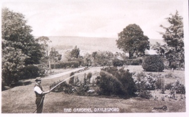
Photograph - Postcard, Wombat Hill Gardens, Daylesford
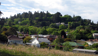
The Daylesford Botanic Gardens are of historic, scientific (botanic), and aesthetic significance to the State of Victoria. The Daylesford Botanic Gardens are historically significant as a fine example of a regional botanic garden demonstrating the typical characteristics of a carriage drive, informal park layout, decorative structures and works such as the memorial tower, conservatory, rotunda, cascade and fernery, which contrasts with the open lawns planted with specimen trees, areas of intensive horticultural interest and close proximity to a township developed during the mid to late nineteenth century. The Daylesford Botanic Gardens are historically significant for the design input by noted landscape designer William Sangster, and for the survival of his 1884 plan, which is a rare example of a plan from this prolific garden designer. The Daylesford Botanic Gardens are of scientific (botanic) significance for the extensive conifer collection and cool climate plants. The Gardens contain an outstanding collection of conifers and other mature trees, many of which were donated by renowned botanist Ferdinand von Mueller. Significant trees include Pinus ponderosa (Western Yellow Pine), Pinus coulteri (Big Cone Pine), twoAbies nordmanniana (Caucasian Fir), Abies pinsapo, (Spanish Fir) and a Cedrus atlantica f. glauca(Blue Atlas Cedar), Pinus wallichiana (Bhutan Pine), Pinus pinaster (Maritime Pine), Sequoiadendron giganteum (Giant Redwood), (Monkey Puzzle) and Aesculus hippocastanum (Horse Chestnut), many the largest or finest examples in Victoria. Other outstanding trees include a Tilia cordata (Small-leaved European Linden), a row of Cupressus lusitanica (Mexican cypress), a Quercus robur (English Oak) planted in 1863, avenues of Dutch Elms and a rare Quercus leucotrichophora (Himalayan Oak). The Daylesford Botanic Gardens are of aesthetic significance as a rare example of a botanic garden spectacularly sited on an extinct volcanic cone which allows a panoramic view, aided by the 1938 Pioneers’ Memorial Tower, as well as vistas within and out of the gardens and from the township to the gardens. As the most prominent local landmark, the Garden’s vertical dominance in the landscape provides a dark contrast to the elms avenues, oaks and other deciduous species. (Heritage Victoria Register, )Black and white postcard of Wombat Hill Botanical Gardens, Daylesford.wombat hill botanical gardens, daylesford, gardener, wombat hill botanic gardens -
 Ballarat Heritage Services
Photograph - Digital photographs, L.J. Gervasoni, Wombat Hill Botanic Gardens 150 anniversary event Daylesford community event, 2013
The Daylesford Botanic Gardens are of historic, scientific (botanic), and aesthetic significance to the State of Victoria. The Daylesford Botanic Gardens are historically significant as a fine example of a regional botanic garden demonstrating the typical characteristics of a carriage drive, informal park layout, decorative structures and works such as the memorial tower, conservatory, rotunda, cascade and fernery, which contrasts with the open lawns planted with specimen trees, areas of intensive horticultural interest and close proximity to a township developed during the mid to late nineteenth century. The Daylesford Botanic Gardens are historically significant for the design input by noted landscape designer William Sangster, and for the survival of his 1884 plan, which is a rare example of a plan from this prolific garden designer. The Daylesford Botanic Gardens are of scientific (botanic) significance for the extensive conifer collection and cool climate plants. The Gardens contain an outstanding collection of conifers and other mature trees, many of which were donated by renowned botanist Ferdinand von Mueller. Significant trees include Pinus ponderosa (Western Yellow Pine), Pinus coulteri (Big Cone Pine), twoAbies nordmanniana (Caucasian Fir), Abies pinsapo, (Spanish Fir) and a Cedrus atlantica f. glauca(Blue Atlas Cedar), Pinus wallichiana (Bhutan Pine), Pinus pinaster (Maritime Pine), Sequoiadendron giganteum (Giant Redwood), (Monkey Puzzle) and Aesculus hippocastanum (Horse Chestnut), many the largest or finest examples in Victoria. Other outstanding trees include a Tilia cordata (Small-leaved European Linden), a row of Cupressus lusitanica (Mexican cypress), a Quercus robur (English Oak) planted in 1863, avenues of Dutch Elms and a rare Quercus leucotrichophora (Himalayan Oak). The Daylesford Botanic Gardens are of aesthetic significance as a rare example of a botanic garden spectacularly sited on an extinct volcanic cone which allows a panoramic view, aided by the 1938 Pioneers’ Memorial Tower, as well as vistas within and out of the gardens and from the township to the gardens. As the most prominent local landmark, the Garden’s vertical dominance in the landscape provides a dark contrast to the elms avenues, oaks and other deciduous species. (Heritage Victoria Register, )Digital imagesvictoria, 150, anniversary, botanic, gardens, wombat hill, botanic gardens, heritage, celebration, garden party, daylesford, people, crowd, community, john hawker, john madigan, stilt, trees, owls, wombat hill botanic gardens -
 Ballarat Heritage Services
Photograph - digital photographs, Lisa Gervasoni, Wombat Hill, Daylesford, c2006-2016
The Daylesford Botanic Gardens are of historic, scientific (botanic), and aesthetic significance to the State of Victoria. The Daylesford Botanic Gardens are historically significant as a fine example of a regional botanic garden demonstrating the typical characteristics of a carriage drive, informal park layout, decorative structures and works such as the memorial tower, conservatory, rotunda, cascade and fernery, which contrasts with the open lawns planted with specimen trees, areas of intensive horticultural interest and close proximity to a township developed during the mid to late nineteenth century. The Daylesford Botanic Gardens are historically significant for the design input by noted landscape designer William Sangster, and for the survival of his 1884 plan, which is a rare example of a plan from this prolific garden designer. The Daylesford Botanic Gardens are of scientific (botanic) significance for the extensive conifer collection and cool climate plants. The Gardens contain an outstanding collection of conifers and other mature trees, many of which were donated by renowned botanist Ferdinand von Mueller. Significant trees include Pinus ponderosa (Western Yellow Pine), Pinus coulteri (Big Cone Pine), twoAbies nordmanniana (Caucasian Fir), Abies pinsapo, (Spanish Fir) and a Cedrus atlantica f. glauca(Blue Atlas Cedar), Pinus wallichiana (Bhutan Pine), Pinus pinaster (Maritime Pine), Sequoiadendron giganteum (Giant Redwood), (Monkey Puzzle) and Aesculus hippocastanum (Horse Chestnut), many the largest or finest examples in Victoria. Other outstanding trees include a Tilia cordata (Small-leaved European Linden), a row of Cupressus lusitanica (Mexican cypress), a Quercus robur (English Oak) planted in 1863, avenues of Dutch Elms and a rare Quercus leucotrichophora (Himalayan Oak). The Daylesford Botanic Gardens are of aesthetic significance as a rare example of a botanic garden spectacularly sited on an extinct volcanic cone which allows a panoramic view, aided by the 1938 Pioneers’ Memorial Tower, as well as vistas within and out of the gardens and from the township to the gardens. As the most prominent local landmark, the Garden’s vertical dominance in the landscape provides a dark contrast to the elms avenues, oaks and other deciduous species. (Heritage Victoria Register, )Colour photograph of Wombat Hill Botanical Gardens, Daylesford.heritage, daylesford, townscape, wombat hill, wombat hill botanical gardens, wombat hill botanic gardens -
 Ballarat Heritage Services
Photograph - Digital photographs, L.J. Gervasoni, Wombat Hill in the Fog, c2015
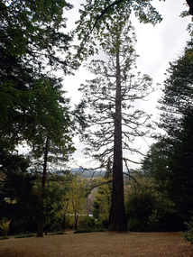
The Daylesford Botanic Gardens are of historic, scientific (botanic), and aesthetic significance to the State of Victoria. The Daylesford Botanic Gardens are historically significant as a fine example of a regional botanic garden demonstrating the typical characteristics of a carriage drive, informal park layout, decorative structures and works such as the memorial tower, conservatory, rotunda, cascade and fernery, which contrasts with the open lawns planted with specimen trees, areas of intensive horticultural interest and close proximity to a township developed during the mid to late nineteenth century. The Daylesford Botanic Gardens are historically significant for the design input by noted landscape designer William Sangster, and for the survival of his 1884 plan, which is a rare example of a plan from this prolific garden designer. The Daylesford Botanic Gardens are of scientific (botanic) significance for the extensive conifer collection and cool climate plants. The Gardens contain an outstanding collection of conifers and other mature trees, many of which were donated by renowned botanist Ferdinand von Mueller. Significant trees include Pinus ponderosa (Western Yellow Pine), Pinus coulteri (Big Cone Pine), twoAbies nordmanniana (Caucasian Fir), Abies pinsapo, (Spanish Fir) and a Cedrus atlantica f. glauca(Blue Atlas Cedar), Pinus wallichiana (Bhutan Pine), Pinus pinaster (Maritime Pine), Sequoiadendron giganteum (Giant Redwood), (Monkey Puzzle) and Aesculus hippocastanum (Horse Chestnut), many the largest or finest examples in Victoria. Other outstanding trees include a Tilia cordata (Small-leaved European Linden), a row of Cupressus lusitanica (Mexican cypress), a Quercus robur (English Oak) planted in 1863, avenues of Dutch Elms and a rare Quercus leucotrichophora (Himalayan Oak). The Daylesford Botanic Gardens are of aesthetic significance as a rare example of a botanic garden spectacularly sited on an extinct volcanic cone which allows a panoramic view, aided by the 1938 Pioneers’ Memorial Tower, as well as vistas within and out of the gardens and from the township to the gardens. As the most prominent local landmark, the Garden’s vertical dominance in the landscape provides a dark contrast to the elms avenues, oaks and other deciduous species. (Heritage Victoria Register, )Black and white photograph of a treed landscape covered with fog. The trees are in the Daylesford Botanical Gardens on Wombat Hill.wombat hill botanic gardens, wombat hill, daylesford, daylesford botanic gardens, fog, weather, arboretum -
 Ballarat Heritage Services
Photograph - Photograph - Colour, Clare Gervasoni, Wombat Botanic Gardens, Daylesford, 2019, 23/04/2019
The Daylesford Botanic Gardens are of historic, scientific (botanic), and aesthetic significance to the State of Victoria. The Daylesford Botanic Gardens are historically significant as a fine example of a regional botanic garden demonstrating the typical characteristics of a carriage drive, informal park layout, decorative structures and works such as the memorial tower, conservatory, rotunda, cascade and fernery, which contrasts with the open lawns planted with specimen trees, areas of intensive horticultural interest and close proximity to a township developed during the mid to late nineteenth century. The Daylesford Botanic Gardens are historically significant for the design input by noted landscape designer William Sangster, and for the survival of his 1884 plan, which is a rare example of a plan from this prolific garden designer. The Daylesford Botanic Gardens are of scientific (botanic) significance for the extensive conifer collection and cool climate plants. The Gardens contain an outstanding collection of conifers and other mature trees, many of which were donated by renowned botanist Ferdinand von Mueller. Significant trees include Pinus ponderosa (Western Yellow Pine), Pinus coulteri (Big Cone Pine), twoAbies nordmanniana (Caucasian Fir), Abies pinsapo, (Spanish Fir) and a Cedrus atlantica f. glauca(Blue Atlas Cedar), Pinus wallichiana (Bhutan Pine), Pinus pinaster (Maritime Pine), Sequoiadendron giganteum (Giant Redwood), (Monkey Puzzle) and Aesculus hippocastanum (Horse Chestnut), many the largest or finest examples in Victoria. Other outstanding trees include a Tilia cordata (Small-leaved European Linden), a row of Cupressus lusitanica (Mexican cypress), a Quercus robur (English Oak) planted in 1863, avenues of Dutch Elms and a rare Quercus leucotrichophora (Himalayan Oak). The Daylesford Botanic Gardens are of aesthetic significance as a rare example of a botanic garden spectacularly sited on an extinct volcanic cone which allows a panoramic view, aided by the 1938 Pioneers’ Memorial Tower, as well as vistas within and out of the gardens and from the township to the gardens. As the most prominent local landmark, the Garden’s vertical dominance in the landscape provides a dark contrast to the elms avenues, oaks and other deciduous species. (Heritage Victoria Register, )A tree in the Wombat Hill Gardens.wombat botanical gardens, daylesford botanical gardens, daylesford, trees, wombat hill botanic gardens -
 Ballarat Heritage Services
Photograph - Photograph - Colour, Clare Gervasoni, Wombat Botanic Gardens, Daylesford, 2019, 23/04/2019
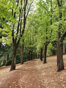
The Daylesford Botanic Gardens are of historic, scientific (botanic), and aesthetic significance to the State of Victoria. The Daylesford Botanic Gardens are historically significant as a fine example of a regional botanic garden demonstrating the typical characteristics of a carriage drive, informal park layout, decorative structures and works such as the memorial tower, conservatory, rotunda, cascade and fernery, which contrasts with the open lawns planted with specimen trees, areas of intensive horticultural interest and close proximity to a township developed during the mid to late nineteenth century. The Daylesford Botanic Gardens are historically significant for the design input by noted landscape designer William Sangster, and for the survival of his 1884 plan, which is a rare example of a plan from this prolific garden designer. The Daylesford Botanic Gardens are of scientific (botanic) significance for the extensive conifer collection and cool climate plants. The Gardens contain an outstanding collection of conifers and other mature trees, many of which were donated by renowned botanist Ferdinand von Mueller. Significant trees include Pinus ponderosa (Western Yellow Pine), Pinus coulteri (Big Cone Pine), twoAbies nordmanniana (Caucasian Fir), Abies pinsapo, (Spanish Fir) and a Cedrus atlantica f. glauca(Blue Atlas Cedar), Pinus wallichiana (Bhutan Pine), Pinus pinaster (Maritime Pine), Sequoiadendron giganteum (Giant Redwood), (Monkey Puzzle) and Aesculus hippocastanum (Horse Chestnut), many the largest or finest examples in Victoria. Other outstanding trees include a Tilia cordata (Small-leaved European Linden), a row of Cupressus lusitanica (Mexican cypress), a Quercus robur (English Oak) planted in 1863, avenues of Dutch Elms and a rare Quercus leucotrichophora (Himalayan Oak). The Daylesford Botanic Gardens are of aesthetic significance as a rare example of a botanic garden spectacularly sited on an extinct volcanic cone which allows a panoramic view, aided by the 1938 Pioneers’ Memorial Tower, as well as vistas within and out of the gardens and from the township to the gardens. As the most prominent local landmark, the Garden’s vertical dominance in the landscape provides a dark contrast to the elms avenues, oaks and other deciduous species. (Heritage Victoria Register, 2025)An avenue of trees in the Wombat Hill Gardens. wombat botanical gardens, daylesford botanical gardens, daylesford, trees -
 Ballarat Heritage Services
Photograph - Photograph - Colour, Clare Gervasoni, Wombat Botanic Gardens, Daylesford, 2019, 23/04/2019
The Daylesford Botanic Gardens are of historic, scientific (botanic), and aesthetic significance to the State of Victoria. The Daylesford Botanic Gardens are historically significant as a fine example of a regional botanic garden demonstrating the typical characteristics of a carriage drive, informal park layout, decorative structures and works such as the memorial tower, conservatory, rotunda, cascade and fernery, which contrasts with the open lawns planted with specimen trees, areas of intensive horticultural interest and close proximity to a township developed during the mid to late nineteenth century. The Daylesford Botanic Gardens are historically significant for the design input by noted landscape designer William Sangster, and for the survival of his 1884 plan, which is a rare example of a plan from this prolific garden designer. The Daylesford Botanic Gardens are of scientific (botanic) significance for the extensive conifer collection and cool climate plants. The Gardens contain an outstanding collection of conifers and other mature trees, many of which were donated by renowned botanist Ferdinand von Mueller. Significant trees include Pinus ponderosa (Western Yellow Pine), Pinus coulteri (Big Cone Pine), twoAbies nordmanniana (Caucasian Fir), Abies pinsapo, (Spanish Fir) and a Cedrus atlantica f. glauca(Blue Atlas Cedar), Pinus wallichiana (Bhutan Pine), Pinus pinaster (Maritime Pine), Sequoiadendron giganteum (Giant Redwood), (Monkey Puzzle) and Aesculus hippocastanum (Horse Chestnut), many the largest or finest examples in Victoria. Other outstanding trees include a Tilia cordata (Small-leaved European Linden), a row of Cupressus lusitanica (Mexican cypress), a Quercus robur (English Oak) planted in 1863, avenues of Dutch Elms and a rare Quercus leucotrichophora (Himalayan Oak). The Daylesford Botanic Gardens are of aesthetic significance as a rare example of a botanic garden spectacularly sited on an extinct volcanic cone which allows a panoramic view, aided by the 1938 Pioneers’ Memorial Tower, as well as vistas within and out of the gardens and from the township to the gardens. As the most prominent local landmark, the Garden’s vertical dominance in the landscape provides a dark contrast to the elms avenues, oaks and other deciduous species. (Heritage Victoria Register, 2025)A large tree in the Wombat Gardens. wombat botanical gardens, daylesford botanical gardens, daylesford, trees, lisa gervasoni, wombat botanic gardens -
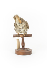 The Beechworth Burke Museum
Animal specimen - Bassian Thrush, Trustees of the Australian Museum, 1860-1880
The habitat of the Bassian Thrush includes leaf littered and canopied gullies and dense forests. It forages for food on the ground eating small invertebrates and nests in tree stumps and tree forks. Primarily found in Tasmania, South Australia and Queensland, there are three sub-species of thrush, Zoothera lunulata cuneate (Queensland), Zoothera lunulata halmaturina (South Australian and Western Bassian Thrushes) and Zoothera lunulata lunulata/Zoothera lunulata macrorhyncha (South East Australia, Queensland, Victoria and Tasmania). Because this bird is a ground foraging species, the main threat to the Bassian Thrush is the ground clearing of its habitat, and unfortunately, the South Australian Zoothera lunulata halmaturina sub-species is considered vulnerable because of the bush fires that have eliminated much of its habitat, especially on Kangaroo Island. While the overall structure of this particular representation of a Bassian Thrush is relatively accurate, some of the smaller details are lacking. The eyes within this particular specimen are not accurate. Instead of solid black eyes, this specimen has golden/yellow eyes with black pupils. Another inaccuracy is some inappropriate intrusions coming from the beak (most noticeable in the left and right close up images). From the photographs, it is unclear if this is a representative/presentation choice or a condition problem caused overtime. Unfortunately, several aging problems have also occurred over time, with the bird’s feathers fading (Bassian Thrushes have distinct dark brown and black and white scalloped plumage) and the beak which was probably once dark grey has faded to the under colour, a yellowy cream. This specimen is part of a collection of almost 200 animal specimens that were originally acquired as skins from various institutions across Australia, including the Australian Museum in Sydney and the National Museum of Victoria (known as Museums Victoria since 1983), as well as individuals such as amateur anthropologist Reynell Eveleigh Johns between 1860-1880. These skins were then mounted by members of the Burke Museum Committee and put-on display in the formal space of the Museum’s original exhibition hall where they continue to be on display. This display of taxidermy mounts initially served to instruct visitors to the Burke Museum of the natural world around them, today it serves as an insight into the collecting habits of the 19th century.This specimen is part of a significant and rare taxidermy mount collection in the Burke Museum. This collection is scientifically and culturally important for reminding us of how science continues to shape our understanding of the modern world. They demonstrate a capacity to hold evidence of how Australia’s fauna history existed in the past and are potentially important for future environmental research. This collection continues to be on display in the Museum and has become a key part to interpreting the collecting habits of the 19th century.The Bassian Thrush has white and black scalloped plumage on its underbelly with caramel, soft brown and black tipped scalloped plumage on its back. This soft brown continues onto the bird’s head and neck. The thrush has a white rim around the glass black eyes. When seen in flight, there is also a noticeable wide band across the underside of the wings which is not visible on this specimen due to its particular stance.Swing tag appears to read: ‘46a [the a is superscripted] / Mountain Thrush. / See Catalogue, Page 16. / The number in the top centre of the wooden perch reads '63'taxidermy mount, taxidermy, animalia, burke museum, beechworth, australian museum, skin, reynell eveleigh johns, bird, bassian thrush, zoothera lunulata, white's thrush, ground thrush, scaly thrush -
 Eltham District Historical Society Inc
Photograph, Fay Bridge, Clifton Pugh's Artists' Colony, Dunmoochin, Barreenong Road, Cottles Bridge, c.1995
Visit to Dunmoochin prior to Clifton Pugh's home being destroyed by fire in 2002. Following military service in the second world war, Clifton Pugh studied under artist Sir William Dargie at the National Gallery School in Melbourne as well as Justus Jorgensen, founder of Montsalvat. For a while he lived on the dole but also worked packing eggs for the Belot family saving sufficient to purchase six acres (2.4 ha) of land at Barreenong Road, Cottles Bridge. He accumulated more land and persuaded several other artists and friends to buy land nearby, resulting in a property of approximately 200 acres, stablishing it as one of the first artistic communes in Australia alongside Montsalvat in Eltham. It was around 1951 that Pugh felt he had '"done moochin' around" and so the name of the property evolved. He bought timber from Alistair Knox to build his house on the crest of a hill. Inspired by local goldminer's huts, it was a one room wattle-and-daub structure with dirt floor. Over the years it expanded with thick adobe walls made from local clay, high ceilings and stone floors. All materials other than the local earth were sourced from second hand materials, most found at wreckers' yards. Artists from across the nation were drawn to Dunmoochin, with several setting up houses and shacks on the property, maintaining their independence but sharing their artistic zeal. Artists who worked or resided at Dunmoochin included Mirka Mora, John Perceval, Albert Tucker, Fred Williams, Charles Blackman, Arthur Boyd and John Olsen. In 2002, Pugh's house along with its treasure trove of art and a library of some 20,000 books was destroyed by fire. Traces of Pugh's home remain with the presence of the Victorian doorframe archway with leadlight of intricate design, procured from a demolished Melbourne mansion; and two bronze life-sized female statues created by Pugh and cast by Matcham Skipper. In place of Pugh's house rose two double-storey mud-brick artists' studios topped with corrugated iron rooves curved like the wings of a bird with accommodation for seven. The original studios, gallery and other buildings survived the fire.fay bridge collection, 1995, barreenong road, cottles bridge, dunmoochin -
 Orbost & District Historical Society
black and white photograph, C 1922
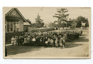
DESCRIPTIONA black / white photograph on a grey buff cardboard frame. It is of a group of students standing outside the Orbost State School building. One child holds a sign reading "Form F". There is a photographer's label at the bottom.SIZEH-199mm W-028mmOBJECT REGISTRATION890KEYWORDSeducation-orbost orbost-state-schoolHISTORICAL INFORMATIONThe 19th of March 1886 proved an important day in the lives of many early settlers in the Orbost area, because on this day the Orbost State School opened. The fact that the school had first operated temporarily in a leased building, and on a half-time basis with SS2745 Jarrahmond, did not dampen the enthusiasm of the local inhabitants as they saw their offspring commence their education under the guidance of HT Campbell Mackay. However he remained in charge only until 12th of May 1886. The second HT, John Rowe, served until 1908. On 30th of June 1887, a portable room was provided; it being brought to the area by schooner. The school now had accommodation for 30 pupils; the teacher's welfare was considered because quarters of two rooms were attached. As the population increased so did the needs of the school. This was reflected in the provision of a larger classroom in 1898. During 1910-11 the first approaches were made to the Department for the establishment of a HES in Orbost and this became a reality in 1912. Orbost HES supplied post-primary education in the district until a high school was built in 1948. When fire destroyed the school in 1941 local halls were used as classrooms until a new school was built. Work was quite rapid and a new brick structure was opened by the Hon. A. E. Lind, MLA, on 13th of February 1942. This new building was a fine type of school of which both the pupils and the HT Leslie Collins were indeed proud. But Orbost continued to develop and the new school was soon overtaxed. This resulted in the erection of two Bristol classrooms in 1947. By 1950, when the school population had reached 500 pupils the opening of the new school at Orbost North was welcomed by all concerned. In 1963 the Department purchased land diagonally opposite the school and developed it as a playing area. In 1965 two LTCs were opened in November, and in October 1968 the Brodribb School building was moved to SS2744 Orbost for use as a general purpose room. ( Info. from Schools East Gippsland)This item is associated with the history of education in Orbost.A black / white photograph of a large group of children standing outside a school building - " Orbost State School No. 2744". The younger students are standing in the front. High School students are at the back.on back - "Mr C. Connor S.M. Mr Tipper H.M. State & H.E.s. about 1922"education-orbost orbost-state-school orbost-higher-elementary-school -
 Orbost & District Historical Society
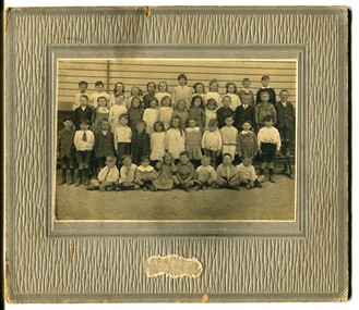
black and white photograph, C 1920
Phyllis May Waller was born Orbost in 1912. Her father-was Frank Hale Waller and her mother -Sarah Elizabeth Clancy. Phyllis married Clive Howell Crawford Pasco in 1934 (Clive was born 1908 at Prahran, and died in 1971 at South Melbourne). "The 19th of March 1886 proved an important day in the lives of many early settlers in the Orbost area, because on this day the Orbost State School opened. The fact that the school had first operated temporarily in a leased building, and on a half-time basis with SS2745 Jarrahmond, did not dampen the enthusiasm of the local inhabitants as they saw their offspring commence their education under the guidance of HT Campbell Mackay. However he remained in charge only until 12th of May 1886. The second HT, John Rowe, served until 1908. On 30th of June 1887, a portable room was provided; it being brought to the area by schooner. The school now had accommodation for 30 pupils; the teacher's welfare was considered because quarters of two rooms were attached. As the population increased so did the needs of the school. This was reflected in the provision of a larger classroom in 1898. During 1910-11 the first approaches were made to the Department for the establishment of a HES in Orbost and this became a reality in 1912. Orbost HES supplied post-primary education in the district until a high school was built in 1948. When fire destroyed the school in 1941 local halls were used as classrooms until a new school was built. Work was quite rapid and a new brick structure was opened by the Hon. A. E. Lind, MLA, on 13th of February 1942. This new building was a fine type of school of which both the pupils and the HT Leslie Collins were indeed proud. But Orbost continued to develop and the new school was soon overtaxed. This resulted in the erection of two Bristol classrooms in 1947. By 1950, when the school population had reached 500 pupils the opening of the new school at Orbost North was welcomed by all concerned. In 1963 the Department purchased land diagonally opposite the school and developed it as a playing area. In 1965 two LTCs were opened in November, and in October 1968 the Brodribb School building was moved to SS2744 Orbost for use as a general purpose room."This item is associated with the history of education in Orbost. It is also associated with the Waller family, early settlers in Orbost.A black / white photograph on grey card. Against a wooden building are four rows of young children. The front row of the youngest children is sitting with crossed legs.The back three rows are tiered. the children appear to be dressed in their best clothes with many of the boys wearing ties. There is a photographer's label at the bottom.on back written by older son -"Orbost State School Approx. 1920 Mum (Phyllis May Waller) 6th from left 2nd back row"waller-phyllis-may -
 National Wool Museum
Painting, The White Farm, 2020/21
The farm buildings that Linda Gallus has studied and painted are on the farmland adjoining the Leura Park properties in Curlewis, on the Bellarine Peninsula. The current owner of the property told Linda that he bought the farm in 1994. He has used it for both sheep and cattle grazing since purchasing the property. When the farmer bought the land all the buildings on the property were painted white for sale, despite the fact they were very old. The shearing shed was in use up until the time of sale but was in a bad state of disrepair. The roof, stumps and floor required replacing. The building was no longer in use after the sale, so the shearing shed gradually fell into further disrepair. The previous owner had also used the property for growing potatoes, crops and livestock, mainly sheep. Linda’s fascination with the property came when she caught a glimpse of the white chimney over the hill driving towards Point Lonsdale, which still stands proud today on the roof of the old shearing shed. The owner kindly allowed her to visit the property over the past few years to capture the buildings using photography and painting. During this time many of the buildings have fallen. Linda calls it The White Farm as there are remnants of that original white paint on the outside of most of the buildings giving it a strange and rather beautiful patina. The structures are wonderful remnants of the history of the Bellarine. Linda first spotted the old shearing shed when she was driving home to Clifton Springs from Geelong. It was the white chimney on the shearing shed that stood out behind the rolling grassy hills. It was intriguing – bright white and still in good condition, unlike the rest of the building. After further investigation Linda got to know the owner of the property and visited it frequently to draw, take photos and paint. There is a variety of lovely old buildings on the property, but it was the shearing shed that held extra fascination for Linda. The most intriguing thing for Linda was that the buildings were all painted white at some stage and now the patina of peeling paint and bleached timber brought a wonderful mood and feeling to the farm. This is what she has tried to capture in this series of 11 paintings. Most of the buildings are falling, so Linda felt an urgency to capture them using acrylic paint on canvas in order to commemorate them forever.Acrylic Paint on Canvas. The images both feature a falling down shearing shed as the central focus. The wood of the shearing shed is a central theme of importance. The old buildings were painted white for sale despite being in a state of structural instability. After time this same painted wood has been left with an interesting complex patina like film on the surface which the artist has taken great care to capture. Image 1 is titled ‘Another gust of Wind’. It shows the exterior of the shearing shed which is in the process of collapsing from the forces of mother nature. In the background of this painting another of the buildings in the ‘White Farm’ complex is visible, in addition to blue skies and overgrown green grasses. Image 2 is titled ‘Green Trough’. It features the interior of the same collapsing shearing shed. The image is painted as though the viewer is peering through a crack of the external wall. Internally a green trough is seen hanging on an internal fence. Unlike everything else in the shearing shed, the trough appears new and in good condition. It provides a strong juxtaposition to the rest of the shearing shed, and the larger surrounding ‘White Farm’ complexbellarine peninsula, the white farm, shearing shed -
 Kew Historical Society Inc
Album - Photographs of heritage sites in Victoria, Eva Grant, 1964-66
Eva Grant was a member of the Kew Historical Society. Three albums in the collection were created by her, this one, the third created between 1964 and 1966. They were donated to the Society by her daughter in 2010. Each of the albums includes photographs and newspaper cuttings collected on her travels to historic places in South East Australia in the 1950s and 1960s. Particular structures photographed in this album include: Barnawatha (Vic.) - The Hermitage | Beveridge (Vic.) - Stone cottage where Ned Kelly was born. | Brighton - St Andrew’s Church graveyard. | Chiltern (Vic.) - lake view [missing] | Cowes (Vic.) - ‘Broadwater’ [originally home of Henty-Wilson family], demolished 1965; Bell of the Speke wreck; Edward’s tree. | Euroa (Vic.) - Habbies Howe | Fairfield (Vic.) - Dight’s Falls; John Dight. | Fernshawe (Vic.) - Queen Mary tree. | Jolimont (Vic.) - Old railway tunnel linking the first Government House (1964); Sign identifying location of first Government House. | Kew (Vic.) - Cairn at Dight’s Falls; Canoe tree, Bowyer Avenue. | Kyneton - De Grave’s Flour Mill - “C”. | Maldon (Vic.) - Chinese oven; Macarthur’s House; Maldon’s oldest resident; Chinese graves x 2; [Beehive Chimney]. | Marysville (Vic.) - Centenary cairn | Mitcham (Vic.), Mud brick house x 2, Deep Creek Road. | Melbourne (Vic.) - St Paul’s Cathedral [renovation] (1964); Wreckers at Damman’s Corner, cnr Bourke and Collins Streets (1964); Princess Gate project x 2 (1964); Colonial Storekeeper’s building on cnr King and Bourke Streets (1966); Early observatory 1861-3; the Honey Memorial. | Mt Oberon (Vic.) - [obsolete] radio telephone dish. | Seymour (Vic.) - Habres (sic) House x 3.| Swan Hill (Vic.) - Major Mitchell’s Cairn (12/1964); Headstone of Andrew Beverage AM (12/1964). | Templestowe (Vic.) - Finn’s Hotel. | Thornton (Vic.) - Eildon Station. | Werribee (Vic.) - Chirnside Memorial [Presbyterian] Church; gaslight beside church | Location unknown, but possibly Swan Hill - Brick house; Wooden bullock dray. | Location unknown - Headstone of John Furlonge 1835.Important record of significant heritage properties in Victoria, many of which have since been demolished.30 page spirex bound drawing book including photographs and newspaper articles of historic buildings in Victoria. The front cover has a picture of a steam boat. The cover is encased in plastic. A number items in the album are annotated with written commentary by Eva Grant who compiled the album. Annotations and transcriptions by Eva Grant on most imageseva grant, photograph albums, heritage places - victoria -
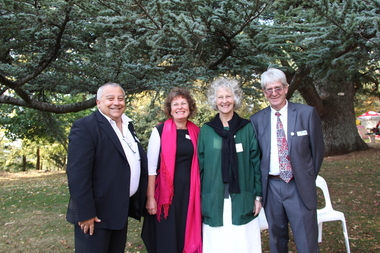 Ballarat Heritage Services
Photograph - Digital photographs, L.J. Gervasoni, Wombat Hill Botanic Gardens 150 anniversary event Daylesford organiser Gael Shannon, 2013
The Wombat Hill Botanic Gardens 150 anniversary event organiser was Gael Shannon. The Daylesford Botanic Gardens are of historic, scientific (botanic), and aesthetic significance to the State of Victoria. The Daylesford Botanic Gardens are historically significant as a fine example of a regional botanic garden demonstrating the typical characteristics of a carriage drive, informal park layout, decorative structures and works such as the memorial tower, conservatory, rotunda, cascade and fernery, which contrasts with the open lawns planted with specimen trees, areas of intensive horticultural interest and close proximity to a township developed during the mid to late nineteenth century. The Daylesford Botanic Gardens are historically significant for the design input by noted landscape designer William Sangster, and for the survival of his 1884 plan, which is a rare example of a plan from this prolific garden designer. The Daylesford Botanic Gardens are of scientific (botanic) significance for the extensive conifer collection and cool climate plants. The Gardens contain an outstanding collection of conifers and other mature trees, many of which were donated by renowned botanist Ferdinand von Mueller. Significant trees include Pinus ponderosa (Western Yellow Pine), Pinus coulteri (Big Cone Pine), twoAbies nordmanniana (Caucasian Fir), Abies pinsapo, (Spanish Fir) and a Cedrus atlantica f. glauca(Blue Atlas Cedar), Pinus wallichiana (Bhutan Pine), Pinus pinaster (Maritime Pine), Sequoiadendron giganteum (Giant Redwood), (Monkey Puzzle) and Aesculus hippocastanum (Horse Chestnut), many the largest or finest examples in Victoria. Other outstanding trees include a Tilia cordata (Small-leaved European Linden), a row of Cupressus lusitanica (Mexican cypress), a Quercus robur (English Oak) planted in 1863, avenues of Dutch Elms and a rare Quercus leucotrichophora (Himalayan Oak). The Daylesford Botanic Gardens are of aesthetic significance as a rare example of a botanic garden spectacularly sited on an extinct volcanic cone which allows a panoramic view, aided by the 1938 Pioneers’ Memorial Tower, as well as vistas within and out of the gardens and from the township to the gardens. As the most prominent local landmark, the Garden’s vertical dominance in the landscape provides a dark contrast to the elms avenues, oaks and other deciduous species. (Heritage Victoria Register, )Four people photographed at the 150th anniversary event at the Wombat Botanic Gardens.victoria, 150, anniversary, botanic, gardens, wombat hill, botanic gardens, heritage, celebration, garden party, daylesford, people, crowd, community, organiser, tour, gael shannon, don henderson, wombat hill botanic gardens -
 The Beechworth Burke Museum
Geological specimen - Feldspathic Sandstone
Feldspathic arenites are sandstones that contain less than 90% quartz, and more feldspar than unstable lithic fragments, and minor accessory minerals.Feldspathic sandstones are commonly immature or sub-mature.These sandstones occur in association with cratonic or stable shelf settings. Feldspathic sandstones are derived from granitic-type, primary crystalline, rocks. If the sandstone is dominantly plagioclase, then it is igneous in origin Sandstone features prominently in public buildings throughout Victoria. Most of the sandstone used as dimension stone in the State came from three sources: the Heatherlie quarry in the Grampians (Silurian), the Bacchus Marsh area (Permian), and the Barrabool Hills near Geelong (Cretaceous).Sandstone features prominently in public buildings throughout Victoria, making this specimen special as it shows the materials used by Victorian building companies. Sandstone can also be crushed, crushed stone is used in the construction of roadways and road structures such as bridges, and in buildings, both commercial and residential. This specimen is part of a larger collection of geological and mineral specimens collected from around Australia (and some parts of the world) and donated to the Burke Museum between 1868-1880. A large percentage of these specimens were collected in Victoria as part of the Geological Survey of Victoria that begun in 1852 (in response to the Gold Rush) to study and map the geology of Victoria. Collecting geological specimens was an important part of mapping and understanding the scientific makeup of the earth. Many of these specimens were sent to research and collecting organisations across Australia, including the Burke Museum, to educate and encourage further study. A feldspar-rich sandstone, a sandstone intermediate in composition between an arkosic sandstone and a quartz sandstone, containing 10% to 25% feldspar and less than 20% matrix material of clay, sericite, and chlorite. Feldspathic arenite containing less than 90 percent of the composition of quartz. Feldspar is the main composition. Feldspathic arenite may contain fragments of unstable rock, and a little amount of other minerals such as mica and heavy minerals. Some feldspathic arenite have pink or red color because of the presence of potassium feldspar or iron oxide. There are also colored light gray to white. These sandstones are usually medium to coarse grained and can contain a high percentage of granules with angular until subangular roundness. The content of the matrix can appear as the rest up to more than 15 percent, and sorting of grains can present as moderate to poorly sorted. Feldspathic sandstones are generally immature in textural maturity. Feldspathic arenite can not be judged from the structure of the sediment. Bedding can emerge from the laminate parallel to the crossbed. Fossils may appear in the layer deposited on the sea. Feldspathic arenites usually appear on the craton or the continental shelf, which can be associated with conglomerate, quartz lithic arenite, carbonate rock, or evaporites. This sandstone may also appear on the succession of sedimentary basins deposited on an unstable or deep sea, and moving arc setting. According to Pettijohn (1963) Arkose make up about 15 percent of all sandstones. Some Arkose formed in situ when the granite and related rocks disintegrate and generate granular sediments. Most of the material feldspathic sandstones derived from primary crystalline granitic rocks, such as granite or metasomatic rocks containing abundant potassium feldspar. Mineral contained in sandstones is mostly a form of plagioclase feldspar derived from quartz diorite or volcanic rock. Feldspar contained on this sandstone comes from arid to cool climates when the chemical weathering process is reduced.sandstone, natural stone, feldspathic sandstone, burke museum, geology, geological, geological specimen -
 Bendigo Military Museum
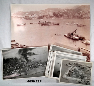
Photograph - PHOTOGRAPHS, KOREA, 1950-1953
The photos are a collection held by T. J. IRELAND C/K853677 P.O. STOKER MECHANIC RN while serving on HMS TRIUMPH, Korea 1950-53. Many are of the landings at INCHON, Sept. 1950. .1) Kure Harbour, Japan 1950. Ships assembling for the landings at INCHON, Korea. Ships across the top, left to right: HMAS SYDNEY, Fleet Oiler, VSS ANTIETAM, Hospital Ship & Japanese Coaster. In the foreground on the right, HMS BELFAST, HMS TRIUMPH, HMS CONSORT. On rear most photos are written on in blue pen. .2) INCHON landings Walmi-Do in background and landing barges - could be one I was driving. .3) Island - Walmi-Do - US landing craft. .4) INCHON landings. .5) US landing craft. .6) INCHON oil tanks and military targets on fire. .7) Grounded coaster after an air attack. .8) Two North Korean supply ships hit by rockets. .9) Korean supply vessels camouflaged. .10) Rocket attack on Korean supply vessel. .11) Sunken coaster that was carrying arms and food. .12) Sunken coaster in harbour. .13) & .14) North Korean armour taken from an observation flight. .15) & .16) Chinese tanks and armour. .17) HMS BELFAST, Fleet Oiler, HMAS WARRAMUNGA .18) Targets from rocket attacks. .19), .20) & .21) "Seafires" coming to land on HMS TRIUMPH. .22) Rearming cannon and rockets on a "Seafire'. Photos not written on, information was supplied by T.J. IRELAND. The "Seafire" was a naval adaption of the Supermarine Spitfire for carrier use..1) Photo, sepia tone, aerial view over a harbour with warships, bomb damage foreground, hills and buildings in the distance. .2) Photo, black & white, aerial view of harbour, city with several fires from shelling. .3) Photo, black & white, aerial view of island with landing craft. .4) Photo, black & white, aerial view over ships and harbour. .5) Photo, black & white, aerial view over four landing craft. .6) Photo, black & white, aerial view over city and fires. .7) Photo, black & white, aerial view over islands, boat .... small island. .8) Photo, black & white, aerial view over harbour with two boats on fire. .9) Photo, black & white, aerial view over structures covered. .10) Photo, black & white, aerial view over ship being attacked. .11) Photo, black & white, aerial view over harbour with sunken ship. .12) Photo, black & white, aerial view showing harbour, fire and sunken ship. .13) Photo, black & white, aerial view, five tanks along a road. .14) Photo, black & white, aerial view, same area as .13) showing a wider area. .15) Photo, black & white, aerial view showing tanks and armour. .16) Photo, black & white, aerial view road with armour, vehicles, people and smoke in distance. .17) Photo, black & white, aerial view showing three ships together. .18) Photo, black & white, aerial view showing a road control with targets either side on fire. .19) Photo, black & white, aerial view with aeroplane coming onto the deck of a carrier. .20) Photo, black & white, aerial view of a fighter plane. .21) Photo, black & white, on deck of a carrier. .22) Photo, black & white, rearming a plane with ammunition on carrier deck. Photos are various sizes.photos, korea, rn, inchon -
 Bendigo Historical Society Inc.
Document - CORNISH COLLECTION: DOCUMENTS RELATED TO VARIOUS CORNISH ENTERPRISES IN BENDIGO
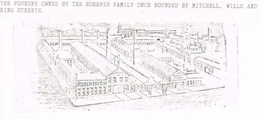
Documents and copies of photos related to various Cornish enterprises in Bendigo: a. Line drawing (faint) of foundry owned by the Roberts family (Mitchell, Wills and King streets); b. copy of article from unknown source re United Iron Works with details of the firm and Roberts principals - William Roberts, Abraham Roberts and Arthur Roberts - with copies of photographic portraits (Bartlett Bros.) - bad copy with LH side of text partly illegible; c. copy of article titled 'Goyne's Battery Gratings re John Goyne and history of the business (submitted by person living at ''Rosemundy'', Goynes Road, Epsom - Goyne's home then on 20 acres); d. Photograph of old Robinson photo of Bendigo Stamper Grating Factory, Epsom and five men posed in front of large timber building (badly cut photo with LH edge missing. original photo (9 x 13) of ''Former Bendigo Cornish Fuse Factory'' (handwritten inscription on reverse) taken in recent times (hint - car in driveway); f. copy from un-named book of J Nankervis's Ham and Bacon Curing Factory, Golden Square - drawing of the establishment and a photos of winning display of small goods at the Bendigo Show (no date); g. copy from un-named book of photo of premises of A J Williams, Lily and McKenzie Streets - wooden structure with sign indicating Hardware Merchants and ??Mines Furnisher?? , showing three horse-driven small wagons (delivery?); h. copy of photo of Cornish store(1880s) at White Hills - mention of Frederick Stuckenschmidt (married Miss Mary Smith), William Mathews (original owner?) - corner brick building with family posed outside alongside horse and light cart;. reproduction of exhibit in Bendigo Spring Show, 1915 , the ''Made in Bendigo Exhibition'' - first prize awarded to Messrs H M Legg & Co. Progress Jams, preserves, tomato sauce, tomatoes products, candied peels etc. (folded and small tear).bendigo, buildings, early bendigo businesses, bendigo stamper grating factory. epsom. j. nankervic ham and bacon curing establishment. golden square. bendigo cornish fuse factory. cornish stores. messrs h. m. leggo and co. abraham roberts. arthur roberts. william roberts. goyne's battery gratings. -
 Bendigo Historical Society Inc.
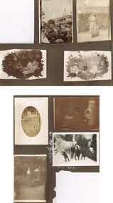
Photograph - HILDA HILL COLLECTION: BLACK AND WHITE PHOTOS, 1918-1923
Series of Black & White Photos of Hill Family and Friends during the war and post war life. Total 8 Photos. Welcome Parade General Pa n Bendigo October 21, 1918, tram wiring post in street, large two storey building in the background named Stanley's Coffee palace at corner of Mitchell and Mollison streets, Large crowd on roadway, Covered wagon among crowd with Good Shepherd laundry written on the side, foreground shows General Pau being driven through the crowd, General Pan is wearing a Napoleon style hat. Doreen dressed in a light coloured dress with white collar standing before a hedge, at rear is part of a corrugated iron roof gable, S.H.L.C. 27 September 1918. Group of four ladies three dressed in white and other a darker colour all seated on the ground, distant background a row of trees along a fence line, tea time Hibernian picnic Axedale 13 November 1918. Three women and young boy all seated on the ground, the ladies are all in white and two wearing white hats, young boy is dressed in suit with white shirt and dark tie and his right hand is pointing to his open mouth, to their right is a wooden structure and distant background more people can be seen, dinner time Hibernian picnic Axedale 13 November 1918. Overdeveloped photo of two young men standing between two shrubs and in front of a full length external window blind, 'The Ranche' February 1918. Group of four males dressed in dark coats and grey trouser at the snow Mt. Buffalo July 1923. Baby Irene clothed in white with bonnet seated in an English style pram with large wheels, picket fence and shrubbery in background, may 1918. Gert dressed in white shirt dark cardigan and dark skirt standing in front of hedged garden and trees, a small part of a roof can be seen between the trees, Railway Reserve 1918.Hilda Hill Personal Collectionaustralia, history, post war life -
 Melbourne Tram Museum
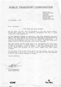
Administrative record - Correspondence, Public Transport Corporation (PTC), "A New Deal for Tram Drivers", 1989 - 1990
Set of 10 documents about the industrial action of early 1990, that resulted in the tram blockade. .1 - Letter from K. Fitzmaurice dated 30-11-1989 - titled "A New Deal for Tram Drivers", one page, regarding the phasing out of the tram conductors and increase in wages. .2 - ditto, dated 2/1/1990, two pages regarding the unauthorised use of a Met vehicle - occurred the previous day. .3 - Letter from Jim Kennan (Minister for Transport) and Neil Pope (Minister for Labour) - dated 4/1/1990, on Victoria Transport Letterhead, giving a guarantee to conductors. .4 - Letter from K. Fitzmaurice dated 9-1-1990 - one page regarding their future jobs and the impacts of Met Ticket and improved rates of pay. .5 - Advert in The Age, Full page 11/1/1990 - to all tram and bus crews - regarding Job Guarantee. .6 - Letter from K. Fitzmaurice dated 17-1-1990 - seven pages regarding - headed Government return to work proposal. Gives the proposals placed before the unions about Conductors and Met Tickets. .7 - Instruction to crews at Camberwell Depot dated 26/1/1990, 5 sheets stapled in top left hand corner, about the pending introduction of one person trams and the relevant instructions. Headed "Notice to One-person tram operations" .8 - Letter from K. Fitzmaurice dated 1/2/1990 - one page - "Return to Work Proposal" on PTC letterhead giving a summary of the agreement with the union. .9 - Letter from Ian Stoney Chief Executive of the PTC dated 29/5/1990 address to Carolyn Dean, regarding a review of one-person operation. .10 - One sheet - titled "pay structure - tram and bus" - gives the existing and proposed rates - not dated. May not be a 1990 document.trams, tramways, strike, ptc, met tram, tram blockade, unions, employees, conductors, drivers, one man trams, wages -
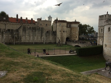 Ballarat Heritage Services
Digital photograph, Dorothy Wickham, Tower of London, 2016
The Tower of London, officially Her Majesty's Royal Palace and Fortress of the Tower of London, is a historic castle located on the north bank of the River Thames in central London. It lies within the London Borough of Tower Hamlets, separated from the eastern edge of the square mile of the City of London by the open space known as Tower Hill. It was founded towards the end of 1066 as part of the Norman Conquest of England. The White Tower, which gives the entire castle its name, was built by William the Conqueror in 1078, and was a resented symbol of oppression, inflicted upon London by the new ruling elite. The castle was used as a prison from 1100 (Ranulf Flambard) until 1952 (Kray twins),[3] although that was not its primary purpose. A grand palace early in its history, it served as a royal residence. As a whole, the Tower is a complex of several buildings set within two concentric rings of defensive walls and a moat. There were several phases of expansion, mainly under Kings Richard the Lionheart, Henry III, and Edward I in the 12th and 13th centuries. The general layout established by the late 13th century remains despite later activity on the site. The Tower of London has played a prominent role in English history. It was besieged several times, and controlling it has been important to controlling the country. The Tower has served variously as an armoury, a treasury, a menagerie, the home of the Royal Mint, a public record office, and the home of the Crown Jewels of England. From the early 14th century until the reign of Charles II, a procession would be led from the Tower to Westminster Abbey on the coronation of a monarch. In the absence of the monarch, the Constable of the Tower is in charge of the castle. This was a powerful and trusted position in the medieval period. In the late 15th century the castle was the prison of the Princes in the Tower. Under the Tudors, the Tower became used less as a royal residence, and despite attempts to refortify and repair the castle its defences lagged behind developments to deal with artillery. The peak period of the castle's use as a prison was the 16th and 17th centuries, when many figures who had fallen into disgrace, such as Elizabeth I before she became queen, Sir Walter Raleigh, and Elizabeth Throckmorton were held within its walls. This use has led to the phrase "sent to the Tower". Despite its enduring reputation as a place of torture and death, popularised by 16th-century religious propagandists and 19th-century writers, only seven people were executed within the Tower before the World Wars of the 20th century. Executions were more commonly held on the notorious Tower Hill to the north of the castle, with 112 occurring there over a 400-year period. In the latter half of the 19th century, institutions such as the Royal Mint moved out of the castle to other locations, leaving many buildings empty. Anthony Salvin and John Taylor took the opportunity to restore the Tower to what was felt to be its medieval appearance, clearing out many of the vacant post-medieval structures. In the First and Second World Wars, the Tower was again used as a prison, and witnessed the executions of 12 men for espionage. After the Second World War, damage caused during the Blitz was repaired, and the castle reopened to the public. Today the Tower of London is one of the country's most popular tourist attractions. Under the ceremonial charge of the Constable of the Tower, it is cared for by the charity Historic Royal Palaces and is protected as a World Heritage Site.(Wikipedia) A World Heritage Site is a landmark which has been officially recognized by the United Nations, specifically by UNESCO. Sites are selected on the basis of having cultural, historical, scientific or some other form of significance, and they are legally protected by international treaties. UNESCO regards these sites as being important to the collective interests of humanity. More specifically, a World Heritage Site is an already classified landmark on the earth, which by way of being unique in some respect as a geographically and historically identifiable piece is of special cultural or physical significance (such as either due to hosting an ancient ruins or some historical structure, building, city, complex, desert, forest, island, lake, monument, or mountain) and symbolizes a remarkable footprint of extreme human endeavour often coupled with some act of indisputable accomplishment of humanity which then serves as a surviving evidence of its intellectual existence on the planet. And with an ignoble intent of its practical conservation for posterity, but which otherwise could be subject to inherent risk of endangerment from human or animal trespassing, owing to unmonitored/uncontrolled/unrestricted nature of access or threat by natural or accelerated extinction owing to local administrative negligence, hence it would have been listed and demarcated by the United Nations Educational, Scientific and Cultural Organization (UNESCO) to have been identified or recognised and officially christened and internationally elevated through multilateral declaration by UNESCO as a universally protected zone. [1] The list is maintained by the international World Heritage Programme administered by the UNESCO World Heritage Committee, composed of 21 UNESCO member states which are elected by the General Assembly. (Wikipedia)The Tower of London is a UNESCO world heritage site.tower of london -
 Glen Eira Historical Society
Album - Album page, Kambrook Road, Circa 1972
This photograph is part of the Caulfield Historical Album 1972. This album was created in approximately 1972 as part of a project by the Caulfield Historical Society to assist in identifying buildings worthy of preservation. The album is related to a Survey the Caulfield Historical Society developed in collaboration with the National Trust of Australia (Victoria) and Caulfield City Council to identify historic buildings within the City of Caulfield that warranted the protection of a National Trust Classification. Principal photographer thought to be Trevor Hart, member of Caulfield Historical Society. Most photographs were taken between 1966-1972 with a small number of photographs being older and from unknown sources. All photographs are black and white except where stated, with 386 photographs over 198 pages. https://vhd.heritagecouncil.vic.gov.au/places/43737 - re 26 Kambrook Road and 345 Balaclava Road corner building: A prominently situated two-storeyed complex of late Victorian buildings consisting of "Wybar's Buildings" occupying the Balaclava Road/ Kambrook Road corner and the "Caulfield Bakery" facing Kambrook Road, separated by a driveway from a single storeyed shop. The main building has a comer splay and balustraded parapet with curved pediments, the words "Wybar's Buildings 1887" having been obliterated but "Caulfield Bakery 1887" with the characteristic wheatsheaf surviving in raised cement work. The walls are stuccoed and richly ornamented with bracketed cornices and keystones with masks extending to the Bakery. The main building is further distinguished by the Masonic symbol of the mason's dividers in the pediment whilst the upper level of the bakery is in overpainted brickwork. The single storeyed shop incorporates the bracketed cornice and consoles characteristic of the main buildings and is in other respects a utilitarian structure. https://vhd.heritagecouncil.vic.gov.au/places/35413 - re 16 Kambrook Road A small late Victorian Italianate villa distinguished by its parapeted window bays either side of a small verandah with encaustic tiled floor. The parapets are balustraded with console enrichment and glazed tiles, the stuccoed surfaces being unpainted. Ornamentation is in other respects undistinguished. https://www.gleneira.vic.gov.au/services/planning-and-building/heritage/heritage-management-plan - re 9-11 Kambrook Road ... they demonstrate most of the commonly employed aesthetic devices characteristic of the Italianate Style including patterned brickwork, patterned slate roofs, cast iron lace verandahs, ornamental stucco work and ashlar boards...https://vhd.heritagecouncil.vic.gov.au/places/43737 - 345 Balaclava and 26 Kambrook Roads HO91 in City of Glen Eira "Wybar's Buildings" at the corner of Balaclava Road and Kambrook Road are important as a prominent late Victorian commercial development incorporating a variety of activities including a bakery and possibly a coffee palace, the latter understood to be unique within the municipality, but characteristic of the period. It is a rare complex of its type in Caulfield and is important also as evocative evidence of the late Victorian Land Boom and the creation of a small now defunct commercial centre at this location by the George Wybrow. https://vhd.heritagecouncil.vic.gov.au/places/35413 - 16 Kambrook Road HO121 in City of Glen Eira ''Hollywood'' at 16 Kambrook Road is of architectural interest for its pavilions which retain their unpainted parapets and ornamental tiles in the manner of other less imposing examples in the immediate locality possibly linked with the builder George Wybar and his son, who undertook substantial projects nearby. Its association with James Yorston, presumably is Yorston of Dickson and Yorston, important builders and estate developers at Caulfield during the Inter war period is of interest. https://www.gleneira.vic.gov.au/services/planning-and-building/heritage/heritage-management-plan - re 9-11 Kambrook Road HO152 Normanby Road/Kambrook Road, Caulfield North Statement of Significance: The Precinct is historically significant for its capacity to demonstrate standards of design and building construction in this part of the municipality during the late Land Boom years and especially just prior to the bank collapse of 1891. The housing stock is representative of the standards of amenity excepted by the middle classes of Melbourne society at the time, including artists, (horse) trainers, jockeys, managers, travellers, journalists and the like, also having a functional link with the activities of the Caulfield Racecourse which forms an important element in the history of the Municipality. The row of attached pairs at 5-11 Kambrook Road and 53-67 Kambrook Road is especially significant in this respect in that the narrow allotments are indicative of the owner/developer’s determination to maximise profits at the height of the Land Boom in 1891...Page 104 of Photograph Album with four photographs (landscape) of three different properties on Kambrook Road.Handwritten: Kambrook Road [top right] / WYBAR'S BUILDING 1887/ INC CAULFIELD BAKERY / [under top right photo] / 16 KAMBROOK ROAD / 1970 HIRST MRS J.N.[under bottom left photo] / 11-9 KAMBROOK ROAD / 1970 9-BUCKLAND MRS L.A / 11- ATKINS MRS N.E. [under bottom right photo] / 104 [bottom right]trevor hart, kambrook road, victorian, caulfield north, parapets, wybar's buildings 1887, caulfield bakery 1887, architectural features, painted bricks, balaclava road, victorian italianate style, houses, bay windows, verandahs, glazed tiles, shops, george wybar, builders, james yorston, dickson and yorston, j n hirst, l a buckland, n e atkins, patterned slate roofs, patterned bricks, cast iron work, attached houses -
 Glen Eira Historical Society
Album - Album page, Kambrook Road, Circa 1972
This page of photographs is part of the Caulfield Historical Album 1972. This album was created in approximately 1972 as part of a project by the Caulfield Historical Society to assist in identifying buildings worthy of preservation. The album is related to a Survey the Caulfield Historical Society developed in collaboration with the National Trust of Australia (Victoria) and Caulfield City Council to identify historic buildings within the City of Caulfield that warranted the protection of a National Trust Classification. Principal photographer thought to be Trevor Hart, member of Caulfield Historical Society. Most photographs were taken between 1966-1972 with a small number of photographs being older and from unknown sources. All photographs are black and white except where stated, with 386 photographs over 198 pages. First 2 images: milkbar and residence corner Kambrook and Balaclava Roads ie south west corner - building named Airdrie 3rd image: https://vhd.heritagecouncil.vic.gov.au/places/43737 - re 26 Kambrook Road and 345 Balaclava Road corner building ie south east corner: A prominently situated two-storeyed complex of late Victorian buildings consisting of "Wybar's Buildings" occupying the Balaclava Road/ Kambrook Road corner and the "Caulfield Bakery" facing Kambrook Road, separated by a driveway from a single storeyed shop. The main building has a comer splay and balustraded parapet with curved pediments, the words "Wybar's Buildings 1887" having been obliterated but "Caulfield Bakery 1887" with the characteristic wheatsheaf surviving in raised cement work. The walls are stuccoed and richly ornamented with bracketed cornices and keystones with masks extending to the Bakery. The main building is further distinguished by the Masonic symbol of the mason's dividers in the pediment whilst the upper level of the bakery is in overpainted brickwork. The single storeyed shop incorporates the bracketed cornice and consoles characteristic of the main buildings and is in other respects a utilitarian structure. 4th image: https://vhd.heritagecouncil.vic.gov.au/places/42415 (on 24/01/2021) - 196 Kambrook Road An imposing late Victorian poly-chrome brick asymmetrical villa with corner verandah and projecting west facing wing with faceted window bay to the facade. Body bricks are red and relieved by cream and black brick banding and by cream bricks to the bracketed eaves. The fretted barge with king post treatment and timber posted verandah are unique in the Municipality and unusual in the metropolitan area and demonstrate an understated appreciation of the emerging Queen Anne mode.345 Balaclava and 26 Kambrook Roads HO91 - City of Glen Eira https://vhd.heritagecouncil.vic.gov.au/places/43737 (on 24/01/2021) "Wybar's Buildings" at the corner of Balaclava Road and Kambrook Road are important as a prominent late Victorian commercial development incorporating a variety of activities including a bakery and possibly a coffee palace, the latter understood to be unique within the municipality, but characteristic of the period. It is a rare complex of its type in Caulfield and is important also as evocative evidence of the late Victorian Land Boom and the creation of a small now defunct commercial centre at this location by the George Wybrow. 196 Kambrook Road HO122 - City of Glen Eira https://vhd.heritagecouncil.vic.gov.au/places/42415 "Glencoe" is situated at no. 196 Kambrook Road, Caulfield North and was built for the boot manufacturer, Robert Bruce Mair, in 1888. It is of historic and aesthetic significance. It is historically significant (Criterion A) as the home of an inner suburban industrialist, notable a boot manufacturer, demonstrating the attraction of Caulfield as a residential location for the manufacturers of the metropolis during the late Victorian Boom period. It is aesthetically significant (Criterion E) as a very early example of a Queen Anne influenced late Victorian villa, comparing at the State level with ''Woodlands'' (1888), North Essendon, generally acknowledged to be one of Australia's earliest houses to fully exploit this emerging style. The ornamental timberwork is especially expressive of the new architectural fashion and compares with the house at 33 Clarence Street, Elsternwick (1888-89).Page 105 of Photograph Album with two photographs of a milk bar and attached residence, one older photograph of Wybar's Building and another photograph of a house on Kambrook Road (all are landscape).Handwritten: 196 KAMBROOK ROAD / 1970 - GAFFNEY MRS S.M. [under bottom right photo] / 100 [bottom left]trevor hart, kambrook road, victorian style, caulfield north, parapets, wybar's buildings 1887, caulfield bakery 1887, architectural features, painted bricks, balaclava road, george wybrow, shops, milk bars, airdrie, polychrome bricks, verandahs, queen anne architectural style, houses, glencoe, robert mair -
 Sunshine and District Historical Society Incorporated
Club Sticker, BRAYBROOK & DISTRICT MOTORCYCLE CLUB
A meeting was held on 18th August 1947 at the East Sunshine Community Hall with the aim of forming a motor cycle club. The name BRAYBROOK MOTOR CYCLE CLUB was decided upon "as it would cater for riders and non-riding members in all surrounding districts". The first President was Don Minahan with Bert Watson as Secretary. They had been members of the Auto Cycle Union whose members became dissatisfied with the prize money awarded, so the Victorian Motorcycle Association (VMCA) was formed. The President of the VMCA (Mr. A. Clarke) attended the meeting on 3rd September 1947 which was held in the Hall behind the Sunshine Theatre. This became the regular meeting place. The new Braybrook Club affiliated with the VMCA joining clubs from Altona, Coburg, Essendon, Newport and Preston. Membership mostly came from recreational motor bike riders looking for more structured competitive riding experience and enjoyment. The club conducted its events on Sunday afternoons and as sport at that time was not permitted on Sundays, they overcame that obstacle by seeking a silver coin donation (pointing out that "two bob" was expected). The events were mainly dirt scrambles over open land which today is known as "off road". The favourite sites were Sunshine's ample open spaces such as Glengala Road and McIntyre Road, as well as Arundell Road (Keilor) and Laverton. For track racing experience the club formed a very basic dirt track on the open land in Glengala Road west of the original Sunshine Golf Club, which was very popular on Sunday afternoons for both riders and spectators. In the early 1950's Motorbike and Sidecar races were also witnessed on some Sundays, on a track near the corner of McIntyre and Furlong Roads, North Sunshine. During 1950 the Braybrook members voted in favour of allowing the Sunshine Club to amalgamate with them and form the BRAYBROOK AND DISTRICT MOTORCYCLE CLUB. The merger took place at the meeting on 10th July 1950 when office bearers were elected. The club disbanded in the mid 1960's due to the massive residential development occurring in the Sunshine district, and so activities were merged with the Newport Club. The above information is mainly compiled from Sunshine Advocate articles published on 29/8/47, 12/9/47, and 30/6/50, and from written details supplied by Mr. J. N. Willaton. Further details or corrections from interested readers are welcome.The Braybrook and District Motorcycle Club has not existed in its own right for several decades. The sticker depicting the club crest serves as a historical reminder that the club was once part of the local recreational scene.Dark blue, silver, and clear plastic sticker on right hand top corner of glass plate that previously was a side window of a car. Sticker has been left on the glass in case removal may damage it. BRAYBROOK AND DISTRICT MOTORCYCLE CLUB.Braybrook and District Motorcycle Clubmotorcycle club, sticker, club sticker, braybrook and district motorcycle club, braybrook -
 Old Colonists' Association of Ballarat Inc.
Sydney W. J. Clark House, Charles Anderson Grove, Ballarat
The Old Colonists' Association Ballarat Inc. is a not for profit charitable organisation providing accommodation for elderly people. It manages a 27 Home retirement village at Charles Anderson Grove Ballarat. Accommodation is offered at significantly below market rates. It has been providing low cost accommodation to the elderly since the 1920s. The Association Council overseas the running of this facility on a voluntary basis. "GIFT COTTAGES.- Ballarat Old Colonists Benefit BALLARAT.— High tribute to the good citizenship of Mr. and Mrs. F. J. Williams, now of Melbourne, and Mr. S. Clark, of Ballarat. was paid by a representative gathering at Gillies-street on Thursday afternoon, when the two cottages respectively presented by them for the use of old and indigent colonists were handed over to the council of the Ballarat Old Colonists' Association. The cottages are handsome brick structures, modern in design and equipment, and cost about £650 each. Mr. A. H. Nevett, president of the Ballarat organisation, expressed the gratification of the association at the commencement of a scheme of cottages for old colonists, which had been the aim of the association for many years. Mr. Williams said that when in Ballarat he had been in many public movements as President of South-street and president of the amalgamtion (sic) movement, but in giving this cottage for the use of the old people he had established a tangible and definite link between himself and Ballarat. Similar sentiments were expressed by Mr. Clark, who said his benefaction had given him a great and genuine pleasure. Both donors were warmly thanked on be half of citizens generally by the mayor (Cr. A. E. Nicholson). At subsequent social gathering appropriate toasts were honored, and assurances were given that the association's scheme for 50 gift cottages on the lines of Melbourne would be furthered by several in the not far distant future. (The Age, 30 October 1925.) OBITUARY MR. SIDNEY W. J. CLARK BALLARAT, Friday. - After a long illness Mr. Sidney W. J. Clark, 76, a member of the Courier Pty. Ltd., died at Ballarat today. He was a son of the late Mr. Robert Clark, one of the founders of the journal. Mr. Clark was president of the Ballarat Bowling Club for 10 years, and was a member of the Australian bowling team that visited Britain some years ago. He was a benefactor to Ballarat charities, and gave a cottage to the Ballarat Old Colonists' Association Cottage Scheme. (The Argus, 27 December 1941.)s. clark, sidney clark, sidney w.j. clark, old colonists' association, ballarat old colonists' club, charles anderson grove, philanthropy -
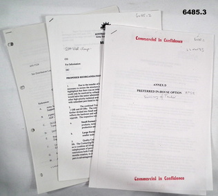 Bendigo Military Museum
Document - Army Topographic Support Establishment: Preferred In-House Option, 1 23 Nov 1993, .2 30 Nov 1994, .3 14 Jun 1995
.1 The Preferred In-House Option (PIHO) proposes to meet the full requirements of the Request for Tender (RFT) by disestablishing Army Survey Regiment and establishing a new organisation which they have named the Defence Topographic Support Establishment (DTSE). It is proposed to locate the DTSE at Bendigo in the GFE facilities offered by the Commonwealth. The DTSE will be staffed by 140 Defence civilians, principally sourced from ex-RASvy members transferring to the Public Service under the provisions of Section 81B of the Public Service Act. Any existing civilian members excess to DTSE requirements are proposed to be managed within the terms and conditions of the Australian Public Service Redeployment and Retirement (Redundancy) Award 1987. Military members who elect to remain in the Service will be subject to redeployment or retraining in accordance with Service requirements. .2 Proposed re-organisation of Product Construction Squadron (PCS). Due to the transfer of Image and capture Sections to Digital Acquisition Squadron wef Jan 1995 it has been necessary to review the structure of those elements remaining within PCS. The review highlighted that there was an imbalance between Mapping and Digital products Troops. This could only be resolved by collapsing these two Troops into one single production element. This would halve the senior administrative personnel needed thus allowing them to be employed in other higher priority technical areas. The proposed restructure of PCS is outlined in Annex A with redundant personnel listed in Annex B. The combined Troop is to be designated "Construction Troop" and comprises 1 Offr and 69 ORs. The role of this Tp would be to perform all digital production. It is further divided into small and Large Format Sections. This division is functionally based and reflects the hardware and software configurations now resident within the Sqn post system upgrade. .3 During the transition period leading to full implementation of the PHIO, the Army Svy Regt and DTSE (later ATSE) will at times operate concurrently whilst Army Svy Regt scales down production and progressively transfers all technical functions to DTSE. army Svy Regt and 4 Fd Svy Sqn will continue programmed production activities until declared operationally ineffective, however a contingency mapping capability will be maintained throughout the period of implementation. Implementation of the PHIO involves a number of related activities including staff recruitment, equipment acquisition and transfer of technical responsibility. This instruction details the coordination of these and related implementation activities. .1 Preferred In-House Option, Army Topographic Support Establishment. Summary of Tender. 10 x pages typed text and schematic diagrams. .2 Proposed reorganisation - product Construction Squadron. 9 x pages typed text and schematic diagrams. .3 Implementation of the Commercial Support Program (CSP) Digital Topographical support to the Australian Defence Force (ADF). Preferred In-House Option 14 Jun 1995. 22 x pages typed text and schematic diagrams. royal australian survey corps, rasvy, fortuna, army svy reg, army survey regiment, atse -
 Eltham District Historical Society Inc
Photograph, Peter Pidgeon, Official opening of the restored Eltham Courthouse, 730 Main Road, Eltham, 23 Mar 2022
Eltham Courthouse Officially Reopened (Jim Connor, EDHS Newsletter No. 263 April 2022) In the Conservation Management Plan prepared in 2006 for the Eltham Justice Precinct there is mention that more than 350 court houses have been built by the Public Works Department since 1856, when the Department was established. It also states Eltham was in an early group of 'Victorian Free Classical' structures, featuring a projecting entry porch and gabled roof. Characteristically, this group shares a simple, rectangular shape, central placement of the court room with smaller-scale offices set back at the sides or rear of the court room, arched openings, and decorative string courses. The Statement of Significance listed in the Victorian Heritage Register states: ‘The Eltham Court House dates from the time when the town was largely self-contained. It was initiated in response to itinerant gold prospectors who turned to crime when their quest was unsuccessful. This type of localised solution is characteristic of the self reliance preserved in Eltham today. The court house is an important symbol of the spirit which makes Eltham distinctive as a community.’ It also states: ‘The Eltham Court House, built in 1860, is one of only two intact examples in the state of this simple design with projecting entry.’ So with this background it is most appropriate this valued historic building has recently been the subject of a total restoration, as detailed in previous newsletters. This was a major project undertaken by Nillumbik Shire Council. At a small function in the Eltham Courthouse, on 23rd March 2022, Nillumbik Shire Council Mayor Fran Eyre declared the fully restored building officially reopened. In doing so the Mayor spoke about the earlier law and order function of the court and the importance of this building to the Eltham community. Wingrove Ward Councillor Geoff Paine then highlighted the importance of historical societies and groups within the shire and their valued activities in recording and preserving their local history. EDHS president Jim Connor thanked everyone involved with the project and provided an overview of the history of the courthouse. Michael Ioannides, Council’s project manager, spoke about how the restoration process proceeded and those involved in undertaking the works required. Cr. Natalie Duffy, various council officers, EDHS executive committee members, as well as representatives of the head contractor Ducon Building Services and the heritage advisors, RBA architects and Conservation Consultants, were also in attendance, as was a representative of Nillumbik U3A. After the formal part there was some light hearted interpretation of how past legal proceedings may, or may not have, occurred within this courthouse, before some refreshments were shared in the former second courthouse at the rear, which is now utilised by Nillumbik U3A. This was a successful celebration of a very worthwhile project.Born digital image (38)conservation consultants, cr. geoff paine, cr. natalie duffy, ducon building services, eltham courthouse, eltham district historical society, eltham justice precinct, jim connor, mayor cr. fran eyre, michael ioannides, nillumbik shire council, nillumbik u3a, opening ceremony, rba architects, restoration project -
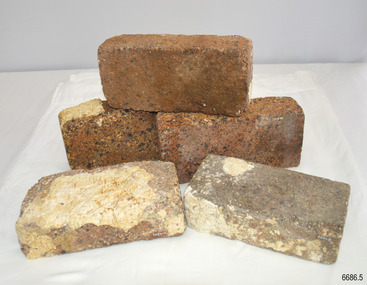 Flagstaff Hill Maritime Museum and Village
Ceramic - Clay Bricks, Circa 1838
These bricks are a sample of “5000 house bricks from London” carried by the CHILDREN as ballast, and intended for the Portland Bay settlement of her owners Henty Bros. Flagstaff Hill divers recovered them from Childers Cove in February 1974, and noted, “These bricks are the major feature of the wreck site. Subsequent notes indicate “The hull structure has broken up, leaving few visible remains, except for piles of house bricks intended for the Hentys of Portland”. According to Lloyds Shipping Register 1837-1839, the CHILDREN was built in 1825 at Liverpool and operated by owners Gordon & Co, of London, London registered number 123/1837; James Henty then bought her in 1837 as a three-masted barque of 254 tons, with a hull of “part pitch pine, felt sheathed” and “coppered 1837”. Launceston registered number 6/1837; in 1838 the CHILDREN, under her master Captain H. Browne, completed a successful round trip from Launceston to London (carrying wool and whale oil loaded in Portland), returning in late November of that year (carrying general cargo including the house bricks). On the 11th of January 1839, the CHILDREN sailed from Launceston for Adelaide, with 24 passengers, 14 crew, and an awkward mixed cargo, including 1500 sheep, 8 bullocks, 7 horses, and farming implements, and six whaleboats with associated whaling gear. One account states that when the CHILDREN “put out from port she was light and badly ballasted”. The vessel immediately encountered four days of hurricane-force storms, eventually clearing on the early morning of the 14th to “west force 10”, but too late to take accurate measurements of the sun or stars to establish their position relative to the coast. The CHILDREN collided with a limestone stack at the entrance of Childers Cove, and the seas smashed her into pieces within half an hour. All the cargo and 16 lives were lost (including 8 children). The Hentys contributed £150 towards a fund for the 22 survivors at a memorial service held in Launceston later that year. It was a major financial setback for the Hentys, but one from which they recovered. In a submission to the Governor of New South Wales dated 24 March 1840, the Hentys summarised their work over the previous six years of settlement: “Six stations have been occupied, one at Portland Bay…three at the open country about 60 miles inland called ‘Merino Downs’…They have erected two houses at Portland Bay and two others at Merino Downs”.These bricks are significant as a sample of 5000 house bricks carried from London as ballast by the Children and were intended for the Portland Bay settlement of her owners James Henty & Co. The CHILDREN was one of the first vessels to be lost in the Western District of Victoria, east of Warrnambool, on January 14th 1838, breaking up within twenty minutes. The wreck is also significant as one of the first vessels to have been lost in the Western District of Warrnambool and as such is registered on the Victorian Heritage Register S116.Five ‘house bricks from London’, some with white marine encrustation, recovered from the wreck of the ship CHILDREN. The bricks are oblong shaped and constructed of a blue-coloured and coarse-grained conglomerate. One brick is higher, shorter and narrower, than the other four bricks.Nonewarrnambool, shipwreck coast, flagstaff hill, shipwrecked coast, flagstaff hill maritime village, flagstaff hill maritime museum, shipwreck artefact, maritime museum, london house bricks, children shipwreck, james henty and co, henty brothers, childers cove, early shipowreck -
 Melton City Libraries
Photograph, Melton Uniting Church Opportunity Shop volunteers, 1993
In the early l 970's , when our population was increasing rapidly and resident ministers were needed at both Melton and Bacchus Marsh, and after discussion between both denominations over many months a decision was reached , that in both areas they would unite and be known as Methodist - Presbyterian joint parishes. In 1972 Ministers were appointed, and Melton's minister occupied one of the Bacchus Marsh Manses during the building of Melton's church residence in Y uille Street. Services were held at Scots Presbyterian Church Melton. Youth Club and church meetings were held in the Methodist Church at Brooklyn Road, Melton South. At a joint Parish Committee Meeting held in May 1975 at Melton South - a major item of business was finance, to meet the repayments on the recently built Church Manse and the minister's Stipend. The meeting closed without any solution to this problem being made. As the men restacked the chairs Maisie and I viewed the building with the possibility of opening an Opp Shop on the premises. We then made the suggestion to the other members and during the forthcoming weeks investigations concerning the feasibility of this idea were made, volunteers recruited and the shop opened in July 1975. The first contribution to the Church funds of $1,600 was made in 1976 and was followed by regular contributions to the church budget each year. In 1981 a 30'x 20' steel garage costing $2,000 was erected adjacent to the original Methodist Church to provide more space. Meanwhile an Opp Shop was opened in Melton Markets and operated from 1981 to 1985. Further accommodation was needed at Yuille Street and the Atco Hall was installed at the rear of the Bluestone Church (known as Melton Uniting Church - 1977). A large proportion of finance for this project was contributed by the Opp Shop $16,000. Simultaneously finance was being built up to provide further facilities at Brooklyn Rd, resulting in the commencement of a concrete block masonry and steel extension, with facilities & fittings, being commenced during 1986 & completed in 1989. The approximate total cost of this structure was $60,000. Over the 16 years, members and friends of our church have contributed many many hours to staff the shop and many other supportive works. As an acknowledgement of their efforts, our Minister prepared Certificates for Service and Dedication which were presented to 75 supporters at a special Church Service in June 1991. The assistance that has been given to the community of Melton & District has been extensive and much appreciated by many families. In addition many appeals for goods and clothing have been received and packages sent to many outside supportive agencies. Three volunteers having a tea break in the staffroom of the Op Shoplocal identities, churches -
 Victorian Aboriginal Corporation for Languages
Periodical, Australian Institute of Aboriginal and Torres Strait Islander Studies, Australian Aboriginal studies : journal of the Australian Institute of Aboriginal and Torres Strait Islander Studies, 2007
1. The moral lexicon of the Warlpiri people of central Australia LR Hiatt This paper discusses words that match ?Good? and ?Bad?; examples of ?Good? and ?Bad? behaviour; morality and law; and egalitarianism and dominance. It also presents a comparison with Gidjingarli (Burarra). 2. Mobs and bosses: Structures of Aboriginal sociality Patrick Mullins (Mount Druitt, NSW) A commonality of Aboriginal social organisation exists across the continent in communities as different as those from the Western Desert across to Cape York, from the towns of New South Wales and Western Australia to cities like Adelaide. This is found in the colloquial expressions ?mob? and ?boss?, which are used in widely differing contexts. Mobbing is the activity where relatedness, in the sense of social alliances, is established and affirmed by virtue of a common affiliation with place, common experience and common descent, as well as by the exchange of cash and commodities. Bossing is the activity of commanding respect by virtue of one?s capacity to bestow items of value such as ritual knowledge, nurturance, care, cash and commodities. Mobbing and bossing are best understood as structures in Giddens? sense of sets of rules and resources involved in the production of social systems, in this case social alliances. Mobbing and bossing imply a concept of a person as a being in a relationship. Attention needs to be given to the way these structures interact with institutions in the wider Australian society. 3. Recognising victims without blaming them: A moral contest? About Peter Sutton?s ?The Politics of Suffering: Indigenous Policy in Australia since the 1970s? and Gillian Cowlishaw?s replies Ma�a Ponsonnet (Universit� Paris- 8-Saint-Denis) Peter Sutton?s texts on Aboriginal violence, health and their politicisation are replied to using his methodology, and acknowledging his convincing points. Sutton rightly denounces a lack of lucidity and scientific objectivity in anthropological debates. These inadequacies impede identification of what Aboriginal groups can do to improve their situations for fear that this identification would lead to blame the victims. At the other end of the ethical spectrum, those who advocate a broader use of what I will call a ?resistance interpretation? of violence fail to recognise victims as such, on the implicit grounds that seeing victims as victims would deprive them of any agency, on the one hand, and entail blame, on the other hand. I aim to define a middle road between those views: the idea that victims should be acknowledged as such without being denied their agency and without being blamed for their own condition. This middle road allows identification of the colonisers? responsibilities in the contemporary situation of Indigenous communities in Australia, and to determine who can do what. Secondly, I show that Sutton?s texts convey, through subtle but recurrent remarks, an ideology of blame rather than a mere will to identify practical solutions. As a consequence, some of his proposals do not stand on a solid and objective causal analysis. 4. 'You would have loved her for her lore?: The letters of Daisy Bates Bob Reece (Murdoch University) Daisy Bates was once an iconic figure in Australia but her popular and academic reputation became tarnished by her retrograde views. Her credibility was also put in doubt through the exposure of her fictionalised Irish background. In more recent times, however, her ethnographic data on the Aborigines of Western Australia has been an invaluable source for Native Title claims, while her views on Aboriginal extinction, cannibalism and ?castes? are being seen as typical of her time. This article briefly reviews what has been the orthodox academic opinion of her scientific achievement before summarising what is reliably known of her early history and indicating what kind of person is revealed in the 3000 or more letters that she left behind. 5. What potential might Narrative Therapy have to assist Indigenous Australians reduce substance misuse? Violet Bacon (Curtin University of Technology) Substance misuse is associated with adverse consequences for many Australians including Aboriginal and Torres Strait Islander peoples. Extensive research has been conducted into various intervention, treatment and prevention programs to ascertain their potential in reducing substance misuse within Aboriginal and non-Aboriginal communities. I explore the potential of Narrative Therapy as a counselling intervention for assisting Indigenous Australians reduce the harm associated with substance misuse. 6. Bone points from the Adelaide River, Northern Territory Sally Brockwell (University of Canberra) and Kim Akerman (Moonah) Large earth mounds located next to the vast floodplains of the lower Adelaide River, one of the major tropical rivers draining the flat coastal plains of northern Australia, contain cultural material, including bone points. The floodplains of the north underwent dynamic environmental change from extensive mangrove swamps in the mid-Holocene, through a transition phase of variable estuarine and freshwater mosaic environments, to the freshwater environment that exists today. This geomorphological framework provides a background for the interpretation of the archaeology, which spans some 4000 years. 7. A different look: Comparative rock-art recording from the Torres Strait using computer enhancement techniques Liam M Brady (Monash University) In 1888 and 1898, Cambridge University?s Alfred C Haddon made the first recording of rock-art from the Torres Strait islands using photography and sketches. Systematic recording of these same paintings and sites was carried out from 2000 to 2004 by archaeologists and Indigenous Torres Strait Islander and Aboriginal communities as part of community-based rock-art recording projects. Computer enhancement techniques were used to identify differences between both sets of recordings, to reveal design elements that Haddon missed in his recordings, and to recover images recorded by Haddon that are today no longer visible to the naked eye. Using this data, preliminary observations into the antiquity of Torres Strait rock-art are noted along with recommendations for future Torres Strait region rock-art research and baseline monitoring projects. 8. Sources of bias in the Murray Black Collection: Implications for palaeopathological analysis Sarah Robertson (National Museum of Australia) The Murray Black collection of Aboriginal skeletal remains has been a mainstay of bio-anthropological research in Australia, but relatively little thought has been given to how and why this collection may differ from archaeologically obtained collections. The context in which remains were located and recovered has created bias within the sample, which was further skewed within the component of the collection sent to the Australian Institute of Anatomy, resulting in limitations for the research potential of the collection. This does not render all research on the collection unviable, but it demonstrates the importance of understanding the context of a skeletal collection when assessing its suitability for addressing specific research questions.maps, b&w photographs, colour photographs, illustrations, graphs, chartswarlpiri, sociology, daisy bates, substance abuse, narrative therapy, rock art, technology and art, murray black collection, pleistocene sites, watarrka plateau -
 Eltham District Historical Society Inc
Film - Video (VHS), Diamond Creek Fire Brigade, c.1955-1987
Combination of three movie films. Movie One (1950s): 00:00 – 13:14 Black and white footage of Diamond Creek firemen practising in Diamond Street in the 1950s for forthcoming demonstrations of abilities. Mentions of Gordon Brandy and Joe Hislop Running out hoses from old hose reels along Diamond Street, Diamond Creek Displays from various brigades running out and connecting hoses. Also scenes from the 1950s of Diamond Creek Fire Brigade competing in various locations around Victoria and Tasmania. Mentions of Brigade members Dave Kidd, Bruce Hackett, Ron Kirkbride, Jack Marks, Graham Upton who are prominent in these events. Members of Kyneton Fire Brigade also present. Members competing in running out hose reels, connecting hoses togethers and to hydrants then climbing towers to direct water from hose or at a target hanging above the road. Diamond Creek members identified wearing a diamond on their chest and back. Includes scenes of Scottish pipe bands at the events and significant crowds of spectators. Footage of Mel Stone and Beryl Marks, Stan Redpath and Ron Kirkbride, then Ron Kirkbride and Eric Holt viewing flower displays. Film changes to colour at Diamond Creek oval for practice with fire engine entering oval. Members depicted include Bill May, Jack Sinclair, Jim Cox, Bob Beale, Dave Kidd, Bruce Hackett and Captain Clarrie Stone. Reverts to black and white in the 1950s where the Brigade joins forces with the Diamond Valley Community Hospital for a Gala Day on the Diamond Creek Oval. Changes to colour again, possibly same event and scenes of children on bikes and scooters or with prams and carts racing around the oval. Mention of young lad Brian Laurie who has his own fire truck. Dart throwing, pony rides. Scenes with Dr Don Cordner, Gus Lyons, Vic Cohn (?) and spinning wheel and Diamond Creek School children entertain a large crowd with Maypole dancing. Movie Two (1950s): 13:25 – 19:00 This black and white film was taken by a TV film crew in the 1950s depicts a typical call out for the Diamond Creek Fire Brigade. In this case the careless action of a member of the public throwing a lighted match from a car, which can cause extensive damage. Footage features the Shire of Eltham War Memorial tower at Kangaroo Ground before it was modified with a fire spotter’s cabin. Discusses fire spotting operations from the tower. Shows a fire spotter walking around the top of the tower. A fire is detected, and the information is relayed to the nearest fire station, in this case, Diamond Creek. The telephone call is received, and the alarm sounded. Captain Clarrie Stone and firemen May and Shaw leave their workplaces and prepare for action. Scenes of running across the Main Hurstbridge road showing the shops (Shell service station and Chemist prominent). Scenes entering the fire station which has a pictorial warning covering the entire door “Only you can prevent forest fires – If you’re careless – we’re homeless!” Eric Holt pinpoints the location of the fire while Captain Clarrie Stone and Fireman Shaw take note. The advance vehicle (an FE Holden ute, rego GTE-696) leaves to assess the extent of the fire. Having assessed the fire, Fireman Shaw communicates with base showing radio with call sign VL3JZ. Eric Holt takes the call. In the meantime, Captain Clarrie Stone and Fireman Shaw undertake some limited action to address the fire. Firemen Bill May, Jim Bates and Hugh Bar (?) man the tanker. A photo portrait of Queen Elizabeth is visible hanging on the wall. They are later joined by Firemen Jim Cox, Eric DeBuse (?) and Jack Marks. The tanker is seen departing the station and diverging off before the bridge. Captain Clarrie Stone and Fireman Shaw are seen pumping water on the flames with hand pumps when the tanker arrives. The hose is unreeled, and water turned on the flames. Jack Sinclair joins the action. Jim Cox directs water to the high stuff. The fire put out, Jack Marks and Eric DeBuse wind in the hoses and the team head back to town. It’s peaceful again at the memorial tower. Movie Three (1969-1987): 19:14 – 34:34 Colour film “Fired with Dedication”, Country Fire Authority Victoria, produced by I.L. Wadeson, Commentary by A.M. Hem. Credits with CFA Victoria emblem and then placed over a view of an old-style ladder engine. Opens with the scene of a fire engine outside the Diamond Creek Fire Station then various trophies reflecting the competition success of the brigade in various track and disciplined events. Two trophies shown of particular pride to the brigade were for first place in the Torchlight Procession at the State Championships in Mildura in 1986 and also at Swan Hill in 1981. Still photo scenes of ex Captain Clarrie Stone, Brigade Captain for 21 years; ex Captain Jack Marks, 10 years; ex Captain Ian Douglas, 10 years. Cuts to scene of radio control room, January 1969, and news of a fire on the northern side of the township of Diamond Creek. With scenes of flames in bush, the narration explains that until the early 1960s the area was an orchard district which protected the town against the savagery of bushfires. But due to competition from other areas more suitable for orcharding and easier transport to Melbourne the district could no longer remain competitive, and orchards were replaced by grassed areas, which together with the bush areas were a feeding ground for fire. On 8th January 1969, high temperatures and strong north winds, were, with the carelessness of some individual all that was necessary to produce the worst fire the district had seen. Cuts to scene of blackened fields and cattle - Hundreds of hectares of grass land were blackened, and cattle had to be transported to other areas for agistment. Scene of destroyed buildings in the township – 13 houses and the public hall in the town were destroyed as was the theatre equipment which was owned by the fire brigade. The Church of England Hall and bell tower were badly damaged. The whole town could have been burnt out but for the determination, skill, and courage of the Diamond Creek Fire Brigade. Scenes of all that was left of the home on the hill on the west side of the Church of England. Also, the remains of the old Pisy (?) home on the top of the same hill near Lambert Street, and the ruined Crocker home. Cuts to a scene in the mid-1970s to mid-1980s of a house fire in Haley Street attended by the Diamond Creek Fire Brigade. Although the house was severely damaged, it was saved. Mentions that whilst assistance is appreciated, in some circumstances, those doing so are not properly dressed for fighting fires. Breathing apparatus is a must in structure fire attack. Next scene (either on Mangarook or Coventry oval) showing off four Diamond Creek Fire Brigade efficient and very expensive firefighting units. Features a forward control vehicle Toyota 4WD used for conveying task force personnel to the required areas; a Hino Model 3.2 tanker, diesel powered and carries 3,000 litres of water and has a 16 HP petrol driven pump which delivers 900 litres of water per minute; an International tanker (registration TCM-418) which carries 3,000 litres of water with pumping capacity of 600 litres per minute. The Ford diesel powered pumper (registration MXE-754) is a well-equipped vehicle with a water capacity of 1,000 litres and capable of pumping 1,900 litres of water per minute from the main pump, has many lockers which hose equipment such as breathing apparatus and various types of hose nozzles and foam making equipment. The vehicle carries 360m of 64mm diameter hose which can be laid out from the rear lockers and a portable lighting plant, an Oxy Viva resuscitator to revive smoke inhalation victims and forcible entry tools to gain access to structure fires. Views of the main pump and control panel on the vehicle. As well as the main pump, the vehicle is equipped with an auxiliary pump which allows the facility to pump whilst moving. Fire fighters must undergo constant training and hone their skills, Scenes of a training exercise using the pumper to pump from static water. First, the short lengths of suction hose are coupled, a strainer fitted to ensure debris does not foul the pump. Gauges must be constantly monitored to ensure manageable water pressures are maintained. Pressures are normally controlled to allow two fire fighters to work at each nozzle outlet. Two nozzles are tested, one adjustable jet fog type which is used on flammable gasses or within a structure fire to absorb heat. A straight jet nozzle to project water long distances to protect exposed surfaces close to a fire radiated heat. The pumper is quite a versatile vehicle in handling structure fires, but it also carries specialist equipment needed in containing hazardous chemical incidents. Cuts to scene of parade – the Diamond Creek Fire Brigade has with other neighbouring brigades participated in most town fairs and earns the respect of the watching public. It can be seen why this brigade has been so successful at disciplined contests. Views of Plenty Fire Brigade Road Rescue unit which is equipped with the “Jaws of Life” Scenes of athletic competitions – many neighbouring brigades indulge in friendly but keen competition at the Diamond Creek Town Fair. The young are also encouraged to participate in all aspects of Junior Fire Brigade activities and become tomorrow’s generation of volunteer fire fighters. Scene of the 1986 Diamond Creek Town Fair which was the last time veteran Captain Clarrie Stone BEM marched with the brigade. Clarrie was awarded the British Empire Medal for his service to the Country Fire Authority. Also, scenes of vehicles in the parade. Cuts to scene of brigade members in drill formation for inspection by Acting Chief Harry Rothsay (?) on the occasion of the opening of the new fire station extensions on August 29, 1987. Rudy Libel (?) Captain at the time. Scenes of crowds including many dignitaries of neighbouring brigades present including Lieutenant Gordon Grandy (who came down from Queensland for the occasion) and ex-Secretary David Kidd and wife Betty, also ex Captain Clarrie Stone and Mrs Nel Stone, a life member of the Ladies Auxiliary, the Reverend Jock Ryan, son of J.L Ryan, founder of the Diamond Creek Fire Brigade, Foundation Captain of the fire brigade, Keith Bradbury and Mrs Bradbury. Pauline Dick accepts a community service award for services to the CFA. Recognising over 47 and a half years of service, a presentation is made by Mr Neil Marshall, Acting Chairman of the CFA to ex Captain Clarrie Stone with response by Clarrie. Other members of the official party include Cr. Martin Wright, Shire President Wayne Phillips and local Member of Parliament, Mrs Pauline Toner. Ex foreman John Bennett is presented with a life member’s awards by Captain Rudy Libel. The camera also catches Gwen Cox, Jean Ryan and Bessie Layton (?) Provides historic footage of people, places and equipment and a record of the worst fires expoerienced in Diamond Creek in 1969BASF Standard Quality SQ E-180 VHS dubbing (poor quality) of three films Converted to MP4 file format 0:34:38, 1.85GBOn label: "Donation - August 2000 Diamond Creek Unit Old films made up from Fire Brigade shows at competitions - also Kangaroo Ground Tower being used"video recording, diamond creek fire brigade, 1986 diamond creek town fair, a.m. hem, acting chief harry rothsay, athletic competitions, beryl marks, bessie layton, betty kidd, bill may, bob beale, brian laurie, bruce hackett, captain clarrie stone, chemist, church of england hall, clarrie stone, clarrie stone bem, country fire authority victoria, coventry oval, cr. martin wright, crocker home, dart throwing, dave kidd, david kidd, diamond creek, diamond creek fire station, diamond creek oval, diamond creek school, diamond creek town fair, diamond street, diamond valley community hospital, dr don cordner, eric debuse, eric holt, fe holden ute, fire damage – buildings, fire spotter, fire spotter’s cabin, fire station extension, fired with dedication (film), firefighting units, fireman shaw, firemen jim cox, ford pumper, foundation captain, gala day, gordon brandy, gordon grandy, graham upton, gus lyons, gwen cox, haley street, hino model 3.2 tanker, house fire, i.l. wadeson, ian douglas, international tanker, j.l ryan, jack marks, jack sinclair, january 1969, jaws of life, jean ryan, jim bates and hugh bar, jim cox, joe hislop, john bennett, kangaroo ground, kangaroo ground tower, keith bradbury, kyneton fire brigade, lambert street, main hurstbridge road, mangarook oval, maypole dancing, mel stone, mildura 1986, mrs bradbury, mxe754 vic registration, neil marshall, nel stone, orchard district, oxy viva resuscitator, pauline dick, pauline toner mp, pisy home, plenty fire brigade road rescue unit, pony rides, radio control room, reverend jock ryan, ron kirkbride, rudy libel, shell service station, shire of eltham war memorial, shire president wayne phillips, spinning wheel, stan redpath, state championships, swan hill 1981, tcm418 vic registration, torchlight procession, toyota 4wd, trophies, vic cohn, victorian bushfires - 1969, vl3jz