Showing 77255 items matching "black "
-
 Eltham District Historical Society Inc
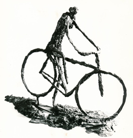
Photograph, Sculpture, Cyclist, Gareth Jones-Roberts
Black and white photograph reproduced on p123 of 'Pioneers & Painters'pioneers and painters, artists, gareth jones roberts -
 Eltham District Historical Society Inc
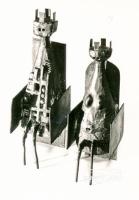
Photograph, Gus McLaren: Chessmen
Black and white photograph reproduced on p130 of 'Pioneers & Painters'pioneers and painters, sepp, artists, gus mclaren -
 Eltham District Historical Society Inc
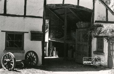
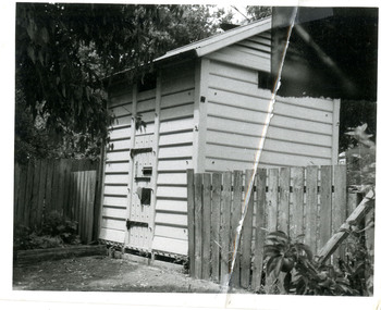
Photograph, Montsalvat
Black and white photograph looking in to entrance of stables at Montsalvatpioneers and painters, montsalvat -
 Eltham District Historical Society Inc
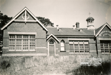
Photograph, School
Black and white photograph of unknown school, possibly Fitzroyschools -
 Doncaster RSL Sub Branch
Minute Book, Doncaster Sub-branch First Minute book - 1919
Book includes the Constitution the sub - branch Rules and minutes of 15 meetings from 9th June 1919 to7th February 1920 all in hand writing.Standard school exercise book black outer cover -
 Warrnambool and District Historical Society Inc.
Document, Certificate Mr H Goodall, 1944
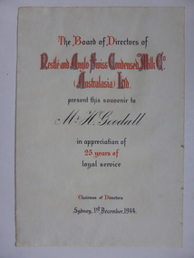
This certificate was awarded in appreciation of 25 years service to the Nestle Company which operated a dairy factory at Dennington in Warrnambool. The company came to Warrnambool in 1907 and purchased 17 acres at Dennington and a new dairy plant was established by 1911. At its peak it employed 600 people and processed 55000 gallons daily in the milk condensery which is a process whereby much of the water content is drawn from the milk and sugar is added making a product which has a long shelf life and because it is processed at low temperature the milk maintains much of its vitamin content.A certificate which links a local person to a long and well known industry in Warrnambool and the Western district.Cream soft card certificate with red and black text.Mr H Goodall. Nestle and Anglo Swiss Condensed Milk Co Australasia Ltd. dated 1st December 1944. The signature of the Chairman of directors is unreadable.warrnambool, nestle dennington, h goodall -
 Victoria Police Museum
Police Stations (Alexandra)
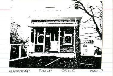
Alexandra is a regional centre in the Shire of Murrindindi in Victoria, Australia and 130 kilometres north east of Melbourne. Alexandra Police Station opened in the Benalla Police District on 8 May 1867 in Bon Street, on the north side near Grant Street. When the station opened it was staffed by one Senior Constable; one 1st Constable (Mounted); one Foot Constable. The original building was a nine-roomed brick building with an iron roof on land measuring 84' x 97’. The house included a wash-house, pantry, bathroom, office, one W.C., stabling for three horses, a lock-up with two rooms and a single man's room. It closed in June 1977 and was replaced by a new police station which opened on 16 June 1977 in Bon Street, on land adjacent to the old police station. For a list of Officers in Charge 1871 to 1943 contact Victoria Police Museum1 black and white photo and 3 colour photospolice stations; alexandra police station -
 Victoria Police Museum
Police stations (Aitken's Gap)
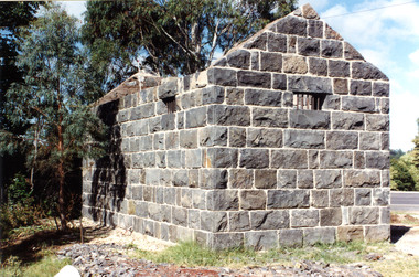
Aitken's Gap, otherwise known as The Gap or Buttlejork, and 3km west of Sunbury, was established as a township in 1845. It is in the area which is now bordered by the Calder Highway and Gap Road. The village was named after John Aitken, a Port Phillip pastoralist who took up the Mount Aitken run in 1836. Aitken's Gap Police Barracks (in the District of Bourke) opened in 1853 and was staffed by two Mounted Constables and one Foot Constable. The gaol (used to house prisoners and also gold en route to Melbourne) was built in 1857 from bluestone quarried in the area. The roof was made of slate. In 1861 it was staffed by 1 Mounted Senior Constable and 1 Foot Constable. The Barracks closed in 1863 when the Bendigo rail line was completed and the gold was transported to Melbourne by rail. All the buildings, except the gaol, were moved to Sunbury. The land was sold in 1870 and in 1989 the current owner donated the building to the Sunbury Police. The original building was dismantled, restored and rebuilt outside Sunbury police station.15 colour photos and 1 black and white photopolice stations; aitken's gap police station -
 Victoria Police Museum
Police Stations (Apollo Bay)
Apollo Bay is a coastal town in southwestern Victoria. It is situated on the eastern side of Cape Otway, along the edge of the Barham River and on the Great Ocean Road, in the Colac Otway Shire. The original township was surveyed in 1853 and named Middleton. In 1881 the town was renamed Krambruk which was changed to Apollo Bay in 1898. The Krambruk Police Station was opened on 7 March 1888 in the Southern District on land opposite the site of the current Mechanics' Institute and changed its name to the Apollo Bay Police Station on 1 September 1990. It came under the Barwon District in 1948 and "Lima" Western District from 4 March 1990. In 1930 the police station was located to 29 Nelson Street. It was a seven-roomed weather-board dwelling on three-quarters of an acre of land. It consisted of six rooms of pine, lined and painted; one pantry; one bathroom and wash-house; one hall; one office and one W.C.. There was stabling for one horse and one cell for prisoners. It was staffed by one Mounted Constable. In the early 1970s land was acquired at 31 Nelson Street and a new police station was constructed. This was a three-roomed brick building with a cell block at the rear. By the time it closed in 2005 it had been extended twice. On 17 November 2006 the current Apollo Bay Police Station opened in its current location at 35a Nelson Street, on the corner of Cartwight Street). Outside the peak summer season, the station is open 16 hours per day and staffed by one sergeant and five other members. 3 black & white photos and 2 coloured photospolice stations; apollo bay police station -
 Victoria Police Museum
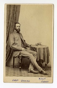
Carte de Visite (Inspector James), F.S. Crawford, Adelaide Photographic Company
Black and white carte de visite of Inspector JamesInsp. James, Kelly Escort (in blue pen under photograph)inspector frank james, edward kelly, ned kelly, kelly gang -
 Victoria Police Museum
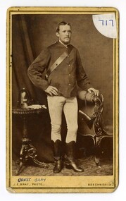
Carte de Visite (standing constable), J.E. Bray
Black and white carte de visite of a standing constableConst Bray (written in blue pen under photograph)william john richard wallace, kelly gang, edward kelly, ned kelly -
 Victoria Police Museum
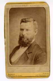
Carte de Visite (Sergeant Kennedy), Burmans Photographic Rooms
Small black and white photograph showing Sergeant KennedySergeant Kennedy (printed in ink at top), shot by the Bushrangers (very faint under image)michael kennedy, kelly gang, bushrangers, police murders -
 Warrnambool RSL Sub Branch
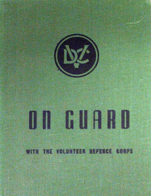
Book, ON GUARD. With the Volunteer Defence Corps
Hard Cover. Title printed in Black on Green ground Published for the Volunteer Defence Corps by Australian War Memorial, Canberra, ACT. 1944.ww2. volunteers home defence -
 Australian Queer Archives
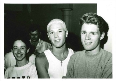
Photograph, Brother Sister Enterprises, Boo, Brad and a friend at 3Faces, c1992, c.1992
Black and white photograph of three young men in a nightclub. -
 Emerald Museum & Nobelius Heritage Park
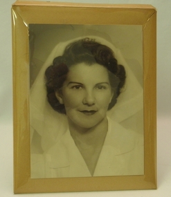
Photograph
Black and white photograph of unknown female in nurse uniform -
 Eltham District Historical Society Inc
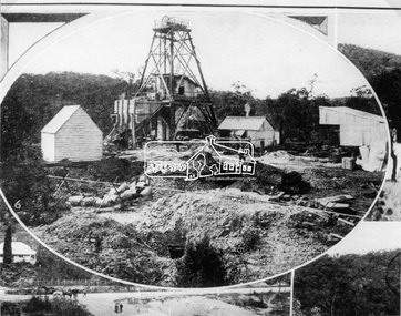
Photograph, The Australasian, Poppet-Head of the Caledonian Mine, the Warrandyte Gold Fields, 1906
Reproduced from "The Australasian" 12th May 1906, page 1115.This photo forms part of a collection of photographs gathered by the Shire of Eltham for their centenary project book,"Pioneers and Painters: 100 years of the Shire of Eltham" by Alan Marshall (1971). The collection of over 500 images is held in partnership between Eltham District Historical Society and Yarra Plenty Regional Library (Eltham Library) and is now formally known as the 'The Shire of Eltham Pioneers Photograph Collection.' It is significant in being the first community sourced collection representing the places and people of the Shire's first one hundred years.Digital image 35 mm Black and White negativesepp, shire of eltham pioneers photograph collection, warrandyte, gold mining -
 Eltham District Historical Society Inc
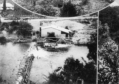
Photograph, The Australasian, The Caledonia Battery, the Warrandyte Gold Fields, 1906
Reproduced from "The Australasian" 12th May 1906, page 1115.This photo forms part of a collection of photographs gathered by the Shire of Eltham for their centenary project book,"Pioneers and Painters: 100 years of the Shire of Eltham" by Alan Marshall (1971). The collection of over 500 images is held in partnership between Eltham District Historical Society and Yarra Plenty Regional Library (Eltham Library) and is now formally known as the 'The Shire of Eltham Pioneers Photograph Collection.' It is significant in being the first community sourced collection representing the places and people of the Shire's first one hundred years.Digital image 35 mm Black and White negativesepp, shire of eltham pioneers photograph collection, warrandyte, gold mining, caledonia battery, warrandyte battery -
 Orbost & District Historical Society
photograph, 1937
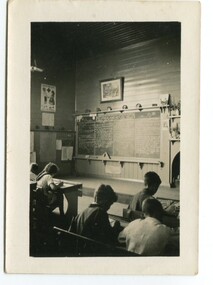
In 1912 the school at Pumpkin Point opened to serve the children of farmers living in the Bete Bolong district. This meant a big change in their way of life because in the past the children had been rowed across the Snowy River each day to attend school at Jarrahmond. Myrtle Bunting was the first HT of the school which had been erected on a block of land purchased from H. Richardson. The school functioned until 1952 when a shortage of pupils caused its closure. As a bus service to Orbost now operated, the school at Pumpkin Point faced permanent closure. J. McKeown bought the building. Students attending the school at this time included Russells, Johnstones, Reeves, Healeys, Kavanaghs, Phillips, Rodwells, Mills, Baileys, Gilberts and Masons. Mr. Oswald S. Green taught at Bete Bolong State School until he was appointed to Rokewood Junction in August 1937.This item is associated with the history of education in the Orbost district. There is no longer a school at Bete Bolong.A small black / white photograph of students sitting in a classroom.on back - "Bete Bolong School, 1937. O.S. Green was H.T."bete-bolong-school pumpkin-point green-o.s. -
 Orbost & District Historical Society
black and white photograph, 1962
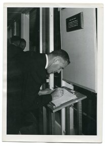
This is a photograph of Bruce Evans, Member of the Victorian Legislative Assembly, signing the visitors' book at the Orbost High School Golden Jubilee in 1962. In 2012, Orbost Secondary College and the wider community celebrated 100 years of secondary education in Orbost. With earlier levels of schooling available at the Orbost State School or nearby schools of Newmerella and Jarrahmond School, it was not until April 1912, and after much campaigning from parents and other notable community members, that the Orbost Higher Elementary School was opened. Mr Richard Trembath was appointed the new Head teacher of Orbost Higher Elementary School and was assisted by Miss Olga Hirst. The senior class consisted of 26 pupils, and the junior class, 16 pupils. A limited curriculum was available which included lessons in Latin, Arithmetic, Algebra, Geometry, Geography, History, Drawing and advanced English. (inf0. from O.S.C. website)Orbost High School / Orbost Secondary College has played a significant part in the education of senior students in the Orbost district . It is the sole senior educational institution. A black / white photograph of a man in a suit signing a book.on back - hand-written -" Orbost H. S. Golden Jubilee 1962. Bruce Evans M.L.A. signing Visitors' Book>" -
 Ringwood and District Historical Society
Photograph, Gazette Newspapers, Maroondah Highway West, Ringwood- 1975. Whitehorse Road shops
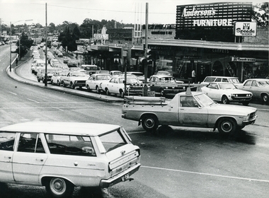
Black and white photograph. ( Photo by courtesy of Gazette Newspapers)Photo shows Anderson's Furniture, Speeds Shoes, Flamingo fashions, Cassari Pizza, Ron Mason's Studio, and Guests. -
 Ringwood and District Historical Society
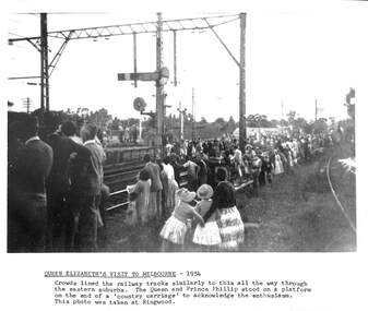
Photograph, Queen Elizabeth's visit to Melbourne 6 March 1954, 6-Mar-54
Visit of Queen Elizabeth to Melbourne 6 March 1954Black & white photograph of crowd at Ringwood Railway Station.Text under photo reads "Crowds lined the railway tracks similarly to this all the way through the eastern suburbs." -
 Orbost & District Historical Society
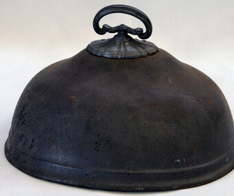
food cover, late 19th - early 20th century
Food covers were used to cover food and protect it from insects. This food cover is a simple shape and would be a domestic utensil.This food cover is an example of a simple kitchen item used in the late 19th-mid 20th century.Small black metal meat cover with small handle.food-storage domestic kitchen -
 Orbost & District Historical Society
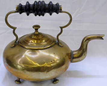
kettle, first half 20th century
Small copper kettle with carved black wooden handle.kettle cooking copperware domestic food-preparation -
 Orbost & District Historical Society
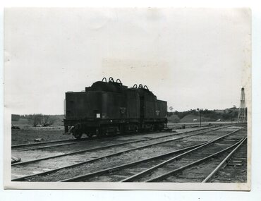
black and white photographs, second half 20th century
3151.1 is of a water tanker on stand by at Orbost ready for emergency use. Similar suppliers were at Bairnsdale and Nowa Nowa. The two tankers hels about 9,000 gallons (34068.7 litres) - from a news item in "Gippsland" September, 1971. 3151.2 is of Victoria's X class 1,800 H.P general purpose diesel electric locomotive. Si had been ordered for the Victorian Railways and cost about £ 250,000 each. 3151.3 is of several loaded, covered railway trucks on a rail line. 3151.4 was taken at the goods yard at Orbost Railway Station. 3151.5 has some rail wagons with "SHOWMOBILE COUNCIL OF ADULT EDUCATION" on the sides. 3151.6 is of goods wagons (Probably not at Orbost Station) 3151.7 is a goods train 3151.8 shows the loading or unloading of farm produce at Orbost railway Station. 3151.9 shows cattle being loaded at Orbost Railway Station. 3151.10 is of a container N.Y.K. LINE ( a Japanese shipping company) This item is associated with the history of the Orbost-Bairnsdale railway line and therefore reflects the role that the rail line played in the social and economic history of Orbost.Ten black / white photographs related to Orbost rail. orbost-railway east-gippsland-railway transport-railway railway-engine orbost-railway-station export-produce -
 Orbost & District Historical Society
black and white postcards, Sherwood, Herbert, first half 20th century
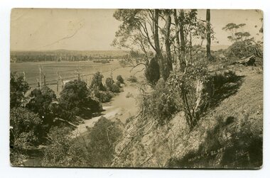
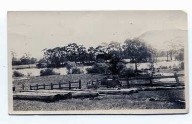
3185.1 is a view from Hofen's Bluff at Bete Bolong. 3185.2 is a view taken from Mt Raymond looking west at swampland. 3185.3 was taken from Warrens Road, Newmerella looking over the flats towards Orbost, north-east. 3185.4 was taken at Cameron's Lagoon / Lochiel Lagoon in Orbost.These postcards are pictorial records of Orbost in the first half of the 20th century.Four black / white postcards of views around Orbost. postcards-orbost hofen's-bluff newmerella lochiel-lagoon cameron's-lagoon -
 Orbost & District Historical Society
black and white photograph, February 1971
This photograph is an aerial view of the township of Orbost taken by the Bairnsdale Advertiser newspaper. It was taken from the northern end of the town. The 1971 flood was the the worst flood on record. At Jarrahmond it was at least 11 metres and up to one and a half kilometres wide on the flats causing enormous damage to the flood plain. Records say that "The brown floodwater stain in Bass Strait could be seen from passing airliners." Considerable damage was done to railway infrastructure, roads and farms. More information from the APRIL, 2008 newsletter by John Phillips. (see orbosthistory.com.au)This is a pictorial record of a significant event in the history of Orbost,A black / white aerial photograph of a township with floodwaters in the background.on back - "Note main current through the lagoon 1971."orbost-floods-1971 bairnsdale-advertiser orbost-township -
 Orbost & District Historical Society
black and white photographs, January 1934
These are photographs taken during the 1934 flood at Orbost. From The Argus (Melbourne) on January 10 1934 "Damage estimated at £500,000 has been caused by the floods in the Orbost district. No loss of life occurred, largely owing to the heroic efforts of rescue parties. Many families spent Monday night on the roofs of houses or in trees, surrounded by deep, rushing flood waters." This 1934 flood was devastating, destroying a section of the 1922 Orbost bridge - the centre span was washed away -. wrecking fences, bridges and roads, dumping silt and debris on the rich river flats and drowning cattle.These photographs are pictorial records of the 1934 floods at Orbost, a significant event in the history of Orbost.Nine small black / white photographs of flood damage,3253.2 on back - "Waters rushing down Princes Highway and....of......where you see the waves" 3253.3 on back - "rushing flood waters over Lochiel Park Bridge approach at the rear of picture 1934"orbost-flood-1934 flood-orbost -
 Orbost & District Historical Society
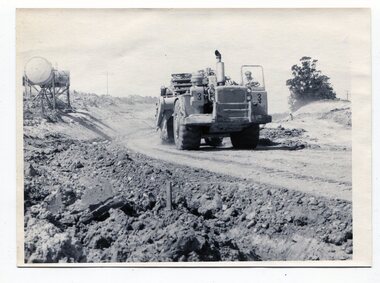
black and white photographs, C1975
These four photographs show the construction of the Princes Freeway on the eastern edge near the cemetery. of the Orbost township. The road is from the eastern entrance to the cemetery.These photographs are pictorial records of the construction of roads in Orbost.Four black / white photographs of road construction machinery.road-construction-orbost roadwork-orbost-cemetery -
 Ringwood and District Historical Society
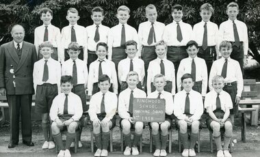
Photograph, Ringwood State School -Class photograph - Boy's 2nd Marching Squad - 1958
Black and white photograph - Boy's 2nd Marching Squad"Attached to photograph" List of student names (Incomplete) Front Row L-R : Roger Vass, ?, ?, ?, Michael Bond, Roy Carrington, ?, ?. Middle Row L-R : ?, Graeme Sinclair, Gary O'Flaherty, David Chamberlain, Cliff Goodwin, Ron Butler, Don ?, Back Row L-R : ?, ?, ?, Graeme Bruce, ?, ?, Robert McCall, Wayne Little. Teacher : Mr McCord. -
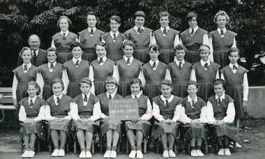 Ringwood and District Historical Society
Photograph, Ringwood State School -Class photograph - Girls 1st Marching Squad - 1958
Black and white photograph - Girls 1st Marching Squad"Attached to photograph" List of student names (Incomplete) Back Row L-R : Margaret Bowring, Pat Reid, ?, Anne Scott, Marion Giles, Olwyn Hayes, Margaret Simpson. 2nd Row L-R : Glenda McAdam, Sylvia King, ?, Ann ?, Wendy Smith, Roslyn Whitehead, Lynette Caird, ?, Maureen Reid. 1st Row L-R ; Margaret Bowring, Ann Rutledge, Norma McCann, Janet Harrison, ?, Pat Gadsden, Beverly Ratten, Lynette Evans. Teacher: Mr McCord