Showing 421 items
matching 'farm buildings
-
 Eltham District Historical Society Inc
Photograph, Liz Pidgeon, Heritage Excursion; The 1901 Eltham Railway Walk, 3 May 2014, 3 May 2014
Newsletter No. 216, May 2014 May Excursion – The 1901 Eltham Railway Walk The railway from Heidelberg to Eltham was opened in 1902. Over the previous year railway construction cut a curving swathe through Josiah Holloway’s 1851 Little Eltham subdivision. The survey plans for the railway show the owners and occupiers of land within Little Eltham affected by the railway alignment and for some distance each side. The plans show houses and other buildings but development at that time was rather sparse. Copies of these plans from the State Library of Victoria collection have been provided to the Society by Alan Sheehan. For our walk on 3rd May we intend to follow the railway from the Eltham Station to Ryans Road, which was the boundary of the adjoining Montmorency Farm. The return will be by way of nearby streets. Along the way we will discuss the details shown on the railway plans as well as more recent railway documents and photographs. At the conclusion and if time permits we can inspect the historical display at the Eltham Station. The walk is about 3 km in length and will take about 2.5 hours. It will start at 2 pm at the Eltham Railway Station car park (east/Main Road side) (Melway Ref. 21 J5).Born Digitalheritage excursion, activities, eltham district historical society, eltham railway station, eltham library, trestle bridge -
 Eltham District Historical Society Inc
Photograph, Liz Pidgeon, Heritage Excursion; The 1901 Eltham Railway Walk, 3 May 2014, 3 May 2014
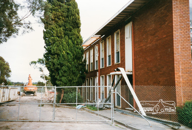
EDHS Member Doug Orford stands by a yarn bombing installation. ewsletter No. 216, May 2014 May Excursion – The 1901 Eltham Railway Walk The railway from Heidelberg to Eltham was opened in 1902. Over the previous year railway construction cut a curving swathe through Josiah Holloway’s 1851 Little Eltham subdivision. The survey plans for the railway show the owners and occupiers of land within Little Eltham affected by the railway alignment and for some distance each side. The plans show houses and other buildings but development at that time was rather sparse. Copies of these plans from the State Library of Victoria collection have been provided to the Society by Alan Sheehan. For our walk on 3rd May we intend to follow the railway from the Eltham Station to Ryans Road, which was the boundary of the adjoining Montmorency Farm. The return will be by way of nearby streets. Along the way we will discuss the details shown on the railway plans as well as more recent railway documents and photographs. At the conclusion and if time permits we can inspect the historical display at the Eltham Station. The walk is about 3 km in length and will take about 2.5 hours. It will start at 2 pm at the Eltham Railway Station car park (east/Main Road side) (Melway Ref. 21 J5).Born Digitalheritage excursion, activities, eltham district historical society, eltham railway station, eltham library, trestle bridge, yarn bombing, doug orford -
 Eltham District Historical Society Inc
Photograph, Liz Pidgeon, Heritage Excursion; The 1901 Eltham Railway Walk, 3 May 2014, 3 May 2014
Newsletter No. 216, May 2014 May Excursion – The 1901 Eltham Railway Walk The railway from Heidelberg to Eltham was opened in 1902. Over the previous year railway construction cut a curving swathe through Josiah Holloway’s 1851 Little Eltham subdivision. The survey plans for the railway show the owners and occupiers of land within Little Eltham affected by the railway alignment and for some distance each side. The plans show houses and other buildings but development at that time was rather sparse. Copies of these plans from the State Library of Victoria collection have been provided to the Society by Alan Sheehan. For our walk on 3rd May we intend to follow the railway from the Eltham Station to Ryans Road, which was the boundary of the adjoining Montmorency Farm. The return will be by way of nearby streets. Along the way we will discuss the details shown on the railway plans as well as more recent railway documents and photographs. At the conclusion and if time permits we can inspect the historical display at the Eltham Station. The walk is about 3 km in length and will take about 2.5 hours. It will start at 2 pm at the Eltham Railway Station car park (east/Main Road side) (Melway Ref. 21 J5).Born Digitalheritage excursion, activities, eltham district historical society, eltham railway station, eltham library, trestle bridge -
 Eltham District Historical Society Inc
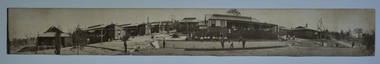
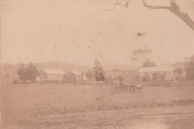
Photograph, Edendale Farm, Eltham Heritage Tour, 24 May 1992, 24/05/1992
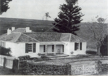
ELTHAM HERITAGE TOUR The Society excursion on 24th May 1992 was arranged by David Bick, leader of the team carrying out the Shire's heritage study. David selected a number of sites or buildings identified in the study, some of them lesser known components of the Shire's heritage. The tour commenced at the Eltham Shire Office at 10.00 am. Travel was by private car and mini-bus with stops at about twelve locations for commentary by David. It included a short walk in Hurstbridge and lunch at Kinglake. Highlights of the tour included: - 10 am Leave from Shire Offices - 3 Important Trees - A Physical Link to Eltham's First Settlers - Toorak Mansion Gates - A Surviving Farm House - An Intact Circa 1900 Main Street - First Settlers - Gold Miners, and Timber-getters - An Early Hotel - A Pioneering Homestead - Changing Eltham Shire - 20th Century - 4 pm Afternoon Tea and Finish Tour. Extract from ELTHAM CULTURAL HERITAGE TOUR (Newsletter No. 85, July 1992, by Bettina Woodburn) "The land was unprofitable for intensive farming, but there was always water in the Diamond Creek. The railway, a technological advance, followed the valley, and was provided to transport produce. At North Eltham we were privileged to tour a surviving farmhouse of the 1860-70 era at the Shire’s Edendale Farm, with the as yet unfinished Sculpture for a front fence - bulbous tree-trunks decorated with salt pots, with cross members from the old trestle bridge. As was usual these six veranda posted houses faced South (or East, away from the sun!) with the scullery, kitchen and pantry "out the back". The veranda, which must have been very narrow, no longer exists. It probably wrapped around three sides. The drive took us past the Dutch Windmill, only twenty years old and in the Shire of Diamond Valley, then the Diamond Creek Cemetery with impressive gateway, to a detour to see another old farmhouse, isolated on a hill off Murray Road Wattle Glen. Here was a particularly thick patch of exotic planting of pines and cypresses. Subsistence farming no longer pays. Following the rail-line we noticed on the left near Silvan Road an Edwardian cottage and on the right near Yates Road the old school residence for this Upper Diamond Creek area."Colour photograph1992, culture, edendale, edendale community farm, events -
 Eltham District Historical Society Inc
Photograph, Cr. Peter Graham, Mediterranean Cypress Pine trees at front of Shire office building, 12 Aug 1996, 12/08/1996
Demolition of the former Shire of Eltham Offices, 895 Main Road, Eltham, 12 August 1996. These Mediterranean Cypress Pine trees are part of the original Shillinglaw farm and stood in front of the cottage before it was relocated in 1966-67 to make way for the new Shire Office building. Originally mounted as a group of 9 photos on 42 x 55 cm display card.Colour photographeltham shire office, shillinglaw trees, demolition -
 Kiewa Valley Historical Society
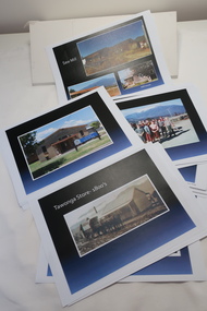
Coloured photographs on paper - Back to Tawonga 2010
These photos were collected and copied by Di Edmondson for the 'Back To Tawonga' Event in 2010 when she launched her book "Tawonga Remembers".An historical photographic collection of Tawonga and its surrounds, places and people up to 20101. Saw Mill - Mill house 2. The Rock Pool 3. People at the Rock Pool x 2 4.Old Saw mill 5. Back to Tawonga Celebrations x6 6. Tennis Curts opposite the Tawonga Store, Bakery in the background 7. Bowling Club 8. Old Guide Hall 9. The Old Boarding House 10. Old Fire Brigade Shed 11. Building the New Tawonga Memorial Hall 12. Tawonga Go Kart Track - 1960s 13. Tawonga Pony Club 1969 State Championships 14. Tawonga Recreation Reserve Newspaper article 15. The Damm Children 19. 1980s Brian Edmondson, Geoff Edmondson, Mick Harvey, David Piera. Geoff Edmondson's car 20. Tawonga Speedway Track - 1970s Mick Harvey and Paul Harkin's car 21. 2000 22. Tawonga Sports Vera Ryder and Allie Briggs 23. Tawonga School Photos x8 24. Harry Cooper's Farm Looking South 25.View from Edmondson's Farm - looking north 26. Mount Emu 27. St Aiden's Debutante Ball 27. Grand Opening Ball 1961 Tawonga Hall 28. The Kiewa Valley Road at Tawonga. Vic. 29. Tennis Courts opposite the Bogong Hotel 30.Opening of the new Toilet Block in Pioneer park 31. Old Tawonga Store x 3 32. Tawonga Memorial Hall 33. Anglican Church, St Aiden's x 2 34. Motor Khana held at Recreation reserve 35. 1970 State Champioships Team 36. Kiewa Valley School Sports at Dederang 37. Miscellaneous photos x27 Some photos have headings and some headings have been writtentawonga remembers, back to tawonga 2010, di edmondson -
 Kiewa Valley Historical Society
Photos - King Family Collection
The King family lived in Tawonga South where my older brother and sister went to school. We lived over the road from Wally Madison's farm. Later when a house became available, we moved into Valley Avenue, Mt Beauty. This is when I turned 5 and started my schooling. It was a long walk for a 5 year old as I remember. Then later we moved to 50 Lakeside Ave. I remember we loved living there as it was close to the school, footy ground and kindergarten. My father, Ted King, wad a carpenter and was involved in the building of many houses in Mt Beauty which was the home for the workers on the Kiewa Electric Scheme. So as they are part of the history of Mt Beauty I thought they may be useful to you as part of the history. The tennis photos, I vaguely remember Lou Hoad and Ken Rosewell giving exhibition matches in Mt Beauty. I may stand corrected on this, but I do remember my parents who were keen tennis players themselves were most excited at seeing these famous tennis players. As I was only 9 when we left Mt Beauty to live in Dimboola I still remember the shock of leaving a beautiful mountainous county side and arriving in a flat farming land next to a desert and seeing windmills One thing I do remember from school is, once a week (or fortnight) the teacher used to come around with a jar of little white pills, of which we were all to take. I really don't know what they were?? or for?? I also remember being taught to swim in the freezing cold river by a Mrs Smith who wore black bathers and wore her hair in a bun...... ...I am now in my 70s My father used to also carve intricate trays and jewellery boxes in his spare time. I think they were used for tennis trophies. by Diane Werner.x33 photos of small black and white photos of the Tawonga, Tawonga South and Mt Beauty - Photos not labelled but described as follows. See each photo for a possible label. A. Tawonga? B. Mt Beauty taken on the road to Bogong ? C. SEC Works D. Industrial buildings with mountains in the background E. Building site with wooden frame and 3 men F. Buildings with power poles G. Building site with lots of huts H. Buildings under construction I. Group of houses in the distance J. Group of houses in the distance K. Group of people in front of a building L. Group of 8 men sitting on timber planks, corrugated iron at back. M.& N. Building site with floor and upright timbers O. Mountain view with camp site in foreground P.& Q. Buiding site, several houses R.5 men at a building site S. portable building on trailer T & U. Mountain view V. Building site W. Group of men, car and mountains in background X. Cows Y. Pigs Z. 2 men standing next to cars. AA. Football players BB. Man painting a corrugated iron building CC. Football DD. Men in front of a building EE Buildings with mountains in background FF & GG Tennis payersHH & II. Electricity infrastructure -
 Kiewa Valley Historical Society
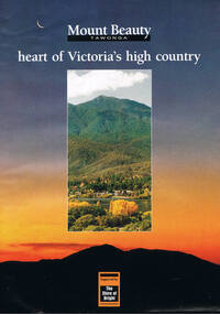
Poster Brochure, Mt Beauty Tawonga Heart Of Victoria's High Country, Circa 1995
The Item is a pictorial time piece of the valley and usage, farms,industry,town area, vegetation and winter snow levels Historical and the social-economical development at circa 1995 of land usage and residential buildings style.Major social events e.g. Festival of the Bogong Moth and the Mt Beauty Mardi Gras. It is also a good historical record of tourism campaigns of the Alpine Shire and Mt Beauty Chamber of Commerce. Also see "KVHS 0125"Brochure folds out from a 20.5cm x 29.5cm to 82cm x 29.5cm poster type documentinside panoramic photo of snow tipped alpine mountain range incorporating the Mount Beauty township, farming area of the Kiewa Valley and relevant tourist orientated informationtourism mt beauty tawonga photographs, victorian alps -
 Eltham District Historical Society Inc
Folder, Andrew
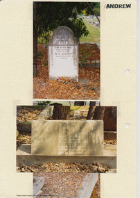
James Andrew Kangaroo Ground, 1870 "James Andrew, Whittlesea, born in East Palford, Devonshire, England, in 1827, arrived in Adelaide in February 1850 per ship Lady McCaughton and almost immediately sailed in a coasting vessel to Melbourne, where the first work he undertook was clearing earth from a stone quarry in Collingwood. He next carried stones for masons engaged in building the Bishop’s Palace, and then was employed in Cambellfield mowing hay. He was at Saltwater River on Black Thursday, and afterwards took a little farm at Darebin Creek, remaining there for four years. He went up to Kangaroo Ground in 1859 and lived there until he bought his present property at Whittlesea, a farm of between 300 and 400 acres. He has been twice married, and had a family of six children." "Andrew, W. B. Eltham, is a native of England, born in 1822. Coming out to Australia in 1842, he lived in Brighton, Victoria for fifteen years, when he re-visited England for a year. Returning to Victoria fourteen or fifteen years ago, he commenced storekeeping at Eltham, where he has carried on that business ever since. Mr Andrew has always taken a lively interest in the public affairs of town and district” from "Victoria and its Metropolis: Past and Present" written in 1888 by Alexander Sutherland. Chapter 19, "The Upper Yarra District" pages [402] - 415. Includes descriptions of some townships and short biographies of local residents. Page 405 Folder of information on James Andrew, Trustee Kangaroo Ground Cemetery, Kangaroo Ground 1870 William Bravery Andrew, Eltham, 1870s-1880s Ernest James Andrew, Eltham, Eltham Shire Councillor, 1920s-1950 and Ellen Matilda Brown Andrewjames andrew, pioneer, kangaroo ground, ernest james andrew, william bravery andrew, ellen andrew, eltham cemetery, biography, ellen harper andrew (nee clarke), ellen matilda andrew (nee brown), eltham war memorial gate, eltham war memorial trust -
 Eltham District Historical Society Inc
Folder, Ewen Cameron
Cameron, Ewen Hugh, M.L.A.., J.P. Kangaroo Ground, is a native of Inverness-shire, Scotland, and came out to Victoria in the ship Hurricane, 13th September, 1853. After he had been engaged for two years int eh building trade in Melbourne in company with is two brothers, since dead, he carried on storekeeping for several years at the Caledonia gold diggings. In 1860 he purchased 80 acres of land at Kangaroo Ground, where he now resides, and later 160 aces of lands at Yarra Flats; he has also 600 acres rented, and is occupied in grazing and agricultural pursuits generally. Mr Cameron holds the prize given by the agricultural society for the best-kept farm in the district. In 1863 he was elected a member of the shire council, and has held the position to represent the Castlemaine mining board, which office he still holds, and in 1874, he was elected to a seat in the Legislative Assembly for the County of Evelyn, which seat he still retains, having the contested the constituency five times, and been elected once without opposition. from "Victoria and its Metropolis: Past and Present" written in 1888 by Alexander Sutherland. Chapter 19, "The Upper Yarra District" pages [402] - 415. Includes descriptions of some townships and short biographies of local residents. Page 405 Folder of information on Ewen Hugh Cameron, MP, Kangaroo Groundewen cameron, pigeon bank -
Eltham District Historical Society Inc
Folder, J.D. and E. Cameron, 1850s
Cameron, Ewen Hugh, M.L.A.., J.P. Kangaroo Ground, is a native of Inverness-shire, Scotland, and came out to Victoria in the ship Hurricane, 13th September, 1853. After he had been engaged for two years int eh building trade in Melbourne in company with is two brothers, since dead, he carried on storekeeping for several years at the Caledonia gold diggings. In 1860 he purchased 80 acres of land at Kangaroo Ground, where he now resides, and later 160 aces of lands at Yarra Flats; he has also 600 acres rented, and is occupied in grazing and agricultural pursuits generally. Mr Cameron holds the prize given by the agricultural society for the best-kept farm in the district. In 1863 he was elected a member of the shire council, and has held the position to represent the Castlemaine mining board, which office he still holds, and in 1874, he was elected to a seat in the Legislative Assembly for the County of Evelyn, which seat he still retains, having the contested the constituency five times, and been elected once without opposition from "Victoria and its Metropolis: Past and Present" written in 1888 by Alexander Sutherland. Chapter 19, "The Upper Yarra District" pages [402] - 415. Includes descriptions of some townships and short biographies of local residents. Page 405 Folder of information on J D and E Cameron, land purchasers, Eltham, c.1850sj.d cameron -
 RSL Victoria - Anzac House Reference Library and Memorabilia Collection
Photograph, Macleod Repatriation Sanitorium, circa 1914
... commenced in 1910 with the building of the Farm Workers Block... commenced in 1910 with the building of the Farm Workers Block ...The former Mont Park/Bundoora Psychiatric and Repatriation Hospitals Complex consisted of seven hospitals on a site of 185 hectares. The site comprising the Mont Park and Strathallen estates was consolidated by the Victorian government by purchase and transfer from the Closer Settlement Board in 1909 . The Mont Park Hospital commenced in 1910 with the building of the Farm Workers Block . In 1912 the landscape gardener Hugh Linaker was employed to layout the grounds of Mont Park and other State mental hospitals. The other hospitals were gradually split off from the Mont Park administration to form separate entities included among these was the Macleod Repatriation Hospital (1915), An agreement was made with the Defence Department in 1914 for the latter to erect the Mont Park central block (the "Chronic Wards") for use as a Military Hospital, and for it later to revert to the State as portion of Mont Park Hospital. The buildings now known as the Chronic Wards were completed in this way in 1916 and used as the Australian General Hospital no. 16 for the duration of the war. One wing of this building was set aside for mental patients during this period. Silver gelatin photographww1, macleod repatriation sanitorium, mont park -
 Orbost & District Historical Society
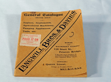
catalogue, Fraser & Jenkinson, Langwill Bros & Davies Pty Ltd, early 20th century
Langwill Bros & Davies of Melbourne were agents for imported farm pump engines, windmills and other farm implements.. Because of war shortages, they started building the engines themselves under the Challenge brand in 1916. "..with the exception of the magneto, every part of the engine is manufactured in Australia from Australian raw material." They also sold imported Challenge windmills.This item is associated with the history of agriculture in early Orbost and is a useful research tool.A small light brown covered catalogue which has "Langwill Bros. & Davies Pty Ltd" diagonally across front in black print, items on offer and details of the company. There is a white stamp on the front with red print - "If you're not interested in this; PASS IT ON; Please; It will be doing us a good turn".catalogue farm-machinery langwill-davies -
 Orbost & District Historical Society
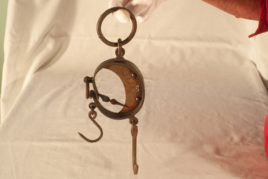
scales, late 19th - first half 20th century
William (Billie) Blackmore was born at or near Richmond, Victoria.At age 26 he joined the A.I.F. in WW1 while he was employed at Orbost as a labourer. He served in Egypt and France until following his discharge on December 20th 1916, he transferred to 15th Machine Coy in January 1917. He was severely wounded, repatriated to England until after an operation and further hospitalisation returned home to Orbost .In Orbost he did farm work for George and Elizabeth Trewin, eventually building a small shack on what was Rupert Leatham's property at Brodribb. He fossicked for gold in a nearby creek and the story goes that he buried his coins around the property. He donated these scales to the Orbost & Districet Historical Society. (more details and ref. John Phillips July 2016 Newsletter)This item is typical of those used by gold fossickers in the early 20th century. This object was likely to have been imported into Australia (possibly German) for use in Victoria,Small round hanging scales. At the top is a loop for hanging. There is a brass plate in the centre with measuring scale, in lbs, and needle pointer.scales instruments-weighing -
 Orbost & District Historical Society
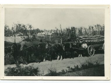
black and white photograph, late 19th century
This is a photograph of Dave Hawkless at Bete Bolong with a wagon load of maize from the farm of Sam Lynn. David Hawkless was married to Mary Downey in 1906. They had five children. This is a pictorial record of the transporting of maize in the Orbost district in the late 19th century. A black / white photograph of a man standing in front of a wagon loaded with sacks. There are six large horses tethered to the wagon. In the background are buildings. The wagon is standing on a gravel road.on back - "D. Hawkless M. Gilbert"hawkless-david maize-orbost transportation-agriculture wagon-horses -
 Ringwood and District Historical Society
Pamphlet, G.A. Green, Auction Sale Brochure - Garden Farms Estate, Ringwood, Victoria - 1919, 1919
Multi-fold brochure advertising public auction of one-acre, 2-acre, 5-acre and 8-acre allotments in Ringwood and Bayswater on Saturday 12th April, 1919. Brochure includes terms of sale, description of subdivision features and local facilities, and photographic images of the area.Subdivison includes Canterbury Road Heathmont, Armstrong Road Heathmont, Armstrong Road Bayswater, Bungalook Road Heathmont, Bungalook Road Bayswater, and Orchard Road Bayswater. Road shown as Bayswater Road to Bayswater became Mountain Highway Bayswater. Vendor: H.E.B.Armstrong, Auctioneers: Coghill & Haughton, 79 Swanston Street Melbourne, Telephone Central 2793, in conjunction with J.B. McAlpin, Ringwood, Opposite Station, Telephone Ringwood 7. (Map) Woodcock & McCormack, Civil Engineers Architects & Surveyors, 430 Little Collins Street, Melbourne, Phone 3241 Central. MOST OF THE MONEY COMES OUT OF THE LAND. And more money can be obtained from anb acre of fruit than from an acre of any other produce. But you do not have to grow fruit on Garden Farms Estate. You can go in for - Outer Suburban Home - Market Garden - Orchard - Pig Raising - Poultry Farm - Small Dairy Farm - Small Fruits - Floral Culture - Scent and Bee Farm - Or just for a Week-end Home. RINGWOOD - THE PLACE TO LIVE. The Beautiful Ringwood District has so many natural attractions, that half a Land Agent's work is done in just showing a prospective buyer round and about. Ringwood has a pull of its own that attracts folk, proved beyond doubt by its rapid development within the last decade (spite the war). First, it is high and healthy, picturesque and undulating, convenient of access, sufficiently close to the Metropolis for City and Business folk to live at Ringwood. Its development is solid, because most of its people are industrious husbandmen, real producers, who have turned idle hills into smiling gardens. These are the kind of real people to live amongst; ones who wear out their spades. The rapidly-developing town has excellent Stores, Trade and Repair Shops Churches, Banks, Telephone Exchange, Weekly General Market, Cool Stores, and good Private and State Schools, etc.; is Electrically lit, has Metropolitan Water Supply, and generally provides so that practically all shopping can be done locally. WHY RINGWOOD MUST GROW. Ringwood is a great centre and must be a greater. Two rapidly-developing railways junction here. The passengers from Ringwood Station cityward, in one year, number 250,000. Ringwood will be the terminus of the Outer Suburban Electric Eastern Railway. Its natural boundaries are the River Yarra on the North, Dandenong Creek on the South, the popular town of Croydon on the East, and the suburb of Mitcham on the West. This is a large territory that is steadily being converted from intense culture, and then it might be called (as regards its gardens) "The Devon Territory of Victoria." ARMSTRONG ROAD. This new road traverses Garden Farms Estate from its northern boundary on the main Canterbury Road, across Dandenong Creek, to its southern boundary on the main Bayswater Road, and will provide a long-desired additional link of communication between Bayswater and Ringwood. The 1-acre building sites on Bayswater Road are within 8 minutes' walk of the Bayswater Railway Station, and the Canterbury Road frontages are only 1-1/2 miles from Ringwood Station, and 1/2 mile from the Railway Station site of Canterbury Road; therefore, the whole Estate is easy of access and there should be a large demand for land so favourably placed. (Image) Cultivation Field - Potatoes on Lot 28 (Image) Picture of Bayswater Creek Flats. (Image) View from "Korumbeen" where Mr. Armstrong lived on Garden Farms Estate. Estate outlined in white ring. (Image) Site of New Bridge over Dandenong Creek. (Image) On one of the timbered lots adjoining railway. (Image) This Dandenong Creek traveres the Estate. (Image) Main Fern Tree Gully Line bisects the Estate. -
 Learmonth and District Historical Society Inc.
Photo, "Willow Vale" Waubra, Victoria, Late 19th Century or Early 20th Century
It show the farm "Willow Vale" Waubra that was once owned by the Christopher and Selina (nee Smith) Harrison family who once lived on this farm and whoes descendants continue to live in the same area today.A very pale sepia photo of the "Willow Vale" farm at Waubra, Victoria that was owned by Christopher and Selina (nee Smith) Harrison. It shows a horse and buggy, along with the main house/houses and out buildings with what look like it could be a slightly dry dam at the bottom of the photo.Nil -
Glen Eira Historical Society
Document - Box Family
This file contains two items pertaining to a property named Box Cottage (named after residents William and Elizabeth Box) located in Joyce Park, Jasper Road, Ormond 3204: 1/A typewritten document (two pages), the date and context unknown (albeit authored by A. Smith) about the property. The first part of the document describes the materials and techniques utilized during the property’s original construction around 1850 and during subsequent renovations, whilst the second part describes the reconstruction of the property at a nearby site by the City of Moorabbin Historical Society. 2. A printout of a page from the website of the City of Moorabbin Historical Society (authored by Yun Ma, last modified on 13/01/2013, and accessed 30/06/2014), about the property’s present usage as a museum. Included is some brief historical information about the property, plus advertising of some of the various artefacts on display therein. Also included are six black-and-white photographs (presumably hailing from the museum’s collection) portraying the property’s environs as they existed in the past.‘box cottage’, box family, box william, box elizabeth, cottages, smith a, a. lewis & co pty ltd timber merchants, building construction, construction materials, trees, city of moorabbin historical society, moorabbin historical society, ma yun, museums, museum displays, timber houses, joyce park, jasper road, ormond, timber, woodwork, woodworking, woodworking tools, farm and garden equipment, pioneers -
 Federation University Historical Collection
Photograph, Somerset Inn, Bannockburn
The Somerset Inn was built for Edward Carter Holmes by carpenter Isaac Sutherland and his two sons in 1855/1856. Situated on Bruce's Creek on the Shelford - Bannockburn Road. Bruce's Creek was the original name for current day Bannockburn. Black and white photograph of a house with slate roof and window shutters. The front fence is stone. The house is the former Somerset Inn (later a private residence). This building is located on the Leigh River at Bannockburn and was the home of Edward Carter and Sarah Holmes. Verso in blue ball point pen. "Somerset Inn on Leigh river Bannockburn. Home of Edward C. & Sarah Holmesholmes, leigh river, sarah holmes, ec holmes, holmes family collection, chatham-holmes family collection, edward carter holmes, farm, bannockburn -
 Federation University Historical Collection
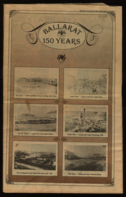
Newspaper, Ballarat 150 Years: Supplement to the Ballarat Courier, 1988, 17/03/1988
A supplement to celebrate 150 since the establishment of the Port Phillip Colony (Victoria).40 page newspaper published to celebrate the Sesquicentenary of Ballarat. Articles include: 1838-the pastoral period begins; First White Settlers arrive (Anderson, Winter, Yuille, Kirkland, Learmonth); Learmonths - Pioneer Settlers; The Rush to Ballarat; Last of the Aborigines; Eureka Affair Gains New Importance; Mining-After the rush; SMB - First Technical School; Clubs Play their Part; Ballarat Yuilles had Wealthy Ancestors; Town, Country Share a Close Relationship; Many Sides to Metals Industry; True Victorian City; Five Severe Recessions; Financiers to the Fore; Ready for War; City Rich in Sport Facilities; Visitors to most exciting place; No Place for a Nervous Lady; Theatres Provide Welcome Diversion for Mines; Might Achievers Among famous Citizens; Life Seemed Different After the War; Ballarat School of Mines Eastern Station Hotel; Memorial (Her Majesty's) Last of Many Theatres; Art Gallery at its Best; Pilgrimage to Yuille Cairn at Sebastopol Images include: Jelbart tractor; Sunshine Harvester; Bailey's Mansion; Pennyweight Hotel; Bridge Mall; Blue Riband Mine, Black Hill, Burrumbeet Shooting party; A wendouree rowing club; Motor Cycle Racing; Women bowlers, Queen Elizabeth; Gong Gong Methodist Church; Arbour day at Waterloo Farm, Smythes Rd; Gold panners (1890s); Ballarat Cricket Team (1902); William Peart; D'Angri's store; Sturt St Advertisements include: Rehfisch and Co.; UFS Dispensaries; Deutscher Mower Sales and Service; Haymes Paint; Cincotta's; Abraham's Sportscene; McK's; McKay Macleod; St John of God Hospital; Benjamins Real Estate; Ballarat Water Board; Cornell's Pharmacy; Laminex Industries; Coltman Mitre 10; Lal Lal Iron Mine; Heinz Bros; Crockers; Frank ford travel; S.J. Weir; Ludbrook Plumbing Service; Mars; Robert Sim Building Supplies, Frank Day; Sectrol Systems; Thornton Richardsballarat, anniversary, sydney abraham, cincotta, eureka, ballarat school of mines, mining, ballarat club, lal lal iron mine, ballarat rangers, victorian rifles, 3rd battalion victorian rifles, ballarat militia, white flat, celia scott, adelphi theatre, victoria theatre, montezuma theatre, charlie napier, juliamatthews, royal theatre, dick richards, henry sutton, eleanor lucus, martin hosking, newington estate, saleyards, g. gay & co, ballarat books, old benev' alleviated distress on goldfields -
 Flagstaff Hill Maritime Museum and Village
Document - Framed Poster, Borough of Warrnambool, Victoria, Australia, after 30/06/1875
This document, also referred to as a word picture or Tablet, is framed in glass and timber with gilt trim, is handwritten with colour highlights. The penned letters rest on ruled guide lines, decorated where the lines intersect. The writing gives a description of the state of Borough of Warrnambool around 1875; its location, the area it covers, its population, Harbour and facilities, public buildings and institutions, imports and exports, financial worth, number of houses, connection with other areas of the Colony. A possible reason and origin for the document is found in an article ‘Link with US Exhibition’ from the Warrnambool Standard of December 19, 1981, written by local historian Bruce Morris. The writer mentions that the Warrnambool Borough Council met on 15th June 1875 and recorded a letter from G.C. Levey , secretary to the Melbourne group of commissioners representing the Colony, and Victoria in particular, for the Philadelphia Centennial Exhibition of 1876. The letter asks Council to provide “statistics as to the population, social condition and commercial and industrial state of the district in and around Warrnambool.” A sub committee was formed for the project. The Mayor, Cr. Thomas King, wrote and signed a Report, presented to the council on July 14, 1875, in which “The Committee … begs to recommend that a Tablet be prepared setting for the particulars respecting the following matters relating to the Borough”. The matters included area, population, annual income, churches, schools, other public buildings, societies and companies, general description of houses erected, and returns of exports and imports for 1874. The minutes note that the Report was adopted. The article above also notes the opinion of Warrnambool printers who have examined the document; it is almost certainly to be an old lithograph, which means there could be several copies. It is possible that there may be a copy in Melbourne and another in Philadelphia. It is interesting to note that (1) the quoted location co-ordinates are for an “Unnamed Road, Packsaddle NSW 2880, Australia”, and that the DMS co-ordinates for Warrnambool’s Council Offices differ, being 38.23.9.12 South, 142.28.52.887. (2) the date for “Exports and Imports for the Year Ending 30th June 1875” is different to the period mentioned by Cr. King in the sub committee’s Report of recommendation “returns of exports and imports for 1874”. The information required to have the figures for the end of June 1875 would need to have been compiled very quickly for the Tablet to be ready for the opening of the Philadelphia Exhibition on 10 May 1876. The document/certificate shows the following – - - - - - - - - - - - - - - -- - - - - - - - - - - - - - -- - - - - - - - - - - - - - -- - - - - - - - - - - - - - - “Victoria Australia, Borough of Warrnambool. Latitude, 30.24.50 South, Longitude 142.32 East The Principal Port in the Western District of the Colony and the Centre of its Choicest Agricultural Lands. Established a Municipality in 1855, and Created a Borough 1863. Population in 1875 4,500. Warrnambool is the nearest Port to Melbourne on the Western Seaboard, being about 160 miles distant. Coaches run to and from the Metropolis daily, in connexion [connection] with the Railway of Geelong and Steamers belonging to Local Companies sail between Melbourne, Warrnambool, Belfast [renamed Port Fairy], and Portland several times weekly. The Harbour is known as Lady Bay, and is partially protected by a reef of rocks stretching from the mouth of the Hopkins River. The formation of a Breakwater has been decided upon by the Government, to extend 600 yards, at an estimated cost of £100,000. There are two substantial Jetties, one of 800 and the other of 600 feet in length. The former is connected with the Town by means of a Tramroad, along which Goods, inwards & outwards, are conveyed, & the latter has been constructed solely for the purpose of facilitating the transit of material for the formation of the Breakwater. In addition to the trade of the Borough and District, the principal Townships up country receive their supplies from Melbourne and ship their exports through Warrnambool. Potatoes form the staple produce of the district, and the richness of the soil can be estimated by the fact that the Government Statistics for 1875 give as the average yield a return of Seven Tons to the acre. Several thousand acres between Warrnambool and Tower Hill are now being laid down in Potatoes by Tenants who have leased the lands at rates up to £5 per acre for the season 1875-6. Wool, Tallow, hides &c are also largely exported, while the shipments of all descriptions of Farm Produce are annually increasing. Area of Borough, 3362 Acres. Net Annual Value £27,000. Annual Revenue £5,500. Number of Houses in Borough 800. Public Buildings and Institutions Churches. Church of England, Roman Catholic, Presbyterian, Wesleyan, Congregational and Baptist. Schools. Three State Schools, average attendance nearly 1000. New Building in course of erection. Several private establishments. Banks. Bank of Australasia, Bank of Victoria, National Bank, Colonial Bank and Savings Bank. Public Buildings. Court house, Custom house, Post & Telegraph Offices, Survey & Land Offices, Shire £, Town Hall, Mechanics Institute, Volunteer Orderly Room, Odd Fellows Hall, Hospital & Benevolent Asylum, Temperance Hall &c. Companies & Societies. Steam Navigation Co, Woolen Mill Co, Gas Co, Racing Club, Amateur Turf Club, Agricultural Society, Farmers’ Club, Cricket Club, Anglers’ Society, Building Society, Freemasons Odd Fellows, Foresters, Druids, Hibernians. Protestant Alliance, Rechabites, Sons of Temperance, &c, Fire Brigade &c. --- Exports and Imports for the Year Ending 30th June 1875 –-- --Exports Total Tonnage 27,800 (Calculated at the Current Warrnambool Market Prices) Potatoes Wool Wheat Barley Hides Skins Fowls Butter Cheese Eggs Tallow Leather Ale Pigs Sheep Sundries --Imports 13,000 Tons Of the Estimated Value of £520,000 Total Tonnage of Exports and Imports 40m900 Tons, Value £806,627 Passenger Travels, to ad from Warrnambool during year, 10,000 persons Revenue from all sources paid through Warrnambool Sub Treasury From 1860 to June 1875 £1, 292, 300 Thomas King [signed] Mayor Henry T Read [signed] Town Clerk” - - - - - - - - - - - - - - -- - - - - - - - - - - - - - -- - - - - - - - - - - - - - -- - - - - - - - - - - - - - - The document is of historical, social, economic and local significance in that it summarises activities, business, community, trade, travel and government at a point in time in Warrnambool’s history – 30th June 1875.Document, also referred to as a ‘word picture’ or ‘tablet’. Document is framed in glass and timber with gilt trim, handwritten with colour highlights. The penned letters rest on ruled guide lines, decorated where the lines intersect. Document outlines the establishment of Warrnambool as a Municipality in 1855 and Borough in 1863, with a population of 4,500 in 1875. It states geographic location, public buildings and institutions, harbor facilities and imports and exports for the year ending 30th June 1875. Two signatures "Thomas King" Mayor and "Henry T Read" Town Clerk. It shows the Coat of Arms of the Borough of Warrnambool.Signatures - "Thomas King" Mayor and "Henry T Read" Town Clerk. Warrnambool Coat of Arms; “British Coat of Arms, above sailing vessel and sheaf of wheat in sun, motto “By these we flourish” and around circumference “Borough of Warrnambool 1855”flagstaff hill, warrnambool, shipwrecked coast, flagstaff hill maritime museum, maritime museum, shipwreck coast, flagstaff hill maritime village, great ocean road, borough of warrnambool, municipality of warrnambool, document borough of warrnambool 1875, word picture of warrnambool 1875, tablet of borough of warrnambool 1875, statistics borough of warrnambool 1875, lithograph borough of warrnambool 1875, coat of arms warrnambool, warrnambool city motto – in these we flourish, establishment of warrnambool, warrnambool history, thomas king mayor of warrnambool, henry t read town clerk of warrnambool, warrnambool breakwater, warrnambool jetty, warrnambool imports and exports 1875, warrnambool agriculture 1875, warrnambool business 1875, warrnambool population 1875, centennial exhibition philadelphia 1876, framed certificate -
 Federation University Historical Collection
Photograph - Photograph and Documents, Anne Beggs Sunter, Latta/Downing Family, Mount Helen
The Federation University Mt Helen Campus was once the farm of John Latta and his wife Elizabeth Ann Dean. The couple married in 1867 and had three children at the time of John Latta's death (Elizabeth Ann b.1870; Mary b.1873; John b.1875). Elizabeth later married George Downing, and had another six children. The house was situated in the vicinity of the current Administration and Caro Conference Centre buildings, surrounded by an orchard, and a well under the current Albert Coates Building (Union Building). The land was purchased by the Ballarat School of Mines for their tertiary division from the Stapleton family.Various items relating to the Federation University Mount Helen Campus, and the early settlers on the land, the Latta Family. .1) Parish Plan, including E. Latta, M. Fiscalini, R. Wynne, R. Nixon, J.U. Smith, J. Davis .2) Part of a 1930s ordinance map showing Ballarat, Buninyong and Greenhill .3) Contour Map with the first two Mt Helen Campus buildings included. .4) Drawing a a proposed campus plan .5) Latta Family negativemount helen campus, latta family, greenhill, e. latta, m. fiscalini, r. wynne, r. nixon, j.u. smith, j. davis, parish plan, john latta, elizabeth latta, george downing, elezabeth downing, green hill, pontresina, abraham baxter, g. dean, market gardens, jim downing, bob thornton, j. hateley, martin fanning, toll keeper, anne beggs sunter -
 Federation University Historical Collection
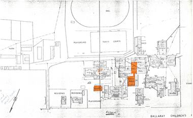
Plan, Plan of the Ballarat Children's Home
Copy of a plan of the Ballarat Children's Home (formerly Ballarat Orphanage) in Victoria Street. The plan names each building, and identifies the oval, tennis courts, playground and farm. The hall, dining room and school have been highlighted in orange. The 'Blue Birds' building has an orange question mark over it. WGS 84 37degrees 33' 35" S 143 degrees 53' 10" EWritten in blue "Board meeting next Wed"ballarat children's home, ballarat orphanage, orphanage farm, farrel cottage, swimming pool, gym, leach building, school, infant school, junior's wing, administration, laundry, blue birds, superintendent's residence, assistant superintendent's residence -
 City of Moorabbin Historical Society (Operating the Box Cottage Museum)
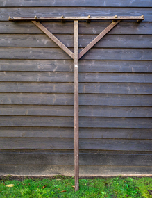
Farm Equipment, Rake, large Hay c1900, c1900
A hay rake is an agricultural rake used to collect cut hay or straw into windrows for later collection (e.g. by a baler or a loader wagon). It is also designed to fluff up the hay and turn it over so that it may dry. The next day it is spread again, so that the hay dries more quickly. Early settlers established productive market gardens, poultry,. pig and dairy farms , orchards and vineyards on the land in the 'Henry Dendy Special Survey Brighton 1841' - now Ormond, Bentleigh, East Bentleigh, Brighton, This hay rake is typical of the type used by early settlers in Moorabbin Shire c1900Large wooden Hay rake , hand made c1900farm equipment, hay rakes, hammers, early settlers, market gardeners, blacksmiths, tools, building equipment, moorabbin shire, bentleigh, mckinnon, highett, cheltenham,ormond -
 City of Moorabbin Historical Society (Operating the Box Cottage Museum)
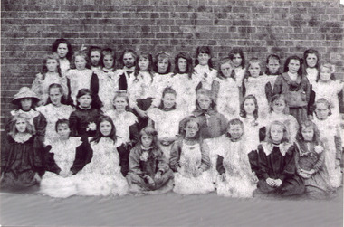
Photograph - Black & White East Bentleigh State School No 2083 c1900
Early settlers established market gardens, farms and business in the East Brighton ( East Bentleigh) area of Henry Dendy's Special Survey 1841 Brighton. The small communities established Churches and Schools. The Church of England opened St Stephen's Common School c 1850 in Tucker Road with 26 pupils. When the Government School opened 1878 the pupils were transferred to the new Centre Road building and it served the developing East Bentleigh Community until 1990. East Bentleigh State School no. 2083, Centre Road 1878 was closed c1990 due to the dwindling number of pupils enrolling following development of Valkstone SS East Bentleigh, Ormond East SS ( now McKinnon SS) and Tucker Road SS East Bentleigh Names of Pupils inscribed on back of original photograph show the children of the early settler families in Moorabbin Shire Back Row -Bessie long, Ruby Marriott, Irene Peterson, Jessie Gebuer, Grace Reid, Ella Marriott, Daisy Arnold, Lucy Hosking 2nd standing - Edie Roberts, Daisy Marriott, Elsie Strack, Ida Gouruly, Ephanie Bruce, Emma Thompson, Evelyn Marriott, Sarah Jackson, Lola G. 3rd kneeling - Lily Moore, Lizzie Sharman, Mag. Scotland, Em Ray, Elsie Claydon, Lily Marriott, ?? Day, ,Bessie Brewster, Eva Lindberg Front- Florrie D......ieson, Florrie ...i....ade, Ruth Goodrich, Lily Boles, Ettie Arnold, Bessie Marriott, Amie Jackson, Eileen Hosking The Government School opened 1878 in the new Centre Road building near Tucker Road, and it served the developing East Bentleigh Community until 1990. East Bentleigh State School no. 2083, Centre Road 1878 was closed c1990 due to dwindling number of pupils following development of Valkstone SS East Bentleigh, Ormond East SS ( now McKinnon SS) and Tucker Road SS East Bentleigh all situated along or near Tucker Road. Black & White photograph, reproduced c2005., of girl pupils at East Bentleigh State School 2083 c 1900east bentleigh state school no.2083c1900, marriott john, box jessie, pederson vic, long bessie, wong george, shephard hilda, mcneil annie, smith j l; smith mary ann, stanley helen, smith vic, smith harry redvers, chaff cutter, horse drawn carts, toll gates brighton, motor cars 1900, steam engines, early settlers, bentleigh, mckinnon, parish of moorabbin, city of moorabbin, county of bourke, moorabbin roads board, shire of moorabbin, henry dendy's special survey 1841, were j.b.; bent thomas, o'shannassy john, king richard, charman stephen, highett william, ormond francis, maynard dennis, market gardeners, vineyards, orchards -
 City of Moorabbin Historical Society (Operating the Box Cottage Museum)
Photographs, 7 x B&W Circa 1918 Cheltenham Methodist Youth Group, Circa 1918 Photos of Cheltenham Methodist Youth Group, 1918
Circa 1918: Various Photos of the Cheltenham Methodist Youth Group. Row 1 and 2: "At Flinders". Row 3: 1st Left, "Holidaying at Cockatoo". in 1852 Stephen Charman, who had arrived in Melbourne 1842 aged 21 years as one of Henry Dendy's emigrants, purchased 160 acres in Spring Grove ( now Cheltenham). Stephen and his family lived in a wattle and daub hut and worked hard to establish a market garden, poultry and pig farm. The first Methodist Church Services were held at their home. In 1855 Stephen gave 1 acre of his land on Balcombe Road to the Methodist Church for a School, Burial ground and a Chapel which was built in 1857.The Methodist Church, Balcombe Road was the 2nd religious building to be erected in Spring Grove now known as Cheltenham c 18577 small black and white photographs of the Cheltenham Methodist Youth Group at Flinders, Cockatoo and unkown locations, c 1918 . First 3 photos are of male cyclists on a trip to Flinders, Victoria. Photo 4 shows 6 ladies and a man on holiday at Cockatoo in the Dandenong Ranges ,Victoria . Photos 5 to 7 show men, women and children in bushland surroundings of unrecorded locations.Photo 1 - 3 on back : Flinders 1918 Photo 4 left on back : Holiday at Cockatoo right on back : Whitehead Photo 5-7 nilcheltenham, cheltenham methodist youth group, 1914, 1918, charman stephen, gettens mary, spring grove, methodist church, charman road, balcombe road, dendy henry, henry dendy's special survey 1841, youth groups, social groups, market gardners, early settlers, pioneers, dairy farmers, poultry farmers, pig farmers,moorabbin, brighton, -
 City of Moorabbin Historical Society (Operating the Box Cottage Museum)
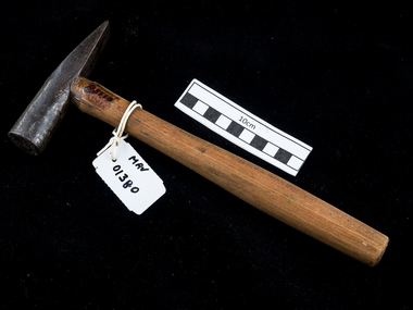
Tool - Hammer, wood metal taper head, c1900
Among the early settlers in Moorabbin Shire were blacksmiths who made tools for the other settlers who were establishing the homes, market gardens, farms, orchards and various businesses. Early settlers were self reliant and repaired their own equipment for kitchen,dairy, farm, horses, carts using various tools . This hammer is typical of the type used by early settlers in Moorabbin Shire c1900c1900 Hammer with a wooden handle and metal head. The metal head a circular striking edge and a tapered wedge shaped edgehammers, early settlers, market gardeners, blacksmiths, tools, building equipment, moorabbin shire, bentleigh, mckinnon, highett, cheltenham,mcewan james pty ltd, melbourne, bunnings pty ltd,