Showing 16227 items matching " area"
-
 National Vietnam Veterans Museum (NVVM)
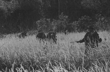
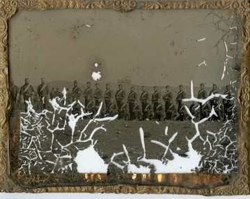
Photograph, Gibbons, Denis, Patrolling Suspected VC Area
Denis Gibbons (1937 – 2011) Trained with the Australian Army, before travelling to Vietnam in January 1966, Denis stayed with the 1st Australian Task Force in Nui Dat working as a photographer. For almost five years Gibbons toured with nine Australian infantry battalions, posting compelling war images from within many combat zones before being flown out in late November 1970 after sustaining injuries. The images held within the National Vietnam Veterans Museum make up the Gibbons Collection. A black and white photograph of some D Company, Headquarters Personnel 6 RAR/NZ(ANZAC), patrolling toward a suspected VC area during Operation Lavarack (June 1969). Left to right L/Cpl D.S Devantier, L/Cpl J Gostynski, Lt G R Spencer, Maj I T Stewart and Gnr G K Grantphotograph, d coy, 6 rar/nz, operation lavarack, vc, gibbons collection catalogue, l/cpl d.s devantier, l/cpl j gostynski, lt g r spencer, maj i t stewart, gnr g k grant, 6 rar/nz (anzac), viet cong, denis gibbons -
 Greensborough Historical Society
Folder, Investors in the Grace Park area - Fricker Brothers 1957, 2018_05
Collection of records regarding the acquisition of land by the Fricker brothers in the Grace Park area of Greensborough, and their sub-division and sale between 1957 and 1975. Researched and edited by Peter Simmenauer Folder containing Certificates of Title, photocopies of Death Certificate and Probate documents, list of land sales and historical notes, researched and edited by Peter Simmenauer grace park, fricker avenue greensborough, desmond court greensborough, desmond fricker -
 Kiewa Valley Historical Society
Sheet 1 - nine small black and white photos. Sheet 2 - eight small black and white photographs, c 1948 and early 1950's
These photos are a pictorial and historical record of the early construction days of the Kiewa Scheme and a personal record of the photographer, Ronald George Thorn, of his days as an engineer with the SECV. He worked in the Kiewa area as a cadet engineer from 1948 to 1950 and then in 1953 - 56 as an electrical engineer grade 2.These photographs tell the story of one man's involvement in the construction of the Kiewa hydro electric scheme during his employment with the SECV.A foolscap sized sheet of light weight cardboard with nine small black and white photographs pasted on side 1 and eight same sized black and white photographs pasted onto side 2. The number 1 is handwritten in ink on a small square of white paper and adhered to the top of the sheet. On the other side of the sheet is number 2, handwritten in ink on white paper and adhered to the top of the sheet with sticky tape. secv, engineer, kiewa -
 Stawell Historical Society Inc
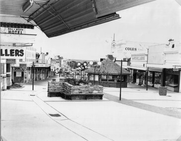
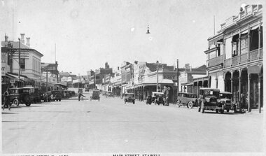
Photograph, Main Street looking West from Fountain Area down Gold Reef Mall c1984
Main Street looking West from Fountain Area down Gold Reef Mall Shows Rotunda and planter boxes. Bull and Mouth Hotel at left of photo Geo Mitchell at right. C1984stawell businesses, streetscape -
 Stawell Historical Society Inc
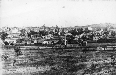
Photograph, Town & Big Hill from King Street area c1900
Town & Big Hill from King Street area. c1900 Market Building in Skene Street visible in left of photo. St Patrick's Church on Right. Rail line and signal pole in foreground of photo across image.stawell, streetscape, panorama -
 Stawell Historical Society Inc
Photograph, Main Street Stawell looking East from area in front of Town Hall -- Postcard c1930
Valentine Series No 1078 Main Street looking East from area in front of Town Hall c1930 Town Hall Hotel Post Office and Post Office Hotel and Bull and Mouth Hotel are visible. Vehicles in street.Valentine Series No. 1078 Main Street Stawellstawell business streetscape -
 Stawell Historical Society Inc
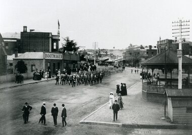
Photograph, Bandsmen leading Senior and Junior Cadets in Main Street Stawell looking East from Memorial Area 1908
Parade of Bandsmen leading Senior and Junior Cadets in Main Street looking East from Memorial Area 1908. Boot makers shop between Town hall and Anglican Church on left Town Hall Hotel and shops on right with band rotunda to right of photo.stawell band pavillion boer war streetscape -
 Ringwood and District Historical Society
Map - State Aerial Survey, Dandenong Ranges Area Sheet 7, Parishes of Warrandyte, Scoresby, Ringwood and Nunawading - 1956
Map of central and southern areas of Ringwood and part of Ringwood East and Heathmont compiled by Dept of Lands and Survey, July 1956, from aerial photographs and Cadastral Survey information. Subsequent coloured hand-drawn additions showing layout of a number of post-NSW Separation era proposed subdivisions that did not eventuate, including Village of Studley Estate, Township of East Kew Estate, Township of Ballyduffy Estate, Township of New Flemington Estate, Township of East Hawthorne Estate. Ringwood A4B2, 849 A4B Zone 7. Scale: 10 chains to 1 inch. Contour interval 20 feet. -
 Stawell Historical Society Inc
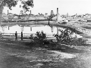
Photograph, The Pleasant Creek Cross Reef No1 Shaft Panorama of a Mining Scene in the Duke Sands area c1875
Mining Scene Duke Sands area c1875 Behind the tree on left is Extended Cross Mine and on the right is the Oriental Mine. In the centre is the North Cross Mine No1 shaft. In the foreground is one of the Moonlight dams. St Peters Lutheran Church in Scallan Street can be seen on the right horizon. Two mines and workings on other side of Moonies settling dam. Two Gentlemen lower left cornerstawell mining -
 Kiewa Valley Historical Society
Maps - Bogong x2, Tawonga, Omeo, Dargo, Victoria and others, 1. Bogong Alpine Area; 2. Bogong 8324; 3. Tawonga Topographical; 4. Omeo 8433; 5. Dargo 8323; 6. Victoria State
1. Bogong Alpine Area (outdoor Leisure Map. survey & Mapping Victoria, Government of Victoria, Edition 2, reprinted 1991 with an image of Mt. Feathertop on the front. Information for tourist in the Alpine National Park: Bogong Area. Including: recreational activities, history, weather and vegetation and a list of walks together with locality maps and photographs. The front cover has an image of Mt Feathertop against a blue sky with yellow writing 'Bogong Alpine Area', there is a yellow triangular block on the right hand top corner with black writing 'Outdoor Leisure Map. On the bottom edge is a block of yellow with black writing 'Survey & Mapping Victoria' and a light green map of Victoria with 'VICMSP' printed in white. 2. 8324 Bogong Victoria, Edition 1, Commonwealth of Australia 1981. A topographical Map: 1:100,000 scale (1 cm to 1 KM). Map has a red cover with white writing together with a white block and black writing and a map insert. 3. Tawonga Topographical Map - Forests Commission Victoria, / revised 5/9/77, DEG No. 68-G/399. A Tawonga 803 folded map in a beige colour with the back blank. 4. Omeo 8433 Victoria, Edition 1, Department of Natural Resources. The map has a red and white cover with black writing and a simple map of Australia at the bottom. 5. 8323 Dargo, Edition 1, Commonwealth of Australia. A red and white cover with a map insert. 6. Victoria State Map, Hema Maps, 2002. Hema Maps, State Map, colourful cover with a map of Australia and four tourism photographs. Scale 1: 850,000 An inscription handwritten in blue pen "Trappers Gap to Mitta Mitta 1" to 1 mile". There are some pen markings and notations of tracks.maps, bogong, omeo, tawonga, dargo, victoria, bogong alpine area -
 Ballarat Tramway Museum
Document, Hector Bell Junior, "Street passenger transport system of Geelong Urban Area", 1949
Report by Hector H Bell Junior of the MMTB early 1949, titled "Street passenger transport system of Geelong Urban Area". Looks at the history of public transport in Geelong, tramway data, financial analysis, the Geelong bus system, buses servicing the North Shore industries - principally the Ford Works, the condition of the bus fleet, taxi and private car hire services, functions of a street transport authority, town planning, populations and traffic surveys, relative values of passenger vehicles, trolley buses, industry and recommendations. Said the tramway system was obsolete, should be a rail service between North and South Geelong, set up a street transport body, replan the Geelong railway station, additional roads to service the North Shore area. Refers to attachments. Has a list of people involved in the preparation of the report. See item 112 for the AETA response of April 1949 to this report.Yields information about the Geelong tram and bus services in 1948/49 and how it could be developed or reformed. Has a close association with Hector Bell Junior, the son of the then MMTB Chairman.Document - 18 foolscap sheets photocopied and stapled in three places along the side.tramways, secv, geelong, statistics, history, passenger services, reports, aeta -
 Greensborough Historical Society
Photograph - Digital image, Marilyn Smith et al, Janefield Precinct: Looking toward grave area from camp, 27/11/2014
Janefield Precinct: Looking toward grave area from camp. The remains of this site are between Greensborough and Janefield. A RAAF Hygiene Training Camp was located on the Plenty River, just south of the Janefield community. It was in use from 1944 to 1946. The Camp was constructed from salvaged materials. Instruction included building and maintenance of grease traps, latrines, elementary plumbing and carpentry.Early remains of a WW2 training camp Digital colour photograph. -
 Puffing Billy Railway
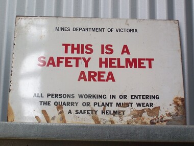
Sign - Safety Helmet Area
Sign - Safety Helmet Area, Mines Dept. of VictoriaHistoric - Safety Sign used by Mines Dept. of Victoriametal sign - Sign - Safety Helmet Area Mines Department of Victoria This is a Safety Helmet Area All persons working in or Entering The Quarry or Plant must wear A Safety Helmetpuffing billy, sign - safety helmet area,, mines dept. of victoria -
 Melbourne Tram Museum
Document - Report, Melbourne & Metropolitan Tramways Board (MMTB), "Schedule of Motor Omnibus Routes Metropolitan Area, 1/08/1930 12:00:00 AM
Set of 9 typed full foolscap sheets, stapled on the left hand side with a blue cover strip titled "Schedule of Motor Omnibus Routes prescribed within the Metropolitan Area for the Period 1st January 1930 to 31st December 1930". Dated by hand in the top right hand corner "1.8.30". Lists the route number, route, sections, service (frequency), fares, bus number authorised and actually licensed. Does not list the operator. For full pdf of file see i2.pdf See also Reg Item 2682 for a similar 1938 listing.trams, tramways, regulations, mmtb, tramways, buses -
 Greensborough Historical Society
Photograph - Digital Image, Anne Paul, Opening of restored Old Lower Plenty Bridge 2001 - area adjacent, 14/03/2001
The opening of the restored Old Lower Plenty Bridge, opened on 14/03/2001 by the Minister for Environment and Conservation Sherryl Garbutt MLA and Mayor of Banyule Cr Dale Peters. The project was jointly funded by Banyule Council and Parks Victoria. The restored bridge is the oldest remaining bridge in Nillumbik and forms part of the Plenty River Trail. this photograph shows the area adjacent to the bridge on the day of the opening.Digital copy of colour photographlower plenty, lower plenty bridge, sherryl garbutt, dale peters, banyule council, parks victoria -
Whitehorse Historical Society Inc.
Article, Fourth zone added to flats control, 1969
A report on a decision adopted at a Council meeting to divide the municipality into four areas for planning purposes.A report on a decision adopted at a Council meeting to divide the municipality into four areas for planning purposes.A report on a decision adopted at a Council meeting to divide the municipality into four areas for planning purposes.residential development, city of nunawading, town planning -
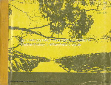 Eltham District Historical Society Inc
Book, Land Conservation Council, Report on the Melbourne Study Area, December 1973
This report is one of a series describings the physical nature of the land and its environment, examines the likely forms of land use, and assesses the hazards associated with these uses. It is divided into four main sections: Introduction, Characteristics of environment, main forms of land use and description of 24 specific blocks in the study area which include Torquay, Brisbane Ranges, Werribee, Wombat, Loddon, Romsey, Puckapunyal, Strathbogie, Eildon, Disappointment, Break O'Day, Black Range, Cerberean, Upper Goulburn, Kinglake, Donna Buang, Upper Yarra, Thomson, Dandenongs, Bunyip-Latrobe, Shady Creek, Tyers, Westernport and Strzelecki. The Land Conservation Act 1970 established the Land Conservation Council whose functions is to "carry out investigations and make recommendations to the Minister with respect to the use of public land in order to provide for the balanced use of land in Victoria. This report sets out to describe and assess the natural resources of the public lands in the Melbourne area and provides a factual basis on which members of the community may base submissions to the [Land Conservation] Council of Victoria.444 pagesnon-fictionThis report is one of a series describings the physical nature of the land and its environment, examines the likely forms of land use, and assesses the hazards associated with these uses. It is divided into four main sections: Introduction, Characteristics of environment, main forms of land use and description of 24 specific blocks in the study area which include Torquay, Brisbane Ranges, Werribee, Wombat, Loddon, Romsey, Puckapunyal, Strathbogie, Eildon, Disappointment, Break O'Day, Black Range, Cerberean, Upper Goulburn, Kinglake, Donna Buang, Upper Yarra, Thomson, Dandenongs, Bunyip-Latrobe, Shady Creek, Tyers, Westernport and Strzelecki. The Land Conservation Act 1970 established the Land Conservation Council whose functions is to "carry out investigations and make recommendations to the Minister with respect to the use of public land in order to provide for the balanced use of land in Victoria. This report sets out to describe and assess the natural resources of the public lands in the Melbourne area and provides a factual basis on which members of the community may base submissions to the [Land Conservation] Council of Victoria.land use, kinglake, thomson valley, conservation, public lands -
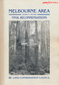 Eltham District Historical Society Inc
Book, Land Conservation Council, Melbourne Area, District 2 Review: Final Recommendations, 1994
Notices showing the boundary of the area of the review and advising that an investigation was to be carried out were published in the Victoria Government Gazette and in local and other Victorian newspapers in May 1987. A descriptive resources report was published in August 1991. Council received 1,425 submissions and letters following publication of the descriptive report. The Council considered these submissions and published proposed recommendations in April 1993. A further 1,993 submissions were received in response to the proposed recommendations. The Council published its final recommendations in July 1994. A change to legislation in 1989 enabled the LCC to make recommendations for public land within a ‘town’, though cities and rural cities remained excluded from the definition of public land. Timber resources and water quality and yield from timbered catchment areas remained significant issues in Melbourne’s catchments. Recommendations for the Yarra Ranges National Park were based around the closed Melbourne water catchments and adjoining state forest. A recommended Phillip Island State Park based around the penguin reserve was ultimately implemented as the Phillip Island Nature Park.Shire of Nillumbik DPE/Enviro -
Melbourne Tram Museum
Newspaper, The Age, "Tram drivers say end of 86 route a dangerous area", 19-1-2019 to 13/5/2019
Newspaper clippings from The Age titled: "Tram drivers say end of 86 route a dangerous area" - 19-1-2019 "Public transport sex attacks surge" - 26-1-2019 "Sex attacks on trains trams surge" - 26-1-2019 "Transgender fears over tram train travel" - 4-2-2019 "I was groped on the tram - not for the first time" - 15-2-2019 "Woman followed off tram assaulted" - 13/5/2019 Series of article about safety of travelling on public transport following the murder of Aiia Maasarwe on the Bundoora tram Jan. 2019.trams, tramways, public transport, route 86, behaviour, bundoora, police, safety -
Ringwood and District Historical Society
Family History, Eva McLaren (now Moore), Single page dated 11 March 2003 - typed notes on the McLaren family having lived in the Bedford Road area of Ringwood from April 1927, 11-Mar-03
Single page of typed notes on the McLaren family having lived in the Bedford Road area of Ringwood from April 1927, headed "On The Street Where You Live" prepared by Eva McLaren (now Moore), dated 11 March 2003. +Additional Keywords: McLaren, Eva / McLaren, Rev Gilbert / McLaren, Dorothy / Wigley, Linda / Wigley, Evan / Wigley, Ralph / Wigley, Eslie / Wigley, Amy / Wigley, Bernard / Wigley, Ray / Lobascher, Joe / Lobascher, Mary / Evans, Fay / Evans, Mr and Mrs / Woollacott, Eveline / Woollacott, May / Mannix, Dr / Tasker Family / Paddock, Miss / Watson, Clarice / Watson, Bert / Watson, Vera / Swan, Alix -
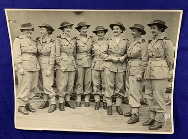 Returned Nurses RSL Sub-branch
Photograph - Photograph on photo paper, Jacquinot Bay Area, New Britain, [Circa 1940s]
Event photography, first Australian Army Nurses to arrive in New Britain.Unframed, printed black and white photograph on photo paper of 8 women in uniform standing in a row, from left to right Sisters Jean Gracey, Marjorie Smith, Kathleen Barnes, Gertrude Muller, Mary Wilson, Marie O'Laughlan, Dorothea Harrison and Gwen Dwyer. "DEPT. OF INFORMATION" [Stamped in purple in on back] "Jacquinot Bay Area, New Britain... 253. The first Australian Army Nurses to arrive in New Britain. Leading from left to right: Sisters Jean Gracey (Nutgrove, Q'sland) Marjorie Smith (Roseville, Sydney) Kathleen Barnes (Nedlands, W.A.) Gertrude Muller (Harrisville, Q'sland) Mary Wilson (Caulfield, Vic.) Marie O'Laughlan (Wangaratta, Vic.) Dorothea Harrison (Beaudesert, Q'sland) and Gwen Dwyer (Kew, Vic.). AUSTRALIAN OFFICIAL PHOTO. PASSED BY PUBLICITY CENSORSHIP 8/3/45. " [Typed in blue/purple ink on paper which has been stuck on the back of the photo]pacific war, jean gracey, marjorie smith, kathleen barnes, gertrude muller, mary wilson, marie o'laughlan, dorothea harrison, gwen dwyer -
 Ringwood and District Historical Society
Map - State Aerial Survey, Dandenong Ranges Area, Parishes of Warrandyte and Ringwood - 1956
Map of central and southern areas of Ringwood and part of Ringwood East and Heathmont compiled by Dept of Lands and Survey, July 1956, from aerial photographs and Cadastral Survey information. Subsequent hand-drawn addition of streets showing layout of "Township of Ballyduffy Estate 1858-60", an earlier proposed subdivision that did not eventuate. (See attached 5009b Ballyshanassy_ Melbourne’s lost suburb.pdf for Ballyduffy historical naming relevance). Ballyduffy Estate streets include City Road, West Prussia Road, Duffy Street, Ireland Street, Evans Street, Victoria Street, Regina Street, Short Road, Prussia Road, Duffy Street East, Ireland Street East, Evans Street East, Chapman Street. Misc Topo 93 Sheet 22, Ringwood A4B2. Scale: 4 chains to 1 inch. Contour interval 20 feet. -
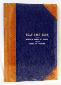 Orbost & District Historical Society
cash book, first half 20th century
This ledger was used by the Shire of Orbost to record transactions relating bto the Newmerella Drainage Area from 1927 to 1950. The item was donated to Orbost & District Historical society from P.R.O.V. as a Place of Deposit (POD) item for safe keeping by a local history group or museum. The shire covered an area of 9,347 square kilometres and existed from 1892 until 1994 when it became part of the East Gippsland Shire Council. Orbost was at first included in the Bairnsdale Shire from 1882 and was later part of the Tambo Shire. Because of travelling distances the Croajingalong Shire was created in 1892 (name changed to Orbost Shire 17.2.1893 with James Cameron as the first Shire President. In 1994 it amalgamated to become part of East Gippsland Shire Council.This item is a hand-written record of the accounts of the Orbost Shire local government. It pre-dates computer records. The Orbost Shire Council no longer exists having been absorbed into the East Gippsland Shire Council. A ledger with a black cover and brown binding. It has marbled end covers. It contains handwritten records of transactions relating to the Newmerella Drainage Area. On the front cover in gold print is "LOAN CASH BOOK (underlined) NEWMERELLA DRAINAGE AREA ACCOUNT (underlined) SHIRE OF ORBOST". on spine - "Newmerella Drainage Area Cash Book" in gold print.orbost-shire-council ledger accounts newmerella-drainage-area -
 Flagstaff Hill Maritime Museum and Village
Photograph - Glass plate, circa 1866
This glass plate photograph shows good detail of members of the Warrnambool Garrison posing for their photograph in front of a young township. There are other well-dressed citizens behind them. The three men with frogging on their sleeves were commanders were likely to be commanders. The men are facing north with Cannon Hill and the fortification area in the background. It dates from the 1860s. The firearms held appear to be 1853 pattern Lee Enfield muskets used by the British army in Crimea at this time and in Australia, rather than the later Martini Henry cartridge rifles. The uniforms match other photos of the Warrnambool Garrison Militia and Band in our Collection, taken up until the 1880s. The three storey building in the photograph is likely to be the Manifold & Bostock flour mill, built in 1854 near the ‘cutting’ in Merri Street, which was one of the main streets at the time; if one faced the building’s front from a vantage point and looked south to south-east, the hills around Flagstaff Hill and Cannon Hill would be behind that mill, and the Harbour behind the hills. This is the area of the Fortifications. The glass plate method of photography was widely used during the mid-19th to early-20th century. The donor and maker of the photograph are unknown. Around this time the citizens of Victoria were prospering from the gold rush but felt isolated and uneasy about their security in the colony. In 1854 the Volunteer Act was passed to provide some military defence. In 1858 the Warrnambool Volunteer Rifle Corps was established, disbanded in 1863, then a new Warrnambool Detachment was formed in September 1866. Legislation was passed in 1884 that replaced the volunteers’ corps with a partly paid, permanent Militia Defence Force. The batteries manning the coastal forts of Victoria were termed Garrison Artillery Companies. When the Army was federated in 1901 there were eight Militia Companies in Victoria. Warrnambool and Port Fairy together were known as 8 Coy AGA (Australian Garrison Artillery). Changes to formation and name continued into the 20th century.This photograph is a record of the very early local defence force, circa 1866. The photograph signifies the connection of the colony in Victoria to the growing need for security due to the unrest in Europe at that time. The photograph is also locally significant to the industry of the young township of Warrnambool, showing what is likely to be one of the first flour mills in the town. The photograph is also the only example of the early methods of glass plate photography in our collection. Photograph, rectangular glass plate, positive sepia image. Photograph has brass framed edges that fold over to the back, with mitred corners. The front edges are pressed with a decorative floral pattern. The photograph shows a group of thirty military men, standing or kneeling, in dark uniforms with pillbox forage caps, round-collared jackets with light buttons, light sashes worn from top left shoulder to bottom right side of waist belt, and long, straight-legged trousers. Three of these men have light braid around the buttons on the front of their jackets, light frogging on their sleeve cuffs and stripes on the outside seams of their trousers. The other twenty-seven men have plain uniforms and are holding firearms in their right hands, steadied with their left hands. Other figures are standing behind this group of soldiers, including three or four men wearing top hats, jackets and ties. In the background is a row of buildings. The central building is three stories high. Bare hills are in the far background. The foreground is uneven ground with patches of short grass. Photographer looking towards the south east and Cannon Hill, with the Warrnambool Garrison facing north, ca.1860s.flagstaff hill, warrnambool, shipwrecked coast, flagstaff hill maritime museum, maritime museum, shipwreck coast, flagstaff hill maritime village, great ocean road, glass plate, photography 19th century, colonial forces, military defence, volunteer act 1854, volunteer rifle, garrison artillery, volunteer corps, militia, militia garrison band, pillbox forage caps, helpmann, manifold and bostock, 1853 lee enfield musket, tintype, warrnambool garrison, 1860s, cannon hill, manifold & bostock, flour mill, 3-storey building -
 Ballarat Tramway Museum
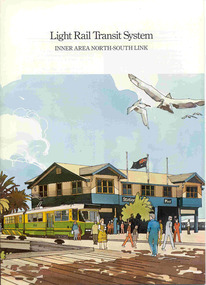
Book, Metropolitan Transit Authority (MTA), "Light Rail Transit System - Inner Area North-South Link", c1986
Sixteen page book, A4 portrait format, saddle stapled, titled "Light Rail Transit System - Inner Area North-South Link", published by the Metropolitan Transit Authority detailing the conversion of the former heavy electric suburban railway lines to St Kilda and Port Melbourne to electric trams or Light Rail. Has foreword by Tom Roper, Minister for Transport, Describes the proposed system, vehicles, development of articulated vehicles (2001, 2002), interchange with rail services, travel times and a map showing the proposed route, including a possible extension along Mitford St. and Broadway to Glenhuntly Road. Has a number of artists impressions of the vehicles at Station Pier and South Melbourne station. Includes colour photographs of the vehicles, conductors and photos of other light rail systems in Hanover and Amsterdam. Published c1986.trams, tramways, melbourne, light railways, mta, st kilda, port melbourne, articulated trams -
 Melbourne Tram Museum
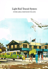
Pamphlet, Metropolitan Transit Authority (MTA), "Light Rail Transit System - Inner Area North - South Link", early 1987
Sixteen page, A4, full colour, printed on gloss paper, centre stapled pamphlet, titled "Light Rail Transit System - Inner Area North - South Link"", describing the proposal for the conversion of the St Kilda and Port Melbourne rail lines to light rail. Undated, Appears to be earlier than May 1987 (See Reg Item 457). Has a foreword by the Minister, Tom Roper, explains the system, shows high platform stops using the Hanover example, development of the project, journey times, costs and saving and two page map of the system, showing a possible extension to Glenhuntly Road. Has the Met contact and logo on the rear. Covers have a perspective view at Port Melbourne Station Pier. See Also Reg Item 457 for a similar pamphlet. 2nd copy added 23-10-2016trams, tramways, minister for transport, metropolitan transit authority, st kilda, port melbourne, light rail -
 Stawell Historical Society Inc
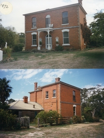
Photograph, Armstrong’s Area Houses c 1990's -- 2 Photos -- Coloured
Residence Fountainhead Brewery Armstrong's Est. c 1872. The rear view photograph shows a more recent renovated building. Some evidence of demolition to rear of building (servants stairs etc.) Following notes taken from information in album 9 - "Compare earlier photos and note balcony etc. Later views, This photo early 2003. Owing to timber decay balcony was removed for safety. Finances permitting complete balcony will be replaced. Twin columns and iron lace are not original. Early description mentions statues in "niches" beside door. Female statue left is original. White pedestal at left was male stature damaged by a falling tree. Both statues were fountains." Photographs taken by Mr. Don Richard and held in Album 9b Armstrong’s Area.Two coloured photographs, of a brick double story building. The front view of the building has 4 windows and 2 doors. Two white columns at the entrance with decorative iron work support the roof of the porch with 2 white chairs and a table on top. Either side of the entrance door are 2 white wall indents "niches" with pot plants. The second photo show the back view of the two story building with a single story building attached that has a tin roof. A timber fence with a gate shows the side entrance to the single story building. 648M NHNN 8H01HPRO3 WIMMERA 1MHGINGstawell -
 Eltham District Historical Society Inc
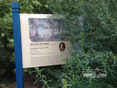
Photograph, Peter Pidgeon, Heidelberg Artists Trail signs are through this area including local artist Walter Withers, 2 Sep 2017
The Heidelberg School Artists Trail was established in about 1999 with about 52 signs across four local governemnt areas including Nillumbik and Banyule. This one located in Wingrove Park Eltham pays tribute to Walter Withers and his painting "The Silent Guns" Transcription of sign: Walter Withers – The Silent Gums, 1909 Walter Withers painted this tranquil pastoral scene in the vicinity this park. Here he has captured the dairy cattle belonging to local Eltham farmer, Mr. Tom Orr, feeding and resting in the shade of the tall Manna gums. Wither’s daughter, Nan recalled how her father, for inspiration, often visited the property of their neighbour, Mr. Tom Orr, and in his later years, Withers painted many landscapes depicting Mr Orr’s sheep and dairy cattle. Heritage Excursion by EDHS Members - An Eltham South Ramble, 2 Sep 2017Born Digitalactivities, eltham district historical society, eltham south, heritage excursion, local history centre, walter withers, heidelberg artists' trail, wingrove park trail, the silent gums -
 Ringwood and District Historical Society
Photograph, Landys home (formerly Patersons). Byways estate area (East Ringwood). 5 Views. (c1968)
SS0261 is the covering letter from Beth Little, dated 31/3/1969, which states: "Please fined enclosed the photographs I took of Landy's 80 yr. old home which was moved just before last Christmas to another site on their estate...it was built by some people by the name of Patterson and originally included the Byways Estate and other land which extended up to about Lillis Crt. The land known as Byways Estate was sold off to a Mr Best by a later owner so far as I can find out.." Written on back of photographs: SS0261a:From about where the feed shed was. SS0261b:Looking up driveway towards the east. Landys home (formerly Patersons). Byways estate area (East Ringwood) SS0261c:Eastern side of house (officially the front). SS0261d:Stable and feed shed now demolished. Wooden tank on right-hand side. SS0261e:Southern side. Well to left of far end of house wall -
 Port Fairy Historical Society Museum and Archives
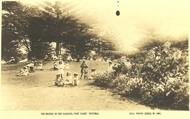
Postcard, kodak Austral, Botanical Gardens Port Fairy Mound area
Botanical Gardens Port Fairy Mound area 1900? The Port Fairy Botanical Gardens were formed in 1856 making it one of the earliest gardens in Victoria. The first curator was James Prior, he was paid fifty-two pounds per annum. He was an outstanding curator having been apprenticed to the trade in England at the age of 12, his brother Edward in later years was the Curator of the Koroit Gardens. Prior retired in 1903. During the years of his curatorship Port Fairy was said to have the best gardens outside the city of Melbourne, he was constantly in touch with Baron Von Mueller and later Guilfoyle of the Royal Botanical Gardens of Melbourne. In the early years plants from all over the world were planted here with varying rates of success many of them sent by Baron Von Mueller. In the 1930’ and 40’s the gardens were still very beautiful, and the curator was Roy Manuell. The beautiful iron gates at the entrance were destroyed in the 1946 floods and were replaced in 1989 using some of the material from the original gates. From the 1950’s on the gardens went into a state of decline, much being taken up by the caravan park until in 1986, after a public meeting ‘Friends of the Gardens’ was founded when the entrance section was restored. Sepia photographThe Mound in the Gardens Port Fairy Victoria- Real Photo Series M.1994botanical, garden