Showing 289 items
matching moorabbin council
-
 Bayside Gallery - Bayside City Council Art & Heritage Collection
Map, Department of Lands and Survey, Land under the control of the City of Sandringham, 1962
The cadastral map showing land under the control of the City of Brighton in 1962.map, plan, foreshores, sndringham, hampton, beaumaris, cheltenham, department of lands and survey, cartographic material, moorabbin, black rock, street map, city of sandringham, board of lands and works -
 Bayside Gallery - Bayside City Council Art & Heritage Collection
Map - print, Melbourne and Metropolitan Board of Works, Interim development order: Brighton, Moorabbin and Sandringham, 1959
The Melbourne and Metropolitan Board of Works (now Melbourne Water) was established in 1891. From that time, as part of their work laying water and sewerage connections, they created detailed plans of houses and other buildings in the Melbourne metropolitan area. In 1956 it acquired powers to construct and maintain highways and bridges, protect and improve the foreshores and create and maintain parks within the metropolitan region. This Interim development order comprises part of the municipalities of Brighton, Moorabbin and Sandringham and was made on 20 October 1959.brighton, moorabbin, sandringham, melbourne and metropolitan board of works, map, town planning, cartographic material, interim development order, bayside -
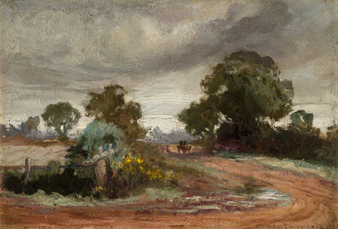 Bayside Gallery - Bayside City Council Art & Heritage Collection
Painting - oil on canvas on board, Charles Douglas Richardson, After the rain, Moorabbin, 1910
oil on canvas on boardlandscape, moorabbin, road, charles douglas richardson, horse, cart, tree, farm -
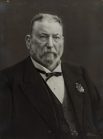 Bayside Gallery - Bayside City Council Art & Heritage Collection
Photograph - gelatin silver photograph, Talma & Co, Sir Thomas Bent, c. 1907
sir thomas bent, thomas bent, speaker, mayor, premier, brighton, moorabbin, land speculator, local government, councillor, official, member of lower house, portrait, parliament -
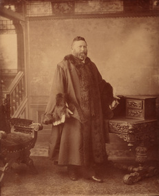 Bayside Gallery - Bayside City Council Art & Heritage Collection
Photograph - sepia photograph, Councillor Thomas Bent, Mayor of Brighton
thomas bent, politician, mayor, premier, land speculator, speaker, local government, councillor, member of lower house, portrait, brighton, moorabbin, mayoral robes, mayor of brighton, premier of victoria -
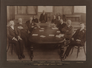 Bayside Gallery - Bayside City Council Art & Heritage Collection
Photograph - sepia photograph, Frazer and Vallance, Sandringham Borough Council, May 1917, 1917
Councillors and the mayor seated at table while attending the first Sandringham Borough Council meeting after severance from the Shire of Moorabbin. Shown L to R: Cr. C.A. Hartsman; Cr. T.G. Farrant; Cr. W.T.C. Kelly; Cr. B. Champion; Cr. B.J. Ferdinando (Mayor) [standing]; Cr. O.R. Snowball Esq. (M.L.A.); Cr. E.L. Belyea; Cr. H. B. Grace; Cr. G.W. Knott; Cr. F.W. Hearnden.councillor, sandringham, local government, municipality, mayor, justice of the peace, cr b.j. ferdinando, borough of sandringham, cr. c.a. hartsman, cr. t.g. farrant, cr. w.t.c. kelly, cr. b. champion, cr. o.r. snowball, cr. e.l. belyea, cr. h. b. grace, cr. g.w. knott, cr. f.w. hearnden, council meeting -
 Bayside Gallery - Bayside City Council Art & Heritage Collection
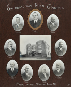
Photograph - gelatin silver photograph, Talma & Co, Sandringham Town Council, Proclaimed 9th day of April,1919, 1919
Sandringham was originally part of the Shire of Moorabbin. On 28 February 1917, Sandringham was severed from Moorabbin and incorporated as the Borough of Sandringham. It was proclaimed a Town on 9 April 1919 and a City on 21 March 1923. The Sandringham Town Hall, located on Abbott Street, Sandringham (formerly the mechanics institute) was demolished in 1994.councillor, sandringham, local government, municipality, mayor, portrait, city of sandringham, sandringham town hall, abbott street, cr. e.l. belyea, cr. b. champion, cr. h.b. grace, cr. c.a. hartsman, cr. j.e.d. beck, cr. b.j. ferdinado, cr. t.g. farrant, cr. w.t.c. kelly, cr. g.w. knott, town, proclamation, bayside, hampton, black rock -
 Bayside Gallery - Bayside City Council Art & Heritage Collection
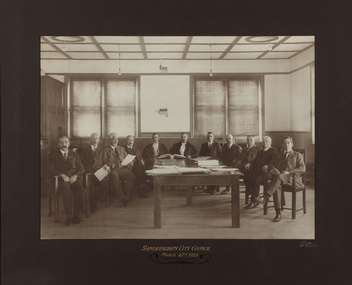
Photograph - gelatin silver photograph, Sarony & Co, The first meeting of the City of Sandringham Council, 21st March, 1923, 1923
Photograph taken on the day that the Town of Sandringham became a City, and the first meeting of the City of Sandringham Council. Sandringham was originally part of the Shire of Moorabbin. On 28 February 1917, Sandringham was severed from Moorabbin and incorporated as the Borough of Sandringham. It was proclaimed a Town on 9 April 1919 and a City on 21 March 1923.councillor, sandringham, local government, municipality, mayor, cr. c.a. hartsman, cr. t.g. farrant, cr. g.w. knott, cr. f.n. gibbs, h.t. williams, town clerk, engineer, cr. j.t.d. beck, b.r. sunderland, cr. w.h. kay, cr. r. chisholm, cr. h.b. grace, cr. j.m. ramsay, city, proclamation, council meeting, city of sandringham -
 Bayside Gallery - Bayside City Council Art & Heritage Collection
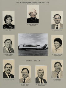
Photograph, City of Sandringham Jubilee Year 1923-83, 1983
Sandringham was originally part of the Shire of Moorabbin. On 28 February 1917, Sandringham was severed from Moorabbin and incorporated as the Borough of Sandringham. It was proclaimed a Town on 9 April 1919 and a City on 21 March 1923. This compilation marks the Jubilee year of the City of Sandringham.sandringham municipal office, councillor, mayor, portrait, municipal building, sandringham, bayside, cr. carmen watson, cr. lesley falloon, cr. paul gundry-white, cr. john merkus, cr. pauline reynolds, cr. laurence bottomly, cr. clem waters, cr. michael harwood, cr. jim bissett, jubilee year -
 Bayside Gallery - Bayside City Council Art & Heritage Collection
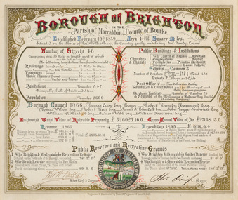
Certificate - Illuminated certificate, Hamel & Fergsuon, Brighton Municipal Certificate, 1866
bayside city council, borough of brighton, illuminated, certificate, population, rates, public buildings, mayor, town clerk, surveyor, councillors, council, borough, county of bourke, thomas crisp, cr t. crisp, census, parish of moorabbin, hamel & ferguson, coat of arms -
 Bayside Gallery - Bayside City Council Art & Heritage Collection
Map, Department of Crown Lands and Survey, Moorabbin, County of Bourke, c. 1918
The cadastral map of the Parish of Moorabbin in Victoria (L.6104) shows parish boundaries and land ownership c. 1918 when Sandringham was a Borough.moorabbin, county of bourke, map, plan, land subdivision, land titles, foreshores, sndringham, hampton, beaumaris, highett, cheltenham, department of lands and survey, land owners, cartographic material, borough of sandringham, brighton -
 Bayside Gallery - Bayside City Council Art & Heritage Collection
Map, Department of Crown Lands and Survey, Melbourne and Suburbs, City of Sandringham, 1917-1926
map, plan, foreshores, sndringham, hampton, beaumaris, cheltenham, department of lands and survey, cartographic material, borough of sandringham, moorabbin, black rock, street map, city of sandringham -
 Moorabbin Air Museum
Booklet - Pilot'S Notes General RAF
Historical Details: . Description: 132 pages. Published by Gout of India - RAF Air Council. Published 1943. AP 2095, 2nd Edition. RAF General Pilot's Notes. Level of Importance: World -
 Kew Historical Society Inc
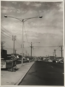
Photograph, Stuart Tompkins Studio, Electricity Supply Poles, South Road, Moorabbin, 1965
Research provided by Stuart Tompkins Studio, Box Hill, into alternatives for median strip street lighting to be used in Burke Road, Kew. The photographers identified variants in different suburbs appropriate to Kew's needs.The series from which the photograph is drawn provides a snapshot by a commercial photographic studio of each named vicinity in 1965 as well as providing examples of public works infrastructure being commissioned by local government in the 1960s. The photos originally formed part of the Engineering Department's files in the City of Kew before being donated to the kew Historical Society.Electricity Supply Poles, South Road, Moorabbin, 1965. Stuart Tompkins Studio provided this photograph for the Kew City Council. The photograph of South Road, Moorabbin, west of Jasper Road, looking east depicts steel poles with two lamps in a median strip and supply wires from pole to pole. The poles were described as 100′ apart. The notation on the rear of the photograph was that there were lamps along the median strip except at intersections. A wooden pole is recognised as supporting heavy supply lines across the road. The steel poles in the photograph were said to be between 3′ to 3.5′ whereas the wooden poles were three to 12.25″ in diameter. [There are three copies of this photograph in the Collection.] Typed inscription on reverse: "Electricity Supply Poles. Photographed for Kew City Council 8/2/65. No.2 South Road - Moorabbin, west of Jasper Road, looking east. Steel poles with two lamps in median strip and supply wires from pole to pole along median strip (poles only 100' apart). Lamps along median only except at intersections. Wooden pole supports heavy supply lines across the road. Wooden poles 3' up and 8 1/2" dia. Wooden poles 3' up and 12 1/2 dia." Studio stamp: "Stuart Tompkins Studio. 547 Station Street, Box Hill. WX1439."public infrastructure -- kew (vic.), city of kew - engineers department -
 Kew Historical Society Inc
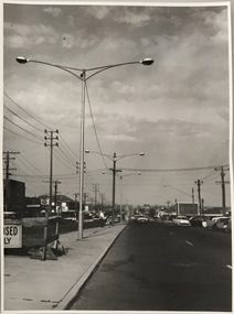
Photograph, Stuart Tompkins Studio, Electricity Supply Poles, South Road, Moorabbin, 1965
Research provided by Stuart Tompkins Studio, Box Hill, into alternatives for median strip street lighting to be used in Burke Road, Kew. The photographers identified variants in different suburbs appropriate to Kew's needs.The series from which the photograph is drawn provides a snapshot by a commercial photographic studio of each named vicinity in 1965 as well as providing examples of public works infrastructure being commissioned by local government in the 1960s. The photos originally formed part of the Engineering Department's files in the City of Kew before being donated to the kew Historical Society.Electricity Supply Poles, South Road, Moorabbin, 1965. Stuart Tompkins Studio provided this photograph for the Kew City Council. The photograph of South Road, Moorabbin, west of Jasper Road, looking east depicts steel poles with two lamps in a median strip and supply wires from pole to pole. The poles were described as 100′ apart. The notation on the rear of the photograph was that there were lamps along the median strip except at intersections. A wooden pole is recognised as supporting heavy supply lines across the road. The steel poles in the photograph were said to be between 3′ to 3.5′ whereas the wooden poles were three to 12.25″ in diameter. [There are three copies of this photograph in the Collection.] Typed inscription on reverse: "Electricity Supply Poles. Photographed for Kew City Council 8/2/65. No.2 South Road - Moorabbin, west of Jasper Road, looking east. Steel poles with two lamps in median strip and supply wires from pole to pole along median strip (poles only 100' apart). Lamps along median only except at intersections. Wooden pole supports heavy supply lines across the road. Wooden poles 3' up and 8 1/2" dia. Wooden poles 3' up and 12 1/2 dia." Studio stamp: "Stuart Tompkins Studio. 547 Station Street, Box Hill. WX1439."city of kew -- engineers department, public infrastructure -- kew (vic.) -
 Kew Historical Society Inc
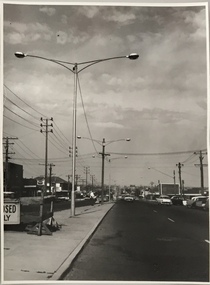
Photograph, Stuart Tompkins Studio, Electricity Supply Poles, South Road, Moorabbin, 1965
Research provided by Stuart Tompkins Studio, Box Hill, into alternatives for median strip street lighting to be used in Burke Road, Kew. The photographers identified variants in different suburbs appropriate to Kew's needs.The series from which the photograph is drawn provides a snapshot by a commercial photographic studio of each named vicinity in 1965 as well as providing examples of public works infrastructure being commissioned by local government in the 1960s. The photos originally formed part of the Engineering Department's files in the City of Kew before being donated to the kew Historical Society.Electricity Supply Poles, South Road, Moorabbin, 1965. Stuart Tompkins Studio provided this photograph for the Kew City Council. The photograph of South Road, Moorabbin, west of Jasper Road, looking east depicts steel poles with two lamps in a median strip and supply wires from pole to pole. The poles were described as 100′ apart. The notation on the rear of the photograph was that there were lamps along the median strip except at intersections. A wooden pole is recognised as supporting heavy supply lines across the road. The steel poles in the photograph were said to be between 3′ to 3.5′ whereas the wooden poles were three to 12.25″ in diameter. [There are three copies of this photograph in the Collection.] Typed inscription on reverse: "Electricity Supply Poles. Photographed for Kew City Council 8/2/65. No.2 South Road - Moorabbin, west of Jasper Road, looking east. Steel poles with two lamps in median strip and supply wires from pole to pole along median strip (poles only 100' apart). Lamps along median only except at intersections. Wooden pole supports heavy supply lines across the road. Wooden poles 3' up and 8 1/2" dia. Wooden poles 3' up and 12 1/2 dia." Studio stamp: "Stuart Tompkins Studio. 547 Station Street, Box Hill. WX1439."stuart tompkins studio, street lighting, south road (moorabin) 1965, public infrastructure -- city of kew, city of kew -- engineer's department -
 Glen Eira City Council History and Heritage Collection
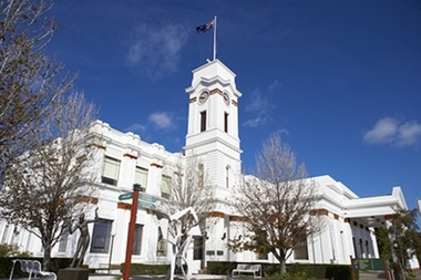
Photograph - Building, Glen Eira Town Hall, 1884
Originally known as Caulfield Shire Hall, the original 1884 building was designed by Shire surveyor Sydney Smith. In 1931 the Caulfield Town Hall, as it was then known, was remodelled to include the main hall and foyer and a Neo-Grecian portico with Corinthian Order columns. Major works completed since 1945 include Caulfield Arts Complex (opened 20 August 1988), Caulfield Library (opened 4 December 1993) and the award-winning Caulfield Municipal Offices extension which opened on 24 February 1991. The building is listed as No. H0106 in the GECC Heritage Overlay Schedule. The site also includes a Significant Tree (H&H Register No. 034). Brick exterior of two storey building painted white and featuring pillared portico entrance and solid glass doors on Glen Eira road facing north. On the eastern side of the portico is a two storey clock tower with clock surmounted by a flagpole and flag. Some of the eastern section of the building is original with various alterations over the years. The award winning service centre and offices in the westerly aspect of the town hall were extended on to the original buliding in 2000.building, town hall, council, local government, caulfield, glen eira, moorabbin, sydney smith -
 Glen Eira City Council History and Heritage Collection
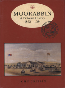
Book, "Moorabbin: A Pictorial History, 1862 - 1994", 1995
Copy of pictorial history book written by John Cribbin significantly signed by councillors and the author on the first page.The words "Moorabbin: A Pictorial History, 1862 - 1994" printed in brown colour in and oval at the top of a red, hard paper cover book, copy of an image of horse and carts and Gregg's Plough and Harrow Hotel, South Brighton below. Below that name of author "John Cribbin" is printed. -
 Glen Eira City Council History and Heritage Collection
Plaque, commemorative, c. 1997
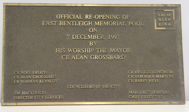
Plaque was previously located on the front wall of the East Bentleigh Memorial Pool alongside the original City of Moorabbin Memorial Pool plaques. The plaques were removed from the wall when the building was demolished for the GESAC development. The Moorabbin pool plaques were restored and relocated to the rhs wall in the entrance to GESAC. Plaque, bronze rectangular with polished bronze border and relief lettering and brown textured background. The plaque commemorates the official re-opening of the East Bentleigh Memorial Pool by the Mayor, Cr Alan Grossbard in 1997.Polished bronze relief lettering in upper centre of plaque: "OFFICIAL RE-OPENING OF / EAST BENTLEIGH MEMORIAL POOL / ON / 7 DECEMBER, 1997 / BY / HIS WORSHIP THE MAYOR / CR ALAN GROSSBARD" lhs, rhs, centre: CR NOEL ERLICH / CR ALAN GROSSBARD / COUNCILLORS OF THE CITY / CR RUSSELL LONGMUIR / CR VERONIKA MARTENS / CR BARRY NEVE / JIM MACKINNON / DIRECTOR CITY SERVICES / MARGARET DOUGLAS / CHIEF EXECUTIVE" -
 Glen Eira City Council History and Heritage Collection
Plaque, commemorative
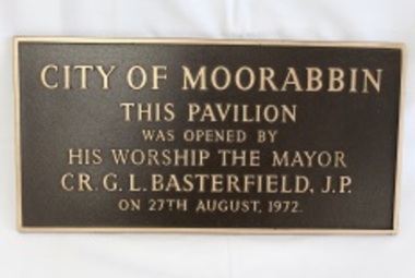
Plaque, bronze rectangular with polished bronze border and relief lettering and brown textured background. The plaque commemorates the opening of the Moorabbin Pavilion by the Mayor CR G. L. Basterfield J.P. on the 27th August 1972. Inscription: City of Moorabin / This pavilion / was opened by / his worship the mayor / CR. G. L. Basterfield J.P / on 27th August 1972. -
 Glen Eira City Council History and Heritage Collection
Book, "Moorabin: A Pictorial History 1862 - 1994", 1995
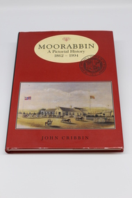
Copy of pictorial history book written by John Cribbin with dedication to former Mayor, Cr Noel Erich on inside of cover: "To Cr Noel Elrich, Mayor of the City of Glen Eira from Moorabbin Historical Society and the Glen Eira Volunteers. International Year of Volunteers 2001".Hard cover book with a red jacket with the title "Moorabbin: A Pictorial History, 1862 - 1994" printed in brown colour in and oval at the top of a red , hard paper cover book, copy of an image of horse and carts and Gregg's Plough and Harrow Hotel, South Brighton below. Written on inside of cover: "To Cr Noel Elrich, Mayor of the City of Glen Eira from Moorabbin Historical Society and the Glen Eira Volunteers. International Year of Volunteers 2001". -
Glen Eira City Council History and Heritage Collection
Document (Item) - Newspaper (digital), Caulfield Contact
The Caulfield Contact was the official newspaper of the City of Caulfield from 1976-1994. The City of Caulfield was the Municipal Council for an area of the South Eastern suburbs of Melbourne, including Brighton East, Carnegie, Caulfield, Elsternwick, Gardenvale, Glen Huntly, McKinnon, Murrumbeena, Ormond and St Kilda East. Following the amalgamation of City of Caulfield and parts of the City of Moorabbin in 1994, the municipality was renamed the City of Glen Eira. The Caulfield Contact was replaced by the Glen Eira News. 320-001-1976-001-001-07-28 Vol 1 edition 1 July 1976 Twenty-fifth (25th) anniversary of home help service; Profiles on Councillors Ray Mann, David Nolan; Murray and Wells call out for historical material; Resident's proposal for ward boundary changes accepted by Council, Profiles Councillor Bert Caldwell, Stan Hunter Town Hall Reprieve, History of Caulfield First Caulfield Arbor Day, Results of Council Elections held on 26 August 1976 city of caulfield, caulfield, history of caulfield, glen eira -
Glen Eira City Council History and Heritage Collection
Document (Item) - Newspaper (digital), Caulfield Contact
The Caulfield Contact was the official newspaper of the City of Caulfield from 1976-1994. The City of Caulfield was the Municipal Council for an area of the South Eastern suburbs of Melbourne, including Brighton East, Carnegie, Caulfield, Elsternwick, Gardenvale, Glen Huntly, McKinnon, Murrumbeena, Ormond and St Kilda East. Following Amalgamation of City of Caulfield and parts of the City of Moorabbin in 1994, the Caulfield Contact was followed by the Glen Eira News. Includes references to the following: Children's Neighbourhood Centre Caulfield; Fire destroyed Caulfield Park Bowling Club; Naming of Harleston Park; Home Handyman Service; Profiles Councillors Peter Baitz, Ron Walters; Carnegie-Glenhuntly Football Club formed Council drops approval of rail crossings over Neerim and Glenhuntly Roads; Profiles Councillor Alwyn Samuel, Glen Richards; First stage of Nepean Highway widening; Minister approved re-subdivision; Council spills; Exciting development of Caulfield Park; Profiles Councillor Max Blair, Councillor Brian Rudzki; Tram shelter classified by National Trustcity of caulfield, caulfield, glen eira, city of glen eira, caulfield contact, children's neighbourhood centre caulfield, fire destroyed caulfield park bowling club, naming of harleston park, home handyman service, profiles councillors peter baitz, ron walters, carnegie-glenhuntly football club formed, council drops approval of rail crossings over neerim and glenhuntly roads, profiles councillor alwyn samuel, glen richards, first stage of nepean highway widening, minister approved re-subdivision, council spills, exciting development of caulfield park, profiles councillor max blair, councillor brian rudzki, tram shelter classified by national trust -
Glen Eira City Council History and Heritage Collection
Document (Item) - Newspaper (digital), Caulfield Contact
The Caulfield Contact was the official newspaper of the City of Caulfield from 1976-1994. The City of Caulfield was the Municipal Council for an area of the South Eastern suburbs of Melbourne, including Brighton East, Carnegie, Caulfield, Elsternwick, Gardenvale, Glen Huntly, McKinnon, Murrumbeena, Ormond and St Kilda East. Following Amalgamation of City of Caulfield and parts of the City of Moorabbin in 1994, the Caulfield Contact was followed by the Glen Eira News. Contains References to the following Freedom of Entry to 3rd ordinance of the RAAOC, visit by Sir Zelman Cowen, Return to Rosstown, A 'spacy new home' (nursery at Caulfield Park), Profile on Gus Theobold, Meals on Wheels Aviary completed Caulfield Park. Profile resident Gus Theobold. Cr Irene Capek win Herald Australia Day essay prize. Caulfields Meals on Wheels set Victorian record. Historical feature Return to Rosstown. New ambulance station Glenhuntly and Clarinda roads opens. Volume 4 Number 5 Date 03 August 1978 Features Where and How to Vote in council election. Cr Irene Capek retires from council. Profiles election candidates. Image: Image Cr Irene Capek. Images of election candidates. Volume 5 Number 1 Date 14 September 1978 Freedom of Entry to 3rd ordinance of the RAAOC, visit by Sir Zelman Cowen, Subjects from Carol: GG Sir Zelman Cowen and Lady Cowen offical visit. Off street carpark project underway Pyne St and Hawthorn Rd. City Manager Graeme Caldwell submits plans for Townhall renovations. Action plan for development of Elsternwich Shopping precint to be developed. Freedom of Entry ceremony. Profile Rosemary Keppel. Booran Motors Glenhuntly donate dual control Holden Gemini to Caulfield Tech school pre-driver education program. council election results. Comments from elected Crs Jack Campell, Bob Baxter, Dorothy Ford, Brian Rudzki. Promotion of Caulfield Institute of Technology and TAFE. Image: Image Sir Zelman Cowen, Lady Cowen. Images Freedom of Entry ceremony and citizens attending. Image Rosemary Keppel. Cartoon pre-driver education program. Image Mayor Cr Geoff Patience in robes. Volume 5 Number 2 Date 26 October 1978 Rate rise 5.73% announced. Readership of Caulfield Contact surveyed. Caulfield ranger Reg Dixon and members of works dept rescue duck family from drain and reinstate them to Caulfield Racecourse dam. Profile resident and teacher Claire Manning. Image: Image of Reg Dixon and the rescued ducks. Image Claire Manning and students at Waverley Private school. city of caulfield, caulfield, glen eira, city of glen eira, caulfield contact, freedom of entry to 3rd ordinance of the raaoc, visit by sir zelman cowen, return to rosstown, a 'spacy new home' (nursery at caulfield park), profile on gus theobold, meals on wheels -
Glen Eira City Council History and Heritage Collection
Document (Item) - Newspaper (digital), Caulfield Contact
The Caulfield Contact was the official newspaper of the City of Caulfield from 1976-1994. The City of Caulfield was the Municipal Council for an area of the South Eastern suburbs of Melbourne, including Brighton East, Carnegie, Caulfield, Elsternwick, Gardenvale, Glen Huntly, McKinnon, Murrumbeena, Ormond and St Kilda East. Following Amalgamation of City of Caulfield and parts of the City of Moorabbin in 1994, the Caulfield Contact was followed by the Glen Eira News.city of caulfield, caulfield, glen eira, city of glen eira, caulfield contact -
Glen Eira City Council History and Heritage Collection
Document (Item) - Newspaper (digital), Caulfield Contact
The Caulfield Contact was the official newspaper of the City of Caulfield from 1976-1994. The City of Caulfield was the Municipal Council for an area of the South Eastern suburbs of Melbourne, including Brighton East, Carnegie, Caulfield, Elsternwick, Gardenvale, Glen Huntly, McKinnon, Murrumbeena, Ormond and St Kilda East. Following Amalgamation of City of Caulfield and parts of the City of Moorabbin in 1994, the Caulfield Contact was followed by the Glen Eira News.city of caulfield, caulfield -
Glen Eira City Council History and Heritage Collection
Document (Item) - Newspaper (digital), Caulfield Contact
The Caulfield Contact was the official newspaper of the City of Caulfield from 1976-1994. The City of Caulfield was the Municipal Council for an area of the South Eastern suburbs of Melbourne, including Brighton East, Carnegie, Caulfield, Elsternwick, Gardenvale, Glen Huntly, McKinnon, Murrumbeena, Ormond and St Kilda East. Following Amalgamation of City of Caulfield and parts of the City of Moorabbin in 1994, the Caulfield Contact was followed by the Glen Eira News.city of caulfield, caulfield