Showing 1506 items matching "acres"
-
 Bendigo Historical Society Inc.
Document - EXTRACT: PAGES ON AUSTRALIAN HISTORY OF WINE PRODUCTION
Extract - 4 pages (pages 5 - 8 of ??) on Australian history of wine production - author , date??. On page 8 is reference to Bendigo region - reference to Bladier; Delscher (sic); Dr. Backhaus; Grieffenhagen; Grosse; Fuchs; Fischer; Fick (Ruedin and Kahland added in handwriting); government viticulturist research station'' 800 acres earmarked for Huntly; Tooronga Vineyard, Mandurang;rural industry, viticulture, wine production -
 Bendigo Historical Society Inc.
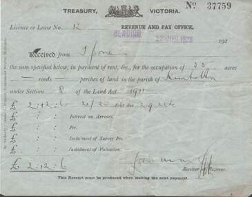
Document - L. PROUT COLLECTION: TREASURY VICTORIA RECEIPT
Treasury Victoria receipt No. 37759. Licence or Lease no. 12. Revenue and pay office, Bendigo 22 June, 1923. Received from mr. Jones the sum specified below in payment of rent for the occupation of 35 acres of land in the parish of Kimbolton under section 8 of the land act 1911. The sum paid is 2 pounds, 12 shillings and 6 pence.document -
 Whitehorse Historical Society Inc.
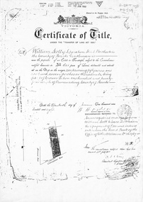
Document, Certificate of Title, 1/06/1908
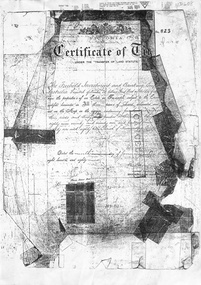
Photocopy of Certificate of Title Vol 3271 Fol 654003, 50 acres fronting on Canterbury Road, including Scott Street being part of Crown Portion 124, Parish of Nunawading, County of Bourke, in the name of William Scott, 20 June 1908; transfers to 8 October 1936 with notes of previous owners of parts of lot 124 from November 1858.scott street, mitcham, scott, william, polak, nelson, land subdivision, canterbury road, vermont, mitcham road, isaak, johnson, miller frederick, james, becker, lydia malvina, huffey, harry, graham, annie bella, langford, william allan, emily mary, caplin, ethel grace, armstrong, mary, cook, joseph allan, isabella, isaac william, mettzke, frederick oscar, whitmore, doris margaret, elizabeth, thomas, stephen, beach, william griffin, brown, hosking, bonnel, alphonse, saul, martin, richards, twose, richard frederick, charles, george, ham, cornelius job, sprigg, shaw, gavin, william barker, jane, mcclelland, david goodwin, thomas robert -
 Whitehorse Historical Society Inc.
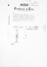
Document, Forest Hill, 24/08/1932
Photocopy of Certificate of TitlePhotocopy of Certificate of Title Vol 5807 Fol 1161261 to Carl Julius Otto Draeger for four acres of land being part of Crown Portion 93 at Forest Hill; with verso of C/T Vol 1900 Fol 37984 recording transfers to Lydia Esther Lovell, Lillian Sarah Frances Lovell, William John and Mabel Jessie Brown.Photocopy of Certificate of Title draeger, carl julius otto, canterbury road, forest hill, glen valley road, lovell, lydia esther, lillian sarah frances, brown, william john, mabel jessie -
 Bendigo Historical Society Inc.
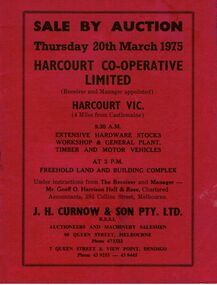
Document - IAN DYETT COLLECTION: AUCTION CATALOGUE - HARCOURT CO-OPERATIVE LIMITED
Red covered auction catalogue with black printing for a sale held on the 20th March 1975 at the Harcourt Co-operative Limited. For sale was extensive hardware stocks, workshop & general plant, timber and motor vehicles. Also approx. 2 1/2 acres Freehold Land and some buildings. J. H. Curnow & Son Pty Ltd. were the auctioneers.business, auctioneers, j h curnow & son pty ltd, ian dyett collection - auction catalogue - harcourt co-operative limited, geoff o harrison hall & rose, j h curnow & son pty ltd, f c dyett, c hill, i m dyett, bolton bros print -
 Kew Historical Society Inc
Equipment - Theatre Supplies, Boxed Greasepaint Sticks, c.1975
The Rockingham Red Cross Centre in Kew provided convalescence and rehabilitation for war veterans suffering nervous conditions resulting from the Second World War. The building had been given to the Australian Red Cross by the owner of the house, Mrs Syme in 1940. In the early days of the centre, patients performed plays for fellow patients and staff members. This small box of theatrical makeup, or greasepaint, would have been used at the Centre on one or more of these occasions. The donor, Rosemary Lade, worked at the Centre as an occupational therapist, 1971-2 and 1974-7. During these years, play readings were held, but performances were not staged. The Rockingham Red Cross Centre closed in 1977, and following its closure, the donor retrieved the box of greasepaints from the Occupational Therapy Department. A box of greasepaint from the Rockingham Red Cross Centre, Kew. Square wooden box, containing sticks of greasepaint used for theatrical makeup. The used sticks of greasepaint are wrapped in foiled paper, printed with information about the colour and the maker/retailer: L. Leichner (London) Ltd. Leichner House, 30/32 Acre Lane, / London, S.W.2. theatrical makeup, greasepaint, rockingham, rockingham red cross centre, syme family, rosemary lade, occupational therapy - theatre -
 University of Melbourne, Burnley Campus Archives
Plan - Photocopy, 1. [Botanic Gardens] upon the retirement of Baron Von Mueller from the Directorship, 1873. 2. Botanic Gardens, 1909, showing alterations and additions effected since 1873. By W.R. Guilfoyle. Director, c.1873-1909
Photocopies. (1) 2 copies, "[Botanic Gardens] upon the Retirement of Baron von Mueller from the Directorship, 1873." Source unknown, addition of 30 acres in 1875 noted. (2) 2 copies, "Botanic Gardens, 1909, showing alterations and additions effected since 1873 by W. R. Guilfoyle, Director." Source unknown. Shows grid lines.ferdinand von mueller, w.r. guilfoyle -
 Eltham District Historical Society Inc
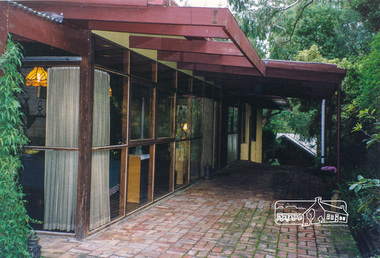
Photograph, Gayle Blackwood, 50 Livingstone Road, Eltham, May 1998, 1998
Alistair Knox's 1959 designed mudbrick home. Note that the extension is not Knox's design. 4 bedrooms on 1/3 acreThree colour prints 10 x 15 cm Four newspaper clippings One Ian Reid Auction flyer (A4)houses, mudbrick, alistair knox, gayle blackwood collection, ian reid real estate, livingstone road, eltham -
 Whitehorse Historical Society Inc.
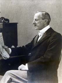
Photograph, Dr, L.L. Smith
Dr. L.L. Smith owned 250 acres in an area bounded by Boronia, Canterbury and Heatherdale Roads, known as L.L. Vale.2 copies of Photo of Dr. L.L. Smith, 1830 - 1910smith, l.l., dr., l.l. vale -
 City of Moorabbin Historical Society (Operating the Box Cottage Museum)
Document, laminated List of Pioneers Moorabbin Parish, c1985
This list shows the names of the Pioneer settlers with the amount of Acres, the date purchased from The Crown and the Lot or Portion Number in the Land of the Henry Dendy Special Survey of Brighton 1841, in the County of Bourke , Victoria. The Squatters ,who arrived in the area first, used the land for grazing sheep and cattle. The Squatters had the right to graze unoccupied Crown land for ₤10 per year rental and a per capita payment for animals grazed. They could develop , improve and clear the land for the purpose of the tenancy but ownership was not permitted. When the land became useful The Crown put it on the market and the developers took over whilst the Squatters lost the improved land, dwellings and out buildings, there being no compensation paid. Squatters named John and Thomas Martin 1840-41; Richard and John King 1840- 1854 ; M.N.M.Moysey and M.J.Bickford 1841-1852 ; James McMahon 1846-1853 ; Daniel MacKinnon 1839- 1840. The 5120 Acres of the Henry Dendy Special Survey 1841were divided into approx. 83 Portions / Lots with varying acreage . Josiah Holloway, a speculator purchased 625 acres of the King Brothers run and re-sectioned the land into 2 acre Lots for Sale as market gardens. It was called The Two Acre Village later known as Cheltenham. A List of the names of The Pioneers in County of Burke Victoria c1841-1887 compiled by Lesley A. Schumer in 1985 A 3 Laminated display on wall in room 2 THE PIONEERS, Signed L.A. Schumer moorabbin, brighton, cheltenham, bentleigh, market gardeners, pioneers, early settlers, dendy henry, henry dendy's special survey 1841, squatters, king john, martin john, mcmahon james, two acre village, holloway josiah, were jonathan binn, grazing, cattle, sheep, market gardens, -
 Warrnambool and District Historical Society Inc.
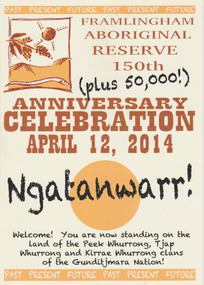
Booklet - 150 plus Framlingham Aboriginal Reserve, 2014
The Framlingham Aboriginal Trust is a shareholder- owned organization established under Victorian law in 1971. The Trust owns and manages part of what was the old Aboriginal Reserve established in 1861 under the auspices of the Church of England. In 1865 the Reserve was officially established as a Government-managed aboriginal station. By 1970 the original area of 3,500 acres was whittled down to 585 acres and handed over to the Framlingham Aboriginal Trust. Framlingham is today one of only two discrete aboriginal communities in Victoria where aborigines live on aboriginal land and is an important part of the district cultural life. The celebration of the 150th anniversary of Framlingham’s establishment in 2014 was therefore a significant event in the district’s history and the booklet is a permanent reminder of this.This is a small booklet of 8 pages containing information on the 150th celebrations of Framlingham Aboriginal Reserve in 2014. The cover has a cream background with illustrations and printed material in yellow, black and brown. The pages are stapled. The booklet includes photographs, maps, illustrations and printed material. Front cover: ‘Framlingham Aboriginal Reserve 150th Anniversary Celebration, April 12, 2014, Ngatanwarr’ etc Back cover: Acknowledgements of sponsors and written material framlingham aboriginal trust, western district aborigines, peek whurrong, kirrae whurrong, gunditjmara, tjap whurrong -
 Bendigo Historical Society Inc.
Document - RESEARCH PAPERS: HISTORY OF BENDIGO SALEYARDS, 1869
In 1859 6 acres were set aside for use as a cattle market and this was established between January and July 1861 in Charleston Road, Bendigo. By 1889 this had expanded to 13 acres. It initially included an abattoir, butchers, tanners and soap makers. In 1893 a rail spur was opened to prevent the need to drive cattle through residential areas. The yards moved to their current site at Huntly in 1997.HISTORY OF BENDIGO SALEYARDSbendigo saleyards, cattle market -
 Eltham District Historical Society Inc
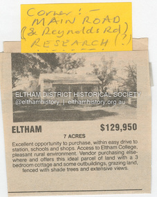
Document - Property Binder, 1480 Main Road, Eltham
Home of the Dodkins family Newspaper advertisement: undated, Sale of 1480 Main Road, 7 acres, for $129,950, photograph of existing cottage.main road, eltham, property, research (vic), dodkins family home -
 Eltham District Historical Society Inc
Photograph, Kinglake National Park, Wrights Falls
The Wright family owned the land on which the Falls were situated and were sold for a penny an acre according to a Wright family story. This photo forms part of a collection of photographs gathered by the Shire of Eltham for their centenary project book,"Pioneers and Painters: 100 years of the Shire of Eltham" by Alan Marshall (1971). The collection of over 500 images is held in partnership between Eltham District Historical Society and Yarra Plenty Regional Library (Eltham Library) and is now formally known as 'The Shire of Eltham Pioneers Photograph Collection.' It is significant in being the first community sourced collection representing the places and people of the Shire's first one hundred years.Digital imagesepp, shire of eltham pioneers photograph collection, kinglake, kinglake national park, wrights falls -
 Whitehorse Historical Society Inc.
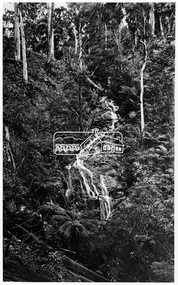
Article, 70 Years of St. Thomas the Apostle, March 2024
On 17/03/2024 the St. Thomas the Apostle parish and primary school's 70th anniversary will be celebratednon-fictionOn 17/03/2024 the St. Thomas the Apostle parish and primary school's 70th anniversary will be celebratedst. thomas the apostle catholic church blackburn, st. thomas the apostle primary school, cheung anna -
 Linton and District Historical Society Inc
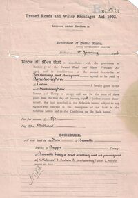
Permit, Permit issued in 1905 under 'Unused Roads and Water Frontages Act, 1903', 1/1/1905
Licence for use of 11 acres of unused roads in the Shire of Grenville for 3 years at a charge of one pound eighteen shillings and six pence.White oblong paper headed "Unused Roads and Water Frontages Act 1903". Licence number 1767, dated 1st January 1905, issued by Department of Public Works to Armstrong Kerr of Linton. Document is printed on both sides.On back: "2743. A. Kerr".armstrong kerr, agricultural activity, roadside grazing permit -
 Bendigo Historical Society Inc.
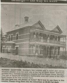
Newspaper - JENNY FOLEY COLLECTION: NURSES' QUARTERS
Bendigo Advertiser ''The way we were'' from 2000. Nurses' quarters: Bendigo's first hospital was a wood and canvas structure erected on a two-acre site at the top of Short Street. Eventually architect W.C. Vahland designed a hospital built on Rowan Street, Bendigo. This part of Sandhurst remained a fashionable area with some of the city's finest homes at the time erected there. The clip is in a folder.newspaper, bendigo advertiser, the way we were -
 Bendigo Historical Society Inc.
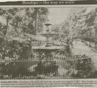
Newspaper - JENNY FOLEY COLLECTION: ROSALIND PARK
Bendigo Advertiser ''The way we were'' from 2000. Rosalind Park: consisting of 60 acres, the land was set aside from a grant in 1857. Many English and Australian trees were planted with promenades and roads. Some of the earliest buildings erected within this park were the police commissioner's residence, the old court house 1858 and the police barracks.. The clip is in a folder.newspaper, bendigo advertiser, the way we were -
 Bendigo Historical Society Inc.
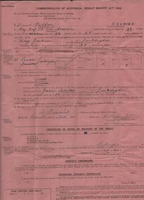
Document - ERROL BOVAIRD COLLECTION: WHEAT BOUNTY CLAIM
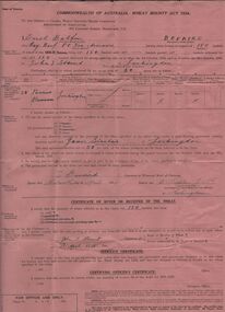
The John Bovaird Collection : Commonwealth of Australia Wheat Bounty Act 1934 State of Victoria Claim for Payment. By Errol Balfour Bovaird of May Reef PO via Avonmore. Regarding 150 bushels delivered for sale to John T Stewart of Lockington. Wheat produced on 50 acres : Allotment 25 Parish of Pannoo Bamawm. Dated 13/4/1935. Pink paper.agriculture, farm, wheat crop -
 Bendigo Historical Society Inc.
Document - ERROL BOVAIRD COLLECTION: WHEAT BOUNTY CLAIM
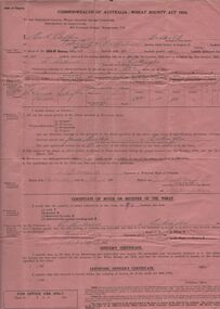
The John Bovaird Collection. Commonwealth of Australia Wheat Bounty Act 1934 State of Victoria Claim for Payment. By Errol Balfour Bovaird of May Reef PO via Avonmore. Regarding 96 bushels delivered for sale to R. Anderson of Lockington. Wheat produced on 50 acres : Allotment 25 Parish of Pannoo Bamawm. Dated 13/4/1935. Pink paper.agriculture, farm, wheat crop -
 Bendigo Historical Society Inc.
Document - ERROL BOVAIRD COLLECTION: WHEAT BOUNTY CLAIM
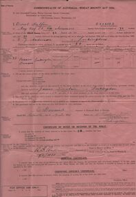
The John Bovaird Collection. Commonwealth of Australia Wheat Bounty Act 1934 State of Victoria Claim for Payment. By Errol Balfour Bovaird of May Reef PO via Avonmore. Regarding 96 bushels delivered for sale to R. G. Anderson of Lockington. Wheat produced on 50 acres : Allotment 25 Parish of Pannoo Bamawm. Dated 13/4/1935. Pink paper.agriculture, farm, wheat crop -
 Bendigo Historical Society Inc.
Document - ERROL BOVAIRD COLLECTION: WHEAT BOUNTY CLAIM
The John Bovaird Collection. Commonwealth of Australia Wheat Bounty Act 1934 State of Victoria Claim for Payment. By Errol Balfour Bovaird of May Reef PO via Avonmore. Regarding 96 bushels delivered for sale to Henry Jackson of Lockington. Wheat produced on 50 acres : Allotment 25 Parish of Pannoo Bamawm. Dated 13/4/1935. Pink paper.agriculture, farm, wheat crop -
 Whitehorse Historical Society Inc.
Document, Blackburn, 1/08/1995
Photocopy of Certificates of Title Vol 2105 Fol 420823 being 480 acres, part Crown Portions 81, 82, 89, 90, and 91 to Freehold Investment and Banking Co of Australia Limited, 9 January 1889. Includes plan of the area bounded by Central Road, Blackburn Road and Stanley Road, (now Wellington Avenue) Blackburn and transfers 1890 - 1926.land subdivision, central road, blackburn, blackburn road, gordon crescent, stanley grove, quarterman, martha, clarke street, grieve, robert, brown, james, game, kate, lincolne, phyllis marian, richardson, william wheeler, wellington avenue, thomas robinson -
 Bendigo Historical Society Inc.
Document - LANDS OFFICE, CROWN LANDS SURVEYED AND SOLD SANDHURST DISTRICT, 1854 (?) onwards
Document: buff colour hard cover journal. Contains details of crown lands surveyed and sold. On LH page, town, suburban or country lands. RH page: auction, selection, price per acre, price and purchaser. Indexed by parish in front page. Two front pages cut out. On spine ' Index book' ' Lands and Survey' '06' 'E' ' Country' and 'Sales'Lands Officeplace, land sales, bendigo, lands office, land surveyed, land sold, sandhurst -
 Bendigo Historical Society Inc.
Map - CAMPBELL COLLECTION: BENDIGO AND DISTRICT MAPS
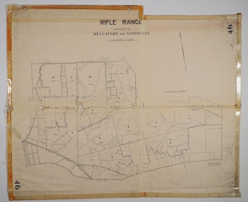
Map. Rifle Range, Parishes of Wellsford and Sandhurst. Scale 20 chains to 1 inch. Total area in plan is 5916 acres. Wallan and Bendigo Railway to Axedale Township and station 8 miles, to Longlea Railway Station 2 1/2 - 3 miles. Rifle Range. Compiled in W.P.B. from Assessment and Parish Plans, by H.A.D. 8-7-29H.A.D.(Darby).map, bendigo, allotments, bendigo rifle range, sandhurst parish, wellsford parish -
 Phillip Island and District Historical Society Inc.
Photograph Album, Kodak, Phillip Island Cemetery, c 1990
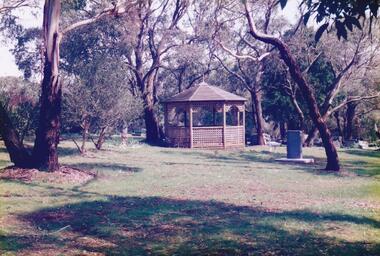
The Album was compiled by Nancy McHaffie late 1990's, with the assistance of Edith Jeffery's, with her book "Garden of Memories" and extensive knowledge of Phillip Island. The Cemetery lies back from the road and is surrounded by Manna Gums, rare Peppermint Gums, Blackwoods and other native trees. In all 25 acres of land were set aside as Crown Land in the land settlement of 1868. There are 6.2 acres of wetlands near the cemetery entrance. 6 Photographs of the Phillip Island Cemetery with views of the graves and the Gazebo.phillip island cemetery, nancy mchaffie, edith jeffrey -
 Phillip Island and District Historical Society Inc.
Photograph Album, Kodak, Phillip Island Cemetery, c 1990
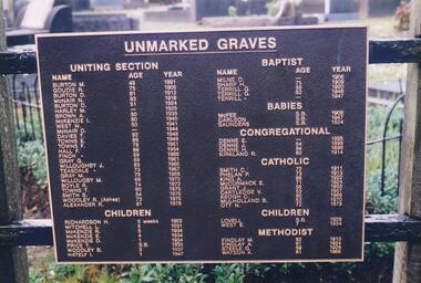
The Album was compiled by Nancy McHaffie late 1990's, with the assistance of Edith Jeffery's, with her book "Garden of Memories" and extensive knowledge of Phillip Island. The Cemetery lies back from the road and is surrounded by Manna Gums, rare Peppermint Gums, Blackwoods and other native trees. In all 25 acres of land were set aside as Crown Land in the land settlement of 1868. There are 6.2 acres of wetlands near the cemetery entrance.2 Photographs: 466-08 Notice of the Unmarked Graves. Although the land for the cemetery was granted in 1870, a survey was not made until 1903 hence the existence of unmarked graves. 466-09 A disastrous fire swept through the cemetery in 1943, destroying many structures around the graves - hence the rule "no wooden structures". the Hitching Posts were used for tying up hrses during a funeral service. They were erected in 1912 and now only two remain.phillip island cemetery, nancy mchaffie, edith jeffrey -
 Phillip Island and District Historical Society Inc.
Photograph Album, Kodak, Phillip Island Cemetery, c 1990
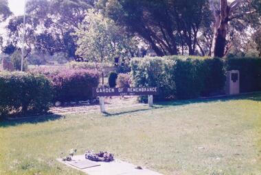
The Album was compiled by Nancy McHaffie late 1990's, with the assistance of Edith Jeffery's, with her book "Garden of Memories" and extensive knowledge of Phillip Island. The Cemetery lies back from the road and is surrounded by Manna Gums, rare Peppermint Gums, Blackwoods and other native trees. In all 25 acres of land were set aside as Crown Land in the land settlement of 1868. There are 6.2 acres of wetlands near the cemetery entrance.5 Photographs of the Garden of Remembrance. 466-10 - Garden of Remembrance sign 466-11 - On the 8th November 1990, two Life Members of the League, Mr Eddie Patton and Mr Ken Lang, planted a young seedling from the original Lone Pine from Gallipoli in the Memorial Garden 466-12 - The Returned Servicemens League placed a Flagpole and Granite Stone in the Memorial Garden in memory of the fallen 466-13 & 14 - Garden of Remembrance Plaquesphillip island cemetery, nancy mchaffie, edith jeffrey -
 Phillip Island and District Historical Society Inc.
Photograph Album, Kodak, Phillip Island Cemetery, c 1990
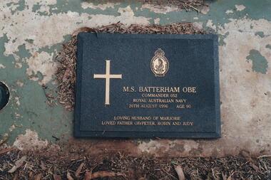
The Album was compiled by Nancy McHaffie late 1990's, with the assistance of Edith Jeffery's, with her book "Garden of Memories" and extensive knowledge of Phillip Island. The Cemetery lies back from the road and is surrounded by Manna Gums, rare Peppermint Gums, Blackwoods and other native trees. In all 25 acres of land were set aside as Crown Land in the land settlement of 1868. There are 6.2 acres of wetlands near the cemetery entrance.Lt. Commander M Batterham OBE RANVR was born in 1906 and later attended Geelong Grammar School. First attempt to join RAN was unsuccessful, due to health reasons. In 1942 he joined the Naval Volunteer Reserve. This was the beginning of a naval career which extended to peace-time in Canberra. He was awarded the OBE in 1952 for courage and devotion to duty. Maurice was laid to rest in the lawn section of the cenetery, August 1996 aged 90 years old.phillip island cemetery, nancy mchaffie, edith jeffrey -
 Phillip Island and District Historical Society Inc.
Photograph Album, Kodak, Phillip Island Cemetery, c 1990
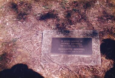
The Album was compiled by Nancy McHaffie late 1990's, with the assistance of Edith Jeffery's, with her book "Garden of Memories" and extensive knowledge of Phillip Island. The Cemetery lies back from the road and is surrounded by Manna Gums, rare Peppermint Gums, Blackwoods and other native trees. In all 25 acres of land were set aside as Crown Land in the land settlement of 1868. There are 6.2 acres of wetlands near the cemetery entrance.466-21: Henry Bennell was known as "Bricky" Bennell. Henry or Harry as he was sometimes called, was the Island's firs bricklayer. He was married to Elizabeth West, daughter of John West, who owned the first Chicory Kiln on the Island in what is now Thompson Avenue. Henry Died on September 14th, 1940, aged 68 years. 466-22: Captain David Reid J. B. Captain Reid served as a Councillor of the Phillip Island and Woolamai Shire in 1875. He was the first Trustee and President, as well as being instrumental in establishing a school at Rhyll on block 13 about 1870. He died in 1891 at the age of 75.phillip island cemetery, nancy mchaffie, edith jeffery