Showing 2119 items
matching bendigo maps
-
 Bendigo Historical Society Inc.
Map - GUIDE MAP OF BENDIGO & EAGLEHAWK, Late 1920's
... GUIDE MAP OF BENDIGO & EAGLEHAWK...Guide Map of Bendigo & Eaglehawk...Map. Guide map of Bendigo & Eaglehawk. Folded map... Inc. History House 11 Mackenzie Street Bendigo goldfields MAP ...Map. Guide map of Bendigo & Eaglehawk. Folded map of Bendigo & Eaglehawk with blue outer cover booklet. Map is compiled by E E Parker, Eaglehawk. Map shows tramways, bus routes and cost one shilling. Map shows Agricultural Showgrounds located between Park Street, Water Street, Barnard Street and Bridge Lane. Also shows Acclimitization Reserve located behind the Botanical Gardens at White Hills. Shows the location of Sailors Gully, Peg-Leg Gully, Jobs Gully, California Gully, Long Gully, Ironbark Gully, Golden Gully, Poverty Gully, Sheepshead Gully, Charcoal Gully, Eaglehawk Creek, Bendigo Creek and Back Creek.Contains interesting facts about Bendigo:- Area - 7,900 acres, Population - 26,000, First Council elected - 1855, Proclaimed a City - 1871. Gold Rush broke out - 1851. For first 10 years gold yield averaged 8,600 ozs. Per week. Total gold yield to 1923 - 572 tons valued at 82,000,000 pounds. Deepest mines - Victoria Quartz 4,614 ft., New Chum Railway 4,318 ft., 13 mines over 3,000ft. deep, 53 mines over 2,000 ft. deep. Sewering of City commenced 1922. All principal buildings now sewered. Map printed by Arnall & Jackson, General Printers, Stationers & Engravers, 476 Collins Street. Outer map blue cover printed in red and blue ink by J B Young, Lithographer. Map displays advertisement for Bendigo Timber Co. Outer blue cover displays advertisement for Campbell Connelly & Co. Pty. Ltd, Ironmongers, Timware Manufacturers, Plumbers, Sewerage Contractors, High and Forest Sts, Bendigo 9outside back cover) and for Hartleys ( J L Shoosmith) Bendigo, displaying Indian Motor Cycles (inside back cover).map, bendigo, township, guide map of bendigo & eaglehawk -
 Bendigo Historical Society Inc.
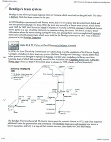
Document - LONG GULLY HISTORY GROUP COLLECTION: BENDIGO'S TRAM SYSTEM
... & 26, Map of Bendigo Tram routes 1972and 1996, Ballarat No 26... of Trams 24 & 26, Map of Bendigo Tram routes 1972and 1996, Ballarat ...Information on trams. Includes small photo of Trams 24 & 26, Map of Bendigo Tram routes 1972and 1996, Ballarat No 26 tram, S 164 tram, and No 38 tram. Mentioned is the individual history and where they can be found, operating and non operating trams, different classes of trams. Geelong's Birney Cars, two of which came to Bendigo and the Type G (Birney Safety Cars). Other information includes Nos, First introduced, Last withdrawn, Electrics (motors), Size and Seating/Crush Load. (8 pages).bendigo, history, long gully history group, the long gully history group - bendigo's tram system, battery trams, steam trams, electricity supply company of victoria, toastrack trams, david bromage, bendigo tramways, state electricity commission of victoria, the bendigo trust, chris brownbill, bendigo talking tram, david hoadley, prahran and malvern tramways trust, hawthorn tramways trust, fitzroy northcote and preston tramways trust, melbourne brunswick and coburg tramways trust, north melbourne electric tramway and lighting co, sydney tramway museum, tramway museum of victoria, railpage australia, ballarat vintage tramway, andrew cox, russell jones, australian electric transport museum, birney cars, j g brill & co, bob hawke, adelaide municipal tramways trust, tim blythman, bill winn, john radcliffe -
 Bendigo Historical Society Inc.
Map - BILL ASHMAN COLLECTION: MAP OF BENDIGO
... BILL ASHMAN COLLECTION: MAP OF BENDIGO... Map of Bendigo...Map of Bendigo. Contains street of Bendigo with Places... - Correspondence Map of Bendigo Cambridge Press A R McConnachie Bendigo ...Map of Bendigo. Contains street of Bendigo with Places of Interest marked, Map of the Bendigo Area with Places of Interest marked, and on the centre page is Bendigo the Golden Gateway to the North. There is a map with circles around Bendigo and their distance from centre Bendigo. Circles go to a distance of 20 miles. Information includes General Information, Scenic Attractions, Industrial Activities, Industries already Established, Sporting Facilities - Bendigo and District, and Cultural Organizations. JCI shield on the left under the map. Also some brief information about Bendigo.sciences, instruments - general, scalebuoy, bill ashman collection - correspondence, map of bendigo, cambridge press, a r mcconnachie, bendigo junior chamber of commerce, bendigo city council -
 Bendigo Historical Society Inc.
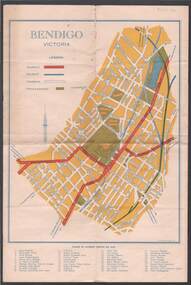
Document - PLAN OF TOWNSHIP OF SANDHURST 1854, July 25. 1854
... original 1854 bendigo map... - McIvor - Bull. Also shown on map: Bendigo Creek... PLACE Bendigo original 1854 bendigo map Lithographed at Surveyor ...Coloured- The planned township of Sandhurst is placed over the early Bendigo creek township of 1854. The two main streets of the early township were Camp and Auction streets. The street shown as Dowling street later became Queen & Hopetoun streets. The building near the bridge at View Point is Pykes Building. The Post Office was located here in 1854 - 58. Bernal street is now Chapel street. The creeks were straightened to their present courses. Streets on map are. Pall Mall - Bridge - McCrae - Hargraves - Lyttleton - Myers - Mollison - McLaren - Mitchell - Williamson - Mundy - Bernal - Baxter - Larritt - Bramble - McIvor - Bull. Also shown on map: Bendigo Creek - Government Reserve - Present Cemetery - Proposed diversion of creek. FH 562 Deframed 2022Lithographed at Surveyor Generals Office. Melbourne. July 25. 1854. By R. Meikle.place, bendigo, original 1854 bendigo map -
 Bendigo Historical Society Inc.
Map - BENDIGO, 1916
... Map. Bendigo, Gunbower, Gladstone, Talbot, Dalhousie... Inc. History House 11 Mackenzie Street Bendigo goldfields MAP ...Map. Bendigo, Gunbower, Gladstone, Talbot, Dalhousie, Rodney, Jarklan, Calivil, Hayanmi, Mitiamo, Wanurp, Pannoobamawm, Bamawm, Millewa, Ballendella, Janiember West, Janiember East, Pompapiel, Talambe, Dingee, Milloo, Pannoomilloo, Rochester West, Yarrayne, Salisbury, Yallook, Tandarra, Kamarooka, Warragamba, Diggorra, Minto, Bridgewater, Yarraberb, Neilborough, Whirrakee, Egerton, Elmore, Nolan, Goornong, Bagshot, Huntly, Derby, Leichardt, Nerring, Tarnagulla, Woodstock, Marong, Sandhurst, Wellsford, Bendigo, Axedale, Strathfieldsaye, Eppalock, Kimbolton, Lyell, Sedgwick, Mandurang, Lockwood, Ravenswood, Shelbourne, Laanecoorie. Price 3/-. Smaller map of State of Victoria. Lithographed at the Department of Lands and Survey, Melbourne. 1916. Scale : Two miles to one inch. Map was in book form. (number 62 in map cupboard 1)map, bendigo, bendigo -
Bendigo Historical Society Inc.
Map - MAP PORTION OF BENDIGO GOLDFIELD, Circa 1912
... MAP PORTION OF BENDIGO GOLDFIELD...Map: Portion of Bendigo Goldfield showing Sheepshead..., Sharebrokers, Bendigo and Eaglehawk. The map illustrates the main lines ...Map: Portion of Bendigo Goldfield showing Sheepshead, Deborah, Garden Gully, Paddy's Gully and Derby lines of reef. Showing statistical records of all the Companies on these lines. Issued by Wood and McNair, Sharebrokers, Bendigo and Eaglehawk. The map illustrates the main lines of reef as they appeared with mines and details of their calls and dividends as well as gold produced. Drawn by mining surveyor and geologist William Henry Cundy, who trained and worked for the Tasmanian Mines Department until 1893, when he moved and settled in Bendigo. Cundy was responsible for the surveying of the southern end of the field of Diamond Hill and beyond.topic, mining, companies, bendigo goldfield, sheepshead , deborah, garden gully, paddy's gully derby, wood and mcnair -
 Ballarat Tramway Museum
Pamphlet, Royal Historical Society of Victoria (Bendigo and District Branch), "Welcome to Bendigo" / "Evolution of Bendigo Tramways", 1960's
... safety cars. On rear has map of Bendigo, and a list of places... and 1947 Birney safety cars. On rear has map of Bendigo, and a list ...Four page, heavy manila coloured card - 200 gsm, scored and folded, sepia toned pamphlet titled "Welcome to Bendigo" / "Evolution of Bendigo Tramways". On front cover has a photo taken early 1960's of four trams at Charing Cross, the name of Bendigo, change of name from Sandhurst. Inside pages features 1890 Bendigo, 1903 California combination, 1945 Maximum Traction bogies, 1892 steam tram, 1913 open cross bench trams and 1947 Birney safety cars. On rear has map of Bendigo, and a list of places of interest. Has the crest of the City of Bendigo on the front cover.trams, tramways, bendigo, steam trams, battery trams -
 Bendigo Historical Society Inc.
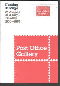
Book - NAMING BENDIGO: EVOLUTION OF A CITY'S IDENTITY 1836 TO1891
... Red and white covered booklet titled 'Naming Bendigo.... It has a sketch map of Bendigo and Golden Square in 1851. It has ...Red and white covered booklet titled 'Naming Bendigo evolution of a city's identity 1836 - 1891. It has a sketch map of Bendigo and Golden Square in 1851. It has a number of photos of early paintings, postcards and objects. The Foreword is written by Cr Rod Campbell, Mayor of the City of Greater Bendigo and the Introduction is written by Karen Quinlan, Director. The chapters are titled: Naming Bendigo evolution of a city's identity 1836 - 1891; The Gibson brothers soon renamed the run a popular choice in the 19th century; and to direct that the said place shall be called and known as Sandhurst; endeavoured to ascertain from what source, and at what time, the name of Bendigo arose: "The diggers...at Bendigo are recherché as to names;" and the Exhibition Checklist.event, exhibition, naming bendigo, naming bendigo - evolution of a city's identity 1836-1891, post office gallery, bendigo art galery, studio round, bambra, sandra bruce, karen quinlan, ian hill, national library of australia, city of greater bendigo, elaine harrington, vic lane, reg and judy macdonald, dennis o'hoy, sandhurst trustees, phil wilkins, darren wright, eaglehawk, eppalock, epsom, flora hill, golden square, kangaroo flat, strathfieldsaye, mount alexander run (north, or no 2 - ravenswood run -
 Bendigo Historical Society Inc.
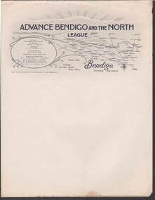
Document - CAMBRIDGE PRESS COLLECTION: LETTERHEAD - ADVANCE BENDIGO AND THE NORTH LEAGUE
... Advance Bendigo and the North League, Allan's Walk, Pall...? On the right it has a map showing Bendigo and a large area to the North ...Advance Bendigo and the North League, Allan's Walk, Pall Mall, Bendigo. Letterhead printed in dark blue and grey. At the top are sun rays above a cloud? On the right it has a map showing Bendigo and a large area to the North, North East and North West. On the left is an oval shape with the names of the Patron, His Worship the Mayor of Bendigo Cr. W. H. Taylor, President: Cr. G. D. Garvin, J.P., Vice-President W. Cowling, Esq, Executive Committee, Cr. J. Michelsen, J. L. Shoosmith, Cr. W. H. Taylor, J. Jeffrey, Dr. A. Beischer, C. L. Stilwell,A. L. Bolton O.B.E., W. Wallace, Lt. Col. G. V. Lansell, M.L.C.business, printers, cambridge press, cambridge press collection, advance bendigo and the north league, cr w h taylor, cr g d garvin j.p., w cowling, c m dawe, cr j michelsen, j l shoosmith, cr w h taylor, j jeffrey, dr a beischer, c l stillwell, a l bolton o.b.e., w wallace, lt col g v lansell m.l.c. -
 City of Greater Bendigo - Civic Collection
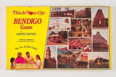
Leisure object - Board Game, E Systems Publications, This is Your City - Bendigo Game, 1985
... . Commercially printed with a full colour stylised map of Bendigo... printed with a full colour stylised map of Bendigo and Eaglehawk ...This limited edition board game was produced in conjunction with local businesses and attractions and sponsored by the Bendigo Development Committee. Supported by the five local municipalities (pre amalgamation) and both State and Local governments, the role of the Committee was to promote Bendigo's economic development. Boxed board game. Yellow box lid featuring photographs of popular sights around Bendigo on right side and a family playing the game on the left on lid. Inside box includes game board, playing cards, dice and game rules. 0345a; Fold out game board. Commercially printed with a full colour stylised map of Bendigo and Eaglehawk. 0345b Set of 96 Destination Cards single side printing on coloured card 0345c Set of 32 Surprise Cards 0345d Paper money 0345e Player tokens 0345f Set of dice 0345g Letter to Players re the board game and local businesses on 'Bendigo Premier Town' letterhead. 0345h Three printed pages of discount vouchers for local businesses. 0345i Game Rulescity of bendigo premier town 1982-85, city of bendigo commerce -
Bendigo Historical Society Inc.
Map - BENDIGO GOLDFIELD VERTICAL PROJECTIONS
... Map of Bendigo Gold Field in two sections showing 'vertical... of Victoria Map of Bendigo Gold Field in two sections showing ...Map of Bendigo Gold Field in two sections showing 'vertical projections along several anticlinal axial planes showing pitch, stratigraphical zones, faultlines, shafts and etc.'. Bulletin No 47 written top left hand side. Lines of reef described: Christmas line Lancashire line Nell Gwynne line New Chum line Hustlers line Garden Gully line Sheepshead line Mines along the reef lines are listed. This map forms part of the Geological Survey of Victoria, Structure of Bendigo Goldfield report, No. 47, 1923. H.Herman, late Director of Geological Survey. On bottom of second section : Prepared in the Geological Survey Office, Bendigo, under the direction of H. Herman, late Director of Geological Survey, from surveys by H.S. Whitelaw, Field Geologist, assisted by E.S. Usher, A.J.J. Moore and R.A. Keble.Geological Survey of Victoriabendigo, gold mining, reef lines -
 Bendigo Historical Society Inc.
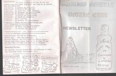
Document - JAMES LERK COLLECTION: BENDIGO CENTRAL BOTTLE CLUB NEWSLETTER
... Bendigo Central Bottle Club Newsletter - James Lerk... being once a main thoroughfare to Bendigo (with sketch map ...Bendigo Central Bottle Club Newsletter - James Lerk Collection (April 1976 by deduction). Reference to William Brude store owner/wine and spirit merchant. Involved in partnership in London Brewery and owned Norfolk Brewery - includes list of various bottles owned and used by William Bruce. Reference to Sheepwash being once a main thoroughfare to Bendigo (with sketch map) and information on two of the seven vineyards in area by 1855 - A. Derivan (sic) De Ravin and William Jones, Wine Merchant; article on Bendigo Breweries - reference in it to Albion Brewery, Phoenix Brewery (Pheonix sic), Lucan St Brewery, Thunder & Co, Thunders Sandhurst Brewery, A Thunder & Co, Tankard Malting Co, Bendigo Cognac Distilling Coy, Norfolk Brewery, BB Brewery, Union Brewery, Dublin Porter Brewery, Hindmarsh Brewery, Liverpool Brewery, Edinborough Brewery, Adelaide Brewery, the City Brewing Co, Anchor Brewing Co, Kent Brewery, Alpine Brewery, Sandhurst Brewery; Page listing know Bendigo aerated water manufacturers who used the Hamilton Patent - W Bruce, J Heffernam (sic) ,Hefferman?, G Pritchard, Hunter Bros, J Wharton, F G Beard, A Phillips, T Davies. -
 Bendigo Historical Society Inc.
Document - MCCOLL, RANKIN AND STANISTREET COLLECTION: INDENTURE BETWEEN KING EDWARD VIII AND MONUMENT HILL CONSOLIDATED MINE, 2/09/1936
... . Foolscap 4 pages including a map, dated 2nd September, 1936... of Monument Hill Consolidated (Bendigo) No Liability. Map drawn ...Indenture document number 10878, Vol 317 Folio 35044. Foolscap 4 pages including a map, dated 2nd September, 1936, between King Edward VIII (Crown land) and Monument Hill Consolidated (Bendigo) No Liability 'carrying on operations in the Parish of Sandhurst, to occupy and use the land demised as a site for machinery buildings and offices to be used in connexion with 'mining purposes' ' Document signed by Right Hon William Charles Arcedeckne, (Baron Huntingfield) and J. Stanistreet, Manager, affixed with the Common Seal of Monument Hill Consolidated (Bendigo) No Liability. Map drawn on dark buff paper, and fixed to document. Map shows lease 10878 in the Mining District of Bendigo, Parish of Sandhurst, County of Bendigo. N.Area 2.2.24 ( 2 acres, 2 roods, 24 perches ) Lease site on Rowan Street, bordered by Ophir Street. Coloured in purple on plan with small red area. On bottom: ' Note Red Areas Excised. Scale 4 chains to 1 inch, M.M. Var. 8 degrees 32' E. On lease site, New Chum Gully marked, W.B. House, and Permanent Occy. marked on red area. On last page ownership of lease details from 1937 to 1942.bendigo, mining, monument hill consolidated, common seal of monument hill consolidated, nell gwynne mine, south nell gwynne gold mining company, bendigo mine, ophir street, rowan street, mackenzie street.indenture vol 317 fol. 35044. j stanistreet. -
 Bendigo Historical Society Inc.
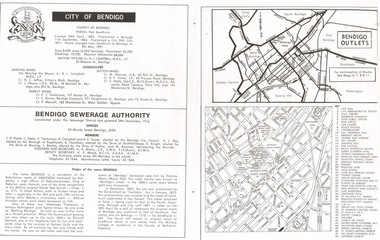
Document - LONG GULLY HISTORY GROUP COLLECTION: CITY OF BENDIGO
... of the name Bendigo. There is a small map of Bendigo Outlet roads... of the name Bendigo. There is a small map of Bendigo Outlet roads ...Page with the titled City of Bendigo includes when the County was created, proclaimed a Borough, then a City and a name change, the area, population, swellings and Mayoral Allowance. Darling Ward Councillors were: Cr R L Campbell, The Mayor, Cr N C Jeffrey, and Cr J Pearce. Sutton Ward Councillors, Cr M Petersen, Cr R F Turner, and Cr C Stoltz. and Barkly Ward Councillors, Cr P T Tomkinson, Cr C Davies and Cr P Mansell. Bendigo Sewerage Authority Members: T R Flood, C Stoltz, P Tomkinson, R Campbell, R F Turner, A L Roy, K Houlahan, E Knight, J Bowles, M Brennan, H A Moors and V F Moyle. Also mentioned is the Origin of the name Bendigo. There is a small map of Bendigo Outlet roads and another map with services, attractions, churches, etc.bendigo, history, long gully history group, the long gully history group - city of bendigo, cr r l campbell, cr n c jeffrey, cr j pearce, cr m petersen, cr r f turner, cr c stoltz, cr p t tomkinson, cr c davies, bendigo disposals, cr p mansell, bendigo sewerage authority, t r flood, bendigo city council, a l roy, borough of eaglehawk, k houlahan, shire of strathfieldsaye, e knight, shire of marong, j bowles, shire of huntly, m brennan, h a moors, v f moyle, abednego, john wesley, abednego thompson, battling bendigo, richard sherratt, thomas myers, castleton, sandhurst, military college of sandhurst england -
 Bendigo Historical Society Inc.
Ephemera - LYDIA CHANCELLOR COLLECTION: EPHEMERA
... dated 11-6-17. (VII) A small map of Bendigo for attendees... Independent Order of Rackebites map Bendigo airgraph hamper World War ...An assortment of ephemera in a plastic bag. (I) A handwritten list of concert items relating to W.W.I. (II) A Christmas gift card sent to the Pethard family. (III) Pte. W.H. Pethard A.I.F. Name tag. (IV) Lucerne post card with an unknown family message. (V) 2 empty envelopes. One has been sent from the front to Miss Lydia Pethard and has a censor stamp on it. (VI) A small cream sports meeting programme for the 2nd Aust. Inf. Brigade dated 11-6-17. (VII) A small map of Bendigo for attendees of the Independent Order of Rackabites Annual Conference held in Bendigo on March 13th to 16th, 1916. (VIII) An airgraph letter sent to Mrs. L. Chancellor from Wilf. Leech, RAAF Base, London 1944 thanking her for a hamper she sent him - through the ACF -the Australian Comforts Fund . (IX) An empty book titled 'Golden Square Methodist Girls Guild.' (X) A small brown 'Cole's Pocket Spelling Guide.'lydia chancellor, collection, ephemera, world war 1, entertainment, concert, music, australian infantry force, lucurne, post card, correspondence, communication, australian infantry brigade sports programme, independent order of rackebites, map, bendigo, airgraph, hamper, world war ii, australian comforts fund, spelling guide, education -
 Federation University Historical Collection
Book, Stanley B. Hunter, Memoirs of the Geological Survey of Victoria No 7., The Deep Leads of Victoria, 1909
... , Indigo, Morrison's Lead, Plans include: geological Map..., Indigo, Morrison's Lead, Plans include: geological Map ...Pink paper covered book by Stanley Hunter, Engineer in Charge of Boring Operations. Contents include tunnelling, deep sinking, the Chiltern Method, the Ballarat Method, Stawell, Ararat, Moyston, Raglan, Wimmera, Landsborough, Avoca, Ballarat West Leads, Berry-Moolort-Loddon Lead System, Clunes, Creswick, Bullarook Affluent, Corinella, Daylesford-Castlemaine Tributary, Majorca-Carisbrook tributary, Huntly, Coliban, Campaspe, Rutherglen., Smythesdale, Durham Lead, Tanjil, Evolution of Mining Machinery, size of claims, Definition of a Deep Lead, Discovery of Gold in Victoria, Geographical Position of Deep Leads, Water in Deep Leads, Methods of Deep Lead Mining, Cost of Deep Lead Mining, Stawell, Ararat, Moyston, Raglan, Wimmera, Landsborough, Avoca, Ballarat West, Berry, Springs Hill, Loddon Valley, Charlotte Plains, , Timor, Burn Creek, Huntly, Colinan, Goulburn, Ovens Valley, Chiltern, Indigo, Morrison's Lead, Plans include: geological Map of Stawell, ararat, Raglan and Landsborough; Kempson's Freehold Mine, Stawell; Geological Map of Beaufort, Avoca, Maryborough, Ballarat west, Berry-Moolort, Loddon, Creswick, Marong, &c; Cardigan Propriety Gold Mine; Working Miners United Gold Mine, Homebush; Hepburn Deep Lead Plan; Madame Berry West Mine; West Berry Consols Mine; Spring Hill and Central Leads; Berry Consols Extended Mine; Loddon Valley Goldfields; Chalk's No 3 Mine; Charlotte Plains Considated Mine; Duke United Mine; Geological Map of Bendigo, Huntley, Campaspe, Malmsbury, Kyneton, trentham, &c; Geological Map of Chiltern, Rutherglan, Eldorado, Beechworth, &c; Chiltern Valley Gold Mine; Wallace Chiltern Valley Consols Mine; great Southern and Chiltern Valley United Mine; great Northern extended Consols; Prentice and Southern deep Leads; Glenfine South Gold Mine; Geological map of Pitfield, Rokewood, Mt Mercer, Ballark, Meredith, &c.; McEvoy Mine; Dargo . . . . . . . . . . . . . . . . . . . . . . . mining, deep leads, squire, tools, gold panning, gold cradle, cradling, puddling, tubbing, mining shaft, shaft sinking, whip, horse whip, whim, horse whim, chalk's no. 1 mine, maryborough, mining cage, shaft, mining trucks, maryborough, washdirt, puddler, tunnelling, deep sinking, chiltern method of working, ballarat method of working, sampling washdirt. gravels, balmoral, mt william, stawell, moyston, great western, ararat, raglan, wimmera valley, landsborough, cardigan, haddon, beaufort, waterloo, avoca, lamplough, caralulup, ballarat west, ballarat, smythesdale, glenfine, illabarook, durham lead, morrison's lead, bullengarook, berry-moolort-loddon system, clunes, creswick, spring hill, bullarook, castlemaine - daylesford, majorca, carisbrook, timor, burnt creek tributary, tarnagulla, marong, rheola, inglewood, huntly, coliban, campaspe, goulburn lead system, ovens valley system, mitta mitta, kiewa valley, tarago, tanjil, moondarra, bogong, dargo high plains -
 Ballarat Tramway Museum
Magazine, Australian Electric Traction Association (AETA), "The Trolley Wire", Vol 1, No. 3, "The Trolley Wire", Vol 1, No. 4, "The Trolley Wire", Vol 1, No. 7, "The Trolley Wire", Vol 1, No. 8, "The Trolley Wire", Vol 1, No. 10, 1952
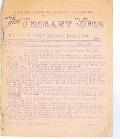
... of tramway power for pumping stations, map of Bendigo (see image i4... History Sydney Newcastle Broken Hill Brisbane Ballarat Bendigo Map ...5685.1 - Spirit duplicated magazine, 4 quarto pages, single sided - " The Trolley Wire", Vol 1, No. 3, April 1952, stapled down along the left hand side. Has items on Sydney trams, a Map of Ballarat tramways (See image i2), Newcastle News, and a discussion of the influx of transport experts into Sydney from England. 5685.2 - Spirit duplicated magazine, 7 quarto pages, single sided - " The Trolley Wire", Vol 1, No. 4, May 1952, stapled down along the left hand side. Has notes on use of tramway power for pumping stations, map of Bendigo (see image i4), news from Brisbane, Sydney news, association news, tramcar painting letters, Newcastle Destination roll 5685.3 - Spirit duplicated magazine, 7 quarto pages, single sided - " The Trolley Wire", Vol 1, No. 7, August 1952, stapled down along the left hand side. Has notes on Brisbane, Association news, map of the La Perouse - Botany - Mascot district, Ryde Cemetery, Sydney R 1890 runaway, North Sydney destination roll (1910) 5685.4 - Spirit duplicated magazine, 8 quarto pages, single sided - " The Trolley Wire", Vol 1, No. 8, September 1952, stapled down along the left hand side. Has notes on Association news, (left hand side very faded), map of the Enfield's lines, Brisbane Trolley Bus system 1952, Sydney news, and Eastern Suburbs roll. 5285.5 - Spirit duplicated magazine, 9 quarto pages, single sided - " The Trolley Wire", Vol 1, No. 10, November 1952, stapled down along the left hand side. Has notes on Brisbane, Wylde St trolley bus route in Sydney, Sydney news, association notes, Proposed lines in Sydney - Haberfield to Dobroyd, use of triple trams in Sydney, Broken Hill destination roll, Fort Macquarie depot track drawing and Newcastle news. See Reg Item 5685 for other Vol 1 issues and Reg Item 5686 for Vol. 2 issues.Vol 1, No. 4 has pencil inscription of "H. H. Matthews" in top right hand corner.trams, tramways, tramway news, history, sydney, newcastle, broken hill, brisbane, ballarat, bendigo, map -
 Bendigo Historical Society Inc.
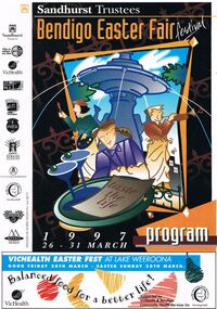
Document - BENDIGO EASTER FAIR FESTIVAL PROGRAM 1997, 26 March 1997
... Bendigo Ministers' Fellowship. Map of CBD Advertisements.... Sunrise Church Service, Bendigo Ministers' Fellowship. Map of CBD.... Sunrise Church Service, Bendigo Ministers' Fellowship. Map of CBD ...Bendigo Easter Fair Festival Program, 26-31 March, 1997. Festival Features, Evening of Art & Classical Music, Rotary Club of Bendigo. VicHealth Easter Fest, Victorian Health Promotion Foundation & Bendigo Community Health Services. Fine Food Fest. Free Stage. Free Evening Concert & Fireworks, Zaire. Torchlight Procession, sponsored by Prime TV & Coca Cola, Bendigo Market Place. Fireworks Spectacular, Sponsored by Bendigo Market Place & Prime TV. Street Fiesta, sponsored by Arts Victoria. Street Extravaganza, Coca Cola Carnival, Sponsored by Coca Cola. Star for a Day, Power Audio Visual & Prime Television. Handcraft Bazaar, Rotary Club of Bendigo Sandhurst Art & Craft Market. Cosmopolitan Street Café, Arts Victoria. Awakening of the Dragon, Bendigo Chinese Association. Gala Parade, Prime Television & Coca Cola. Firewalking by the Australian Skeptics, Discovery Science & Technology Centre. Up In Flames, Discovery Science & Technology Centre. Barry Kenny's Country Roundup, Nadort Promotions. School's Day. Teddy Bear's Picnic, Dragon City Marshals. Fire Brigades Children's Carnival. Family Event, Bendigo Minister's Fellowship. Bendigo Easter Antique Fair. Historic Photographic Exhibition, Burt Sargent Circa 1900. Open Garden at Nanga Gnulle (''nanga nully''). A parade of Quilts, Strathdale Bendigo Quilters Inc. Tasting the Life, Gail Tavener Studio. Snakes Alive Dangerous Australians, BRIT. Y's Men's Club of Bendigo Book Fair, YMCA. Bendigo Camera Club, BRIT. Bendigo Woodcraft Exhibition, Woodturners Bendigo Inc. Autumn Bonsai, Bendigo Bonsai Club. Convocation, National Trust Bendigo. Arms & Collectables, Golden City Collectors Assoc. In. Rotary Art Show. Rotary Pottery Exhibition. Women's Vision For The Church, Provincial Council of Mothers Union. Historic Toorak House, Lioness Club of Golden City Bendigo. White Hills Cemetery. Bendigo Cemetery. Festival of Flowers, Craft & Garden, Bendigo Jockey Club. Shannons Corporation Motorfest, City Drive Through, Static Display, Motorkhana, Time Trial. Bendigo Bank Dragon Mile. Volkswagen Car Show, a part of the 28th National Bug-In. Repco Cycles, Australian Veteran Cycling Council Inc. Championships. Under 17 Australian Badminton Championships. Palm Sunday, Bendigo Symphony Orchestra. Way of the Cross, Bendigo's Combined Churches. The Easter Story, Kangfluca Music. Sunrise Church Service, Bendigo Ministers' Fellowship. Map of CBD Advertisements: Bendigo Easter Antique Fair. Austar. Bendigo Art Gallery. Bendigo Visitor Information Centre. Prime. Golden Dragon Museum Inc. Bendigo Heritage Tours. Discovery Science & Technology Centre Bendigo. Sponsors: Sandhurst Trustees, Prime, Vic Health, ABC Radio, Arts Victoria, Coca Cola, Events Bendigo, City Of Greater Bendigo, Bendigo Community Health Services, Shannons., Morris Design PH 5448 8777Morris Designevent, easter fair, bendigo easter fair, bendigo easter fair festival program, 26-31 march, 1997. festival features, evening of art & classical music, easter fest, . fine food fest. free stage. free evening concert & fireworks. torchlight procession. fireworks spectacular, street fiesta, street extravaganza, coca cola carnival, star for a day, handcraft bazaar, art & craft market. cosmopolitan street café, awakening of the dragon. gala parade, firewalking australian skeptics, discovery science & technology centre. up in flames, barry kenny's country roundup, nadort promotions. school's day. teddy bear's picnic, fire brigades children's carnival. family event, bendigo minister's fellowship. antique fair. photographic exhibition, burt sargent circa 1900. open garden nanga gnulle a parade of quilts, strathdale bendigo quilters inc. tasting the life, gail tavener studio. snakes alive dangerous australians, brit. book fair, ymca. bendigo camera club, brit. bendigo woodcraft exhibition, woodturners bendigo inc. autumn bonsai, bendigo bonsai club. convocation, national trust bendigo. arms & collectables, golden city collectors assoc. art show. pottery exhibition. women's vision for the church, provincial council of mothers union. historic toorak house, lioness club. white hills cemetery. bendigo cemetery. festival of flowers, craft & garden, bendigo jockey club. motorfest, drive through, static display, motorkhana, time trial. dragon mile. volkswagen car show, national bug-in. repco cycles, australian veteran cycling council inc. championships. under 17 australian badminton championships. palm sunday, bendigo symphony orchestra. way of the cross, bendigo's combined churches. the easter story, kangfluca music. sunrise church service, bendigo ministers' fellowship. map of cbd advertisements: antique fair. golden dragon museum inc. bendigo heritage tours. discovery science & technology centre bendigo. sponsors: sandhurst trustees, vic health, abc radio, arts victoria, coca cola, events bendigo, city of greater bendigo, bendigo community health services, shannons., morris design. prime tv. austar. bendigo art gallery. bendigo visitor information centre. prime, victorian health promotion foundation, zaire, sponsored by bendigo market place & prime tv, sponsored by arts victoria, sponsored coca cola, power audio visual, rotary club of bendigo sandhurst, bendigo chinese association, y's men's club of bendigo -
 Bendigo Military Museum
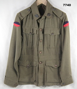
Uniform - JACKET, BATTLE DRESS - ARMY, Australian Defence Industries, 1942
Jacket - Khaki colour wool serge fabric. Battle Dress style with belt at waist. Brown metal buttons with shank and split pin. Buttons have raised emblem - map of Australa and Crown and lettering "AUSTRALIAN MILITARY FORCES". Collar, shoulder epaulettes, four front pockets with button down flaps, sleeve cuffs. Unit colour patch insignia - handmade purple over red - 38th Battalion. Collar badges - metal - Rising Sun Badge. Shoulder epaulettes - metal "AUSTRALIA" badge. Manufacturers white cotton fabric label - inside right pocket.Manufacturers information on two labels. Black ink print - "REGIMENTAL NO./NAME" Red ink print - "V162/ MADE IN/ AUSTRALIA/ 1942/ size". Handwritten black ink pen "XXX/ 20X" uniform, army, battle dress, ww2 -
 Bendigo Military Museum
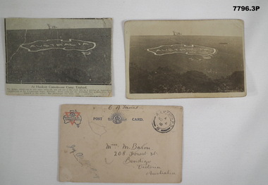
Postcard - POSTCARD - HURDCOTT, AIF CAMP, UK, R. H. Baron, 3. 3/11/1918
Cards relate to R.H. Baron's time at Hurdcott AIF Camp during 1918. Part of the "Robert H. Baron", No. 3596, and Cooper Collection. See Catalogue No. 1981P for details of Baron's service.1. Black and white newspaper clipping pasted onto a piece of cream card. Clipping features a black and white photograph of a map of Australia carved into the side of a hill. Caption in black type below photograph. 2. Black and white postcard style photograph of a map of Australia carved into the side of a hill. 3. Plain cream coloured postcard with YMCA logo and AIF insignia at the top. Handwritten address on front and handwritten letter on back.1. Handwritten in black ink on back: 'This map has been cut in the hill and is only about 10 minutes walk from here, Bob' 3. Handwritten in black ink on front: 'Miss M. Baron, 208 Forest St. Bendigo, Victoria, Australia'. Stamped in black on top R.H.C. of front: 'Postmark - AIF Camp P.O. No.4, 18,' Handwritten in black ink on back: 'Letter to R.H. Baron's sister Myrtle from Hurdcott Camp dated 3.11.18.'robert h. baron, cooper collection, postcards, hurdcott aif camp -
 Bendigo Military Museum
Administrative record - 1 Fd Svy Sqn Project Report - Operation Carto Mercury 1986, 28 Jan 1986
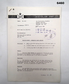
Operation Carto Mercury was a field completion Operation mounted by 1 Fd Svy Sqn 11 Aug 1985 to field complete 4 x 1:25000 compiled map sheet in the Cabarlah area to the North of Tawoomba. Included maps: 9243 - 23 Kingsthorpe, 9243 -24 Goombungee, 9243 - 21 Gomaren Creek, 9243 - 22 High FieldsA4 Typed document and diagrams, 14 pages. Report produced by 1 Fd Svy Sqn 1986royal australian survey corps, rasvy, fortuna, army survey regiment, army svy regt, asr, 1 fd svy sqn -
 Bendigo Military Museum
Administrative record - Geodetic Survey and Topographical Mapping in Australia - Report by BP Lambert 1968, 1968
Australia is governed by a Federal Government and by six State Governments. National coordination of their respective geodetic survey and topographic mapping activities is effected on the advice of a National Mapping Council. Twenty years ago, at least 95% of Australia was poorly mapped and what maps existed were in need of revision. only a small area of the continent was covered by horizontal geodetic control and there was no scheme for a national levelling survey. Over the intervening period there has been an urgent and increasing demand for topographic maps varying from large scale contoured maps in support of specific engineering projects to rapid reconnaissance maps required for mineral prospecting in remote areas. Superimposed on this has been a defence requirement, specifically for military training areas, and generally for maps of the whole country. During the period much progress has been made. This paper reports on the progress from early colonial days through to the present time and finally hazards a prediction of future trends.Photocopy of 18-page typed report including diagrams, stapled top left-hand corner. Geodetic Survey and Topographic Mapping a Report by BP Lambert Director of National Mapping, Department of National Development, Canberra, Australia, 1968.royal australian survey corps, rasvy, fortuna, army survey regiment, army svy regt, asr, national mapping -
 Bendigo Military Museum
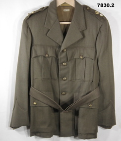
Uniform - JACKET, SERVICE DRESS, ARMY
1. Jacket - khaki colour wool/polyester fabric Service dress style with belt. Buttons - dull gold coloured metal with shank with raised emblem and lettering. Crown, map of Australia and "AUSTRALIAN MILITARY FORCES". Collar, shoulder epaulettes with three metal rank insignia pips. Gold and red crown, officer pip, Letter "R" = Lieutenant Colonel Retired. Four front pockets - top patch pockets with button closure flap. Lower - inset pockets with button closure flap. Khaki colour cotton sateen fabric lining body of jacket, brown strip lining to sleeves. White cotton manufacturers label on lining inside below collar. 2. Belt - khaki colour wool/polyester fabric service dress style. Copper colour metal buckle with two pins. Leather belt keepers and brown plastic buttons.Manufacturers information on label - dark brown ink print. 1. "M.TX".uniform, army, service dress -
 Bendigo Military Museum
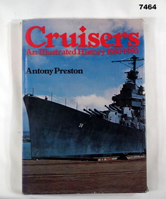
Book - BOOK, NAVAL, Antony PRESTON, "Cruisers- An Illustrated History 1880 -1980", 1980
Hard cover book with dust cover. Hard cover - cardboard with Navy Blue buckram cover. Gold print on spine. Dust cover - paper, red and black print on front, spine, front and back flaps. Illustrated, front cover photograph in colour of a ship dockside. Back cover - photograph in colour of a portion of a ship in a seascape of water, sand and trees in background. 191 pages, cut, plain, white paper. Illustrated in black and white and colour photographs, maps and technical illustrations. Front end paper - handwritten greeting.Front endpaper - blue pen - handwritten, "TO DAD/ FROM VALERIE & IAN - FATHERS DAY 1981". books, navy cruisers -
 Bendigo Military Museum
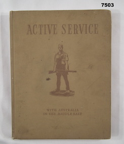
Book - BOOK, WW2, The Military History & Information Section AIF (Middle East), "ACTIVE SERVICE WITH AUSTRALIA IN THE MIDDLE EAST", 1941
Refer Cat No. 7504, 7505, 7506, 4 book collection.Hardcover book. Cover - cardboard, with light brown buckram cover with dark brown print on front and spine. Illustration in dark brown - soldier in silhouette. End papers - illustrated brown and cream colour tones - maps back and front, 128 pages - cut, plain, cream colour paper, illustrated colour, black and white and sepia illustrations, photographs, paintings.books, army, ww2 -
 Bendigo Military Museum
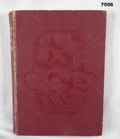
Book - BOOK, WW2, The Sun News - Pictorial, "THE FOURTH YEAR OF WAR IN PICTURES", 1944
Refer Cat No. 7503, 7504, 7505, 4 book collection.Hard cover book. Cover - cardboard, with red colour buckram cover, gold print on spine and embossed illustrations on front cover depicting map, aircraft and tank. End papers - illustrated, sepia tones artwork with aircraft and landscape battle scene. 255 pages - cut, plain, white paper. Illustrated in black and white photographs, maps and battle diagrams. Handwritten inscription on page opposite Title Page.Page opposite Title Page - handwritten black ink inscription - "Wishing Kevin a/ Merry Xmas/ from/ Nathalie 1944".books, pictorial, ww2. -
 Bendigo Military Museum
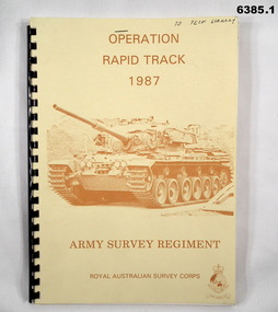
Administrative record - Army Survey Regiment - Operation Rapid Track 1987 Operation Report, Army Survey Regiment, Bendigo, 27 May 1987
The Survey Operation Report deals with the cartographic completion of four 1:50,000 topographical line maps and one Special 1:50,000 map covering the Puckapunyal Military Training Area. The report covers in detail the digital stereo plotting, field completion (checking) and the cartographic completion including printing. The four 1:50.000 maps are 7823-1 PYALONG, 7824-2 COSTERFIELD, 7923-4 TALLAROOK and 7924-3 NAGAMBIE. Annex A lists personnel and dates involved and is attached as 6385.2. Annex B lists the members of the field completion parties.A4 sized buff coloured light cardboard covered report, plastic spiral binding. Front cover includes text, Survey Corps badge and light brown image of a Centurian tank. "To Tech Library", Page 2 has two small handwritten notes indicating that Phase 2 was the Field Completion Phaseroyal australian survey corps, rasvy, fortuna, army survey regiment, army svy regt, asr -
 Bendigo Military Museum
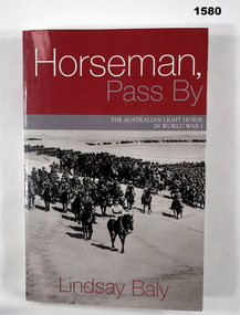
Book - BOOK, WW1, Lindsay Baly, "Horseman, Pass By", 2003
"Horseman, Pass By. The Australian Light Horse in World War 1".Soft cover book. Cover - cardboard, white, red and grey colour print on front, spine and back. Front and back covers illustrated black and white photograph, a mounted division (of soldiers on horseback) march out. 337 pages, cut, plain white paper. Illustrated in black and white photographs, maps and diagrams.books, ww1, light horse -
 Bendigo Military Museum
Map - Australian Topographical Survey NAGAMBIE SW Sheet, 1 inch:1 Mile, NW portion Plane Table Field sheet 1921, Australian Survey Corps, 1921
This is a coloured reproduction print of an original Plane Table compilation map sheet of Nagambie area 1inch to 1 Mile scale compiled by Sgt Jack Cullen Australian Survey Corps 30 September 1921. Jack was one of the foundation members of the Australian Survey Corps. Of particular interest is the fact that this is a heighted compilation with contouring (required for Military use) as many early maps were purely planimetric. A table on the right hand side details the number of days that it took to produce the compilation. The reverse side of this print is a copy of the Tallarook plane table South East field sheet.Reprinted coloured Image of Australian Topographical Survey NAGAMBIE SW Sheet,1 inch:1 Mile, NW portion hand drawn Plane Table Field sheet. Includes an itemized summary of work, signed by Sgt J Cullen Australian Survey Corps September1921.royal australian survey corps, rasvy, fortuna, army survey regiment, army svy regt, asr -
 Bendigo Military Museum
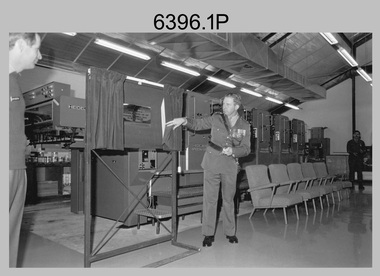
Photograph - Wayzgoose Hall and Speedmaster Printing Press Commissioning, Army Survey Regiment, Fortuna Villa, Bendigo, 1990
The first photograph was probably taken at a media event announcing the introduction of the Heidelberg Speedmaster printing press in late 1990. LTCOL Rene van den Tol was the CO of the Army Survey Regiment from 1989 to 1991. Partly obscured behind the CO was Mr Bruce Reid, who was the newly elected federal member for Bendigo. The media event was held in Wayzgoose Hall, Lithographic Squadron’s new purpose-built building constructed to house the Speedmaster printing press. This occasion is covered in more detail in page 143 of Valerie Lovejoy’s book 'Mapmakers of Fortuna – A history of the Army Survey Regiment’ ISBN: 0-646-42120-4. Refer to Item 6291.6P for more photos of the Open Day.This set of three photographs were taken at the commissioning ceremony of Wayzgoose Hall, the Army Survey Regiment’s new printing building and the Heidelberg Speedmaster Printing Press, at Fortuna Bendigo on Wednesday 27th June 1990. The black & white photographs were printed on photographic paper and are part of the Army Survey Regiment’s Collection. The photographs were scanned at 300 dpi. .1) - Photo, black & white, 1990. Commissioning Ceremony L to R: CO LTCOL Rene van den Tol, Commander 3rd Military District BRIG P. Davies AM ADC, WO2 Jeff Willey in background. .2) - Photo, black & white, 1990. L to R: CO LTCOL Rene van den Tol, Commander 3rd Military District BRIG P. Davies AM ADC with first printed topographic map – 8123 4 Mansfield 1:50 000. .3) - Photo, black & white, 1990. L to R: SGT Gary Kerr in background, Seligson Claire Printing Press Suppliers - Richard Rasmussen and Oliver Holliwell, Bob Martin, Director of Survey COL Don Swiney MBE, RA Svy COL CMDT COL John Hillier, Commander 3rd Military District BRIG P. Davies AM ADC, Bruce Reid Bendigo MHR..1P to .3P – Annotated on back of photos ‘Opening New Print Room BRIG Davies 27 Jun 90’. Personnel and civilians are identified.royal australian survey corps, rasvy, army survey regiment, army svy regt, fortuna, asr, litho