Showing 314 items matching "dray"
-
 Glenelg Shire Council Cultural Collection
Photograph - Sheet of 10 contact prints - Various Portland historic buildings and landmarks, c. 1970
Sheet of 10 contact prints of rephotographed photographs. Identifying numbers 5715a, b, c, d, e, f, g, h, i, j (a) Portland form Battery Point (b) Henty Beach, looking south (c) Palmer Street Primary School, No. 489 (d) Guardian Office, Bentinck Street (e) Railway Station Harbour Baths Bentinck Street (f) Jane Henty - wife of Stephen (g) bullock dray, bush (h) Ocean Pier (i) Bentinck Street Percy Street (j) Henty BeachFront: (a) Portland from Battery Point. - The Rose Series (c) .... School, Portland Vic. - Toys Photo (d) Bentinck Street The Guardian Office Portland. - Magnus Photo (e) Railway Harbour & Jetty (f) Price $3.70 (i) Bentinck Street Percy Street The Harbour and Town of Portland (j) Henty Beach, Portland -
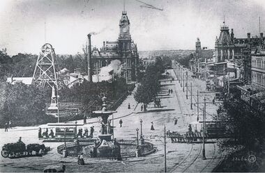 Bendigo Historical Society Inc.
Postcard - CHARING CROSS, VALENTINE POSTCARD,1910
B+W photo of Charing cross from a 'Valentine' postcard photograph c1910 (details J. Lerk) streetscape from elevated position looking from Charing Cross down Pall Mall towards White Hills. Depicts: Alexandra fountain; electric tram; horse drawn wagon, dray, vehicles; Hustlers Royal reserve No2 mine, poppet heads, chimney; post office; tram power poles; buildings fronting Pall Mall; Pedestrians; trees; Queen Victoria statue; Colonial bank. Inscription: Lower right '53464 JV'.place, bendigo, view over alexandra fountain -
 Bendigo Historical Society Inc.
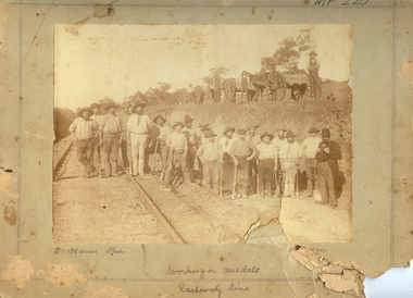
Photograph - HARRIS COLLECTION: WORKMEN ON AXEDALE RAILWAY LINE
Sepia photograph on grey board with double pencil line border. Group of eighteen men with picks standing in shallow cutting with railway line at L. On top of cutting four horse drawn drays with five standing nearby. Inscriptions: Hand written in pencil under image 'D Harris Photo' ( David Harris, son of Jonathan and Harriet Harris, Axedale) 'Working on Axedale Railway line, 'Axedale'. On back circular stamp 'Royal Historical Society of Victoria, Bendigo Branch', '1959', '59'm 'Duplicate copy'. History: Prev. Acc. No. MP220.D Harris Axedaleperson, group, males, see also 2001.265.01 -
 University of Melbourne, Burnley Campus Archives
Newspaper - Newspaper Cutting, The Leader, Woman Students at Burnley School of Horticulture, 1941
Cutting from The Leader, March 29, 1941. Includes six photos of students working at Burnley. Captions are: (1) "Miss C. Allen working with a microscope in the classroom." (2)"A ride back to the college buildings in a dray is much more fun than walking." (3) "Miss Margaret Bowron with a pumpkin grown in the vegetable garden." (4) "The theoretical side of horticulture, is too, important - and interesting, to judge by the expression on the faces of these students." (5). "Miss Joan Hamborg disbudding begonias." (6)"Miss Joan Harrison is here seen among the rhubarb in the vegetable garden."the leader, c. allen, margaret bowron, microscope, cynthia allen, joan harrison, vegetables, rhubarb, orchard, students working outside, students in class, pumpkins, begonias -
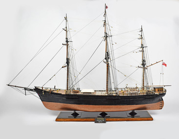 National Wool Museum
Decorative object - Model Ship, David Lumsden, Lightning, 2020
In the early nineteenth century larger Australian wool producers sent all their wool by sailing ship to London, where colonial auctions were held in November, January, February and March. Wool bales were carried from the farm on drays or wagons pulled by bullocks, horses or camels to port warehouses. In these times, wool transport could take anything from a week to six months. Ships, such as the Lightning, were then loaded and raced each other to get to London ahead of their rivals. The wooden ship 'Lightning' was destroyed by fire while loading wool at Geelong 31 Oct. 1869. Scuttled in Corio Bay and the remains later blown up. Reputed to be one of the fastest sailing ships. Famous in the Australian passenger trade.Model of a clipper ship with hull painted brown and black. Red Ensign flag attached to flag pole.On label - Lightning Black Ball Line 1854-55geelong, transport, model ship, lightning, wool transport -
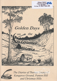 Eltham District Historical Society Inc
Book, Golden Days on the Caledonian Diggings: the diaries of Thomas Young of Kangaroo Ground, Panton Hill and Christmas Hills, compiled by Mick Woiwod, 2005
The original diaries, (1859-1866,1895-1900) of Thomas Young discovered by a Young descendant have been transcribed with the author adding his own research and historical photographs. The diary sheds light on the lives of prospectors who worked the Caledonian goldfields in the 1860s, including St Andrews and Smiths Gully. Thomas Young, migrated from Scotland and moved to the goldfields in 1858. He carted ore by horse and dray from mines around St Andrews to crushers in Panton Hill and Smiths Gully. He later became a baker. He and his wife Bridget had eleven children. He later settled at Christmas Hills establishing the local store and school. See also: "Old Diary Strikes Old" by Natalie Birch, Diamond Valley Leader August 17 2005The diary provides a rare first-hand account of life on the Caledonian goldfields.v. : ill. 69 p 30 cm[written inside front cover] To my very good friend Harry Gilham - Mick Woiwod 25th August 2005thomas young, caledonian gold fields, kangaroo ground, christmas hills, panton hill, smiths gully, st andrews, diary, gold mining -
 Eltham District Historical Society Inc
Book, Jenny Brown et al, Out of the Mist; Osborne Peninsula, 2024
The Osborne Peninsula on the Yarra River at Warrandyte accommodates a limited number of properties and residents (70 households). The area is rich in geology and ecology, and an unusually rich endowment of human, built and creative history. Contents: Welcome: The landform: The River: Aboriginal occupation: The Miners: North Warrandyte :The Subdivision: The Lowes: The Osbornes: The Last Osborne: The Elders: The Relics: Dray Track: Water Wheel"Kauri Plaque: River track: Pines: Windmill Creek Bridge: The Koornong School: The Houses" Man Cave: MidCentury Classic: Enduring Original" Masterwork: The Muddies: The State Park: The Saving of Koornong Reserve: The Landcare Story: Flora and Fauna: The Vulnerable, Endangered and threatened: Birds: Mammals: "Waring" the wombat: Reptiles: Fish: Invertebrates: Flora: Fire. Published by the North Warrandyte (Osborne Peninsula) Landcare Group. Includes photos from EDHS collection.64 p. : ill., map ; 29.7 x 21 cm. (2 copies)yarra river, birrarung, dray track, fauna, geology, houses, indigenous history, koornong reserve, koornong school, lowe family, mining, mudbrick houses, north warrandyte, osborne family, warrandyte state park, water wheel, north warrandyte (osborne peninsula) landcare group, osborne peninsula -
 Wodonga & District Historical Society Inc
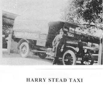
Photograph - Harry Stead Taxi Service
Harry Stead, Snr., owned and operated Wodonga’s first taxi service. He had horse drawn cabs running between Wodonga, and Albury in 1868. He also ran a carrying business with wagons and drays. Workmen from Albury and Wodonga were carried to the construction site of the Hume Weir. Drays, although slow, were used with room for 10 or 12 paying passengers, at times. Stead’s paddocks ran back from Sydney Street (now High Street) with stable accommodation for his 70 and more horses. The Provincial Motel occupied part of the site in later years. Harry’s son, “young Harry” joined his Dad around 1892 as soon as his schooldays were over. After the horse drawn cabs, the Steads began a motorised taxi, hire car and bus services. Some of the taxis used were an A-Model Ford, 1934 Ford, Ford V8, Dodge Tourer, Hudson Six and, earlier, the 1923 Buick with dicky seat. Among the drivers were Stan Hogbin, Gerry Gerrard, Jack O’Neill, “Peggy” O’Neill, Ernie “Honey” Zeinert, Cliff Williams and Les Cole. Young Harry had four cars on the rank from 1930 to 1940 when competition for fares was fierce. He had his regulars who paid 4/- a week to go to and from Albury daily. In 1934, Harry was before the Albury Police Court, charged with having driven his taxi on a public road without a taxi licence. The Albury Municipal Council required all taxi drivers to have a NSW certificate of registration before collecting fares in NSW. The case was held as a test case and as a result the regulation was amended to enable the Council to issue public vehicle licenses to a Victorian registered vehicle as long it travelled no more than 10 miles over the border.These images are significant because they document an early transport service provided to the Wodonga community.Three black and white photos depicting Harry Stead and his Wodonga Taxi Service.harry stead wodonga, transport wodonga, wodonga services -
 Bendigo Historical Society Inc.
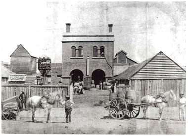
Photograph - NORFOLK BREWERY, 1961
black and white photo: rear of Norfok Brewery, mid centre brick building, 2 arched doorways on ground floor, 2 double arched windows top floor, 1 chimney at each end of roof. Lane fence at front. Dove cote, 2 buildings at right. Tall timber building at left centre., Tall timber at left centre. ' Batchelder photographer Pall Mall' van and horse left front. Horse and dray with 3 barrels right front. 3 men handling barrels. Slab fence, slab buildings at right. Written on side of horse cart: Sayer & Co.batchelderbuildings, commercial, produce store -
 Bendigo Historical Society Inc.
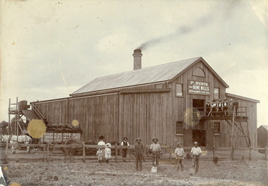
Photograph - BENDIGO BONE MILLS, c1880
Sepia photograph on grey mount of P Rohs Bone Mills, artificial manures, flock mills. Timber building, with large brick chimney stack. Dray loaded with bags of manure pulled by white horse. Female and male figures on platform in front of building. Two children and group of five males and one female on ground. Inscriptions: in image - 'P Rohs, Bendigo Bone Mills, Artificial manures, flock mills'. On cart in image - 'Bendigo Bone Mills', On front TR corner 'MP115'. On back - 'Peter Rohs Fertilizer Factory, Rohs Road, Bendigo c1880'. Handwritten on back in ball point pen.buildings, commercial, p rohs bone mills -
 Ballarat Tramway Museum
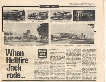
Newspaper, Herald & Weekly Times Ltd, When Hellfire Jack rode...", 15/04/1972 12:00:00 AM
1037 - Newspaper clipping from The Sun (Melbourne), April 15, 1972 in the Magazine section of the newspaper, called 'Then and Now' about the closure the following day of the Bendigo tramways. Gives an outline history of the tramway system, and two stories about the tramways, one about a driver named "Hellfire Jack" and an accident between a tram he was driving and a horse pulled dray loaded with tomatoes. Has six small photos on the top of the item, four of trams and two of Bendigo looking towards Charing Cross from the Post Office in 1880 and 1972. 1037.1 - added 23/10/2004 - duplicate cutting. Item written by John Fraser.trams, tramways, bendigo, closure, hellfire jack, charing cross -
 Bendigo Historical Society Inc.
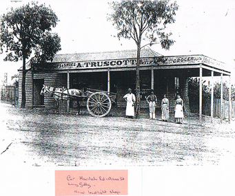
Photograph - LONG GULLY HISTORY GROUP COLLECTION: A TRUSCOTT & CO
A. Truscott took over this drapery and grocery store from Mr Pengally upon his retirement in November 1884Copy of a black and white photo of A. Truscott & Co., Family Grocer, Long Gully. Weather board building with a veranda. Two gum trees in front of the shop. A grey horse is harnessed to a dray and there are two men and two women behind it. A pink sticker is stuck on the bottom with - Cnr havilah Rd , Arms St. Long Gully. Now Leadlight Shop - written on it. Written on the back is: Verandah blown off by whirly wind Landed on top of shop roof. Now replaced 1986. Cnr Havilah Rd & Arms St. This photo also has references in Box 704, Truscott collection, 12322 - 12324.bendigo, history, long gully history group, the long gully history group - a truscott & co, leadlight shop -
 Orbost & District Historical Society
black and white photograph, late 19th century - early 20th century
This is a photograph of Alice Swallow's hotel at Cabbage Tree. The settlement of Cabbage Tree Creek is located on the Princes Highway, 27 km east of Orbost in East Gippsland. The first white settler arrived in the valley in 1887 cutting a dray track from Marlo to the south-west. Several families cleared the alluvial flats, growing maize, peas and beans and raising pigs, cattle and sheep. Later the farmers milked cows, sending cream to Orbost. In the late 1890s, small quantities of alluvial gold were found in the creek. A school commenced classes in 1913, but enrolment was small and at times the school operated part time with several other small schools in the area. The school building served as a hall for the district. From the 1920s the Cabbage Tree Hotel catered to drivers on the improved Princes Highway. (info. from Victorian Places)This is a pictorial record of Cabbage Tree, East Gippsland in the late 20th century. It shows a building that no longer exists.A black / white photograph of a small, single - storey wooden building in a bush setting. There are people standing in front of the building with a horse and wagon nearby. In the foreground is a wagon with four horses hitched to it and the driver seated behind the horses. -
 Orbost & District Historical Society
black / white photograph, 1897
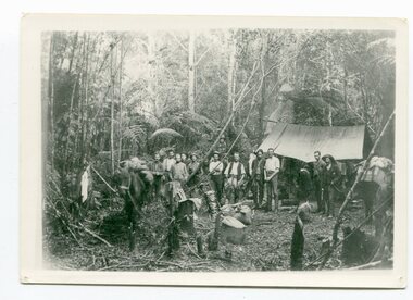
Link with item 1178. This is a surveyors' camp in the McCulloch Ranges, Murrangowar, April, 1897. Included in the photograph are: L. Thorn; Pearson; L. Coburn, Clem Bates; Sam Blacklock with a packhorse. They were surveying for a road or railway. Surveyors were among the first European settlers to arrive in Australia. A Surveyor-General was present on the First Fleet, as well as the first two ships which landed in South Australia. These men were issued with instructions to record observations in a journal that included the country’s general appearance, its soil, flora and fauna and the customs and language of local inhabitants. The conditions they worked in were harsh and they embarked on journeys with drays carrying cumbersome surveying and camping equipment, spending months camping out in the bush and mapping the land. It was not until well into the second half of the nineteenth century that the professional training of surveyors became mandatory in Australia.This is a pictorial record of a surveyors' camp in the late 19th century.A black / white photograph of a group of men standing in front of a tent / camp in a dense bush setting.surveyor's-camp-mccullochs-ranges-murrangowar land-settlement -
 Ballarat Heritage Services
Photograph - Photograph - Colour, Clare Gervasoni, Tarilta, 2017, 16/07/2017
Tarilta is a rural locality and former gold-mining town 12 km south of Castlemaine, 4 km north-west of Guildford and 3 km north-east of Vaughan. The last gold mining activity took place around the 1880s. It was originally Kangaroo Flat, being located where the Kangaroo Creek enters the Loddon River. It was surveyed and named in 1864. Gold was discovered at Tarilta in 1853. The Tarilta School was opened in 1860 in a Wesleyan chapel, and closed i n1925. In 1864 a township was surveyed and named Tarilta, the word being derived from an Aboriginal expression thought to mean kangaroo. In 1865 Bailliere’s Victorian gazetteer described Tarilta as being an alluvial and quartz gold-mining town with three quartz-crushing mills, three horse-puddling machines and two hotels. The elevated nature of the land around Tarilta made it accessible only by horse and dray, or on horseback. Colour photograph of Tarilta in Central Victoria. tarilta, central victoria, landcape -
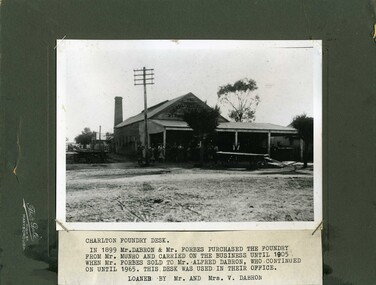 Charlton Golden Grains Museum Inc
Photograph, Gale, Thomas, Charlton Foundry c. 1910, c.1910
Charlton Foundry corner of Learmonth and High Sts Charlton. Established by C. Munro in 1885 and purchased by Dabron & Forbes in 1899. Taken over by Alfred Dabron in 1905 who managed it until he closed it down in 1965. Makers of the Premier HarvestersBlack & white mounted photograph. Copy of photo mounted on original mount. One of a set of three. Large group of men in front of the Foundry buidling. Photo looking along Learmonth St. Dray parked in front of men. Large chimney at the rear of the building. Group of men in Learmonth St. Typed note attached to photo says "Charlton Foundry Desk. In 1899 Mr. Dabron and Mr. Forbes purchased the foundry from Mr. Munro and carried on the business until 1905 until Mr. Forbes sold to Mr. Alfred Dabron , who continued on until 1965. This desk was used in their office. Loaned by Mr. and Mrs. V. Dabron."Thos. Gale High St Maryboroughcharlton, foundry, business, industry -
 Kiewa Valley Historical Society
Four photographs of the Blue Duck Hotel and two Photos of the Glen Wills area, c1920 Post cards, c1949/50 small photographs
The Blue Duck Hotel stands at the confluence of 3 trout rivers - Cobungra, Bundarra and Mitta Mitta, called Angler's Rest. The original 1900's building was of slab construction and operated as a butcher shop, servicing miners on the track from Omeo to Mt. Wills. In 1912 it was purchased by a miner, Billy O'Connell, and he obtained a hotel license. In the early 1920's he transported 2 houses from Omeo on Horse drays. One is the main building of the Blue Duck and the other was a residence where Billy and his wife raised their nine children. The small log structure behind the pub is State School No.4286 where the children attended school. A teacher was shared with Glen Wills. By the late 1920's the hotel was discovered and patronized by keen anglers. Sir Harold Clapp (head of the railways) was one and he had the bronze blue duck cast and presented to the owners in the 1930's. This stands at the entrance to the premises.These photographs are of a building, in a remote area, that has provided a service to miners, anglers and travellers for over 100 years and continues to do so today. It also played a vital role in the history of the Mt. Wills/Omeo gold mining days.3 Post cards, Black and White photographs. 3 small black and white photographsPost Card No. 1 - "Blue Duck Hotel- Omeo-Glen wills road Ray Love Series No.2"(written on lower front) Post Card No. 2- "Looking towards Bogong High Plains. Omeo-Glen Wills road"(front, bottom, L hand) Ray Love Series No. 18 (front, lower R hand corner) On both of above photos, centre back, is stamped POST CARD and underneath this is printed "A GENUINE PHOTOGRAPH'/ Post Card No. 3 - Bottom L hand corner "Mystic Sea Australian Alps". R hand corner "(Bulmer Copyright)". Each small photograph, handwritten on back "Blue duck Hotel". All have circular stamp with "Print by Wilson White Albury" blue duck hotel; anglers rest; omeo highway; fishing; mining -
 City of Moorabbin Historical Society (Operating the Box Cottage Museum)
Document, Photocopy Letter Thomas Charman to Michael Charman UK 1878, 1878
Thomas Charman came to Australia with his brother Stephen and went to Sydney. Thomas came to Melbourne c 1853 with a large dray and bullock team and with his son took supplies to the Victorian Gold digging sites. Quite profitably. Stephen Charman, aged 21years, arrived in Melbourne in 1842 as one of Henry Dendy's Emigrants. 1852 he purchased 160 acres for £328 bounded by Charman Rd and Balcome Rd. 'The Spring' was an important water source for the local Aboriginal people and then for the early settlers. Charman's first wife Harriet and their infant child died and in 1850 he married a widow with 5 children, Mary Gettens. Their first home was made of wattle and daub and they had 7 more children. Later a weatherboard cottage was built c 1855 Together they developed a market garden and specialized in marigolds which were sold for medicinal purposes to the Melbourne Chemists - Martin & Pleasance Thomas Charman arrived in Australia 1842 with his brother Stephen and moved to Sydney where he obtained a large dray and bullock team. He delivered supplies to the Goldfields and realized this was more secure than chancing to find gold by digging. Thomas returned to Melbourne when the Victorian Mines became more numerous than NSW and profitably delivered to the Victorian gold fields .Letter, handwritten from Thomas Charman to his brother Michael in UK 1878 x 3 pagesHandwritten -
 Surrey Hills Historical Society Collection
Photograph, 213 Union Road, Surrey Hills c1930, 1930
The photo shows part of the process of moving a yacht, named 'Sonia' from 213 Union Road, the home of the Fleming family. It was built in the shed garage of the house and moved from it by horse and dray. The home belonged to Harold Arthur Fleming (1891-1971) and his wife, Georgiana Phyllis (nee Griffiths: 1895-1936). Harold built the boat. They had 3 children - Eric Alexander (1918-1920), Sybil Patricia (1921-2012) and another girl. The shed /garage had been the old coach house of the adjoining property, 215 Union Road. the boat was launched at the Brighton Yacht Club. Harold was a draughtsman. The Flemings lived in a number of houses in Surrey Hills: 1. 1919 - 'Radnor' in Croydon Road; the name possibly derives from Radnorshire, Wales where Georgiana was born. 2. 1921 - 169 Union Road 3. 1931 - 213 Union Road. The donor (deceased) was the daughter of the builder and married Keith Andrew Fleming. A black & white photo with 3 draught horses in the foreground. Beyond the path and fence behind them is the roof of 213 Union Road. Between the fence and the house the view is blocked by the hull of a yacht.harold arthur fleming, miss georgiana phyllis griffiths, mrs georgiana phyllis fleming, 213 union road, horses, boating -
 Wodonga & District Historical Society Inc
Album - Ringer's River by Des Martin - Plate 1 - Sean O'Day, Horse Breaker at "Gooloora" discusses his future
On a summer's day in 1891 Sean O'Day, Horse Breaker on James MacLough's "Gooloora" Station, is driving the Scots pastoralist in to the railhead at Overton after his annual inspection of that property. Silent and mature for his age, Sean was born in a dray while it was crossing the river during a flood, and has remained at home in it. Because he is always moving by dawn he is known in the borderland as Daylight O'Day. When MacLough asks him what he will be doing on the morrow O'Day replies that he will be manager. Questioned, he suggests that MacLough realises the background to his joke in that the station hands will, that night, celebrate the passing of the Boss's inspection. As they will have hangovers tomorrow all the work will naturally fall to himself, a teetotaller. MacLough nods assent, but, instead of leaving on the train, books a room for the night and a livery gig for the morrow, and drives himself to Gooloora early next morning. D.J. Martin as O'Day, H.S. Diffey as MacLough.The album and images are significant because they document literature written by a prominent member of the Wodonga community. The presentation of this precis was supported by several significant district families and individuals.Ringer's River Album Coloured photo Plate 1des martin, many a mile, ringer's river, northeast victoria stories -
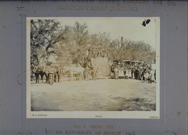 Bendigo Historical Society Inc.
Photograph - COHN BROS. BREWERY EMPLOYEE'S PICNIC, 7th March, 1903
Sepia photograph of Cohn Bros. Brewery Employees Picnic. Procession of horse drawn vehicles with employees? On dray, draped with Cohn Bros flag, followed by horse drawn buggies with groups of people on board. Group of males, females and children and a black dog. Male figure with drum. Inscriptions: printed on mount on front 'Cohn Bros Victoria, Brewery Co. Ltd, Employees Picnic, held at Cherry Tree on Saturday 7th March, 1903. On back - 'Royal Historical Society of Victoria, Bendigo Branch' circular stamp on reverse. Hand written in pencil on back 'from WL Newell, 30/07/74', 'William Pd in black lead pencil. History: Prev Acc. No. GP24WH Robinson, Photo, Bendigoperson, group, employees, see also 2001.201.01, 2001.202.01, 2001.204.01, 2001207.01, 2001.208.01 -
 Phillip Island and District Historical Society Inc.
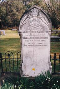
Photograph Album, Kodak, Phillip Island Cemetery, c 1990
The Album was compiled by Nancy McHaffie late 1990's, with the assistance of Edith Jeffery's, with her book "Garden of Memories" and extensive knowledge of Phillip Island. The Cemetery lies back from the road and is surrounded by Manna Gums, rare Peppermint Gums, Blackwoods and other native trees. In all 25 acres of land were set aside as Crown Land in the land settlement of 1868. There are 6.2 acres of wetlands near the cemetery entrance.466-25: William and Alice Richardson: Alice Barnard married William Richardson at Hawthorn, April 1887. Alice's father Fredrick was a Model Maker employed at the Melbourne Museum. Alice died in childbirth having her third child, Joseph in 1892. Baby Joseph died in April 1893, eight months later at Rhyll. 466-26: The Forrest Family: The Forrest family were amongst our early settlers. The Forrest Caves are named after them. Matthew Forrest arrived by dray from Tarradale on 9th November 1869. He died in 1916 at the age of 75. His Grandson, Peter Forrest Sr. has recorded that Matthew was the first to plant Marum Grass on the Island to prevent erosion.phillip island cemetery, nancy mchaffie, edith jeffery -
Glenelg Shire Council Cultural Collection
Photograph - Sheet of 12 contact prints - Various historic Portland buildings and Landmarks, c. 1970
Sheet of 12 contact prints of rephotographed photographs. Identifying numbers 5720 a, b, c, d, e, f, g, h, i, j, k, l (a) Observatory Hill (b) Builders Arms Hotel (c) First jetty and immigration depot (d) Pile driver-1st pile Ocean Pier (e) Residence of William Corney (f) Row of single wooden houses on beach, Observatory Hill in background (g) Double storey stone building (h) Mrs Edward Henty (i) View of spit from Henty Beach (j) Julia Street (k) Same as (c) - First jetty and immigration depot (l) Dray loaded with bales outside Grant & Co merchants -
Glenelg Shire Council Cultural Collection
Photograph - Sheet of 12 contact prints - Various historic Portland buildings and Landmarks, c. 1970
Sheet of 12 contact prints of rephotographed photographs. Identification numbers 5719 a, b, c, d, e, f, g, h, i, j, k, l (a) Portland Tennis Club (b) Portland Show (c) Court House (d) Row of single storey wooden buildings on beach, Lighthouse of Observatory Hill back left (e) Fishing party Bridgewater (f) Dray loaded with bales outside Grant & Co Merchants (g) Image of Capt. James Fawthrop (h) Residence Abraham Barrett, baker (i) Group of 6 in tennis clothes late 1900's - early 1900's style (j) Portland Tennis Club (k) Tasmanian Inn (l) Windsor CottageFront: (a) Working-Bee, Portland Tennis Club approx 1900 (b) Portland Show (c) Court House (e) Angling Party, Bridgewater approx 1900 (g) Capt. Fawthrop -
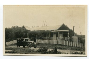 Orbost & District Historical Society
black and white photograph, 1920s -1930s
The Cabbage Tree Creek township was originally established to support the booming timber industry of the mid 20th century. Five timber mills worked full time supporting the families that were drawn to the area's wealth of natural resources. The settlement of Cabbage Tree Creek is located on the Princes Highway, 27 km east of Orbost in East Gippsland. The first white settler arrived in the valley in 1887 cutting a dray track from Marlo to the south-west. Several families cleared the alluvial flats, growing maize, peas and beans and raising pigs, cattle and sheep. Later the farmers milked cows, sending cream to Orbost. In the late 1890s, small quantities of alluvial gold were found in the creek. A school commenced classes in 1913, but enrolment was small and at times the school operated part time with several other small schools in the area. The school building served as a hall for the district. From the 1920s the Cabbage Tree Hotel catered to drivers on the improved Princes Highway. (info. from Victorian Places)This is a pictorial record of Cabbage Tree, East Gippsland in the late 20th century. It shows a building that no longer exists.A small black / white photograph of a single storey timber building. On a sign below the roof is "Cabbage Tree Hotel". The hotel is surrounded by a wooden picket fence. A man and woman are standing on either side of a motor car parked on the roadway in front of the building.on back - on label - Cabbage Tree Hotelcabbage-tree-hotel -
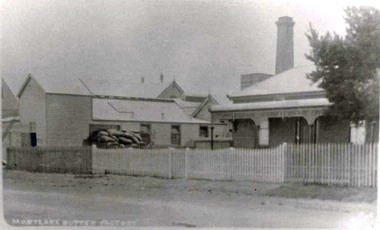 Mortlake and District Historical Society
Mortlake Butter Factory Co. Ltd, Photograph
This local factory was typical of small butter factories in the 1890's in Western Victoria. It was established in 1894 when farmers brought their milk to the factory on horse drawn drays and carts and waited for their cream to be separated. The skimmed milk was mostly used by farmers to feed calves and pigs and the separated cream was manufactured into butter, some of which was exported to England. By 1910 this butter factory had an electricity generating plant called Mortlake Electricity which supplied both the factory and the township with power and this took precedence over the butter production which continued until 1926 when it was sold to the Electricity Commission. By 1930 the Butter Factory had a yearly turnover of 24,000 pounds sterling and in1935 it was producing 6 tons of butter weekly. But in 1936 the factory was sold to Glenormiston Cheese & Butter Factory who ceased operations. The manager's residence still remains in 2011 as does the remnants of the small timber butter factory (charcoal lined) and the double brick cheese room but the bluestone chimney has long gone. This complex is listed by Heritage Victoria Black and White Photograph Nonecheese factory, mortlake, butter factory -
 Orbost & District Historical Society
Photograph, 1930s
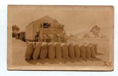
Maize has been grown on the Orbost flats for at least 70 years. When early settlers began to arrive on the Snowy River somewhere in the 1880s, the land was mostly swamps and heavily timbered jungle on the river frontages. The swamps were drained, bit by bit, with short handled shovels working in mud and water. The frontages were cleared by axe and shovel and fire. Several kinds of crops were experimented with such as hops, hemp and maize which grew particularly well and became the main crop of district. The problem then was to thresh and deliver the product to the market. A small single cob machine was brought here and one man turned the handle, while the boy or Mum fed the cobs singly into the machine. A good day’s work would thresh about 50 bushels or about 12 bags (4 bushels). The task then was to cart the maize to market. For a few years this was done by horses and dray carrying about 60 bushels to Mossiface, where it was loaded onto river boats to Lakes Entrance, and then by ocean boats to Melbourne. (information from NEWSLETTER OCTOBER, 2006)The growing of maize in the Orbost district contributed significantly to the economy of the township for many years, The many maize cribs once seen on the surrounding farms have now disappeared and this photograph is a pictorial record of that significance.A small sepia photograph with six men in front of a wooden barn. They are bagging maize. In the foreground are two rows of filled bags. On the right is a lifting machine to take the bags to the top storey. On the far right is a water tank on a stand"on back - "Thrashing Maize"maize-orbost agriculture-maize industry -
 Orbost & District Historical Society
black and white photograph
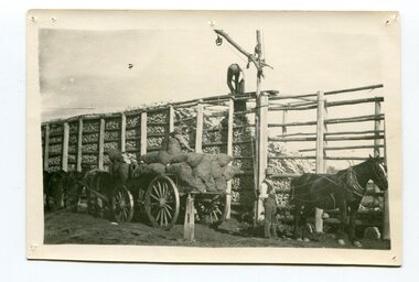
Maize,has been grown on the Orbost flats for at least 70 years. When early settlers began to arrive on the Snowy River somewhere in the 1880s, the land was mostly swamps and heavily timbered jungle on the river frontages. The swamps were drained, bit by bit, by men with short handled shovels and working in mud and water. The frontages were cleared by axe and shovel and fire. Several kinds of crops were experimented with such as hops, hemp and maize, the latter grew particularly well and became the main crop of district. The problem then was to thresh and deliver the product to the market. A small single cob machine was brought here and one man turned the handle, while the boy or Mum fed the cobs singly into the machine. A good day’s work would thresh about 50 bushels or about 12 bags (4 bushels). The task then was to cart the maize to market. For a few years this was done by horses and dray carrying about 60 bushels to Mossiface, where it was loaded onto river boats to Lakes Entrance, and then by ocean boats to Melbourne. Later it was taken to Bairnsdale by foot and loaded onto the trains to Melbourne. (more information in Newsletter October 2006)The growing of maize in the Orbost district contributed significantly to the economy of the township for many years, The many maize cribs once seen on the surrounding farms have now disappeared and this photograph is a pictorial record of that significance.A black / white photograph of a man unloading maize from a horse-drawn wagon into a maize crib. Another man is standing by the horse.maize-crib-orbost agriculture maize-corn-orbost -
 Orbost & District Historical Society
black and white photograph, late 19th century - early 20th century
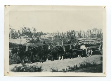
Maize, or corn as it is called in America and New South Wales, has been grown on the Orbost flats for at least 70 years. When early settlers began to arrive on the Snowy River somewhere in the 1880s, the land was mostly swamps and heavily timbered jungle on the river frontages. The swamps were drained, bit by bit, by stout hearted men with short handled shovels and working in mud and water. The frontages were cleared by axe and shovel and fire. Several kinds of crops were experimented with such as hops, hemp and maize, the latter grew particularly well and became the main crop of district. The problem then was to thresh and deliver the product to the market. A small single cob machine was brought here and one man turned the handle, while the boy or Mum fed the cobs singly into the machine. A good day’s work would thresh about 50 bushels or about 12 bags (4 bushels). The task then was to cart the maize to market. For a few years this was done by horses and dray carrying about 60 bushels to Mossiface, where it was loaded onto river boats to Lakes Entrance, and then by ocean boats to Melbourne. ( from NEWSLETTER OCTOBER, 2006) This is a pictorial record of farming practices in Orbost in the early 20th century.A black / white photograph of a horse team hauling a wagon loaded with bags of maize.A man is sitting on the edge of the wagon.farming-orbost agriculture maize corn transport -
 Bendigo Historical Society Inc.
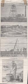
Newspaper - VICTORIA QUARTZ - PHOTOGRAPHS OF MINING
Four photographs from a Supplement dated Thursday, November 14, 1901. Top photo is a picture of the Victoria Quartz poppet legs, buildings and a large chimney. The second photo is a puddling machine. In the photo is a circular area with water in it and an island in the centre with a log across it. A horse is harnessed to one end of the log. There is a man behind the horse and a dray in the background. The third photo is a whip. It is a pole held at an angle by two smaller poles. At the top is a wheel. There is a rope over the wheel with a bucket on the end. There are two men to the right of the whip. The bottom picture is a man dollying. He has a half barrel and he is working the water with a short pole with a handle on each side. The barrel has a drainage pipe in the bottom. There is also a dish, two buckets and a shovel around the barrel. There are two photocopies of the page. One didn't get all the fourth picture copied.photo, victoria quartz, victoria quartz, photographs of mining, puddling machine, whip, dollying