Showing 572 items
matching land surveyed
-
 Federation University Historical Collection
Booklet - Report, Report and Recommendations to the Council of the School of Mines and Industries, Ballarat on the Master Plan for the Mt Helen Development, 11/1968
A master plan for the campus was developed by L.H. Vernon and Associates. Geoff J. Harrison prepared a report and made recommendations on the master plan, including suggestions for improvement. Grey card covered, stapled, foolscap report on the Mount Helen Development. It included 14 typed pages and 6 plans. The report covers: Campus planning, Mt Helen Master Plan, retention of trees, sports fields, student accommodation, student amenities, library, car parking, site, landscape, land use study, Mt Helen Site, L.H. Vernon.mount helen master plan, masterplan, master plan, vernon, g.j. harrison, harrison, education, topography, survey, jd fisher, aa jeffreys, hugh mitchell, john vernon, geoff harrison, mount helen master plan, l.h. vernon, campus plan, mount helen campus -
 Federation University Historical Collection
Book, G.J. Harrison, Review of Development Plan for the Mount Helen Campus Ballarat, 1975, 1975
... valley aquinas college site survey land use zones landscaping ...In 1967 the site for the Mt Helen Campus was selected and purchased to permit the tertiary division of the Ballarat School of Mines - the Ballarat Institute of Advanced Education (BIAE) to move from the crowded Lydiard Street site, to occupy new accommodation designed for the purpose. The brief given to the campus master planners called for the creation of a modern, attractive, efficient and stimulating concept. It called for careful landscaping and enhancement of the environment, but above all it demanded flexibility for an unpredictable future. During 1974 major new directions were made at Government level quite beyond the scale of change that had been foreseen in 1967. This change was to be that of merging BIAE and the State College of Victoria at Ballarat (formerly Ballarat Teachers' College) into one large new college of broadened scope. By the end of 1974 joint committees representing the still separate, autonomous Councils of the two institutions had agreed on the means of achieving the merger to the extent that a new brief as prepared and given to G.J. Harrison, one of the original master planners who had been chosen to revise the plan to meet the new needs. Yellow soft covered book of 63 pages reviewing the Development Plan for Mount Helen Campusuniversity of ballarat, ballarat institute of advanced education, mount helen, master plan, ballarat college of advanced education, mb john, ian gordon, pdf, development plan, mount helen campus, g.j. harrison, state college of victoria ballarat, m.b. john, canadian valley, aquinas college, site survey, land use zones, landscaping, campus plan, mt helen campus -
 Federation University Historical Collection
Instrument - Survey Chain, Chesterman, Gunter's Survey Chain
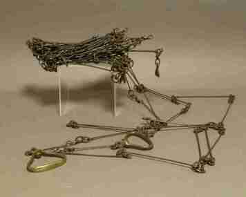
Before metric measurement was introduced land was measured in chains and links. The chain was a precision part of a surveyor's equipment. It required frequent calibration, yet needed to be sturdy enough to be dragged through rough terrain for years. A standard survey chain is 66 feet (or 20.117m) long and made up of 100 links. Each link is 7.92 inches (approximately 201mm) long, measured from the inside of the loop. The handles are for tensioning the chain in use, they are not part of the length of the chain. In pre-metric units, there were 80 chains to 1 mile (equals 1.609km) This surveyor’s chain has an 8-inch link pitch, with markers at 10 link intervals. This metal surveyor’s chain (or Gunter's Chain) has an 8-inch link pitch, with markers at 10 link intervals, and handles at either end. A Surveyor’s Chain was 66 feet long, and made up of 100 links connected by two rings. A link in measurement includes the two rings at each end. gunter's chain, survey chain, surveyor s chain, perch, rood, surveying -
 Federation University Historical Collection
Book, A Rudimentary Treatise on Land Engineering Surveying, 1902
... covered book A Rudimentary Treatise on Land Engineering Surveying ...Brown hard covered booksurveying, baker, dixon, f.e. dixon, t. baker, engineering -
 Federation University Historical Collection
Plan, Burrumbeep, 1884, 16/10/1884
Auctions of Crown land were introduced in the Colony of Victoria from 1851 to encourage settlers to occupy and work the land. Many squatters purchased land at auction at the upset (minimum) price of £1 per acre. In some areas where demand was high, such as the goldfields, the price realised at auction was much more. Land was put up for sale in the study area on the Burrumbeep run in May 1855, on the Lexington run in 1857, and on the Gorrinn run in 1858. (http://www.ararat.vic.gov.au/library/document/thermatics.pdf, accessed 27 January 2015) For 70 years or more, Yalla-y-Poora, Burrumbeep, Edgarley, Mount William and Narrapumelap ranked in the leading wool producers in Victoria. 1 Stud owners at Yalla-y-Poora, Eurambeen, Burrumbeep and Challicum crossed merino sheep with sheep descended from John Macarthur's Camden Park in New South Wales. (http://www.ararat.vic.gov.au/library/document/thermatics.pdf, accessed 27 January 2015) In what was to become the Ararat Mining Division, gold was discovered in May 1854 on the Burrumbeep run at a place that became known as Pinky Point on the Mount William goldfield. By 21 June 1854, between 600 and 1,000 people had arrived. (http://www.ararat.vic.gov.au/library/document/thermatics.pdf, accessed 27 January 2015)\ Town allotment plan for Burrumbeep. Merrymbuela, Borung, Lexington and Langi Logan are neighbouring areas. The plan includes the Burrumbeep Pre-Emptive Right (Roger and Wright); licensed land holders including Stephen Young, John Carroll, William Walsh, Thomas Purcell, Martha M. Bond, Colin Johnson, John Charles Webb, Henry Withycombe, William Henry Barbridge, John Wall, Thomas Flatelly, William Jenkinson, Elisia Radford, V. Radford, Denis Byrne, George Cook. Land holders included Andrew Maloney, Richard Wingfield Harrocks, W. Sporton, Terence Lynch, F. S. Falkiner, A. Millman, H. Morris, George Upham, J. McCLure, S. Fletcher, W. Parker, Thomas Myers, William wright, W.C. Winter, C. Wordman, Oliver A. Winter This plan is associated with former Ballarat School of Mines student Richard Squire (1875-6) Gift of the Squire FamilyVerso written in pencil - Plan of Burrembeep Ararat Burrembeep Araratburrumbeep, corrinn, langi logan, merrymbuela, lexington, ararat, roger & wright, cook, rogers, upham, george upham, ross, parsans, morris, johnson, withycoombe, colin johnson, falkiner, dsporton, john carroll, donald gordon, denis bryne, maurice dooley, martha bond, william harricks, \william wingfield harricks, william l.c. harricks, michael houlihan, thomas purcell, martin ryan, michael cody, fletcher, mccaw, w. parker, j.m. clow, elisia radford, thomas radford, thomas myers, barbridge, e. wilde, j. wall, flatelly, g. wardman, w.c. winter, david ball, jenkinson, ballarat school of mines, richard squire, squire -
 Federation University Historical Collection
Plan, Smythesdale, County of Grenville, 01/12/1892
This plan is associated with former Ballarat School of Mines Student Richard Squire (1875-1876). Gift of the Squire FamilyA plan showing the Borough of Smythesdale, Smythesdale, Browns and Scarsdale, allotments, water reserve, Timber reserve, Nintingbool Pre-emptive Right, Reserve for public gardens, Reserve for Cricket Ground, Reserve for Reservoirsmythesdale, scarsdale, browns, yarrowee, carngham, samuel barlett, sheridan, wrigley, p. land, r. simpson, d. davis, nintingbool, mclachlan, a. mclachlan, c. taylor, w. c. smith, d. davies, w. williams, m. jones, t. mcgurk, r. selkirk, a. mooney -
 Federation University Historical Collection
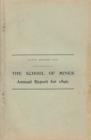
Booklet - Annual Report and Calendar, Ballarat School of Mines Annual Report and Calendar, 1896
... - mine and land surveying mining mechanics hydraulics civil ...The Ballarat School of Mines was the first Technical School on Australia..1) Ballarat School of Mines Annual Report .2) Ballarat School of Mines calendar The Ballarat School of Mines Calendar and Annual Report 1896. Associateship of The School, Calendar for 1896, Certificates Granted by Education Department 1894, Certificates Issued by The School 1895, Certificates Issued Prior to 1895, Certificates Issued by Education Department 1895, Examiners, Examination Fees, Fees, Honorary Correspondents, Life Governors, Meteorological Observations, Number of Students attended The School, Office Bearers, Professors and Lecturers, Report of the Superintendent of Laboratories, Report of the Professor of Mineralogy, Geology and Botany, Report of the Professor of Engineering, Report of the Lecturer on Mathematics, Report of the Instructor in Engineering Drawing, Report of the Lecturer on Electricity, Report of the Teacher of Drawing, Report of the Lecturer in Veterinary Science, Statement of Receipts and Expenditure for year 1895, Statistics - Student attending Lectures, Subscriptions and Donations, Subjects Included in Regulations Technical Schools, Time Tableballarat school of mines, examiners, examination fees, fees, honorary correspondents, life governors, meteorological observations, number of students attended the school, office bearers, professors and lecturers, report of the superintendent of laboratories, report of the professor of mineralogy, geology and botany, report of the professor of engineering, report of the lecturer on mathematics, report of the instructor in engineering drawing, report of the lecturer on electricity, report of the teacher of drawing, report of the lecturer in veterinary science, statement of receipts and expenditure for year 1895, statistics - student attending lectures, subscriptions and donations, subjects included in regulations technical schools, time table, annual report, calendar, andrew anderson j.p. - president, hon. r. t. vale - vice president, r. denham pinnock - vice president, the hon. sir w. j. clarke - trustee, the hon. john warrington rogers - trustee, the right reverend samuel thornton - trustee, andrew anderson - trustee, james millhinch - trustee, james oddie - trustee, the hon. henry cuthbert - honorary solicitor, r. g. middleton - honorary treasurer, charles kent - auditor, fred. j. martell - director and registrar, professor alf. mica smith - chemistry, metallurgy, natural philosophy, professor purdie - geology, mineralogy, principles of mining, professor g. j. dawbarn - mine and land surveying, mining mechanics, hydraulics, civil engineering, applied mechanics, j. rowe - practical mining, w. huey steele - electrical technology, electricity and magnetism, d. walker - chemistry and natural philosophy, w. e. bennett - mathematics, henry j. hall - freehand and perspective drawing, a. e. c. kerr - mechanical drawing (machine construction and design), j. f. usher - paleontology, zoology, materia medica, professor purdie - botany, george clegg - building construction, l. hart - photography, h. g. a. brown - carpentry, r. e. weir - veterinary science, daniel walker, henry cuthbert, james millhinch, jams oddie, j.f. usher -
 Federation University Historical Collection
Book, Ballarat School of Mines Calendar, 1903
... labratory museum land and mine surveying applied mechanics machine ...Contents include: Associateship and final certificates; Calendar for 1903; Discipline; Fees; Full Certificates issued; general regulations: Honorary Correspondents: Office Bearers; Professor and Lecturers; Results of exams; Statistics; Subscriptions and Donations; Subjects included in Regulation Technical Schools; Subjects on Instruction; Subjects included in Associateship course, Time table. Images include: Andrew Anderson, Lecture Rooms (Administration Building), Senior members of staff, School Buildings and Grounds, Linkenbach Table - Battery Laboratory, Engineering laboratory interior, junior Chemistry Laboratory; Assay Laboratory, Battery Laboratory interior, Maddern FurnaceCharcoal soft covered book at 100 pages. ballarat school of mines, andersnon\bickett, vale, warrington rogers, oddie, dunn, figgis, david ham, herman, lindsay, lonie, maddern, middleton, morrison, nevett, pearce, scott, woolcott, wanliss, r.e. williams, henry cuthbert, thomas hart, charles kent, frederick martell, newman, william bailey, hamilton, bechervaise, george russell, thomas bath, r.m. serjeant, peter matthews, theo williams, alfred mica smithh, daniel walker, hubert murphy, charles deane, arthur garrard, valentine anderson, douglas runtin, john balyney, l. cameron, dawbarn, a.e.c. kerr, john adams, edgar mcconnon, hall, john m. sutherland, usher, charles campbell, metallurgy, geology, certificate as mine manager, certificat as assayer, labratory, museum, land and mine surveying, applied mechanics, machine drawing and dedign, mechanics applied to mining, engineering laboratory, electrical department, state school lectures, excursions, mathematics, physics, geometry, photography, chemistry, organic chemistry, assaying, mining gelogy, mineralogy, petrology, algebra, trigonometry, mensuration, land surveying, mine surveying, steam and gas engines, dynamics and heat, sound and light, magnetism and electricity, electrical tecnology, botany, veterinary science, engineering drawing, electroplating -
 Federation University Historical Collection
Document - Reports, Martin Westbrooke, Nanya Station
Nanya Station, owned and managed by the University of Ballarat (now Federation University Australia), was purchased with assistance from the Department of Environment and Heritage Government Caring for our Country program. Nanya Station is located in the Scotia country, west of the Darling Ana-Branch in far western New South Wales and consists of the Nanya Western Lands Pastoral Lease 3281 – Perpetual Leasehold Lot 1244 in Deposited Plan 762778, Parish of Winnebaga, County of Tara and part of Lot 1242 County of Windeyer. Nanya is within the tribal area of the Danggali Aboriginal people, a sub-group of the Barkindji. Many Aboriginal sites have been recorded adjacent to major rivers in the region providing evidence that these areas supported a large population. The Scotia region has one of the shortest stock grazing histories of western NSW. Along with five other Scotia properties, Nanya was created as a pastoral lease in 1927. The first European settlement on the land followed exploration of the area by Sturt and Eyre. In 1854, the Lake Victoria lease which encompassed this area comprised 465,000ha.included Scotia blocks 1, 2, 3 and 4, Amoskeag and Winnebaga which formed the area known as the Scotia. It was described as a region of thick mallee scrub, interspersed with bluebush flats and Belah woodland. In the 1920s artesian water was found and the dry Scotia country was surveyed and divided into six Homestead leases allocated by ballot (Withers 1989). All properties were approximately 30,000ha, with a recommended stocking level of 3,000 sheep. Winnebaga (renamed Nanya) was taken up by Gordon Cumming. He initially dug a dam near the southeast corner of the property. A larger ground tank and rudimentary dwelling at the site of the present complex was later established. An adjacent area was cleared and cropped to provide feed for the horses used in digging the earth tanks. The ruins of the original building are located between the shearing shed and Homestead Tank. A cottage was built in the 1930s and a more substantial Red Gum framed homestead in the early 1950s. The lease was held by Mr Gordon Cumming until 1984 when it was purchased by Mr Norm Scadding as an extension to the adjacent lease, Belvedere. It was sold in 1995 to Mr Rob Taylor of Waikerie then in 1999 to BeMax Pty. Ltd., a sand mining company. These last three owners all permitted use of the property by the University for teaching and research. The Centre for Environmental Management at the University of Ballarat had been involved in studies of flora and fauna in western New South Wales since 1988. Studies became concentrated on the Scotia region with its variety of intact ecosystems due to a short pastoral history. Of particular significance is a system of natural salt lakes of which the most extensive is the Scotia Discharge Complex located on Nanya Station. An extensive vegetation survey of the Scotia region Westbrooke et al. 1998) highlighted the significance of the area both in terms of the range of communities in relatively intact condition and the occurrence of species and communities of restricted distribution. Nearly 400 species were recorded of which nine had either not previously been recorded or have restricted distribution in western NSW. Twenty-two plant communities occur on Nanya Station of which two, Halosarcia lylei low open shrubland and Hemichroa diandra/Halosarcia/Frankenia low open shrubland, are dominated by species not previously recorded from NSW. H. lylei and Acacia loderi shrublands are listed as endangered under the NSW Threatened Species Conservation Act. As noted, the area has a relatively short grazing history and, due to the presence of large areas of mallee with a Triodia understorey and restricted water supplies, stocking rates have been low. The diversity of ecosystems in relatively intact condition and extensive areas of old growth mallee made Nanya a highly significant refuge for biological diversity. This factors led to the purchase of Nanya Station by the University of Ballarat in 2004 with the assistance of the Department of Environment and Heritage for the purposes of conservation, research and education. In 2010 the southern paddocks of Nagaella Station (10,000ha.) which lie along the northern boundary, were purchased with the assistance of Lower Murray Darling Catchment Management Authority and added to the Nanya lease to provide complete protection for the communities of the Nanya Discharge Complex and further high quality Malleefowl habitat. Four digital reports documents relating to Federation University's Nanya Station, Western New South Walesnanya station, scotia country, pastoral lease, winnebaga county, darling ana-branch, martin westbrooke, environmental education, nagaella station, lower murray darling catchment management authority, conservation research education, ian gribble, pat prevett, ian henderson, danggali -
Federation University Historical Collection
Book, Historic Sites Survey: North Central Study Area, 1979, 1979
The North Central Study Area included the Shires of Avoca, Bet Bet, east Loddon, Goulburn, Untly, Kara Kara, Korong, Maldon, Marong, Metcalfe, McIvor, Newstead, Strathfieldsaye, Stawell, Talbot, Clunes, Tullaroop and Waranga. 153 page book with white plastic binding. It is an historic sites survey for the North Central Study Area commissioned by the Land Conservation Council, the Ministry for COnservation and the Australian Heritage Commission. castlemaine, mount alexander goldfield, maldon, percydale, warrenmang, moliagul, tarnagulla, stuart mill, the whipstick, whroo, rushworth, graytown ironbark forest, st arnoaud, new bendigo, landsborough, inglewood, kurting, wedderburn, wehla, kooroora, langham flat, mcintyre, rheola, diamond hill, fosterville, coliban water works, green gully, newstead, muckleford forest, costerfield, graytown, bailieston, waranga irrigaiton system, eucalyptus distillery, mia mia bridge, korokubeal township researce, concegella slate quarry, chewton, fryerstown, kingower, timor, talbot, majorca, carisbroook, clunes, st arnaud, taradale, icomos, dunolly, limestone, castlemaine slate quarry, harcourt granite, taradale railway viaduct, loddon united waterworks trust, gouldburn weir, carisbrook lock-up, history of tree planting in streets, history of public reserves, r.u. nicholls nurseryman, thomas lang, francis moss, ballarat botanical gardens, ballarat school of mines botanical gardens, lake wendouree, victoria park, ballarat, muont holled smith, ballaarat old cemetery planting, eastern oval, ballarat east botanical gardens, ballarat east town hall gardens, eureka stockade reserve, ballarat observatory plantings, yarrowee creek plantings, yarrowee bluestone channels, ballarat woollen mill, band and albion mullock heap, black hill plantings, yarrowee creek channels, canadian creek channel, specimen vale channel, poverty point reserve, union jack reserve buninyong, imperial mine, buninyong, victoria street plantings, bridge mall, sturt street gardens, ballarat avenue of honour plantings, white flat oval plantings, camp street, elms, burnt creek -
 Flagstaff Hill Maritime Museum and Village
Document - Navigation Chart, Admiralty Office, Lady Bay and Warrnambool Harbour, 1893
This navigation cart of Lady Bay and Warrnambool Harbour was originally surveyed in 1870 but this version includes the update for magnetic variation in 1893. Since the printing of the chart several annotations have been added. These include an additional stamp dated 15-8-1910, a handwritten comment across the top of the page dated August 1910, and another handwritten comment regarding the ‘Proposed Extension of Dock’ dated 19-2-1925, plus connected drawings, notes and figures. The 1925 proposal on this chart may have been a reaction to the Royal Commission of 1923, when the damaged stonework on the seaward side of the Warrnambool Breakwater, caused by the action of the sea, was the subject of enquiry. A conference between the Public Works, Water Commission and the Harbour Trust concluded that it would less costly to make repairs to prevent further damage rather than replaced the damage portion of the wall. A contract was raised in late 1924 to deposit rubble on the damaged side of the breakwater to minimise the Southern Ocean’s destructive action and work had started by August 1925. The Breakwater construction had begun in 1874 and was completed in 1890. The Victorian Government had commissioned Sir John Coode, a British harbour engineer, to present a plan to complete the Warrnambool Breakwater but his original plan was too expensive. He prepared a revised plan for a shorter structure. The construction proved to be too short to protect adequately from the weather and didn't allow enough depth for larger vessels to come into port. The decreasing trade was further affected by siltation in the bay due to the breakwater, and the completion of the railway line. The situation of the harbour became a real problem by 1910 and required continuous dredging. In 1914 the Breakwater was extended but proved to be a failure because the work began to subside and by 1920 about two thirds of the harbour was silted up. Alterations made in the 1920's increased the silting problem and by the 1940's the harbour was no longer used. More alterations were made in the 1950's and 1960's. This chart is significant for its strong connection to the maritime history of Warrnambool Harbour and Lady Bay and the Warrnambool Breakwater. The Warrnambool Breakwater is registered as a place of significance on the Victorian Heritage Database (VHR H2024). The Warrnambool Breakwater is one of the most important late 19th century maritime engineering projects in Victoria and significant in the development of Victorian coastal shipping. It is also significant for its connection with British harbour engineer, Sir John Coode. The chart is a historical record of structures existing in 1893; the Warrnambool Jetties, Warrnambool Breakwater in Lady Bay, the leading lights (lighthouses), streets, roads, bridges and many buildings. It also shows the lay of the land and seabed. Navigation Chart: Lady Bay and Warrnambool Harbour, Australia - South Coast - Victoria. Surveyed by Nav. Lieut. H.J. Stanley, R.N., 1870. Updated for Magnetic Variation, 1893. The rectangular chart is printed on heavy cream paper. Stamps are shaped rectangular, oval and round. Around the Breakwater and Jetty area are handwritten notes, dotted and joined lines, numbers and signatures, and shading of red and green. The chart shows the surrounds of Warrnambool Harbour, Lady Bay, the Breakwater and Jetty, roads, bridges and the streets in Warrnambool. It has sounding details, and angles of line from the leading lights.Stamp, rectangular, including "AUG 1910" Stamp, double oval " - - - -CHART" Stamp, hand drawn, red circle, with "B" inside Hand written note "22-8-1910 - - - - - of surveying C. Ca - - - request of 15-8-10 [initials] " Notes and lines in red pen, including a grid of sounding numbers: "1300" "1050" "1200" "Possible Extension of Dock" "19-2-25" "Dock Dredged to 20 Ft" Notes and lines in blue pen "Extension of Dock to accommodate vessels drawing 20 Feet" and "Light not visible south of this line" Red dots (4) with yellow highlight at both leading lights, breakwater and jettyflagstaff hill, warrnambool, flagstaff hill maritime museum & village, maritime museum, maritime village, shipwreck coast, map, chart, navigation chart, plan, lady bay, warrnambool harbour, port of warrnambool, breakwater, jetty, pier, dock extension, proposed extension, vhr h2024, 1870, 1893, 1910, 1925, warrnambool town late 1800s, warrnambool streets late 1800s royal commission, 1923, public works, water commission, harbour trust, victorian harbours, sir jon coode -
 Flagstaff Hill Maritime Museum and Village
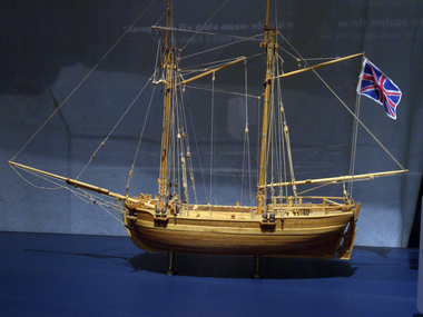
Craft - Ship Model, H.M.S. Lady Nelson, 1988
This model of the ship H.M.S. Lady Nelson was researched and built as the vessel Lady Nelson by David Lumsden, a professional ship model builder. His Majesty's Armed Survey Vessel Lady Nelson was commissioned in 1799 to survey the coast of Australia. This vessel was purpose-built before the British Admiralty requested plans for a Schooner for Port Jackson. At the time large parts of the Australian coast were unmapped and Britain had claimed only part of the continent. The British Government were concerned that, in the event of settlers of another European power becoming established in Australia, any future conflict in Europe would lead to a widening of the conflict into the southern hemisphere to the detriment of the trade that Britain sought to develop. Against this background, Lady Nelson was chosen to survey and establish sovereignty over strategic parts of the continent. Lady Nelson left Portsmouth on 18 March 1800 and arrived at Sydney on 16th December 1800 after having been the first vessel to reach the east coast of Australia via the Bass Strait. Before that date, all vessels had sailed around the southern tip of Tasmania to reach their destination. Lady Nelson's survey work commenced shortly after she arrived in Sydney, initially in the Bass Strait area. She was involved in the discovery of Port Phillip, on the coast of Victoria, in establishing settlements on the River Derwent and at Port Dalrymple in Tasmania. She also successfully chartered much of the Victorian coastline and was heavily involved with the exploration of the Queensland coast with Matthew Flinders; investigated the Hunter River; made numerous visits to New Zealand and Norfolk Island and was involved in the founding of numerous settlements. In comparison to most colonial vessels, the Lady Nelson was technically unique she was fitted with sliding keels, or centreboards, and water-tight trunks reaching to the deck. Captain Schank invented these sliding keels that, when raised, reduced her draught to less than six feet. Her life as an exploration vessel ended while accompanying HMS 'Tamar' to Melville Island in 1825, the 'Lady Nelson' was captured and later abandoned by pirates off the island of Babar (Indonesia). This brought the vessel's 25 years of coastal exploration and navigation to a close.The Lady Nelson made was the first British ship to survey of the southern or south-western coast of Australia and traverse the Bass Strait. The vessel holds a special place in Australia's history of exploration as the first to explore and establish settlements in the then-new British colony of Van Diemans Land. The model gives an insight into what life must have been like onboard sailing vessels of the time and Australia's early history of establishment and exploration. This model acts as an important legacy of the full-scale ship which no longer survives. Ship model of the 60 ton British brig HMS Lady Nelson. Timber model of a two-masted brig with rigging but no sails, displaying the British Union Jack flag. The ship is in a glass exhibition display case on metal stand. HMS Lady Nelsonflagstaff hill, warrnambool, shipwrecked coast, flagstaff hill maritime museum, maritime museum, shipwreck coast, flagstaff hill maritime village, great ocean road, by captain john schanck, sliding keels or centreboards, lady nelson, british brig hms lady nelson, david lumsden ship model builder, lieutennant james grant, bass strait discovery, surveying king island and port phillip bay, philip gidley king -
 Federation University Historical Collection
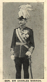
Photograph (black & White), General Sir Charles Warren - South Africa
General Sir Charles Warren was an officer in the British Royal Engineers. He was one of the earliest European archaeologists ofthe Holy Land. Much of his military service was spene in British South Africa. Previously he was police chief, the Head of the London Metropolitan Police during the Jack the Ripper murders. In 1876, the Colonial Office appointed him special commissioner to survey the boundary between Griqualand West and the Orange Free State. For this work he was made a Companion of the Order of St Michael and St George in 1877. He was appointed special commissioner to investigate "native questions" in Bechuanaland and commanded the Northern Border Expedition troops in quelling the rebellion there. In 1879 he became Administrator of Griqualand West. The town Warranton in the Northern Cape Province of South Africa is named after him. In 1882 the Admiralty sent him to Sinai to discover what had happened to Professor Edward Palmer's archaeological expedition. He discovered the members had been robbed and murdered, located their remains and brought their killers to justice. For this he was created a Knight Commander of the Order of St Michael and St George in 1883 , also Knight of Justice of the Order of St John of Jerusalem and in 1884 elected a Fellow of the Royal Society. In 1884 Warren was sent as HM Special Commissioner to command a military expedition to Bechuanaland, to assert British sovereignty in the face of encroachments from Germany and the Transvaal and to suppress the Boer freebooter states of Stellaland and Goshen, which were backed by the Transvaal and were stealing land and cattle from the local Tswana tribes. This became known as the Warren Expedition and achieved its aims without bloodshed. Warren was recalled and in 1885 was made Knight Grand Cross ofthe Order of St Michael and St George. In 1885 Warren stood for election for Parliament but lost the vote. In 1886 he was appointed Commissioner of Police of the Metropolis following Sir Edmund Henderson's resignation. Criticised continually for his decisions and actions he resigned in November 1888. Prior to this time he was appointed Knight Commander of the Order of the Bath, January 1888. On the outbreak of the Boer War in 1899 he returned to service and commanded the 5th Division of the South African Field Force. In January 1990, Warren bungled the second attempted relief of Ladysmith at Tugela River. At the Battle of Spion Kop, January 1990 he had operational command and his failure of judgement, delay and indecision despite his superior forces culminated in the disaster. It has been said that Warren was "perhaps the worst" of the British generals in the Boer War and certainly the most "preposterous". Redvers Buller in a letter to his wife described him as "a duffer", responsible for him losing him "a great chance". Warren was recalled to Britain in August 1900 and never again commanded troops in the field. Individual image from photographed poster of tobacco and cigarette cards.holy land, sir charles warren, british royal engineers, archaeologist, british south africa, london metropolitan police, jack the ripper, colonial office, commissioner, griqualand west, orange free state, companion of the order of st michael and st george, bechuanaland, northern border expedition, warrenton, sinai, professor edward palmer, knight commander of the order of st michael and st george, knight of justice of the order of st johnof jerusalem, fellow of the royal society, knight grand cross of the order of st michael and st george, boer war, redvers buller, knight commander of the order of the bath -
 Federation University Historical Collection
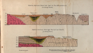
Booklet, Luplau, Hewood & Riderm Printers, The School of Mines Ballaarat Annual Report 1883, 1883
... , mathematics f. m. krause, land, mining and engineering surveying w. d ...The School of Mines Ballaarat. Annual Report 1883. Statement of Receipts and expenditure, general balance sheet, and list of subscriptions donations 1882. Sketch of School of Mines. Sketch Section from Lal Lal to the Moorabool (looking north) Geological map of Lal Lal. In the County of Grant. Annual Report, Balance Sheet, Certificates granted by the Council, Examination Papers - Elementary Science Classes (Appendix), Extracts from Visitors' Book, Fees, Form of Bequest, Honorary Correspondents. Life Governors, Museum - open to visitors, Notes on the Geology of Lal Lal (with Geological Plan & Sections), Obituary, Office Bearers, Paper of Particulars, Rules of the Ballaarat Field Club and Science Society (Appendix), Report of the Curator of the Museum and Library, Report of the Superintendent of Laboratories, Report of the Lecturer in Mathematics, Report of the Lecturer in Mechanical Engineering, Report of the Lecturer in Telegraphy, Report of the Lecturer in Materia Medica, Statement of Receipts and Expenditure for the year 1882, Subjects and Lectures, Subjects and Examiners, Subscriptions and Donations, from 1st January to 31st December 1882.Ballaarat School of Mines annual Report. Hard cover red book of 101 pages. Includes plans on Lal Lal and surrounds. ballarat school of mines, annual report, balance sheet, certificates granted by the council, examination papers, extracts from the visitors' book, fees, form of bequest, honorary correspondents, life governors, museum, notes on the geology of lal lal, obituary: charles william thomas. one of the examiners in mining and surveying, office bearers, paper of particulars, rules of the ballaarat field club and science society, report of the curator of the museum and library, report of the superintendent of laboratories, report of the lecturer in mathematics, report of the lecturer in mechanical engineering, report of the lecturer in telegraphy, report of the lecturer in materia medica, statement of receipts and expenditure for the year 1882, subjects and lectures, subjects and examiners, subcriptions and donations, from 1st january to 31st december 1882, alf. mica smith, professor of chemistry, alf. mica smith, metallurgy, f. m. krause - professor of geology, mineralogy, scientific mining, t. h. thompson, practical mining, w. h. shaw mechanical engineering, h. reid, mechanical enginnering, phoenix foundry company (limited), a. a. buley, mathematics, f. m. krause, land, mining and engineering surveying, w. d. campbell, telegraphy, james oddie, vice-president, alf. mica smith, natural philosophy (elementary mechanics and hydrostatics, magnetism and electricty, sound, light and heat), j. f. usher, materia medica, pharmacy and physiology, examiner, professor h. m. andrew, m. a., examiner, h. d. de la poer wall, m. a, c. e., examiner, thomas mann, b. a., examiner, p. c. fitzpatrick, c. s., examiner, h. rosale, j.p., f.g.s, m.e. and m, examiner, john lewis, examiner, w. c. kernot, m.a., c.e., examiner, professor mccoy, examiner, j. cosmo newbery, c.m.g., b. sc., examiner, baron von mueller, k.c.m.g., m. et ph. d., f. r.s., examiner, sam. w. macgowan, examiner, w. p. bechervaise, examiner, r. l. j. ellery, f.r.s. govt. astronomer, examiner, f. m. krause, c.e., examiner, j. m. bickett, examiner, n. kent, examiner, a. martin, examiner, r. s. mitchell, examiner, w. h. keast, examiner, p. matthews, examiner, d. milliken, examiner, j. t. richards, examiner, jonathan robinson, examiner, t. h. thompson, examiner, h. brookes allen, m.d., examiner, joseph bosisto, examiner, c. r. blackett, m.l.a., examiner, wm. johnson, analyst to the government of victoria, ferdinand krause, ballarat field naturalists club, ferdinand von mueller, thomas mann, a.a. buley, ferrdinand krause, alfred mica smith, james oddie, william johnson, jonathan robinson, james bickett, r.l.j. ellery, cosmo newbery, ballarat field naturalists -
Federation University Historical Collection
Booklet, The School of Mines, Ballaarat, Annual Report 1881, 1882
... mining, land, mining and engineering surveying t. h. thompson ...The School of Mines Ballaarat Annual Report 1881. Annual Report, Additional Examination Statute, Certificates Granted by the Council, Copy of letter received from the Honble. Francis Ormond, M.L.C., Extracts from the Visitors' Book, Fees, Form of Bequest, Life Governors, Museum - open to Visitors', Office Bearers, Paper of Particulars, Report of the Curator of the Museum and Library (with plans), Report of the Superintendent of Laboratories, Report of the Lecturer in Telegraphy, Report of the Lecturer in Mechanical Engineering, Statement of Receipts and Expenditure for the year 1881, Subjects and Lecturers, Subjects and Examiners, Subscriptions and Donations from 1st January to 31st December 1881, The Lignite Deposit at Skipton (with Section and Plan)Soft covered pale green booklet of 63 pages.annual report, additional examination statute, certificates granted by the council, copy of letter received from the honble. francis ormond, m.l.c., extracts from visitors' book, fees, form of bequest, paper of particulars, life governors, museum, officer bearers, report of the curator of the museum and library, report of the lecturer in telegraphy, report of the lecturer in mechanical engineering, statement of receipts and expenditure for the year 1881, subjects and lecturers, subjects and examiners, subscriptions and donations from 1st january to 31st december 1881, the lignite deposit at skipton, james oddie, esq., j.p., alf. mica smith, lecturer in chemistry, natural philosophy and botany, f. m. krause, lecturer in geology, scientific mining, land, mining and engineering surveying, t. h. thompson, lecturer in practical mining, w. h. shaw, lecturer in mechanical engineering, h. reid, lecturer in mechanical engineering, a. a. buley, lecturer in mathematics, w. d. campbell, lecturer in telegraphy, j. f. usher, lecturer in materia medica, pharmacy and physiology, a.a. buley, w.d. campbell, j.f. usher, w.h. shaw, ferdinand krause, t.h. krause, skipton lignite deposit, skipton coal, ballarat school of mines annual report -
Federation University Historical Collection
Booklet, A. A. Herberte, "STAR' Printing Works, The School of Mines, Ballaarat, Annual Report 1884, 1885
... , scientific mining, land, mining and engineering surveying t. h ...The School of Mines Ballaarat Annual Report 1884. Annual Report, Balance Sheet, Certificates Granted by the Council, Examination Papers - Elementary Science Classes (Appendix), Fees, Honorary Correspondents, Life Governors, Museum - open to Visitors', Office Bearers, Report of the Curator of the Museum and Library, Report of the Lecturer in Mathematics, Report of the Lecturer in Mechanical Engineering, Report of the Lecturer in Electricity and Magnetism, Report of the Lecturer in Telegraphy, Report of the Lecturer in Botany, Report of the Lecturer in Materia Medica and Physiology, Report of the Lecturer in Astronomy, Scale of Charges for Assays and Analyses, Examinations Held, Statement of Receipts and Expenditure for the year 1884, Statement of Receipts and Expenditure for Special Funds, Subjects and Lecturers, Subjects and Examiners, Subscriptions and Donations from 1st January to 31st December 1884, Time TableSoft covered pale green booklet of 67 pages. The Ballarat School of Mines Annual Report for 1984.annual report, balance sheet, certificates granted by the council, examination papers - elementary science, fees, honorary correspondents, life governors, museum, officer bearers, report of the curator of the museum and library, report of the lecturer in telegraphy, report of the lecturer in mechanical engineering, report of the lecturer in astronomy, scale of charges for assays and analyses, examinations held, statement of receipts and expenditure for the year 1884, statement of receipts and expenditure for special funds, subjects and lecturers, subjects and examiners, subscriptions and donations from 1st january to 31st december 1884, time table, james oddie, esq., j.p., alf. mica smith, lecturer in chemistry, natural philosophy and botany, f. m. krause, lecturer in geology, scientific mining, land, mining and engineering surveying, t. h. thompson, lecturer in practical mining, j. sommers, lecturer in mechanical engineering, h. sutton, lecturer in mechanical applied electricity and magnetism, a. a. buley, lecturer in mathematics, w. d. campbell, lecturer in telegraphy, j. f. usher, lecturer in materia medica, pharmacy and physiology, geo. day, lecturer in botany, john wall, lecturer in astronomy, subscriptions, fonations, telegraphy, henry sutton, usher, george day -
Federation University Historical Collection
Booklet, Rider & Mercer, The School of Mines, Ballaarat, Annual Report 1885, 1886
... . krause, lecturer in geology, scientific mining, land, mining ...The School of Mines Ballaarat Annual Report 1884. Annual Report, Balance Sheet, Certificates Granted by the Council, Fees, Honorary Correspondents, Life Governors, Museum - open to Visitors', Office Bearers, Report of the Curator of the Museum and Library, Report of the Superintendent of Laboratories, Report of the Lecturer in Mathematics, Report of the Lecturer in Mechanical Engineering, Report of the Lecturer in Electricity and Magnetism, Report of the Lecturer in Telegraphy, Report of the Lecturer in Botany, Report of the Lecturer in Materia Medica and Physiology, Report of the Lecturer in Astronomy, Scale of Charges for Assays and Analyses, Examinations Held, Statement of Receipts and Expenditure for the year 1885, Statement of Receipts and Expenditure for Special Funds, Subjects and Lecturers, Subjects and Examiners, Subscriptions and Donations from 1st January to 31st December 1885, Time TableSoft covered pale grey booklet of 72 pages.annual report, balance sheet, certificates granted by the council, fees, honorary correspondents, life governors, museum, officer bearers, report of the curator of the museum and library, report of the superintendent of laboratories, report of the lecturer in telegraphy, report of the lecturer in mechanical engineering, report of the lecturer in electricity and magnetism, report of the lecturer in botany, report of the lecturer in materia medica and physiology, report of the lecturer in astronomy, scale of charges for assays and analyses, examinations held, statement of receipts and expenditure for the year 1885, statement of receipts and expenditure for special funds, subjects and lecturers, subjects and examiners, subscriptions and donations from 1st january to 31st december 1885, time table, james oddie, esq., j.p., alf. mica smith, lecturer in chemistry, natural philosophy and botany, f. m. krause, lecturer in geology, scientific mining, land, mining and engineering surveying, t. h. thompson, lecturer in practical mining, john sommers, lecturer in mechanical engineering, henry sutton, lecturer in mechanical applied electricity and magnetism, henry j. hall, freehand drawing, a. a. buley, lecturer in mathematics, w. d. campbell, lecturer in telegraphy, j. f. usher, lecturer in materia medica, pharmacy and physiology, george day, lecturer in botany, john wall, lecturer in astronomy, charles kent, auditor, andrew berry, registrar, alfred mica smith, james oddie, ferdinand krause, t.h. thomson, john sommers, nery sutton, w.d campbell, telegraphy, henry hall, george day, john wall, j.f. usher, charles kent, andrew berry, a.a. buley -
Federation University Historical Collection
Book, Tourism at the University of Ballarat - 1996 AH&TE Conference: Historic Mining Site Management, 1996
Tourism at the University of Ballarat - 1996 AH&TE Conference: Historic Mining Site ManagementWhite soft covered folder. mary hollick, public land in victoria, heritage legislation commonwealth, management issues, list of key mining heritage trails, preliminary market research, survey locations, university of ballarat, school of business, historic mining site, historic mining site management, tourism, mining heritage trails -
Federation University Historical Collection
Booklet, Berry Anderson & Co, The Ballarat School of Mines, Calendar and Annual Report 1894, 1894
... . horwood - mine and land surveying, mining mechanics, hydraulics ...The Ballarat School of Mines Calendar and Annual Report 1894. Associateship of The School, Calendar for 1894, Certificates Granted by the Council 1893, Comparative Statement of Receipts and Expenditure, Departmental Expenditure, Examiners, Examination Papers, Examination Fees, Fees, Honorary Correspondents, Life Governors, Meteorological Observations, Mining Engineering Scholarship, Number of Certificates Granted since Inception, Number of Students attended The School of Mines, Office Bearers, Plant and Appliances, Practical Treatment of Ores, Professors and Lecturers, Report of the Professor of Mineralogy and Geology and Curator of the Museum, Report of the Superintendent of Laboratories, Report of the Lecturer on Engineering and Surveying, Report of the Lecturer on Mathematics, Report of the Instructor in Mechanical Drawing and Machine Construction and Design, Report of the Lecturer on Electrical Engineering and Telegraphy, Report of the Lecturer on Geometrical Model and Perspective Drawing, Report of the Lecturer on Botany, Report of the Lecturer on Biology, Pharmacy, Materia Medica, Scale of Charges for Assays and Analyses, State School Science Classes, Statement of Receipts and Expenditure for year 1893 and Serjeant Scholarship Fund, Statistics - Student attending Lectures, Subscriptions and Donations, Syllabus of Lecture Courses, Time TableThe Ballarat School of Mines Calendar and Annual Report, 1894. Green soft cover, 116 pages. ballarat school of mines, annual report, andrew anderson j.p. - president, f. j. martell - vice president, r. denham pinnock - vice president, rivett henry bland - trustee, the hon. sir w. j. clarke - trustee, the hon. john warrington rogers - trustee, james oddie - trustee, the hon. henry cuthbert - honorary solicitor, r. g. middleton - honorary treasurer, charles kent - auditor, andrew berry - registrar, professor alf. mica smith - chemistry, metallurgy, natural philosophy, professor krause - geology, mineralogy, principles of mining, professor j. h. horwood - mine and land surveying, mining mechanics, hydraulics, civil engineering, applied mechanics, j. a. dawson - electrical engineering, d. walker - chemistry and natural philosophy, w. e. bennetts - mathematics, henry j. hall - freehand and perspective drawing, a. e. c. kerr - mechanical drawing, george p. day - botany, e. gutheil - paleontology, zoology, materia medica, w. d. snowball - veterinary science -
Federation University Historical Collection
Booklet, Berry Anderson & Co, The Ballarat School of Mines, Calendar and Annual Report 1895, 1895
... . Dawbarn - mine and land surveying, mining mechanics, hydraulics ...The Ballarat School of Mines Calendar and Annual Report 1895. Associateship of The School, Calendar for 1895, Certificates Granted by the Council 1894, Certificates Granted by the Education Department 1893, Comparative Statement of Receipts and Expenditure, Departmental Expenditure, Examiners, Examination Papers, Examination Fees, Fees, Honorary Correspondents, Life Governors, Meteorological Observations, Number of Students attended The School of Mines, Obituary, Office Bearers, Practical Treatment of Ores, Professors and Lecturers, Report of the Professor of Mineralogy and Geology and Curator of the Museum, Report of the Superintendent of Laboratories, Report of the Lecturer on Engineering and Surveying, Report of the Lecturer on Mathematics, Report of the Instructor in Engineering and Machine Construction and Design, Report of the Lecturer on Electrical Engineering, Report of the Lecturer on Geometrical Model and Perspective Drawing, Report of the Lecturer on Botany, Report of the Lecturer on Palaeontology, Materia Medica and Mining Ambulance, Scale of Charges for Assays and Analyses, Statement of Receipts and Expenditure for year 1894, Statistics - Student attending Lectures, Subscriptions and Donations, Syllabus of Lecture Courses, Time TableThe Ballarat School of Mines Calendar and Annual Report, 1895. Pale brown soft cover, 90 pages. ballarat school of mines, annual report, andrew anderson j.p. - president, f. j. martell - vice president, r. denham pinnock - vice president, the hon. sir w. j. clarke - trustee, the hon. john warrington rogers - trustee, the right reverend samuel thornton - trustee, andrew anderson - trustee, james millhinch - trustee, james oddie - trustee, the hon. henry cuthbert - honorary solicitor, r. g. middleton - honorary treasurer, charles kent - auditor, andrew berry - registrar, professor alf. mica smith - chemistry, metallurgy, natural philosophy, professor krause - geology, mineralogy, principles of mining, professor g. j. dawbarn - mine and land surveying, mining mechanics, hydraulics, civil engineering, applied mechanics, j. rowe - practical mining, j. a. dawson - electrical engineering, d. walker - chemistry and natural philosophy, w. e. bennett - mathematics, henry j. hall - freehand and perspective drawing, a. e. c. kerr - mechanical drawing (machine construction and design), george p. day - botany, e. gutheil - paleontology, zoology, materia medica, rivett henry bland - obituary, george gant scott - obituary, fiddian, bennett, r. allan, dawbarn, rosales, krause, joseph bryant, matthews, j. robinson, andrew robertson, john lynch, jonathan robinson, a.e.c. kerr, alfred mica smith, frederick mccoy, j. cosmo newberry, blackett, elelry, arnot, robert allan, bickett, kent, martin, mitchell, ferdinand von mueller, rivett henry bland, thomas bath, john rowe, museum, andrew anderson, george day, subscriptions and donations, examination papers -
Federation University Historical Collection
Booklet, General Syllabus of Examinations Science and Trade Subjects Technical Schools, 1906, 1906
... carpentry joinery chemistry coach building cookery dressmaking land ...Education Department of Victoria, "General Syllabus of Examinations in Science and Trade Subjects", published in 1906. A O Sachse was the Minister of Public Instruction and Frank Tate was the Director of Education.Green soft cover booklet holding the general syllabus of examinations in Science and trade Subjects in Technical Schools.education department victoria, syllabus, examinations, science, trade, technical schools, a.o. sachse, frank tate, agriculture, algebra, applied mechanics, arithmetic, assaying, blacksmithing, botany, carpentry, joinery, chemistry, coach building, cookery, dressmaking, land surveying, metallurgy, mineralogy, mining, plumbing, printing, wool sorting, minister of public instruction, director of education, 1904 -
 Federation University Historical Collection
Letter - Correspondence, Inwards correspondence to the Ballarat School of Mines, 1908, 07/01908
... railways telegraph land surveying j. brittain g. fitzgerald ...The Ballarat School of Mines was the first school of Mines in Australasia, and was established in 1870. It is a predecessor institution of Federation University Australia.Correspondence to the Ballarat School of Mines for the month of July 1908. Letter 162 Ballarat Fine Art Public Gallery Association 19 Lydiard Street North Ballarat, 26th June 1908 Sir, I am directed to inform you that at a meeting of the Council of the above held last evening, your previously acknowledged letter of 11th June 1908, addressted to "E. [Stoer?] Esq, President Late Technical Art School Committee", was received and referred to a committee for its report thereon, cousi directions of which was made are the Order of the Day for the Councils next Ordinary Monthly Meeting. I am, Sir, Your Obedient Servant, J.A. Powell Secretary F.J. Martell Esq Director The Ballarat School of Mines Ballarat ballarat school of mines, frederick martell, ballarat fine art gallery, j.a. powell, art gallery of ballarat, gallery association, charles j. morris, ballarat fine art public gallery association, telegram, c.h. clark, l. ditchburn, alumni, examinations, w.g. taylor, london bank of australia limited, bealiba, thomas r. lyle, jessie chalmers, signor steffani, arundel orchard, w.f. coltman, e.e. hobson, j.t. mooney, queanbeyan, p.e. marmion, willaim m. robertson, assay, e.e. brook, lloyd copper mines, h.b. silberberg & co., education department melbourne, c. james, w. west, haddon, warragul, bakers reef gold mning company, letterhead, victorian portland cement works, d. mitchell, electric lighting and traction co. australia ltd, austral otis engineering comapny ltd, melbourne glass bottle works company, cuming, smith & co. pty ltd, excursions, metropolitan gas company, jaques bros manufacturing engineers, victoria iron works, a. victor leggo co, leggo's metallurgical works, melbourne hydraulic power company limited, mount lyell mining and railway coy ltd, victorian railways, telegraph, land surveying, j. brittain, g. fitzgerald, hamilton, cochran and co, wynne-grant antimony reduction company, mt egerton and gordons mining co, e. hogan, e.c. connell, a.d. galoway, metallurgy, h.b. silberberg, specific gravity balance and weights, union bank of australia (ballarat), bullarto, bush inn, bullarto, w. harrington, prospective student, book donaton from smithsonian institution, e. la t. armstrong, department of mines and forests, melbourne, snake valley, r. hall-jones, c. calaby, clementston, thomas ramsay, w.d. thompson, longmans, green and co, selwyn chase, missionary exhibition, aboriginal court of the missionary exhibition, examination results, leslie coulter, hnery j. saw, thomas ramsay, virgil tucker, leslie c. blick, thomas r. williams, oliver w. williams, thomas r. williams, leo m. seward, david w. bonar, louis w.g. buchner, leo m. seward, albert j. robin, james a. chambers, james d. brokenshire, william kingston, edgar c. hurdsfield, virgil tucker, oliver w. williams, william g. sides, herbert hawkesworth, colin c. corrie, henry j. saw, thomas h. trengrove, thomas r. prigdeon, harold b. herbert, viola p. jackson, lionel s. davies, stanley w. tompkins, arthur m. lilburne -
Federation University Historical Collection
Book, Jacobs Lewis Vines Architects and Conservation Planners, Historic Sites Survey: Ballarat Study Area, 1980, 1980
This survey was commissioned by the Land Conservation Council, Australian Heritage Commission and the Ministry for Conservation 114 page report on historic sites in the Ballarat region. It includes information on sites, a schexdule of sites, silte selection and designated areas (ie around towns)historic sites, ballarat, wendy jacobs, miles lewis, gary vines, berringa, buninyong, creswick, dunnstown, fiery creek, lal lal, langi logan, cathcart, mount cole, mount egerton, nerrina, gong gong, wombat state forest, railways, explorers routes, early roads, land conservation council, ausralian hertiage commission, department of planning, icomos (burra) charter, nigel lewis, richard aitken, freehold land, public land, langi ghiran, new jubille mine, birthday tunnel mine, pitfield plains, smythesdale, buninyong company, mount clear, mt clear, canadian gully, warrenheip distillery, thomas mitchell, waterloo, trawalla, beaufort, raglan, internment camps, forestry, mining, mining, mt egerton, mary hollick collection, jubilee mine, burra charter, historica areas data form, explorers, egerton company, black horse mine, mt egerton government battery, kaolin mines, anderson brothers, barkstead, anderson's tramway, clarkesdale, berry leads, birthday tunnel mine berringa, warrenheip, australasian company, mount mercer, lanvi-kal-kal, water race -
 Federation University Historical Collection
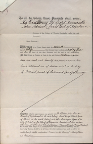
Documents, Appointment of New Trustees of the Ballarat School of Mines and Industries, 1894, 1894
A deed appointing the Reverend Samuel Thornton as a trustee of the Ballarat School of Mines, after the death of former Trustee Rivett Henry Bland, and increasing the number of trustees by appointing James Millhinch Bickett. It includes a covering letter of Department of Lands and Survey Letterhead... and whereas it is intended that forthwith after the execution hereof the said land and premises shall be so transferred that the same may become vested in the said Sir William John Clarke and John Warrington Rogers jointly with the said Right Reverend Samuel Thornton, Andrew Anderson and James Millhinch Bickett now these prexsents witness that the said Governor as such Governor as aforesaid in exercise of the power for this purpose given to him by the said Crown Grant and of every other power enabling him doth hereby appoint the Said Right Reverend Samuel Thornton to be a trustee of the land in place of the said Rivett Henry Bland and James Millhinch Bickett to the addition trustees. .. .department of lands and survey, letterhead, legal, john adrian louis earl of hopetoun, william john clarke, rivett henry bland, john warrington rogers, trustees, ballarat school of mines, ballarat school of mines trustees -
 Federation University Historical Collection
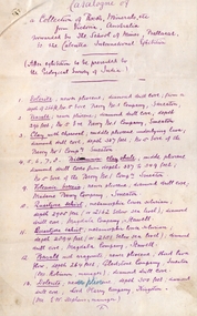
Document, SMB: Catalogue of a Collection of Rocks, Minerals, etc, 1883
This list of rocks, minerals, etc. from Victoria was complied and forwarded by the School of Mines, Ballarat, to the Calcutta International Exhibition. At the end of the exhibition the items were to be presented to the Geological Survey of India. One Hundred items are listed. Pages 4 and 5 also show diagrams relating to the land formations and sections. Places in Victoria are named indicating where items were found. List compiled by Professor Ferdinand Moritz Krause. He joined Ballarat School of Mines in 1880 and lectured in Mineralogy and Geology. He was also the Curator of the Ballarat School of Mines Museum.6 pages, handwrittenSignature of F M Krause Dated 30th August 1883ballarat school of mines, rocks, minerals, calcutta international exhibition, geology survey of india, victoria, professor ferdinand moritz krause, mineralogy, geology, curator, ballarat school of mines museum -
 Ringwood and District Historical Society
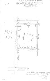
Document - Copy of Lands Department Field Notes - Parish of Ringwood, Victoria, Field Notes 1917/137 - Part of O.P. R72 - Allotment 10, surveyed June 1917
5613b Foolscap size photocopy of survey map with handwritten notations. References include Knight's land, Wantirna Road, Canterbury Road, house, wirenetted, orchard, grass paddock, I certify that these notes are a true copy of observations and measurements taken on the ground by me (signed) H.W. Moore 5/6/17. -
 Ringwood and District Historical Society
Map, Plan of Country Lands in the Parishes of Nunawading Ringwood and Scoresby - circa 1855
... "Surveyed and plotted by N.M. Bickford, Superintendant...". "The land comprised in this survey is of inferior quality ...Blueprint copy of Survey Map detailing original Selectors' names and property locations. List of Parish map references including property bearings, distances in Links, and markings on trees. Descriptive remarks include areas marked "Farmer's Common", "Poor soil thickly/moderately timbered with stringy bark", and location of water and firewood reserves."Surveyed and plotted by N.M. Bickford, Superintendant of Mr. Hodgkinson's Field Party". "The land comprised in this survey is of inferior quality, moderately undulating, and thickly wooded. It is watered by Dandenong Creek and Deep Creek." Inset map showing location of (*proposed) cemetery on southern corner of Lillydale Road from Melbourne and Sawmill Road, later Mount Dandenong Road. (*Cemetery did not eventuate.) -
 Ringwood and District Historical Society
Newspaper, Scrapbook Clipping, Library Collection, Ringwood, Victoria
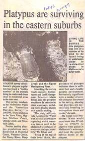
Newspaper Clipping from "The Post", 14 January 1997, Page 11, "Platypus are surviving in the eastern suburbs"'.A major survey of Melbourne's platypus population has found a "healthy number" of the animals living in creeks and rivers close to residential area in the outer east. Conservation and Land Management Minister, Marie Tehan, was present at the launching of the survey results, and spoke in detail about the results and the future planning and financial aid for the health of the Melbourne waterways. -
 City of Moorabbin Historical Society (Operating the Box Cottage Museum)
Photograph, black & white George Box 1808- 1867, c1855
George Box 1808-1867 an 'agricultural labourer', of Sussex England, married Mary Cripps in 1831 and with 3 three of their 4 four sons and 3 three of their 4 four daughters left Liverpool in the Sailing Ship 'Atlanta' in March 1856 to begin a new life in Melbourne, Victoria , Australia. George and son Henry paid their own fares while sons , Francis and John, were 'assisted passengers'. Their baby daughter Cecilia Lydia died a few days into the voyage.. Caroline Box, the eldest daughter, remained in England working as a cook until she joined the family in Australia in 1863. William Box 1834-1902, the eldest son of George Box, married Elizabeth Avis 1833- 1914 and they resided in Box Cottage 1865 -1914 where they established a market garden and raised 13 children. William and Elizabeth had emigrated in 1854 so George and sons probably worked on their market garden before setting up in Tucker Road and Patterson Road. Sadly Mary drowned in a water hole only 4 months after their arrival in Brighton. Mary suffered from headaches and had occasional fits and the coroner found she passed out and died while trying to ease the pain with cold water from a waterhole. It is supposed that Elizabeth helped him raise the children while he established his market garden. George died from Tetanus following an infected broken leg caused by falling from his dray in 1867. George and Mary were both buried in the Brighton Cemetery. Box Cottage Museum, a reconstruction of an early settler hut, is named after the Box family who resided there 1865 -1913 . George Box was the father of William Box who with his wife Elizabeth Avis Box and 13 children lived and farmed on the block of land in Jasper Road, East Brighton ( now McKinnon / Ormond) that was part of the Henry Dendy Special Survey 1841 Inscribed in Album : “ The early photos in this album were found by Mr (Laurie) Lewis when he was demolishing the Old Box Cottage. He gave them to Mrs Avis Box Eldridge who in turn gave them to me. They were not identified. I believe they rightly belong in the Cottage. I have attempted to identify them and present them in a way they can be preserved as a historical record of the era.” A B Leigh A black and white photograph of George Box taken in Tunbridge Wells, England c1855Photo at base ; TUNBRIDGE WELLS Album inside cover ; Donated to / Moorabbin / Historical Society / by / Avis Box Leigh box george, box mary, box william, box elizabeth, box alonzo, box mary louisa, dendy henry, were j b, dendy's special survey 1841, brighton, moorabbin, bentleigh, mckinnon, ormond, market gardeners, dairy farms, early settlers, pioneers, jasper road, gurr jabez, gurr eliza, pay henry, pay anna, ward willam, box henry, ward elizabeth emma, box john, sheldrake martha, rushall eleanor, box caroline, tetanus -
 City of Moorabbin Historical Society (Operating the Box Cottage Museum)
Photograph - Photograph, Black & White, Caroline Box c1855, c1855
George Box, of Sussex England, his wife Mary Cripps Box and 3 three of their 4 four sons and 3 three of their 4 four daughters left Liverpool in the Sailing Ship 'Atlanta' in March 1856 to begin a new life in Melbourne, Victoria , Australia Their baby daughter Cecilia Lydia died a few days later. Caroline Box, the eldest daughter, remained in England . working as a cook until she joined the family in Australia in 1863 Box Cottage Museum, a reconstruction of an early settler hut, is named after the Box family who resided there 1865 -1913 . George Box was the father of William Box who with his wife Elizabeth Avis Box and 13 children lived and farmed on the block of land in Jasper Road, East Brighton ( now McKinnon / Ormond) that was part of the Henry Dendy Special Survey 1841 Black and white photograph of Caroline Box taken in Tunbridge Wells England c 1855Album inside cover ; Donated to / Moorabbin / Historical Society / by / Avis Box Leighbox george, box mary, box william, box elizabeth, box alonzo, box mary louisa, dendy henry, were j b, dendy's special survey 1841, brighton, moorabbin, bentleigh, mckinnon, ormond, market gardeners, dairy farms, early settlers, pioneers, jasper road, gurr jabez, gurr eliza, pay henry, pay anna, ward willam, box henry, ward elizabeth emma, box john, sheldrake martha, rushall eleanor, box caroline