Showing 6985 items
matching service roads
-
 Ringwood and District Historical Society
Obituary, Order of Service for the celebration of the life of Muriel Evelyn McGivern, and Mail article. 2000, Jan-00
1. Order of Service for the celebration of the life of Muriel Evelyn McGivern.; 2. Cutting from Mail 8-Feb-2000 +Additional Keywords: McGivern, Muriel'Writer takes last volume to heaven' -
Ringwood and District Historical Society
Newspaper clippings, Fairfax Community Newspapers, Two newspaper cuttings from the Maroondah Journal newspaper Tues 27-Sep-2005 with article and picture regarding Ringwood Ladies Benevolent Society closing after 75 years of community service, 27-Sep-05
This is the write-up in the local newspaper about the closure of the Ladies Benevolent Society after 75 years of service to the community.Two newspaper cuttings from the Journal newspaper Tues 27-Sep-2005; 1. Noble Farewell - a short article with pictures of members of the Ladies Benevolent Society; 2. Apathy kills old charity -
Ringwood and District Historical Society
Pamphlet, Ringwood Area pamphlets and promotional material. 2006, 2006
They include Maroondah Police Seniors Register, The Kerrabee Club Planned Activity Group, Skate and BMX in Maroondah, Access 4 all 2 Play, Local Service Groups, Carolyn Gold Bug display (Maroondah Gallery); and maintaining Mobility in Ringwood.Collection of 8 pamphlets about activities in Ringwood.; They include Maroondah Police Seniors Register, The Kerrabee Club Planned Activity Group, Skate and BMX in Maroondah, Access 4 all 2 Play, Local Service Groups, Carolyn Gold Bug display (Maroondah Gallery); and maintaining Mobility in Ringwood. -
Ringwood and District Historical Society
Newspaper - Newsletters, Djerrnong Anglican Parish of Heathmont and Ringwood East: "Pews News" 2008, January 2008
Pews News created by the church to disseminate current news and information. This was the time that the final service at Ringwood East took place on 27-Jan-2008.Two issues of Pews News - 13 January 2008 and 20 January 2008, created by the church to disseminate current news and information. Pamphlets white bifold with black printing. Qty 2.; Djerriong - Anglican Parish of Heathmont and Ringwood East. -
Ringwood and District Historical Society
Booklet, Ringwood High School, Ringwood High School Song Book - c.1960s
Song book from Ringwood High School belonging to Elizabeth Vreeke - Form 1B.Song book from Ringwood High School belonging to Elizabeth Vreeke - Form 1B. Pale green covered booklet with brown printing and logo on front. Cream pages. 32pp. +Additional Keywords: Vreeke, ElizabethRingwood High School Culture and Service. Song Book. -
Ringwood and District Historical Society
Pamphlet, Australian Militia Forces (Home Defence) Conditions of Service c1939, c.1939
Given to potential applicants wanting to join any arm of service. Enquiry at any drill hall for conditions of service.Conditions of Service in the Australian Militia Forces. Home defence only. Cream bifold leaflet with blue printing and with rising sun crest above printing.Conditions of Service in the Australian Militia Forces. Home defence only. -
 Ringwood and District Historical Society
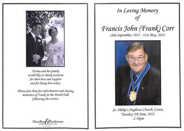
Programme, Funeral Service for Francis John (Frank) Corr. 1931-2012
Obituary written by the Corr family in memory of Frank Corr, a former Mayor of Ringwood as was his father. A well known Ringwood family.Bifold leaflet including order of service. -
Ringwood and District Historical Society
newspaper cutting, The Mail, Ringwood rail services Newspaper Cuttings 1993-1996, 1993-1996
Newspaper cuttings on Railways glued to 8 A4 1993-1996. Various topics relating to Ringwood rail services. -
 Ringwood and District Historical Society
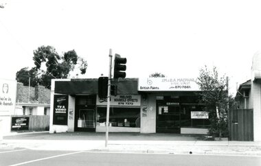
Photograph, Wantirna Road Shops, Ringwood, Victoria - 1993, 28-Feb-93
... Hardware and Wantirna TV and Video Service. Wantirna Road Shops ...Black and white photograph of group of shops in Wantirna Road Ringwood including McPhail Hardware and Wantirna TV and Video Service. -
Ringwood and District Historical Society
Documents, Court Recordings Services Pty Ltd, Eastland Development - Supreme Court Case transcripts 1963, 1963
Transcript of the court case in the Supreme Court of Victoria between 12 plaintiffs from the Ringwood Community and the defendants, the Mayor, Councillors and citizens of the City of Ringwood before Mr Justice Gillard. Started on 29-Jul-1963 and continued for several days.5 bundles of typed foolscap pages - transcript of the court case in Supreme Court of Victoria in 1963 pertaining to the development of Eastland. 4 bundles in faded green folders Vol.1-4. +Additional Keywords: Gillard, Mr Justice -
Ringwood and District Historical Society
Document - Programmes, Norwood Secondary College events including stage productions, VCE lists 1994-95
Part of the collection from Norwood Secondary High School which was renamed Norwood Secondary College in the late 1980s3 programmes for musicals "Birds of a feather"1992, "Grease" 1994, "Copacobana" 2002. 2 Valedictory dinner programmes 1994 1995 "Norwood Remembers "1995 Appreciation of voluntary service 2001 Inaugural Deb Ball programme -
Ringwood and District Historical Society
Pennant, Screencraft, FJ6510, Ringwood High School Pennant c1960, c.1960
Given to the Society by Gordon Hoskin who attended Ringwood High.Green felt pennant with red felt edge and loops. Circular motif in cream with Ringwood High School culture and service in cream lettering and red lamp with flame in centre. Ringwood High is written towards the tapering end. +Additional Keywords: Hoskin, Gordon -
Ringwood and District Historical Society
Books, Ladies Benevolent Society, 1987 - 2005
The Ladies Benevolent Society was started in 1927 under the auspices of the Lady Mayoress and Councillors' wives to aid the wives and families of the poor and unemployed in times of need. In those days there was very little social support. The Society worked closely with the Citizens Advice Bureau after it started in 1967 until lack of volunteers and the improvement of social services reduced the need for the service.Collection of books from the former Ladies Benevolent Society comprising:; 2 account books; 2 treasurers petty cash books; 3 cash receipt books; 1 Ladies Benevolent stamp; 1 Marbig folder with memorabilia; 1 bundle depression letters +Additional Keywords: East, Lorna / Lavis, Audrey -
Ringwood and District Historical Society
Pamphlet, We Serve the Children
Presented to Mrs Proudly for her service to the Ringwood State School Mothers' Club between 1945 to 1955. A token of Appreciation.Copy of a document presented to Mrs Proudly for her service to the Ringwood State School Mothers Club between 1945 to 1955. A Token of Appreciation. White bifold pamphlet with insert; black printing; black front left edge and black printing. Photocopy. +Additional Keywords: Proudly, Mrs VVictorian Federation of Mothers Clubs: 'We Serve the Children' -
Ringwood and District Historical Society
Enrolment cards, Approximately 110 cards for Red Cross Emergency Service Ringwood Branch Company Enrolment used by local women. Yellow cards; name on front; details of training on back. 1939, 1939
Red Cross system cards of many well known local women enrolling in Red Cross in 1939 with details of their training.Approximately 110 enrolment cards for Red Cross Emergency Service used by local women. Yellow cards; name on front; details of training on back. -
Ringwood and District Historical Society
Document Folder, Hand covered bifold document folder belonging to Cr. A. Temple Miles J.P., Mayor of Ringwood 1924-1925, 1925-1926, 1926-1927, 1933-1934, 1934-1935, 1937-1938. Councillor 1924-1939 and 1946-1947, 1947
Presentation folder, recording the service A. Temple Miles gave to the Council of the Borough of RingwoodHand covered bifold document folder with pockets for documents and blotting paper. It belonged to Cr. A. Temple Miles J.P., Mayor of Ringwood 1924-1925, 1925-1926, 1926-1927, 1933-1934, 1934-1935, 1937-1938. He was a councillor 1924-1939 and 1946-1947. As in Brief Description, plus Borough of Ringwood at the top -
Ringwood and District Historical Society
Books (2), Penryn Printing Service Pty Ltd, Pounds Act 1958 - Ringwood Municipality copy, 1958
Two buff coloured books with heavy cloth and cardboard covers containing 15 pages of the 1958 Pounds Act with additional copy (not attached). Metal binding.Similar book with "Pound Act" on front - additional copy. +Additional Keywords: Penryn Printing1. Pounds Act; 2. Pound Act. -
Ringwood and District Historical Society
Leaflets, Salvation Army Press, Religion in School pamphlets, incl Ringwood Churches School Services Program for Education Week 1961, 1959-1961
Pamphlets given out by the Christian Education Council in schools.1. Booklets 'New Horizons' with grey and black cover and printing. pp. 16.; 2. Cream coloured bifold. Black printing. Education week 1961.; 3. As the twig is bent. Photo. Front. Brown printing.; 4. Green bifold black printing. -
Ringwood and District Historical Society
Papers, Minutes of various sub-committee meetings of Ringwood Council - 1960, 1960
Various committee meetings discussing badges, traffic movement on the Proclamation Day Saturday 19-Mar-1960 in the town hall, Ringwood list of visitors, Councillors; and|one printed civic service on Sunday 20-Mar-1960 at St Pauls Church of England commemorating Proclamation attended by Sir Dallas BrooksBundle of 34 foolscap pages, printed, of the minutes of various sub-committee meetings of Ringwood Council;; one printed notice paper for the special meeting; and; one printed order of service for Saturday 19-Mar-1960 +Additional Keywords: Lavis, Albert George / Brooks, Reginald Alexander Dallas -
Ringwood and District Historical Society
Envelope, Packet: Will/Grave Certificate Ellen French (1930), F. G> Arnott Papers, Auxiliary Fire Service, Clothing Ration Card 1947. William Alfred French Probate etc
Arnott: Miscellaneous Papers; Will; Federal Documents; Ration Card +Additional Keywords: Arnott -
Ringwood and District Historical Society
Envelope, Packet 1 St Paul's Anglican Church, Ringwood, 1894 - 1969
Various newsletters and local church records circa 1894 - 1969, including: Sunday School Anniversary Services programme, March 1894 Baptism card - Alice Sanders, August 1902 Collage of handwritten notes and newspaper clippings, 1898-1919 Photocopies of handwritten notes for historical walk - 5 pages Typewritten summary of early history of St. Paul's Church of England, Ringwood Handwritten notes and newspaper clippings on 10th birthday in 1962 of East Ringwood Holy Trinity Church of England Ladies' Guild 3779b Newspaper clipping - Lunch is on St. Paul's - Ringwood Mail 24 August 1994 (George Lawson) -
Ringwood and District Historical Society
Book, Penryn Printing Service Pty Ltd, "Dog Act", 1970
Buff coloured book with heavy covers containing 16 pages of the 1970 Dog Act with additional copy and 4 pages of amendments dated 19-Dec-1978 and 4 pages amendments dated 13-May-1980. Metal binding. +Additional Keywords: Penryn PrintingDog Act -
 Ringwood and District Historical Society
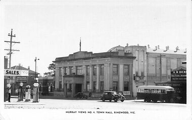
Photograph/Postcard, Postcard and souvenir photograph - Murray Views No. 4 - Town Hall, Ringwood, Vic
Black & white "Murray Views" postcard and souvenir photograph - Ringwood Town Hall Ringwood, Mathieson's service station petrol pumps on left, Real Estate Agent AW Dickson in JB McAlpin's office.Year 1948 handwritten on back of postcard. -
 Ringwood and District Historical Society
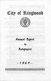
Pamphlet, F.P. Dwerryhouse, Town Clerk and Treasurer, City of Ringwood Annual Report To The Ratepayers - 1964, 1964
City of Ringwood community information report for 1964, including sections covering Valuations-Rates, Sanitary Service - Sewerage, Private Street Construction, Loughnan Hill Road Scheme, Other New Works, Planning Scheme, Fire Hazards, Fly Control, Dogs, Annual Special Clearance of Refuse, Garbage Removal, Immunisation, Street Lighting, House Numbers, Home Help, Scholarships, Rubbish Dumping, Vandalism, and list of Council Representatives.rinx -
 Ringwood and District Historical Society
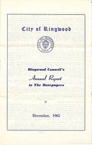
Pamphlet, F.P. Dwerryhouse, Town Clerk and Treasurer, Ringwood Council's Annual Report To The Ratepayers - December 1965, 1965
City of Ringwood community information annual report for 1965, including sections covering Ringwood Planning Scheme, Extensions to Lionswood Village, Building Activity, Private Street Construction, Other Road Works, Drainage Works, Town Planning, Retention of Native Flora, General Rate Notice, Sanitary Service Charge, Dandenong Valley Authority Rate, Decimal Currency Conversion, Children's Playgrounds, Annual Special Clearance of Refuse, Garbage Removal, Immunisations, Infant Welfare Centres, Home Help Service, House Numbering, Dogs, Horse Riding, Fire Hazards and Burning Off, Secondary School Grants, and list of Council Representatives.rinx -
 Ringwood and District Historical Society
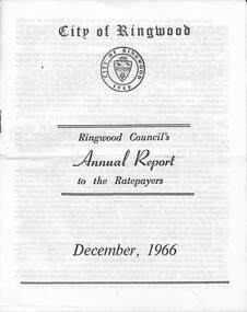
Pamphlet, F.P. Dwerryhouse, Town Clerk and Treasurer, Ringwood Council's Annual Report To The Ratepayers - December 1966, 1966
City of Ringwood community information annual report for 1966, including sections covering Finance, Sanitary Service Charge, Municipal Library, Memorial Clock Tower, Reserves, Civic Centre, Maroondah Highway Reconstruction, Other Road Works, Building Activity and Development - Education, MacRobertsons Pty. Ltd. & Travellers' Facilities (Ringwood Station), Appreciation - Decimal Currency Conversion, Annual Special Clearance of Refuse, Garbage Removal, Fly Control, Immunisations, Infant Welfare Centres, Retention of Native Flora, Home Help Service, Dogs, Horse Riding, Fire Hazards and Burning Off, Secondary School Grants, and list of Council Representatives.rinx -
 Ringwood and District Historical Society
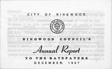
Pamphlet, F.P. Dwerryhouse, Town Clerk and Treasurer, Ringwood Council's Annual Report To The Ratepayers - December 1967, 1967
City of Ringwood community information annual report for 1966, including sections covering Finance, Rates & Charges, Commercial Projects, Municipal Library, Memorial Clock Tower, Private Street Construction, Advisory Service, Litter, Fire Hazards, Home Help Service, Immunisations, Infant Welfare Centres, Native Flora, Dogs, Horse Riding, Fly Control, Garbage Removal, Metropolitan Fire Brigade, Vandalism, Street Lighting, and list of departing and current Council Representatives.Mrs. Elizabeth Penny, representing the East Ward, made history in Ringwood by being the first woman elected to the Council, and subsequently as Ringwood's first lady Mayor.rinx -
 Ringwood and District Historical Society
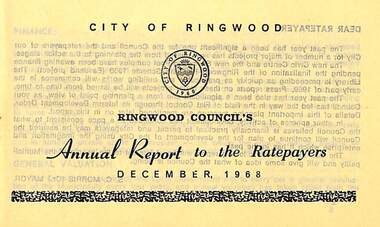
Pamphlet, Ringwood Council's Annual Report To The Ratepayers - December 1968, 1968
City of Ringwood community information annual report for 1968, including sections covering Finance, General Valuation and Rater Payments, Property Ownership Changes, Refuse, Sanitary Serviced, Sewerage Connections to MMBW, Dandenong Valley Authority, Residential Flat Control Planning Scheme, Immunisation, Home Help, Elderly Citizens' Clubrooms, Library, Civic Centre, Golf Course, Sale of Council Land, Swimming Centre, Holiday Play Centre, Civic Week, Lake Reserve Improvements, Rubbish Dumping, Street Trees, Vandalism, White Ants, Street Construction, Fire Hazards, Dog Nuisance, House Numbering, Citizens' Advisory Service, Infant Welfare Centres, and a list of departing and current Council Representatives. Also includes general reminders regarding rat extermination, free firewood for age pensioners, overhanging vegetation, and spouses voting rights.Obituary - Mr. F.P. Dwerryhouse, Town Clerk for the past 9-1/2 years passed away on 6th December after a short illness.rinx -
 Ringwood and District Historical Society
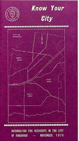
Pamphlet, Know Your City - Information for Residents in the City of Ringwood - November 1970, 1970
Maroon coloured 1970 community information brochure for Ringwood residents covering Councillors' contact details and local services, sporting, and cultural facilities. Includes two City of Ringwood Free Tipping Vouchers valid until the end of 1971.rinx -
 Ringwood and District Historical Society
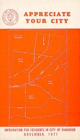
Pamphlet, Appreciate Your City - Information for Residents in the City of Ringwood - November 1971, 1971
Orange coloured community information brochure for Ringwood residents covering Councillors' contact details and local services, sporting, and cultural facilities. Includes two City of Ringwood Free Tipping Vouchers valid until the end of 1972, Council permit requirements, Nature strips and street trees, Vandalism, Road safety and Parking regulations.rinx