Showing 550 items matching "timber work"
-
 Kiewa Valley Historical Society
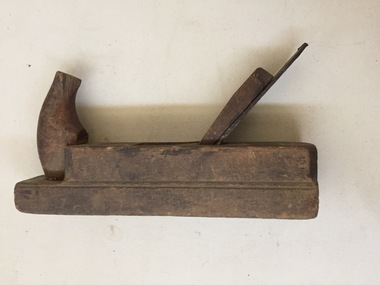
Woodworking Tool - Jack Plane
Very Old. Until the end of the 19th century the bodies of jack planes were predominantly wooden, typically made out of beech (wood). Wooden planes were largely superseded by iron-bodied planes.Used by carpenters and cabinet makers in the Kiewa Valley from the late 1800s and the early 1900s.A Jack Plane is a general purpose woodworking bench plane, used for dressing timber down to size in preparation for truing and/or edge jointing. It is usually the first plane used on rough stock, but for rougher work it can be preceded by the scrub plane. German Pattern Jack Plane. The smallest - 1.5 inches. Ref. Page 21 - Tools for all Trades Catalogue 1930s?"The Burgham Tools Company / Solingen Germany"woodworking tool, jack plane, plane -
 Kiewa Valley Historical Society
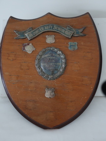
Shield - School Sports
Schools divided the children / students into houses for internal sports competition. The students' team and their participation was rewarded by acknowledgment on a shield or trophy.This trophy was for Mt Beauty Primary School sports during the 1950s and 1960s. It was sponsored by the Mt Beauty School Mothers' Club indicating that the parents supported the sports. During this time, the 1950s and 1960s Mothers' Clubs existed and supported the schools. Later they became Parents Clubs and later still struggled to exist at all as both parents went to work.Wooden shield with banner (silver plated) across the top. Central round silver plated medallion which is surrounded by 4 small medallions. Timber is stained with a darker stain around the edges. There are eyelets and wire for hanging attached to the back.The Banner: "Mount Beauty School 4644" Central Medallion: "Mothers' Club / Shield / for / House Competition / 1951" The small medallions: have house colour and year eg. "Blue / 1968"school sports, mount beauty school sports, mother clubs -
 Kiewa Valley Historical Society
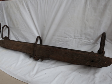
Plough Yoke - Swingletree
Bullock drays were commonly used to transport heavy loads, such as the wool clip from a large property, across long distances.In the 19th century. The yoke is worn on the neck of the bullocks and is secured by a belt around the neck. The bullocks push the yoke with their shoulders, hump and neck; therefore, the work is performed.This yoke seems to be handmade on a farm. It was used in the Kiewa ValleyA wooden bar behind a harnessed horse. It is used to balance the pull of a draught horse or other draft animal (bullock) when pulling a vehicle like a plough. A yoke is an interface between bullock power and actual work to be performed.This yoke is timber with a shape to form curved depressions that allow it to rest across the necks of two bullocks to keep them together.The bullocks were chained to the steel oblong ring - one at each end of the yoke. The middle ring was attached to the bullock or vehicle in front of them.bullock yoke, swingletree, farm equipment, plough -
 Kiewa Valley Historical Society
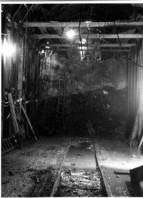
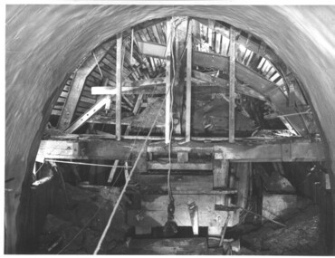
Photograph Tailrace tunnel Arch Drive, Tunnel face at Tailrace showing Arch Drive, between 1943 and 1952
This photo was taking during construction of the tailrace tunnel between West Kiewa Power Station and Mt. Beauty. Much of the area was unstable and timber supports were erected prior to concreting. The tunnel was commenced in 1941 and completed in 1952. It brings water from the power station into the open tailrace at Mt. Beauty and then into the regulating pondage before discharge into the Kiewa River.Shows method of construction for supporting walls and ceiling of tunnel with timber, size of tunnel (note worker on upper level), and conditions in the work place during construction in the 1940's/50's - note the timber ladder to gain access to the upper level.Black and white photographHand written on back of photograph "Tunnel face at Tailrace showing Arch Drive".tailrace, power station, water, construction -
 Kiewa Valley Historical Society
Photograph during construction of West Kiewa tunnel, 'Timbering in West Kiewa Tunnel', c1947
The West Kiewa Tunnel (tailrace tunnel) was commenced from both ends in 1947. Very difficult conditions were encountered in the driving of this tunnel and this meant the immediate provision of support and later the lining of the tunnel with concrete. Work proceeded steadily and the breakthrough of the two headings occurred on 22nd July, 1950.This historical photograph shows in detail the amount of work necessary to stabilise and support the tunnel walls before lining with concrete. No solid rock was found and the tunneling proceeded through decomposed boulders, gravel and clay, hence the necessity for support and concreting. Black and white photograph showing the timber support, prior to lining with concrete, in the West Kiewa tunnel.Timbering in West Kiewa Tunnelwest kiewa, tailrace, tunnel -
 Kiewa Valley Historical Society
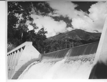
Photograph of Lake Guy Dam, Spillway, Lake Guy Dam, c1945
In December 1939 the excavation of the diversion tunnel at the site of Junction (Lake Guy) Dam was commenced and finished in February, 1940.This allowed the stream to be diverted to facilitate the dam wall construction. This is a 'slab and buttress' dam. It is framed with timber and concrete then poured into the structure. A contract was let to Lewis Construction Co. for the construction of the dam, and the first batch of concrete was placed in September, 1940. Industrial trouble caused some delays but there was also slow progress on the part of the contractor and the work was taken over by the S.E.C., terminating the contract. The dam was completed in March, 1944. The lake is named after Mr. L.T. Guy who was the Resident Engineer, in charge of construction work and associated activities on the Kiewa area, from 1939 until November 1946. An historical pictorial record taken for the State Electricity Commission of Junction Dam (Lake Guy) on spill. Mt. Arthur is in the background and there is still evidence of the destruction of trees from the 1939 bushfires. Black and white photograph of Lake Guy Dam . The dam is spilling and Mt. Arthur is in the background. Hand written on back of photograph in blue ink " Lake Guy Dam".dam, lake, water, mr. l.t.guy -
 Kiewa Valley Historical Society
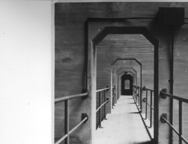
Photograph of Lake Guy Dam, Walkway, Inside Lake Guy Dam, c 1945
Lake Guy Dam is a 'slab and buttress' type wall. A timber frame is built and then filled with concrete. The first batch of concrete was placed in September, 1940. By June, 1941 the buttresses were finished to a height safe from floods and in October of that year a flood of 2,800 cusecs occurred but with only slight damage to the installations. Industrial trouble caused some delays but there was also slow progress on the part of the contractor and the work was taken over by the S.E.C., terminating the contract. The dam was completed in March, 1944. A walkway was made through the dam wall. Lake Guy was named after Mr. L.T. Guy who was the Resident engineer, in charge of construction work and associated activities on the Kiewa Area from 1939 to November 1946.Shows the walkway placed as part of the Lake Guy (Junction) Dam wall. A very good pictorial reference for the future.Black and white photograph of the walkway through Lake Guy (Junction) Dam wall.Handwritten in blue ink on back of photograph "Inside Lake Guy Dam". slab, buttress, dam, mr. l.t. guy -
 Eltham District Historical Society Inc
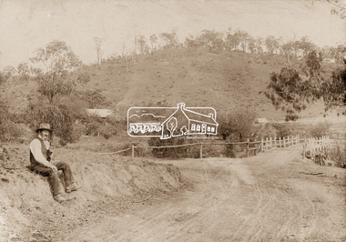
Photograph, Mr Belot smokes his pipe whilst resting at Cottle's Bridge, c.1890
The area, previously known as Back Creek, was named after Thomas Cottle, who settled in the district in the 1870s, and the original bridge over the Diamond Creek on the road to Strathewen. The original bridge (seen in the photo) was replaced with a new timber bridge at a cost of £1,500, the tender being awarded to a contractor named Birch who commenced work in June 1927. The gentleman in the photo who is resting whilst having a smoke of his pipe is a member of the Belot family.Original sepia photograph mounted on card broken lower left corner and cracked upper rightbelot, bridge, cottles bridge, cottles bridge-strathewan road, diamond creek (creek), heidelberg-kinglake road -
 Eltham District Historical Society Inc
Photograph, Fitting of Time Capsule, Eltham, 1987, 1987
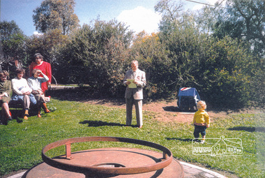
In November 1985 a monument was installed near the corner of Main Road and Pitt Street in Eltham, within the gardens at the front of what is now the Eltham Community and Reception Centre. This monument commemorates Victoria's 150th anniversary and the former location of the Eltham Town Centre, which existed along this section of Main Road, then known as Maria Street. Beneath the site is a time capsule to be opened in the year 2035. A plaque was also erected at this site in October 1987 to commemorate the Shire of Eltham Historical Society's 20th anniversary. The main feature of this monument is a ?tyring disc?, a blacksmith?s implement that was found on this site. This consists of a large iron disc that was used as a platform for fitting iron tyres (like the one shown on top of the platform) to wooden spoked cart wheels. The local blacksmith and wheelwright worked together to assemble the wheel, which was clamped to the platform placed close to the fire. The red hot iron hoop, previously forged to the correct size was lifted with tongs by the blacksmith over the outside of the rim, then hammered down amid flames from the scorching timber. The wheelwright drenched the tyre with cold water as soon as it was in position. A clamp placed on the naff (hub) and screwed down tightly kept the spokes at a constant angle as the tyre cooled. An even pressure from the contracting tyre tightened the joints at each end of the spokes and formed a vice-like grip, which would last for the life of the wheel.Four colour photographs (laser printed on paper); two showing the fitting of the time capsule into the monument and two showing Joh Ebeli during the dedication presentation.eltham, joh ebeli, time capsule -
 Warrnambool and District Historical Society Inc.
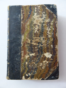
Book, The Practical Measurer, 1863
This book, ‘The Practical Measurer’, by Alexander Peddie, is subtitled ‘Tradesman and Wood Merchant’s Assistant’. It is a tradesman’s guide to measuring and contains many tables of measurement. The inscription in the front of the book shows that it belonged to Thomas Osborne and that he obtained it from D. McColl who is identified in the inscription as the Chief Engineer of the steam ship, ‘Julia Percy’. There is a record of a Donald McColl owning the vessel ‘Mimmie Dyke’ and sailing it to Mauritius in 1856 and there is also a record of the death of a Donald McColl in 1880 so these two facts may refer to the D.McColl mentioned by Thomas Osborne (especially as he refers to him as ‘poor old Mr D. McColl’). Thomas Hamilton Osborne was born in Port Fairy in 1851. He had a lifelong interest in ships and in Warrnambool was the Secretary and then Manager of the Western Steam Navigation Company for 16 years. Osborne wrote many articles with nautical themes using the nom-de-plume of ‘Sliding Gunter’ and had a great love of, and interest in, the ship, ‘Julia Percy’ and when he died in 1902 his body was put on board the ‘Julia Percy’ and he was buried at sea. The ‘Julia Percy’ (built 1876) was a well-known steamship on the western Victorian coast for many years. Later it plied the Queensland coast, saw service in West Australian waters, was renamed the ‘Leeuin’ and was used as a coal hulk until it was scuttled in 1935. The signature in the book of T. Hyland may indicate that he donated the book to the Warrnambool and District Historical Society. This book is of prime importance because:- 1. As a book printed in 1863 it is of antiquarian interest. 2. The connection with Thomas Osborne is of key interest as he was a notable figure in Warrnambool’s 19th century history, especially in maritime circles. 3. The connection with the ship, ‘Julia Percy’, is of particular interest as it was a prominent ship in Warrnambool’s maritime history. This is a hard cover book of 448 pages with brown and gold leather binding on the spine and cover edges and a brown and tan mottled pattern cover. The book has a Preface, a Contents page, information on how to measure all types of solid figures and how to measure work involved in the various trades – masons, carpenters, painters, glaziers, plumbers etc. It also has two Appendices with information on the measurement of sawn timber. The text has many tables and diagrams. The first page has a handwritten inscription in black ink and the back pages have some mathematical calculations written in pencil and a mathematical problem with its solution written in ink. Handwritten: ‘T. P. Hyland’ Stamped: ‘T.H.Osborne’ Typed label: ‘Mr T. H. Osborne, Warrnambool’ Handwritten: ‘T.H. Osborne, Warrnamool, Australia, given to me by poor old Mr D. McColl, Chf. Engineer, Julia Percy S.S., 1888’ thomas osborne, history of warrnambool, maritime history of victoria, ‘julia percy’ steamship -
 Warrnambool and District Historical Society Inc.
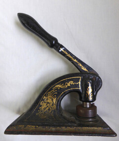
Functional object - Newcombe timber company Seal, Mid to Late 19th century
Newcombe and Co traded as timber merchants And iron mongers in Koroit Street in the later part of the 19th century and early 20th century. It was destroyed by fire in March 1918.A commonly used office item which is well linked to a long established business in Warrnambool.Cast iron rectangular base with arch form leading to handle. Painted black and decorated with gold scroll work. Orange line around rectangular base. The seal is operated by pushing down the handle which stamps on paper which would be placed between the circular stamp and the base plate.warrnambool, company seal, embossing seal, newcombe timber company, koroit street -
 Eltham District Historical Society Inc
Negative - Photograph, Warrandyte Bridge over River Yarra, c.1910
View of the 1875 timber trestle bridge over the Yarra River reproduced from a newsprint image. Also known as Anderson's Creek (Road) Bridge A contract was accepted for William Elliot to erect a bridge over the Yarra River at Warrandyte on Anderson's Creek Road and other improvements for £1,331.6.2 - Gazette No. 143. Tuesday, November 13th 1860 - http://gazette.slv.vic.gov.au/view.cgi?year=1860&class=general&page_num=2161&state=V&classNum=G143&id=). The bridge was washed away by floods in 1863. It was replaced with a taller timber trestle structure in October 1875, designed and built by C.S. Wingrove, Shire Clerk, Engineer and Surveyor for Eltham Shire Council. A replacement for this bridge was commenced in 1955 to cope with increasing traffic and this structure was widened in 2018 to meet further traffic demands. Argus (Melbourne, Vic. : 1848 - 1957), Thursday 23 September 1875, page 7 ________________________________________ THE WARRANDYTE BRIDGE. The ceremony of formally opening the newly erected bridge over the Yarra at Ander-son's Creek was performed on Monday last, in the presence of the members of the Eltham and Bulleen shire councils whose territories it joins, and a goodly number of the residents of the district. The task was delegated to Mr. Cameron, M.L.A., who, after a few introductory remarks declared the bridge to be opened, and christened it the " Warrandyte Bridge." The party then adjourned to Grant's Hotel, where a cold collation had been prepared. The chair was taken by the president of the Eltham shire (Mr. John Bell) and the vice chair by Mr. Kent, a member of the Bulleen council. Mr Robert Williamson proposed "Success to the bridge," coupling with it the name of Mr. Cameron, to whose exertions was in the main to be attributed the erection of that structure which was an ornament to the district and would prove of great service to both sides of the river. Mr. Cameron, in responding, alluded to the great difficulties, mainly of a pecuniary nature, that had been encountered in carrying out the project, and which had only been got over by their united efforts and by the liberal spirit in which the late Commissioner of Roads had dealt with the case. The healths of the contractor and the engineer were also drunk. The bridge is a trussed timber one, resting on yellow box piles sunk into the solid rock, each pier being weighted with 50 tons of stone. The abutments consist of dry stone walls, 6ft. thick at the base, and tapering to 3ft. on the top, the face of the work having a batter of 1 to 1. The length of the bridge is 308ft., there being four openings in the centre of 66ft. each, and two at the ends of 20ft. each. The width in the clear is 9½ft., and the height from the bed of the river about 33ft. The approaches comprise 1,100 cubic yards of earthwork, and the formation of 48 chains of sideling, the whole cost of the work, which was carried out under the direction of the engineer to the Eltham Shire Council, being £1,413.This photo forms part of a collection of photographs gathered by the Shire of Eltham for their centenary project book,"Pioneers and Painters: 100 years of the Shire of Eltham" by Alan Marshall (1971). The collection of over 500 images is held in partnership between Eltham District Historical Society and Yarra Plenty Regional Library (Eltham Library) and is now formally known as the 'The Shire of Eltham Pioneers Photograph Collection.' It is significant in being the first community sourced collection representing the places and people of the Shire's first one hundred years.Digital image 4 x 5 inch B&W Neg B&W Print 12.5 x 9 cmsepp, shire of eltham pioneers photograph collection, warrandyte, bridge -
 Eltham District Historical Society Inc
Photograph, Henley Bridge, Spring Excursion, Exploring the Upper Yarra, 22 October 1995, 22/10/1995
[article by Bettina Woodburn in EDHS Newsletter No. 105, November 1995:] EXPLORING THE UPPER YARRA - We enjoyed the Spring Excursion, this year "Exploring the Upper Yarra" - in spite of the constant rain and the countryside under the cloud cover, especially in the valleys, being mainly shiny shades of green. The occasional fields of buttercups, clumps of arum lilies and splendid rhododendron and other flowering bushes became very special. The Cobb and Co coach was warm and a cosy retreat as we zig-zagged on the highways and byways to glimpse the Yarra River, upstream and down, its secret places, and particularly the many bridges. Russell excelled as 'Poet Laureate', reading from Dacre Smyth's book. This 1979 publication includes paintings of all the bridges along the river with poems and brief descriptions of each one. Some of the bridges are in out-of-the-way places and are not very well known. We looked forward to hearing the poetry as much as seeing the 'constructions'… Big Pat (was he short or tall, lean or fat? - he did win the £200 reward for discovering gold and had the creek named after him), about the 'Eddies'?, and the disliked 'meccano' bridge in Warburton, etc. etc. The hot roast lunch in the old Reefton Hotel was also most welcome. It was easy to imagine it peopled by miners and early settlers. Starting by crossing the new (1974) concrete bridge at Warrandyte we headed through Wonga Park with views to the Christmas Hills and to the escarpment of the Yering Gorge, which causes flood waters to back up through the Yarra Glen plain, so avoiding disasters downstream. At the end of a long driveway we found the wooden, privately owned Henley Bridge (1935 after the 1934 floods). This facilitates access to different parts of Henley Farm and to Lilydale. Everard Park, named after Blanche Shallard's father, a State Member for 17 years, below the Highway Yarra crossing was in need of care. It is 10 miles from Yarra Glen by road but, as "Yarra Marra” canoeists well know, 32 winding miles down by water. After more delightful countryside scenes we joined the Warburton Highway at Woori Yallock. From the old Railway Station at Launching Place the Centennial Trail for walkers, cyclists and horse riders has replaced the rails. The line from Lilydale was opened in 1901, and the last diesel freight train ran to Warburton in 1965. It continued to rain as we had morning tea in Warburton in a shelter between footbridges. From here we continued upstream past the Bridge to O'Shannassy Lodge and Reservoir, Starvation Creek, and the Peninsular tunnel (miners dug it as at Pound Bend) which we visited (scrambling down those steps!) on our return after lunch. Our furthermost point was the Upper Yarra Dam Reserve (and vast catchment area). Finished in 1957 after ten years' work and 100 years after Yan Yean, it supplies much of Melbourne's water. After crossing the 30m Launching Place Bridge to the Eltham side of the Yarra and Healesville, we saw in the distance the Yarra Glen Timber Trestle Bridge over the river flats "the longest for years in the land it was said!" Harry's dream of "better weather over the Divide" unfortunately didn't come true, but I'm sure we 36 members will retain happy memories of a day that was wet and green and filled with Bridges. Situated on the Yarra River, 5.5 kms south of Christmas Hills on private property. This timber trestle bridge is said to have been built some time after 1907 by Melbourne master-builder, David Mitchell (the father of Dame Nellie Melba), to connect his two "Henley Farm" properties with Lilydale. In earlier days, when the McPhersons owned the property, their children used a punt to cross the river to attend Yering Primary School. This private bridge is best viewed from the end of Wendy Way. - Source: Christmas Hills Past and Present, Yarra Glen & District Historical Society, 2004.Two colour photographsactivities, henley bridge, upper yarra -
 Eltham District Historical Society Inc
Photograph, Spring Excursion, Exploring the Upper Yarra, 22 October 1995, 22/10/1995
[article by Bettina Woodburn in EDHS Newsletter No. 105, November 1995:] EXPLORING THE UPPER YARRA - We enjoyed the Spring Excursion, this year "Exploring the Upper Yarra" - in spite of the constant rain and the countryside under the cloud cover, especially in the valleys, being mainly shiny shades of green. The occasional fields of buttercups, clumps of arum lilies and splendid rhododendron and other flowering bushes became very special. The Cobb and Co coach was warm and a cosy retreat as we zig-zagged on the highways and byways to glimpse the Yarra River, upstream and down, its secret places, and particularly the many bridges. Russell excelled as 'Poet Laureate', reading from Dacre Smyth's book. This 1979 publication includes paintings of all the bridges along the river with poems and brief descriptions of each one. Some of the bridges are in out-of-the-way places and are not very well known. We looked forward to hearing the poetry as much as seeing the 'constructions'… Big Pat (was he short or tall, lean or fat? - he did win the £200 reward for discovering gold and had the creek named after him), about the 'Eddies'?, and the disliked 'meccano' bridge in Warburton, etc. etc. The hot roast lunch in the old Reefton Hotel was also most welcome. It was easy to imagine it peopled by miners and early settlers. Starting by crossing the new (1974) concrete bridge at Warrandyte we headed through Wonga Park with views to the Christmas Hills and to the escarpment of the Yering Gorge, which causes flood waters to back up through the Yarra Glen plain, so avoiding disasters downstream. At the end of a long driveway we found the wooden, privately owned Henley Bridge (1935 after the 1934 floods). This facilitates access to different parts of Henley Farm and to Lilydale. Everard Park, named after Blanche Shallard's father, a State Member for 17 years, below the Highway Yarra crossing was in need of care. It is 10 miles from Yarra Glen by road but, as "Yarra Marra” canoeists well know, 32 winding miles down by water. After more delightful countryside scenes we joined the Warburton Highway at Woori Yallock. From the old Railway Station at Launching Place the Centennial Trail for walkers, cyclists and horse riders has replaced the rails. The line from Lilydale was opened in 1901, and the last diesel freight train ran to Warburton in 1965. It continued to rain as we had morning tea in Warburton in a shelter between footbridges. From here we continued upstream past the Bridge to O'Shannassy Lodge and Reservoir, Starvation Creek, and the Peninsular tunnel (miners dug it as at Pound Bend) which we visited (scrambling down those steps!) on our return after lunch. Our furthermost point was the Upper Yarra Dam Reserve (and vast catchment area). Finished in 1957 after ten years' work and 100 years after Yan Yean, it supplies much of Melbourne's water. After crossing the 30m Launching Place Bridge to the Eltham side of the Yarra and Healesville, we saw in the distance the Yarra Glen Timber Trestle Bridge over the river flats "the longest for years in the land it was said!" Harry's dream of "better weather over the Divide" unfortunately didn't come true, but I'm sure we 36 members will retain happy memories of a day that was wet and green and filled with Bridges.Two colour photographsactivities, upper yarra, upper yarra dam -
 Eltham District Historical Society Inc
Photograph, Yarra River from Henley Bridge, Kangaroo Ground, Spring Excursion, Exploring the Upper Yarra, 22 October 1995, 22/10/1995
[article by Bettina Woodburn in EDHS Newsletter No. 105, November 1995:] EXPLORING THE UPPER YARRA - We enjoyed the Spring Excursion, this year "Exploring the Upper Yarra" - in spite of the constant rain and the countryside under the cloud cover, especially in the valleys, being mainly shiny shades of green. The occasional fields of buttercups, clumps of arum lilies and splendid rhododendron and other flowering bushes became very special. The Cobb and Co coach was warm and a cosy retreat as we zig-zagged on the highways and byways to glimpse the Yarra River, upstream and down, its secret places, and particularly the many bridges. Russell excelled as 'Poet Laureate', reading from Dacre Smyth's book. This 1979 publication includes paintings of all the bridges along the river with poems and brief descriptions of each one. Some of the bridges are in out-of-the-way places and are not very well known. We looked forward to hearing the poetry as much as seeing the 'constructions'… Big Pat (was he short or tall, lean or fat? - he did win the £200 reward for discovering gold and had the creek named after him), about the 'Eddies'?, and the disliked 'meccano' bridge in Warburton, etc. etc. The hot roast lunch in the old Reefton Hotel was also most welcome. It was easy to imagine it peopled by miners and early settlers. Starting by crossing the new (1974) concrete bridge at Warrandyte we headed through Wonga Park with views to the Christmas Hills and to the escarpment of the Yering Gorge, which causes flood waters to back up through the Yarra Glen plain, so avoiding disasters downstream. At the end of a long driveway we found the wooden, privately owned Henley Bridge (1935 after the 1934 floods). This facilitates access to different parts of Henley Farm and to Lilydale. Everard Park, named after Blanche Shallard's father, a State Member for 17 years, below the Highway Yarra crossing was in need of care. It is 10 miles from Yarra Glen by road but, as "Yarra Marra” canoeists well know, 32 winding miles down by water. After more delightful countryside scenes we joined the Warburton Highway at Woori Yallock. From the old Railway Station at Launching Place the Centennial Trail for walkers, cyclists and horse riders has replaced the rails. The line from Lilydale was opened in 1901, and the last diesel freight train ran to Warburton in 1965. It continued to rain as we had morning tea in Warburton in a shelter between footbridges. From here we continued upstream past the Bridge to O'Shannassy Lodge and Reservoir, Starvation Creek, and the Peninsular tunnel (miners dug it as at Pound Bend) which we visited (scrambling down those steps!) on our return after lunch. Our furthermost point was the Upper Yarra Dam Reserve (and vast catchment area). Finished in 1957 after ten years' work and 100 years after Yan Yean, it supplies much of Melbourne's water. After crossing the 30m Launching Place Bridge to the Eltham side of the Yarra and Healesville, we saw in the distance the Yarra Glen Timber Trestle Bridge over the river flats "the longest for years in the land it was said!" Harry's dream of "better weather over the Divide" unfortunately didn't come true, but I'm sure we 36 members will retain happy memories of a day that was wet and green and filled with Bridges.Colour photographactivities, upper yarra, henley bridge -
 Orbost & District Historical Society
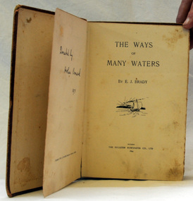
book, The Ways of Many Waters, 1899
This book of poetry by E. J. Brady was originally published by the Bulletin Newspaper Company (Sydney) in 1899,Later it was reprinted by Thomas C. Lothian (Melbourne) in 1909, and by the Standard Publishing Company (Melbourne) in 1913.] E. J. Brady was an Australian poet. He was born at Carcoar, New South Wales, and was educated both in the United States and Sydney. He worked as a wharf clerk, a farmer, and journalist, and edited both rural and city newspapers This book is culturally important as Edwin James Brady represented the Bulletin school of the 1890s. The Bulletin was very popular with rural bush workers and selectors and became known as ‘the bushman’s bible’. It encouraged contributions of poetry, short stories and cartoons from its readerswho included miners, shearers and timber-workers from all over Australia. Some of this content was high quality and many of Australia’s important writers had their start with The Bulletin which became know as the ‘Bulletin School’ of literature.A small 155 pp fabric covered brown book with a very faded picture of a boat sailing toward a sunset on the front cover.poetry literature brady-edwin-james the-ways-of-the-waters -
 Orbost & District Historical Society
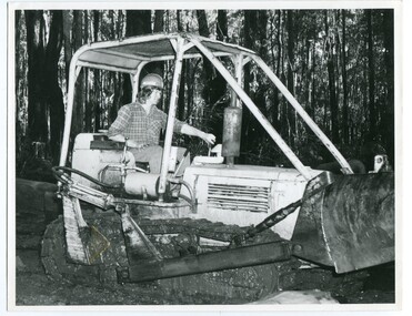
black and white photograph, VR Printing Works, 1975
This photograph, one of set of six, shows Ken Donchi, the youngest family member (at the time of photograph) at work as a sleeper cutter in the Orbost area since the 1890s. The photograph was used in an article for the Victorian Railways Magazine 1975. . It contains photographs and an article about Orbost as "Timber Country" and a detailed article titled, " Cutting Sleepers is a Family Business" which tells about the Donchi family.This item is associated with the timber and sleeper-cutting industry in the Orbost Region. Timber sleepers were superceded by concrete sleepers in c. 1970s. Orbost has historically been based on the timber industry, but that industry has declined considerably over the last 20 years. .The number of locals involved in the timber industry has declined and many of the mills have closed. This item reflects a time when that industry was a significant contributor to the economy of the district.A black / white photograph of Ken Donchi driving a bulldozer in bushland outside of Orbost.on back - Pr 8769donchi-pat sleeper-cutting timber-industry-orbost-railway -
 Orbost & District Historical Society
black and white photograph, VR Printing Works, 1975
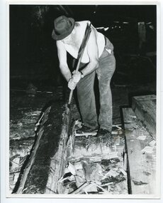
This is one of a set of six photographs taken for the Victorian Railways Magazine, a pamphlet produced for Victorian Railways. t contains photographs and an article about Orbost as "Timber Country" and a detailed article titled, " Cutting Sleepers is a Family Business" which tells about the Donchi family The man in the photograph is Pat Donchi, a member of the Donchi family, who have been involved in the sleeper - cutting industry since the 1890s. This item is associated with the timber and sleeper-cutting industry in the Orbost Region. Timber sleepers were superceded by concrete sleepers in c. 1970s. Orbost has historically been based on the timber industry, but that industry has declined considerably over the last 20 years.The number of locals involved in the timber industry has declined and many of the mills have closed. This item reflects a time when that industry was a significant contributor to the economy of the district.A black / white photograph of a sleeper cutter at work swinging a broad axe.on back - Pr 8765timber-industry-orbost sleeper-cutting-orbost donchi-family -
 Ringwood and District Historical Society
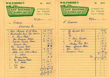
Document - Manila Folder, Collection of personal documents for Mr Emil Goddard, 15 Eastfield Road, Ringwood East, Victoria, 1947-1953
Correspondence between Mr Goddard and Repatriation Department regarding War Pension entitlements. Specifications of work to be done and materials to be used in the erection of a timber residence at 15 Eastfield Road, Ringwood East, for E.K. Goddard. Contract of Sale of Land at Lots 55 & 56 on P/S No.10492, part of Crown allotments 27 and 28,B, Parish of Ringwood, County of Mornington. Miscellaneous receipts from 1947-1953 including Hire Purchase Agreement for Hillman Minx car. Also includes letter from Presbyterian Ladies' College referring to 1953 term 1 fee of £18.0.3 for Margaret Goddard Receipts from Wiltshire's East Ringwood Hardware, 98 Railway Avenue, East Ringwood, Phone 87-6092, 8/7/1962. -
 Orbost & District Historical Society
black and white photograph, early 20th century
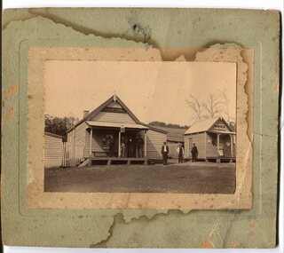
The hotel at Bonang was also known as Clancy's Hotel, Bonang, after its licensee, William Clancy. It operated from the late 1890s until early 20th century. William Clancy was aslo the postmaster at Bonang. A post office operated at Bonang from at least 1859. At the time Bonang was "a small, scattered collection of buildings marking the intersection of the Bonang Highway and the McKillops Bridge Road" ( from Regional Heritage Assessment 1996). As the mining activity declined the township became even smaller as many of the population moved to Orbost,, a larger settlement. This is a pictorial record of Bonang, a small settlement approximately 50 km north of Orbost. The buildings in the photograph no longer exist.A black / white photograph mounted on grey card. there are stains from water damage on the mount. It is a photograph of two single-storeyed timber buildings fronting a wide dirt road. On the right is the Bonang Hotel with four men in suits standing on a verandah. The building on the right is the Bonang Post Office and there are three men outside it. the photograph has been posed. on back - 'Grandma Clancy owned the hotel & Uncle Will had a gold mine which he worked"bonang bonang-post-office bonang-hotel clancy-william clancy's-hotel-bonang -
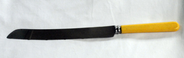 Orbost & District Historical Society
bread knife
... timber mills worked full time supporting the families that were ...This knife was used by Lottie Rem who ran the cookhouse at Astergren;s Timber Mill at Cabbage Tree in East Gippsland from 1954 until 1966.. It was bought in Orbost around 1957 - 1958. Sited on the banks of the Cabbage Tree Creek, the township was built by the timber mills to house their workers. Although the timber mills have disappeared, some of the buildings still remain. The "Cook House" and "Manager's House" are two buildings. The Cook House was built to supply meals to the workers of the Alstergren Mill. Some of the original interior walls were made from hessian and wallpaper. The few houses to survive to today are now used as private dwellings.The Cabbage Tree Creek township was established to support the booming timber industry of the mid 20th century. Five timber mills worked full time supporting the families that were drawn to the area's wealth of natural resources. this item is associated with the history of Cabbage Tree.A stainless steel serrated edged knife with a cream coloured handle (bone?)on blade -""Made in Sheffield expressly for Orbost Hardware and Timber Co, Orbost"alstergren-timber-cabbage-tree rem-lottie cook-house-alstergren's-timber-mill bread-knife-orbost-hardware -
 Orbost & District Historical Society
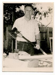
black and white photographs, 3281.1 : September 1987
3281.1 is a photograph of Terry Martin. "Terry Martin travelled to Melbourne to Melbourne to display his extensive collection of axes and to demonstrate the art of broadaxe cutting. The axe Terry is holding is over 200 years old and is believed to have been used by ship builders in their trade. Terry makes his own axe handles from district timber." (Snowy River Mail 23 September 1987) 3281.2 is of Erasmo Giove. who came to Australia with his wife, Mina. They eventually settled in Orbost where Erasmo worked as a sleeper cutter withn his wife working alongside him. The Gioves lived with their four children, Tina, Rocco, Benodino and Graziela, in Forest Road, Orbost,These photographs are associated with the timber and sleeper-cutting industry in the Orbost Region. Timber sleepers were superceded by concrete sleepers in c. 1970s. Orbost has historically been based on the timber industry, but that industry has declined considerably over the last 20 years..The number of locals involved in the timber industry has declined and many of the mills have closed. This item reflects a time when that industry was a significant contributor to the economy of the district.3281.1 is of a man standing holding a long handled axe. 3281.2 is of a man holding a cross cut saw and holding in the other hand a framed photograph of a swing saw.woodcutting-tools axe saw-cross-cut saw-swing timber-orbost sleeper-cutting giove-erasmo martin-terry -
 Ringwood and District Historical Society
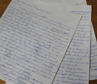
Letter, Letter written by H.C.Howship to Ringwood Mail Ringwood 1963
To the Editor of the Ringwood Mail Dear Sir, would you please publish in your widely read paper the following letter for the information of the residents of the City of Ringwood- Re the passing of my brother Mr. J.P. Howship, who was an ANZAC one of the pioneer family of Howship of Ringwood which name is connected with the early history of Ringwood or more particularly Ringwood East as the late J.P. Howship and myself purchased the Nursery of Mr. John Hill around the year 1912 and after a couple of years my late brother Bert was taken into partnership and we bought the adjoining nursery of Mr. Will Hill and traded under name Howship Bros. Rosedale Nursery and the name of one street in the old property Howship Avenue is named after the old firm as well as Rosedale Crescent. The move for the establishment of the Ringwood East station started with myself and in a meeting up with a Mr .T. Birkitt who I felt was the man I needed as he was a sub Estate Agent .A meeting was called and held in our packing shed at the end of Federal Road which at that time ended at Mr. Charlie Burdens property and abbuted (sic) on our property. This meeting was attended by about sixty residents and the late Mr. C. Wedge was elected as the first President of the Ringwood East Railway League and Progress Assoc. with Mr. T. Birkitt as Secretary and myself as assist. Secretary. This League raised the sum of about 1,600 from residents and land owners for the erection of the Ringwood East Railway Station & after the station was erected and paid for the League part was canceled and the Progress Assoc. carried on. The present Ringwood East Cricket Club was formed at meeting and the Prog .......and my three brothers Bert, Mervyn and played cricket in the Ringwood district for many years and most of us were members of the Ringwood at first and then the Ringwood East Football clubs and followed the teams for years a few names of the old players came to mind in E. Thomas , C. Weil, T. Homewood, the Pratt family and others. I might mention for the benefit of the City of Ringwood residents my eldest brother Laurie late of New Street and now living at Blairgowrie was with what was then known as Coopers Mills and designed and helped to build some of the first buildings in that property now known as Ringwood Timber & Trading Co .Also that myself and others namely the Reidy Brothers, Mr. Taylor, & L .Cleary & voluntary labour formed the tennis courts at East Ringwood with the help of our young Ladies of the time, those courts I'm pleased to say are well established and two more are added and provide good activities for the young people of the district. Also with the aid of C .Thomas, Norm Blood and others we formed the Methodist courts. From the Ringwood East Progress Association came the move to have a Health Centre for Ringwood. This was established by a good deal of enthusiastic work by some mothers after spending nearly fifty years in Ringwood watching it grow from town surrounded by orchards to a City and I must congratulate the Civic Fathers and their staff in the growth of Ringwood and the fine roads, Parks, Elderly Citizens Club and have all done a good job but why oh why have you neglected mines Road Ringwood east. Why has this road not been made the drainage there is something to be seen to be believed in such a city .The only solution is making and curbing this road & I would ask those responsible why the curbing was put down Dublin Road where there are no residents this curbing could well have solved the problem in Mines Road if used there. I recently spent a weekend with my Daughter, Mrs. Munro at the corner of Maroondah highway and Mines Road and was disgusted at the condition of Mines Road and drainage and had to air my views and suggest a trip to Mines Road by the Civic Fathers led by the Health Inspector I am yours sincerely H.C. Howship Sheila Street, Rye. (copied here verbatim)3 pages of hand written letter detailing the early history of the East Ringwood Railway and Progress Association, football, cricket and tennis clubs.. Written as a draft in 1963. -
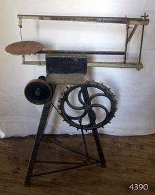
 Orbost & District Historical Society
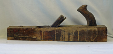
trying plane, first half 20th century
A heavy trying plane would have been used in construction work on rural properties. It can be used for planing hard, difficult timbers.Tools such as this would have been used in the construction of local homes, or rural outbuildings in early Orbost.. It is representative of an era before power tools. A long, heavy wooden plane used in smoothing the edges of roughly planed wood.woodwork tools plane-trying -
 Ringwood and District Historical Society
Photographs, 1979-80 MMBW pipe line project at Hubbard Reserve, North Ringwood � View towards Debbie Place
Part of a 43-photo record of the MMBW�s engineering feat in drilling a 12 inch pipe line up to 40 feet deep through rock hardened by volcanic action associated with geological fault that occurs along the line. The work took place from October 1979 to May 1980 on the southern boundary of Hubbard Reserve, North Ringwood. The collection was presented to the Ringwood Historical Research Group by J Clarke on 9th June 1980.E561 N15 3 March 1980 A43 View towards Debbie Place, showing 2 swivel cranes at shafts, timber of manhole in creek, the tracked drill rig and its compressor caravan. -
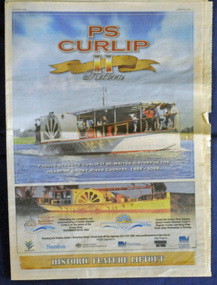 Orbost & District Historical Society
newspaper, PS Curlip, November 2008
This inset was published to commemorate the Curlip Festival on 28/30 November 2008 and the P.S. Curlip 11 launch. The Snowy River Mail is an East Gippsland Newspaper. The original PS Curlip was a paddle steamer built in a Tabbara sawmill in 1889 by Samuel Richardson and his sons. It was operated along the Snowy River in Australia's Gippsland region between 1890 and 1919, before being washed out to sea, and broken on Marlo beach, by a flash flood. The Orbost and district community started a project in 2002 to construct a live steam powered replica, albeit somewhat larger than the original to meet safety regulations and carry additional passengers for commercial reasons, the Paddle Steamer Curlip II with the assistance of grants from the Federal and Victorian State Governments.Construction was started in earnest by shipwright, Bill Jones, in August 2006, and with the assistance of roughly 200 volunteers (a core group of 10 performing the majority of the work), she was finally completed and launched on the Snowy River in late November 2008. The construction of P.S.Curlip 11 was a community project which began as a project to re-engage the timber-working community of Orbost. The construction and launch was a major community event. The local newspaper, The Snowy River Mail, documented its progress on a regular basis.An insert from the Snowy River Mail newspaper dated November 2008. On the front cover is a coloured photograph of the Paddle Steamer Curlip 11. It contains photographs, information on the history of P.S. Curlip and the construction of Curlip 11. There are details of the Curlip Festival and advertisements.newspaper p.s.curlip -
 Orbost & District Historical Society
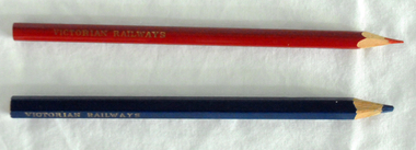
pencils, 1960's
These pencils were supplied to the Orbost railway Station office to be used for clerical work. They were used by Victor Smithers who was the Assistant Station Master at Orbost from 1957 - late 1960's. He was also a reliever until the 1970's after which he returned to Ormond Station on the Frankston line where he worked until his death in 1979. The Bairnsdale-Orbost railway was opened in 1916 to serve the agricultural and timber industry. Because of the decline in traffic and heavy operating costs, the line was finally closed in August, 1987. Orbost Railway Station was opened on Monday 10 April 1916 as the terminus of the Orbost railway line, and closed in 1987. The station was located on the west side of the Snowy River despite the town of Orbost being on the east side of the river, in order to save on the costs of a bridge over the river, which at the time had highly variable levels. This item is associated with the history of the Orbost-Bairnsdale railway line and therefore reflects the role that the rail line played in the social and economic history of Orbost.Two coloured pencils. 2580.1 is a hexagonal blue pencil and has "Wolff's Emperor MADE IN AUSTRALIA". 2580.2 is a round red pencil with "Wolff's Fintorex MADE IN AUSTRALIA coloured copying". Both have "VICTORIAN RAILWAYS" marked in gold lettering on the sides. orbost-railway-station smithers-victor -
 Orbost & District Historical Society
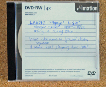
D.V.D, Laurie Popeye Light, 1950-1992
The video shows Laurie LIght, a sleeper cutter for 42 years, using a swing saw. There is also a video of a lyre bird display. Laurie Light was born on May 12, 1938 to parents, Arthur Vernon Light and Nellie Hall. He started work with his father, a sleeper cutter for the Victorian Railways, at the age of 16. (More info. from newsletter LAURIE LIGHT, SLEEPER CUTTER - Heather Terrell)This item is associated with the history of the Orbost-Bairnsdale railway line and therefore reflects the role that the rail line played in the social and economic history of Orbost. It is also associated with the timber industry of East Gippsland.A D.V.D. of pictures and a video on Laurie Light, a sleeper cutter from 1950-1992. The disc is in a clear plastic case with a black insert. It is a copy of the original. this copy was probably made in 2016.On disc in red marker : "LAURIE LIGHT SLEEPER CUTTING with swing saw and lyre bird display"sleeper-cutting light-laurie timber-industry-orbost -
 Flagstaff Hill Maritime Museum and Village
Tool - Treadle Scroll Saw, Hobbies Ltd, Manufactured by Hobbies in England from 1928- 1965
Since 1895, Hobbies Ltd have been supplying model makers and enthusiasts throughout the world with a wide range of quality model kits, accessories, tools, components and handbooks. The Hobbies Company began life in Dereham, Norfolk in 1881 with a London Office opened later (1922) at 65 New Oxford Street, WC1. In 1895 Hobbies began supplying model makers with their products and in 1897 were incorporated into a Public company. In 1922 at a British Industries Fair the company had a stand advertising their products as "The All-British Firm with a World reputation". Fretwork Outfits. Fretwork Machines. Carpentry Outfits. Strip work Outfits. Also manufactures of Fretwork Tools and Benches, Wood, Circular Saws, Lathes, Picture Framing Outfits, Tools, etc. In 1947 the company had expanded and was still making tools and materials for the amateur craftsman in wood. They had acquired a reputation as manufacturers of quality Fretwork Outfits, Tools, Treadle Machines, Model Maker's Tool Kits. The company also publishers of ‘Hobbies Weekly magazine’ and also sold plans for fretwork, model making and wooden toys. In 1961 they were still manufacturers and retailers of craft tools and materials, timber merchants, light engineers and Government contractors with around 500 employees. A vintage tool made for hobbyists and distributed throughout the world by a British company that is still in existence today. The item is significant as it catalogues the manufactures history at a specific time in the company's development.Foot operated treadle Fret saw called "GEM" subject item is a short saw , the stand in the background is the base for a Delta Q3 model scroll saw. Gem inscription cast into the cast iron frameworkflagstaff hill, warrnambool, flagstaff hill maritime museum, maritime museum, shipwreck coast, flagstaff hill maritime village, great ocean road, saw, treadle saw, fret saw, pedal saw, the gem, tool, hobbies ltd, treadle, foot operated -
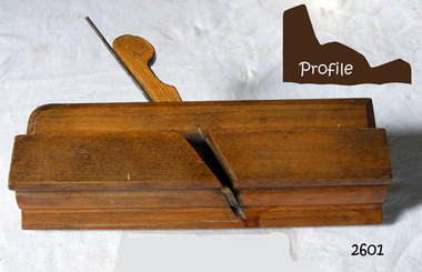 Flagstaff Hill Maritime Museum and Village
Tool - Complex Moulding Plane, Late 19th to early 20th Century
A smoothing or wood plane is a wood plane used for making a smooth or decorative moulding to the surface of wood. Traditionally these planes were made from blocks of wear resistant hardwood, often beech or maple, which were worked to the shape or size required. The blade, or iron was likewise formed to the intended flat or ornamental profile and secured in the body of the plane with a wooden wedge. A traditional cabinetmakers shop might have many, perhaps hundreds, of moulding and smoothing planes for the full range of work to be performed. Large crown Mouldings or smoothing plane surfaces required planes of six or more inches in width, which demanded great strength to push and often had additional peg handles on the sides, allowing the craftsman's apprentice or other worker to pull the plane ahead of the master who guided it. This plane is a coffin pattern smoothing plane and is unmarked so the maker is unknown however it's design and patina indicate it was probably made in the mid to late 19th century and would be regarded as a vintage or antique item sought after today by collectors of vintage tools. A vintage tool made by an unknown maker, that was made commercially for firms and individuals who worked in wood and needed a tool that could produce a flat or level finish to timber. These types of planes came in various shapes and sizes to achieve the required finish to timber surfaces used in cabinet making. This item is a significant tool from the mid to late 19th century that today is quite rare and sought after by collectors. It gives us a snapshot of how furniture and other decorative finishes were created on timber by the use of hand tools only. Complex moulding wood planeNoneflagstaff hill, warrnambool, plane, flagstaff hill, warrnambool, flagstaff hill maritime museum, maritime museum, shipwreck coast, great ocean road, plane, moulding plane, complex moulding plane, cabinet makers tools