Showing 2848 items matching "wests road"
-
 Otway Districts Historical Society
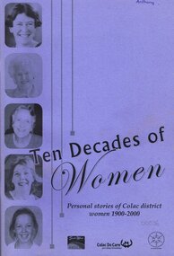
Book, Colac Herald Press, Ten Decades of Women, 2005
A Women's History Month 2005 project recording the stories of 'ordinary' women born between 1900-2000 from the Colac region in south-west Victoria, Australia.Ten decades of women. Personal stories of Colac district women 1900-2000. Margaret Evans. Merrill O'Donnell. Kerri Bauer. 1st ed. Colac (Vic); Colac Herald; 2005. iv, 100 p.; illus. Soft cover.colac district; women; -
 Otway Districts Historical Society
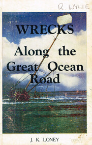
Book, Wrecks along the Great Ocean Road, 1974
... shipwrecks; great ocean road; j.k. loney; west coast...Wrecks along the Great Ocean Road. Shipwrecks of the west... ocean road; j.k. loney; west coast; strandings;portland; port ...Many fine ships were lost along Victoria's western coastline and evidence suggests a number of unidentified wrecks went down many years earlier.Wrecks along the Great Ocean Road. Shipwrecks of the west coast from Point Lonsdale to Portland. J.K. Loney. 4th ed. Dimboola (Vic); J.K. Loney; 1974. iii, 137 p.; illus, maps. Soft cover. ISBN 0 9599853 8 7shipwrecks; great ocean road; j.k. loney; west coast; strandings;portland; port fairy; warrnambool; point lonsdale; -
 Otway Districts Historical Society
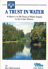
Book, A trust in water, 1990
The harnessing of the bountiful water resources of the Otways as a critical element in the urban and agricultural development of the Colac region.A trust in water. A history of 100 years of water supply to the Colac district. R.J. McCormick. 1st ed. np; R.J. McCormick; 1990. xxii, 324 p.; illus, map. Hard cover. ISBN 0 7241968 2 X a trust in water; r.j. mccormick; colac; water resources; sewerage; west gellibrand dam; otways; -
 Otway Districts Historical Society
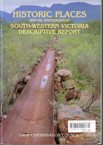
Book, Land Conservation Council, Historic places: Special investigation: South-Western Victoria: Descriptive report, January 1996
... Forest great-ocean-road The south-west of Victoria, possessing ...The south-west of Victoria, possessing a rich heritage of the signs of past human activity, is fertile ground for an investigation of historic places on public land. This report includes an initial inventory of almost 2000 places. The report outlines the history and the related heritage of the area, describes in some detail its biophysical attributes and introduces the natural resources and present land use. This information provides a context for understanding the origins of the historical features that are observes today.Historic places: Special investigation: South-Western Victoria: Descriptive report. Land Conservation Council. Land Conservation Council; Melbourne (Vic); January 1966. viii, 180 p.; illus.; maps. Soft cover. ISBN 0 7241 9288 3Maps in plastic sleeve.land conservation council; conservation; south-western victoria; historic places; -
 Otway Districts Historical Society
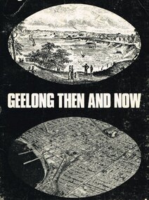
Book, Lothian Publishing Co. Pty. Ltd, Geelong - Then and Now, 1969
Geelong, second city of the state of Victoria, lies some 72 km. south west of Melbourne on the curve of Port Phillip Bay. This short history covers from the aborigines through to the mid-1960. Geelong - Then and Now. C.P. Billot. 1st ed. Melbourne (Vic)203mm x ; Lothian Publishing Co. Pty. Ltd.; 1969. iv, 44p.; illus., map. SBN 85091 109 5geelong; history; aborigines; corio shire; -
 Otway Districts Historical Society
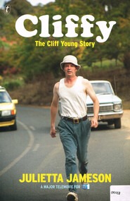
Book, The Text Publishing Company, Cliffy: the Cliff Young story, 2013
Cliff Young was a sixty-one-year-old potato farmer from Beech Forest in the Otway Ranges, a couple of hundred kilometres south-west of Melbourne. With his distinctive shuffle, friendly wave and innocent grin, he beat a field of professional runners to take out the inaugural Westfield Sydney to Melbourne Ultra-marathon starting on April 27 and finishing May 2 in 1983.Cliffy: the Cliff Young story. Julietta Jameson. 1st ed. Melbourne (Vic); The Text Publishing Company; 2013. vi, 218 p.; illus. ISBN 978 1922 0798 6 2 Soft covercliff young; beech forest; sydney; melbourne; ultra-marathon; otways; -
 Otway Districts Historical Society
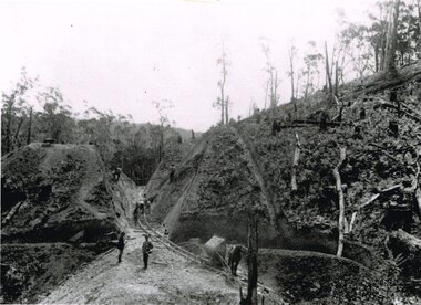
Photograph, Brucker, Powneys Cutting being excavated, c.1902, c.1902
Because of the vast quantity of piles for harbour works Pettit Bros. of Geelong arranged for an addition siding to be installed at Ferguson on the north side of the station in 1913. They then laid a tramway in a northerly direction along the original alignment of Charley's Creek road to the top of Powneys Cutting, 1.8 km from Ferguson, where a log winch was sited. This powerful winch hauled carefully selected piles from the north-west. Jim Facey and Jim, Ted and Tom Cashin formed a partnership to log an area along the Charley's Creek Road six kilometres from Ferguson, operating full-time from 1934. After leasing three Crown sites and cutting them out the partners shifted logging operations to Powneys farm, which they had purchased, and laid a log trail into the farm. The old road reserve was also purchased, and the log tram continued along the road reserve for one kilometre to Powneys Cutting. Logs were winched up to the tramline and despatched to the mill along the falling grade of the road.B/W. 201mm x 268mm. Powneys Cutting being excavated by four men, two men on either side of the slope, and a horse at the end of the line, in c.1902.ferguson; powneys cutting; tramways; powneys farm; pettit; jim facey; jim cashin; ted cashin; tom cashin; charley's creek road; -
 Otway Districts Historical Society
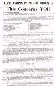
Poster, Colac Herald, Otway Ratepayers' Poll Flyer, 1963, 1963
On 15 January 1964 the Shire of Otway was going to poll its ratepayers about a loan required to build temporary municipal workshops and a Shire Engineer's office in the Apollo Bay Riding. This led to a number of objections at public meetings in the west and central ridings, such that a Committee of protest was formed, with a nominated Chairman, Secretary and members, to put to ratepayers their considered point-of-view of disapproval. After drafts the Committee produced a printed flyer for distribution to ratepayers summarising the Committee's position. The Committee knew and agreed with a Council Sub-Committee's recommendation to Council of a new, adequate building on one site of suitable size. However, this did not happen. Instead Council moved for loans for temporary renovations of existing buildings. This the Committee objected to believing that Council must decide on a final location before any consideration is given to borrowing money for temporary repairs. This was the opinion the Committee put to ratepayers.B/W Flyer. Otway Ratepayers' Poll on January 15. This concerns YOU. To the Ratepayer as addressed. Details on Ballot Paper.ratepayers; shire of otway; -
 Otway Districts Historical Society
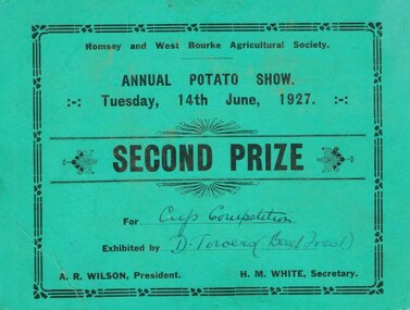
Prize, Romsey and West Bourke Agricultural Society, Potato Show, 1927, 1927
A particular triumph for Alfred Joseph Towers was his win at the Romsey and West Bourke Agricultural Society's Annual Potato Show in 1927, taking the trophy from the best potato growers in Victoria, and from the Romsey district in particular, which at that time was famed for its potato production and quality. His father, David Towers, came second in the cup competion. Romsey and West Bourke Agricultural Society, Annual Potato Show, 14 June 1927, Second Prize, for Cup Competition, exhibited by D. Towers (Beech Forest). A.R. Wilson, President: H.M. White, Secretary.romsey; west bourke; potatoes; prize; -
 Otway Districts Historical Society
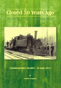
Book, Closed 50 Years Ago. Norman Houghton, 2012
June 2012 represented 50 years since the Colac to Beech Forest to Weeaproinah narrow guage railway was closed. The last goods train ran on 27 June 1962, and the last passenger excursion train on 30 June 1962. The railway was the lifeblood of the West Otways for several decades, enabling farmers and saw millers to bring into economic production the natural wealth of the region. Timber, butter, wool, livestock, potatoes, fodder and minerals flowed out for the benefit of Victorian consumers.Closed 50 years ago. The Colac to Beech Forest narrow guage railway. Commemorative booklet - 30 June 2012. Norman Houghton. Norman Houghton; Geelong (Vic); 2012. iv, 52 p.; illus., maps. Soft cover.colac; beech forest; weeaproinah; railway; -
 Otway Districts Historical Society
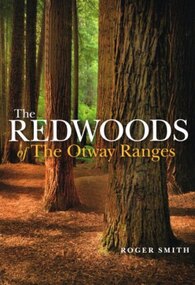
Book, Lothian Custom Publishing, The redwoods of the Otway Ranges. Roger Smith, January 2015
This book is the remarkable story of the world's tallest tree species, the Redwood, growing in the Great Otway National Park in Victoria's south-west. It was originally planted by Victorian foresters for experimental purposes on land abandoned by the early settlers. The Coast Redwood, native of California, is now thrives in the Otways alongside the famous eucalypt, the towering Mountain Ash. The majestic Otway Redwoods, still in their youthful growth phase, have withstood adversity caused by fire, landslide, lighting and chainsaws, while the ongoing political debate about the conservation of the valuable forest resources continues.The redwoods of the Otway Ranges. Roger B. Smith. Lothian Custom Publishing; Middle Park (Vic); 2015. ii, 202 p.; illus., maps, appendices, notes. IBSN 978 1 921737 13 8. Soft cover.With best wishes from Roger Smith. -
 Otway Districts Historical Society
Family History, Colin & Margaret McKenzie, McKenzie, c.2007
Hector McKenzie and Abigail (nee McLean), his wife, lived at Ullapool on the shores of Lochbroom in the far north-west of Scotland. They were married on 8 March, 1821, and had several children. Three of the children, Murdoch and his two sisters, Isabella and Lexcy, emigrated to Australia from Liverpool on the ship "Hornet" on 29 July, 1854, along with 434 other assisted passengers. They arrived at Geelong on 23 October, 1854. Later, Murdoch married a like-named Margaret McKenzie on 23 May, 1861, and had eight children. At the time as the children were thinking about branching out on their own the Otway forest was surveyed and opened for selection. In 1890/91 Murdoch, a son, Duncan, and a daughter, Abigail, selected blocks at Weeaproinah. McKenzie. Colin and Margaret McKenzie. Self published; Weeaproinah (Vic); 2007(?). 54 p.; Illus; maps. Soft cover. Loose-leaf A4. -
 Running Rabbits Military Museum operated by the Upwey Belgrave RSL Sub Branch
Pilot's Map
Part of survival PackPilot's Map of East and West Borneoequipment, ww2, raaf -
 Heytesbury District Historical Society Inc.
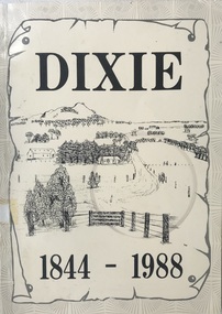
Book, Dixie 1844-1988
Paperback with black and white photographs, large map of County of Heytesbury inside back cover. An account of the settlement of the area known as Dixie in the County of Heytesbury, including pioneers, soldier settlers, the school, churches, sports club etc. during the period from 1844 to 1988. heytesbury shire - history, early settlement - south west victoria, dixie -
 Bendigo Historical Society Inc.
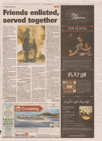
Newspaper - ANZAC COLLECTION: NEWSPAPER CLIPPING RE ENLISTMENT FOR WWI, 2nd August, 2014
Newspaper clipping Bendigo Advertiser Saturday August 2 2014.Articles of friends who enlisted for WWI together. Private George Every, son of W. H. Every enlisted in July 1915, and sailed for Egypt in January 1916, and his imminent return home wounded. Private S. H. R. Elliott No. 782, K.I.A. April 25 1915, aged 28 years. Son of the late Mr. & Mrs George Elliott of Peg leg Road Eaglehawk, enlisted in August 1914 and embarked from Melbourne. N. S. Draper enlisted at the same time. Sydney Elliott was a member of the Eaglehawk Fire Brigade, Rifle club and was chosen to do sniping duty. G. Of the Loyal Catherine lodge, M.U., Odd fellows band , Comrade's class connected with the Eaglehawk West Methodist Sunday School, Church Choir ,Lawn party , and the swastika club, esteem of the Eaglehawk mechanics institute, Foundry man at the Austral Drill foundry at Eaglehawk. He had one sister, Mrs W. Graham, of Peg leg Road and five brothers - Messrs George & Abe, Bootmakers of Eaglehawk, Fred of Vine Street Bendigo, William of Farnsworth Street Eaglehawk,Stanley of Eaglehawk, and well know in musical circles and as choirmaster at St. Pauls Church Bendigo.military, world war 1, bendigo soldiers -
 Bayside Gallery - Bayside City Council Art & Heritage Collection
Map, H.B. Foot, Plan of the Brighton Estate containing 5120 acres, first special survey at Port Phillip, c. 1842
... Road, South Road and to the west by Port Phillip Bay... Melbourne, bounded by North Road, East Boundary Road, South Road ...This plan records the Brighton Estate, also known as Dendy's Special Survey. In 1840 Henry Dendy, a farmer in Surrey, England acquired a "Special Survey" from the Commissioners for Land and Emigration which gave him the right to choose land in Port Phillip for the low price of £1 per acre for 5120 acres. Dendy appointed Jonathan Binns Were, as his agent, who later became a partner. Together, Dendy and Were decided on an area 5 miles south from Melbourne, bounded by North Road, East Boundary Road, South Road and to the west by Port Phillip Bay. Their Brighton Estate was first surveyed by T. S. Townsend in May 1841 and was re-surveyed by Robert Hoddle. Dendy and Were were making plans to sell the land and advertised a 30-guinea prize for the best subdivision which was to be divided into a village, marine residences, suburban and cultivation allotments, with the remainder being divided into country sections. The competition was won by H.B. Foot, who planned the village around a reserve and crescents and a 'green belt' forming the town boundary. brighton estate, dendy's special survey, special survey, henry dendy, jonathan binns were, w.b. were, survey, plan, map, brighton, george ward cole, baker's lithographer, hibernian, subdivision, town planning, cartographic material, h.b. foot -
Bendigo Historical Society Inc.
Document - LYDIA CHANCELLOR COLLECTION: BENDIGO METHODIST CHURCHES PLAN 1905 AND CHURCH OFFICIALS, 1905
LYDIA CHANCELLOR COLLECTION: Bendigo Methodist Churches Plan 1905 and church officials Quarterly Pastoral Visitation of Classes Circuit plan for Forest St, Golden square, Eaglehawk West, Eaglehawk East, California Hill, California Gully, Long Gully, McKenzie St, Galvin St, Rowan St, Arnold St, Iron Bark, Buckly St, Specimen Hill, Quarry Hill, Bridge St, Retreat Road, Kangaroo Flat, Lockwood, East Shelbourne, White Hills, Epsom, Huntly, Bagshot, fosterville, Strathfieldsaye, Axe Creek, sheepwash, Nerring, Leichardt, Leichardt East, Marong, Golden Fleece, Golden Gully, Dowling St Mission, Benevolent Asylum, Hospital Income and Expenditure List of stewards Notices Pastorates Evangelistic Bandsbendigo, history, schooling -
 Ballarat Tramway Museum
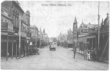
Postcard - Bridge Sreet Ballarat Vic, VSM Melbourne
Postcard - Bridge Sreet, Ballarat Vic showing tram tracks, a number of horse drawn carts and cabs. On the far right, a tram stop sign can be seen, along with men talking. In the view are shops, businesses or advertisements for: Junction Boot Store, Havelock Tobacco, Halls Corner, A Bregeut Ales & Butter shop, W A Stark Wines and Spirits, Velvet Soap, Thomas Dunstan? Leather Merchant.Yields infomation about the corner of Bridge Street, Main Road and Victoria Streets.Black and white postcard titled Bridge Sreet Ballarat Vic, looking west from the corner of Bridge Street, Main Road and Victoria Streets 1910c. Divided back type, published by VSM Melboune and printed in Prussia.bridge street, ballarat, stones corner, victoria street, main road, tramways, tram track, horse drawn vehicles -
Ballarat Tramway Museum
Functional object - Destination Roll, NSW Department of Road Transport and tramways, "Newcastle"
Destination roll use din a Newcastle tram - on linen, black background with various colours and white letters. Each destination 10" high. 6 joins in roll, each approx. 800 to 900 long section. Letters in caps. Destinations shown are: West Wal'send Wallsend and Platsburg New Lambton Lambton Broadmeadow Adamstown Waratah Merewether B'H (Beach) Newcastle Tighe's Hill Mayfield Glebe Boreas Road Special Depot Sport Grd Show Grd Racecourse Speedway Telford St Hamilton Depottram, trams, newcastle, destination roll -
 Kew Historical Society Inc
Plan - Subdivision Plan, J R Mathers & McMillan, Myrtle Hill Estate, East Kew, circa 1949, c.1949
The Kew Historical Society's map collection includes a substantial number of real estate subdivision plans, mainly of Kew but also of surrounding suburbs in Melbourne. Most of the subdivision plans date from the 1920s and 1930s when the districts old homes and local farmland were being split up to accommodate residential growth in the postwar period. These early plans were assembled by a local firm, Jas R Mather & McMillan, which had an office in Cotham Road. Many of the plans, and sometimes photos, were annotated by the agents.Subdivision plans are historically important documents used as evidence for the growth of suburbs in Australia. They frequently provide information about when the land was sold as well as evidence relating to surveyors and real estate and financial agents. The numerous subdivision plans in the Kew Historical Society's collection represent working documents, ranging from the initial sketches made in planning a subdivision to printed plans on which auctioneers or agents listed the prices for which individual lots were sold. In a number of cases, the reverse of a subdivision plan in the collection includes a photograph of a house that was also for sale by the agent. These photographs provide significant heritage information relating house design and decoration, fencing and household gardens.The photograph may also be aesthetically significant depending on the importance of the photographic atelier.Myrtle Hill, at 14 Vista Avenue, Kew, is of local historical and architectural significance as a good example of a large and imposing single-storey Italianate house of the early 1870s surviving in Kew. Originally sited on a large allotment overlooking Normanby Road, the setting of the house has been dramatically altered through extensive subdivision and development. The subdivision plan of the ‘Myrtle Hill Estate’ indicates that in one such subdivision, 11 allotments were created fronting Bowyer Avenue, Myrtle Avenue, and Normanby Road. The outline and building profile of Myrtle Hill is shown on the west side of Bowyer Avenue.The full (typed) title of this subdivision plan is :"Plan of SUBDIVISION of part of CROWN PORTION 83. / at KEW / PARISH OF BOROONDARA. / COUNTY OF BOURKE". / "MYRTLE HILL ESTATE / EAST KEW" In addition to the Title and subtitle, the plan also lists the advantages of the subdivision. -
 Kew Historical Society Inc
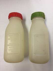
Container - Model Dairy Plastic Milk Bottles, Model Dairy, c.1960
... the Yarra between Studley Park in the west and Burke Road ...This pair of milk bottles, produced for the Model Dairy in Cotham Road, Kew, were donated by Vik Sabaliauskas. They belonged to his father who worked at Model Dairy in the 1950s and 1960s. Vik wrote about his father: "As for my father, his whole life story is interesting. He was part of the big immigration program after WW2. He was a displaced person in Germany like lots of others who came out looking for a new life. Our family name is actually SABALIAUSKAS which is of Lithuanian descent. My Dad was also named Vik (Viktoras). He was known as Big Vik and I was little Vik. He arrived in Australia in 1947 and then did his 2 years of work organised by the Government and then he came to Melbourne. We lived in Tyler St Preston and he rode his pushbike to and from Kew every working day for years. In my estimation that was about 13 kms for about 6 or 7 years. Imagine that happening today. Freezing Winter mornings and hot Summer afternoons. His English was poor but he had a great work ethic like all European immigrants. His duties related to maintaining and operating all the machines. One story that he told me about was that after I was born (in 1959) he made friends with one of the drivers who delivered milk to the dairy. He asked him to get a container of milk from the farmer everyday which was just for me. I remember going to the Model Dairy Family Christmas parties which were always well patronised. I also remember visiting him in the PANCH Hospital (Bell Street Preston) where he was treated for kidney stones caused by drinking very creamy milk. He wasn't happy when he was told by the doctor to cut back on milk. My Dad was one month short of his 95th birthday when he died and he lived a pretty healthy life." (2019)Kew was a major milk producing district in the Nineteenth and early Twentieth centuries, with three major dairy farms lining the Yarra between Studley Park in the west and Burke Road in the east. In addition to these dairy producers, there were also a number of accredited dairy retailers in the suburb. The largest and most enduring of these was the Model Dairy founded by the Kew pioneer James Venn Morgan. Milk bottles that include the name of the producer or retailer are historically significant as they represent a period in Kew's history before the mass production of milk in the second half of the Twentieth Century. A number of these named bottles have the additional attribute of rarity.Pair of plastic milk bottles, designated on the front as to be used in the refigerator on on picnics. One bottle has a red screw on lid and the other a green lid. The bottles are semi-transparent. [The record also includes a photograph of Vic Sabaliauskas, provided by his son. The photograph dates from the period when he was employed at the Model Dairy].Impressed on the front of both bottles: "Unbreakable picnic and refrigerator bottle made expressly for Model Dairy Pty Ltd Cotham Rd Kew"dairies - kew, model dairy - cotham road - kew (vic) -
Kew Historical Society Inc
Archive (series) - Subject File, Adeney, William, 1971
Various PartiesReference, Research, InformationKHS OrderReference file containing items of correspondence from 1971 relating to a query regarding the life of William Adeney, of Clifton Villa, Cotham Road. Researcher name - John Adeney. Response from Mrs E. West, KHS Secretary. The file contains snippets of original research on Adeney (Rate Books - William Adeney, Park Street (later Adeney Avenue) 1878. The response refers to memories by Frances Dumaresq who knew the descendants.william adeney, adeney avenue - kew (vic.), clifton villa - cotham road - kew (vic.)william adeney, adeney avenue - kew (vic.), clifton villa - cotham road - kew (vic.) -
 Kew Historical Society Inc
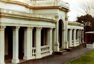
Photograph - Façade of ‘Southesk', Cotham Road, Stewart West, 1970
... . Photograph Façade of ‘Southesk', Cotham Road Stewart West ...Colour enlargement of a photograph (slide) of Southesk (formerly Ordsall) in Cotham Road, Kew (demolished 1970).A colour photograph of the façade of ‘Southesk’ taken at an oblique angle. Formerly known as ‘Ordsall’, the house was built for John Halfey in 1882 on the corner of Cotham Road and Charles Street. The Italianate mansion was built in the Renaissance villa style on a bluestone plinth. Two balustrades surrounded the parapet of the roof and ran between the groups of pillars on either side of the entrance porch. The verandah was tiled and wide and Corinthian columns supported its roof. When the house passed into the hands of the City of Kew in 1948, the Council used it for a kindergarten, an elderly citizen centre and as a home for the Leo Baeck Centre. The house was demolished in 1970.david carnegie, john halfey, southesk - cotham road - kew (vic), ordsall - cotham road - kew (vic) -
 Kew Historical Society Inc
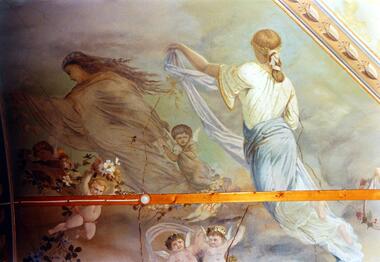
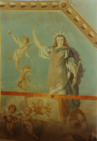
Photograph - Ceiling fresco, Ballroom, ‘Southesk’, Cotham Road, Stewart West, 1970
... Road Stewart West ...Colour enlargement of a photograph (slide) of Southesk (formerly Ordsall) in Cotham Road, Kew (demolished 1970).The ceilings of and architraves of Ordsall were painted by artists employed by the decorating company, Cullis Hill & Co. The frescos, of which fragments survive, were some of the most important murals used as elements of interior decoration in Melbourne during the Boom Period of the 1880s. These photographs were taken immediately prior to the demolition of the house, and are the best examples of the murals.Notwithstanding its grand Italianate façade, the most important aspect of Southesk (formerly ‘Ordsall’) were the murals in the front two rooms. An article in the Melbourne Argus in 1882 records that Mr Vandenbrandt and Signor Rizzi created these under the supervision of Cullis Hill. This fresco from the ceiling of the ballroom depicts ‘Night, represented by a female figure in a diaphanous garment, skirted with flowers, wafted before the approaching dawn into space illuminated by the moonlight, and peopled by the fairies, is a striking picture. Flying with her are an attendant Cupid bearing an artificial light, and a tired little votary of Bacchus with a reversed wine-pitcher and goblet’.david carnegie, john halfey, southesk - cotham road - kew (vic), ordsall - cotham road - kew (vic) -
 Kew Historical Society Inc
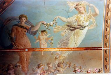
Photograph - Ceiling fresco, Ballroom, ‘Southesk’, Cotham Road, Stewart West, 1970
... , Ballroom, ‘Southesk’, Cotham Road Stewart West ...Colour enlargement of a photograph (slide) of Southesk (formerly Ordsall) in Cotham Road, Kew (demolished 1970).The ceilings of and architraves of Ordsall were painted by artists employed by the decorating company, Cullis Hill & Co. The frescos, of which fragments survive, were some of the most important murals used as elements of interior decoration in Melbourne during the Boom Period of the 1880s. These photographs were taken immediately prior to the demolition of the house, and are the best examples of the murals.The most significant decorative aspects of Southesk (formerly ‘Ordsall’) were the murals in the front two rooms. An article in the Melbourne Argus in 1882 records that Mr Vandenbrandt and Signor Rizzi created these under the supervision of Cullis Hill. This fresco from the ceiling of the ballroom is believed to depict two of the Seasons. Signor Rizzi was a renowned painter of flowers. He is credited with painting these parts of the murals. Examples of his floral paintings can still be seen at Villa Alba in Walmer Street.david carnegie, john halfey, southesk - cotham road - kew (vic), ordsall - cotham road - kew (vic) -
 Kew Historical Society Inc
Photograph - Ceiling fresco, Ballroom, ‘Southesk’, Cotham Road, Stewart West, 1970
... Ceiling fresco, Ballroom, ‘Southesk’, Cotham Road Stewart West ...Colour enlargement of a photograph (slide) of Southesk (formerly Ordsall) in Cotham Road, Kew (demolished 1970).The ceilings of and architraves of Ordsall were painted by artists employed by the decorating company, Cullis Hill & Co. The frescos, of which fragments survive, were some of the most important murals used as elements of interior decoration in Melbourne during the Boom Period of the 1880s. These photographs were taken immediately prior to the demolition of the house, and are the best examples of the murals.The most significant decorative aspects of Southesk (formerly ‘Ordsall’) were the murals in the front two rooms. An article in the Melbourne Argus in 1882 records that Mr Vandenbrandt and Signor Rizzi created these under the supervision of Cullis Hill. This fresco from the ceiling of the ballroom is believed to depict ‘Africa’. The article records that: ‘Notwithstanding the large size of the drawings they are often marked by delicate touches, and a minuteness of detail in evident sympathy with nature. The figures have grace, life and animation and the skillful shading of the colours used — chiefly amber, gold, light blue, green, light fawn and brown – is in harmony with the quiet tone of the general furnishing of the rooms.’david carnegie, john halfey, southesk - cotham road - kew (vic), ordsall - cotham road - kew (vic) -
 Kew Historical Society Inc
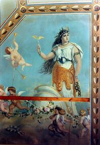
Photograph - Ceiling fresco, Ballroom, ‘Southesk’, Cotham Road, Stewart West, 1970
... ’, Cotham Road Stewart West ...Colour enlargement of a photograph (slide) of Southesk (formerly Ordsall) in Cotham Road, Kew (demolished 1970).The ceilings of and architraves of Ordsall were painted by artists employed by the decorating company, Cullis Hill & Co. The frescos, of which fragments survive, were some of the most important murals used as elements of interior decoration in Melbourne during the Boom Period of the 1880s. These photographs were taken immediately prior to the demolition of the house, and are the best examples of the murals.The most significant decorative aspects of Southesk (formerly ‘Ordsall’) were the murals in the front two rooms. An article in the Melbourne Argus in 1882 records that Mr Vandenbrandt and Signor Rizzi created these under the supervision of Cullis Hill. This fresco from the ceiling of the ballroom is believed to depict one of the ‘boldly drawn four great geographical divisions of the Earth’. The crowned woman, believed to represent Europe, stands aloft in a chariot drawn by cherubs holding garlands of flowers.david carnegie, john halfey, southesk - cotham road - kew (vic), ordsall - cotham road - kew (vic) -
 Kew Historical Society Inc
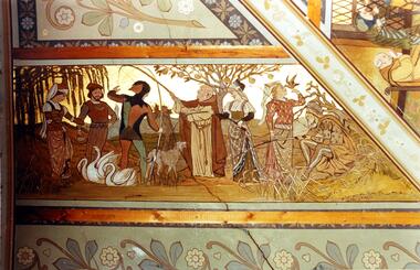
Photograph - Ceiling fresco, Drawingroom, ‘Southesk’, Cotham Road, Stewart West, 1970
... Ceiling fresco, Drawingroom, ‘Southesk’, Cotham Road Stewart West ...Colour enlargement of a photograph (slide) of Southesk (formerly Ordsall) in Cotham Road, Kew (demolished 1970).The ceilings of and architraves of Ordsall were painted by artists employed by the decorating company, Cullis Hill & Co. The frescos, of which fragments survive, were some of the most important murals used as elements of interior decoration in Melbourne during the Boom Period of the 1880s. These photographs were taken immediately prior to the demolition of the house, and are the best examples of the murals.The most significant decorative aspects of Southesk (formerly ‘Ordsall’) were the murals in the front two rooms. An article in the Melbourne Argus in 1882 records that Mr Vandenbrandt and Signor Rizzi created these under the supervision of Cullis Hill. This fresco from the ceiling of the drawingroom was described by the reporter as ‘done in the quaint old 14th century style’. This section depicts ‘out-door sports. The fishing-lines of the jester and the almoner have become entangled, and a large wolf-dog seems disposed to arbitrate in the difficulty, while a party of young men and maidens are angling, feeding swans, or training hawks for a future day’s sport.’david carnegie, john halfey, southesk - cotham road - kew (vic), ordsall - cotham road - kew (vic) -
 Kew Historical Society Inc
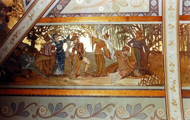
Photograph - Ceiling fresco, Drawingroom, ‘Southesk’, Cotham Road, Stewart West, 1970
... , ‘Southesk’, Cotham Road Stewart West ...Colour enlargement of a photograph (slide) of Southesk (formerly Ordsall) in Cotham Road, Kew (demolished 1970).The ceilings of and architraves of Ordsall were painted by artists employed by the decorating company, Cullis Hill & Co. The frescos, of which fragments survive, were some of the most important murals used as elements of interior decoration in Melbourne during the Boom Period of the 1880s. These photographs were taken immediately prior to the demolition of the house, and are the best examples of the murals.The most significant decorative aspects of Southesk (formerly ‘Ordsall’) were the murals in the front two rooms. An article in the Melbourne Argus in 1882 records that Mr Vandenbrandt and Signor Rizzi created these under the supervision of Cullis Hill. This fresco from the ceiling of the drawingroom was described by the reporter as ‘done in the quaint old 14th century style … The second panel represents a hawking party. The ladies hold aloft the natural perches for their falcons. The men, seated in picturesque variety of attitude, hold their cross-bows, and a boy is relieving a heron from an arrow which has pierced its bosom.’david carnegie, john halfey, southesk - cotham road - kew (vic), ordsall - cotham road - kew (vic) -
 Kew Historical Society Inc
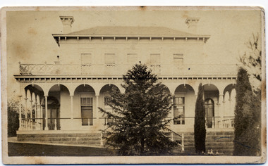
Photograph - 'Clutha', Studley Park Road, 1860-1890
... "Clutha West Side Studley Park Road Kew / Clutha West Side"... Road Kew / Clutha West Side" A rare, nineteenth century ...Clutha was the home of John Carson, the second mayor of Kew. Leonard Terry designed the house for him in 1856. Terry was the architect of the Melbourne Club (1858), the former London Chartered Bank (1861), Lothian Terrace in Carlton (1865), and the ES&A Bank in Hawthorn (1873). The commission for Clutha was won three years after Terry’s arrival in Victoria.An extremely rare photograph of a major residential architectural commission of Leonard Terry. The photograph of the house has statewide significance as the home of the Victorian pioneer and businessman, John Carson. A rare, nineteenth century photograph of ‘Clutha’ in Studley Park Road, Kew. The sepia-toned photograph is of the front of the house, with its bluestone foundations and its second storey balcony. A real estate advertisement in 1875 described the house as: 'First-class family mansion, and about 8½ acres of pleasure grounds and fruit garden. The house, erected under the plans and supervision of Mr. Leonard Terry, is most substantially built of brick, stuccoed, on solid bluestone pediment, forming a noble basement story, large entrance hall, and lobby, with conservatory on the left. *** A wide verandah and balcony, erected on cast-iron columns, runs round the house, the views from which are perhaps unequalled in extent and beauty in the neighbourhood of the city, commanding the bay, shipping, Mount Macedon, and Dandenong Ranges. Th e whole forming a most complete gentleman's residence, no expense having been spared in its erection and comfortable finish.'"Clutha West Side Studley Park Road Kew / Clutha West Side"clutha, john carson, leonard terry