Showing 3783 items
matching 1972
-
 Bendigo Military Museum
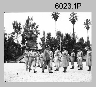
Photograph - Royal Australian Survey Corps Colonel Commandant and Director of the Survey Corps, c1960, 1962, c1969
COL Lawrence FitzGerald OBE was Director of the Survey Corps from 1942 to 1960 and was succeeded by COL Don Macdonald AM, MID. COL Frank Buckland OBE, MID succeeded BRIG Don Macdonald AM, MID as Director of the Survey Corps in 1967. He served as Director until 1972. BRIG Macdonald AM, MID was promoted before assuming the honorary position of Colonel Commandant of the Royal Australian Survey Corps. Royal Australian Survey Corps Colonel Commandant and Director of the Survey Corps c1969 at the Army Headquarters Survey Regiment, Fortuna Villa, Bendigo. .1 Black and white photograph: The Director of the Survey Corps COL Lawrence FitzGerald OBE inspecting the troops. Taken in c1960 on the parade ground at Fortuna Villa. .2 Black and white photograph: L to R: Director of the Survey Corps BRIG Don Macdonald AM, an unidentified British Officer and the CO Army Headquarters Survey Regiment LTCOL Tim Tyler. Taken in 1962 inside the Officers Mess at Fortuna Villa. .3 Black and white photograph: L to R: Colonel Commandant BRIG Don Macdonald AM and the Director of the Survey Corps COL Frank Buckland OBE. Taken in c1969 at the front steps to Fortuna Villa..1 no annotation 2.P named personnel annotated on paper sleeve, .3 named personnel annotated on back royal australian survey corps, rasvy, army survey regiment, army svy regt, fortuna, asr -
 Uniting Church Archives - Synod of Victoria
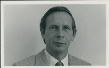
Photograph, Rev G F Brookes, Undated
Rev G F Brookes was ordained in 1968 in NSW, his first ministry was Bulli 1967-1968, followed by Cooma-Bombala 1969-1972, Kempsey- Gladstone 1973, OD Indonesia Kupang 1974-1977. He returned to NSW in 1978 when he went to Armidale where he stayed until 1985. He then joined the Commission for Mission from 1986 to October 1998, and Lakemba 11/1998.B&W head and shoulders photo of Rev. G.F. Brookes, wearing coat and tie.rev g f brookes, uca commission for mission -
 Robin Boyd Foundation
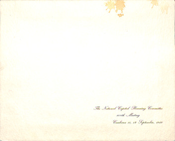
Photograph
On the cover 'The National Capital Planning Committee 10th meeting Canberra 11,12 September, 1969'. Mr John Overall, the inaugural Commissioner of the National Capital Planning Committee (1957-1972), sits at the Head of the table. Robin Boyd is on the right of John Overall. At the far right is Sir Daryl Lindsay, Chair of the Commonwealth Art Advisory Board and past the Director of National Gallery of Victoria. The architect Sir Osborn McCutcheon is on the far left.Black and white photograph (190mm H x 245mm W) in a presentation folder. Liquid splashes on top right.the national capital planning committee, mr john overall, robin boyd, sir osborn mccutcheon -
 Mt Dandenong & District Historical Society Inc.
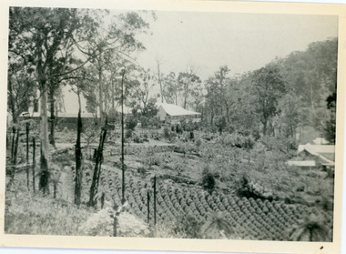
Photograph, View of Kalorama Gap 1905
Kalorama Gap viewed from the South West in 1908. Ellis Jeeves' 'Mountjoy' is in the centre with the stables to the left. The raspberry patch belongs to Harry Walker and the building centre right to Edward Joseph Price. John Lundy-Clarke grew up in the Kalorama/Mt Dandenong area and later in life (1972-74) began to write a comprehensive history of the area working from an original settlement map in an effort to cover all areas.Black and white photograph showing an extensive raspberry crop in the foreground with a house and outbuilding in the centre and another dwelling centre right. Handwritten description on reverse by John Lundy-Clarke. 1908 view of Kalorama Gap taken from corner of Village Settlement LOTS 2 and 3 on Ridge (then Main Road) which crosses centre of picture with Walker’s driveway dropping left. Walker’s raspberry patch in foreground. “Mountjoy” in centre of picture with coaching stables on left. Price’s house and shop on right showing large cross room used by the Village Settlers for dancing. Mrs Hand’s “Beulah Tearooms” later Mt Dandenong North Post Office is above Price’s roof.kalorama gap, kalorama, harry walker, walker, edward joseph price, raspberry, mountjoy -
 Kew Historical Society Inc
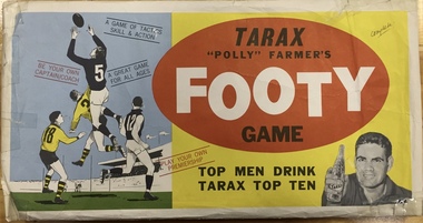
Leisure object - Board Game, F W Niven Pty Ltd, Tarax "Polly" Farmer's Footy Game, c 1965
Tarax was an independent Melbourne soft drink manufacturer from 1959 to 1972 (when it was taken over by Cadbury Schweppes). It was most popular as a product in the 1960s when it sponsored by the Tarax Show; a very popular children's television program. In the 1960s Polly Farmer was a star Geelong footballer. He played in a premiership team and was captain for 3 years. The game originally cost 75 cents plus 6 Tarax bottle tops. Boxed board game with yellow, blue and red lid. board games, tarax, polly farmer, f.w. niven, aboriginal footballer, victorian football league, australian football league, aboriginal and torres straight islander -
 National Wool Museum
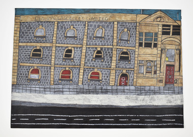
Drawing, Christian Den Besten, National Wool Museum, 2019
Christian Den Besten was Born 1972. Through art Christian interprets his community - the current affairs, infrastructure, and people that affect his everyday life. He is a prolific artist and often works with an accumulation of small components in creating his artworks. Christian is an artist living with an intellectual disability. He takes pleasure in drawing the beautiful buildings that dot Geelong’s cityscape. He exhibits and sells his work regularly.Denny’s Lascelles building Geelong by Christian Den Besten, 2019. -
 Federation University Art Collection
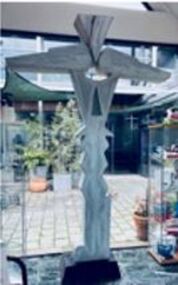
Sculpture, Adrian Mauriks, 'Totem' by Adrian Mauriks, 1998
Adrian MAURIKS (1942-2020) Born Holland Arrived Australia 1957 Adrian Mauriks completed Undergraduate and Post Graduate at the Victorian College Of The Arts, Melbourne, Victoria between 1972 and 1978. In 1978 Adrian Mauriks was appointed to the School of Visual Arts at the Gippsland Institute of Education in Churchill (now Federation University). He lectured in a number of univeristies before retiring in 1996, including the University of Ballarat (now Federation University)Timber made of painted cypress pineadrian mauriks, sculpture -
 City of Greater Bendigo - Civic Collection
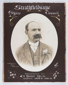
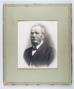
Photograph - Portrait of Councillor Keck, W H Robinson, c 1913
The district of Strathfieldsaye was proclaimed in 1861 and named a Shire on the 17th September in 1866. It remained a shire until amalgamation in 1994 when it became part of the City of Greater Bendigo. The shire was located 8 km to the south- east of Bendigo and covered an area of 601 square kilometres and extended from the Calder Highway to the Coliban and Campaspe Rivers. The shire's administration centre was in Strathfieldsaye until 1972 when new offices were opened in Kennington.Framed black and white head and shoulder portrait of Councillor Keck with hand coloured and drawn detail. Profile slightly to right with walrus moustache. Cut oval brown mount decorated with text and flowers. Hand written title top and lower centre.Strathfieldsaye / Shire Council / W.H. Robinson / Photo / Bendigo / J.H.E Gribbs / Presented by / Cr Herbert Keck / President 1903-4. 1912-13.shire of strathfieldsaye, councillor keck, strathfieldsaye shire council, president of strathfieldsaye shire -
 City of Greater Bendigo - Civic Collection
Photograph - Councillor group portrait, W H Robinson, Strathfieldsaye Shire Council, 1909
The district of Strathfieldsaye was proclaimed in 1861 and named a Shire on the 17th September in 1866. It remained a shire until amalgamation in 1994 when it became part of the City of Greater Bendigo. The shire was located 8 km to the south- east of Bendigo and covered an area of 601 square kilometres and extended from the Calder Highway to the Coliban and Campaspe Rivers. The shire's administration centre was in Strathfieldsaye until 1972 when new offices were opened in Kennington.Photographic group portrait of eleven Strathfieldsaye Shire Councillors in front of the Strathfieldsaye Shire Hall. Five men are seated and six standing with one man standing further in back ground on the building's verandah. Photograph is attached directly to green mount card and framed. Gold lettering on mount.Strathfieldsaye Shire Councillors / R. B. Brennan (Sec.) W. J. Lowdes S. Doak M. Burns () N Condon B. Code (Inspector) / WH Robinson Photo Bendigo / T Somerville / W. I. Long / Fred Osborne (President) H Keck / W Dresler / With the President's (Cr. Fred Osborne) Compliments / September 23rd, 1909shire of strathfieldsaye, strathfieldsaye shire council, president of strathfieldsaye shire, strathfieldsaye shire hall -
 City of Greater Bendigo - Civic Collection
Photograph - Strathfieldsaye Councillor Group Portrait, D.G. Coope & Son - Framers
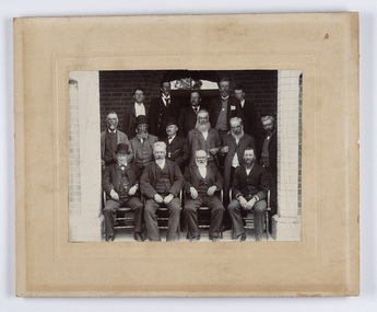
The district of Strathfieldsaye was proclaimed in 1861 and named a Shire on the 17th September in 1866. It remained a shire until amalgamation in 1994 when it became part of the City of Greater Bendigo. The shire was located 8 km to the south- east of Bendigo and covered an area of 601 square kilometres and extended from the Calder Highway to the Coliban and Campaspe Rivers. The shire's administration centre was in Strathfieldsaye until 1972 when new offices were opened in Kennington.Silver gelatin framed photographic group portrait of fifteen men taken in the alcove of the Strathfieldsaye Shire Hall. Four men are seated and eleven are standing. Photograph is attached directly to cream mount card. Handwritten note with photograph: 1/ John Burke, 2/ (?), 3/ (?), 4/ RHS Abbott, 5/ M Brennan, 6/(?) 7/(?) 1/. M Condon? 2/ (?) 3/ M Burns, 4/(?) Gentlemen at back probably are council staff.shire of strathfieldsaye, strathfieldsaye shire council, president of strathfieldsaye shire, councillor john burke, councillor r.h.s. abbott, councillor brennan, councillor condon, councillor m burns -
 City of Greater Bendigo - Civic Collection
Photograph - Councillor group portrait, W H Robinson, Strathfieldsaye Shire Council
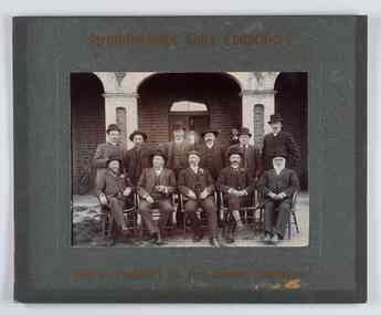
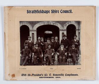
The district of Strathfieldsaye was proclaimed in 1861 and named a Shire on the 17th September in 1866. It remained a shire until amalgamation in 1994 when it became part of the City of Greater Bendigo. The shire was located 8 km to the south- east of Bendigo and covered an area of 601 square kilometres and extended from the Calder Highway to the Coliban and Campaspe Rivers. The shire's administration centre was in Strathfieldsaye until 1972 when new offices were opened in Kennington. Group portrait of 13 men / councilors, 5 seated and 8 standing dressed in suits. There are another 2 men further back in front of the hall doors. Photograph is taken outside the Strathfieldsaye Shire Hall.Srathfieldsaye Shire Council. / With the President's (Cr T. Somerville) Compliments. / September, 1910 / W.H. Robinson Photo. Bendigo Verso; William Drechslershire of strathfieldsaye, president of strathfieldsaye shire, strathfieldsaye shire council -
 City of Greater Bendigo - Civic Collection
Photograph - Portrait of Councillor Burke
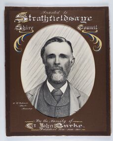
The district of Strathfieldsaye was proclaimed in 1861 and named a Shire on the 17th September in 1866. It remained a shire until amalgamation in 1994 when it became part of the City of Greater Bendigo. The shire was located 8 km to the south- east of Bendigo and covered an area of 601 square kilometres and extended from the Calder Highway to the Coliban and Campaspe Rivers. The shire's administration centre was in Strathfieldsaye until 1972 when new offices were opened in Kennington. Framed black and white head and shoulder portrait of Councillor Burke with hand coloured and drawn detail. Profile centre facing with beard. Cut oval brown mount decorated with text and fscrolls. Hand written title top and lower centre. Wooden frame with detail and gold inner.Presented to Strathfieldsaye / shire Council / w. H. robinson / Photo / Bendigo / By the family of / Cr John Burke / President 1890 - 1899 - 1900strathfieldsaye shire council, councillor burke, president of strathfieldsaye shire -
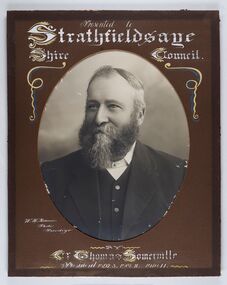 City of Greater Bendigo - Civic Collection
Photograph - Portrait of Councillor Thomas Somerville, W H Robinson
The district of Strathfieldsaye was proclaimed in 1861 and named a Shire on the 17th September in 1866. It remained a shire until amalgamation in 1994 when it became part of the City of Greater Bendigo. The shire was located 8 km to the south- east of Bendigo and covered an area of 601 square kilometres and extended from the Calder Highway to the Coliban and Campaspe Rivers. The shire's administration centre was in Strathfieldsaye until 1972 when new offices were opened in KenningtonFramed black and white head and shoulder portrait of Councillor Somerville with hand drawn detail. Profile slightly to left, face has full beard. Cut oval brown mount decorated with text and scrolls. Hand written title top and lower centre.Presented to / Strathfieldsaye / Shire Council / W. H. Robinson / Photo / Bendigo / by / Cr Thomas Somerville / President 1892 - 3. 1901.2. 1910.11 strathfieldsaye shire council, councillor somerville, president of strathfieldsaye shire -
 City of Greater Bendigo - Civic Collection
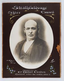
Photograph - Portrait of Councillor Michael Condon, W H Robinson
The district of Strathfieldsaye was proclaimed in 1861 and named a Shire on the 17th September in 1866. It remained a shire until amalgamation in 1994 when it became part of the City of Greater Bendigo. The shire was located 8 km to the south- east of Bendigo and covered an area of 601 square kilometres and extended from the Calder Highway to the Coliban and Campaspe Rivers. The shire's administration centre was in Strathfieldsaye until 1972 when new offices were opened in KenningtonFramed black and white head and shoulder portrait of Councillor Condon with hand coloured and drawn detail. Profile slightly to left. No facial hair. Cut oval brown mount decorated with text, scrolls and flowers. Hand written title top and lower centre.Strathfieldsaye / Shire / Council / W. H. Robinson / Photo / Bendigo / JMB Gribble / Presented by / Cr Michael Condon / President 1889 - 90. 1895-6. 1904 - 5strathfieldsaye shire council, president of strathfieldsaye shire, councillor condon -
 City of Greater Bendigo - Civic Collection
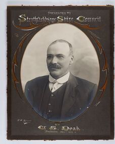
Photograph - Portrait of Councillor Doak, W H Robinson
The district of Strathfieldsaye was proclaimed in 1861 and named a Shire on the 17th September in 1866. It remained a shire until amalgamation in 1994 when it became part of the City of Greater Bendigo. The shire was located 8 km to the south- east of Bendigo and covered an area of 601 square kilometres and extended from the Calder Highway to the Coliban and Campaspe Rivers. The shire's administration centre was in Strathfieldsaye until 1972 when new offices were opened in Kennington.Framed black and white head and shoulder portrait of Councillor Doak with hand coloured and drawn detail. Left facing profile with walrus moustache. Cut oval brown mount decorated with text and scrolls. Hand written title top and lower centre.Presented to / Strathfieldsaye Shire Council / W. H. Robinson / Photo / JMB Gribble / by Cr S. Doak / President 1911 - 1912strathfieldsaye shire council, president of strathfieldsaye shire, councillor doak -
 City of Greater Bendigo - Civic Collection
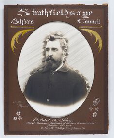
Photograph - Portrait of Councillor Sibley, W H Robinson
The district of Strathfieldsaye was proclaimed in 1861 and named a Shire on the 17th September in 1866. It remained a shire until amalgamation in 1994 when it became part of the City of Greater Bendigo. The shire was located 8 km to the south- east of Bendigo and covered an area of 601 square kilometres and extended from the Calder Highway to the Coliban and Campaspe Rivers. The shire's administration centre was in Strathfieldsaye until 1972 when new offices were opened in KenningtonFramed black and white head and shoulder portrait of Councillor Sibley with hand coloured and drawn detail. Profile slightly to left with walrus moustache and beard. Cut oval brown mount decorated with text, flowers and scrolls. Hand written title top and lower centre.Strathfieldsaye / Shire Council / W m Robinson / Photo / Bendigo / J N B Gribble / Cr Robert R Sibley / First President Chairman of the Road Board 1865 - 5 / President 1866 - 1869 / With Mrs Sibley's Complimentsstrathfieldsaye shire council, councillor sibley, president of strathfieldsaye shire -
 City of Greater Bendigo - Civic Collection
Photograph - Portrait of Councillor Long, Talma & Co
The district of Strathfieldsaye was proclaimed in 1861 and named a Shire on the 17th September in 1866. It remained a shire until amalgamation in 1994 when it became part of the City of Greater Bendigo. The shire was located 8 km to the south- east of Bendigo and covered an area of 601 square kilometres and extended from the Calder Highway to the Coliban and Campaspe Rivers. The shire's administration centre was in Strathfieldsaye until 1972 when new offices were opened in Kennington.Framed black and white head and shoulder portrait of Councillor Long. Profile to left with walrus moustache and mutton chops. Cut olive retangle mount. Verso; Long. On under board which has photograph attached; Talma & Co. / 119 Swanston St., / Melbournestrathfieldsaye shire council, councillor long -
 City of Greater Bendigo - Civic Collection
Photograph - Portrait of Councillor Hargraves, Bartlett Bros
The district of Strathfieldsaye was proclaimed in 1861 and named a Shire on the 17th September in 1866. It remained a shire until amalgamation in 1994 when it became part of the City of Greater Bendigo. The shire was located 8 km to the south- east of Bendigo and covered an area of 601 square kilometres and extended from the Calder Highway to the Coliban and Campaspe Rivers. The shire's administration centre was in Strathfieldsaye until 1972 when new offices were opened in KenningtonFramed black and white head and shoulder portrait of Councillor Hargraves. Profile slightly to right with walrus moustache. Cut rectangle brown mount decorated with coloured text and scrolls. Hand written title top and lower centre.Strathfiledsaye Shire Council / Cr John Hargreaves / President 1919 - 20 1928 - 29 / Presented by his Wife & Familystrathfieldsaye shire council, president of strathfieldsaye shire, councillor hargreaves -
 City of Ballarat
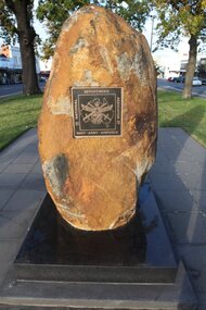
Public Artwork, National Servicemens' Association Memorial, 2008
This shaved rock bears witness to the sacrifice of soldiers during compulsory conscription for several periods of Australia’s War History. This item is of historic significance to the people of BallaratLarge shaved rock with plaque recognising compulsory conscription of soldiers.This memorial commemorates the sacrifice and service of those men from Ballarat and District conscripted for National Service during the years 1951 and 1959, and 1965 and 1972. Unveiled by the Hon Tony Robinson MP Minister assisting the Premier on Veterans` Affairs 3 February 2008. Erected by the Ballarat and Districts sub-branch of the National Servicemen`s Association of Australia. SERVICE TO THE NATIONnational service, sacrifice of soldiers -
 Melbourne Legacy
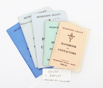
Booklet, Handbook for Contactors, 1x1959, 1x1961, 1x1996, 2x1972
A handbook is issued to all Legatees to assist them with their work with the legacy widows; eg childrens' education, welfare, accommodation, health. A quick easy guide to services provided by Melbourne Legacy such as bursaries, medical care, financial assistance etc for Legatees use. It was reissued annually for many years prior to keeping this information electronically. Many issues are held at 00002 and 01080. Chapters of the book include the following, many of which are committees: Administration Anzac Day Observance Comradeship. 'Comradeship is an integral and important part of Legacy. This committee's function is primarily to arrange social and other activities which bring members together so that they become known to each other on an intimate and friendly basis; and so that when a member strikes a problem, he immediately knows with whom he might get into touch to discuss it in then spirit of mutual assistance.' Finance Huntingdale (Golf Club) Intermediate Legacy Liaison Personnel Committee Programme Committee Dealing with the Junior Legacy Committee: Boys' Group Camps and holidays Christmas party Contact Cultural and Library Dental Demonstration Education Employment Firewood Girls' Group Housing and accomodation Legal Longbank (holiday home for widows in need of a rest) Medical Newsletter Older widows Optometrists Pensions Probation Residences Special cases Welfare Appendix A Allowances for school requisites Appendix B Scholarships Appendix C Pensions / War widows pensions / Commonwealth widows pensions / Immediate assistance SCTF Appendix D Repatriation Department Appendix E Commonwealth Social Services Appendix F CWD - Children's Welfare Department Appendix G Hospital and medical benefits for Legacy Widows and their dependants Appendix H AMF Relief Trust Fund Appendix I SCTF - Services Canteen Trust Fund Appendix J Sir Samuel McCaughey Bequest Appendix K Various sources of assistance available (eg clothing, blankets, POW associations, RSL, conveyance allowances.)This booklet assisted legatees locating services available to widows and children from within Legacy or government departments.Five copies of the Handbook for Contactors. Different covers from different dates, 1 green, 1 apricot, 2 grey, 1 blue.2 x Melbourne Legacy, Legacy logo, Handbook for Contactors, Issued with Melbourne Legacy Diary 1959/1961-62. 2 x Melbourne Legacy, Legacy logo Handbook for Contactors, For use in conjunction with Melbourne Legacy Diary 1972. 1 x Melbourne Legacy, Legacy logo, Handbook for Contactors, For use in conjunction with Melbourne Legacy Diary 1966.regulations, objectives, rules, register -
 Ballarat Tramway Museum
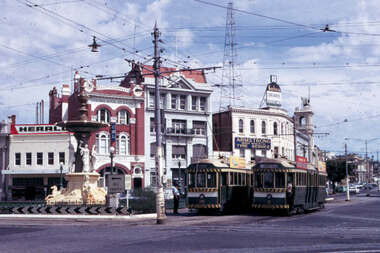
Slide - 35mm slide/s - set of 12, Noel Simons, 28 Feb. 1972
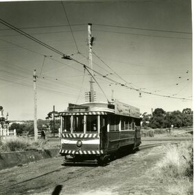
Set of 12 transparencies taken on 28/2/1972 on Kodak mounts. 1207.1 - Bendigo 26 and 2 at Charing Cross. 26 en route for Eaglehawk, 2 for Quarry Hill. Has the Colonial Mutual Life, Armstrong Tyre Service, and Australian Mutual Provident Society buildings and a Cohns Drinks ad. in the background. 1207.2 - as for 1207.1 but with Alexandra fountain in the foreground. 1207.3 - No. 2 in Mitchell St. heading for Quarry Hill. Photo taken after tram has passed photographer. Has buildings on either side of Mitchell St. in the background, including the Plaza Theatre. 1207.4 - No. 6 en route for Golden Square departing Charing Cross. Has the RACV and ANZ bank in the background. 1207.5 - No. 2 crossing Pall Mall to enter Charing Cross ex Quarry Hill, with the Fountain Plaza in the background. 1207.6 - No. 6 arriving Charing Cross ex Golden Square with No. 21 alongside. No. 21 has the SEC ad. 'Everything's fine in my all electric kitchen.' Has the City Family Hotel and the Fountain Plaza shopping centre in the background. 1207.7 - No. 5 at Charing Cross en route for Quarry Hill with No. 2 behind. No. 2 has two SEC roof ads, 'Everything s fine in my all electric kitchen' and 'Electricity best for cooking'. RACV building in the background. Tram crews are discussing the day in the front of the tram. 1207. 8 - No. 21 in High St. Bendigo with the Cathedral in the background. No. 21 has two SEC roof ads, 'Everything's fine in my all electric kitchen' and 'Electricity best for cooking'. 1207.9 - No. 6 in High St. Bendigo with the Cathedral in the background. 1207.10 - No. 6 in High St. Bendigo, just past Wattle St. Photo taken after the tram has passed the photographer from within the Highway Car Sales yard. 1207.11 - No. 26 bound for Eaglehawk at the end of the double track in View St., note signal contactors, tram stop and section signs mounted on pole. 1207.12 - No. 26 turning from View St. into Barnard St.Information written on in blue ink and date stamped on purple ink. 1207. 1- "Nos. 26 and 2 at Charing Cross." 1207.2 - "Nos. 26 and 2 at Charing Cross." 1207.3 - "No. 2 in Mitchell St. just after leaving Charing Cross." 1207.4 - "No.6 leaving Charing Cross for Golden Square." 1207.5 - "No. 2 arriving at Charing Cross from Quarry Hill." 1207.6 - "No. 21 waits at Charing Cross as No. 6 arrives from Golden Square." 1207.7 - "No 5 at Charing Cross with No. 2 lurking behind." 1207.8 - "No. 21 in High St. at cnr of Wattle St." 1207.9 - "No. 6 in High St. at cnr of Wattle St." 1207.10 - "No. 6 in High St. between Wattle and Vine Sts." 1207.11 - "No. 26 at end of double track in View St. near Barnard. St. 1207.12 - "No. 26 seen at dusk turning from View St. into Barnard St."tramways, trams, bendigo, charing cross, high st, view st., tram 2, tram 5, tram 6, tram 21, tram 26 -
 Ballarat Tramway Museum
Photograph - Black & White Photograph/s set of 19, Mar. 1972
Set of 19 black and white prints, all 89mm square of Bendigo trams, date machine printed on print is "Mar 1972". 981.1 - Tram 21 at North Bendigo terminus, with level crossing in background. Has destination "Golden Square" and two SEC roof ads. 981.2 - tram 2? at Eaglehawk, with destination "Depot", two SEC roof ads and "Leo A. Hughes Photographer" on side of building in background. 981.3 - tram 2? at Eaglehawk, side on view. 981.4 - tram 26 at Quarry Hill terminus looking back into city. 981.5 - tram 7 en route to North Bendigo at the site of the Bridge St. loop. Has a Peters Ice Cream truck and Sandhurst Fruit Juices truck on right side of photograph. 981.6 - tram 2 at Quarry Hill terminus. 981.7 - tram 2? at one of the loops on the Eaglehawk line, inbound? 981.8 - bogie tram at Charing Cross with fountain in background. Side on view looking south. 981.9 -trams 7 and 21 on Golden Square/North Bendigo line with bogie tram in background, at Charing Cross. Same as item 972. 981.10 - bogie tram at Charing Cross - has buildings in south west corner in background, including Colonial Mutual Life and an advertisement for the Herald newspaper. 981.11 - trams 25, 7 and two other trams at Charing Cross. 981.12 - trams 2 and 26 and three others at Charing Cross. 981.13 - tram 25 at Golden Square terminus, with Rodda's Golden Square Hotel in the background. Tram showing destination of "Nth Bendigo" 981.14 - tram 24, showing "Special" on depot access track. Has two Johnnie Walker roof ads on side. 981.15 - as above, but tram on bridge outside depot. 981.16 - trams 25 and 28 at depot 981.17 - tram 24 showing "Special" on depot access track with a single truck car in background. 981.18 - trams 2 and 26 at Charing Cross. Has advertisements for "Armstrong Tyre Service" and "Cohn's drinks" on buildings in background. 981.19 - Bendigo 2 at location?, about to enter a loop or double track section. Has hotel in background. On rear of each photo in the top left hand corner is a print number 1 to 19 in ink and location notes, generally "Bendigo"trams, tramways, charing cross, bendigo, golden square, quarry hill, tram 2, tram 21, tram 7, tram 24, tram 26 -
 Greensborough Historical Society
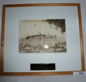
Print, Orcades to the Sea by Peter Jones, 1942_10
RMS Orcades was a British built ocean liner that served on the UK-Australia route as a Royal Mail Ship from 1937-1939. Orcades was requisitioned by the British government as a troopship in 1939. It was torpedoed and sunk in October 1942 with the loss of 48 lives. The next Orcades was the first new purpose-built vessel to enter the Australian migrant trade after the Second World War and made over 55 voyages to Australia between 1948 and 1972.The significance of this painting is that it was presented as a commemoration of the 50th anniversary of the end of the second world war by the Scullin Australia Remembers Committee in 1995.Framed and signed print of ship "Orcades". Print measures 22 x 30 cm. Print is signed "Peter Jones '95".On back of frame "No.9 Orcades to Asia Peter Jones". orcades, world war ii, scullin australia remembers committee, prints, peter jones -
 Australian National Surfing Museum
DVD Movie, Morning Of The Earth, Circa 2003
Morning Of The Earth tells the fantasy of three exotic lands: Bali, Hawaii and Australia, where surfers made their own houses, surfboards and lived in harmony with nature. Featuring Nat Young, Terry Fitzgerald, Gerry Lopez, Stephen Cooney, David Treloar and Michael Petersen. The movie soundtrack featured Terry Hannigan, Taman Shud, Brian Cadd , G. Wayne Thomas and many others. The film premiered at the Manly Silver Screen Theatre in 1972.Described by many as the greatest surf film ever made in Australia and one of the most influential surf films ever made, Albert Falzon's stunning surf footage captured the spirit of a timeless period in Australian surf history.Black text on red with iconic black and white photograph of Michael Petersen cutback.Film title, Jonas Mekas quote.nat young, gerry lopez, albert falzon, michael petersen, taman shud, morning of the earth, terry fitzgerald, stephen cooney, david treloar, bali, brian cadd, terry hannigan, g wayne thomas, david elfick -
 Glen Eira Historical Society
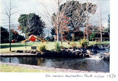
Article - HARLESTON PARK, ELSTERNWICK
This file contains 2 items, viz: 1/Press cutting from the Melbourne Herald (01/06/1974) regarding opposition by some Elsternwick residents to plans by Caulfield Council to install gas barbecues in Harleston Park. 2/Five coloured photographs of the park i.e three glossy prints: on verso of one ‘Harleston Park circa 1972’ and on the others ‘Harleston Park’; two matt prints, on verso of each, ‘Harleston Park, 1982’.harleston park, ross albert, ross mrs albert, brodie william, meldrum frank, wilson kerry, allison road, seymour road, parks and reserves, newspapers, barbecues -
 Sunshine and District Historical Society Incorporated
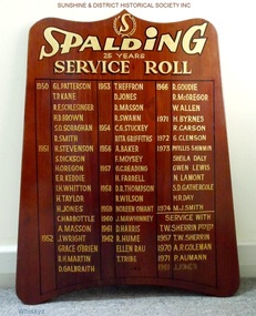
Honour Board, SPALDING 25 Years Service Roll
The Spalding factory was located at the intersection of Ballarat Rd and McIntyre Rd in Sunshine (North East corner). The factory made sporting goods, and in 1972 Spalding acquired T. W. Sherrin Pty Ltd which was a major manufacturer of footballs used in Australian Rules football games. In the early 1990's the factory in Sunshine was demolished and replaced by the first Bunnings Hardware store to be erected in Victoria. In July 2003 Spalding was bought out by the Russell Corporation.The board is a historical record of the loyal employees who provided at least 25 years of service to Spalding or to T. W. Sherrin Pty Ltd.Brown stained wooden board with wave shaped top which is about 14 cm less wide than the base. The names of employees who have provided 25 years of loyal service are recorded on the board in gold coloured lettering. The board contains the names of 50 workers who had reached the 25 year service milestone at SPALDING, and also the names of 4 employees who did the same at T. W. SHERRIN Pty Ltd. The first people reached this milestone in 1950 and the last person is recorded as reaching this in 1981.honour board, spalding, t. w. sherrin pty ltd, 25 years service roll -
 Unions Ballarat
The Whitlam Venture (Don Woodward Collection), Reid, Alan, 1985
Gough Whitlam was the ALP Prime Minister of Australia from 1972-1975. It was the first ALP government since Ben Chifley's government was defeated in 1951. The book is an historical account of the Whitlam government years. Whitlam was dismissed, in controversial circumstances, by the governor general (Sir John Kerr) and Malcolm Fraser (Liberal Opposition Leader) was appointed as caretaker Prime Minister.. This was an unprecedented action. A federal election followed soon after in which the Whitlam government was defeated. Federal political history.Book; 536 pages. Dustjacket: green background; black and white picture of Gough Whitlam with microphone; white lettering; author's name and title. Cover: green background; gold lettering; author's name and title.btlc, ballarat trades hall, ballarat trades and labour council, prime minister - australia - gough whitlam, politics, governor general, kerr, sir john, constitution - australia, parliament - australia, alp, australian labor party, liberal party australia, fraser, malcolm, leader of the opposition -
 Mt Dandenong & District Historical Society Inc.
Photograph, View Over Roof of "Kalorama"
Taken in 1908, this photograph, though rather blurry, gives an indication of the location of the early settler properties in the valley in relation to one another. European trees have been planted at 'Kalorama' , the first home of Ellis Jeeves. John Lundy-Clarke grew up in the Kalorama/Mt Dandenong area and later in life (1972-74) began to write a comprehensive history of the area working from an original settlement map in an effort to cover all areas.Black and white photograph looking across hillside with large trees and rooftops visible. Handwritten description on reverse by John Lundy-Clarke.1908 View over roof of “Kalorama” towards the Falls. Paynter’s house on LOT 29 in low centre (now “Yosemite”). Pimms house on LOT 19 above Paynters and beyond scrub. Logan’s house faint above left of “Kalorama”. Dunbar’s LOT 20 beyond Pimm’s orchard. Gum trees on right were on Price’s LOT 19 now Tosari Rd area. It was one of these that figured in the episode of the runaway log in 1930. It leaped in one bound over Barbers Road at bottom of scrub in centre of picture then over Logan’s house.kalorama, ellis jeeves, jeeves -
 Mt Dandenong & District Historical Society Inc.
Photograph, Harmony Vale 1933
John Lundy-Clarke grew up in the Kalorama/Mt Dandenong area and later in life (1972-74) began to write a comprehensive history of the area working from an original settlement map in an effort to cover all areas. Harmony Vale was the name of the homestead built by early pioneer Jabez Richardson. The whole of the valley took on this name. The building lasted until 1933. The Silvan Dam was completed in 1932 and was full when this photograph was taken.Black and white photograph looking down over a forested area with a dam in the background. Copied from a Rose Series postcard c1933. Handwritten inscription on reverse by John Lundy-ClarkeRose Series photo of 1933 showing “Harmony Vale” still standing. Copied 1973 JLCharmony vale, silvan dam, jabez richardson -
 Mt Dandenong & District Historical Society Inc.
Photograph, View From Doughty's Road 1913
Mt Calvin, the homestead of Jeanie and Willie Richardson can be clearly seen in the clearing above the men in the picture. The white roof of the Barber homestead is on the right of the picture. A landslide in 1934 destroyed the tree ferned area. John Lundy-Clarke grew up in the Kalorama/Mt Dandenong area and later in life (1972-74) began to write a comprehensive history of the area working from an original settlement map in an effort to cover all areas.Black and white photograph that is a copy of a Rose series postcard titled 'The Picturesque Road to Mt. Dandenong. Vic.' It shows two men (probably Rose Series employees), one sitting and one standing at the edge of an unmade road. Large tree ferns line the roadside. Handwritten inscription on reverse by John Lundy-Clarke1913 View east from Doughty’s Road showing Jeannie Richardson’s home through the gap in the trees. A little to the right of and below centre of picture can be seen George Barber’s home with Barbers Road turning around the wagon shed that was a little up the hill from the house. The tree ferns in the picture were destroyed in the landslide of 1934. In the distance at the right can be seen F.M. Childs Homestead complex with the Richardson paddocks beyond it.mt calvin, jeanie richardson, willie richardson, george barber, landslide, tree fern