Showing 7652 items
matching post office.
-
 Bacchus Marsh & District Historical Society
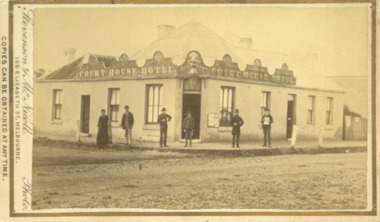
Photograph, Court House Hotel Main Street Bacchus Marsh 1883
... by sending the Name and Post Office Money Order or Stamps... at any time by sending the Name and Post Office Money Order ...This building on the corner of Court House Place and Main Street Bacchus Marsh was a licensed hotel since 1864. Prior to 1864 the building was in use as a saddlery business, established by Joseph Purday and Alfred Smith. In 1864, Purday and Alfred Tanner converted the shop to a hotel. Tanner, followed by his wife Ann, were licensees until 1892. The hotel signage above the door features the Prince of Wales feathers, an acknowledgement of the Prince of Wales Volunteer Light Horse Werribee unit which used the hotel for their meetings. In 1911 the single-storey hotel was demolished and a two-storey brick hotel was built. The identities of the five men and one woman in the photo are not known. The woman at the left of the group is possibly Ann Tanner who was the licensee around the time this photograph was taken. Small sepia unframed photograph on card with gold border framing photograph. Housed in the album, 'Photographs of Bacchus Marsh and District in 1883 by Stevenson and McNicoll'. A group of five men and one woman can be seen standing in front of the Court House Hotel building, Main Street Bacchus Marsh. A large ornate sign around the roofline bears the words “Courthouse Hotel”. Above the door a sign featuring the Prince of Wales feathers also has the name “Ann Tanner.” One of the men is displaying a document which apparently is of some importance, now lost.On the front: Stevenson & McNicoll. Photo. 108 Elizabeth St. Melbourne. COPIES CAN BE OBTAINED AT ANY TIME. On the back: LIGHT & TRUTH inscribed on a banner surmounted by a representation of the rising sun. Copies of this Portrait can be had at any time by sending the Name and Post Office Money Order or Stamps for the amount of order to STEVENSON & McNICOLL LATE BENSON & STEVENSON, Photographers. 108 Elizabeth Street, MELBOURNE. stevenson and mcnicoll 1883 photographs of bacchus marsh and district, hotels bacchus marsh, court house hotel bacchus marsh -
 Bacchus Marsh & District Historical Society
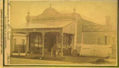
Photograph, Pearce Brothers Store Main Street Bacchus Marsh 1883
... by sending the Name and Post Office Money Order or Stamps... at any time by sending the Name and Post Office Money Order ...This store was built in 1881 and opened as a branch of Pearce Brothers main store which was further along in Main Street, Bacchus Marsh. The store in this image opened around early June 1881 and was described in the Bacchus Marsh Express as "quite above the usual standard of stores in towns of a similar or even much larger size. The building is most substantially built of brick, and measures 58 feet by 26 feet, with walls fourteen feet high inside. The interior is most elaborately fitted with shelves and glass cases covering both side walls and two ends formed by small offices separated from the main store by glass and wood panelled partitions, with a passage way between to the storeroom at the rear", Express, (Bacchus Marsh, 11 June, 1881, page 2). The building was designed by one of its proprietors T. G. Pearce and was entirely constructed by local contractors and workers.Small sepia unframed photograph on card with gold border framing photograph. Housed in the album, 'Photographs of Bacchus Marsh and District in 1883 by Stevenson and McNicoll'. The image depicts a general store with a double-front of windows. Goods such as spades, shovels, tubs and wringers are arrayed on the footpath in front of the store. At the front of the shop under a verandah stands a man, possibly one of the Pearce brothers who owned this business. Next to the store is a vacant block of land with a white picket fence. A sign erected above the fence advertises: “ Pearce Bros. Chaff. Hay & Oats. Produce. Dealer. “On the front: Stevenson & McNicoll. Photo. 108 Elizabeth St. Melbourne. COPIES CAN BE OBTAINED AT ANY TIME. On the back: LIGHT & TRUTH inscribed on a banner surmounted by a representation of the rising sun. Copies of this Portrait can be had at any time by sending the Name and Post Office Money Order or Stamps for the amount of order to STEVENSON & McNICOLL LATE BENSON & STEVENSON, Photographers. 108 Elizabeth Street, MELBOURNE. pearce family bacchus marsh, general stores bacchus marsh, shops bacchus marsh, pearce brothers general store bacchus marsh, stevenson and mcnicoll 1883 photographs of bacchus marsh and district -
 Bacchus Marsh & District Historical Society
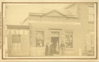
Photograph, Shop next to Royal Hotel Main Street Bacchus Marsh 1883
... by sending the Name and Post Office Money Order or Stamps... at any time by sending the Name and Post Office Money Order ...The building in this image was built by J. I. Murray for use as a Bank premises. The National Bank of Australasia opened a branch in the building in 1862 and remained there until 1865. The Colonial Bank of Australasia then occupied the building from 1865 until 1872. At the time this image was taken in 1883 the building was in use as a shop, although a sign saying 'National Bank of Australasia' could still be seen on the building. Goods for sale can clearly be seen in the windows and the photographers’ wagon or cart can be partly seen to the right of the picture. At a later stage the building became part of the Royal Hotel which can be seen to the right of the building. The small building to the left of the picture was used as a printing office by the West Bourke and South Grant Guardian newspaper between 1865 and 1872.Small sepia unframed photograph on card with gold border framing photograph. Housed in the album, 'Photographs of Bacchus Marsh and District in 1883 by Stevenson and McNicoll'. The image shows a shop in Main Street Bacchus Marsh in 1883. Goods for sale can be seen in the windows but there is no signage on the building to indicate what type of shop it is. A sign across the upper facade reads 'National Bank of Australasia' but this bank had vacated this location by 1865. Three women and a man can be seen standing in front of the shop. Two of the women appear to be shaking hands. The woman standing in the doorway is wearing an apron and may be the shop owner or assistant. Just visible at the edge of the photo can be seen a buggy with advertisements on the back and side. Letters that can be distinguished suggest that in all probability this is the carriage used by Stevenson and McNicoll, Photographers, on their trips around rural towns and countryside. On the front: Stevenson & McNicoll. Photo. 108 Elizabeth St. Melbourne. COPIES CAN BE OBTAINED AT ANY TIME. On the back: LIGHT & TRUTH inscribed on a banner surmounted by a representation of the rising sun. Copies of this Portrait can be had at any time by sending the Name and Post Office Money Order or Stamps for the amount of order to STEVENSON & McNICOLL LATE BENSON & STEVENSON, Photographers. 108 Elizabeth Street, MELBOURNE. stevenson and mcnicoll 1883 photographs of bacchus marsh and district, shops bacchus marsh vic., banks bacchus marsh vic., commercial vehicles -
 Bacchus Marsh & District Historical Society
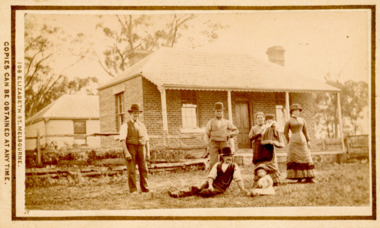
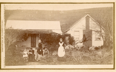
Photograph, Tom Oliver and family at Woodside, Parwan 1883
... by sending the Name and Post Office Money Order or Stamps... the Name and Post Office Money Order or Stamps for the amount ...The family in this photograph is believed to be the Oliver family. Thomas Oliver, a farmer, advocated for a school at Parwan near Bacchus Marsh. This image depicts him and members of his family at his property, Woodside in 1883. The Woodside property was formerly owned by John Cook. The Olivers lived at Woodside during the 1870s and 1880s. Thomas Oliver retired around 1888 and moved to 'Elam's Cottage' in Bacchus Marsh. Three months after moving to Bacchus Marsh he died.Small sepia unframed photograph on card with gold border framing photograph. Housed in the album, 'Photographs of Bacchus Marsh and District in 1883 by Stevenson and McNicoll'. An image depicting a family group in front of a farm house. There are three men, two women and two small children standing or lying on a grassed area in front of the house, which has a post-and-rail fence. The farmhouse is a simple rectangular- shaped brick house with two chimneys and a tiled or slate roof. Behind the house can be seen a second building, also one-storeyed with a tiled or slate hip roof. On the front: Stevenson & McNicoll. Photo. 108 Elizabeth St. Melbourne. COPIES CAN BE OBTAINED AT ANY TIME. On the back: LIGHT & TRUTH inscribed on a banner surmounted by a representation of the rising sun. Copies of this Portrait can be had at any time by sending the Name and Post Office Money Order or Stamps for the amount of order to STEVENSON & McNICOLL LATE BENSON & STEVENSON, Photographers. 108 Elizabeth Street, MELBOURNE. stevenson and mcnicoll 1883 photographs of bacchus marsh and district, farms, farmers, oliver family parwan vic. -
 Bacchus Marsh & District Historical Society
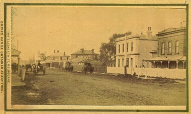
Photograph, Main Street Bacchus Marsh 1883 looking east
... by sending the Name and Post Office Money Order or Stamps... of this Portrait can be had at any time by sending the Name and Post Office ...View of Main Street Bacchus Marsh 1883, showing early notable buildings on the southern side of the street, including the Courthouse, National Bank of Australasia, Border Inn, Hall of Commerce building. Small sepia unframed photograph on card with gold border framing photograph. Housed in the album, 'Photographs of Bacchus Marsh and District in 1883 by Stevenson and McNicoll'. Several horse-drawn vehicles can be seen travelling along an unmade road. Piles of excavated dirt can be seen along the side of the road. Four substantial two-storeyed buildings can be seen along the southern side of the street.On the front: Stevenson & McNicoll. Photo. 108 Elizabeth St. Melbourne. COPIES CAN BE OBTAINED AT ANY TIME. On the back: LIGHT & TRUTH inscribed on a banner surmounted by a representation of the rising sun. Copies of this Portrait can be had at any time by sending the Name and Post Office Money Order or Stamps for the amount of order to STEVENSON & McNICOLL LATE BENSON & STEVENSON, Photographers. 108 Elizabeth Street, MELBOURNE. stevenson and mcnicoll 1883 photographs of bacchus marsh and district, bacchus marsh roads and streets, bacchus marsh main street 19th century -
 Bacchus Marsh & District Historical Society
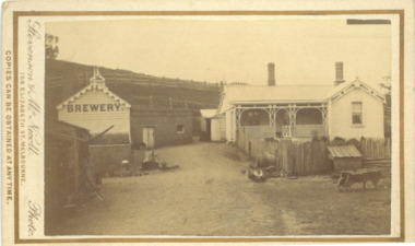
Photograph, Symington Brewery, Hopetoun, near Bacchus Marsh 1883
... by sending the Name and Post Office Money Order or Stamps... the Name and Post Office Money Order or Stamps for the amount ...The family of William Symington arrived in Melbourne in 1855. By 1858 they had come to Bacchus Marsh and built a house at Hopetoun a few kilometres east of the town. A brewery next to the house was also built around this time. It was a licensed brewery between 1862 and 1886. The elder William Symington died in March 1867 and the brewery was then operated by his son the younger William Symington for a number of years. It ceased operations sometime before 1900. Small sepia unframed photograph on card with gold border framing photograph. Housed in the album, 'Photographs of Bacchus Marsh and District in 1883 by Stevenson and McNicoll'. The image shows the brewery and house which belonged to the Symington family of Hopetoun, near Bacchus Marsh. The house is a timber structure with two chimneys and a front verandah. The front yard of the house is enclosed by a timber fence. At the front of the fence can be seen a dog kennel. Other tools, such as a wheelbarrow, lie in the yard. The brewery building is of timber and brick. On the hillside behind the buildings are paddocks fenced with post-and -rail fencing.On the front: Stevenson & McNicoll. Photo. 108 Elizabeth St. Melbourne. COPIES CAN BE OBTAINED AT ANY TIME. On the back: LIGHT & TRUTH inscribed on a banner surmounted by a representation of the rising sun. Copies of this Portrait can be had at any time by sending the Name and Post Office Money Order or Stamps for the amount of order to STEVENSON & McNICOLL LATE BENSON & STEVENSON, Photographers. 108 Elizabeth Street, MELBOURNE. stevenson and mcnicoll 1883 photographs of bacchus marsh and district, breweries, symington family bacchus marsh, william symington 1840-1929, william symington 1802-1867 -
 Bacchus Marsh & District Historical Society
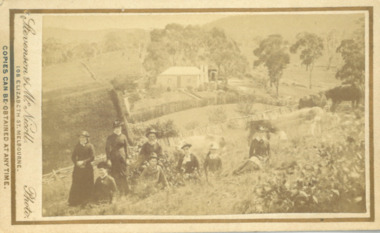
Photograph, Cameron family at Glen Head property near Bacchus Marsh 1883
... by sending the Name and Post Office Money Order or Stamps... of this Portrait can be had at any time by sending the Name and Post Office ...Malcolm Cameron, came from Scotland to Australia with his wife in 1862. From late 1862 they lived in Bacchus Marsh and remained there for the rest of their lives. After working as a shepherd for sometime Malcolm Cameron was able to acquire land for a farm a few kilometers north west of Bacchus Marsh. The farm was called Glen View but this was later changed to Grand View. It is known to have been a wheat farm, Malcolm Cameron died aged 89 in 1922. His wife died in 1926. Small sepia unframed photograph on card with gold border framing photograph. Housed in the album, 'Photographs of Bacchus Marsh and District in 1883 by Stevenson and McNicoll'. The image shows a family group, the Cameron family of Bacchus Marsh, standing and sitting in a paddock on their farm. Cows graze in the paddock nearby. In the background, in the distance, can be seen the Cameron family home.On the front: Stevenson & McNicoll. Photo. 108 Elizabeth St. Melbourne. COPIES CAN BE OBTAINED AT ANY TIME. On the back: LIGHT & TRUTH inscribed on a banner surmounted by a representation of the rising sun. Copies of this Portrait can be had at any time by sending the Name and Post Office Money Order or Stamps for the amount of order to STEVENSON & McNICOLL LATE BENSON & STEVENSON, Photographers. 108 Elizabeth Street, MELBOURNE. stevenson and mcnicoll 1883 photographs of bacchus marsh and district, farmers, farms, wheat farms, cameron family bacchus marsh -
 Bacchus Marsh & District Historical Society
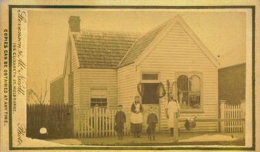
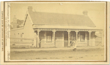
Photograph, Cottage Stamford Hill Bacchus Marsh 1883
... by sending the Name and Post Office Money Order or Stamps... at any time by sending the Name and Post Office Money Order ...Stamford Hill is on the western side of Bacchus Marsh. Main Street which runs in an East to West direction through the town runs directly up Stamford Hill. The precise location of the house or cottage in this image has not been identified and it appears to have been demolished. The identities of the two women and one girl in the picture are unknown.Small sepia unframed photograph on card with gold border framing photograph. Housed in the album, 'Photographs of Bacchus Marsh and District in 1883 by Stevenson and McNicoll'. The image shows a frontal view of a cottage. The cottage is behind a high timber fence but most of the cottage can be seen. Two young women are standing in front of the fence facing the camera. Standing between them is a young girl. A dog sits beside one of the women. Another dog stands in the gateway behind the girl.On the front: Stevenson & McNicoll. Photo. 108 Elizabeth St. Melbourne. COPIES CAN BE OBTAINED AT ANY TIME. On the back: LIGHT & TRUTH inscribed on a banner surmounted by a representation of the rising sun. Copies of this Portrait can be had at any time by sending the Name and Post Office Money Order or Stamps for the amount of order to STEVENSON & McNICOLL LATE BENSON & STEVENSON, Photographers. 108 Elizabeth Street, MELBOURNE stevenson and mcnicoll 1883 photographs of bacchus marsh and district, houses bacchus marsh -
 Bacchus Marsh & District Historical Society
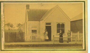
Photograph, Group of women at a farmhouse near Bacchus Marsh 1883
... by sending the Name and Post Office Money Order or Stamps... at any time by sending the Name and Post Office Money Order ...This image is one of several family group portraits taken by Stevenson and McNicoll on rural properties. This property has been identified as that of John Tilley at Parwan’s Creek. The people depicted are presumably members of the Tilley family. The dwelling has since been demolished. Tilleys Road in Maddingley is probably named for this family farm.Small sepia unframed photograph on card with gold border framing photograph. Housed in the Jeremeas Family Album which contains photographs of Bacchus Marsh and District in 1883 by Stevenson and McNicoll. The property has been identified as that of John Tilley at Parwan’s Creek. This property has since been demolished. Presumably, the photo is of members of the Tilley family. The image shows a family group of four women and one young child. It is unclear if the child is a boy or a girl, due to the custom of clothing young male children in dresses. The women are sitting or standing in two groups. To the right stands an older woman in a starched white apron, perhaps indicating that she is the housekeeper. The group on the left is of one woman standing and two women seated, one reading a newspaper or magazine. The young child reaches out one arm to her, perhaps for reassurance. The dwelling consists of two structures, one single storeyed cottage, which is perhaps the older part, and an adjoining weatherboard house with a steeply pitched roof and a prominent chimney at the front. The cottage has a shingled verandah partially covered by corrugated iron, which also covers the roof. Trees, a climbing vine and shrubs form a rather unkempt garden. On the hill rising behind the farmhouse there can be seen animals, possibly sheep, grazing.On the front: Stevenson & McNicoll. Photo. 108 Elizabeth St. Melbourne. COPIES CAN BE OBTAINED AT ANY TIME. On the back: LIGHT & TRUTH inscribed on a banner surmounted by a representation of the rising sun. Copies of this Portrait can be had at any time by sending the Name and Post Office Money Order or Stamps for the amount of order to STEVENSON & McNICOLL LATE BENSON & STEVENSON, Photographers. 108 Elizabeth Street, MELBOURNE. stevenson and mcnicoll 1883 photographs of bacchus marsh and district, farmhouses, families, women bacchus marsh -
 Bacchus Marsh & District Historical Society
Photograph, James Reid House Bacchus Marsh 1883
... by sending the Name and Post Office Money Order or Stamps... of this Portrait can be had at any time by sending the Name and Post Office ...James Reid was born in Scotland near Glasgow and came to Victoria as a young man in 1854. Shortly after arriving he came to Bacchus Marsh where he lived until his death in 1902 at the age of 74 years. For most of these years he conducted a wheelwrights and coach builders business in Bacchus Marsh. In the nineteenth and early twentieth centuries, wheelwrights and blacksmiths played an essential role in the functioning of the whole community. Before the industrialisation of manufacturing, wheels and other components of vehicles for transport, all metal objects, including farm implements, building requirements and domestic utensils were made by hand. As mechanisation of industry increased, the smith commonly performed the role of farrier in the times when horse power was pivotal to all aspects of society. Small sepia unframed photograph on card with gold border framing photograph. Housed in the album, 'Photographs of Bacchus Marsh and District in 1883 by Stevenson and McNicoll' The photo shows a plain brick house with a central front door with a window on either side. There are a further two windows along the side of the house. On the left-hand side of the building there is a smaller room with its own entry door. The main roof is tiled with shingles or slate and features two substantial chimneys. At the front of the house stands a young woman with her hands clasped. A horse can be seen at the rear of the house. From the photo of the James Reid Wheelwright and Blacksmith Shop, Victorian Collections No.VC 618, we know that this house stood to the rear of the workshop. The wheel tracks which can be seen lead out to Main Street. On the front: Stevenson & McNicoll. Photo. 108 Elizabeth St. Melbourne. COPIES CAN BE OBTAINED AT ANY TIME. On the back: LIGHT & TRUTH inscribed on a banner surmounted by a representation of the rising sun. Copies of this Portrait can be had at any time by sending the Name and Post Office Money Order or Stamps for the amount of order to STEVENSON & McNICOLL LATE BENSON & STEVENSON, Photographers. 108 Elizabeth Street, MELBOURNE houses bacchus marsh, stevenson and mcnicoll 1883 photographs of bacchus marsh and district, james reid 1828?-1902, wheelrights bacchus marsh -
 Bacchus Marsh & District Historical Society
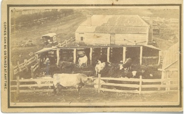
Photograph, Dairy Farm Bacchus Marsh District 1883
... by sending the Name and Post Office Money Order or Stamps... of this Portrait can be had at any time by sending the Name and Post Office ...The number of cattle in this photo suggests that it was a small holding, at the beginning of the dairy industry in Bacchus Marsh. This industry became a major source of employment in Bacchus Marsh. By the early twentieth century, the Bacchus Marsh region was a significant contributor to the dairy industry in Australia. Small sepia unframed photograph on card with gold border framing photograph. Housed in the album, 'Photographs of Bacchus Marsh and District in 1883 by Stevenson and McNicoll'. This is a photo of a dairy farm in an unknown location in the Bacchus Marsh district. It has been taken from an elevation looking down at the farm. On the left, the roadside can be seen running alongside a stream or river which is fenced off by a line of trees and a post and rail fence. Parked on the road outside the farmhouse is a wagon which is unhitched. The wagon has a white rooftop and on the side can be seen a professional logo, details unclear. This wagon is most likely the wagon used by the photographers to access outlying properties with their photographic equipment. The farmhouse itself faces the road with side doors giving onto the yard. The roof is partially covered by new slates, possibly slate covering bark. Six milking sheds of post-and-rail construction adjoin the farm yard. In the first and fourth stalls (l to r) the farmer and his wife can be seen seated, miking cows. The rest of the herd are awaiting milking in the yard which also has a post-and-rail fence. A bull of milking shorthorn breed stands outside the fence. The milking herd itself is of various breeds; Herefords, roan shorthorn and roan and white shorthorns can be identified. On the right is a shed of rough-hewn boards and a shingle roof. In the yard at the back of the house stands a cart or dray. On the front: Stevenson & McNicoll. Photo. 108 Elizabeth St. Melbourne. COPIES CAN BE OBTAINED AT ANY TIME. On the back: LIGHT & TRUTH inscribed on a banner surmounted by a representation of the rising sun. Copies of this Portrait can be had at any time by sending the Name and Post Office Money Order or Stamps for the amount of order to STEVENSON & McNICOLL LATE BENSON & STEVENSON, Photographers. 108 Elizabeth Street, MELBOURNE. dairy farms, stevenson and mcnicoll 1883 photographs of bacchus marsh and district -
 Bacchus Marsh & District Historical Society
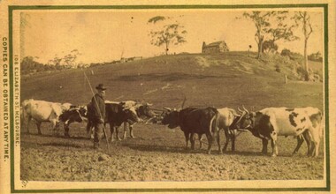
Photograph, Bullocks in paddock, near Bacchus Marsh 1883
... by sending the Name and Post Office Money Order or Stamps... of this Portrait can be had at any time by sending the Name and Post Office ...Transportation of goods and material by bullock teams was a common feature of life in nineteenth century Australia. Bullock teams could comprise more than twenty bullocks to haul very large and heavy loads. They were the equivalent of large trucks on the roads of today. Many Australian country towns have very wide main streets to allow for large bullock teams to turn without having to unharness and reharness the animals. The bullock driver in this photo is thought to be of James Densley, aka Charlie (the ) Carter, who lived at Hopetoun, east of the township of Bacchus Marsh. He worked as a carrier with a bullock team in the later years of the nineteenth century. He had a reputation as a sober man who never used bad language. (Williams, W. A History of Bacchus Marsh and its Pioneers. 1836-1936. Reproduced 2015 BMDHS.p. 78.) James Densley died in 1905, supposed to be over the age of ninety.Small sepia unframed photograph on card with gold border framing photograph. Housed in the album, 'Photographs of Bacchus Marsh and District in 1883 by Stevenson and McNicoll'. The image shows a group of seven shorthorn bullocks in a paddock. Their yokes and a chain can be seen. Standing near them is a bearded man holding a bullock team leader's whip. He is dressed neatly and is wearing a very smart hat. On the hilltop stands a large hut, possibly with a bark shingle roof. A chimney is at the end of the dwelling. On the front: Stevenson & McNicoll. Photo. 108 Elizabeth St. Melbourne. COPIES CAN BE OBTAINED AT ANY TIME. On the back: LIGHT & TRUTH inscribed on a banner surmounted by a representation of the rising sun. Copies of this Portrait can be had at any time by sending the Name and Post Office Money Order or Stamps for the amount of order to STEVENSON & McNICOLL LATE BENSON & STEVENSON, Photographers. 108 Elizabeth Street, MELBOURNE. stevenson and mcnicoll 1883 photographs of bacchus marsh and district, bullocks, bullock teams -
 Bacchus Marsh & District Historical Society
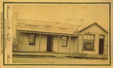
Photograph, Harvest Home Hotel Main Street Bacchus Marsh 1883
... by sending the Name and Post Office Money Order or Stamps... of this Portrait can be had at any time by sending the Name and Post Office ...The Harvest Home Hotel was licensed as a beer shop in 1866. Patrick Vallence was the licensee. On his death in 1874 his widow Mrs M. A. Vallence obtained the license. At the time this image was taken George Marshall was leasing the hotel. Following a decrease in the population of Bacchus Marsh, by 1911 the hotel had lost its licence.The Vallence family still owned the building after the loss of the hotel licence in 1911and it was used for some years after this as a private residence by some members of the Vallence family. Small sepia unframed photograph on card with gold border framing photograph. Housed in the album, 'Photographs of Bacchus Marsh and District in 1883 by Stevenson and McNicoll', the Jeremeas Family Album. The image depicts the Harvest Home Hotel situated in Main Street Bacchus Marsh. The name of the hotel can be seen above the verandah roof. The building appears to be of stone with decorative stonework corners. A verandah is inset to the left of a gabled front section which has its own door and window. On either side of the door beneath the verandah can be seen boot or shoe scrapers. A deep gutter runs along the front of the hotel, with a slab acting as a bridge to the road. Situated in the gutter at the front of the hotel is a water trough which has an arch above it with an ornate lantern, probably to light the front entry and to enable horses to be watered at night. A hitching post is nearby.On the front: Stevenson & McNicoll. Photo. 108 Elizabeth St. Melbourne. COPIES CAN BE OBTAINED AT ANY TIME. On the back: LIGHT & TRUTH inscribed on a banner surmounted by a representation of the rising sun. Copies of this Portrait can be had at any time by sending the Name and Post Office Money Order or Stamps for the amount of order to STEVENSON & McNICOLL LATE BENSON & STEVENSON, Photographers. 108 Elizabeth Street, MELBOURNE. hotels bacchus marsh, stevenson and mcnicoll 1883 photographs of bacchus marsh and district, vallence family bacchus marsh, harvest home hotel bacchus marsh -
 Bacchus Marsh & District Historical Society
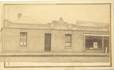
Photograph, William Watts Boot and Shoemaker Shop Main Street Bacchus Marsh 1883
... by sending the Name and Post Office Money Order or Stamps... of this Portrait can be had at any time by sending the Name and Post Office ...William Watts arrived in Bacchus Marsh in 1862 and for many years conducted a boot and shoe makers business in Main Street. This building, known as ‘Kentbury’ was built about 1858, and was formerly the premises of Bastings, cordwainer. The premises were enlarged in 1876 and occupied by Weaver. The building was demolished c.1960. Small sepia unframed photograph on card with gold border framing photograph. Housed in the album, 'Photographs of Bacchus Marsh and District in 1883 by Stevenson and McNicoll'. The image depicts the frontage of a boot and shoe makers premises.Signage on the upper part of the building reads 'Boot and Shoe Maker - Importer - Watts - Leather - Grindery'. The left hand side of the building appears to be a domestic dwelling, with a central door and two windows, one on either side. To the right there is a large shop display window and door. Both doors open directly onto the footpath. A post, probably a hitching post, stands on the footpath.On the front: Stevenson & McNicoll. Photo. 108 Elizabeth St. Melbourne. COPIES CAN BE OBTAINED AT ANY TIME. On the back: LIGHT & TRUTH inscribed on a banner surmounted by a representation of the rising sun. Copies of this Portrait can be had at any time by sending the Name and Post Office Money Order or Stamps for the amount of order to STEVENSON & McNICOLL LATE BENSON & STEVENSON, Photographers. 108 Elizabeth Street, MELBOURNE. stevenson and mcnicoll 1883 photographs of bacchus marsh and district, boot makers, shoe shops -
 Bacchus Marsh & District Historical Society
Photograph, Thomas Heath's Saddlery Main Street Bacchus Marsh 1883 Image 1
... by sending the Name and Post Office Money Order or Stamps... at any time by sending the Name and Post Office Money Order ...Thomas Heath built this shop for his saddlery business around 1875. In 1926 after 58 years operating his saddlery in Bacchus Marsh he retired and the assets of his business were sold in a clearing sale. The building was later demolished. Apart from his services in saddlery his premises was known to be a gathering place for much discussion. Heath was known to openly express his political opinions and his saddlery premises was known by many in the community as the 'Parliament'.Small sepia unframed photograph on card with gold border framing photograph. Housed in the album, 'Photographs of Bacchus Marsh and District in 1883 by Stevenson and McNicoll'. The photo is of a double-fronted weatherboard building with a shingle roof. The front gabled section stands directly on street level and is flanked by a picket fence. The door and overhead window and the side window with arched panels may indicate that this was the shop section, with a dwelling to the rear. Items which may be for sale can be seen hanging in the windows. The recessed side section of the building with a twelve-sectioned window, chimney and a back extension was probably the dwelling used by the family. On the footpath stands the saddler with three children, two boys and an older girl, probably Mr Thomas Heath and three of his five children. A hitching rail runs along the front of the workshop. Indicating the type of business Mr Heath ran, are a saddle placed over the rail and two horse collars and reins hanging either side of the workshop door. On the front: Stevenson & McNicoll. Photo. 108 Elizabeth St. Melbourne. COPIES CAN BE OBTAINED AT ANY TIME. On the back: LIGHT & TRUTH inscribed on a banner surmounted by a representation of the rising sun. Copies of this Portrait can be had at any time by sending the Name and Post Office Money Order or Stamps for the amount of order to STEVENSON & McNICOLL LATE BENSON & STEVENSON, Photographers. 108 Elizabeth Street, MELBOURNE. saddleries, saddlers, thomas heath 1842-1930 saddler -
 Bacchus Marsh & District Historical Society
Photograph, Cameron family at Glen Head farm house near Bacchus Marsh 1883
... by sending the Name and Post Office Money Order or Stamps... of this Portrait can be had at any time by sending the Name and Post Office ...Malcolm Cameron, came from Scotland to Australia with his wife Isabella in 1862. From late 1862 they lived in Bacchus Marsh and remained there for the rest of their lives. After working as a shepherd for some time, Malcolm Cameron was able to acquire land for a farm a few kilometres north west of Bacchus Marsh. The farm was called Glen View but this was later changed to Grand View. It is known to have been a wheat farm. Malcolm Cameron died aged 89 in 1922. His wife died in 1926. Mrs Cameron is presumed to be the woman seated in the photograph and the younger people the Cameron children, Catherine (b.1863), Marion (b.1864)), Mary (b.1867), John (b.1870) and Isabella (b.1872). Small sepia unframed photograph on card with gold border framing photograph. Housed in the album, 'Photographs of Bacchus Marsh and District in 1883 by Stevenson and McNicoll'. The image shows a family group, the Cameron family of Bacchus Marsh, standing and sitting in the garden in front of their farm house. The group comprises four women, a girl, a boy and an elderly man, who is presumed to be Malcolm Cameron. The woman seated in the middle of the group is likely to be Mrs.Cameron. To the left in the picture is a dog. In the background is the weatherboard farm house, a simple construction with two large chimneys and a skillion extension.On the front: Stevenson & McNicoll. Photo. 108 Elizabeth St. Melbourne. COPIES CAN BE OBTAINED AT ANY TIME. On the back: LIGHT & TRUTH inscribed on a banner surmounted by a representation of the rising sun. Copies of this Portrait can be had at any time by sending the Name and Post Office Money Order or Stamps for the amount of order to STEVENSON & McNICOLL LATE BENSON & STEVENSON, Photographers. 108 Elizabeth Street, MELBOURNE. stevenson and mcnicoll 1883 photographs of bacchus marsh and district, farmers, farms, wheat farms, cameron family bacchus marsh -
 Bacchus Marsh & District Historical Society
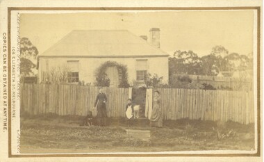
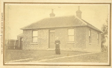
Photograph, House of Christopher Crisp Bacchus Marsh 1883
... by sending the Name and Post Office Money Order or Stamps... at any time by sending the Name and Post Office Money Order ...The former Christopher Crisp residence was constructed in 1868 by William Watson, one of the members of the Bacchus Marsh Express printing company which took over the management of The Express after the first edition, 7 July 1866, was published by its founder, George Lane, a book binder. This syndicate failed after three months and the ownership was then taken over by Christopher Crisp, a compositor working for the company. Crisp remained the editor from 1866 to his death in 1915, when he was succeeded by his son, also called Christopher Crisp, and later by his grandson. Under the Crisp family leadership, The Express widened its readership and was subscribed to by influential men and public servants in Melbourne. (Heritage Victoria Council. Places. Entry no. 45.)Small sepia unframed photograph on card with gold border framing photograph. Housed in the album, 'Photographs of Bacchus Marsh and District in 1883 by Stevenson and McNicoll'. The photograph is of a single-storey cottage of rendered brick and sandstone with a shingled roof of slate tiles and ornate concave verandah. A chimney stands at either end of the house. A carved barge board decorates the northern end of the hip roof. A skillion with windows and a chimney adjoins the rear of the cottage. The front facade is symmetrical with two sash windows placed either side of the central door. A wire fence runs along the front of the cottage. Standing at the gate is a formally dressed gentleman wearing a top hat. A young child is standing on the road. This child is possibly Christopher Crisp, Jnr., who later took over the role of editor of the Bacchus Marsh Express in 1915 on the death of his father. At the time of this photo, he would have been 4 years old. On the front: Stevenson & McNicoll. Photo. 108 Elizabeth St. Melbourne. COPIES CAN BE OBTAINED AT ANY TIME. On the back: LIGHT & TRUTH inscribed on a banner surmounted by a representation of the rising sun. Copies of this Portrait can be had at any time by sending the Name and Post Office Money Order or Stamps for the amount of order to STEVENSON & McNICOLL LATE BENSON & STEVENSON, Photographers. 108 Elizabeth Street, MELBOURNE. stevenson and mcnicoll 1883 photographs of bacchus marsh and district, houses bacchus marsh, christopher crisp 1844-1915 -
 Bacchus Marsh & District Historical Society
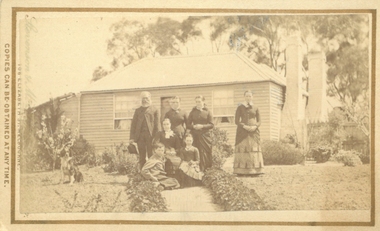
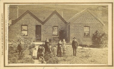
Photograph, Burnip Family and House Coimadai 1883
... by sending the Name and Post Office Money Order or Stamps... of this Portrait can be had at any time by sending the Name and Post Office ...The family group in this image is the Burnip family. George Burnip came to Australia in 1854. In 1856 he married Julia Grant. Sometime after this he came to the Bacchus Marsh area and purchased a farm near Coimadai and named it 'The Pines'. George Burnip was active in public affairs as a member of School Board of Advice and the Agricultural Society. One of the two men in this image is likely to be George Burnip, probably the man on the left. The man standing on the right is possibly his son, John, who would have been 22 at the time this photo was taken. The woman seated on a chair placed on the pathway is probably Mrs Julia Burnip. The woman standing with her arms crossed is possibly Mrs Julia Carroll (nee Burnip). The children pictured are likely to be the five Burnip children and two others.Small sepia unframed photograph on card with gold border framing photograph. Housed in the album, 'Photographs of Bacchus Marsh and District in 1883 by Stevenson and McNicoll'. An image showing a brick house with a pitched roof in three separate sections. Two chimneys on either side of the house can be seen. Standing in front of the house is a group of people, male and female, young and old. One female is older and is seated in a chair. At the front of the group is a dog.On the front: Stevenson & McNicoll. Photo. 108 Elizabeth St. Melbourne. COPIES CAN BE OBTAINED AT ANY TIME. On the back: LIGHT & TRUTH inscribed on a banner surmounted by a representation of the rising sun. Copies of this Portrait can be had at any time by sending the Name and Post Office Money Order or Stamps for the amount of order to STEVENSON & McNICOLL LATE BENSON & STEVENSON, Photographers. 108 Elizabeth Street, MELBOURNE houses coimadai vic, stevenson and mcnicoll 1883 photographs of bacchus marsh and district, houses bacchus marsh, burnip family bacchus marsh -
 Bacchus Marsh & District Historical Society
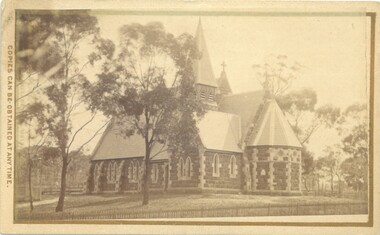
Photograph, Holy Trinity Church Bacchus Marsh 1883
... by sending the Name and Post Office Money Order or Stamps... of this Portrait can be had at any time by sending the Name and Post Office ...The Holy Trinity Anglican Church in this location was first opened in 1877. An earlier nearby prefabricated Church building known as the 'Iron Church' had served as the Anglican place of worship in Bacchus Marsh from around 1855 until 1877. The 1877 sandstone Church with a slate roof was intended as a permanent structure for Anglican worship in Bacchus Marsh and still stands in 2024 and continues to function as an Anglican Church. The building was designed by Frederick Wyatt and is described as early English Gothic in style. It was opened on 5 June 1877 by Bishop Moorhouse of Melbourne. The sandstone was acquired from Grant's quarry at Maddingley.Small sepia unframed photograph on card with gold border framing photograph. Housed in the Jeremeas Family Album, which contains photographs of Bacchus Marsh and District in 1883 by Stevenson and McNicoll. The photograph depicts the recently constructed Anglican Holy Trinity Church in Gisborne Road, Bacchus Marsh. The view of the building is from Gisborne Road looking west. From this angle the rear and southern side of the building can be seen. A picket fence along the entrance to the Church grounds can be seen in the foreground.On the front: Stevenson & McNicoll. Photo. 108 Elizabeth St. Melbourne. COPIES CAN BE OBTAINED AT ANY TIME. On the back: LIGHT & TRUTH inscribed on a banner surmounted by a representation of the rising sun. Copies of this Portrait can be had at any time by sending the Name and Post Office Money Order or Stamps for the amount of order to STEVENSON & McNICOLL LATE BENSON & STEVENSON, Photographers. 108 Elizabeth Street, MELBOURNE churches bacchus marsh, holy trinity anglican church bacchus marsh, holy trinity church of england bacchus marsh, stevenson and mcnicoll 1883 photographs of bacchus marsh and district -
 Bacchus Marsh & District Historical Society
Photograph, Thomas Heath's Saddlery Main Street Bacchus Marsh 1883 Image 2
... by sending the Name and Post Office Money Order or Stamps... of this Portrait can be had at any time by sending the Name and Post Office ...Thomas Heath built this shop for his saddlery business around 1875. In 1926 after 58 years operating his saddlery in Bacchus Marsh he retired and the assets of his business were sold in a clearing sale. The building was later demolished. Apart from his services in saddlery his premises was known to be a gathering place for much discussion. Heath was known to openly express his political opinions and his saddlery premises was known by many in the community as the 'Parliament'.Small sepia unframed photograph on card with gold border framing photograph. Housed in the album, 'Photographs of Bacchus Marsh and District in 1883 by Stevenson and McNicoll'. The photo is of a double-fronted weatherboard building with a shingle roof. The front gabled section stands directly on street level and is flanked by a picket fence. The door and overhead window and the side window with arched panels may indicate that this was the shop section, with a dwelling to the rear. The recessed side section of the building with a twelve-sectioned window, chimney and a back extension was probably the dwelling used by the family. In the doorway stands the saddler, probably Thomas Heath. To his left is a woman, possibly Mrs Heath, and a much younger woman, possibly a daughter of the Heaths. In front of the two women is a small dog. A hitching rail runs along the front of the workshop. Indicating the type of business Mr Heath ran. On the front: Stevenson & McNicoll. Photo. 108 Elizabeth St. Melbourne. COPIES CAN BE OBTAINED AT ANY TIME. On the back: LIGHT & TRUTH inscribed on a banner surmounted by a representation of the rising sun. Copies of this Portrait can be had at any time by sending the Name and Post Office Money Order or Stamps for the amount of order to STEVENSON & McNICOLL LATE BENSON & STEVENSON, Photographers. 108 Elizabeth Street, MELBOURNE. saddleries, saddlers, thomas heath 1842-1930 saddler, heath family bacchus marsh, stevenson and mcnicoll 1883 photographs of bacchus marsh and district -
 Kiewa Valley Historical Society
Book - Kergunyah Telephone Numbers
... the switchboard usually situated at the local post office. This book lists... situated at the local post office. This book lists the residents ...In rural Australia phone calls were made through the switchboard usually situated at the local post office. This book lists the residents of Kergunyah and their phone numbers. If you want to talk to a neighbour for example, you ask for that person or give the operator their number. The switchboard operator 'puts the caller through'. However some people shared a number and were therefore on a party line eg. in this book 6 people share number 3. The operator would then ring the individual's code, like morse code, eg. 1 long 2 short. Also ref. KVHS 0897 Mt Beauty SwitchboardThis book is a list of residents living at Kergunyah who have a phone and lists their phone numbers. Kergunyah is in the Kiewa Valley. The book also notes some problems with the line eg. 'suspect sheath damage'. Stiff beige cardboard cover bound by black tape "Subscribers' M.D.F. / Record" printed on centre of cover. 7 pages but only written on pages 2 and 3 with residents' names and phone numbers in columns."Kergunyah" on front coverkergunyah, telephone, kiewa valley, switchboard -
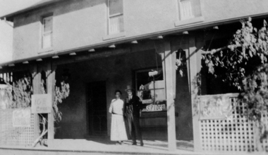 Greensborough Historical Society
Photograph - Digital image, Marble Hall, 1930-1940
... functions over the years including post office, general store... but served many functions over the years including post office ...Photograph of "Marble Hall", Greensborough. The Marble Hotel, Greensborough was located at the corner of Main Street and Para Road. The first licensed hotel in Greensborough and one of the earliest brick buildings was built by James Chapman in the early 1850s as a hotel and lodging house to cater for wood carters and those trying their luck at the gold fields but served many functions over the years including post office, general store, public hall, butchers, bakers, surgery, private dwelling and baby health care centre. It got its name due to its white washed exterior. This photo is from the Lorraine Coates Collection.Photograph of early Greensborough building, now demolished.Digital copy of black and white photograph.marble hotel greensborough, james chapman, marble hall greensborough -
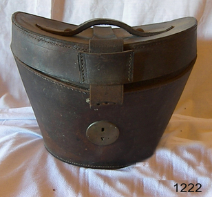 Flagstaff Hill Maritime Museum and Village
Functional object - Hat box, 1890-1910
... store at Post Office Place Melbourne between 1884 when the store... & Moffatt department store at Post Office Place Melbourne between ...The item was purchased from Robinson & Moffatt department store at Post Office Place Melbourne between 1884 when the store opened. Between 1911 and 1934 Robinson & Moffatt appeared to have sold out along with other businesses to became part of the Myer Emporium. Robinson & Moffatt were an early upmarket department store for the wealthy with a branch in Perth that was opened in 1899. During their time in business Robinson & Moffatt appear to have imported goods from England and Europe. The hatbox appears to be a British pattern made for a beaver type top hat around late 19th or early 20th century. A personal item made for Robinson and Moffatt department store, imported from England and sold to a wealthy colonial gentleman sometime between the late 19th and early 20th century. The item was purchased from one of the earliest department stores in Melbourne, that later was incorporated into what has become an iconic Australian department store operating out of one of Melbourne's iconic building locations,the Myer emporium.Gents leather oval hat Box, with concave lid reinforcing strap and leather handle. Has metal locking device and key hole. Handle held to top with 2 studs. Velvet inside lid. Catch inside box."Made for Robertson & Moffatt Melbourne"flagstaff hill, warrnambool, shipwrecked coast, flagstaff hill maritime museum, maritime museum, shipwreck coast, flagstaff hill maritime village, great ocean road, hat box, gentleman's hat, gent's hat box, hatbox -
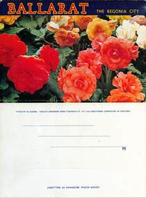 Ballarat Tramway Museum
Postcard - Folder Set, Nu-color-vue or Nucolorvue Productions, "Ballarat the Begonia City", early 1960s
... Post Office, looking west up Sturt St with a number of trams... at the Shell House, Ballarat Post Office, looking west up Sturt St ...Published by Nucolorvue Productions of Moorabbin Vic. Features photos the Imperial Crown at the Shell House, Ballarat Post Office, looking west up Sturt St with a number of trams in the City Loop. It would appear that the trams have been fitted with dash canopy lightings which dates the photo to early 1960s to mid 1960s. As well Eureka Stockade, Civic Hall, Lake Wendouree, Bridge St from Stones Corner that shows the tramway overhead and signals, Arch of Victory, Sturt St Statuary and Gardens, Begonia House, The Gardens and the Floral Clock with the Town or City Hall. Demonstrates a postcard folder produced by Nucolorvue.Printed colour postcard folder titled "Ballarat The Begonia City", featuring a photo of begonias on the cover and an address box on the rear of the folder.sturt st, city loop, postcards, gardens, lake wendouree, begonias, eureka stockade, shell house -
 Melbourne Tram Museum
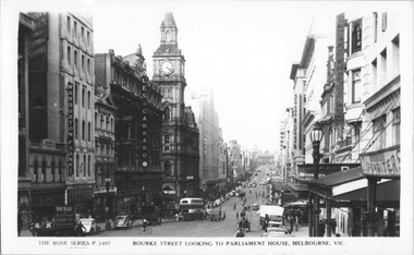
Postcard, Rose Stereograph Co, "Bourke Street looking to Parliament House, Melbourne", late 1940s
... Engineers; Coles & Garrard, Optometrist; General Post Office (GPO...; Coles & Garrard, Optometrist; General Post Office (GPO); Myer ...Rose Series postcard No. P 3497, titled "Bourke Street looking to Parliament House, Melbourne". Photo looking east from near Queen Street with one double decker bus at the Elizabeth Street stop with other buses in the distance. Two trams can be seen in Elizabeth Street on either side of Bourke Street. A horse drawn cart can be seen climbing the hill. On the northside of the Bourke Street can be seen, Warburton Franki & Co, Electrical Engineers; Coles & Garrard, Optometrist; General Post Office (GPO); Myer; Buckley and Nunn and Foy's department stores. Yields information about Bourke Street mid to late 1940s.Postcard - printed real photograph with Rose Stereograph Co. name on the rear.tramways, trams, bourke st, buses, elizabeth st, mmtb buses, leyland, td5c class -
 Melbourne Tram Museum
Document - Historical notes - Box Hill Tramway and other Victorian Tramways
... Hill Post Office today marks the terminus" Provides notes... - typed notes with the heading "a tablet beside the Box Hill Post ....1 - typed notes with the heading "a tablet beside the Box Hill Post Office today marks the terminus" Provides notes on the Box Hill - Doncaster electric tramway of 1888, some historical notes about its operation and closure. Includes notes on Bendigo's battery trams, steam trams, SA's Goolwa to Port Elliot tramway, Fairfield horse tramways and other horse trams. No information as to who prepared the original document - possibly Bob Prentice. .2 - an extract from a publication showing the commemorative cairn at the Box Hill terminus and providing some notes on the tramway.Yields information about the first Australian electric tramway and other tramways in Victoria..1 - Foolscap sheet - blue paper, typed notes on the Box Hill - Doncaster Tramway and other Victorian Tramways. .2 - digital scan of a publication showing the commemorative cairn at Box Hilltramways, trams, box hill, electric trams, victorian tramways, commemorative, monuments, steam trams, bendigo, doncaster -
 Bendigo Historical Society Inc.
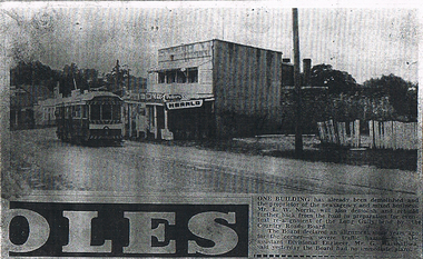
Newspaper - LONG GULLY HISTORY GROUP COLLECTION: EAGLEHAWK ROAD
... Street) now known Eaglehawk Road. On Left Post Office - now... of Long Gully (Bond Street) now known Eaglehawk Road. On Left Post ...Photocopy of a newspaper article and photo of Eaglehawk Road with a tram outside a two story newsagency. On the right is a dilapidated timber fence. Written on the back is: approx 1966 ? One of the last trams No. 18 to run up Main Street of Long Gully (Bond Street) now known Eaglehawk Road. On Left Post Office - now Gents Hairdresser & Rose of No. 3 Australia Hotel. On right Les & Marie Norris Newsagency & Mixed Business. 2 story Building was Commercial Hotel. No. 26 Tram was the last To Run between Bendigo , Long Gully & Eaglehawk still running as a Tourist tram in Bendigo 1987. Donated by Alan Crossley 1985.bendigo, history, long gully history group, the long gully history group - eaglehawk road, mr l w norris, country roads board, mr g marshallsea, rose of australia hotel, les & marie norris, commercial hotel, alan crossley -
 Bendigo Historical Society Inc.
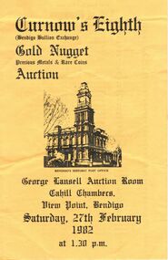
Document - IAN DYETT COLLECTION: AUCTION CATALOGUE - CURNOW'S EIGHTH GOLD NUGGET PRECIOUS METALS
... of Bendigo's Historic Post Office. The inside contains a list... is a black sketch of Bendigo's Historic Post Office. The inside ...Yellow catalogue with black printing for Curnow's Eighth Gold Nugget Precious Metals & Rare Coins Auction held in the George Lansell Auction Room, Cahill Chambers, View Point, Bendigo on 27th February 1982. On the front is a black sketch of Bendigo's Historic Post Office. The inside contains a list of Nuggets with Lot No., Approx. Weight in Grams, Area of Find, Code, Stone from Brazil, some jewellery and List of Coins. The left front has the Conditions of Sale and the centre front has Curnows name and a Reproduction of Curnows original Letterhead circa 1900. Sale includes nuggets from Tarnagulla, Bendigo, Maryborough, Inglewood and Myrtleford.business, auctioneers, j h curnow & son pty ltd, ian dyett collection - auction catalogue - curnow's eighth gold nugget precious metals & rare coins auction, bolton bros pty ltd, j h curnow, j h curnow & son pty ltd, ian dyett, fred dyett -
 Bendigo Historical Society Inc.
Document - BADHAM COLLECTION: EXHIBITION LABELS X 15 - CARDBOARDS
... Exhibition labels x 15 - cardboards Railway Post Office... Post Office stamps, 1865, and book 1951 - Courtesy Edna ...Exhibition labels x 15 - cardboards Railway Post Office stamps, 1865, and book 1951 - Courtesy Edna Westhead. Copy of 1887 Map of Railway Post Offices - Courtesy Edna Westhead Taken in 1921, Bendigo railway men celebrating 50 years since first train arrived in Bendigo in 1862 - Courtesy Bendigo Historical Society Book of Signals, 1949 - Courtesy Bernie Kingdon Book of Instruction Rolling Stock 1921, 1943 - Courtesy Bernie Kingdon Lost Property Book, 1886 - Courtesy Ross Rowley View of Bendigo Railway Station taken from St. Paul's tower, 1875 - Courtesy Bendigo Historical Society...document, memo, railway -
 Bendigo Historical Society Inc.
Document - ADDRESS TO JACOB COHN - ILLUMINATED, 1888-1889
... of Post Office. Frame gilt embossing. ** Lent to Leo Bruinier... councillors. Photo of Town Hall. Photo of Post Office. Frame gilt ...Jacob Cohn. Esq. Mayor of Sandhurst 1889-89. Dear Sir. In accordance with a special resolution of the city council and an old established custom we have much pleasure in presenting you this illuminated address with our photos as a small token of our esteem in which you are held by us. During your year of office as chief magistrate and Mayor of Sandhurst. Signed by all councillors. Photo of Jacob Cohn. Esq. Plus 9 councillors. Photo of Town Hall. Photo of Post Office. Frame gilt embossing. ** Lent to Leo Bruinier to be restored 2015 by Nicholas Truscott. Currently on loan to Bendigo Art Gallery and displayed in Bendigo Town Hallperson, group, employees