Showing 16059 items
matching area
-
 University of Melbourne, Burnley Campus Archives
Slide - Colour prints, Report on PictureTel
7 slides labelled, "For use with the report: The interconnectivity of PictureTel desktop and room systems, for multiple applications." Not digitised.interconnectivity, picturetel desktop, communications -
 University of Melbourne, Burnley Campus Archives
Photograph - Colour prints, Staff Gatherings, 1980-1990
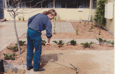
2 sets of photographs not scanned. Paula Cave in newly planted Quad Courtyard (scanned). 1 set outside the Student Amenities Building with staff members at a barbecue. Also 1 set Staff gathering in unidentified place.student amenities building, staff, paula cave, quad courtyard, greg moore, james hitchmough -
 University of Melbourne, Burnley Campus Archives
Photograph - Negatives, Debate, C. 1985
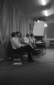
Set of negatives. Peter May, Joylon Burnett, James Hitchmough John Patrick and Greg Moore. The occasion was a debate that Greg Moore ran as part of Plant Sciences before he became Principal. Greg Moore thinks John Patrick was the moderator and they had a very highly qualified adjudicator from the debating society. It would have happened in about 1985 and there were only a few of them. Greg Moore thinks this one was on, "The Genus Eucalyptus Should Be Sub-divided." The debate was decided in the affirmative. They had a good roll up as you can see and all staff and students were invited to attend, not just those in the subject. students, debate, eucalyptus genus, greg moore, peter may, john patrick, joylon burnett, james hitchmaugh -
 Orbost & District Historical Society
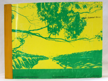
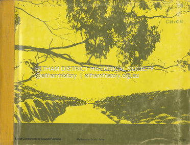
book, Report on the East Gippsland Study Area, June 1974
In 1961 Bruce Evans was elected to the Victorian Legislative Assembly as the member for Gippsland East. He was the party's deputy leader from 1964 to 1970 and its whip from 1970 until his retirement in 1992. "The Land Conservation Council was established by the Land Conservation Act 1970. As one of its three functions, it makes recommendations to the Minister for Planning and Environment with respect to the use of public land, in order to provide for the balanced use of land in Victoria. This report contains the Council’s final recommendations concerning the use of public land in the East Gippsland study area, the boundaries of which correspond to those of the Shire of Orbost. The recommendations in the text are grouped under major headings, such as Parks, State Forest, and so on. " The Council met on seven occasions during the year, and also made visits of inspection to each study area. The Chairman visited Shire Councils in study areas to explain the role and the functions of the Land Conservation Council and to invite submissions on the use of public land in these areas. This is the fourth annual report by the council. This is a useful research tool.A large book 236 pp book with a yellow / gold cover with a green bush scene . The binding is orange. It contains folded maps and information on public land use in East Gippsland.inside - "With Compliments - Bruce Evans, M.P."east-gippsland-study-area conservation public-land-use -
 Greensborough Historical Society
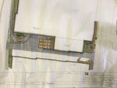
Plan, TTM Consulting, Valley Central Shopping Centre, Myer Loading Area, 1993_11
Plan for the pavement finishes at the Myer loading area at Valley Central Shopping Centre (now Greensborough Plaza) between The Circuit and Church Street.Plan of loading dock showing pavement finishes. Colour and black ink on white paper.greensborough plaza, the circuit greensborough, church street greensborough -
 Kiewa Valley Historical Society
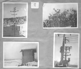
Sheets 9 and 10 of set of 10 sheets/ black and white photographs of the Kiewa area, 1948 - 1950's
These photographs are a pictorial and historical record of the photographer, Ronald George Thorn, of his days as an engineer with SECV. He worked in the Kiewa area as a cadet engineer from 1948 to 1950 and then in 1953 to 1956 as an electrical engineer grade 2.The photographs tell the story of one man's involvement in the construction of the Kiewa Hydro Electric Scheme during his employment with the state Electrical Commission of Victoria.A foolscap sized sheet of lightweight cardboard, brown in colour, with 8 small black and white photographs on page 9 and 4 small photos on page 10.Number 9 is written in ink on a small square of white paper and adhered to the page with sticky tape. The number 10 is also written on a small square of white paper and adhered to the reverse side with sticky tape. kiewa area, engineer, photographs -
 Eltham District Historical Society Inc
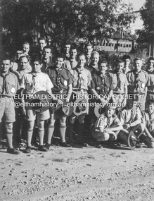
Photograph - Black and White Print, Lewis Tulk, Yarra Batman Area Scout Stage III training at 1st Eltham Scout Hall, Youth Road, Eltham, c.1980
In the background a 'Red Rattler' Tait train is visible at Eltham Railway Station. Donated by Lewis Tulk, former Scout Area Training Commisioner for Leaders.Inscribed on reverse: YBA Scout Stage III 1st Eltham Scout Hallscouts victoria, scout leader training, lewis tulk collection, 1st eltham scouts, eltham, red rattler, tait train, yarra batman area, youth road -
 Greensborough Historical Society
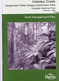
Booklet, Parks Victoria, Wallaby Creek: designated water supply catchment area. Kinglake National Park: Draft management plan 1998, 1998_02
Wallaby Creek is part of Kinglake National Park, and is a restricted access catchment area to protect quality of water supplied to Melbourne's water supply system. 26 p. black print on white paper, green cover, three folded mapskingllake national park, water supply, wallaby creek, parks victoria -
 National Vietnam Veterans Museum (NVVM)
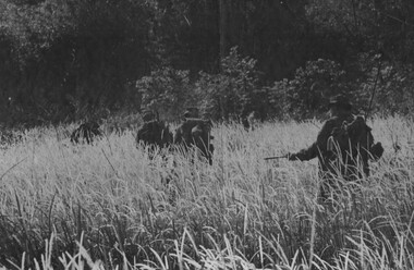
Photograph, Gibbons, Denis, Patrolling Suspected VC Area
Denis Gibbons (1937 – 2011) Trained with the Australian Army, before travelling to Vietnam in January 1966, Denis stayed with the 1st Australian Task Force in Nui Dat working as a photographer. For almost five years Gibbons toured with nine Australian infantry battalions, posting compelling war images from within many combat zones before being flown out in late November 1970 after sustaining injuries. The images held within the National Vietnam Veterans Museum make up the Gibbons Collection. A black and white photograph of some D Company, Headquarters Personnel 6 RAR/NZ(ANZAC), patrolling toward a suspected VC area during Operation Lavarack (June 1969). Left to right L/Cpl D.S Devantier, L/Cpl J Gostynski, Lt G R Spencer, Maj I T Stewart and Gnr G K Grantphotograph, d coy, 6 rar/nz, operation lavarack, vc, gibbons collection catalogue, l/cpl d.s devantier, l/cpl j gostynski, lt g r spencer, maj i t stewart, gnr g k grant, 6 rar/nz (anzac), viet cong, denis gibbons -
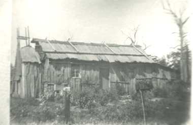 Lakes Entrance Historical Society
Photograph - Bark hut at Lake Tyers area Victoria, Bark hut at Lake Tyers area Victoria, 1900 c
Second identical copy 04618.1Black and white photograph of a bark hut showing walls of vertical sheets of bark held in place by horizontal battons. On the roof overlapping sheets of bark are held in place by a horizontal log attached to the saddle pole on the roof ridge by vertical timbers. Nails were not used wooden pegs or greenhide strips kept the frame stable. This building believed to be in the Lake Tyers area Victoriahouses, land settlement -
 Greensborough Historical Society
Folder, Investors in the Grace Park area - Fricker Brothers 1957, 2018_05
Collection of records regarding the acquisition of land by the Fricker brothers in the Grace Park area of Greensborough, and their sub-division and sale between 1957 and 1975. Researched and edited by Peter Simmenauer Folder containing Certificates of Title, photocopies of Death Certificate and Probate documents, list of land sales and historical notes, researched and edited by Peter Simmenauer grace park, fricker avenue greensborough, desmond court greensborough, desmond fricker -
 Kiewa Valley Historical Society
Sheet 1 - nine small black and white photos. Sheet 2 - eight small black and white photographs, c 1948 and early 1950's
These photos are a pictorial and historical record of the early construction days of the Kiewa Scheme and a personal record of the photographer, Ronald George Thorn, of his days as an engineer with the SECV. He worked in the Kiewa area as a cadet engineer from 1948 to 1950 and then in 1953 - 56 as an electrical engineer grade 2.These photographs tell the story of one man's involvement in the construction of the Kiewa hydro electric scheme during his employment with the SECV.A foolscap sized sheet of light weight cardboard with nine small black and white photographs pasted on side 1 and eight same sized black and white photographs pasted onto side 2. The number 1 is handwritten in ink on a small square of white paper and adhered to the top of the sheet. On the other side of the sheet is number 2, handwritten in ink on white paper and adhered to the top of the sheet with sticky tape. secv, engineer, kiewa -
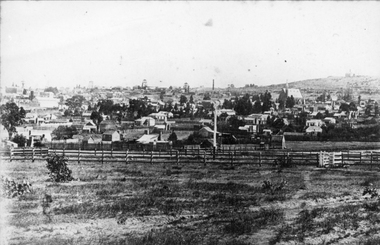
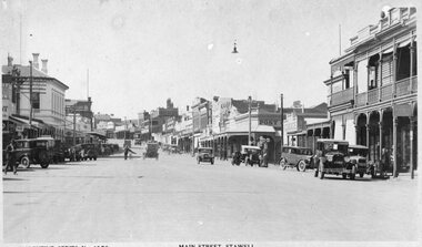
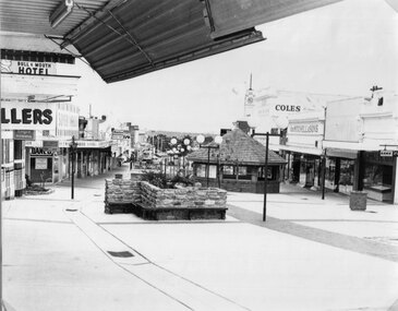 Stawell Historical Society Inc
Photograph, Main Street looking West from Fountain Area down Gold Reef Mall c1984
Main Street looking West from Fountain Area down Gold Reef Mall Shows Rotunda and planter boxes. Bull and Mouth Hotel at left of photo Geo Mitchell at right. C1984stawell businesses, streetscape -
 Stawell Historical Society Inc
Photograph, Town & Big Hill from King Street area c1900
Town & Big Hill from King Street area. c1900 Market Building in Skene Street visible in left of photo. St Patrick's Church on Right. Rail line and signal pole in foreground of photo across image.stawell, streetscape, panorama -
 Stawell Historical Society Inc
Photograph, Main Street Stawell looking East from area in front of Town Hall -- Postcard c1930
Valentine Series No 1078 Main Street looking East from area in front of Town Hall c1930 Town Hall Hotel Post Office and Post Office Hotel and Bull and Mouth Hotel are visible. Vehicles in street.Valentine Series No. 1078 Main Street Stawellstawell business streetscape -
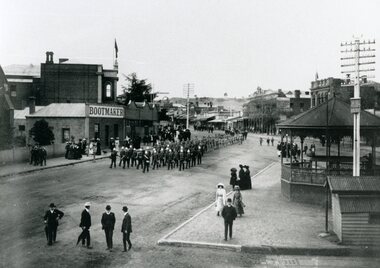 Stawell Historical Society Inc
Photograph, Bandsmen leading Senior and Junior Cadets in Main Street Stawell looking East from Memorial Area 1908
Parade of Bandsmen leading Senior and Junior Cadets in Main Street looking East from Memorial Area 1908. Boot makers shop between Town hall and Anglican Church on left Town Hall Hotel and shops on right with band rotunda to right of photo.stawell band pavillion boer war streetscape -
 Ringwood and District Historical Society
Map - State Aerial Survey, Dandenong Ranges Area Sheet 7, Parishes of Warrandyte, Scoresby, Ringwood and Nunawading - 1956
Map of central and southern areas of Ringwood and part of Ringwood East and Heathmont compiled by Dept of Lands and Survey, July 1956, from aerial photographs and Cadastral Survey information. Subsequent coloured hand-drawn additions showing layout of a number of post-NSW Separation era proposed subdivisions that did not eventuate, including Village of Studley Estate, Township of East Kew Estate, Township of Ballyduffy Estate, Township of New Flemington Estate, Township of East Hawthorne Estate. Ringwood A4B2, 849 A4B Zone 7. Scale: 10 chains to 1 inch. Contour interval 20 feet. -
 Kiewa Valley Historical Society
Maps - Bogong x2, Tawonga, Omeo, Dargo, Victoria and others, 1. Bogong Alpine Area; 2. Bogong 8324; 3. Tawonga Topographical; 4. Omeo 8433; 5. Dargo 8323; 6. Victoria State
1. Bogong Alpine Area (outdoor Leisure Map. survey & Mapping Victoria, Government of Victoria, Edition 2, reprinted 1991 with an image of Mt. Feathertop on the front. Information for tourist in the Alpine National Park: Bogong Area. Including: recreational activities, history, weather and vegetation and a list of walks together with locality maps and photographs. The front cover has an image of Mt Feathertop against a blue sky with yellow writing 'Bogong Alpine Area', there is a yellow triangular block on the right hand top corner with black writing 'Outdoor Leisure Map. On the bottom edge is a block of yellow with black writing 'Survey & Mapping Victoria' and a light green map of Victoria with 'VICMSP' printed in white. 2. 8324 Bogong Victoria, Edition 1, Commonwealth of Australia 1981. A topographical Map: 1:100,000 scale (1 cm to 1 KM). Map has a red cover with white writing together with a white block and black writing and a map insert. 3. Tawonga Topographical Map - Forests Commission Victoria, / revised 5/9/77, DEG No. 68-G/399. A Tawonga 803 folded map in a beige colour with the back blank. 4. Omeo 8433 Victoria, Edition 1, Department of Natural Resources. The map has a red and white cover with black writing and a simple map of Australia at the bottom. 5. 8323 Dargo, Edition 1, Commonwealth of Australia. A red and white cover with a map insert. 6. Victoria State Map, Hema Maps, 2002. Hema Maps, State Map, colourful cover with a map of Australia and four tourism photographs. Scale 1: 850,000 An inscription handwritten in blue pen "Trappers Gap to Mitta Mitta 1" to 1 mile". There are some pen markings and notations of tracks.maps, bogong, omeo, tawonga, dargo, victoria, bogong alpine area -
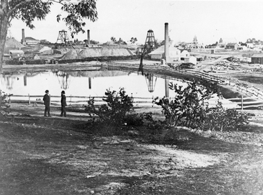 Stawell Historical Society Inc
Photograph, The Pleasant Creek Cross Reef No1 Shaft Panorama of a Mining Scene in the Duke Sands area c1875
Mining Scene Duke Sands area c1875 Behind the tree on left is Extended Cross Mine and on the right is the Oriental Mine. In the centre is the North Cross Mine No1 shaft. In the foreground is one of the Moonlight dams. St Peters Lutheran Church in Scallan Street can be seen on the right horizon. Two mines and workings on other side of Moonies settling dam. Two Gentlemen lower left cornerstawell mining -
Ballarat Tramway Museum
Document, Hector Bell Junior, "Street passenger transport system of Geelong Urban Area", 1949
Report by Hector H Bell Junior of the MMTB early 1949, titled "Street passenger transport system of Geelong Urban Area". Looks at the history of public transport in Geelong, tramway data, financial analysis, the Geelong bus system, buses servicing the North Shore industries - principally the Ford Works, the condition of the bus fleet, taxi and private car hire services, functions of a street transport authority, town planning, populations and traffic surveys, relative values of passenger vehicles, trolley buses, industry and recommendations. Said the tramway system was obsolete, should be a rail service between North and South Geelong, set up a street transport body, replan the Geelong railway station, additional roads to service the North Shore area. Refers to attachments. Has a list of people involved in the preparation of the report. See item 112 for the AETA response of April 1949 to this report.Yields information about the Geelong tram and bus services in 1948/49 and how it could be developed or reformed. Has a close association with Hector Bell Junior, the son of the then MMTB Chairman.Document - 18 foolscap sheets photocopied and stapled in three places along the side.tramways, secv, geelong, statistics, history, passenger services, reports, aeta -
 Greensborough Historical Society
Photograph - Digital image, Marilyn Smith et al, Janefield Precinct: Looking toward grave area from camp, 27/11/2014
Janefield Precinct: Looking toward grave area from camp. The remains of this site are between Greensborough and Janefield. A RAAF Hygiene Training Camp was located on the Plenty River, just south of the Janefield community. It was in use from 1944 to 1946. The Camp was constructed from salvaged materials. Instruction included building and maintenance of grease traps, latrines, elementary plumbing and carpentry.Early remains of a WW2 training camp Digital colour photograph. -
 Melbourne Tram Museum
Document - Report, Melbourne & Metropolitan Tramways Board (MMTB), "Schedule of Motor Omnibus Routes Metropolitan Area, 1/08/1930 12:00:00 AM
Set of 9 typed full foolscap sheets, stapled on the left hand side with a blue cover strip titled "Schedule of Motor Omnibus Routes prescribed within the Metropolitan Area for the Period 1st January 1930 to 31st December 1930". Dated by hand in the top right hand corner "1.8.30". Lists the route number, route, sections, service (frequency), fares, bus number authorised and actually licensed. Does not list the operator. For full pdf of file see i2.pdf See also Reg Item 2682 for a similar 1938 listing.trams, tramways, regulations, mmtb, tramways, buses -
 Puffing Billy Railway
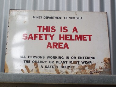
Sign - Safety Helmet Area
Sign - Safety Helmet Area, Mines Dept. of VictoriaHistoric - Safety Sign used by Mines Dept. of Victoriametal sign - Sign - Safety Helmet Area Mines Department of Victoria This is a Safety Helmet Area All persons working in or Entering The Quarry or Plant must wear A Safety Helmetpuffing billy, sign - safety helmet area,, mines dept. of victoria -
 Greensborough Historical Society
Photograph - Digital Image, Anne Paul, Opening of restored Old Lower Plenty Bridge 2001 - area adjacent, 14/03/2001
The opening of the restored Old Lower Plenty Bridge, opened on 14/03/2001 by the Minister for Environment and Conservation Sherryl Garbutt MLA and Mayor of Banyule Cr Dale Peters. The project was jointly funded by Banyule Council and Parks Victoria. The restored bridge is the oldest remaining bridge in Nillumbik and forms part of the Plenty River Trail. this photograph shows the area adjacent to the bridge on the day of the opening.Digital copy of colour photographlower plenty, lower plenty bridge, sherryl garbutt, dale peters, banyule council, parks victoria -
Whitehorse Historical Society Inc.
Article, Fourth zone added to flats control, 1969
A report on a decision adopted at a Council meeting to divide the municipality into four areas for planning purposes.A report on a decision adopted at a Council meeting to divide the municipality into four areas for planning purposes.A report on a decision adopted at a Council meeting to divide the municipality into four areas for planning purposes.residential development, city of nunawading, town planning -
 Eltham District Historical Society Inc
Book, Land Conservation Council, Report on the Melbourne Study Area, December 1973
This report is one of a series describings the physical nature of the land and its environment, examines the likely forms of land use, and assesses the hazards associated with these uses. It is divided into four main sections: Introduction, Characteristics of environment, main forms of land use and description of 24 specific blocks in the study area which include Torquay, Brisbane Ranges, Werribee, Wombat, Loddon, Romsey, Puckapunyal, Strathbogie, Eildon, Disappointment, Break O'Day, Black Range, Cerberean, Upper Goulburn, Kinglake, Donna Buang, Upper Yarra, Thomson, Dandenongs, Bunyip-Latrobe, Shady Creek, Tyers, Westernport and Strzelecki. The Land Conservation Act 1970 established the Land Conservation Council whose functions is to "carry out investigations and make recommendations to the Minister with respect to the use of public land in order to provide for the balanced use of land in Victoria. This report sets out to describe and assess the natural resources of the public lands in the Melbourne area and provides a factual basis on which members of the community may base submissions to the [Land Conservation] Council of Victoria.444 pagesnon-fictionThis report is one of a series describings the physical nature of the land and its environment, examines the likely forms of land use, and assesses the hazards associated with these uses. It is divided into four main sections: Introduction, Characteristics of environment, main forms of land use and description of 24 specific blocks in the study area which include Torquay, Brisbane Ranges, Werribee, Wombat, Loddon, Romsey, Puckapunyal, Strathbogie, Eildon, Disappointment, Break O'Day, Black Range, Cerberean, Upper Goulburn, Kinglake, Donna Buang, Upper Yarra, Thomson, Dandenongs, Bunyip-Latrobe, Shady Creek, Tyers, Westernport and Strzelecki. The Land Conservation Act 1970 established the Land Conservation Council whose functions is to "carry out investigations and make recommendations to the Minister with respect to the use of public land in order to provide for the balanced use of land in Victoria. This report sets out to describe and assess the natural resources of the public lands in the Melbourne area and provides a factual basis on which members of the community may base submissions to the [Land Conservation] Council of Victoria.land use, kinglake, thomson valley, conservation, public lands -
Melbourne Tram Museum
Newspaper, The Age, "Tram drivers say end of 86 route a dangerous area", 19-1-2019 to 13/5/2019
Newspaper clippings from The Age titled: "Tram drivers say end of 86 route a dangerous area" - 19-1-2019 "Public transport sex attacks surge" - 26-1-2019 "Sex attacks on trains trams surge" - 26-1-2019 "Transgender fears over tram train travel" - 4-2-2019 "I was groped on the tram - not for the first time" - 15-2-2019 "Woman followed off tram assaulted" - 13/5/2019 Series of article about safety of travelling on public transport following the murder of Aiia Maasarwe on the Bundoora tram Jan. 2019.trams, tramways, public transport, route 86, behaviour, bundoora, police, safety -
 Eltham District Historical Society Inc
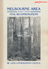
Book, Land Conservation Council, Melbourne Area, District 2 Review: Final Recommendations, 1994
Notices showing the boundary of the area of the review and advising that an investigation was to be carried out were published in the Victoria Government Gazette and in local and other Victorian newspapers in May 1987. A descriptive resources report was published in August 1991. Council received 1,425 submissions and letters following publication of the descriptive report. The Council considered these submissions and published proposed recommendations in April 1993. A further 1,993 submissions were received in response to the proposed recommendations. The Council published its final recommendations in July 1994. A change to legislation in 1989 enabled the LCC to make recommendations for public land within a ‘town’, though cities and rural cities remained excluded from the definition of public land. Timber resources and water quality and yield from timbered catchment areas remained significant issues in Melbourne’s catchments. Recommendations for the Yarra Ranges National Park were based around the closed Melbourne water catchments and adjoining state forest. A recommended Phillip Island State Park based around the penguin reserve was ultimately implemented as the Phillip Island Nature Park.Shire of Nillumbik DPE/Enviro -
Ringwood and District Historical Society
Family History, Eva McLaren (now Moore), Single page dated 11 March 2003 - typed notes on the McLaren family having lived in the Bedford Road area of Ringwood from April 1927, 11-Mar-03
Single page of typed notes on the McLaren family having lived in the Bedford Road area of Ringwood from April 1927, headed "On The Street Where You Live" prepared by Eva McLaren (now Moore), dated 11 March 2003. +Additional Keywords: McLaren, Eva / McLaren, Rev Gilbert / McLaren, Dorothy / Wigley, Linda / Wigley, Evan / Wigley, Ralph / Wigley, Eslie / Wigley, Amy / Wigley, Bernard / Wigley, Ray / Lobascher, Joe / Lobascher, Mary / Evans, Fay / Evans, Mr and Mrs / Woollacott, Eveline / Woollacott, May / Mannix, Dr / Tasker Family / Paddock, Miss / Watson, Clarice / Watson, Bert / Watson, Vera / Swan, Alix -
 Ringwood and District Historical Society
Map - State Aerial Survey, Dandenong Ranges Area, Parishes of Warrandyte and Ringwood - 1956
Map of central and southern areas of Ringwood and part of Ringwood East and Heathmont compiled by Dept of Lands and Survey, July 1956, from aerial photographs and Cadastral Survey information. Subsequent hand-drawn addition of streets showing layout of "Township of Ballyduffy Estate 1858-60", an earlier proposed subdivision that did not eventuate. (See attached 5009b Ballyshanassy_ Melbourne’s lost suburb.pdf for Ballyduffy historical naming relevance). Ballyduffy Estate streets include City Road, West Prussia Road, Duffy Street, Ireland Street, Evans Street, Victoria Street, Regina Street, Short Road, Prussia Road, Duffy Street East, Ireland Street East, Evans Street East, Chapman Street. Misc Topo 93 Sheet 22, Ringwood A4B2. Scale: 4 chains to 1 inch. Contour interval 20 feet.