Showing 417 items
matching 1849
-
 Hand Tool Preservation Association of Australia Inc
Plane, 1823-1849
This item is part of the Thomas Caine Tool Collection, owned by The National Trust of Australia (Victoria) and curated by the Hand Tools Preservation Association of Australia.plane, wood, moulding, round no 14 -
Hand Tool Preservation Association of Australia Inc
Plane, 1823-1849
This item is part of the Thomas Caine Tool Collection, owned by The National Trust of Australia (Victoria) and curated by the Hand Tools Preservation Association of Australia.plane, wood, fillister, sash -
Maldon Vintage Machinery Museum Inc
Steam Engine, C 1849
Thought to be the world's only working example of this engine. Used for driving overhead shafts in workshops, sawmills etc. Restored by members of the MVMM. Found at the Demsters property Shelbourne. Thought to be the only one of its kind in the world.Horizontal steam engine driving a flat belt pulley. Pulley shaft at right angles to engine shaft also carries a large flywheel. A mechanical oiler mounted on the engine base is activated by the engine valve shaft. Engine cylinder and valve housing painted dark green. Engine base, pulley and flywheel painted maroon. Oiler painted mid green.On engine valve box cover - Light green cast iron oval plate with "Cornelius Pettet / Engineer / Edinburgh" Brass plate on oiler - "Delvac Mechanical Lubricator / Design No 18376 / Made for and supplied by / Vacuum Oil Company Pty. Ltd. / Australia"machinery; engines; steam power source -
 Mont De Lancey
Book, John Bishop, Hamilton's Celebrated Dictionary, 1849
A small musical dictionary of 3,500 Italian, French, German, English and other musical terms, phrases and abbreviations, also a copious list of musical characters such as are found in the works of various composers. It has an appendix consisting of a reprint of John Tinctor's First Musical Dictionary known.Small blue softcover book, Hamilton's Celebrated Dictionary comprising an explanation of 3,500 Italian, French, German, English, and other musical terms, phrases and abbreviations. It has an Appendix at the back as well as lists of books for merchants and shoppers of musical items.173p. plus 11 pages of suggested musical items for sale.non-fictionA small musical dictionary of 3,500 Italian, French, German, English and other musical terms, phrases and abbreviations, also a copious list of musical characters such as are found in the works of various composers. It has an appendix consisting of a reprint of John Tinctor's First Musical Dictionary known. dictionary - musical terms, music -
Linton Mechanics Institute and Free Library Collection
Book - Novel, Cooper, J. F. (James Fenimore Cooper), The sea lions : or the lost sealers, [n.d.] [First published 1849, Routledge 'new edition' between 1866-1878. Reprinted 1890s?]
339 p.fictionfiction, james fenimore cooper, t. craig [bookbinder] -
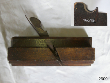 Flagstaff Hill Maritime Museum and Village
Tool - Wood moulding plane, John Partridge, 1815-1851
Not much is known of John Partridge other than he operated his business of making wood planes and other edged woodworking tools in Birmingham. The Birmingham General Directory of the borough of Birmingham businesses of 1849 has him listed as a "Plane/iron maker" however he was probably making planes from around 1815. Birth and death records indicate he was born in 1797 in West Bromwich, Staffordshire England and that he died in 1851. His wife Sarah Nee Ashton he married at Harborne Staffordshire in 1822 and she also died in 1851, it appears they were survived by three children, John born 1826, Sarah 1835, and William 1838. John Partridge tools are now collector's items and represent a time in history when tools of all kinds were predominately still being made by hand in small family workshops. This was during a time known as the first industrial revolution, a time that was regarded as a transition period in history to new manufacturing processes that were occurring in Europe and the United States. A period of industrial change that began about 1760 and lasted until sometime between 1820 to 1840.Moulding plane Side Bead - Single Box type. Partridge maker stamped on end.flagstaff hill, warrnambool, shipwrecked-coast, flagstaff-hill, flagstaff-hill-maritime-museum, maritime-museum, shipwreck-coast, flagstaff-hill-maritime-village -
 Greensborough Historical Society
Article, Journal, Australian Home Beautiful, Lower Plenty State School LP1295, 20/06/1921o
The Australian Home Beautiful article on the Heidelberg and Eastern Golf Club indicates that its clubhouse comprised two buildings, "Bryn Teg" built by Mrs Thomas, one approximately 1849, the other 40 years later. The club moved into these buildings about 1928. The stables were converted for use in 1921 by Frederick Henry Gilsenan as the Lower Plenty State School No. 1295 which was open from 20/06/1921 to 11/04/1925. Mr. Gilsenan married Margaret Mar Cornall in 1923. They lived in Heidelberg, had a daughter, Verna in 1924. Mr Gilsenan was transferred to Mt Moriac SS No. 1608 in 1925. The handwritten account is written by Verna.Historical significance about the premises of both the Lower Plenty State School and the Heidelberg Golf Club.4 p. photocopied article from Australian Home Beautiful 1 June 1929, with 2p.handwritten history of the school 20/06/1921-11/04/1925 (2 copies) and page of photographs of building and people.lower plenty primary school, gilsenan, frederick henry, heidelberg golf club -
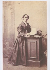 Uniting Church Archives - Synod of Victoria
Photograph, Undated c.1870
Caroline Elizabeth Newcomb (1812 - 1874) woman squatter. Born in London and emigrated to Hobart Town in 1833. She went to Port Phillip in 1836 as governess to the children of John Batman. She met Anne Drysdale in Geelong and they set up a farming partnership. Caroline Newcomb joined the Wesleyan Methodist Society in 1839 and became the first secretary of the Methodist Church at Drysdale, founded in 1849. After Anne's death in in 1853 she continued to run the Coryule property. On 27 November 1861 she married Wesleyan minister the Rev James Davy Dodgson. She died at Brunswick on 3 October 1874. She was buried beside Miss Drysdale at Coryule.Sepia toned enlarged reproduction of original full-length studio portrait of Mrs Caroline Dodgson, formerly Miss Caroline Newcomb. caroline elizabeth newcombe, anne drysdale, rev james davy dodgson, coryule, geelong, hobart town, john batman, squatter, methodist, drysdale -
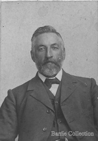
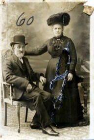 Linton and District Historical Society Inc
Photograph, Yeoman and Co., Sturt St, Ballarat, Mr and Mrs John Inglis
John Inglis was a son of David Inglis and his wife Maria, née Booty. John was born in England in 1949 and came to Victoria in 1857 with other members of his family. David Inglis, John's father, is listed as a baker in Linton in Bailliere's 1868 Victorian Post Office directory. In 1876 John Inglis married Clara Nicholls, a daughter of Henry Nicholls and Marian Nicholls née Downes. Clara was also born in England in 1849, and travelled to Victoria with her parents in 1852. John and Clara Inglis had three children. They moved from Linton to Ballarat, where John worked as a carter. Part of Old Lintonian collection ; No. 60.Sepia photograph of bearded man seated, wearing suit and hat with arms resting on arms of the chair, with lady standing beside him wearing long gown and large hat, right arm resting on chair back.On back - "from Mr and Mrs J Inglis, Ballarat East".john inglis, clara inglis née nicholls, old lintonian collection -
 Camperdown & District Historical Society
Photograph - William and Isabella Taylor (nee Dawson) at "Renny Hill", c1910
Isabella Park Taylor, nee Dawson (1842-1929), friend of Western Victorian First Nations people, and student of their languages and customs. Isabella grew up at "Kangatong" (1844-1866) in the company of First Nations people and became fluent in their languages. With her father, James Dawson, she wrote the book "Australian Aborigines" (1881). She married William Andrew Taylor in 1877 and they built a fine homestead on their property at "Renny Hill'' near Camperdown, Victoria. Together they had two children, Effie, born 1878 and Katherine in 1880. William Taylor (1849-1927) was a farmer, Councillor and civic leader. In 1883 he gifted the world's oldest statue of Robert Burns to the people of Camperdown. William and Isabella Taylor (nee Dawson) seated together in the garden at "Renny Hill".cdhs, cdhsfirstnations, djargurd wurrung, djargurdwurrung -
 Kew Historical Society Inc
Photograph, Floods in North Kew, 1971
Living with natural processes was frequently a challenge to early European settlers and later residents of what was in the 1850s administered by the Borondara Road Board. This was compounded by the area being bounded on three sides by rivers (Yarra River, Koonung Creek and Gardiner's Creek). In 1849, the historian James Bonwick recorded that "our district [Kew] suffered considerably. Mr Wade speaks of 80 acres, out of 100 acres of his cultivated paddock, covered by water." Newspapers continued to describe major flooding in Kew in 1863, 1869, 1878, 1880, 1889, 1891, 1916 and 1934. While the construction of the Upper Yarra dam in 1957 reduced the levels of flowing downstream, local and riverine floods continue.The Kew Historical Society's pictures and map collections testify to the impact of flooding in the district. They have historical importance in documenting the extent of flooding in the district and its affects on homes, services and recreation. Numerous photographs record flooding throughout the Twentieth Century.Floods in North Kew, 1971. Looking northeast towards Kilby Road from River Avenue. Annotation on reverse: map and date "8 Nov. 71 10.30am".floods (kew), yarra river, kew flood, kilby road flood -
 Kew Historical Society Inc
Photograph, Floods in North Kew, 1934
Living with natural processes was frequently a challenge to early European settlers and later residents of what was in the 1850s administered by the Borondara Road Board. This was compounded by the area being bounded on three sides by rivers (Yarra River, Koonung Creek and Gardiner's Creek). In 1849, the historian James Bonwick recorded that "our district [Kew] suffered considerably. Mr Wade speaks of 80 acres, out of 100 acres of his cultivated paddock, covered by water." Newspapers continued to describe major flooding in Kew in 1863, 1869, 1878, 1880, 1889, 1891, 1916 and 1934. While the construction of the Upper Yarra dam in 1957 reduced the levels of flowing downstream, local and riverine floods continue.The Kew Historical Society's pictures and map collections testify to the impact of flooding in the district. They have historical importance in documenting the extent of flooding in the district and its affects on homes, services and recreation. Numerous photographs record flooding throughout the Twentieth Century.Floods in North Kew, 1934. Vicinity of Willsmere Park.floods (kew) -
![Flooding at Chipperfield's Boathouse [East Kew], 1934](/media/collectors/550653872162f11fb04854aa/items/58cbaad5d0cec425b474bfb1/item-media/58cf6fbdd0cf9f331490feb0/item-fit-380x285.jpg) Kew Historical Society Inc
Kew Historical Society IncPhotograph, Flooding at Chipperfield's Boathouse, 1934
Living with natural processes was frequently a challenge to early European settlers and later residents of what was in the 1850s administered by the Borondara Road Board. This was compounded by the area being bounded on three sides by rivers (Yarra River, Koonung Creek and Gardiner's Creek). In 1849, the historian James Bonwick recorded that "our district [Kew] suffered considerably. Mr Wade speaks of 80 acres, out of 100 acres of his cultivated paddock, covered by water." Newspapers continued to describe major flooding in Kew in 1863, 1869, 1878, 1880, 1889, 1891, 1916 and 1934. While the construction of the Upper Yarra dam in 1957 reduced the levels of flowing downstream, local and riverine floods continue.The Kew Historical Society's pictures and map collections testify to the impact of flooding in the district. They have historical importance in documenting the extent of flooding in the district and its affects on homes, services and recreation. Numerous photographs record flooding throughout the Twentieth Century.Floods in North Kew, 1934. Chipperfield's Boathouse and the adding Moorings was located beside the Yarra River near the corner of Willsmere and Kilby Roads. The flood reached the roof of the Moorings, which can be seen in the photo.floods (kew), floods (kew) 1934, yarra river -
 Kew Historical Society Inc
Photograph, Floods in North Kew, 1934
Living with natural processes was frequently a challenge to early European settlers and later residents of what was in the 1850s administered by the Borondara Road Board. This was compounded by the area being bounded on three sides by rivers (Yarra River, Koonung Creek and Gardiner's Creek). In 1849, the historian James Bonwick recorded that "our district [Kew] suffered considerably. Mr Wade speaks of 80 acres, out of 100 acres of his cultivated paddock, covered by water." Newspapers continued to describe major flooding in Kew in 1863, 1869, 1878, 1880, 1889, 1891, 1916 and 1934. While the construction of the Upper Yarra dam in 1957 reduced the levels of flowing downstream, local and riverine floods continue.The Kew Historical Society's pictures and map collections testify to the impact of flooding in the district. They have historical importance in documenting the extent of flooding in the district and its affects on homes, services and recreation. Numerous photographs record flooding throughout the Twentieth Century.Floods in North Kew, 1934. Unidentified location on the Yarra Flood Plain at Kew.floods (kew) 1934, yarra river -
 Kew Historical Society Inc
Photograph, Floods in North Kew, 1934
Living with natural processes was frequently a challenge to early European settlers and later residents of what was in the 1850s administered by the Borondara Road Board. This was compounded by the area being bounded on three sides by rivers (Yarra River, Koonung Creek and Gardiner's Creek). In 1849, the historian James Bonwick recorded that "our district [Kew] suffered considerably. Mr Wade speaks of 80 acres, out of 100 acres of his cultivated paddock, covered by water." Newspapers continued to describe major flooding in Kew in 1863, 1869, 1878, 1880, 1889, 1891, 1916 and 1934. While the construction of the Upper Yarra dam in 1957 reduced the levels of flowing downstream, local and riverine floods continue.The Kew Historical Society's pictures and map collections testify to the impact of flooding in the district. They have historical importance in documenting the extent of flooding in the district and its affects on homes, services and recreation. Numerous photographs record flooding throughout the Twentieth Century.Floods in North Kew, 1934. Chipperfield's Boat House under flood.floods (kew) 1934, yarra river, chipperfield's boat house -
 Kew Historical Society Inc
Photograph, Floods in North Kew, 1934
Living with natural processes was frequently a challenge to early European settlers and later residents of what was in the 1850s administered by the Borondara Road Board. This was compounded by the area being bounded on three sides by rivers (Yarra River, Koonung Creek and Gardiner's Creek). In 1849, the historian James Bonwick recorded that "our district [Kew] suffered considerably. Mr Wade speaks of 80 acres, out of 100 acres of his cultivated paddock, covered by water." Newspapers continued to describe major flooding in Kew in 1863, 1869, 1878, 1880, 1889, 1891, 1916 and 1934. While the construction of the Upper Yarra dam in 1957 reduced the levels of flowing downstream, local and riverine floods continue.The Kew Historical Society's pictures and map collections testify to the impact of flooding in the district. They have historical importance in documenting the extent of flooding in the district and its affects on homes, services and recreation. Numerous photographs record flooding throughout the Twentieth Century.Floods in North Kew, 1934. Flood near the lagoon (Billabong?)floods (kew) 1934, yarra river -
 Coal Creek Community Park & Museum
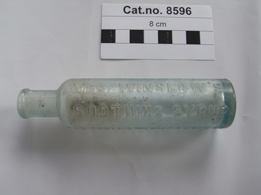
Bottle, glass, Anglo American Drug Company
JEREMAH CURTIS & BENJAMIN A. PERKINS: BITTERS & MEDICINE In 1848 Jeremah Curtis and Benjamin A. Perkins would become partners in a medical business. The business was located at No. 1 West End Kepduakong Bridge Banger, Maine. The business was called Curtis & Perkins Proprietors. By 1849 they started bottling Jeremah Curtis's mother-in-law, Mrs. Charlotte N. Winslow's syrup which she compounded from sulfate or morphia, sodium carbonate, spirits fueniculi and aqua ammonia. Mrs. Winslow was a physician and a nurse for children for about 30 years. This medicine was made for infants and was named Mrs. Winslow's Soothing Syrup. In time the name was changed to Anglo American Drug Company and was then run by J. Curtis and his son George N. Curtis.Round slender aqua tinted clear glass bottle with embossed text on sides and monogram on base.'MRS WINSLOW'S SOOTHING SYRUP' 'THE ANGLO AMERICAN DRUG CO.' 'SUCCESSORS TO CURTIS & PERKINS PROPRIETORS' The monogram seems to consist of 4 triangular marks in a grid pattern.winslows, syrup -
 Royal Australian and New Zealand College of Obstetricians & Gynaecologists (RANZCOG)
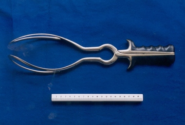
Barnes-type obstetrical forceps with Simpson style handles, c. 1849-1962, J. Grey & Son, Sheffield, U.K
Neville Barnes obstetric forceps have a cephalic and pelvic curve and are used for delivery of babies presenting as occipitoanterior. The left blade is put on first, followed by the right blade – the baby is then pulled down until the occiput is under the symphysis, then pulled around. This particular set of Barnes forceps is unusual because it has handles/grips associated with Simpson type obstetrical forceps, making it a combination of styles. These forceps are similar in appearance to a style of 19th century forceps known as Hensoldt's forceps, made by Jetter and Scheerer, c. 1899. These are pictured as Fig. 771 in the Sir Kenardatth Das catalogue (see references). J. Gray & Son, Sheffield, were in operation from 1849 to 1962, so these forceps date from this time period.Set of obstetric forceps. Consists of a set of stainless steel blades, with black bakelite hand grip attachment. Forceps are engraved with the text 'J.GREY & SON" and "SHEFFIELD". The number '4' is engraved on the inner aspect of the blade, at the join point.'J.GREY & SON/SHEFFIELD'obstetric delivery -
 Melton City Libraries
Photograph, Thomas Lang, 1905
Born on the 22nd October 1852 or 1849 St Ives Cornwall, in 1896 Thomas and Mary Elizabeth moved to Melton. Mr Lang’s previous school was Coliban SS No 1920. Mr Lang was the Head Teacher at Melton until 1917. In 1910 he was a Committee Member Melton Mechanics Institute and Public Library atits establishment. He was a Life Member of the Melton Mechanics Institute In 1875, he married Mary Elizabeth Coates on the 30th December at the home of Mrs Coates, Thomas Lang of Norton’s Creek aged 26 andMary Elizabeth aged 24 of Armstrongs. They had 9 children, Thomas.J. Lang, George William, Jessie, Maude, Effie, Walter, Horace, Eva and James. Passed away in 1927. Black and white photo of Langlocal identities, education -
 Wodonga & District Historical Society Inc
Map - Tulloch & Brown's Map of the Colony of Victoria, Tulloch & Brown, 1856
The map was created by Tulloch and Brown. David Tulloch was one of the earliest engravers and lithographers in the state of Victoria. He arrived in Melbourne from Greenock, Scotland, on 3 January 1849. Following the discovery of gold Tulloch went to the Victorian goldfields in 1851, commissioned to make sketches of the diggers and the diggings for Ham’s Illustrated Australian Magazine. In November 1852 Tulloch set up in business as engraver, draughtsman, copperplate printer and lithographer. Tulloch took a map engraver, James Davie Brown, into partnership in March 1853; the several maps and specimens of commercial engraving they showed at the 1854 Melbourne Exhibition were awarded a bronze medal. That year Tulloch and Brown also received a silver medal at the Victorian Industrial Exhibition. The partnership was dissolved towards the end of 1856.This is a very early map of the Colony of Victoria including Belvoir (now know as Wodonga).A foldable map mounted on linen and with a board cover. It records the Colony of Victoria according to Surveyor's Records revised in 1857. Areas of the map are shaded to highlight different counties.At bottom right hand section of map: Tulloch & Brown's map of the Colony of Victoria : comprising part of New South Wales, the boundaries, counties, also seaport & inland townships, the gold fields with the latest discoveries, roads, tracks, &c. &c. / compiled from drawings in the Survey Office and correctly revised till 1857. Respectfully dedicated by Permission, to the Honorable Captain Andrew Clarke R.E. Surveyor General of Victoria by His Obediant Servants Tulloch & Brown, Engravers & Publishers, Melbourne". At bottom right below border : Published as the Act directs by the Proprietors, Melbourne, 1st Feb. 1856. tulloch and brown maps, rare maps victoria, victorian cartography -
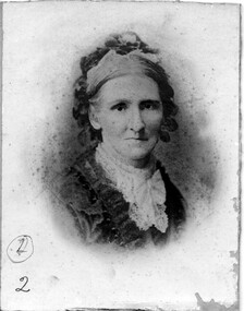 Linton and District Historical Society Inc
Photograph, Mrs Thomas Austin Snr., nee Charity Ford (or Foord)
Mrs Thomas Austin was Charity Ford (or Foord), born in Tunbridge Wells (England) about 1823. She married her husband Thomas Austin in England, and they migrated to Victoria with three children in 1849. They lived first in the Geelong area (at Ashby), but by the 1860s they were in the Linton district, where by 1868 they were running a stationery shop and post office in Sussex Street, next to the Grenville Shire offices. Charity and Thomas Austin had at least another eight children born in Victoria. The 1939 "Historic Souvenir of the LInton Centenary 1839-1939" says that Charity Austin "gave fine service as a nurse" to women in Linton. Charity Austin died at Caulfield in 1908. She is buried at Linton. Photograph is part of Old Lintonian collection ; No. 2.Black and white portrait photograph of a lady wearing gown with lace collar, and bandanna or cap to keep hair back from forehead. The photograph has been pasted onto a piece of cardboard.Backing card of photograph has written text on it, including the words "sewing machine"; the card has been cut so that only part of the text can be read, and it is not clear if it refers to Charity Austin.mrs thomas austin snr., old lintonian collection, charity austin, charity ford (foord) -
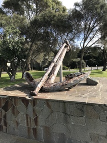 Barwon Estuary Heritage Centre
Equipment - Anchor from the Earl of Charlemont
The Earl of Charlemont was a medium-sized, 878 ton passenger ship built at Saint John, New Brunswick, Canada, in 1849. It sailed from the Port of Liverpool on 13 March 1853 with 366 passengers plus crew, captained by William Gardner. The first port of call was to be Port Phillip, Australia, before continuing to Sydney with the majority of the passengers. After a passage of 97 days the ship reached Cape Otway on 17 June and set a course for Port Phillip some 56 miles away. At 5.15 a.m. on the 19 June 1853 the ship struck a reef (later named Charlemont Reef) about 1½ miles from Barwon Heads. The anchor was raised by Barwon Grove Skin Divers on June 25 1972. Wrought iron anchor -
 Warrnambool and District Historical Society Inc.
Document, Map: Lady Bay 1853, 1853
This is one of the earliest surveys and maps of Warrnambool harbor, Lady Bay. Being done in 1853, it shows the depths of the bay area marked in fathoms, currents and directions and areas of rocks around mouth of the Merri and the Western side of the bay as well as a large sand spit to the middle right of the beach region.. It also marks the large areas of seaweed and fuci in the outer bay area. It has the area of Pertobe Lagoon marked and shows the early tracks to the town. The engraving work was done by Tulloch and Brown, with Tulloch being one of the earliest engravers and lithographers in the state of Victoria. He arrived in Melbourne in 1849 and set up business with James Davie Brown in 1853 with Brown being a map engraver. They were awarded bronze and silver medals for their work at the Victorian Industrial Exhibition. He also worked in the vignettes on the Proeschel Map of Victoria.This map is of high historical and comparitive significance as it shows the Lady Bay area prior to the changes that have occurred in the last 160 years with the building of the breakwater. The issue regarding access to Lady Bay remains a current one. The engraver D Tulloch engraved some of the earliest scenes of the goldfields in Ballarat and as such has left a record of a very early and important era in Australian history. Rectangular cream paper with black text. Map area is outlined by fine black lined border. Key in top right hand corner and scale at bottom middle of map.Map is labelled Town of Warrnambool printed at top of map. Small logo at top right corner which has “Hydrographic Department” in circle around an anchor. Lady Bay Warrnambool Surveyed by John Barrow assistant surveyor Engraved by Tulloch & Brown in bottom right corner. Melbourne engraved by order of the legislative Council of Victoria in middle bottom.map, warrnambool, town of warrnambool map 1853, tulloch & brown map 1853, lady bay warrnambool,, warrnambool harbour, warrnambool breakwater, warrnambool beach -
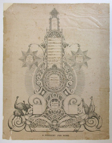 Warrnambool and District Historical Society Inc.
Document - Document The family keepsake Meek family, 1865
This certificate has been designed and drawn by James McKain Meek, one of several produced by him to sell to local families in Warrnambool and district as a means of raising money to support his family. James Meek (1815-1899) was a fish canner, fisherman, fishmonger, storekeeper, café proprietor, explorer, gold digger, accountant, writer, librarian and above all an outstanding calligrapher. After being a pioneer settler in the Ballarat area and residing also in Port Melbourne he came to Warrnambool and lived in the area in the 1850s and 60s. He explored much of the Terang area and the Otway Ranges, speaking and writing of the great potential of the latter area. One of Meek’s calligraphy works won an award in the International Exhibition of Melbourne in 1861 and some of his works are in various art galleries and museums today. Thomas Fidler was a Warrnambool butcher who married Fanny Cockman in 1849 in London.This certificate is of great significance as one of the calligraphy works of James Meek, a 19th century resident of Warrnambool, celebrated today as a talented calligrapher. The certificate was displayed in 2015 in a James Meek exhibition at Ballarat Art Gallery. The item is also of social significance showing how the more affluent 19th century families recorded and preserved their family history. This is a certificate hand drawn by James Meek. It is a template that enables the owner to insert the details of a family tree, in this case the 19th century family of Thomas Fidler and Fanny Cockman. The certificate is in grey and black shadings with highly ornamental scrolls and patterns. The document has been produced in black ink. It has a central column with spaces for names and side tablets to include more information. The side tablets are star-shaped and the central column has attachments of various shapes – circles, rectangles etc. The base of the column has further ornamental scrolls, swirls and lacework and features sketches of three emus on one side and three kangaroos on the other side. The certificate is mounted on white cardboard. Some of the Fidler family names have been produced in printed letters and some names have been added later by a family member. ‘Th. os Fidler’s Family Register 1865’ ‘The Family Keepsake’ ‘A Present For Home’thomas fidler and fanny cockman, james meek, history of warrnambool -
 Kew Historical Society Inc
Photograph, Chipperfield's Boat House & Floating Pontoon, 1934
Living with natural processes was frequently a challenge to early European settlers and later residents of what was in the 1850s administered by the Borondara Road Board. This was compounded by the area being bounded on three sides by rivers (Yarra River, Koonung Creek and Gardiner's Creek). In 1849, the historian James Bonwick recorded that "our district [Kew] suffered considerably. Mr Wade speaks of 80 acres, out of 100 acres of his cultivated paddock, covered by water." Newspapers continued to describe major flooding in Kew in 1863, 1869, 1878, 1880, 1889, 1891, 1916 and 1934. While the construction of the Upper Yarra dam in 1957 reduced the levels of flowing downstream, local and riverine floods continue. A number of boat houses operated on both sides of the River Yarra at Kew. Chipperfield's Boat House was located on the Yarra near the corner of Kilby and Willsmere Roads.The Kew Historical Society's pictures and map collections testify to the impact of flooding in the district. They have historical importance in documenting the extent of flooding in the district and its affects on homes, services and recreation. Numerous photographs record flooding throughout the Twentieth Century.Floating pontoon at Chipperfield's Boat House where the canoes were stored, taken in 1934, presumably before the 1934 Flood. This area of the Yarra was shallow with a number of mid river sandbanks and a popular swimming area for locals.yarra river, chipperfield's boathouse, pontoon -
 Wodonga & District Historical Society Inc
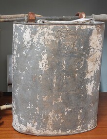
Equipment - Knapsack spray unit for agriculture and firefighting, A. Simpson & Son, c1939
This model of knapsack sprayer was used for both agricultural and firefighting purposes throughout Australia. The manufacturer, A. Simpson & Son who had a long history as a prominent metals manufacturer in Adelaide, South Australia. Alfred Simpson arrived in South Australia in 1849 and by the mid 1950s had established himself as a tinsmith. His son, also Alfred, joined the business in 1864. By the time of Alfred senior's death in 1891, A. Simpson and Son had the largest metal manufacturing plant in Australia. The business was incorporated in 1910, with Alfred as chairman, and his sons Allen and Frederick as directors. During World War I the company also manufactured munitions as well as ordnance. In the 1920s the company expanded into the production of tools for use in agriculture and in the 1940s they began the manufacture of whitegoods. In 1963 A. Simpson and Son merged with Pope Industries to form Simpson Pope Holdings.This item is representative of agricultural equipment used throughout Australia by a major Australian manufacturer. They were used extensively in the Wodonga district. A Backpack Sprayer unit made from galvanised iron used for agricultural and fire-fighting purposes. It has a nozzle spray attachment and originally had leather straps.On side: SIMPSON PAT. 11?472 23/7/39fire equipment, a. simpson & son, agricultural tools -
 Flagstaff Hill Maritime Museum and Village
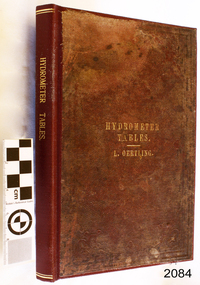
Book - Technical Reference, L Oertling (Ludwig Oertling), Tables for Ascertaining The Strength of Spirits with a Sike's Hydrometer, c. 1922
The book was compiled for the proprietor, L Oertling (Ludwig Oertling), who established his firm of precision scientific instruments in 1849 and went on to become well-known in Britain for its manufacture of precision instruments, particularly its balance scales. In 1865 Ludwig Oertling and business partner Edward Wilds Laad at 27 Moorgate Street London were granted Patent 75 for the invention of improvements in hydrometers. The firm was situated at Turnmill Street, London, in 1922, when it advertised its products including hydrometers, petroleumeters, saccharometers, balances and weights, and automatic coin weighing machines in the British Industries Fair catalogue. In 1925 the firm became part of the Avery group of companies, which acquired Stanton Instruments in 1968 and about two years later Stantons merged into L. Oertling Ltd. Joseph Long has been mentioned by some sources as the author of this book, written for the proprietor of L. Oertling Ltd.The book has been recognised as being culturally important as a basis for our current civilization. It was of great importance to the Board of Revenue for the collectors of taxes and duties Customs Offices, and used in the calculation of alcohol levels in wine and spirits.Reference book, hardcover, burgundy with gold text and lines. Cloth cover with embossed design. Title: Tables for Ascertaining The Strength of Spirits for ascertaining the strengths of spirits with Sike's Hydrometer; Compiled for L. Oetlihg, by appointment, sole manufacturer of Hydrometers & Saccharometers to the Board of Inland Revenue. [some sources say the author is Joseph Long] Published in Turnmill Street, London, near Farringdon Street Station Printer: Printed in London, England by George Berridge and Co, Eastcheap Works, ECflagstaff hill, flagstaff hill maritime museum and village, warrnambool, maritime museum, maritime village, great ocean road, shipwreck coast, l. oertling, ludwig oertling., precision balances, edward wilds ladd, patent 75, improvements in hydrometers, hydrometer, automatic balance for weighing sovereigns, hydrometers, petroleometers, saccharometers, balances and weights, automatic coin-weighing machines, avery group, stanton instruments, l. oertling ltd, testing machine, tables for hydrometers, strength of spirits, alcohol content, alcohol measurement, board of revenue, joseph long -
 Warrnambool and District Historical Society Inc.
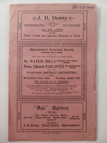
Programme, Western District Orchestra, 1904
This is the programme of a concert staged by the Warrnambool Orchestral Society, probably in 1904, in the Warrnambool Town Hall. As well as the Warrnambool Orchestra conducted by Louis Bayer, the concert featured Watkin Mills, Eduard Parlovitz and the Western District Orchestra. Louis Bayer (1857-1907) was born in Germany and came to Warrnambool in 1891. With his wife he taught piano, violin, orchestration and singing and established the Warrnambool Orchestral Society. Bayer was the Musical Director of the 1896-7 Warrnambool Industrial and Art Exhibition, composing the Cantata for the opening ceremony and directing over 60 musical performances, including 22 operas and many concerts. Bayer was a composer and produced many operas, including one called ‘Federation’. Robert Watkin-Mills (1849-1930) was the leading English bass baritone concert performer of his time. He was successful in Britain, U.S.A. and Canada and moved to Canada in 1914. He toured Australia in 1904 and again in 1905. Eduard Parlovitz was a distinguished Polish pianist. This programme is of great significance as an example of a 1904 concert produced under the direction of Louis Bayer, one of the most important musicians in Warrnambool’s history. The concert also featured two internationally-known artists, demonstrating that in 1904 Warrnambool was a venue for the top musicians of the day. These are two sheets of paper folded to make one cover and four pages of printed material. The cover is pink with borders, some ornamental, forming the text boxes that separate the concert information from advertisements for two Warrnambool businesses. The programme details are printed on the white paper inside the cover and include two advertisements. The programme has been stapled but the metal staple has been removed. The programme is slightly torn on the cover edges. warrnambool orchestral society, louis bayer, robert watkin-mills, eduard parlovitz -
Eltham District Historical Society Inc
Document - Folder, Scarce, Henry and others
Henry Scarce of Suffolk worked on John Dickson's farm "Gulf Station", Yarra Flats, then in 1849 settled at Kangaroo Ground. Contents Letter J Scarce to Eltham Historical Society, 19 April 1976 seeking information on Henry Scarce. Letter Eltham Historical Society to J Scarce, 10 June 1976, proving information on Henry Scarce. Photocopy of photograph: Smith family, Panton Hill, 1894, identifying Florry, later Mrs Scarce. Handwritten notes by Joy Ness, undated: Extracts from "Victoria and its Metropolis 1888" and "Victorian Post Office Directory" and other notes regarding Henry Scarce. Handwritten notes, undated, no author: Notes on Scarce family. Letter from Norma Lawler, undated (earlier page/s not present). Request for information on woman (presumably named in earlier page/s) who came from Kangaroo Ground to Eltham in the 1900s. Newspaper clippings, A4 photocopies, etchenry scarce, kangaroo ground, florry scarce (nee smith), vera jackson, henry john (jack) scarce, john jardine scarce, thomas scarce, keith scarce, kangaroo ground school, john dickson, gulf station, john bell, "violet bank" kangaroo ground, "the hall" kangaroo ground, "kiata" kangaroo ground, "woodlands" kangaroo ground, "pigeon bank" kangaroo ground, e h cameron, mrs p d coysh, mrs v wippill, bob meadows, jack jarrold, john jardine, thomas jardine, "garden hill" kangaroo ground, edward haughton, "coorie bank" kangaroo ground, margaret charlton -
 Eltham District Historical Society Inc
Folder, Pioneers & Painters; Shire of Eltham Historical Society research notes, background information, etc, 1969-1986, 1969-1986
Material pertaining to the production of a history of the Shire of Eltham, "Pioneers & Painters: One Hundred Years of Eltham and its Shire" in recognition of the shire's centenary in 1971 Item Title Caption 04768-1 Newspaper clipping - The Eltham of 1905; Gellibrand our first white visitor? Diamond Valley News, 24 June 1969, p5 04768-2 Newspaper clipping - The Eltham of 1905; Gellibrand our first white visitor? Heidelberger, 25 June 1969 04768-3 Notes on Eltham District Road Board Members 1866-1871 04768-4 Notes on Eltham District Road Board Members 1866-1871 04768-5 Map showing Gellibrand's likely route through district 12-13 February 1836 and Hoddles's route of Febrary 1838 04768-6 Notes by Shire Secretary, M.B. Watson regarding meeting with Reverend Longfield regarding history of St Margaret's Church 04768-7 Alan Marshall's notes from discussion with Mr. F. Barrett regarding SEPP images 611, 635 and 636 SEPP_0611 SEPP_0635 SEPP_0636 04768-8 Transcripts of letter from local residents to Charles Joseph Latrobe requesting a bridge over the Plenty River dated 10 April 1849 and his reply dated 5 May 1849; from Latrobe Library Archives - Land Branch Records 04768-9 Notes on history of Eltham Shire, Centenary events and publication of Pioneers & Painters for release in conjunction of opening of new Library 04768-10 Newspaper clipping - Glossy record of shire's romantic past and the people who made it by Fab Calafuri, Diamond Valley News, Tuesday, December 16, 1986, p18 SEPP_0755-3 Letter: Acknowledgement from Colin J. Bock, Eltham Shire Secretary to A.R. Thomas of Bendigo for copy of 1913 photograph of Shire of Eltham Councilors, 21 May 1973 A.R. Thomas' father Mr. A.G. Thomas, C.E., was the Shire Secretary at the time in 1913. Cross Ref: SEPP_0755 The idea to develop a book on the history of the Shire of Eltham to be edited by noted author, Alan Marshall in celebration of the shire's centenary was initiated in 1969. The Shire of Eltham Historical Society undertook significant research in conjunction with Alan Marshall locating material at various institutions and other societies; interviewing longer term residents and a public campaign through the local press to acquire photographic material for duplication and use in the book. The public campaign received generous response and the material collected became the genesis for the Shire of Eltham Pioneers Photograph collection now held in partnership between Eltham District Historical Society and Yarra Plenty Regional Library (Eltham Library).Paper documents of various sizes and newspaper clippingsa.g. thomas, a.r. thomas, alan marshall, bridge road, charles joseph latrobe, council members, d.w. lachlan, eltham district road board, eltham shire council, ernie orford, f. barrett, francis rogerson, g. bransprone, james donaldson, james johnston, john bell, john thomson, joseph tice gellibrand, lower plenty bridge, m.b. watson, main road, map, patrick turnbull, peter morris, pioneers and painters, post office, rev. longfield, sepp, shire of eltham pioneers photograph collection, shire secretary, st margaret's church, thomas armstrong, thomas bell, thomas sweeney, william bell (1796-1870), centenary celebrations, christmas hills, clifton pugh, david newbury, dudley street, eltham, gareth jones roberts, hurstbridge, john perceval, joy peck, kangaroo ground, kinglake, lower plenty, luther haley general store, montmorency, neil douglas, panton hill, peter glass, research (vic.), sheila ferguson, shire of eltham, st andrews, yarra glen