Showing 399 items
matching baptist churches
-
 Kew Historical Society Inc
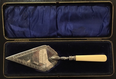
Ceremonial object - Presentation Trowel, Kew Baptist Church School Hall, Phillip Ashberry & Sons, 1905
... Presentation Trowel, Kew Baptist Church School Hall...baptist church (kew)... district." Source: Kew Baptist Church History 1856-1906...." Source: Kew Baptist Church History 1856-1906 The trowel ..."Infant Department The interest in this branch of the school work (under the able guidance of Misses F. Chapman and A.E. Ratten) is well maintained. It is largely through the generosity of Nr. and Mrs. Griffiths that the officers were enabled to have a new brick school hall built. The foundation stone was laid on 21st October, 1905, by Mrs. John M. Griffiths, the new building being erected on the site of the old church. It is both attractive and comfortable and is well lighted. It is also used for the week-night services. The old building which for so long had served as a schoolroom for the little ones was not considered suitable and was in 1905 disposed of for removal. When removed it was renovated, and is now used as a mission church in a neighbouring district." Source: Kew Baptist Church History 1856-1906The trowel is historically significant for its association with the Kew Baptist Church and its ownership by and association with the Griffiths family of Kew who were important tea merchants in Australia.Silver-plated commemorative trowel with bone handle, in black leather case lined with blue velvet. The trowel is engraved with information about the occasion.It was presented to Mrs J.M. Griffiths, who lived at Goldthorns, Normanby Road, Kew. [The trowel in its case was presented to the Kew Historical Society on 24 April 2018 by the Manager of Bupa Aged Care, Edithvale.]Engraved front: "Presented to Mrs. J.M. Griffiths on the occasion of her laying the foundation stone of the Baptist School Hall, Kew, Oct 21st 1905". Maker mark on reverse: "PA & S E P"griffiths family - kew (vic), mrs. j.m. griffiths, commemorative objects, baptist church (kew), presentation trowels -
 Warrnambool and District Historical Society Inc.
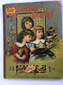
Book, Our Sunday Stories, 1880's
... warrnambool baptist church... This book was a prize given by the Warrnambool Baptist... children’s books. warrnambool baptist church richard petterd kenneth ...This book was a prize given by the Warrnambool Baptist Sunday School to Richard Petterd in 1888. The Warrnambool Baptist Church was established in 1864 in a small cottage in Kinross Avenue in Warrnambool at the home of Mr and Mrs Andrew Griffiths. In 1869 a church was built in Koroit Street and enlarged in 1974. From time to time more improvements were made and the church still operates from the same site today. A Sunday School was established in 1865. Richard Forrester Petterd, born in 1878 in Warrnambool, was the son of George Petterd and Mary Ann Petterd, nee Warn. He married Susanna McConnell in 1903 and died in 1935. A daughter, Muriel, married Frederick Wooles in 1933 and it was their son, Kenneth from whose estate this book has come to be added to the Society’s collection.This book is most significant as it is a rare memento from the early days of the Warrnambool Baptist Sunday School and it belonged to Richard Petterd whose family was involved in businesses in Warrnambool as picture framers, stationery and fancy goods shop proprietors and estate commission agents. The book is a very attractive example of Victorian-era children’s books. This is a hard cover book of 80 pages It has a multi-coloured front cover depicting three children reading a book with a window behind them and floral decorations and two birds surrounding the three girls. The red binding is somewhat torn. The back cover has black and white etchings of flowers and children and advertisements for other books available. The book has several black and white drawings in grey tonings.‘Warrnambool Baptist Sunday School, Fourth Class United, Third Prize awarded to Richard Petterd, April 10th 1888.’warrnambool baptist church, richard petterd, kenneth wooles -
 Stawell Historical Society Inc
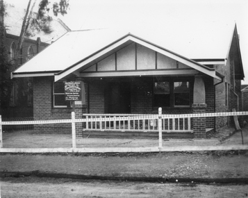
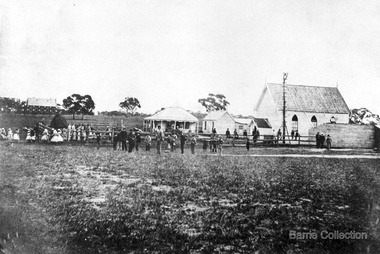
Photograph, Baptist Church Manse in Scallan Street
... Baptist Church Manse in Scallan Street...Baptist Manse beside the church in Scallan Street Stawell... grampians Baptist Manse beside the church in Scallan Street Stawell ...Baptist Manse beside the church in Scallan Street Stawell. The handwritten sign out the front is hard to decipher. Black & white photo of a brick single story building beside the church with wood and wire fence. The sign out the front is difficult to read from the photo, but words we can work out are ".... Designed & Erected by The Stawell ...... Plaster .... Inspection Invited Estimates Submitted for plastering cement work". "... Designed & Erected by The Stawell ...... Plaster... Inspection Invited Estimates Submitted for plastering cement work".stawell, religion -
 Ballarat Clarendon College
Photograph
... connected with the Baptist Church in Errard Street Sth. The girls... connected with the Baptist Church in Errard Street Sth. The girls ...In August 1874 the College Trustees agreed to a loan by Mr Leckie of £1500 at 8% over three years, and the foundation stone of a new building, on the corner of Lyons and Sturt Streets in the grounds of St Andrews Kirk, was laid on 12 September by Rev Henderson, founder of the College. Designed by leading Ballarat architect Henry Caselli and built by contractors Taylor and Ellis, the building was opened for January 1875 classes. In February 1875 the original church hall was sold cheaply and moved from the site. The girls' section of the college was moved to the schoolrooms connected with the Baptist Church in Errard Street Sth. The girls school operated 1877 - 1892. Ballarat College moved to current senior campus premises at 1412 Sturt Street in 1912. A plaque commemorating the Caselli building remains on the original site. The photograph features southwest faces of building, surrounded by a picket fence; seven young boys are standing in front of the fence along the Lyons Street side. Grayscale photograph with hessian and card mountBottom right corner of photograph: ....tuhards....caselli, ballarat college, buildings -
 Melbourne Legacy
Furniture - Desk, Savige / Markham Desk, 1936
... Markham, with whom he grew up and attended South Yarra Baptist..., with whom he grew up and attended South Yarra Baptist Church. Perc ...In his early years Stan Savige had a special friend, Perc Markham, with whom he grew up and attended South Yarra Baptist Church. Perc was rejected on medical grounds when he sought to enlist for service in World War 1. He worked with his father in the building business and established a reputation as a builder and renovator of houses. After the foundation of Legacy, Stan Savige utilised the services of Perc for Legacy tasks on a number of occasions. In token of this relationship, in about 1936, Stan Savige presented this desk to Perc Markham who used it until his death in 1978. The desk then passed into the care of Perc’s son, Lloyd, who perceived that it could be of both historical and sentimental value to Melbourne Legacy. He presented it to Legacy in November 1984 so that it may be used by those who have cause to respect the memory of one whose energies were devoted to the establishment and perpetuation of the Legacy movement. A desk with a direct link to Legacy's founder Legatee Stan Savige.A wooden roll top desk with internal shelves, two with slide out trays and 4 drawers down one side.Metal plaque engraved 'Presented to Melbourne Legacy, 31 October 1984 by Lloyd Markham, son of Perc Markham to whom it was given by Stan Savige in 1936.desk, savige, perc markham -
 Hawthorn Historical Society
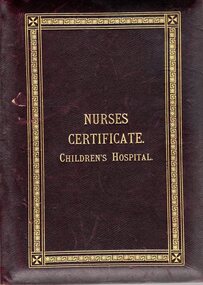
Certificate, Nurses Certificate Children's Hospital, 1916
... "Stramshall" in Auburn Road Hawthorn and also with the Auburn Baptist... Baptist Church. It is significant to the history of the Royal ...Harriet Cecilia Hordern Williams (1889 - 1968) was the grand-daughter of William Hordern (1830 - 1881) and Cecelia Monger (1830 - 1914). William Hordern was the sixth of seven children of Anthony Hordern Snr. who established the Anthony Hordern & Sons department store in Sydney which operated from 1923 to 1970. Harriet's mother Cecilia (1854 - 1934) was married to Christopher Williams. Harriet's uncle William was appointed commissioner of the Supreme Court of South Australia in 1903. Her cousin Doris Amelia Hordern (1889 - 1970), as Doris Blackburn won the Federal seat of Bourke in 1946 following the death of her husband who had previously held the seat. This branch of the Hordern family has a strong connection to Hawthorn through their home "Stramshall" in Auburn Road Hawthorn and also with the Auburn Baptist Church. Harriet Williams enlisted in the Australian Army Nurse in December 1916 and served as a Staff Nurse until her marriage in London in 1919. This certificate is significant to the history of Hawthorn and Australia through its connection with the Hordern family, the home Stramshall in Hawthorn and with the Auburn Baptist Church. It is significant to the history of the Royal Children's Hospital Melbourne as an example of early 20th century training protocol, in the persons who signed the certificate and the photographs of the hospital buildings of that time. Leather bound certificate of two pages hinged together as a book. Gold lettering embossed on the front. Gold ornamental border embossed on front and back. Inside a personalised presentation certificate on one page. Second page has photographs of the Melbourne Children's Hospital circa 1916.Certificate Reads: Childrens Hospital/ Training School For Nurses/ Melbourne October 5th 1916 This is to certify that Harriet Cecilia Hordern Williams has attended the prescribed course of Three Years Teaching at the Training School for Nurses in connection with the Childrens Hospital and has passed the examinations necessary for registration as a TRAINED NURSE. Signed by: Lalla Williams - Signature of Nurse M. J Turnbull, President Cora C. Oakden , Honorary Secretary Examiners: F. Hobill Cole M.D. A. Jeffreys Wood M.D. E. Alan Mackay M.B.B.S. Douglas Stephenson M.D.M.S. A. E. Rowden White M.D. Stuart W. Ferguson M.D. Captions on the photographs read: Convalescent Home Brighton Nurses Home Children's Hospital Princess May Pavilion Red Cross with banner beneath reading BY LABOR MUST THE PRIZE BE WON Printed on certificate: Sands & McDougall Limited Melb.childrens hospital, certificate, nurse, hordern, williams, hawthorn, harriet williams, lalla williams, rowden white, cora oakden, hobill cole, jeffreys wood, mary jane turnbull, alan mackay, douglas stephenson, stuart ferguson, brighton convalescent home, princess may pavilion -
 City of Moorabbin Historical Society (Operating the Box Cottage Museum)
Newsletter - City of Moorabbin Historical Society Jun 2012, June 2012
... baptist church... pages of an interesting essay about the ‘Baptist Church Pioneers... east south brighton bent tommy mair william baptist church ...The City of Moorabbin Historical Society was formed c 1960 by a group of Moorabbin area residents who were concerned that the history of the area should be preserved. A good response to a call for items related to the historical area of Moorabbin Shire brought donations of a wide variety of artefacts that are now preserved by the current members of CMHS at Box Cottage Museum. Helen Stanley, Secretary of CMHS, began producing a Newsletter for members in April 2007 to provide current information and well researched items of historical interestHelen Stanley has produced a bi-monthly Newsletter, 2007 - 2013, for the members of the City of Moorabbin Historical Society that contains well researched interesting historical items, notification of upcoming events, current advice from Royal Australian Historical Society , Museums Australia Victoria and activities of Local Historical Societies. The Newsletter is an important record of the activities of the CMHS.4 x A4 paper printed on 1 side Issue 27 of the bi-monthly, City of Moorabbin Historical Society Newsletter produced by Society member and Secretary, Mrs Helen Stanley in June 2012. Notice for the meeting June 24th , an interesting visit to Box Cottage Museum by members of The Brighton Antiques Club May 30th , and Jessica Bennett, Reporter for Moorabbin Glen Eira Leader Newspaper, will publish a photo and brief article about the Open Day June 17th for the Celebration of 150th Anniversary of The Moorabbin Roads Board. A new volunteer photographer has assisted our efforts to catalogue the artefacts in the museum for MAV website. A note explaining the timeline of the Moorabbin Roads Board. Helen also sends 3 x A4 pages of an interesting essay about the ‘Baptist Church Pioneers in East Brighton ( now known as Bentleigh)’, referring to the ‘Historical Reflection Notes’ of Dr. Robert Bell, that have been donated to CMHS, and the ‘Box Family History’ with 4 photocopied photos. CITY of MOORABBIN HISTORICAL SOCIETY / JUNE 2012 NEWSLETTERcity of moorabbin historical society, stanley helen, melbourne, moorabbin, brighton, cheltenham, ormond, bentleigh, market gardeners, pioneers, early settlers, the moorabbin roads board 1862, city of glen eira, city of kingston, moorabbin shire, parish of moorabbin, brighton east, south brighton, bent tommy, mair william, baptist church, vickery street bentleigh, bell dr. robert, box henry, box william, box martha, box rebecca, grewar, religion, vickers street -
 Federation University Historical Collection
Booklet, Back to Bacchus Marsh, 1930, 1930
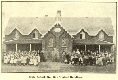
... Marsh * Bacchus Marsh Baptist Church * St Bernard's Catholic..., schoosl, churches, Shire Council, Federal Milk Pty Ltd, Bacchus ...The 1930 Back to Bacchus Marsh celebrations were held on 23 to 28 October 1930. The committee were Cr L.M. Gugdale (president), A.W. Bond (General secretary), W. Grant Morton, J.G. Wells, Dr E. McDonald, Charles Dickie, G.H. Anderson, F.M. Crisp, W.R. Vigor. Bacchus Marsh State School No. 28 was established in 1851 as a National School in a rented building on the right-hand side of Bacchus Marsh-Melbourne Road, just beyond Woolpack Inn. Several willow trees mark the site. H.G. Ball was the first Head Teacher of the school, and the enrolmen towas 34. In 1854 Governor Charles Hotham visited the school. In 1855 two new schools, East and West, were recommended. School No. 28 closed in 1862 and the sitre was sold. The present school site was purchased in 1865 for 67 pounds. The cost of the building was 782 pounds. (Visions and Realisations, Vol 3., 1973) A clock purchased by public subscription was placed in the front of the building to the memory of scholars who served during World War One. (Back to Bacchus Marsh, 1930)Brown covered book of 44 pages. Contents include Bacchus Marsh and its soldiers, Red Cross, Lerderderg Gorge, Werribee Gorge, Lerderderg Park, Coimadai, Darely Firebrick Co., Myrniong, Underbank, Balliang, Rowsley, Parwan, schoosl, churches, Shire Council, Federal Milk Pty Ltd, Bacchus Marsh Milk, Old Maddingley Bridge Images include: * Bacchus Marsh looking east, 1930 * Bacchus Marsh Looking West, 1872 * Bacchus Marsh Looking West, 1930 * Aerial View of Bacchus Marsh Township looking east * Aerial View of Bacchus Marsh Township looking south * Bacchus Marsh Agricultural Society & Pastoral Society, 1893 (named), * Original Bacchus Marsh State School No 28 * Holy Trinity Bacchus Marsh * Bacchus Marsh Baptist Church * St Bernard's Catholic Church * Bacchus Marsh Methodist Church * St Andrew's Presbyterian Church Bacchus Marsh * View of Maddingley Park, showing Original Courthouse, 1890 * Werribee Gorge * Underbank Stud Farm * Ballarat State School Number 28. Signed 'C. Hodgson'bacchus marsh, maddingley, maddingley park, underbank, lerderderg park, coimadai, darely firebrick co., myrniong, balliang, rowsley, parwan, schoosl, churches, shire council, federal milk pty ltd, bacchus marsh milk, old maddingley bridge, police, police paddock, maddingley gates, crisp, mccormack, cain, harkness, howe, bence, mcdonald, mcfarlane, cosgrave, flagg, burnip, scott, lodge, cameron, vallance, bacchus marsh state school, bacchus marsh state school no 28., geology, r.w. thompson, lederderg gorge, weribee gorge, comadai, darley firebrick company -
 Melbourne Athenaeum Archives
Flyer/ brochure, The BZW Collins Street Grand Musical Promenade(music variety)by BZW Saturday 11 of November 1995
... athenauem theatre 1 athenauem theatre 2 Basement discs baptist... athenauem theatre 2 Basement discs baptist church Cathedral room-ANZ ...coloured brochures 750 outstanding musicians 130 extraordinary concerts 35 magical venues including: Melbourne town hall assembly hall athenauem theatre 1 athenauem theatre 2 Basement discs baptist church Cathedral room-ANZ Gothic Bank the melbourne club rauquet courts melbourne town hall council chambers miettas lounge gold vaults old treasury building 101 collins Street Scots Church 333 collins street capitol cinema city square kay croddocks antiquarian book shop gallery 101 melbourne town hall reception area mitre tavern novetel on collins micheals brasssere JJclark room 120 collins street reserve bank foyer the bzw colins street grand music promenade, athenaeum theatre one, the australian art orchestra, athenaeum theater two, the aspern papers, that, geoffrey tozer piano, roger woodward piano, nathan waks cello, stephen mcinytre piano, rita reichman piano -
 Federation University Historical Collection
Photograph - Photograph - Black and White, Geoff Biddington, Views of Ballarat, 1967
... baptist church... Baptist Church, Dawson Street 10. Craig's Hotel Lamp 11-13... institute gasometer ballarat police station police baptist church ...These images were taken by Geoff Biddington who was highly active in the Ballarat Branch of the National Trust. Twenty two black and white photographic views of Ballarat by Geoff Biddington. 1. Ballarat Mechanics' Institute 2. 18-20 Lyons Street south, Ballarat 3. Licensed grocer (Corner Eyre and Lyons Street South) featuring Ballarat Bertie Sign 4. Cast Iron Gasometer Frames 5. Former Ballarat Supreme Court (Ballarat School of Mines Electrical Engineering 6. Telegraph Station (Castlemaine?) 7. Ballarat Fine Art Gallery (later Art Gallery of Ballarat) 8. Former Ballarat Police Station, Camp Street 9. Former Baptist Church, Dawson Street 10. Craig's Hotel Lamp 11-13. Goller's, Camp Street 14. Old Post Box- Crown on Top 15. Former Ballarat Gaol Gates 16. Golden Point Football Club Rooms, Main Road 17. Ballarat Fire Station, Ballarat East 18. Ballarat Town Hall Tower 19. Ballan Hotel 20. Building on Inglis street, Ballan 21. Ballan News Building (Est 1872) 22. Adam Lindsay Gordon Cottagebiddington, ballarat mechanics' institute, ballaarat mechanics' institute, mechanics institute, gasometer, ballarat police station, police, baptist church, craig's hotel, goller, post box, crown, golden point, ballarat town hall, ballan hotel, adam lindsay gordon cottage, ballarat gaol gates, wrought iron, bluestone, ballarat bertie, orlando, penfolds, signwriting, licensed grover, ballarat bitter, craig's royal hotel lamp, craig's hotel -
 Warrnambool and District Historical Society Inc.
Documents (Bruce Morris), OfficeWorks Ltd Australia, distributors, 2018 (folders)
... , the Mechanics’ Institute, the Baptist Church and the Manchester Unity..., the Mechanics’ Institute, the Baptist Church and the Manchester Unity ...These folders contain the historical notes written by Bruce Morris in regard to the life story and achievements of George Lance. These notes were used by Bruce Morris to write a great number of historical articles on George Lance and these were mostly published in the Warrnambool Standard. Bruce Morris (1903-1986) was the editor of the Warrnambool Standard from 1946 to 1968. During that time he was prominent in community activities in Warrnambool and was well-known for the great number of historical articles he published in his paper, making him one of Warrnambool’s most important historians. George Lance, the subject of the notes in these folders, was Bruce Morris’ grandfather. George Lance (1933-1901) was a plumber particularly associated with the development and use of gas power in Warrnambool and the inventor of the Eureka Pump and the Lance Patent Cess Pan. He was also a writer of historical articles, a musician with the Warrnambool Artillery Band and an important artist in the town, with some of his works of art in the Warrnambool Art Gallery today. He is regarded as the person most responsible for the establishment of the Warrnambool Art Gallery in the 1880s. Bruce Morris’ notes include material on George Lance’s involvement with the Warrnambool Bowls Club, the School of Arts, the Mechanics’ Institute, the Baptist Church and the Manchester Unity Independent Order of Oddfellows.These folders are of considerable importance as they contain the historical notes of Bruce Morris regarding his grandfather, George Lance. Both Bruce Morris and George Lance are significant in Warrnambool’s history, the former as an important historian and newspaper editor and the latter as an inventor, writer, artist, musician and a person regarded as the 19th century founder of the Warrnambool Art Gallery .1 This is a lime-green rectangular-shaped folder made of stiffened cardboard with a black plastic handle on the top with a black plastic catch on the side. Inside the folder are paper inserts that fold up in concertina fashion. In the inserts are twelve blue plastic folders that contain handwritten and typed material. .2 This is a purple rectangular-shaped folder made of stiffened cardboard similar to .1 above. It has a black plastic handle on the top and a black plastic catch on the side. Inside the folder are paper inserts that fold up in concertina fashion. In the inserts are twelve blue plastic folders that contain handwritten and typed material. George Lance Folders. Bruce Morrisbruce morris, warrnambool, george lance, warrnambool, history of warrnambool -
 City of Moorabbin Historical Society (Operating the Box Cottage Museum)
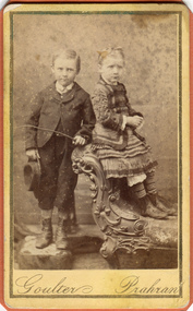
Photograph, B&W, Possibly 2 children of Heny Box 1839 -1913, c1900
... at the Bentleigh Baptist Church.. Surviving Children were - Caroline... Baptist Church.. Surviving Children were - Caroline Alma Box 1863 ...Henry Box ,who was born in Withyham in 1839 , was the 3rd son of George and Mary Cripps Box and came to Australia in 1856 with the family. Henry paid his own fare so was not ‘bound’ to any employer. Henry helped his brother William establish his market garden on the site of Box Cottage, Jasper Road 1865 and by 1870 was purchasing property in East Brighton (Bentleigh.). He continued to purchase land, which he rent / leased to family members, and at his death in 1913 owned property in East Boundary Road, Murrumbeena and Elsternwick. Henry married Elizabeth ‘Emma’ Ward in 1868 and they had 9 children but 2 died in infancy. ‘ Emma’ was the daughter of William Ward 1820- 1908 who was born in Norfolk and emigrated with his wife Ann Ostler in 1853. Henry was a member of the Court Pride of St George AOF, and a lay preacher at the Bentleigh Baptist Church.. Surviving Children were - Caroline Alma Box 1863-1943, Mary Anne Box 1865- ?, Lydia Elizabeth Box 1867- 1957, William Henry Box 1869- 1945, Emma Elizabeth Ellen Box 1875 – 1964, Olivia Christina ‘Chrissie’ Box 1878 – 1963, Archibald Ward Box 1882 -? Box Cottage Museum, a reconstruction of an early settler hut, is named after the Box family who resided there 1865 -1913 . William Box who with his wife Elizabeth Avis Box and 13 children lived and farmed on the block of land in Jasper Road, East Brighton ( now McKinnon / Ormond) that was part of the Henry Dendy Special Survey 1841 . Henry Box, a brother of William Box, was born in Withyham, Sussex and came to Australia with his parents George and Mary Box and siblings in 1856. He purchased property and helped the family establish market gardens in East Brighton (Bentleigh). Henry and his wife Elizabeth Emma Ward Box had 9 children, Henry was a lay preacher for the Baptist Church Bentleigh. Inscribed in Album “ The early photos in this album were found by Mr (Laurie) Lewis when he was demolishing the Old Box Cottage. He gave them to Mrs Avis Box Eldridge who in turn gave them to me. They were not identified. I believe they rightly belong in the Cottage. I have attempted to identify them and present them in a way they can be preserved as a historical record of the era.” A B Leigh A black and white photograph of a young girl and boy who may be 2 of the surviving 7 children of Henry Box 1839 -1913Goulter Prahran -
 City of Moorabbin Historical Society (Operating the Box Cottage Museum)
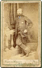
Photograph, B&W, Henry Box 1839 - 1913, c1888
... Baptist Church.. Surviving Children were - Caroline Alma Box... Baptist Church.. Surviving Children were - Caroline Alma Box 1863 ...Henry Box ,who was born in Withyham in 1839 , was the 3rd son of George and Mary Cripps Box and came to Australia in 1856 with the family. Henry paid his own fare so was not ‘bound’ to any employer. Henry helped his brother William establish his market garden on the site of Box Cottage, Jasper Road 1865 and by 1970 was purchasing property in East Brighton (Bentleigh.). He continued to purchase land, which he rent / leased to family members, and at his death owned property in East Boundary Road, Murrumbeena and Elsternwick. Henry married Elizabeth ‘Emma’ Ward in 1868 and they had 9 children but 2 died in infancy. ‘ Emma’ was the daughter of William Ward 1820- 1908 who was born in Norfolk and emigrated with his wife Ann Ostler in 1853. Henry was a member of the Court Pride of St George AOF, and a lay preacher at the Bentleigh Baptist Church.. Surviving Children were - Caroline Alma Box 1863-1943, Mary Anne Box 1865- ?, Lydia Elizabeth Box 1867- 1957, William Henry Box 1869- 1945, Emma Elizabeth Ellen Box 1875 – 1964, Olivia Christina ‘Chrissie’ Box 1878 – 1963, Archibald Ward Box 1882 -? Box Cottage Museum, a reconstruction of an early settler hut, is named after the Box family who resided there 1865 -1913 . William Box who with his wife Elizabeth Avis Box and 13 children lived and farmed on the block of land in Jasper Road, East Brighton ( now McKinnon / Ormond) that was part of the Henry Dendy Special Survey 1841 . Henry Box, a brother of William Box, was born in Withyham, Sussex and came to Australia with his parents George and Mary Box and siblings in 1856. He purchased property and helped the family establish market gardens in East Brighton (Bentleigh). Henry and his wife Elizabeth Emma Ward Box had 9 children, Henry was a lay preacher for the Baptist Church Bentleigh. Inscribed in Album “ The early photos in this album were found by Mr (Laurie) Lewis when he was demolishing the Old Box Cottage. He gave them to Mrs Avis Box Eldridge who in turn gave them to me. They were not identified. I believe they rightly belong in the Cottage. I have attempted to identify them and present them in a way they can be preserved as a historical record of the era.” A B Leigh A black and white photograph of Henry Box 1839 - 1913Bensen & Stevenson Photos / 108 Elizabeth St. Melbourne/ COPIES CAN BE OBTAINED AT ANY TIME -
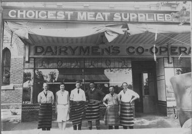 Bacchus Marsh & District Historical Society
Photograph, Dairymen's Co-operative Butchers Shop. Main Street Bacchus Marsh. 1923
... of the brick Baptist Church can be seen. The store frontage continues... of the brick Baptist Church can be seen. The store frontage continues ...Bacchus Marsh Dairymen's Co-operative Association factory began in 1910. The Co-op, as it was known locally, also had a store in Main Street. This butcher's shop was opened in 1923 and was located at 160 Main Street. The Co-op purchased milk from local farmers and trucked the milk direct to a factory in Melbourne. Due to financial difficulties, the Co-op ceased trading in the early 1980s. Records show that this site was in continuous use as a butcher's and allied industries from 1856 to 2011. The original building underwent several changes and additions until it was sold in 1922 to the Dairymen's Co-operative, who erected a new brick building in 1923. This building housed the Hospital Opportunity Shop from 2011 until 2016 when it was taken over by Natural Health and is still in use by this business.Black and white photographic print mounted on grey cardboard with decorative borders. Photo shows staff standing in front of the shop with two store signs. Along the top the verandah a sign reads: CHOICEST MEAT SUPPLIED. The lower sign along the top of the shop frontage reads: DAIRYMEN'S CO-OPERA. This sign is incomplete, indicating that the butcher's shop was part of the Dairymen's Co-operative Association store. At the front of the store six members of the staff stand in a line. There are five men, all wearing the traditional blue and white striped butcher's apron and one woman who is probably the cashier. At the top of the cantilever verandah, two rolls of canvas awning are tied up, ready to be let down on a hot day. On the left of the photo a portion of the brick Baptist Church can be seen. The store frontage continues to the right. The reflection of the store on the opposite side of the street can be seen in the window. The store frontage is finished with tiles along the bottom of the display window and an inset of leaded glass along the top of the window. On the footpath there is a scattering of sawdust, once used traditionally in butcher shops to soak up blood from the meat. The end of a 1920's vehicle has been captured as it passes in front of the store. On the back: On a printed label: OPENING OF BACCHUS MARSH DAIRYMAN'S CO-OPERATIVE BUTCHERS SHOP. 1923 L. to R. Norm Farrow, Sheila Muir, Bill Bence, Norm Mathews, Jim Cash and Ern Coe, (Manager). shops bacchus marsh vic., bacchus marsh dairymen's co-operative association, butcher's shops, main street bacchus marsh vic. -
 City of Moorabbin Historical Society (Operating the Box Cottage Museum)
Photograph, B&W, a son of Henry Box 1839 -1913, c1900
... at the Bentleigh Baptist Church.. Surviving Children were - Caroline... Baptist Church.. Surviving Children were - Caroline Alma Box 1863 ...Henry Box ,who was born in Withyham, Sussex in 1839 , was the 3rd son of George and Mary Cripps Box and came to Australia in 1856 with the family. Henry paid his own fare so was not ‘bound’ to any employer. Henry helped his brother William establish his market garden on the site of Box Cottage, Jasper Road 1865 and by 1970 was purchasing property in East Brighton (Bentleigh.). He continued to purchase land, which he rent / leased to family members, and at his death in 1913 owned property in East Boundary Road, Murrumbeena and Elsternwick. Henry married Elizabeth ‘Emma’ Ward in 1868 and they had 9 children but 2 died in infancy. ‘ Emma’ was the daughter of William Ward 1820- 1908 who was born in Norfolk and emigrated with his wife Ann Ostler in 1853. Henry was a member of the Court Pride of St George AOF, and a lay preacher at the Bentleigh Baptist Church.. Surviving Children were - Caroline Alma Box 1863-1943, Mary Anne Box 1865- ?, Lydia Elizabeth Box 1867- 1957, William Henry Box 1869- 1945, Emma Elizabeth Ellen Box 1875 – 1964, Olivia Christina ‘Chrissie’ Box 1878 – 1963, Archibald Ward Box 1882 -? Box Cottage Museum, a reconstruction of an early settler hut, is named after the Box family who resided there 1865 -1913 . William Box who with his wife Elizabeth Avis Box and 13 children lived and farmed on the block of land in Jasper Road, East Brighton ( now McKinnon / Ormond) that was part of the Henry Dendy Special Survey 1841 . Henry Box, a brother of William Box, was born in Withyham, Sussex and came to Australia with his parents George and Mary Box and siblings in 1856. He purchased property and helped the family establish market gardens in East Brighton (Bentleigh). Henry and his wife Elizabeth Emma Ward Box had 9 children, Henry was a lay preacher for the Baptist Church Bentleigh. Inscribed in Album “ The early photos in this album were found by Mr (Laurie) Lewis when he was demolishing the Old Box Cottage. He gave them to Mrs Avis Box Eldridge who in turn gave them to me. They were not identified. I believe they rightly belong in the Cottage. I have attempted to identify them and present them in a way they can be preserved as a historical record of the era.” A B Leigh A black and white photograph of a boy who could be a son of Henry Box 1839 -1913BENSEN & STEVENSON PHOTOS / 108 Elizabeth Street Melbourne/ COPIES CAN BE OBTAINED AT ANY TIME -
 Brighton Historical Society
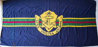
Flag, School flag, circa 1914 - 1956
... Baptist Church in 1956. Following this final sale, the school... it to a Miss Bury, who in turn sold it to the local Baptist Church ...This flag was used by Esperance Girls School, a private school based in Brighton from 1894-1956. Esperance was established in 1894 at 6 Normanby Street by Misses Emsie, Marion, Gussie and Daisy Beaver. The four sisters came from a formerly-prosperous land-owning family that had suffered badly as a result of the depression of the early 1890s. At a time when few occupations were open to gentlewomen, running a school provided the sisters with a respectable means of supporting themselves. Notable teachers at Esperance during the 1890s included elocution mistress Miss Jeannie Taylor, who would later become better known as the author Mrs Aeneas Gunn. In 1924 the school was sold to Miss Marian Taylor and Miss Christina McMillan, who had previously served as joint principals of Alexandra College in Hamilton between 1909 and 1913. Both women had strong family connections to Brighton: Christina was the granddaughter of early pioneer Archibald McMillan and Marian was a relative of long-serving town clerk J. H. Taylor. The new principals relocated the school to a large two-storey house on the corner of Park Street and Esperance Avenue, where it remained until its closure. They operated the school until 1950, when they sold it to a Miss Bury, who in turn sold it to the local Baptist Church in 1956. Following this final sale, the school continued for another four terms before closing.Navy blue flag, both sides featuring a large yellow-gold crest in centre, containing image of an anchor and surrounded by semicircular scroll with the motto "SPES ANCORA ANIMAE". Background features horizontal green stripe across centre, containing smaller red stripe and bordered on each side by yellow stripes.esperance girls school, flag, school flag -
 Ballarat and District Irish Association
Photograph - Colour, Clare Gervasoni, St Patrick's Cathedral Hall, Ballarat, 2007, 20/11/2007
... include St Andrew's Kirk and the former Baptist Church, opposite... include St Andrew's Kirk and the former Baptist Church, opposite ...St Patrick's Cathedral Hall was erected in 1900 to the architectural plans of Clegg, Kell and Miller. The builder was Peter Bodger. The Cathedral Hall is a massive structure in the Gothic manner, with slender proportions and Gothic window detailing. The main hipped roof of the hall is intersected on both sides by four gables, and the front ridge is intersected by two further gables to form the street elevation. Internally the hall resembles many town halls except for the two tiers of Gothic windows and the manner in which the ceiling curves downward towards the walls. Pointed Gothic windows on the upper level intersect the curved ceiling in a simple groined junction. The plaster ceiling is coffered by intersecting beams, while a central skylight floods the hall with natural light. Other features of note are the ridging on the front gables, and the iron bell tower framed in steel angles and braced with criss-crossed rods, complete with a huge wheel and a great bell. St Patrick's Hall demonstrates a notable application of decorative schemes, particularly its highly decorated ceiling which has few parallels amongst other church halls in Victoria. The hall is in an important location as part of St Patrick's complex, as well as part of the group of churches which include St Andrew's Kirk and the former Baptist Church, opposite in Dawson Street. (http://stpatscathedral.weebly.com/cathedral-hall--presbytery.html, accessed 13 November 2013.A series of colour digital photographs showing a large red brick hall associated with St Patrick's Cathedral, Ballarat. The bell tower is situated to the right of the hall.ballarat irish, st patrick's cathedral hall, cathedral hall ballarat, bell, bell tower -
 Federation University Historical Collection
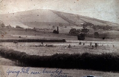
Photograph (Black & White), Spring Hill Near Creswick
... Dawson Street Baptist Church. Here he married a widow with 2 sons... Dawson Street Baptist Church. Here he married a widow with 2 sons ...Both images are associated with Ellie Campbell. James and Bridget Martin were early settlers at Spring Hill. All their children attended the Ballarat School of Mines..1) A black and white image of Spring Hill near Creswick, glued into a thick card with a gold gilt edge. .2) Martin family house at Subiaco Hill, Western Australia. Brick house built by Corby Statford Cambell, Elly Campbell's father. .1) Written in blue pen on front of photograph 'Spring Hill near Creswick - Victoria' Taped onto back 'Farmland allotted to James George Martin in c1849. He took his bride, Bridget Hyde (19 years old) by bullock dray from St James Church, Elizabeth Street, Melbourne to this new allotment - 10 children born there - William, Robert, Samuel, Elizabeth, Ellen, Emily, Mary (died 2 months old mother also died). J.G.M. moved to Ballarat - attended Dawson Street Baptist Church. Here he married a widow with 2 sons, Mrs ____. Her 2 sons were born, George and Charles (was in USA) . Children all attended School of Mines, Ballarat .2) On yellow sticky label with photo - "Family home Subiace Rd Subiac WA. Builtby Statford Campbell, Elly's fayher. Now Coppin St.ballarat school of mines, william martin, james martin, bridget martin, bridget hyde, samuel martin, elizabeth martin, ellen martin, mary martin, george martin, charles martin -
 City of Moorabbin Historical Society (Operating the Box Cottage Museum)
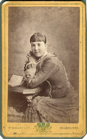
Photograph, B&W, possibly Elizabeth Emma Ward wife of Henry Box, 1880
... at the Bentleigh Baptist Church.. Surviving Children were - Caroline... at the Bentleigh Baptist Church.. Surviving Children were - Caroline Alma ...Henry Box ,who was born in Withyham in 1839 , was the 3rd son of George and Mary Cripps Box and came to Australia in 1856 with the family. Henry paid his own fare so was not ‘bound’ to any employer. Henry helped his brother William establish his market garden on the site of Box Cottage, Jasper Road 1865 and by 1970 was purchasing property in East Brighton (Bentleigh.). He continued to purchase land, which he rent / leased to family members, and at his death owned property in East Boundary Road, Murrumbeena and Elsternwick. Henry married Elizabeth ‘Emma’ Ward in 1868 and they had 9 children but 2 died in infancy. ‘ Emma’ was the daughter of William Ward 1820- 1908 who was born in Norfolk and emigrated with his wife Ann Ostler in 1853. William Ward JP was a prominent figure in East Brighton . William was elected to the Moorabbin Road Board in 1863, JP at Cheltenham Court, and Shire President 1875-82. He was appointed Post Master at East Brighton in 1865 and held the position until his death in 1908 Henry was a member of the Court Pride of St George AOF, and a lay preacher at the Bentleigh Baptist Church.. Surviving Children were - Caroline Alma Box 1863-1943, Mary Anne Box 1865- ?, Lydia Elizabeth Box 1867- 1957, William Henry Box 1869- 1945, Emma Elizabeth Ellen Box 1875 – 1964, Olivia Christina ‘Chrissie’ Box 1878 – 1963, Archibald Ward Box 1882 -? Box Cottage Museum, a reconstruction of an early settler hut, is named after the Box family who resided there 1865 -1913 . William Box who with his wife Elizabeth Avis Box and 13 children lived and farmed on the block of land in Jasper Road, East Brighton ( now McKinnon / Ormond) that was part of the Henry Dendy Special Survey 1841 . Henry Box, a brother of William Box, was born in Withyham, Sussex and came to Australia with his parents George and Mary Box and siblings in 1856. He purchased property and helped the family establish market gardens in East Brighton (Bentleigh). Henry and his wife Elizabeth Emma Ward Box had 9 children, Henry was a lay preacher for the Baptist Church Bentleigh. Inscribed in Album “ The early photos in this album were found by Mr (Laurie) Lewis when he was demolishing the Old Box Cottage. He gave them to Mrs Avis Box Eldridge who in turn gave them to me. They were not identified. I believe they rightly belong in the Cottage. I have attempted to identify them and present them in a way they can be preserved as a historical record of the era.” A B Leigh A black and white photograph of a young woman who may be Elizabeth Emma Ward 1863 - 1921,the wife of Henry Box.1839-1913Stewart & Co ' Coat of Arms" Melbourne -
 Federation University Historical Collection
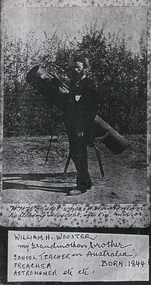
Photograph, William H. Wooster at the Ballarat Observatory, Mount Pleasant
... of England, Mt Pleasant Wes. Chapl., Baptist Church; & many other...., Baptist Church; & many other places. Preached i the Neil St. Wes ...An image of W.H. Wooster with telescope, and a page copy of his handwritten notes outlining his achievements.7707.2 "Notes Grandpa has lectured scores of times in the Sch. of Mines, sometimes for one of the Professors who was ill. Also Lectured in the City Fire Brigade, Ballarat E Fire Brigade, Barkley St Wesn chap., Lydiard St. Wes. Chapl, St Peter's Church of England, Mt Pleasant Wes. Chapl., Baptist Church; & many other places. Preached i the Neil St. Wes. Chapels at Brown Hill, the Gong, Ltl Bendigo, Golden Point, Macarthur St., Mnt Pleasant, the Bible Christian Chppl., and many others. Too photos of most of the places shown in these "Ballarat Views", and many others. And laid the Foundation of the fine Municipal Observatory, in a long series of "Astronomical" and other "Scientific Notes", published in the Ballarat Courier and Ballarat Star, & occasionally in another Newspaper, which roused much public interest in Astronomy. The present official astronomer, Mr John Brittain, is my pupil in Astronomy and Microscopy, and calls me his Father in Science. W.H. Wooster."w.h. wooster, ballarat observatory, microscope, microscopy, churched, preaching, lay preacher, ballarat school of mines, ballarat field naturalists club, observatory, telescope -
 Flagstaff Hill Maritime Museum and Village
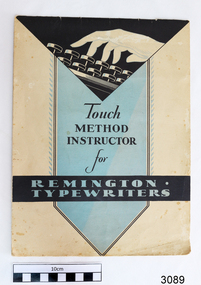
Book, Touch Method Instructor for Remington Typewriters, c. 1931
... warrnambool baptist church... preaching in the Baptist Church, and the typewriter gained a lot... preaching in the Baptist Church, and the typewriter gained a lot ...The instruction book was donated together with a typewriter and manual by David Sack, previous owner of Sack's Jewellers, Liebig St in Warrnambool. The typewriter and books were owned by William Sack, owner of the business Sacks Jewellers at 115 Liebig Street, Warrnambool. He commenced trading in the early 1900’s; and used this typewriter in the business from its purchase date, around 1931, through until about 1996. William and his wife June had three children, Eric, Audrey and David. The children were owners/partners of Sack’s Jewellers after William’s passing in 1976. Eric and David were ‘owners of the business’, with Audrey carrying out much of the clerical work. Eric died in about 1984 and David sold the practise in 1996. During the 65 years of business the typewriter was used for all the normal applications of a jeweller’s; preparing invoices, guarantees, taxation records. But in addition the four members of the Sack family were very involved in Church activities, particularly in lay administration and lay preaching in the Baptist Church, and the typewriter gained a lot of after-hours use. The family actively supported overseas Missions in India, SE Asia, and Africa. After the sale of the business in 1996, Audrey took the typewriter home for her community activities (David got a computer). In the 1980’s David volunteered as the Clock Repairer at Flagstaff Hill for the historical instruments. In the early days this took some long hours to get the clocks working, but in recent years he has just been ‘on call’ if needed. He is an alert 85 year old and just in the last 12 months has given up a busy schedule of Sunday Lay Preaching around the district. (2015) The typewriter and instruction books are of local significance, being previously owned and used in a local business for about 100 years.Book, Touch Method Instructor for Remington Typewriters. Published by Remington Typewriter Company, printed in U.S.A. Copyright 1931. Soft cover, cream with black and blue panels, drawing of a hand with fingers above typewriter keys. Lesson book for teaching touch typing.flagstaff hill, warrnambool, shipwrecked coast, flagstaff hill maritime museum, maritime museum, shipwreck coast, flagstaff hill maritime village, great ocean road, typing instructor, typing lesson book, sack’s jewellers warrnambool, remington typewriter company, william sack, david sack, warrnambool baptist church, warrnambool history -
 Eltham District Historical Society Inc
Photograph, Stokes Place, Eltham, July 1977, July 1977
... on Nyora now the Baptist Church visible in middle view. Frank... on Nyora now the Baptist Church visible in middle view. Frank ...Viewed from near the end of Stokes Place where the linear reserve now runs between 8 and 9 Stokes Place looking slightly east of south towards Nyora Road. The new Christian Church on Nyora now the Baptist Church visible in middle view. Frank Stokes first traveled to the district by train in 1944 to find land with the intention to establish an orchard. By chance he met Arthur Bird of Bird Orchard (bounded by Pitt Street, Eucalyptus Road and Wattle Grove) and they got talking over their common interest. Arthur put Frank up for the night and pointed out the land, part of Crown Allotment 15, Section 5, Parish of Nillumbik (CA15) somewhat diagonally opposite Bird Orchard. Frank bought the land and for the next two years would travel by train from Melbourne to Eltham every weekend establishing Stokes Orchard and building a home for his family, which they eventually moved into in 1946. In the mid 1970s the Shire of Eltham divided the orchard up into numerous rate-able parcel lots, which became affordable for Frank. As a consequence Stokes Orchard was turned into a housing development by Macquarie Builders and marketed as the Stokes Orchard Estate in two stages; Stage 1 encompassing Scarlet Ash Court, Ironbark Close and Peppermint Grove bounded by Nyora and Eucalyptus roads c.1976 and Stage 2 encompassing Stokes Place, Orchard Way, The Crest and The Lookout bound by Nyora and Diosma roads c.1979. The development of Orchard Way, The Crest and The Lookout did not proceed as planned due to the lack of the sewer along Diosma Road and so many of the proposed lots were incorporated into five-acre parcels instead.Housing development in Eltham as an extension to the Woodridge EstateDigital file only - Digitised by EDHS from a scrapbook (containing commercially printed photos of digital scans) on loan from Beryl Bradbury (nee Stokes), daughter of Frank Stokes.1977-07, beryl bradbury (nee stokes) collection, eltham, eltham christian church, stokes orchard estate, stokes place -
 Flagstaff Hill Maritime Museum and Village
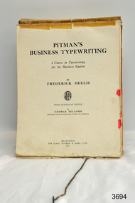
Book - Textbook, Pitman's Business Typing, 1937
... members of the Sack family were very involved in Church activities... members of the Sack family were very involved in Church activities ...This Pitman’s Business Typing textbook was owned by Audrey Sack and was donated by David Sack at the same time as a typewriter in its case plus accessories (refer to RN 3087). Audrey was the daughter of William Sack, owner of the business Sacks Jewellers at 115 Liebig Street, Warrnambool. William commenced trading in the early 1900’s; and the typewriter was used by Audrey in the business from the late 1930’s through to about 1996 when the business was sold. William and his wife June had three children, Eric, Audrey and David. The children were owners/partners of Sack’s Jewellers after William’s passing in 1976. Eric and David were ‘owners of the business’, with Audrey carrying out much of the clerical work. Eric died in about 1984 and David sold the practise in 1996. During the 65 years of business the typewriter was used for all the normal applications of a jeweller’s; preparing invoices, guarantees, taxation records. But in addition the four members of the Sack family were very involved in Church activities, particularly in lay administration and lay preaching in the Baptist Church, and the typewriter gained a lot of after-hours use. The family actively supported overseas Missions in India, SE Asia, and Africa. After the sale of the business in 1996, Audrey took the typewriter home for her community activities (David got a computer). In the 1980’s David volunteered as the Clock Repairer at Flagstaff Hill for the historical instruments. In the early days this took some long hours to get the clocks working, but in recent years he has just been ‘on call’ if needed. He is an alert 85 year old and just in the last 12 months has given up a busy schedule of Sunday Lay Preaching around the district. (2015) The textbook is associated with the typewriter, which is of local significance, being previously owned and used in a local business for about 100 years.Textbook, "Pitman's Business Typing". Brown paper covered, hard cover, published in 1937. Book has attached cord to enable it to stand during use. Book belonged to Audrey Sack.Handwriten name "Audrey Sack, … Warrnambool …WHS" (Warrnambool High School) 18/8/15"flagstaff hill, warrnambool, shipwrecked coast, flagstaff hill maritime museum, maritime museum, shipwreck coast, flagstaff hill maritime village, great ocean road, typewriter, touch typing, office communications, sack’s jewellers warrnambool, william sack, david sack, audrey sack, typing textbook -
 Flagstaff Hill Maritime Museum and Village
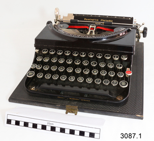
Machine - Typewriter, 1930's
... warrnambool baptist church... preaching in the Baptist Church, and the typewriter gained a lot... preaching in the Baptist Church, and the typewriter gained a lot ...This "Remington Portable Model 5, Remington Business Service" typewriter is in very good working order and was donated in its case complete with its Operating Instructions and a Touch Method typing instruction book. The typewriter was owned by William Sack, owner of the business Sacks Jewellers at 115 Liebig Street, Warrnambool. He commenced trading in the early 1900’s; and used this typewriter in the business from its purchase date, around 1931, through until about 1996. William and his wife June had three children, Eric, Audrey and David. The children were owners/partners of Sack’s Jewellers after William’s passing in 1976. Eric and David were ‘owners of the business’, with Audrey carrying out much of the clerical work. Eric died in about 1984 and David sold the practise in 1996. During the 65 years of business the typewriter was used for all the normal applications of a jeweller’s; preparing invoices, guarantees, taxation records. But in addition the four members of the Sack family were very involved in Church activities, particularly in lay administration and lay preaching in the Baptist Church, and the typewriter gained a lot of after-hours use. The family actively supported overseas Missions in India, SE Asia, and Africa. After the sale of the business in 1996, Audrey took the typewriter home for her community activities (David got a computer). In the 1980’s David volunteered as the Clock Repairer at Flagstaff Hill for the historical instruments. In the early days this took some long hours to get the clocks working, but in recent years he has just been ‘on call’ if needed. He is an alert 85 year old and just in the last 12 months has given up a busy schedule of Sunday Lay Preaching around the district. (2015)The typewriter is of local significance, being previously owned and used by Sacks Jewellers, a local business that had been in operation for about 100 years.Typewriter, Remington, "Remington Portable Model 5, Remington Business Service". Typewriter is in black, textured hard case with lock and key. Case has leather carry handle. Company has USA, copyright 1931.Includes Operating Instructions for the Remington Portable Models 5 and 5T. Remington Typewriter Company. "Remington Portable Model 5, Remington Business Service". flagstaff hill, warrnambool, shipwrecked coast, flagstaff hill maritime museum, maritime museum, shipwreck coast, flagstaff hill maritime village, great ocean road, typewriter, remington business services, office equipment, business equipment, office communication, sack’s jewellers warrnambool, warrnambool business, remington typewriter company, touch typing, william sack, david sack, warrnambool baptist church -
 Flagstaff Hill Maritime Museum and Village
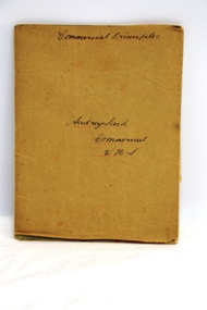
Book - Student Exercise Book, Audrey Sack, student, Commercial Principles, 1938-1939
... in the Baptist Church, and the typewriter gained a lot of after-hours use... in the Baptist Church, and the typewriter gained a lot of after-hours use ...This exercise book was owned by Audrey Sack and was donated by David Sack at the same time as a typewriter in its case plus accessories (refer to RN 3087). It has hand written notes of Commercial Principles class lessons from Warrnambool High School, written by Audrey Sack including pages dated 1938 and 1939. Audrey was the daughter of William Sack, owner of the business Sacks Jewellers at 115 Liebig Street, Warrnambool. William commenced trading in the early 1900’s; and the typewriter was used by Audrey in the business from the late 1930’s through to about 1996 when the business was sold. William and his wife June had three children, Eric, Audrey and David. The children were owners/partners of Sack’s Jewellers after William’s passing in 1976. Eric and David were ‘owners of the business’, with Audrey carrying out much of the clerical work. Eric died in about 1984 and David sold the practise in 1996. During the 65 years of business the typewriter was used for all the normal applications of a jeweller’s; preparing invoices, guarantees, taxation records. But in addition the four members of the Sack family were very involved in Church activities, particularly in lay administration and lay preaching in the Baptist Church, and the typewriter gained a lot of after-hours use. The family actively supported overseas Missions in India, SE Asia, and Africa. After the sale of the business in 1996, Audrey took the typewriter home for her community activities (David got a computer). In the 1980’s David volunteered as the Clock Repairer at Flagstaff Hill for the historical instruments. In the early days this took some long hours to get the clocks working, but in recent years he has just been ‘on call’ if needed. He is an alert 85 year old and just in the last 12 months has given up a busy schedule of Sunday Lay Preaching around the district. (2015)The exercise book is associated with a typewriter and text book, which is of local significance, being previously owned and used in a local business established for about 100 years.Book, student's exercise book with brown paper cover over soft cover. White pages have printed blue lines. Notes written in script with nib pen. Correction marks are on some pages. The book has entries from front to just past the centre pages, the turned upside down and written from back to almost centre pages. It belong to Autrey Sack, who was a Commercial Practices student at Warrnambool High School. Handwritten ink pen inscriptions are on the front cover and within the book. Notes are dated as 1938 and 1939."Commercial Principles" "Audrey Sack /. Commercial / W.H.S."flagstaff hill, warrnambool, flagstaff hill maritime museum, maritime museum, shipwreck coast, flagstaff hill maritime village, great ocean road, commercial principles, warrnambool high school, sack’s jewellers warrnambool, william sack, david sack, audrey sack, sack’s jewellers, exercise book, student notes, business education -
 Federation University Historical Collection
Photograph - Photograph Album, Photographs of Ballarat Buildings by Geoff Biddington, 1967, 1967
... former ballarat baptist church, dawson street... Presbyterian Church? .8) Former Ballarat Baptist Church, Dawson Street... church? former ballarat baptist church, dawson street church ...At one time Her Majesty's Theatre was known as the Memorial Theatre. When these photos were taken Geoffrey Biddington was highly involved with the Ballarat Branch of the National Trust. Lenaghan of Tourello "Master Dan Lenaghan, eldest son of Mr. and Mrs. R. Lenaghan, of Tourello, has been successful in obtaining a Government scholarship, tenable for four years at St. Patrick's College, Ballarat.(Melbourne Advocate, 02 March 1939) Black folders of Ballarat photographs as follows: .1) Ballarat City Council Logo on Ballarat Botanical Garden Gates .2) Ballarat Railway Station .3) Ballarat Town Hall .4) Ballarat Fire Station, Ballarat East .5) Interior of Ballarat Railway Stations .6) Ballaarat Municipal Libraries Barkly Street Branch, formerly Ballarat East Library .7) Entrance to Ballarat Presbyterian Church? .8) Former Ballarat Baptist Church, Dawson Street .9) Church with small steeple, erected AD 1860 .10) Brick Church with steeple .12) Gates of the former Ballarat Gaol .13) Gates of the former Ballarat Gaol .15) Craig's Hotel, Nominee Brian D. Foley .16) ? .17) Interior of Her Majesty's Theatre, Ballarat .18) Bailey's Mansion, later used as the St John of God Convent .19) Lal Lal Blast Furnace .20) Gates of St Patricks Cathedral Ballarat, looking towards the Cathedral Hall .21) .20) Gates of St Patricks Cathedra, Sturt Street, Ballarat .22) ? .23) Lenaghan's Tourello .24) Ballarat Terrace, c1967 .25) Entrance to Ballarat Terrace, c1967 .26) ? .27) Entrance gate to Novar, Webster Street, Ballarat .28) Interior of Ballarat Railway Station, c1967 .30) Pratt's Warehouse, Camp Street, Ballarat, c1967 .31) Entrance gate to Novar, Webster Street, Ballarat .32) Cast Iron Gate .33) Cast Iron Gate .34) Cast Iron Gate .35) Ballarat New Cemetery Gates .36) Cast Iron Post Cap .37) Cast Iron lamp .38) Cast Iron lamp .39) Ballarat Botanical Gardens Statuary Pavilion .40) 'Flight of Pompeii' statue in the Ballarat Botanical Gardens Statuary Pavilion ballarat city council logo on ballarat botanical garden gates, ballarat botanical garden gates, ballarat railway station, ballarat town hall, ballarat fire station, ballarat east, interior of ballarat railway stations, ballaarat municipal libraries barkly street branch, formerly ballarat east library, entrance to ballarat presbyterian church?, former ballarat baptist church, dawson street, church with small steeple, erected ad 1860, brick church with steeple, gates of the former ballarat gaol, craig's hotel, nominee brian d. foley, brian d. foley, interior of her majesty's theatre, ballarat, bailey's mansion, later used as the st john of god convent, lal lal blast furnace, gates of st patricks cathedral ballarat, looking towards the cathedral hall, gates of st patricks cathedral, lenaghan's tourello, ballarat terrace,, entrance to ballarat terrace, entrance gate to novar, webster street, ballarat, interior of ballarat railway station, c1967, pratt's warehouse, camp street, ballarat, c1967, cast iron gate, ballarat new cemetery gates, cast iron post cap, cast iron lamp, ballarat botanical gardens statuary pavilion, 'flight of pompeii' statue, architectural features -
 Eltham District Historical Society Inc
Photograph - Digital Photograph, Alan King, Diamond Creek, Barak Bushlands, Eltham, 2008
... members, Eltham Lions Club and the Eltham Baptist Church... members, Eltham Lions Club and the Eltham Baptist Church ...A habitat corridor and it strengthens the community. Published: Nillumbik Now and Then / Marguerite Marshall 2008; photographs Alan King with Marguerite Marshall.; p185 Barak Bushlands lie west of the Diamond Creek on the corner of Falkiner Street and busy, noisy Main Road. They form part of an important habitat corridor linking the Yarra River to the Kinglake National Park.1 Manna Gums, tawny frogmouths and platypuses are some of the indigenous plants and animals that have made their home there. The bushlands are the result of more than nine years of hard work by the local community with the Nillumbik Council, to transform a degraded flood plain into this refuge of natural beauty. In 1997, shortly after moving into the new Riverside Estate on Falkiner Street, Eltham, several residents noticed the sorry state of the Diamond Creek and surrounding area. Part of it was used as a cow paddock and although small patches of vegetation survived, the area was infested with weeds, rabbits, rubbish and drainage from the housing estate. At various times the 4.4 hectares had been used as a market garden and for shire stock piles. The residents began to restore the area by revegetating land along the Diamond Creek. In 1998 they established the Friends of the Diamond Creek Falkiner Street Reserve2 and 35 families joined from the 90-house Estate. Carolyn Mellor, as the Friends’ Land Manager, undertook a four-year horticulture course to guide this massive project for a volunteer organisation. Since 1999, she has been the Friends’ President. In 1999 the Friends urged the Nillumbik Council to undertake a feasibility study into establishing a wetland system and urban forest. Work began in 2002 with Nillumbik Council funding the project, supplemented by government grants. The Friends also received grants from Melbourne Water and Parks Victoria. Aided by the Friends and other community members, the Council created the Barak Bushlands consisting of a forest, a wetland, a bridge, a path and open space. The beautiful wetland treats most of the estate’s stormwater runoff. Storm water is filtered through plants in the wetland ponds then is released slowly into the billabong, before flowing into the Diamond Creek. The wetland also helps to minimise flooding and the improved water quality provides a flora and fauna habitat. The Friends and other volunteers planted more than 27,000 plants, more than one third of which they grew from seeds they collected at Lower Eltham and Wingrove Parks. Eltham High School students planted thousands of these through a Year Eight program introduced for this purpose. Other groups who assisted were: Green Corps, local Scouts and Guides – 2nd Montmorency, 1st Diamond Creek and 1st Eltham Cub Packs, Eltham College students, Eltham East Primary School, Landcare members, Eltham Lions Club and the Eltham Baptist Church. To maintain enthusiasm for the mammoth task, the Friends and other volunteers ‘adopted’ trees to water and wrote their names on the stakes. In 2004, to recognise the area’s original occupiers, the reserve was named Barak Bushlands. William Barak, who lived from 1824 to 1903, was the last chief of the Yarra Yarra tribe of the Wurundjeri-willam people. Traces of these original inhabitants remain in scar trees (bark sections removed to make a shield or canoe). That same year the Friends’ group was a finalist in the prestigious Federal Government, Banksia Environmental Awards. The Friends have also participated in Clean Up Australia, removing tonnes of rubbish and regularly testing the billabong, wetland and creek, for pollutants. For years the Friends, together with the Australian Platypus Conservancy, have tagged, measured and checked the health of platypuses from the Diamond and Mullum Mullum Creeks. With Latrobe University the Friends have conducted night walks to view owls, possums, bats and sugar gliders. Challenges for the council and the Friends continue with a large rabbit population, some vandalism, weed eradication and maintenance. However, thanks to this community effort, locals can now escape confined urban living on small blocks of land and enjoy the beauty of indigenous plants and animals. Working together has also strengthened the local community,This collection of almost 130 photos about places and people within the Shire of Nillumbik, an urban and rural municipality in Melbourne's north, contributes to an understanding of the history of the Shire. Published in 2008 immediately prior to the Black Saturday bushfires of February 7, 2009, it documents sites that were impacted, and in some cases destroyed by the fires. It includes photographs taken especially for the publication, creating a unique time capsule representing the Shire in the early 21st century. It remains the most recent comprehenesive publication devoted to the Shire's history connecting local residents to the past. nillumbik now and then (marshall-king) collection, barak bushlands, diamond creek (creek), eltham -
 Eltham District Historical Society Inc
Photograph - Digital Photograph, Marguerite Marshall, Eltham Retirement Centre (Judge Book Memorial Village), Diamond Street, Eltham, 23 October 2006
... Baptist Church. Book was also President of the Baptist Union... Baptist Church. Book was also President of the Baptist Union ...Thousands of elderly people at this centre have contributed much. Published: Nillumbik Now and Then / Marguerite Marshall 2008; photographs Alan King with Marguerite Marshall.; p161 Thousands of elderly people, who have contributed much to Nillumbik and beyond, have made their home in the treed Eltham Retirement Centre. The centre, which opened in 1956, has housed the disadvantaged in particular, through good times and hard, including floods, fire and even burglaries. As part of the Melbourne Citymission, a non-denominational Christian organisation that cares for people living with disadvantage, the centre was built to celebrate 100 years of the Melbourne Citymission’s work since 1854. Standing on a former poultry farm called Willandra (Still Waters), the centre includes independent units, hostel, nursing home accommodation and a Day Therapy Centre, which is available for non-residents as well. Despite being metres from the busy Main Road and railway station, the centre provides a quiet oasis on 6.8 hectares bordered by the Diamond Creek to the west, and the railway line to the east. The centre was originally named Judge Book Memorial Village after Judge Clifford Book, Deacon of the Collins Street Baptist Church. Book was also President of the Baptist Union of Victoria and Grand Master of the Masonic Lodge. He was so respected that, at his death, several Pentridge prisoners asked to attend his funeral. In 1993 the centre’s name was changed to clarify that it was part of the Melbourne Citymission. However Judge Book’s name continues in the Judge Book Memorial Garden, opened in 2006. The Diamond Creek has flooded the centre several times, however rarely causing serious damage. Volunteer Alan Field recalls a flood in 1974 when the resident manager Reverend Norman Pearce and his wife, were rescued by boat from their home with their budgerigar. On February 3, 2005, when the creek almost flooded Metzner Hall, 35 ambulances evacuated residents to nearby nursing homes, hostels and local homes. Residents were also evacuated during the 1965 bush fire, but fortunately a change of wind direction saved the centre. Residents have also endured several burglaries. Despite much rebuilding and modernisation over the years, traces of the original farmhouse remain in the administration areas. In 1991 the Willandra Hostel was built and in 2001 the Eltham Lodge Nursing Home with each room having a garden view. Several buildings are named after people who have given special service to the centre including the Norman Pearce Day Hospital after general manager and pastor Rev Pearce. Metzner Hall was named after the Metzner family who had been active in the auxiliary since it began and had donated generously to the Recreation Hall fund.3 A bridge was named after Sister Lila Murray who had worked at the village for 42 years in various capacities including as relieving manager. Field remembers Sister Murray as ‘the Mother Teresa and soul of what the village aspired to, with love and care’. Since 1957 the Eltham Auxiliary, later called the Residents’ Association, has worked to improve the residents’ quality of life by volunteering and raising funds. An outstanding volunteer, Field, who was drawn to the centre in 1971 with his wife Chris, has held positions on the early Eltham boards, auxiliaries and Residents’ Association. Much of his work has been supporting people with no family and those of limited means. He says he and his wife look at their work as having shared ‘our lives with amazing people’. The wealth of experience and wisdom in the Retirement Village has benefited many people, including local school children. Residents have acted as proxy grand-parents at local schools, by assisting small learning groups or telling their life stories. Conversely, students from local schools have visited to perform, or to assist in programs like craft activities. Resident Val Bell, whose mother Rose Bullock lived at the centre before her, sums up the centre’s most important attribute for her: ‘The Christian care. They could not be more caring’.This collection of almost 130 photos about places and people within the Shire of Nillumbik, an urban and rural municipality in Melbourne's north, contributes to an understanding of the history of the Shire. Published in 2008 immediately prior to the Black Saturday bushfires of February 7, 2009, it documents sites that were impacted, and in some cases destroyed by the fires. It includes photographs taken especially for the publication, creating a unique time capsule representing the Shire in the early 21st century. It remains the most recent comprehenesive publication devoted to the Shire's history connecting local residents to the past. nillumbik now and then (marshall-king) collection, diamond street, eltham, eltham retirement centre, eltham retirement village, judge book memorial village -
 Ringwood and District Historical Society
Document, State School 4688 Heathmont, c 1969
... Baptist Church property thus providing much needed extra... Baptist Church property thus providing much needed extra ...S.S, No 4688, Francis Street, Heathmont, 3135 History Two A4 pages of notes on the beginnings of the Heathmont S.S The text is:- STATE SCHOOL No 4698 Frances Street Heathmont, 3135 HISTORY School classes at Heathmont commenced in the original Methodist Church building in Canterbury Road in 1952 with Mr A.J. McKinlay as Head Teacher in charge of a school of 80 pupils. Shortly afterwards both a Parents and Citizens Association and the first School Committee were formed. Mr J.B. Harper was appointed as president of the Association and Mr H. Walker was elected as chairmen of the Committee, while Mr T. Jago acted as secretary to both bodies. Later in that same year the district Inspector, Mr H. Fleigner since retired and still a Heathmont resident, woe instrumental in obtaining a site for the establishment of the present Heathmont School at the corner of Frances Street and Balfour Avenue. The land was purchased from Mr. Handasyde, an orchardist of Wantirna South. In March 1963 a Bristol prefabricated aluminium building comprising four classrooms and an office was occupied. On April 21st, 1953 the school was opened officially by the Minister for Education, the Hon. A.E. Shepherd MLA. By December of that year the attendance had increased to 191 pupils, Mr N. Gillham was Head Teacher at the time. In February 1955 Mr. K. Gerraty succeeded Mr Gillham and by 1957 attendance had risen to 326 pupils necessitating the provision of additional light timber construction classrooms. Meanwhile the subdivision of large areas of local orchard land into housing estates with its resulting rapidly increasing population presented a persistent school accommodation problem that was met temporarily by the hiring of district church halls to accommodate a steadily rising attendance. Fortunately the tradition of voluntarily contributing to school funds and voluntarily providing labour initiated by the original parent bodies in 1952 was maintained. Then Mr V. Milligan commenced as Head Teacher in 1959, much of the steeply contoured playground area had been terraced, a football oval formed and the basketball court and assembly areas were sealed. These improvements were finally completed largely due to the enthusiasm, vigor and work effected by the School Committee under the chairmanship of Ringwood Councillor Mr JM McRae, as is borne out by the following report by Mr R.J. Chapman, District Inspector in 1961. "The local support by parents given to the Head Teacher and his staff is exceptional and I express my appreciation of their outstanding service." Mr Milligan's contribution to progress, however, lay equally in the internal educational development, particularly with regard to the teaching of reading. A course in the mechanics of speed reading, involving the use of the tachistoscope reading rate controllers and programmed comprehension sets was introduced and a start was made in the building up of a library of literature and reference books. As a result the Education Department appointed a Teacher-librarian to ensure continuity and further progress with this Reading scheme. A feature of Heathmont School is the splendid modern Art/Craft room opened while Mr L. Sebire was head teacher in 1966. This building and courtyard, linked to the original building by a covered way was designed by Mr Salvatore who acted as honorary architect, and was completed by Mr John F. Swan at a cost of �10,000 of which 52% was provided by a School Committee Co-operative loan and 42% by Departmental special grant. Materials used were white sandstone brick and oregon pine. The building bears the name of Councillor J.M. McRae Art Centre as a tribute to the man who did so much to enable its construction. An Art/Craft specialist teacher is provided by the Education Department. As attendance continued to increase to 520 children in 1969, additional accommodation became an urgent necessity. Following negotiations conducted by Mr A. Lethbridge School Committee President, Mr JJ Egan, former Principal and the present Principal, Mr A.S. Don the Education Department Assisted by a second Committee Co-operative loan, purchased the adjacent Baptist Church property thus providing much needed extra accommodation and playground area The newly acquired building is at present in use as two temporary classrooms, but will subsequent be used as a utility rope. A smaller room has been converted to a canteen operated daily by the Parents and Citizens Association, thus providing both a service to the pupils and a source of income. +Additional Keywords: McKinlay, Mr.A G Harper, Mr J.B Walker,Mr.H Fleigner, Mr.H Handasyde, Mr. G Shepherd, Hon. A.E. MLA Gillham, Mr.K Garraty, Mr.K Milligan, Mr.V McRae, Mr. J.M. Chapman,Mr.R.J. Sebire,Mr.L Salvatore,Mr. Swann,Mr.John F. Lethbridge, mr.A Egan,Mr.J.J. Don,Mr.A.S. -
 Melton City Libraries
Photograph, Denominational Church and School, Unknown
... Presbyterian Church Melton Background: A Combined... Presbyterian Church Melton Background: A Combined Denominational ...Presbyterian Church Melton Background: A Combined Denominational Church and School was established in Melton by Protestants from the Presbyterian, Episcopalian, Wesleyan and Baptists denominations. A wooden church was built on the flat area east of the Toolam Toolern Creek. A photo of this church shows the buildings with small houses nearby. In the background the bluestone Presbyterian Church built in 1867 can be seen to the north on Yuille and Sherwin street. The flat area beside the road to Ballarat was subject to flooding and the site was eventually abandoned for a settlement. By the latter part of the 1860s the Church of England and Wesleyan bluestone churches were also being erected in the centre of the township of Melton. The commercial centre developed in High Street from Smith to Palmerston Street. Township of Melton Crown Grants Issued Under Common Law refers to the site of the Combined Denominational Church and School on the east side of Sherwin Street on the corner of Pyke Street. Section 4 Allotments 1 and 10 situated on the corner of Pyke, Bryan and Sherwin Street. The early map has the name of Thomas Cridge on this site. The area known Common (flat) remained open level ground with some cottages and buildings and a milk cooler in the 1930s, Granny Watts house “Lynch Cottage was moved in 1964. Sherwin Street was used until the 1960s with the open area being the used for playing golf. Alterations to the flat occurred when the golf course added to the height and removed the Sherwin Street access. The greens were developed and the height of ground altered the vista across Common. The first Presbyterian Minister in the district was the Reverend Alexander McNicol an advanced student and an experienced missionary from Glasgow, arriving in Melbourne in 1850. He was ordained on the 8th of June and was called to the Bacchus Marsh and Mount Macedon district. On the 1st of May 1851 he was called to Geelong and returned to Bacchus Marsh on February 1856 remaining until July 1859. Group of people in front of the church and school.churches, local identities, education