Showing 429 items matching "department of public works"
-
 Federation University Historical Collection
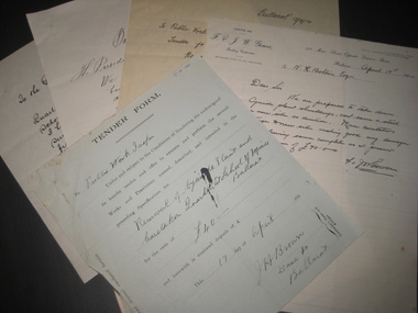
Document, A. Delaland et al, Ballarat School of Mines Cyanide Plant and Caretaker's Cottage, 04/1914
... public works department... gower jw gower william dillon g ludbrook a delaland public works ...The 5 tender documents relate to the removal of Ballarat School of Mines building from along Albert Street Ballarat in preparation for the construction of a new Engineering workshop.Five pages relating to the removal to the Ballarat School of Mines Cyanide Plant and Caretaker's Quarters. (.1) Blue tender form to the Public Works Inspector from J.H. Brown of Dana Street Ballarat relating to the removal to the Ballarat School of Mines Cyanide Plant and Caretaker's Quarters fro 40 pounds (.2) Letter on white ruled paper with F.& J.W. Gower letterhead relating to a tender to remove the Ballarat School of Mines Cyanide Plant and Caretaker's Quarters for 70 pounds (.3) Letter on white paper from William Dillon of 38 Humffray Street Ballarat East converning the relating to a tender to remove the Ballarat School of Mines Cyanide Plant and Caretaker's Quarters for 95 pounds 17 shilling (.4) Letter from G. Ludbrook & Son on white, ruled, foolscap paper relating to a tender to remove the Ballarat School of Mines Cyanide Plant and Caretaker's Quarters for 98 pounds 17 shillings and 6 pence (.5) Letter from A. Delaland on white ruled paper relating to a tender to remove the Ballarat School of Mines Cyanide Plant and Caretaker's Quarters for 105 pounds and 15 shillings.ballarat school of mines, cyanide plant, caretaker's quarters, caretakers cottage, jh brown, f gower, jw gower, william dillon, g ludbrook, a delaland, public works department -
 Federation University Historical Collection
Plans, Plans of the Wimmera College of TAFE, 1983, 18/05/1983
... The plans were prepared by the Public Works Department... The plans were prepared by the Public Works Department Victoria ...The plans were prepared by the Public Works Department VictoriaBook of plans relating to the Wimmera College of TAFE. The book includes developed sketch plans, site plans and landscape plans for the Horsham Technical School site and Langerenong Agricultural Collegewimmera, horsham, wimmera college of tafe, horsham technical school, longerenong, longerenong agricultural college, p. martin, j.t. green -
 Federation University Historical Collection
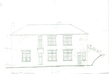
Plan, West Elevation of the Ballarat School of Mines Building Old Plumbing Building
... of the Chief Architect, S.C. Brittingham, Public Works Department... Architect, S.C. Brittingham, Public Works Department. Their initials ...This building was built in 1918-19 to a design by H.J. Kerr, District Architect (Western District), under the design control of the Chief Architect, S.C. Brittingham, Public Works Department. Their initials appear on the attached copy of the original drawing of the building. (Research by David Rowe)Copy of the Plumbing building on the grounds of the Ballarat School of Mines campusballarat school of mines, plans, building o, plumbing, old plumbing building, h.j. kerr, s.c. brittingham -
 Federation University Historical Collection
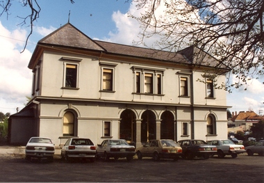
Photograph - Black and white sketch, Former Ballarat Supreme Courthouse (later Courthouse Theatre), c1994
... public works department... was erected by the Public Works Department in 1868. Early in the 1940s... by the Public Works Department in 1868. Early in the 1940s the former ...The former Ballarat Supreme Court building was unique in design for the time. The central court room and the flanking wings were all two storey with hipped roofs. This made this building different from other Public Works designs. The building was erected by the Public Works Department in 1868. Early in the 1940s the former Supreme Court was abandoned. Today the building is used as a performing arts centre.Colour photograph of the former Ballarat Supreme Court. This building did not follow the regular design for Public Works design. Central court room and adjacent wings are all two storey. The central section is recessed with ground floor arcade and arched windows. ballarat school of mines, former ballarat supreme courthouse, courthouse theatre, hipped roof, public works department, performing arts centre, legal -
 Federation University Historical Collection
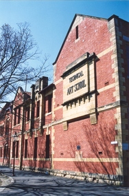
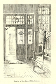
Photograph, Clare Gervasoni, Ballarat School of Mines Technical Art School, c2008, c2008
... Works Department from plans drawn by the then Art School... and was constructed by the Public Works Department from plans drawn ...The former Ballarat Circuit Court Building, later the first building of the Ballarat School of Mines, was demolished to make way for a new custom built Art School building. Sir Alexander Peacock opened the Ballarat Technical Art School in July 1915. It cost 10,000 pounds and was constructed by the Public Works Department from plans drawn by the then Art School Principal, Herbert H. Smith. The building contractors were Messrs Gower and Eddards. According to the SMB Annual Report of 1914 'the internal upholstering and fittings have all been carried out in Australian timbers, with Queensland maple largely used throughout.' Before this building was constructed art and craft classes were held in various buildings around Ballarat. The building could be described as federation-art deco in style. It features sandstone insertion with sandstone string coursing. The base of the building is rusticated sandstone. The relief stone panel on the front with the words "Technical Art School" features stone pilaster brackets and corbels. In the centre front can be seen rectangular sandstone pediment with decorative stonework incorporating the date of construction. The windows in the lower floor feature five supporting keystones whereas the upper windows have sandstone lintels. The building also features decorative cast iron downpipes. The entrance on the northern side has attractive leadlight glazing in an art deco style. Above the door a miner's lamp and pick are featured in the design. The building is functional in design with large metal windows in the south wall to ensure good light into the studios. The northern wall has standard double hung windows. The interior of the building features a carved wooden staircase and cast iron ceiling vents. The rear drawing studios can be made into one large studio by opening panelled timber doors. This opening features classical plaster pilasters with a pediment above.Colour photographs of a double storey, red brick building built - the Ballarat Technical Art School, a division of the Ballarat School of Minesballarat school of mines, ballarat technical art school, architecture, art, gribble building -
 Federation University Historical Collection
Artwork, other - Artwork, Artwork from the Ballarat School of Mines Students' Magazine, 1934, 1934
... by the Public Works Department from plans drawn by the then Art School... Works Department from plans drawn by the then Art School ...Sir Alexander Peacock opened the Ballarat Technical Art School in July 1915. It cost 10,000 pounds and was constructed by the Public Works Department from plans drawn by the then Art School Principal, Herbert H. Smith. The building contractors were Messrs Gower and Eddards. According to the SMB Annual Report of 1914 'the internal upholstering and fittings have all been carried out in Australian timbers, with Queensland maple largely used throughout.' Before this building was constructed art and craft classes were held in various buildings around Ballarat. The building could be described as federation-art deco in style. It features sandstone insertion with sandstone string coursing. The base of the building is rusticated sandstone. The relief stone panel on the front with the words "Technical Art School" features stone pilaster brackets and corbels. In the centre front can be seen rectangular sandstone pediment with decorative stonework incorporating the date of construction. The windows in the lower floor feature five supporting keystones whereas the upper windows have sandstone lintels. The building also features decorative cast iron downpipes. The entrance on the northern side has attractive leadlight glazing in an art deco style. Above the door a miner's lamp and pick are featured in the design. The building is functional in design with large metal windows in the south wall to ensure good light into the studios. The northern wall has standard double hung windows. The interior of the building features a carved wooden staircase and cast iron ceiling vents. The rear drawing studios can be made into one large studio by opening panelled timber doors. This opening features classical plaster pilasters with a pediment above. This building is now the Gribble Building on the Federation University Australia SMB Campus.Artwork by students of the Ballarat Technical Art School from the 1934 Ballarat School of Mines Students' Magazine .1) Stairs to the Ballarat Junior Technical School from Grant Street .2) Caricatures by Nornie Gude .3) work by Colin S. Hunt .4) A girl and a rooster by Gilda Gude .5) Self Portrait .6) Main entrance to the Ballarat Technical Art School by Lorna Bailey .7) Artwork from the magazineballarat technical art school, gribble building, gribble, stained glass, white flat, hopwood, bailey, gude, ballarat junior technical school, visual arts -
 Federation University Historical Collection
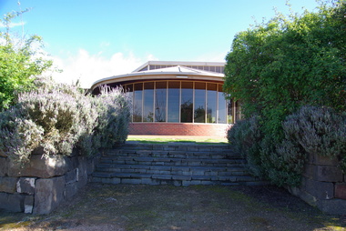
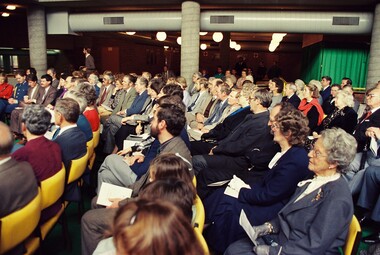
Photograph, Federation University Australia E.J. Tippett Library, 2013, 23/09/2013
... with the Public Works Department in association with the SMB Campus... for the building rested with the Public Works Department in association ...The E.J. Tippett Library is named after the late E.J. Tippett who was a long time President of the Ballarat School of Mines Council, and library advocate. In February 1985, the first sod for the new SMB Campus building was turned by the Minister for Planning and the Environment, the Hon. Evan Walker, M.P. The overall responsibility for the building rested with the Public Works Department in association with the SMB Campus architect, Ewan Jones & Associates and the builder, S. J. Weir Pty. Ltd. They put together the facility that is both functional and of a style that merges with the surrounding architecture. The new building was opened on 04 July 1986 by Governor of Victoria, His Excellency Dr Davis McCaughey.Two colour photographs showing the exterior of the E.J. Tippett Library at Federation University Australia SMB Campus, and two taken from inside the library looking over Ballarat East.e.j. tippett library, tippett library, smb library, tippett, e.j. tippett, ewan jones & associates -
 Flagstaff Hill Maritime Museum and Village
Award - Certificate of Service, F. W. Strahle, James Patten, 23-08-1907
This certificate acknowledges 21 years of service given by James Patten, one of the original 1859 Lifeboat Warrnambool as a boatman and bowman. At the time, all retiring Volunteer lifeboatmen were honoured with this award. It was made as a lithograph that was created by F. W. Strahle at the request of the Department of Lands & Survey, Melbourne, Victoria. During his time of service, James Patten was awarded a medal and certificate by the Royal Humane Society of Australasia for his bravery. Patten and his friend Joseph Lowe, who couldn't swim, were with their friend James Ferrier in a boat on the Hopkins River, Warrnambool, when their boat capsized. Ferrier made it to shore, and Patten tried unsuccessfully to hold onto Lowe and bring him to shore. The event occurred on 18th April 1890. The images on the Certificate show a collage of rescue events performed by the lifesavers; a shipwreck rescue in progress, lifeboat conveying five boatmen using two oars each, and a bowman standing at the bow, a linesman wearing a life jacket and holding a rescue line, a lifesaver ring with images of three sailing ships inside it, a shipwreck near shore, a woman and girl in shallow water, a rescue using a breeches buoy on the lifeline, two rescuers walking towards the survivor, rescue crew wearing waterproof clothing, a rocket machine with a pulley to bring the survivor in a breaches buoy to shore, and a rescue crew member holding a flare. Volunteers at the time received a small payment, or 'retainer'', for their practices and a payment of gratitude for the rescues they attended. Across the years between 1856 to 1979 the combined service in Victoria saved 260 lives. Amazingly, some of the volunteers could not even swim.This certificate shows the State and Local Government's appreciation for the years of service spent by in the endeavour to save lives in peril in and on the local waters in the early 20th Century. The lithographed design depicts the many skills and services performed by the lifesavers of the era.Certificate of Service, unframed, awarded to James Patten on 23rd August 1907, recognising his 21 years of service with the original Warrnambool Life Boat Service as a Boatman and Bowman. Certificate is on rectangular, cream paper, lithographed design, printed and handwritten. Letterhead with the Royal Coat of Arms of the United Kingdom and a French motto. Images depict lifesaving crew, lifeboat, rescue equipment and a rescue in progress. The border is waves inside of frame of looped rope. Signatures of Commissioner of Public Works, Secretary of Public Works, and Engineer in charge of Ports and Harbours, Melbourne. Printed from a lithograph produced by F.W. Strahle on 23rd June 1907.MOTTO: "Dieu Droit Et Mon, Ni Soit Qui Mal y" TREXT: "Certificate granted to James Patten as a mark of appreciation of his esteemed services of 21 years as Boatman and Bowman connected with the Departmental Life-Boat service at Warrnambool - dated the 23rd day of August 1907." SIGNATURES: [Commissioner of Public Works], [Secretary of Public Works], [Engineer in charge of Ports and Harbours Melbourne] "Lithographed at the Dept of Lands & Survey - Melb/ by F.W. Strahle, 23.6.07"flagstaff hill, warrnambool, flagstaff-hill, maritime museum, maritime village, shipwreck-coast, flagstaff hill maritime museum & village, james patten, life-saving, lifesaving, rescue, bravery, drowning, joseph lowe, james ferrier, hopkins river, boat accident, certificate of service, 1890, 1907, bowman, boatman, departmental life-boat service, life-boat service, lifeboat service, august 1907, commissioner of public works, public works, ports and harbours melbourne, lands & survey melbourne, f w strahle, lithograph, 1856-1979, 260 lives saved, victorian volunteers, lifeboatmen, retired lifeboatmen -
Federation University Historical Collection
Book, Ballarat School of Mines Stage 2 Concept Proposal, 1983, 05/1983
... public works department of victoria... public works department of victoria ballarat school of mines ...tafe, public works department of victoria, ballarat school of mines, population, objectives, programmes, plans, master plan -
Federation University Historical Collection
Book - Report, Ballarat School of Mines Stage 2 Concept Proposal, 1983, 05/1983
... public works department of victoria... University Australia. tafe public works department of victoria ...The Ballarat School of Mines is a predecessor institution of Federation University Australia. Blue plastic spiral bound reporttafe, public works department of victoria, ballarat school of mines, population, objectives, programmes, plans, master plan, campus plan, ballarat school of mines campus -
 Federation University Historical Collection
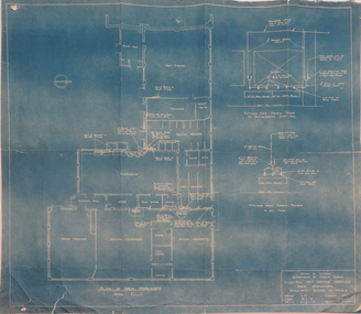
Plan, Blueprint: Electric Hot Water Services, Ballarat School of MInes New Workshops, 1947
... public works department of victoria... public works department of victoria archectural plans Plan ...The Ballarat School of Mines is now part of Federation UniversityPlan (blueprint) for electric hot water services to new Ballarat School of Mines workshops ballarat school of mines, new workshops, electric hot water service, public works department of victoria, archectural plans -
 Federation University Historical Collection
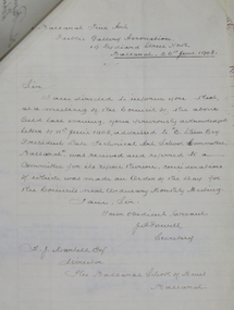
Letter - Correspondence, Inwards correspondence to the Ballarat School of Mines, 1908, 07/01908
The Ballarat School of Mines was the first school of Mines in Australasia, and was established in 1870. It is a predecessor institution of Federation University Australia.Correspondence to the Ballarat School of Mines for the month of July 1908. Letter 162 Ballarat Fine Art Public Gallery Association 19 Lydiard Street North Ballarat, 26th June 1908 Sir, I am directed to inform you that at a meeting of the Council of the above held last evening, your previously acknowledged letter of 11th June 1908, addressted to "E. [Stoer?] Esq, President Late Technical Art School Committee", was received and referred to a committee for its report thereon, cousi directions of which was made are the Order of the Day for the Councils next Ordinary Monthly Meeting. I am, Sir, Your Obedient Servant, J.A. Powell Secretary F.J. Martell Esq Director The Ballarat School of Mines Ballarat ballarat school of mines, frederick martell, ballarat fine art gallery, j.a. powell, art gallery of ballarat, gallery association, charles j. morris, ballarat fine art public gallery association, telegram, c.h. clark, l. ditchburn, alumni, examinations, w.g. taylor, london bank of australia limited, bealiba, thomas r. lyle, jessie chalmers, signor steffani, arundel orchard, w.f. coltman, e.e. hobson, j.t. mooney, queanbeyan, p.e. marmion, willaim m. robertson, assay, e.e. brook, lloyd copper mines, h.b. silberberg & co., education department melbourne, c. james, w. west, haddon, warragul, bakers reef gold mning company, letterhead, victorian portland cement works, d. mitchell, electric lighting and traction co. australia ltd, austral otis engineering comapny ltd, melbourne glass bottle works company, cuming, smith & co. pty ltd, excursions, metropolitan gas company, jaques bros manufacturing engineers, victoria iron works, a. victor leggo co, leggo's metallurgical works, melbourne hydraulic power company limited, mount lyell mining and railway coy ltd, victorian railways, telegraph, land surveying, j. brittain, g. fitzgerald, hamilton, cochran and co, wynne-grant antimony reduction company, mt egerton and gordons mining co, e. hogan, e.c. connell, a.d. galoway, metallurgy, h.b. silberberg, specific gravity balance and weights, union bank of australia (ballarat), bullarto, bush inn, bullarto, w. harrington, prospective student, book donaton from smithsonian institution, e. la t. armstrong, department of mines and forests, melbourne, snake valley, r. hall-jones, c. calaby, clementston, thomas ramsay, w.d. thompson, longmans, green and co, selwyn chase, missionary exhibition, aboriginal court of the missionary exhibition, examination results, leslie coulter, hnery j. saw, thomas ramsay, virgil tucker, leslie c. blick, thomas r. williams, oliver w. williams, thomas r. williams, leo m. seward, david w. bonar, louis w.g. buchner, leo m. seward, albert j. robin, james a. chambers, james d. brokenshire, william kingston, edgar c. hurdsfield, virgil tucker, oliver w. williams, william g. sides, herbert hawkesworth, colin c. corrie, henry j. saw, thomas h. trengrove, thomas r. prigdeon, harold b. herbert, viola p. jackson, lionel s. davies, stanley w. tompkins, arthur m. lilburne -
Federation University Historical Collection
Booklet, Report on the Viability of Establishing a Post Secondary Education Facility Located at the Aradale Traininf Centre, Ararat, Victoria, 1993, 12/1993
... in the Victorian Italianate style by John James Clark of the Public Works... style by John James Clark of the Public Works Department ...Aradale is located 3 km from the centre of Ararat and covers approximately 101 hectares. It consistes of an impresive group of mainly heritage buildings of national significance surrounded by open farmland. Aradale was designed in 1864 in the Victorian Italianate style by John James Clark of the Public Works Department, Victoria. A three storey nurses quarters was built in the 1930s and the Forensic Psychaitry Centre was established in the 1980s. The design of asylums as a specific building type orginated in England in the mddle of the 19th century when it was decided that 'pauper lunatics' would be better cared for in a separate institution rather than being house within the workhouses. Some of the early purpose built asylums were based on the radiating principle of prisons but the arrangement of separat wings at right angles used in hospitals and whorkhouse design soon came to be seen as the most appropriate. The largest 19th century asylum in England was built at Colney Hatch. Kew, Beechworth and Ararat Asylums closely followed the Colney Hatch model. In victoria the population rose due to the gold rushes resulting in severe housing shortages, and additional pressure on asylums. The first asylum in Melbourne was established at Y arra Bend. In 1862 a new asylum was established at Kew. Ararat Asylum and Beechworth Asylum were designed in 1864. Ararat was opened on 19 October 1867, with Beechworth Asylum opening five days later. Soft covered bookletararat regional development board inc., aradale training centre, aradale, grano street ararat, alfred st ararat, ivar nelson, john christie, jon duggan, wes matthews, peter helfer, michael burke, john grant, asylum, lunatic asylum, colney hatch asylum, ararat asylum, fever tents, sunbury asylum, kew asylum, beechworth asylum, wine industry training -
 Federation University Historical Collection
Letter - Correspondence - Education Department, Victoria, Ballarat School of Mines Museum Building, 29/08/1951
Public Works to submit a report regarding wiring diagram - sub-boards for Museum BuildingTyped letter on paper, with handwritten annotationsballarat school of mines, museum building, wiring, d h wheeler, education department of victoria, d.h. wheeler -
 Federation University Historical Collection
Photograph, Opening of the E.J. Tippett Library at the Ballarat School of Mines, 1986, 04/07/1986
... with the Public Works Department in association with the SMB Campus... for the building rested with the Public Works Department in association ...The E.J. Tippett Library is named after the late E.J. Tippett who was a long time President of the Ballarat School of Mines Council, and library advocate. In February 1985, the first sod for the new SMB Campus building was turned by the Minister for Planning and the Environment, the Hon. Evan Walker, M.P. The overall responsibility for the building rested with the Public Works Department in association with the SMB Campus architect, Ewan Jones & Associates and the builder, S. J. Weir Pty. Ltd. They put together the facility that is both functional and of a style that merges with the surrounding architecture. The new building was opened on 04 July 1986 by Governor of Victoria, His Excellency Dr Davis McCaughey.Photographs of the opening ceremony at the E.J. Tippett Library. e.j. tippett library, library, e.j. tippett, library catalogue cards, ewan jones and associates, smb library, ballarat school of mines -
 Federation University Historical Collection
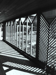
Photograph - Photograph - Black and White, View from E.J. Tippett Library
... with the Public Works Department in association with the SMB Campus... for the building rested with the Public Works Department in association ...The E.J. Tippett Library is named after the late E.J. Tippett who was a long time President of the Ballarat School of Mines Council, and library advocate. In February 1985, the first sod for the new SMB Campus building was turned by the Minister for Planning and the Environment, the Hon. Evan Walker, M.P. The overall responsibility for the building rested with the Public Works Department in association with the SMB Campus architect, Ewan Jones & Associates and the builder, S. J. Weir Pty. Ltd. They put together the facility that is both functional and of a style that merges with the surrounding architecture. The new building was opened on 04 July 1986 by Governor of Victoria, His Excellency Dr Davis McCaughey.Black and white photo taken from outside the Tippett Building, showing the wood pattern at the entranceballarat school of mines and industries, tippett building, ballarat school of mines, library, buildings, ewan jones and associates, e.j. tippett library, smb library -
 Flagstaff Hill Maritime Museum and Village
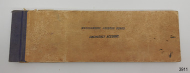
Financial record - Bank Deposit Book, Commercial Banking Company of Sydney Limited, Pre Jan, 1932
... Public works department... of the Public Works Department of Victoria. The Board... the Public Works Department again had control. The Warrnambool ...This bank deposit book was used for financial deposits made between1932 and 1936. The funds were deposited into the Emergency Account of the Warrnambool Harbour Board, lodged at the Warrnambool Branch of the Commercial Banking Company of Sydney Limited (CBC). James Menzies, Pilot and Harbour Master from 1929, would have used this deposit book when he was appointed as Acting Secretary of the Warrnambool Harbour Board in 1932. He held this office until the Board ceased in 1936. Warrnambool’s CBC Manager during this time was L E Whitney; he was Manager from 1924 to 1939. The Commercial Banking Company of Sydney Limited opened in 1893. On January 1, 1927 the CBC amalgamated with the Bank of Victoria. In 1981 the CBC merged with the National Bank of Australasia Limited and on January 1, 1983 the bank started using the abbreviated name of the National Australia Bank (NAB). Warrnambool Harbour Board The Warrnambool Harbour Board was constituted by Order of Council on May 29, 1928, under the Harbour Board’s Act of 1927, taking over from the Ports and Harbours Branch of the Public Works Department of Victoria. The Board was then the only body with power to manage and control the whole Port, including shipping, facilities upkeep and improvements of the port. The work it carried out involved dredging, building of port facilities and drafting of port regulations, and collecting taxes, tolls, rates and charges. The Board was officially dissolved on June 30, 1936, at which time the Public Works Department again had control. The Warrnambool Harbour Board had rented out the Lighthouse Keeper’s Quarters from the 1920s until 1936, when the Board closed down. However, rentals continued with other currently unknown landlords until Flagstaff Hill Maritime Village opened in 1975 and began renovating the Cottage, in stages. This financial record book is significant for its association with the historic financial records of the Warrnambool Harbour Board and relates to the maritime history of Warrnambool, in particular with the Port of Warrnambool.Warrnambool Harbour Board Emergency Account Book containing deposit receipts and blank forms for the Commercial Banking Company of Sydney Limited. Rectangular book has buff coloured card covers, white pages with pre-printed text and lines and black tape binding on left side. Inscriptions stamped on front cover, receipts and unused, pre-printed pages. Approximately half of the pages have been filled in, and the deposit slips removed, leaving the receipt end attached to the book. There are two lose receipts stapled into the book. Hand written receipts date from 21 JAN 1932 to 25 JULY 1936. Stamped "WARRNAMBOOL HARBOUR BOARD / EMERGENCY ACCOUNT" "WARRNAMBOOL VIC" "EMERGENCY ACCOUNT / WARRNAMBOOL HARBOUR BOARD" Also, each receipt has the bank's stamp with its details and the date on it. Hand written details are on each completed receipt.warrnambool, shipwrecked-coast, flagstaff-hill, flagstaff-hill-maritime-museum, maritime-museum, shipwreck-coast, flagstaff-hill-maritime-village, shipwrecked-artefact, book, warrnambool harbour board, emergency account, commercial banking company os sydney ltd, bank deposit book, financial record, financial management, stationery, deposit book, public works department, ports and harbours, commercial banking company of sydney ltd., james menzies, harbour master, l e whitney, cbc manager warrnambool, harbour board act, port of warrnambool, warrnambool harbour, lady bay, harbour pilot -
 Bendigo Historical Society Inc.
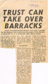
Newspaper - LA TROBE UNIVERSITY BENDIGO COLLECTION: BENDIGO POLICE BARRACKS
... Public Works Department... Bendigo history history Public Works Department Education ...A newspaper article advising that the National Trust has been handed the original Police Barracks in Bendigo in order to preserve the historical property. Bendigo ' Advertiser ' 25th June 1973.bendigo, history, police barracks, la trobe university bendigo collection, collection, national trust, bendigo, police barracks bendigo, bendigo history, history, public works department, education department victoria, bendigo teachers' college, place, site, tertiary education, teacher training -
 Bendigo Historical Society Inc.
Document - BENDIGO SCHOOLS COLLECTION: BENDIGO HIGH SCHOOL
Three pages typewritten document on the history of Bendigo High School. Also a letter dated 27th July, 1966 from Public Work Department to Mr. g. Duck, North Western D.A. Signed L. Donegan Senior Inspector of Works.school, history, bendigo high school -
 Bendigo Historical Society Inc.
Document - NORMAN OLIVER COLLECTION: SPEECH NOTES 4 JULY 1951
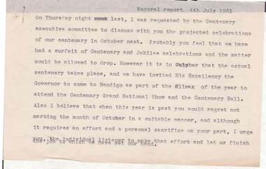
... : Bendigo Centenary, the Public Works Department, traffic control...'. Topics include : Bendigo Centenary, the Public Works Department ...The Norman Oliver collection. Norman Oliver was three times Mayor of Bendigo - 1950-51, 1964-65, 1970-71. Fifteen typed pages headed Mayoral Report 4th July 1951. In the format he used for his weekly talk on 3BO 'The Mayor Speaks'. Topics include : Bendigo Centenary, the Public Works Department, traffic control, taxi size and rules, expenditure without notice of motion, town planning, and bus services.bendigo, council, speech notes, norman joseph oliver , councillor norman oliver. mayor of bendigo. 3bo 'the mayor speaks'. bendigo centenary 1951. -
Port Melbourne Historical & Preservation Society
Book - Borough of Sandridge, Public Works Committee May 1862 to March 1864, 1862 - 1864
Minutes of the Borough of Sandridge Public Works Committee 1862 - 64. Similar in appearance to other Sandridge committee minutes, but much larger.local government - borough of sandridge, engineering department - borough of sandridge -
Port Melbourne Historical & Preservation Society
Letter - Public Works Department re new bridge over Yarra at Swanston Street, Public Works Department, 19 May 1880
... Public Works Department re new bridge over Yarra at...Letter from Public Works Department, 1880, on conference...Public Works Department... Public Works Department, 1880, on conference regarding new bridge ...Letter from Public Works Department, 1880, on conference regarding new bridge over Yarra at Swanston Streetengineering - bridges, town planning, michael tarver quinn -
Bendigo Historical Society Inc.
Document - HARRY BIGGS COLLECTION: OLD POLICE BARRACKS, 5/6/70
... Works Department Victoria letterhead from G. Serpell Director... Collection. A letter on Public Works Department Victoria letterhead ...Document. Harry Biggs Collection. A letter on Public Works Department Victoria letterhead from G. Serpell Director General to Mr H. Biggs, Treasurer Royal Historical of Victoria (Bendigo Branch) dated 5th June 1970. In the letter he is stating The Depart. Of Crown Lands & Survey is investigating the future use & control of the old Police Barracks building.G. Serpell Director Generalorganization, club/society, community, harry biggs collection, old police barracks -
Bendigo Historical Society Inc.
Document - HARRY BIGGS COLLECTION: OLD POLICE BARRACKS, 14/5/1970
Document. Harry Biggs Collection. A typewritten letter on Education Department Victoria letterhead dated 14/5/1970 from L. H. S. Thomson, Minister of Education to Mr. Trethewey telling him that because of the state of the Old Police Barracks he has no option but to ask the Public Works to arrange for the demolition of the Barracks.L. H. S. Thomsonorganization, club/society, community, harry biggs collection, old police barracks -
NMIT (Northern Melbourne Institute of TAFE)
Book: Furniture and equipment layouts for TAFE colleges Victoria. 1981
... A4 size loose pages published by the Public Works... NMIT A4 size loose pages published by the Public Works ...A4 size loose pages published by the Public Works Department and the Education Department Victoria in 1981. The contents cover the following Colleges: Moorabin, Dandenong, Collingwood, Newport, Box Hill, Sunraysia, Yallourn, Footscray, RMIT, Preston, School of Mines & Industries Ballarat, McMillan Rural Studies, Loddon Valley Bendigo, Wangaratta and Latrobe Street Complex. Plans and diagrams included.manuals, tafe colleges, preston technical college, collingwood tedhnical college, nmit -
 St Kilda Historical Society
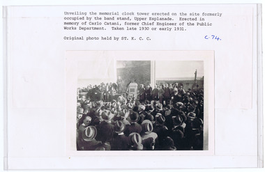
Photograph, Carlo Catani Memorial Clock Tower unveiling, c1930, c. 1930-1931
... in memory of Carlo Catani, former Chief Engineer of the Public Works... of Carlo Catani, former Chief Engineer of the Public Works ...Upper Esplanade, St Kildablack and white photograph, original, mounted, good conditionUnveiling the memorial clock tower erected on the site formerly occupied by the bandstand, Upper Esplanade. Erected in memory of Carlo Catani, former Chief Engineer of the Public Works Department. Taken late 1930 or early 1931. Original photo held by St.K.C.C' c.74 -
 Robin Boyd Foundation
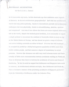
Document - Manuscript, Robin Boyd, Australian Architecture, 1971
Discussion of Architectural professional techniques (organisation of the profession, from the societies, registration etc and the growth in the profession, office practices) public and private practices (eg Commonwealth Department of Works,), research and regulations (eg building research, CSIRO), and theory and practice (the vernacular, the professional and the creative).Original manuscript of an article published as 'Architecture in Australia’ in RIBA Journal, Vol.78, No.1, January 1971, pp.11-20.Typewritten (p/copy), quarto, 22 pagesaustralian architecture, royal australian institute of architects, the architecture profession, package dealing, australian architecture students association, public and private practice, commonwealth department of works, building research, csiro, building regulations, john andrews, robin boyd, manuscript -
 Robin Boyd Foundation
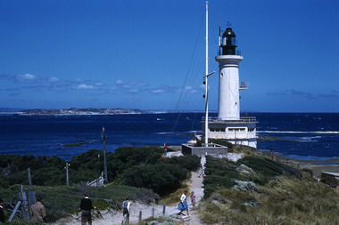
Slide, Robin Boyd, 1959
... . (Architect: Victorian Public Works Department.)... Works Department.) Slide Robin Boyd ...Colour slide in a mount. Point Lonsdale Lighthouse. (Architect: Victorian Public Works Department.)Made in England / 16 / 59 (Handwritten) -
University of Melbourne, Burnley Campus Archives
Article - Photocopy, Horticultural Society of Victoria, 1860
Photocopy of Newspaper Article, Thursday 2 August, 1860 p 7 Report of the monthly meeting of the HSV Municipal Council of Richmond and commissioner of Public Works had granted funds for fencing the gardens and plans for a special meeting as soon as the Department of Lands had granted them land in the Surrey Paddock.Newspaper article from The Argusthe argus, surrey paddock, burnley gardens, horticultural society of victoria, hsv -
 University of Melbourne, Burnley Campus Archives
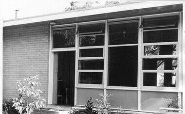
Photograph - Black and white print, Canteen & Recreation Room, 1961
... public works department... Room built by P.W.D. (Public Works Department) with funds..., "Canteen & Recreation Room built by P.W.D. (Public Works Department ...Note by T.H. Kneen 19 November 1991, "Canteen & Recreation Room built by P.W.D. (Public Works Department) with funds provided by Burnley Horticultural College Ladies' Committee (in 1962?). The paving was carried out by students under direction of George Grumont." (Mechanics, Carpentry and Building Construction).Black and white photograph. Canteen and recreation room.canteen, recreation room, george grumont, burnley horticultural college ladies' committee, students working outside, public works department, paving