Showing 672 items
matching junction road
-
 Ringwood and District Historical Society
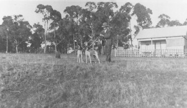
Photograph, First house built in Junction Street, Ringwood, near Mullum Mullum creek (undated)
Man with two dogs in front.Written on backing sheet, "First house built in Junction Street, near creek". -
 Ringwood and District Historical Society
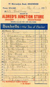
Document, Invoices from Aldred's Junction Store, Ringwood
Three invoices "Bushell's" advertising on each invoice from Aldred's Junction Store. Selling groceries and delicatessen, "orders called for and delivered". Phone WU 6089, 91 Warrandyte Road, Ringwood. Invoiced to Mrs Pullin , dated 10th June 1953. Stamp Duty stamp of 2d value. Some products include Lux soap, butter, sugar, sausages, Maxum cheese (see https://australianfoodtimeline.com.au/1928-maxam-cheese-launched-in-queensland/), apricots, puffed wheat and margarine. Located at the corner of Loughnan and Warrandyte Roads. -
 Ringwood and District Historical Society
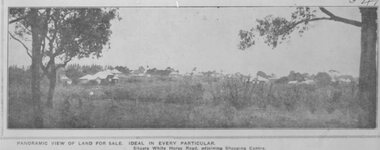
Pamphlet, G.A. Green, Auction Sale Brochure - Garden Farms Estate, Ringwood, Victoria - 1919, 1919
Multi-fold brochure advertising public auction of one-acre, 2-acre, 5-acre and 8-acre allotments in Ringwood and Bayswater on Saturday 12th April, 1919. Brochure includes terms of sale, description of subdivision features and local facilities, and photographic images of the area.Subdivison includes Canterbury Road Heathmont, Armstrong Road Heathmont, Armstrong Road Bayswater, Bungalook Road Heathmont, Bungalook Road Bayswater, and Orchard Road Bayswater. Road shown as Bayswater Road to Bayswater became Mountain Highway Bayswater. Vendor: H.E.B.Armstrong, Auctioneers: Coghill & Haughton, 79 Swanston Street Melbourne, Telephone Central 2793, in conjunction with J.B. McAlpin, Ringwood, Opposite Station, Telephone Ringwood 7. (Map) Woodcock & McCormack, Civil Engineers Architects & Surveyors, 430 Little Collins Street, Melbourne, Phone 3241 Central. MOST OF THE MONEY COMES OUT OF THE LAND. And more money can be obtained from anb acre of fruit than from an acre of any other produce. But you do not have to grow fruit on Garden Farms Estate. You can go in for - Outer Suburban Home - Market Garden - Orchard - Pig Raising - Poultry Farm - Small Dairy Farm - Small Fruits - Floral Culture - Scent and Bee Farm - Or just for a Week-end Home. RINGWOOD - THE PLACE TO LIVE. The Beautiful Ringwood District has so many natural attractions, that half a Land Agent's work is done in just showing a prospective buyer round and about. Ringwood has a pull of its own that attracts folk, proved beyond doubt by its rapid development within the last decade (spite the war). First, it is high and healthy, picturesque and undulating, convenient of access, sufficiently close to the Metropolis for City and Business folk to live at Ringwood. Its development is solid, because most of its people are industrious husbandmen, real producers, who have turned idle hills into smiling gardens. These are the kind of real people to live amongst; ones who wear out their spades. The rapidly-developing town has excellent Stores, Trade and Repair Shops Churches, Banks, Telephone Exchange, Weekly General Market, Cool Stores, and good Private and State Schools, etc.; is Electrically lit, has Metropolitan Water Supply, and generally provides so that practically all shopping can be done locally. WHY RINGWOOD MUST GROW. Ringwood is a great centre and must be a greater. Two rapidly-developing railways junction here. The passengers from Ringwood Station cityward, in one year, number 250,000. Ringwood will be the terminus of the Outer Suburban Electric Eastern Railway. Its natural boundaries are the River Yarra on the North, Dandenong Creek on the South, the popular town of Croydon on the East, and the suburb of Mitcham on the West. This is a large territory that is steadily being converted from intense culture, and then it might be called (as regards its gardens) "The Devon Territory of Victoria." ARMSTRONG ROAD. This new road traverses Garden Farms Estate from its northern boundary on the main Canterbury Road, across Dandenong Creek, to its southern boundary on the main Bayswater Road, and will provide a long-desired additional link of communication between Bayswater and Ringwood. The 1-acre building sites on Bayswater Road are within 8 minutes' walk of the Bayswater Railway Station, and the Canterbury Road frontages are only 1-1/2 miles from Ringwood Station, and 1/2 mile from the Railway Station site of Canterbury Road; therefore, the whole Estate is easy of access and there should be a large demand for land so favourably placed. (Image) Cultivation Field - Potatoes on Lot 28 (Image) Picture of Bayswater Creek Flats. (Image) View from "Korumbeen" where Mr. Armstrong lived on Garden Farms Estate. Estate outlined in white ring. (Image) Site of New Bridge over Dandenong Creek. (Image) On one of the timbered lots adjoining railway. (Image) This Dandenong Creek traveres the Estate. (Image) Main Fern Tree Gully Line bisects the Estate. -
 Ringwood and District Historical Society
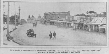
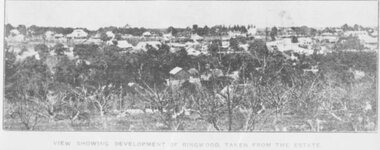
Photograph, Maroondah Highway Central, Ringwood. Ringwood Shopping Centre, Whitehorse Rd- 1924
Black and white photograph (3 copies) Typed below one photograph: "Ringwood Shopping Centre, Whitehorse Rd. - 1924". Typed below other copies: "Ringwood's progressive shopping centre. Growing busier every day. Pratt's Junction Estate is within Three Minutes of this Street". Typed on back of one copy: "Copied from a circular by F.V. Parker 24/11/23 advertising Pratts Junction Estate. 86 lots. Oliver St. Georges Rd. & Junction St., between Mullum Creek & Whitehorse Rd. £3 deposit and 1£ per month." -
 Ringwood and District Historical Society
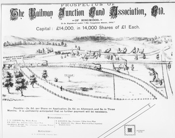
Photograph, Land sale prospectus - Railway Junction Land Association Ltd., Ringwood - circa 1890
Catalogue card reads, 'Early Sketch of Ringwood Layout (part). Not to scale but largely true to life of approximately 1890. Many local landmarks shown e.g. Wesleyan Chapel, Duncans Antimony Mine Hotel, Cass's School, Herry's Store. Maroondah Highway not shown but would approximate a line drawn from just to left of horse and cart near Chapel - North to pass around Antimony Mine and to the left to pass behind Cass's School.' -
 Ringwood and District Historical Society
Photograph, Image used for land sale promotion of Pratt's Junction Estate opposite Mount Dandenong Road, Ringwood - 24/11/1923
Catalogue card reads, "Pratt's Junction Estate - 24/11/1923, 86 lots". -
 Ringwood and District Historical Society
Photograph, Pratt's Junction Estate, Ringwood - 1923. Oliver St., Georges Rd., Junction St. 24/11/1923. 3 pounds deposit and 1 pound per month. F.V. Parker agent. 86 lots. Free rail tickets and motor transport
Catalogue card reads, "Pratt's Junction Estate 1923. Oliver St., Georges Rd., Junction St. 24/11/1923. 3 pounds deposit and 1 pound per month. F.V. Parker agent. 86 lots. Free rail tickets and motor transport." -
 Ringwood and District Historical Society
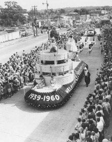
Photograph, Proclamation of the City of Ringwood procession - 19 March, 1960
Typed below photograph, 'Parade 1960 Maroondah Highway'. Catalogue card reads, 'Declaration of City. Float. Background. Left - site of demolished Cool Store corner of Maroondah H'way and Wantirna Rd. Clock Tower formerly at junction of Highway and Warrandyte Rd. moved to this site.' -
 Marysville & District Historical Society
Document (Item) - Document-Table, Judith Vimpani, Yarra Track Hostelries- Marysville to Woods Point, Unknown
A document outlining all the hostelries that existed along the Yarra Track between Marysville and Wood's Point.A document outling all the hostelries that existed along the Yarra Track between Marysville and Wood's Point.yarra track, marysville, wood's point, woods point, fernshaw, paradise plains, black spur, mount grant, george edwards, walker family, melbourne, new chum, hit & miss restaurant, mr clifford, michael woods, glen watts, tri bhean hotel, ewen cameron, ewen hugh cameron, thomas barton, butler's wood's point directory, globe hotel, swanston street, mount juliet, ben more & c, jordan district, jefferson's watts bridge inn, matthew jefferson, reefer's hotel, boyle's hotel, william henry johnson, samuel boyle, black spur hotel, fisher's creek, narbethong, fisher's home hotel, black spur inn, frederick fisher, william hodson, wood's point road, acheron river, acheron bridge hotel, john robson, granton, clifford, wilks creek, wilks creek hotel, patrick maloney, steavenson, marysville hotel, australian hotel, junction hotel, the dutchman's restaurant, henry kuyper, william podlech, mount arnold, mount arnold hotel, charles schultz, james toohey, john gleeson, joy burchall, ian newman, henry brockman, belle isle, belle elle, bellell creek, upper yarra, guerin's bridge, bell's hotel, henry petty, celia moran, ruth petty, cumberland creek, cumberland creek store and restaurant, cumberland creek hotel, charles edwin hargreaves, annie hargreaves, urina hargreaves, alice hargreaves, healesville, josiah hargreaves, henderson drysdale, henry whelan, halfway house, thomas smith, svendson, gosling, donovans creek, chesterville, perry's hotel, john perry, perry's coach and horses hotel, edward courtney, scandinavian hotel, the swede's, walker's hotel, jacob burchart, golden fleece, theodore kappler, george koehler's hotel, david walker, millicent walker, elsie jowett, bill walker, big river, royal mail hotel, shaw's, slingsby davies, edwin jones, elizabeth jane parker, sandridge, archibald charles edwin jones, matlock, alexander myers, frank berwick frederick jones, ned jones, jennie jones, sophie milllicent parker jones, thomas shaw, dorothy walker, travellers rest hotel, reefton, summers, john fehring, f fehring, katerina fehring, john christoph blumeyer, anne fehring, john baker, evelyn observer, anna katrina baker, hannah catherine baker, john frederick baker, mcmahon's creek, oaks, the springs, st clair, sinclair's valley, mountain home hotel, neilson, collins, waters, jan emma sinclair, john sinclair, mr cox, peter sinclair, willie we have missed you hotel, spring vale hotel, robert matthews, thomas crawford -
 Eltham District Historical Society Inc
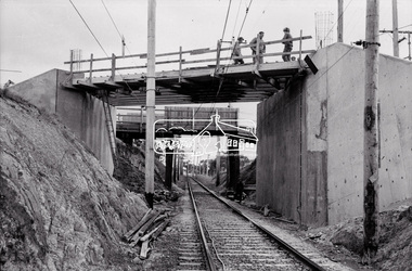
Negative - Photograph, Russell Yeoman, New road bridge under construction over railway line at junction of Sherbourne and Para Roads, Briar Hill, 1971
New bridge in foreground. Old bridge in background before demolition. This photo forms part of a collection of photographs gathered by the Shire of Eltham for their centenary project book,"Pioneers and Painters: 100 years of the Shire of Eltham" by Alan Marshall (1971). The collection of over 500 images is held in partnership between Eltham District Historical Society and Yarra Plenty Regional Library (Eltham Library) and is now formally known as the 'The Shire of Eltham Pioneers Photograph Collection.' It is significant in being the first community sourced collection representing the places and people of the Shire's first one hundred years.Digital image 35 mm B&W negativesepp, shire of eltham pioneers photograph collection, montmorency, briar hill, bridge, para road, railway bridge, railway line, road construction, sherbourne road, bridge construction -
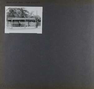 Glen Eira Historical Society
Album - Album page, Balaclava Road Tram Shelter, Circa 1972
... at the junction of Dandenong Road and Hawthorn Road, Caulfield ...This photograph is part of the Caulfield Historical Album 1972. This album was created in approximately 1972 as part of a project by the Caulfield Historical Society to assist in identifying buildings worthy of preservation. The album is related to a Survey the Caulfield Historical Society developed in collaboration with the National Trust of Australia (Victoria) and Caulfield City Council to identify historic buildings within the City of Caulfield that warranted the protection of a National Trust Classification. Principal photographer thought to be Trevor Hart, member of Caulfield Historical Society. Most photographs were taken between 1966-1972 with a small number of photographs being older and from unknown sources. All photographs are black and white except where stated, with 386 photographs over 198 pages. From Victorian Heritage Database citation H0174 TRAM VERANDAH SHELTER CORNER BALACLAVA AND ORRONG ROADS CAULFIELD NORTH - Vic Heritage Register https://vhd.heritagecouncil.vic.gov.au/places/2721 (as at 28/10/2020) The waiting shelter at the corner of Balaclava Road and Orrong Road, Caulfield was constructed in 1916/17 for the Prahran and Malvern Tramways Trust and is one of only three remaining tram shelters in Melbourne designed in the form of a verandah. The shelter has a corrugated iron roof fixed to an angle iron roof frame. The roof, which extends in the form of a skillion over the pavement, is supported on three squared, chamfered timber posts at the rear and three cast iron reeded columns with round bases and Corinthian capitals at the front. (The columns are hollow and function as downpipes, with rainwater discharging from the verandah roof, through the columns and under the ground). The shelter has a rinceau pattern frieze along the road frontage with centrally placed shield motif (which does not contain a coat of arms). The side and rear panels are lined with ripple iron and the upper panel at the rear is lattice work. The shelter has two timber slatted bench seats.From Victorian Heritage Database citation for H0174 TRAM VERANDAH SHELTER CORNER BALACLAVA AND ORRONG ROADS CAULFIELD NORTH - Vic Heritage Register https://vhd.heritagecouncil.vic.gov.au/places/2721 (as at 28/10/2020) How is it significant? The waiting shelter at the corner of Balaclava Road and Orrong Road, Caulfield is of historical and architectural significance to the State of Victoria. Why is it significant? The waiting shelter is of historical significance for its association with the development of the suburban (electric) tram network which assisted the expansion of Melbourne as a suburban metropolis. It is also of historical significance for its connection with the Prahran & Malvern Tramways Trust. The Prahran & Malvern Tramways Trust (1907-1920) was the first municipal electric tramway in Melbourne, becoming the largest and most successful of all the municipal tramway trusts. Its services played a key role in facilitating suburban expansion and the development of the southern and eastern suburbs. The growth of tramways was one of the greatest municipal developments in Victoria during the first decade of the twentieth century. The waiting shelter is an important remnant of this period of Melbourne's transport history and a tangible reminder of the Prahran & Malvern Tramways Trust. The shelter indicates the extent of the Prahran & Malvern tram network. The waiting shelter at corner of Balaclava Road and Orrong Road, Caulfield is one of only three remaining tram shelters in Melbourne designed in the form of a verandah. The waiting shelter is of architectural significance for the distinctive design and construction which is unique to the Prahran & Malvern Tramway Trust tram network. The shelter was designed by notable Melbourne architect Leonard J. Flannagan (1864-1946). Flannagan was responsible for a number of buildings for the Prahran and Malvern Tramways Trust including the early waiting shelter at the junction of Dandenong Road and Hawthorn Road, Caulfield, and sections of the tram depot at Malvern, and also designed a depot for the Hawthorn Tramways Trust. The waiting shelter, a conservative design influenced by Victorian architecture, is based on the Melbourne City Council late 19th century standard cast iron verandah. It is of significance as an intact example of the cast iron type shelter and for its detail, including Corinthian columns and a 'rinceau' pattern cast-iron frieze. The shelter is largely in keeping with the original design and retains its integrity. The cast iron waiting shelter is also of significance as an unusual example of early twentieth century street architecture. Page 155 of Photograph Album with one landscape photograph of a tram shelter on Balaclava Road.Handwritten: BALACLAVA ROAD TRAM SHELTER [top] / 155 [bottom left]trevor hart, verandah, garden, grimwade house, grimwade, orrong road, balaclava road, melbourne grammar, melbourne grammar junior school, mgs, m.g.s, school, tram shelter, waiting shelter, prahran & malvern tramway trust, leonard j. flannagan, cast iron verandah, cast iron type shelter, corinthian columns, 'rinceau' pattern cast-iron frieze, rinceau, cast iron frieze, victorian style, caulfield north, leonard flanagan, cast iron work, prahran and malvern tramways trust, trams -
Glen Eira Historical Society
Document - CUMBERNAULD
This file contains nine pages about people related to this property: 1/Copy and pasted eight pages taken from Census Records and Trove items. Articles include the death of Thomas Livingstone Cleland during WWI. Various social notes regarding his family up to 1953. There are articles on the W.J. Mathieson family, who also resided there, as well as residing in Benalla. 2/Print from Trove of an article from the 23/11/1934 edition of The North Eastern Ensign (Benalla, Vic) about the wedding anniversary of Mr and Mrs W.J. Mathieson, held at Cumbernauld on 27/10/1934.cumbernauld, thornleigh grange, house names, cleland thomas livingstone, cleland annie, gardeners market, clayton road, ‘hillside’, caulfield, anderson street, cleland sydney, cleland margaret, cleland james, cleland adelaide, cleland robert, cleland bessie adelaide, cleland agnes, cleland lily, cleland alick douglas milkman, cleland aggie, cleland tom h.s. draftsman, cleland kenneth malcolm, cleland ethel, cleland hector, cleland edna may, mathieson w.j., mathieson isabel, burrows f.a. lieut., east st. kilda, hawthorn road, ‘thornleigh grange’, south caulfield progress association, south caulfield junction, caulfield court, jenkins harry, giles alfred, grafton street, elsternwick, dawes john, chloris crescent, st. john’s presbyterian church, mathieson evelyn mary, marks theodore leslie, mathieson kitty, masonic hall, st. george’s road, haverfield frank, haverfield mrs, haverfield robert ross, rynn mary buckley, cyclists, cycling, donald alexander, martin lottie, whitelaw joan, trinity hall, brighton road, gilmore patricia phyllis, brooklyn ave., point nepean road, north road, brighton court, cleland nora, seaview drive, cleland john stuart, mathieson isabella cristina, kalymna grove, mathieson catherine m., tailor, mathieson william james, councillors, social events and activities, births deaths and marriages, anniversaries, world war 1914-18, soldiers -
Glen Eira Historical Society
Document - LECHTE, WILLIAM LUDWIG SAMUEL SEBASTION
3 items about this person: 1/Two twelve page carbon copied documents, purportedly written by William Letchte, son of George, written in c1935/36. He writes of his jobs as a dairyman, cow minder at the age of ten tears. He recollects streets, people, residences, business and general landscape in the area, as he takes you on a tour of the area. 2/Photocopied photo of Katrina Lechte (nee Bolch?) donated by Ian Lechte, 15 Adrian Street, East Bentleigh. 3/Photocopied copy of first pages and cover of William Lechte’s booklet on ‘Caulfield 1869 – 1935 Memories of the Past’, published by the City of Caulfield, 1992. The Society has the full booklet in its book collection (not yet catalogued as of 07/07/2015).grange road, glenhuntly, glen huntly station, alma road, dairies, caulfield park, swamp, queens avenue, station street, cross street, racecourse, heywood j. g., turf club hotel, dandenong road, royal hotel, koornang road, north road, murrumbeena road, mclaurin archibald, crosbie j. w., poath road, newton mr., hooker mr., peck family robert farmer, dairies, ross murray, rosstown, hansen hans, arnott family, peppin family, ormond station, malane family, fraser simon, overtons, shepherds, spring road, mohlers, brighton cemetery, mall kim, market gardeners, long john farmer, fiedler mr., booran road, reservoir, summers mr., maddocks mr., holland mr., caulfield council, glen eira road, harriman benjamin c., kambrook road, bambra road, princess park, marriott john, hawthorn road, brickworks, hyam mr., cottages, jasmine street, sycamore street, paddy o’briens swamp, arnold tom, london tavern hotel, guess john-grocer, topp mr., poath road, pine trees, colonel le marehand, balaclava junction, chemist shop, bell mr., nicholls mr. william h., wine shop, orme mr., pepperorn mr. john, balaclava road, orchards, harvey mr. robert tailor, schubert mr., blew charlie – gardener, philpott mr. richard b., farquhar mr. william farmer, newing t. r., glen eira road, payne john, brockhoft mr., dickson mr. james, snipe t., bevan mr., mckean family john, murray family, francis mr., hart mr., mcdougall james, brady peter, cad, elsternwick station, webb mr., masters mr. samuel, master street, ford mr., anderson mr. joseph gardener, slaney mr., boxhill mr. richard, post office, newsagent, hotham street, service james, bunn mr., sargood mr., orrong road, arnold tom – dairy, officer mr., grimwade mr., alexandra street, oakleigh hall, degraves mr., wilson samuel, ‘manifold’, house names, miller septimus, alma road, knox mr. james gardener, smith mr., coachman, ‘cumloden’, lange mr., holyrood justice mr., cronin mrs. mary, mcgivenys dairy, ‘belle vista’, lloyd c. d., caulfield council, hughes mr., armstrong j. a., tom healey’s market garden, kooyong road, inkerman road, tom roe’s market garden, mcleod captain, daish captain, plumridger mr. frederick, gardeners, tester mr. thomas, kent mr., kent g., fiddes mr., billings mr., semple mr., fosberry mr., howitt or., merrett mr., orchards, hawthorn road, hines mr., ‘rosecraddock’, langdon h. j., ‘crotonhurst’, webb justice mr., renwick s., ‘garrell’, barry mr., drinsdale family, st. mary’s church, sunday school, newing miss, teachers, stephen justice mr., stephen wilberforce, mount l., grimwade’s, ‘grimwade house’, danby’s, spence mr., venables family, mr. moss’ congregational church, barnhill mrs., porter miss, webb’s, ferguson, orange, police stations, kooyong road, pennington mr., health inspectors, engineers, inkley mr., farriers, mckeon mr., ‘sylverly’, dixon mr. edward, turner mr., marriott robert, ‘ravenhurst’, thompson j. j., wott t., architects, perrin mr. francis, tennis courts, royal parade, sayce mr. joseph j. p., ricketson h., ‘glen eira’, mansions, hospitals, turner mr., evans family, stephens miss, registers, mcculloch lady, convalescent homes, prentice street, edward street, strickland, keany pat, brentwood charlie, fordham lewis, hopetoun gardens, higgins mr. joseph f. engineer, railway construction bill, evans mr., beavis mr., twycross family john, medina captain, cowderoy mr. benjamin, murray mr., moore mr., ‘glenfern’, st. georges road, glen huntly road, cedar street, hunt bill – ‘bandy hunt’, jessamine street, alder street, le page’s store, post offices, balaclava junction, stephens frank, solicitors, parkside street, robinson j., ilbery mr. and family, mclennan mrs., victoria street, savings bank, riddell parade, elworthy mr. richard, butchers, shaw mr. william, armstrong mr., guess’ hotel, sycamore street, bagshaw mr., clack joe, wawn alex, sisson family, north road, younger mr., kooyong road, sheridan joseph, anketell family – john, wren john – carpenter, wills mr. peter, attrills arnold, heffernan family, cox peter, ilbery john, hotham street, glen huntly road, page j. w., bakeries, forests, godfrey mr., blacksmiths, thompson j. j., olive street, cedar street, letchte w., tierney richard, alma road, st. kilda east, murray peter, letchte’ cows – grazing, holland grove, eskdale road, lechte katrina, lechte ian, lechte catherine, lechte warren, lechte stuart, lechte elaine -
Glen Eira Historical Society
Article - OUTER CIRCLE RAILWAY
This file contains five items: 1/Two copies of a document titled THE OUTER CIRCLE RAILWAY by the Royal Historical Society of Victoria and the Australian Railway Historical Society, Vic div. It details the history of the construction of the Outer Circle Railway and discussed expenses and other factors affecting the construction of the line. Notes compiled by R.K Whitehead, Research and Archives Officer Australian Railway Historical Society Victoria Division. The document includes three maps of the outer circle railway line. 2/Four newspaper articles detailing the history of the Outer Circle Railway Line. They include ten black and white images of various aspects of the railway and three line maps. The first article is titled ‘Rail Link with the Past’. In the COLLINGWOOD COURIER dated 07/10/1970, author unknown. The second article titled ‘Ghost trains of the Outer’ by Kenneth Joachim in the HERALD dated 18/04/1975. The third article is titled ‘Tracks in Time’ by Norman Thompson from NEWS, dated 13/02/1973. The fourth article is titled ‘Our Ghost Railway’ by John Townsley from the HERALD, dated 06/11/1974. 3/A letter from Victorian Railways Chief Estate Officer N.A Wigmore to the Honorary Secretary of the Caulfield Historical Society, dated 19/11/1975 regarding the leasing of land along the Outer Circle Railway Reserve from Dandenong Road to the Hughesdale Station. 4/Two copies of an article titled ‘Outer Circle Railway’ in the CAULFIELD HISTORICAL SOCIETY NEWSLETTER undated detailing the history of the outer circle line. The article includes a map of the section of the line in Caulfield. 5/A Photocopy of two images of train line locations on the Outer Circle Line. One on Warrigal Road, looking south from Ashburton dated 1936. The second is of the Black Bridge over Gardiners Creek dated 1935.outer circle railway, normanby road, caulfield station, outer circle line, rosstown junction railway, monash john, caulfield historical society, poath road, deepdene dasher, ashby dasher, dandenong road, gippsy goods, mallee root mercury, outer circle railway reserve, railway lines, railway stations, steam trains -
 Glen Eira Historical Society
Document - PRAHRAN AND MALVERN TRAMWAYS TRUST
This file has 3 items. 1/Photocopy of Caulfield Conservation Study Report by Andrew Ward dated January 1995 of 6-8 Rusden Street, Elsternwick being former Prahran and Malvern Tramways Trust substation. Report includes image, existing registrations, description of substation building and condition. 2/Original photograph (black and white) of tram shelter at corner of Balaclava Road and Orrong Road, Caulfield North, outside Grimwade House (school), description written on back of photo. 3/Original copy of magazine of the Tramway Museum Society of Victoria Ltd. ‘Running Journal’ Vol 7 No. 3 dated June 1970. Article (pages 3-7) entitled ‘Feeding & Filling, The Story of the Prahran & Malvern Tramways Trust’ written by Graeme Breydon. Article written for the 60th anniversary of the trust which opened for business on 30/05/1910 and describes the establishment and development of Tramways between suburbs of Malvern & Prahran including Elsternwick, Caulfield & Glen Huntly. Article includes 4 images plus map and diagram. Included: Photograph 3: Opening ceremony of tramway extension from Balaclava junction to Elsternwick railway station on Glen Huntly Road dated 13/11/1913. Diagram of various tramway routes including Prahran & Malvern Tramways Trust routes.prahran and malvern tramways trust, p+mtt, tram companies, land transport, public transport, substation, tram shelter, powerhouse, parapet, brick, stuccoed, roof lanterns, historic buildings register, national estate register, national trust register, rusden street, balaclava road, orrong road, hawthorn road, dandenong road, glen huntly road, grange road, elsternwick, elsternwick railway station, caulfield, caulfield north, caulfield railway station, point ormond, grimwade house, breydon graeme, tramcar, edwardian, transport, trams, tram depot -
Glen Eira Historical Society
Letter - Rosstown Railway
This file contains four items: 1/A black and white photocopy of a letter dated either 07/08/1889 or 09/08/1889, from Robert Lundon to an unidentified recipient discussing an agreement reached between the author – on behalf of the recipient – and Soon Hang Hi in regard, in regards to the allotment known as Webber’s. The agreement is outlined in the letter in what appears to be Chinese characters, and includes the marks of Robert Lundon and Soon Hang Hi. File note from Joy Wu states that the calligraphy is not Mandarin or traditional Chinese. 2/Three sheets of hand-written working notes with information taken from the Victorian Government Gazette on THE ROSSTOWN AND MURRUMBEENA LAND COMPANY LIMITED, THE ROSSTOWN JUNCTION RAILWAY AND PROSPERITY COMPANY LIOMITED, and THE ROSSTOWN JUNCTION, ELSTERNWICK, AND OAKLEIGH RAILWAY COMPANY LIMITED, covering dates between 1887 and 1894. The notes concern meetings and creditors claims relevant to the companies, with reference numbers for the information source. Date and author of the notes are not recorded. 3/A black and white photocopy of the a partial map of the Rosstown Railway and surrounding area, undated. The map includes the names of landholders in the areas of Brighton, Garden Vale and Elsternwick, as well as other railway lines present in the region. 4/A fold-out map and guide of the Rosstown Rail Trail, including a brief general history of Caulfield as well as a more extensive biography of William Murray Ross and the Rosstown Railway. The map marks and describes significant sites along the trail, including photographs of some of these sites, provided by DF Jowett.documents, correspondence, webber’s, lundon robert, chinese characters, ethnic communities, signatures, text, settlements, taxes, fraser john grieves, lovell r.h., price davies, meetings, communication activities, soon hang hi, commercial events and activities, the rosstown and murrumbeena land company limited, victorian government gazette, bulmer richard, parry john, osment henry, shareholders, creditors claims, the rosstown junction railway and property company limited, finch and best, lawyers, the rosstown junction elsternwick and oakleigh railway company limited, cameron w.c., phillips p.d., garden vale, elsternwick, elsternwick railway station, rosstown, rosstown railway, thomas street, bay street, kooyong road, melbourne and brighton railway, hawthorn road, bambra road, caulfield and frankston railway, booran road, grange road, koornang road, murrumbeena road, north road, north road railway station, east brighton railway station, south road, railway routes, railway lines, railways, land transport, murphy j., caulfield, hamilton t.f., dane p., holloway, webb, ailee john, payne t.b., brodie chas, dane john, o’neil h., mccombie john, mcmillane a., smyth c.d., cooper, ebden, landholders, jeffrey j.d., gill j., balcombe a.e., cooper h., mcnab j., white j., sutherland j., greeves a.f.a., newton m.c., chamley f.b., fowler j., inglis p., grant t., stooke j., swanson g., cochrane c., adams e.b., mccombie thas, keyes robert, brighton cemetery, burials grounds and graveyards, war-ein road, were j.b., holland j., mcmahon c., winter t.l.m., dendy henry, mitchell w., jackson s., were j.e., wickham francis dawe, bryant jane, east brighton railway station, railway stations, maps, allotments, land titles, roads and streets, rosstown rail trail, city of glen eira, tourism, trains, tourism information bureaus, tours, pamphlets, elsternwick railway park, oakleigh junction, princes park, ee gunn reserve, packer park, sites, jowett d.f., weickhardt i.g., return to rosstown: railways land sales and sugar beet ventures in caulfield, land sales, walking trails, ross william murray, transport objects, locomotion, walking, cycling, driving, sports, country mansions, people, caulfield john, builders, construction and demolition workers, occupations, careers, professionals, topography, geology, landforms, horticulture, market gardens, primary industry workers, city of caulfield, mood kee, pennington harold, annual general meetings, caulfield town hall, glen eira city council, carnegie, carnegie station, rosstown station, people by circumstance, migrants, sugar beet, sugar beet mill, sugar beet industry, mills, factories, sea beach lines, bent thomas, parliamentary representatives, neville street, miller street, lemann’s swamp reserve, koornang park, cane sugar industry, breweries, rabbit processing plants, health establishments, hospitals, food production establishments, abattoirs, thieves, social problems, vagrants, theft, squatting, financial economics, debt, finance industry, insurance companies, company managers, bentleigh, ross leila, the grange, leila road, wild cherry road, financial trouble, mortgages, gisborne street, archibald street, riddell parade, victoria railways, glen huntly road, clarence street, college street, gladstone parade, parrell street, aileen avenue, seaview street, drion estate, land subdivisions, dover street, sussex street, landfill, marara road, booran road, woodville avenue, dorothy avenue, ormond park, royal avenue, ormond railway station, oakleigh road, melten avenue, miller street, munro avenue, lord reserve, neerim road, toolambool road, the rosstown hotel, rosanna street, murrumbeena crescent, commercial establishments, the national bank, rosstown road, kangaroo road, poath road, freda street, hughesdale kindergarten, oakleigh council, hughesdale community centre, civic establishments, galbally reserve, plaques, warrigal road, out and about brochures -
Glen Eira Historical Society
Article - VICTORIAN RAILWAYS
... Elsternwick Carnegie Murrumbeena Ormond Steam Train Glenhuntly Road ...File contains 3 items: 1/Original handwritten notes by Leo J Harrington (VR Melbourne) and T O’Callaghan titled ‘Victorian Railways to ‘62’. Notes include dates of electrification of lines, station openings, valuations, railway station names and their origins. Reference to council minutes regarding request to change the name of Elsternwick station to Caulfield in June 1871. 2/Original newspaper article from ‘The Age’ dated 10/06/1978 by Graeme Davidson titled ‘A case study of Railway politics’. Article refers to a publication called ‘Return to Rosstown, Railway, Land Sales and Sugar Beet ventures in Caulfield’ by D. F. ‘Return to Rosstown’ recounts the story of the Rosstown Junction railway and its creator, William Murray Ross. Tells of Ross’ life since coming to Australia from Liverpool and how he prospered as a land speculator owning large tracts of land in Caulfield, the sugar mill and his plans to operate a railway. 3/Original newspaper article (and image) from ‘Moorabbin Standard’ dated 25/11/1981, titled ‘Centenary train to carry mayors’. Article reports that a special train will run from Spencer Street Station to Mordialloc railway Station on Saturday 19/12/1981 to celebrate the centenary of the railway line to Mordialloc. Story mentions that in 1881, the Caulfield to Mordialloc line was a single track and that passengers can also board the special train at Caulfield Station. Image is of steam train with red ‘tait’ carriages (undated).victorian railways, caulfield, glenhuntly, glen huntly, elsternwick, carnegie, murrumbeena, ormond, steam train, glenhuntly road, glen huntly road, ripponlea, north road, rosstown, rosstown junction railway, ross william murray, railways, trains, south caulfield, grange road, railway stations, mirrambeena, caulfield city council, sugar mill, electrification. -
Glen Eira Historical Society
Letter - Heritage Watch Caulfield
... Balaclava Road Tramways Tram Junction Kerr Paul Gardens Save ...This file contains 5 items: 1/Documents related to the establishment of Heritage Watch in Caulfield. This includes a typed letter to Mrs. And Mr. Campbell from Graham Walsh inviting them to attend a meeting concerning the potential establishment of Heritage Watch – dated 08/11/1989. A nomination form to elect a committee –dated 27/06/1991, and documents outlining goals, maps of proposed area designated by the council, and black-and-white photographs of Miners Cottage Elsternwick and a mansion in Ripponlea, Elsternwick. 2/Minutes of Caulfield Heritage Watch Committee meetings on 04/12/1999, 22./01/1990, 08/10/1990 and 26/11/1990. It includes aims, general business, publicity and discussion on ‘Rosecraddock’. 3/Caulfield Heritage Watch Newsletter issue number three dated June 1991. It includes a paragraph on Rosecraddock, The Grand Union Tram Junction, Caulfield Heritage Study and an invitation to the annual general meeting on 27/06/1991. 4/Financial statement for Caulfield Heritage Watch for November 1989 to May 1991. 5/A handwritten submission to save Rosecraddock from demolition, date and author unknown.caulfield train station, margaret street 28, walsh graham a., caulfield manor grove 1, shellard mr., labassa, derby road, inkerman road, kerr paul, glen huntly road, victorian houses, gladstone parade, hawthorn road, o’neill college, miners cottage regent street elsternwick, buildings, heritage, preservation, urban conservation policy, caulfield city council, campbell mr. + mrs., caulfield heritage watch committee, snowball b., kay w., spencer d., dustan don, dustan david, campbell f., hill tess, jordan p., ritchie jack, architecture, development, cultural structures and establishments, residential development, murray, wells, hopkins sherry, caulfield town hall, rodder a., caulfield contact, spiker mr., elsternwick railway, elsternwick club, committees and inquiries, meetings, rosecraddock, construction sites, property, hill l., mayoress’ room caulfield, city hall, morris e., feehan j., molony v., moore mrs., elsternwick sandham street 19, elsternwick bowling club, ward andrew, shellard mr., construction and demolition, balaclava road, tramways, tram junction, kerr paul, gardens, save rosecraddock neighbourhood group -
Glen Eira Historical Society
Ephemera - Orion Estate
One item about this estate: 1/A black-and-white estate agents notice for the sale of Orion Estate at 3-o-clock on the Saturday 5th December 1880s. This notice details the sale of Orion Estate by public auction into allotments.orion estate, elsternwick, mars street, jupiter street, venus street, saturn street, kooyong street, mercury street, rosstown junction railway, real estate agents, railway stations, lillie and davis, auctions, ormond station, hobsons bay, elsternwick station, glenhuntly road, brighton line, madden walter, tunen august, building surveyors, residential development, plans, houses -
Glen Eira Historical Society
Article - ELSTER AVENUE, 20, ELSTERNWICK
This file contains 5 items: 1/Handwritten notes of title search details compiled by Peta Darke, dated 25/07/2014. From 1909 to 1936. 2/Photocopy of six pages of handwritten details from title searches compiled by Peta Darke, dated 24/10/2014. From 1871 to 1920. 3/Handwritten list of Sands and McDougal entries from 1915 to 1970 and additional notes up to 2014, compiled by Peta Darke, dated 28/07/2014. 4/Photocopies of four advertisements concerning the property from The Argus as follows: 26/04/1919 page 17: property for sale; 10/05/1919 page 14: property for sale; 01/09/1917 page 13: a son born to Mrs. W. Robertson of ‘Struan’; 09/06/1928 page 2: mortgagee’s auction to be held. 5/Photocopy of colour photography of 20 Elster Avenue taken by R. Darke, approx. 1998.elsternwick, gardenvale, elster avenue, struan, kooyong road, parnell street, college street, lempriere john thompson, hawker lilian margaret, taylor mary maud, davison lily ann, pretty ralph, robinson charles, robinson william henry, robinson george augustus, inglis robert, davies matthew henry, ross william murray, calder william anderson, watson john, rosstown junction railway and property company, muntz street (now parnell street), rupert street, oswald street, peile edgar stoddart, robertson walter, davison walter, bays arthur, gluth william, petersen o. c., farnell thomas h., bennett william, mcdonald michael, donaldson william, ryan james s., diamond g., nirens george, nirens pamela, nirens paul, nirens linda, coburn helen, coburn graham, coburn laura, coburn george, architectural styles, edwardian style, brick houses -
Glen Eira Historical Society
Article - ELSTER AVENUE, 18, ELSTERNWICK
This file contains 5 items about this property: 1/Handwritten notes from titles searches of 18 Elster Avenue complied by Peta Darke dated 29/07/2014 – photocopy 7 pages. 2/Handwritten list of Sands & McDougall entries for 1915 to 1970, and notes to present, compiled by Peta Darke dated 29/07/2014. 3/Photocopy of two pages of the title to the property dated 22/10/1909. Includes plan of subdivision of the area. 4/Photocopies of five advertisements from The Argus relating to the property: 28/08/1918 Land Wanted 12/07/1921 Lost Heifer 26/04/1919 Owner has House For Sale (20 Elster Avenue) 10/05/1919 same – No. 20 For Sale 29/11/1927 M. M. Taylor has Oats and Barley For Sale. 5/Photocopy of photograph of exterior taken by R. Darke circa 1998.elsternwick, gardenvale, elster avenue, robinson charles, caulfield, robinson william henry, robinson george augustus, inglis robert, davies matthew henry, ross william murray, colonial investment and agency company, victorian permanent property investment and building society, calder william anderson, watson john, rosstown junction railway and property company, kooyong road, college street, parnell (muntz) street, lempriere john thomson, thomson william hamilton, collinson william morris, elizabeth street, cumming euphemia, taylor thomas, hill caroline, evans alexander cameron, evans horace, evans gordon lemaitre, roach joyce rubena, evans mary arthur, nallo luigi, nallo joyce, north road, darke richard alexander, darke peta, peile edgar stoddart, corio, darke caroline elizabeth, darke cameron andrew, oswald street, bertram street, taylor m. m., land subdivision, architectural styles, edwardian style, brick houses, teak street, caulfield south -
Glen Eira Historical Society
Document - Glen Eira Residents Association
Six items pertaining to Glen Eira Residents Asssociation Inc. 1/Two copies of the minutes of a Committee Meeting of Glen Eira Residents Association Inc., held on 04/12/2001. The minutes cover a range of routine meeting items, as well as the postponed release of the Princes Park Master Plans and the proposed construction of car parks at Caulfield Racecourse. 2/A copy of Glen Eira Residents’ Association Inc.’s 30/05/2003 newsletter, notifying members of matters presently before Glen Eira City Council for purposes of evaluation. Matters include an admonishment to the Council to sort out anomalies between the C25 Amendment (80/20 Plan) and the Melbourne 2030 Plan, the success at convincing the Ministerial panel to adopt GERA’s views regarding the C14 Council Plan for the Caulfield Racecourse, a request for information from the Council regarding the previous year’s rate increase, a request for information from the Council regarding spending on planning for improvements to Princes Park, a call for the Council to improve its consultative procedures, a recommendation that the purpose of Glen Eira News be expanded to the making of suggestions for city improvement, and a notification of the measures implemented to improve the visibility of Caulfield Racecourse’s usability by the public. Includes a black-and-white photograph of Orrong Road, Elsternwick, illustrating what Glen Eira’s roads would look like if lined with trees, which was excluded from Glen Eira News on account of a current prohibition on the making of suggestions for city improvements. 3/Four copies of a booklet entitled ‘A Short Guide to Planning Procedures’, composed 08/2006, which endeavours to explain, as concisely as possible, the methodology by which Glen Eira City Council approves real estate developments and issues planning permits. 4/A booklet containing the minutes of the 05/10/2009 Annual General Meeting of Glen Eira Residents’ Association Inc. Details both routine items and more specific matters of discussion, such as inappropriate charges on the part of the Glen Eira City Council and the proposed inception of a questionnaire to evaluate local residents’ opinion of the Council. 5/A booklet announcing the 07/10/2010 Annual General Meeting of Glen Eira Residents’ Association Inc. at St. John’s Uniting Church, Elsternwick. Front cover details agenda and contains four colour photographs pertaining to public transport (buses, trams, trains) within the city. Interior features president Don Dunstan reflecting on issues relevant to GERA occurring over the preceding twelve months, with an emphasis on the dubious behaviour of the City Council, as well as two colour photographs: one of Dunstan himself and one of traffic at Elsternwick Junction. The rear cover contains the Financial Statement presented to the Meeting. 6Two copies of a printout of an article from the website of Glen Eira Residents’ Association Inc., accessed 19/06/2012, explaining the affects wrought as a result of the implementation of Planning Scheme Amendment C87. Said amendment changes the Planning Scheme protecting neighbourhood character by replacing the previous Significant Character Area (SCA) designation with the new designations of Neighbourhood Character Overlay (NCO) and Design and Development Overlay (DDO). In developing the Amendment, Glen Eira City Council commissioned Planisphere to procure the Planisphere Final Report, in which recommendations regarding the expansion, creation and deletion of SCAs were offered. The article contains a summary of said recommendations.glen eira residents’ association inc., clubs and associations, glen eira, meetings, minutes, campbell jack, dunstan don, marwick geoff, pleydell max, teseriero dominic, robins kevin, princes park, south caulfield, glen eira city council, local government, councillors, brennan martin, victorian local government association (vlga), erlich mayor, project manikato, caulfield racecourse, caulfield racecourse flat, racecourses, parks, car parks, kennedy cr., kennedy norman mr., crown land, glen eira road, rippon lea, c25 plan (80/20), melbourne 2030 plan, c14 council plan, rates, orrong road, elsternwick, trees, station street, caulfield north, neerim road, glenhuntly, glenhuntly park, orrong ward, grossbard cr., martens cr., building permits, delegated planning committee (dpc), steward joy, brohier peter, campbell fliss, scutt alex, ray darren, hannah brian, st. john’s uniting church, mees paul dr., elsternwick club, sandham street, melbourne weekly bayside, glen eira debates, walsh investigation, whelen investigation, forge cheryl cr., whiteside helen mayor, save our suburbs (sos), walsh mary, walsh kevin, french christine, elsternwick junction, planning scheme, planning scheme amendment c87, significant character areas (scas), planisphere final report, oakdene crescent, carnegie, blackwood street, housing diversity areas, urandaline grove, caulfield, normanby road/park crescent, kambrook road, balaclava road, hawthorn road tramway estate, caulfield south, ulupna road, ormond, murray street, prentice street, kambea grove, chestnut street, mcpherson avenue, queens avenue, caulfield east, derby crescent, clarinda street, st. james parade/downshire road, exhibition street, mckinnon, field street, boyd park, murrumbeena, lindsay avenue, lydson street -
Glen Eira Historical Society
Document - Bakeries
This file contains three item about bakeries: 1/Original hand written notes, undated, listing business names/family names with addresses, titled ‘Bakeries in Caulfield’, source unknown. 2/A list of Bakeries - 1913, 1923, 1942 - taken from Sands and McDougall's Directories for suburbs across the City of Glen Eira. 3/Article and photo regarding Aviv Continental Cakes in Glen Hutnly Road, Elsternwick. It covers the history and specialties of the business (the weeklyreview.com.au), date unknown.elsternwick, glenhuntly road, carnegie, gardenvale, gardenvale road, kooyong road, charleston alex f., forrest charles h., frawley’s, charleston’s bakery pty ltd, connors, greeves, anderson, 1xl bakery, cormack bakery, forrest’s bakery, austral bakery, blanchfields bakery, frawley’s bakery, balaclava junction, knight’s bakery, pidgin’s bakery, golden crust, hoskin’s bakery, spooner’s, bakers, aviv continenetal cakes, mihaly family, portman herbert, haldemann hans, portmann lee, portmann kira, portmann felix, bentleigh, caulfield, murrumbeena, caulfield east, pasty houses -
Glen Eira Historical Society
Magazine - Henshaw, Cyril H
... Ormond Junction Cricket Club Ormond Station North Road Glenhuntly ...This file contains one item. 1. A copy of the ‘Australian Railway Enthusiast Vol. 22, No. 3’, Train Watching pp.4-11. In this article Mr Henshaw refers in part to his early life as a resident in Ormond and describes the rail transport that served the Glen Eira area.caulfield, ormond, katandra road, ormond siding, railways, rosstown railway, bambra road, booran road, marara road, ormond park, ormond junction cricket club, ormond station, north road, glenhuntly, carnegie, cinemas, crystal palace cinema, railway stations, ormond railway station, bentleigh railway station, mckinnon railway station, glenhuntly railway station, trains, steam trains, railway carriages, caulfield council, councillors, councillor stick, railway crossing, north road railway crossing -
Glen Eira Historical Society
Newsletter - ROTARY CLUB OF GLEN EIRA
This file contains six items pertaining to the Rotary Club of Glen Eira: 1/The 1996-7 bulletin of the Club. Contains the address and phone number of the Club, a brief history of Glen Eira, a list of the times and locations of the meetings of both the Glen Eira branch and others in Melbourne, and a list of present and past faculty. 2/A typewritten letter, dated 21/03/1997, from Geoff Oscar, former president of the Club, to Mrs. Felicitie Campbell of the Caulfield Historical Society, thanking the latter for an address delivered to the Club on 18/03. 3/Bulletin #38 of the Club, which principally describes a meeting held at 29/04/1997. Features a duty roster, an advance program, a description of a presentation about ANZAC Day to be delivered at the meeting by Ross Bastiaan, a description of a presentation about great cities of the world delivered at the previous meeting by Peter Shellie, a poem about ANZAC Day, notifications of various upcoming events, and an attendance report. Also attached is a an extract from Victorian Railways to ’62 by Leo J. Harrigan describing the history of the Rosstown Railway. 4/Two copies of a booklet announcing the 21st birthday celebration dinner of the Club, to be held on 11/11/2008. Included is the menu, program of events, and a list of past presidents of the Club. 5/A booklet, dated 2009, providing basic information about the Club, including its address, meeting time, contact details, mission statement, faculty, past presidents, calendar and a brief history. 6/A card announcing the 21st Annual Business Person’s Breakfast, to be held at Glen Eira Town Hall on 12/03/2010, featuring David Smorgon as guest speaker.glen eira, rotary club of glen eira, clubs and associations, st. georges road, elsternwick, local history, ricketson henry, watts thomas, architects, ‘glen eira’, mansions, house names, australian general military hospital no. 11, alfred hospital, southern memorial hospital, graham jeremy, james barry, langfelder kurt, fookes marc, asher geoff, süssmann jacques, flores denis, strong john, sylvester bill, oscar geoff, cohen peter, leske john, sharp merv, ray alf, nettelbeck david, sherlock max, rattray john, pollock david, smith barry, harris paul, britten elizabeth, jacobs frank, campbell felicitie mrs., caulfield historical society, scout groups, dover street, north road, trams, ripponlea, market gardens, chinese community, nepean highway, glen eira road, caulfield grammar, horses, edinburgh avenue, bastiaan ross dr., zazryn ben, schwartz roy, nathan vic, stewart ron, sharp hiam, bendel david, steven john, turner brian, shellie peter, warren r., dalidakis g., silvester b., brain judy, stuckey hugh, solomon john, sloman felicity, anzac day, ‘anzac day poem’, stockdale alan, pfau leon, caulfield races, fundraising events, rotary club of caulfield-rosstown, rosstown sugar mill, banners, ‘victorian railways to ‘62’, harrigan leo j., rosstown railway, railways, business and finance, ross william murray, ‘the grange’, caulfield, rosstown junction railway and property co., rosstown railway abandonment act 1916, rosstown, carnegie, rosstown road, festivals and celebrations, kooyong lawn tennis club, food, heuberger david, harambee choir, mcinnes ray archdeacon, muir colin, aarons joseph, nagaoka ryo, miwa takashi, sheezel robert, matheson judy, marks ian, nelson adrian, blode larry, the london tavern, hawthorn road, binstock sam, hill jan, faiman keith, nirens jeff, preston mark, fabian garry, dimand jack, silvester bill, city of glen eira town hall, annual business person’s breakfast, smorgon david -
 Yarra Glen & District Historical Society
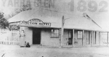
Black and white photographs, Junction Hotel, Yarra Glen
The Junction Hotel was built before 1875. It was located on the corner of the Yarra Glen-Eltham and Steels Creek Roads opposite the cemetery. The building was burnt down in August 1935. Samuel Smith was the licensee from 1895 until 1905Black and white photograph of the Junction Hotel, Yarra Glen copied from newspaper. The words "YARRA GLEN 1892" appear above the building. Sign on building "S.SMITH JUNCTION HOTEL LICENSED VICTUALLER". A woman wearing an ankle-length dress and boots is standing near main entrance. Weatherboard and iron roof, picket fence. Two bentwood chairs on brick-floored verandah. A light pole is attached to the verandah post. picket fence, nineteenth century, 19th century, hotel, bentwood chair, public house, sam smith, samuel smith, weatherboard, iron roof, tin roof, woman, junction hotel -
 Ringwood and District Historical Society
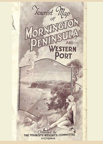
Memorabilia, Tourist Map of Mornington Peninsula and Western Port - 1929
Multi-fold pictorial map of towns, railways and main roads east of Port Phillip Bay from Melbourne to Yarra Junction and south to Phillip Island and Wonthaggi, backed by details of main features and points of interest.Photo-Lithographed by Department of Lands and Survey, Melbourne, 2.8.1929. -
 City of Moorabbin Historical Society (Operating the Box Cottage Museum)
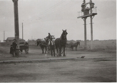
Photograph - Plateway (Wheelway) Steel, circa 1885
... Road, along Nepean road to its junction with Chapel Street, St... from Centre Dandenong Road, along Nepean road to its junction ...By the later 1800s the dirt roads in the then out-lying areas of the City of Moorabbin became dangerous, and almost impassable due to huge potholes and muddy swampy areas. The heavily laden market gardener’s carts regularly broke axles and wheels, and horses foundered on their way to the Melbourne markets. Even worse, the heavier “iron maidens”, carrying their malodorous loads of sewage from Melbourne’s inner suburbs for dumping in the outlying areas of the City of Moorabbin, also got bogged in the mire. It was decided that a practical solution to this problem was to install a metal plateway on the side of the problematic roads. In about 1887 the Moorabbin Shire Centre Road, in the Brighton East area, two parallel metal rails were installed so that the wheels of carts could run along smoothly, the horse travelled in the filled, middle area between the rails. Point Nepean Road plateway was removed in 1930 and Centre Dandenong Road plateway was removed in 1934-35. The worn plateway along Centre Road, East Brighton (now known as Bentleigh), was gradually taken up in several pieces, commencing in the the1920s, when its condition deteriorated and it caused a hazard to bikes, pedestrians, motor-cycles and the few early cars. The early steel plateway, constructed by David Munro, and opened on 23rd March 1885 by Thomas Bent, was built along Nepean Highway, between Asling St. and Bay St. The Point Nepean Track was subsequently extended into Moorabbin with branches along Centre, Cumins, South, Wickham, and Keys Roads, the total length was 13 miles. In 1908-1909 plates were laid along Centre Dandenong Road to Ross Street Bentleigh This innovative solution proved successful and was used until gradually the main roads were upgraded, and motorised vehicles started to appear. Two parallel metal rails were installed in the right hand side of a few main roads in the Shire of Moorabbin so that the wheels of heavily-loaded market gardener's carts on their way to markets in Melbourne could run along smoothly. The horse pulling the carts travelled in the filled, middle area between the rails. The Steel Plateway was constructed by David Munro, and opened on 23rd March 1885 by Thomas Bent. The wheelway first only ran along Nepean Highway, but it soon extended from Centre Dandenong Road, along Nepean road to its junction with Chapel Street, St Kilda. Later branch lines were built along Centre Road, Bentleigh as far as Warrigal Road and, according to early photographs, along Wickham Road Moorabbin as well. This innovative solution proved successful and was used until gradually the main roads were upgraded, and motorised vehicles started to appear. There was a problem with the wheelway : there was only a single set of rails and this was established on the right-hand side of the Nepean Road, travelling towards the city. Traffic FROM the city travelled on the correct or left-hand side of the road. The exception to this rule was the malodorous iron-clads, heavily riveted iron carts, generally travelling in convoy, carrying several tons of human effluent out of Melbourne to be trenched-in in the sandy soil of the Moorabbin district. Moorabbin City Council donated and installed a small section of Plateway at Box Cottage Museum in 1984melbourne, brighton, moorabbin, roads, plateway, wheelway, transport, st kilda, bent thomas, munro david, market gardens, steelway, carts horse-drawn, iron maidens, point nepean track -
 Bendigo Historical Society Inc.
Document - DON SHAFT - NOTES ON THE DON SHAFT
Hand written notes on the Don Shaft situated approximately 14 chains north of the junction of Specimen Hill and Marong Roads. Notes include dates and depth of shaft, shere x cuts were driven and gold returns.mine, gold, don shaft, don shaft, notes on the don shaft, gold returns -
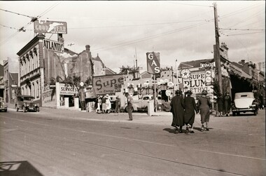 Ballaarat Mechanics' Institute (BMI Ballarat)
Centenary Main Road & Victoria St
... Road Victoria St 1938 Junction service station Centenary Main ...This photograph is from the Max Harris Collection held by the Ballaraat Mechanics' Institute. Please contact BMI for all print and usage inquiries.ballarat, centenary, main road, victoria st, 1938, junction service station