Showing 10914 items
matching lander
-
 Mont De Lancey
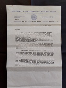
Document - Land Permit to Subdivide Land, Melbourne and Metropolitan Board of Works, 5th July 1974
Vintage legal documents for land division in Victoria, especially those predating the Torrens system (October 1862), are often found in the Public Record Office Victoria (PROV). These documents, like deeds and Crown grants, can help trace the history of land ownership and division. A letter from the Melbourne and Metropolitan Board of Works stating the application by Mr M. H. Proctor of Wandin dated 23rd April, 1974 for a permit to subdivide land in Wandin Yallock has been approved by the Board on 23 April, 1974. There are conditions required. The letter is signed: 'Yours faithfully, (O.T. W. Cosgriff) Assistant Secretary' for 'Mr. M. H. Proctor, Queens Road, Wandin, 3139. 'Board's Reference: Appln No, TP 76484'legal documents, contracts, documents, indentures -
 Federation University Historical Collection
1875
Land Purchase by James Cowan -
 Victorian Aboriginal Corporation for Languages
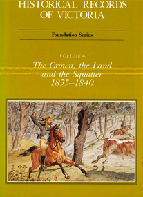
Book, Michael Cannon, Historical records of Victoria : foundation series : volume 6 : the crown, the land and the squatter 1835-1840, 1991
Reproductions of various transactions and reports dealing with squatting, land tenure and agricultural production in Port Phillip in the years 1835-1840. A history of land grants, surveying, squatters? life and land use during this period.maps, b&w illustrations, colour illustrationsvictorian history -
Whitehorse Historical Society Inc.
Article, Group Garden Turfed Out, 1992
The proposed Government sale of part of Nunawading Youth Residential Centre has forced one of Nunawading's Community Gardens out of its home.The proposed Government sale of part of Nunawading Youth Residential Centre has forced one of Nunawading's Community Gardens out of its home. The families involved are very upset, but the Council has no formal agreement with the Government over the use of the land.The proposed Government sale of part of Nunawading Youth Residential Centre has forced one of Nunawading's Community Gardens out of its home. community gardens, nunawading youth residential centre, community services victoria, nunawading community gardens -
 Ringwood and District Historical Society
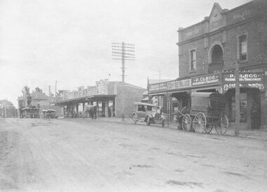
Photograph, Maroondah Highway Central, Ringwood. Coffee Palace and shops along Main Street between Adelaide Street and Melbourne Street. c1920's
Black and white photographWritten on back of photograph: "Land values - Main Street, Ringwood - land worth £50 pounds a foot." Image is taken from a land sale brochure and shows cars and horse drawn vehicles parked in front of buildings. -
 Linton and District Historical Society Inc
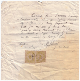
Receipt, Receipt for Payment for a Block of Land near Linton, 1918
Note that the block of land which was traded was not the block in Sussex Street, Linton on which the Sandows had a shop and house, but a block just outside the town boundary, near the Geelong Road (Linton-Naringhil Road). See map of Parish of Argyle for clarification.Photocopy of original handwritten receipt, which was for payment in full for a block of land situated just outside of Linton - Section A, Crown Allotment 1, Parish of Argyle. This land was purchased by Rubina (Ruby) Sandow from George Bolte in 1918. Receipt is for fifteen pounds, it is made out to "Rubinia Norwood Sandow" and is signed by Alf J. Smith, "for Geo. Bolte". Two Victorian Stamp Duty stamps are attached to the original document.rubina (ruby) sandow, george bolte, receipts, sale of land -
 Whitehorse Historical Society Inc.
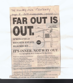
Article, Far out is out, 20/11/1994 12:00:00 AM
land sale on old Blackburn North Primary SchoolAdvertisement in Sunday Age for land sale on old Blackburn North Primary School land, appearing 20 November 1994. land sale on old Blackburn North Primary School land subdivision, springfield road, blackburn north, primrose street, blackburn north primary school -
Whitehorse Historical Society Inc.
Article, A win for all in give and take, 1990
Article about the conclusion reached through negotiation between land developers and residents of Vermont over subdivision of Wunderlich landArticle about the conclusion reached through negotiation between land developers and residents of Vermont over subdivision of Wunderlich landArticle about the conclusion reached through negotiation between land developers and residents of Vermont over subdivision of Wunderlich landrooks road vermont, mitcham road vermont, land subdivision, wunderlich limited -
City of Moorabbin Historical Society (Operating the Box Cottage Museum)
Document, leaflet Box Cottage Museum, Bambra Press Ltd, 2019
Reprint 2019 by Bambra Press Ltd; Original Print 2016 This Leaflet / Brochure was compiled by City of Moorabbin Historical Society members Carol Poole, Joan Moore, Fran Bader for distribution to visitors, schools, libraries and local community to promote knowledge of Box Cottage Museum and the early settlement in the Moorabbin area. Glen Eira City Council Community Grant 2016 was obtained to finance printing by MKR Printing Ltd. Carnegie. Topics Box Cottage Museum, City of Moorabbin Historical Society, 1918 Chinese silk wedding dress, contact details, map, Box Family, Rietman Family, Land tenure records, Henry Dendy Special Survey 1841Reprint 2019, Original print 2016 Leaflet/Brochure compiled by CMHS members for distribution to visitors, schools, local community to promote knowledge of Box Cottage Museum and early settlement in the Moorabbin area1 x A4 glossy, colour, printed on both sides with photographsPage 1 BOX COTTAGE MUSEUM Page 2 William & Elizabeth Box, Land, August Rietman & Familycity of moorabbin, brighton, dendy henry, box william, box elizabeth, rietman august, rietman frieda, box cottage museum ormond, box alonzo, glen eira city council, city of moorabbin historical society, ormond, bentleigh, cheltenham, bambra press ltd port melbourne, -
 Bacchus Marsh & District Historical Society
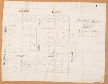
Map, Bacchus Marsh Estate sold 30th June 1888 and sold 28 December 1895
Blocks of land in this area of Bacchus Marsh were sold in lots between 1888 and the late 1890s. This map shows sales made in 1888 and 1895.Single page map showing allotments of land bounded by Pilmer Street, Graham Street, Sydney Street and Maddingley Road (Grant Street) in Bacchus Marsh.The area is dissected by Como Street down the central area. 43 blocks of land are shown with the names of buyers or sellers in 1888 written in black in. Buyers or sellers for December 1895 are written in red ink. Part of a set of maps which are pasted into a bound volume containing 76 maps or plans in total. High resolution digital image stored on BMDHS computer network. bacchus marsh victoria maps, land sales bacchus marsh, pilmer street bacchus marsh, graham street bacchus marsh, sydney street bacchus marsh, como street bacchus marsh, maddingley road bacchus marsh, grant street bacchus marsh -
 City of Kingston
Pamphlet - Colour, Roy Dunn Pty. Ltd, Central Corner Estate Moorabbin and Highett, c. 1923
Sales plan for land in the suburbs of Highett and Moorabbin, bordered by Point Nepean Road and Wickham Road East incorporating William StreetThe developing urban area of Highett and Moorabbin within the City of Kingston. This land sale pamphlet illustrates the subdivision of land within the municipality and the changing demographic of the district as new houses are constructed close to infrastructure.Colour pamphlet advertising for private sale land in the Central Corner Estate in Moorabbin and Highett. Incorporates a map of the estate bordered by Point Nepean Road and Wickham Road East, with subdivisions also available on both sides of William Street. Handwritten in blue pencil on subdivision plan: a tick is drawn on subdivisions 2-18 Handwritten in blue pencil on subdivision 6: a box with an x inside Handwritten in blue pencil on subdivisions 10 and 12: S Handwritten in black ink on front page: [indecipherable] / McKittricks Handwritten in grey pencil on rear page: McKilhick / Nepean Rd Handwritten in grey pencil on rear page upside down: 160000 / 15 8300 [crossed out] land sales, estate, highett, moorabbin -
 Bacchus Marsh & District Historical Society
Map, Plan of Land at Bacchus Marsh, the Property of James Young, 1868
James Young was a prominent businessman, land owner and public figure in the early colonial period of Bacchus Marsh. In February 1868 he offered for sale through the agent W. Anderson 38 blocks of land which ran from the Lerderderg RIver westwards beyond Gisborne Road in the vicinity of the present day Masons Land. The land for sale was described as, 'unsurpassed Agricultural Land, in the immediate vicinity of Bacchus Marsh, varying in size from 2 to 12 acres each'. The sale notice in the Bacchus Marsh Express of 1st February 1868 page 2, also noted that, ' Plans can be seen at Mr. Young's Border Mills Store, and at the Border Inn'. One of the largest and most important land sales in the early colonial period of Bacchus Marsh.A single page paper map showing 38 blocks of land for sale in 1868 in the vicinity of Masons Lane Bacchus Marsh. Scale 11 chains to 1 inch. The map is pasted into a bound volume containing 76 maps or plans in total. High resolution digital image stored on BMDHS computer network. land sales bacchus marsh, bacchus marsh victoria maps, james young 1816-1871, masons lane bacchus marsh land sales -
 Orbost & District Historical Society
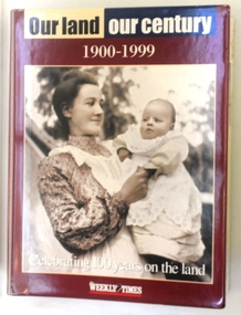
magazines in folder, Our Land Our Century 1900-1999, 1999
The Weekly Times was first published on September 11, 1869. In September 1875, The Weekly Times absorbed two other Melbourne-based rural publications, the Economist and Town and Country.In 1892 the Daily Telegraph company sold its buildings and mastheads to the Herald group, which has published The Weekly Times continuously since. In 1902 The Herald and Standard Newspaper Company Ltd changed its name to the present Herald and Weekly Times. These booklets were published as souvenir magazines to "celebrate 100 years on the land". They had ten parts published weekly from September 15 - November 17 1999. These magazines are records of 20th century rural history of Victoria. Ten magazines inside a hard plastic covered folder. They are Weekly Times souvenir booklets/magazines titled "Our Land, Our Century 1900-1999: Celebrating 100 Years on the Land". They contain pictures and stories of events related to rural Australia. Each edition covers ten years from 1900 -1989. -
 Bendigo Historical Society Inc.
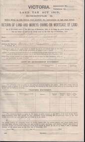
Document - KELLY AND ALLSOP COLLECTION: VICTORIA LAND TAX ACT 1910 - FORM, 31/12/1910 to 01/03/1911
Document. KELLY & ALLSOP COLLECTION. Three copies of Schedule B of Land Tax Act of Victoria 1910. 'Return of Land and Monies Owing on Mortgage of Land.' Each form partly filled out by Arthur Allsop in pencil, ie 'Particulars of Land' section. He owns two houses in Wills St and a vacant block of land at Pyke/Brodie Streets. Instructions to taxpayers 'Every owner of land must furnish a return before 1st March 1911 of all lands owned on 31 Dec 1910.'Taxation Office of Victoriabusiness, stockbroker, kelly & allsop, kelly & allsop collection, victoria land tax act 1910, schedule b -
 Bacchus Marsh & District Historical Society
Map, Bacchus Marsh Tuesday 23rd Oct. 1888, Lodge & Dunn's Paddocks 1888. Business and Mansion Sites
This map was created as a plan for an auction of land close to the Bacchus Marsh Railway Station. The auction took place on 23 October 1888. 102 allotments of land from an area known as Lodge and Dunn's paddocks was offered for sale. The auction was conducted by auctioneers based in Melbourne and was advertised in Melbourne newspapers as well as in the Bacchus Marsh Express newspaper. The auction plan contains a range of details including the selling agents, Munro and Baillieu; W.P. Lockhart; and John Turner, all of Melbourne, deposit terms for purchases, price of railway passes for a return trip from Melbourne to Bacchus Marsh of 1 shilling, and a description of the land as having 'magnificent views and perfect drainage'. A single page paper map showing allotments of land for sale along the Parwan Road in Maddingley. The map is pasted into a bound volume containing 76 maps or plans in total. High resolution digital image stored on BMDHS computer network. At bottom on left side: 'Harston & Co. Lith, Melb.'land sales bacchus marsh, land sales maddingley, bacchus marsh victoria maps, maddingley victoria maps -
National Vietnam Veterans Museum (NVVM)
Document, Extract from 17 Construction Sqn RAE Routine Orders: letter of thanks from the people of Tam Phuoc
The letter is from the people of Tam Phuoc expressing their thanks to the commanders & all drivers & crews of the 17th Const. Sqn Land Clearing Team & the 3rd Cav Det attached to the Land Clearing Team for clearing the land for their village.17th construction squadron, 3rd cavalry regiment, land mines -- tam phuoc -
 Surrey Hills Historical Society Collection
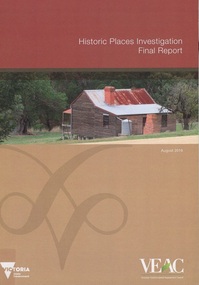
Book, Historic Places Investigation, Aug-16
In March 2014, the then Minister for Environment and Climate change requested the Victorian Environmental Assessment Council (VEAC) to undertake an investigation into historic places on public land across Victoria. This final report completes VEAC's investigation.In March 2014, the then Minister for Environment and Climate change requested the Victorian Environmental Assessment Council (VEAC) to undertake an investigation into historic places on public land across Victoria. This final report completes VEAC's investigation.historiic buildings - victoria, historic sites - victoria, public lands - victoria, veac -
Clunes Museum
Document - REPORT, HEPBURN SHIRE, 2024
PLANNING POLICY PRINCIPLES WILL BE TAILORED TO RESPOND TO LANDSCAPE VARIATION AND DRIVERS OF LAND USE CHANGE AND THE DIFFERENTIAL IMPACT THAT THESE HAVE ACROSS THE SHIRE....1 RURAL HEPBURN - AGRICULTURAL LAND STUDY AND RURAL SETTLEMENT STRATEGY, UNBOUND REPORT PRINTED IN COLOUR ON PAPER, 94 PAGES .2 FUTURE HEPBURN - CLUNES STRUCTURE PLAN, UNBOUND REPORT PRINTED IN COLOUR ON PAPER, 67 PAGES ADOPTED BY HEPBURN SHIRE COUNCIL 3 SEPTEMBER 2024hepburn shire council, rural settlement strategy -
 Bendigo Historical Society Inc.
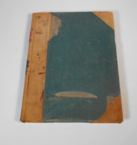
Administrative record - Application Register
The volume has green front and back cover. It has a leather spine with red and black labels. The pages in the volume are divided in columns: 1) Number of application, 2) Date of registry, 3) Date of application, 4) Surname, 5) Christian name and address, 6) Parish, 7) Allotment, 8) Section, 9) rea, 10) Local land board schedule, 11) Decision, 12) Special condition, 13) License, 14) References and remarks.On the spine red label with gold letters: Application register. A black label with gold letters: all other sections land act 1901. Also on the spine in red texter "Stock Lith."application register, land act 1901 -
 Whitehorse Historical Society Inc.
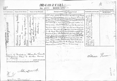
Legal record - Land Title, Land Memorial, 1860
Land Memorial No 963, Book 377, relating to transfer of land in Metropolitan Avenue, Nunawading from William Horan to William Loganhoran, william, logan, metropolitan avenue, nunawading, land sales -
 Whitehorse Historical Society Inc.
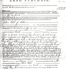
Legal record - Land Title, Land Purchase, 2/02/1858
Photocopy of agreement for land purchase by auction held on 2 February 1858.Photocopy of agreement for land purchase by auction held on 2 February 1858. Purchase by Nelson Polak of land adjacent to Dandenong Creek.Photocopy of agreement for land purchase by auction held on 2 February 1858. polak, nelson, dandenong creek, land sales -
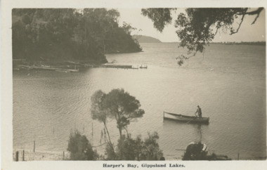 Lakes Entrance Historical Society
Postcard - Harpers Bay Gippsland Lakes, H D Bulmer, 1925 c
Harpers Bay showing the jetty where tourist launches moored for passengers to land and walk up to Mrs Westersons Cliffcrest Tea Rooms, Jemmys Point in distance Gippsland Lakes VictoriaBlack and white postcard of Harpers Bay showing the jetty where tourist launches moored for passengers to land and walk up to Mrs Westersons Cliffcrest Tea Rooms, Jemmys Point in distance Gippsland Lakes VictoriaHarpers Bay Gippsland Lakesbridges, islands, waterways, gippsland lakes -
 Lakes Entrance Historical Society
Photograph - John Kral, Lakes Post Newspaper, 1/03/1990 12:00:00 AM
John Kral competing in the A grade 250cc event at motor cycle meeting held at Campbells property Hoggs Land Lakes Entrance Victoria. Also black and white photograph taken during event at Motor Cross meet at Campbells showing one competitor airborne onlookers and vehicle parked beside track number 03950.1 size 7 x 12 cmBlack and white photograph of John Kral competing in the A grade 250cc event at motor cycle meeting held at Campbells property Hoggs Land Lakes Entrance Victoria people, sports, events, clubs -
Eltham District Historical Society Inc
Folder, J.D. and E. Cameron, 1850s
Cameron, Ewen Hugh, M.L.A.., J.P. Kangaroo Ground, is a native of Inverness-shire, Scotland, and came out to Victoria in the ship Hurricane, 13th September, 1853. After he had been engaged for two years int eh building trade in Melbourne in company with is two brothers, since dead, he carried on storekeeping for several years at the Caledonia gold diggings. In 1860 he purchased 80 acres of land at Kangaroo Ground, where he now resides, and later 160 aces of lands at Yarra Flats; he has also 600 acres rented, and is occupied in grazing and agricultural pursuits generally. Mr Cameron holds the prize given by the agricultural society for the best-kept farm in the district. In 1863 he was elected a member of the shire council, and has held the position to represent the Castlemaine mining board, which office he still holds, and in 1874, he was elected to a seat in the Legislative Assembly for the County of Evelyn, which seat he still retains, having the contested the constituency five times, and been elected once without opposition from "Victoria and its Metropolis: Past and Present" written in 1888 by Alexander Sutherland. Chapter 19, "The Upper Yarra District" pages [402] - 415. Includes descriptions of some townships and short biographies of local residents. Page 405 Folder of information on J D and E Cameron, land purchasers, Eltham, c.1850sj.d cameron -
 Bacchus Marsh & District Historical Society
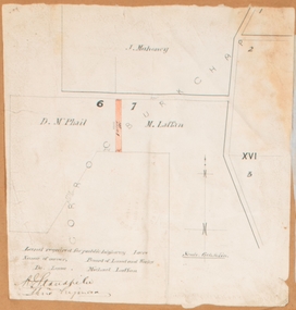
Map, Land required for a public highway near Rowsley, Victoria. Circa 1880s
This map indicates portions of land in the Parish of Gorrockburkchap near Rowsley which was required for construction of a road. The land required was leased to a Michael Laffan. Other blocks of land nearby owned or leased by D. McPhail and J. Mahoney are also indicated on the map. The date of the map is not known. However newspaper reports in the Bacchus Marsh Express on the 18 March 1882, page 3, column 3 mention land occupied by McPhail and Laffan near Rowsley in connection to the construction of a public road.Single page map showing land occupied by farmers D. McPhail and Michael Laffan which was required for a public highway. Scale 6 chains to inch. Part of a set of maps which are pasted into a bound volume containing 76 maps or plans in total. High resolution digital image stored on BMDHS computer network. Signed by Shire Engineer, W.E. Standfieldrowsley victoria maps -
 Kew Historical Society Inc
Plan - Framed Subdivision Plan (copy), F Price, Plan of Mr William Derrick's Land, Kew being Subdivision of Part of Section 86, Parish of Boroondara, County of Bourke, 1872, 1872
William Derrick was an early landowner in Kew, and with James Venn Morgan and James Dannock the purchaser of the parcel of land bounded by Cotham Road, High Street and Mary Street. Derrick Street in Kew is named after him.Map mounted under perspex. ‘Plan of Mr Willia Derrick's Land, Kew being Subdivision of Part of Section 86, Parish of Boroondara, County of Bourke’. This is a copy of the plan held in the State Library of Victoria.kew subdivision plan, john derrick, subdivision plans -- kew (vic.) -
Ringwood and District Historical Society
Agreements, Stillwell and Co, Contracts of sale of land in Ringwood 1911-1925 (Aird Orchard), 1911-1915
Details of contracts of sale of land in Ringwood between 1911 and 1915 executed by Mr Aird - subdivision of orchard between Adelaide Street and Andersons Creek Road (Warrandyte Road). In 1975, the house was the Presbyterian Manse. Orchard owned by J.G. Aird.12 contracts of sale of land in Ringwood between 1911-1915 executed by Mr Aird - buff coloured foolscap bifold documents with black printing and some handwritten. +Additional Keywords: Aird, J.G. -
 The Beechworth Burke Museum
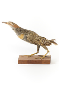
Animal specimen - Buff-Banded Rail, Trustees of the Australian Museum, 1860-1880
The Buff-banded Rail is located on mainland Australia. It can also be found in south-east Asia, New Guinea and New Zealand. These birds are often seen individually or in pairs walking through the dense reeds and vegetations of wetlands or crops. This rail has a slow walk and often flicks its tail, which is raised, as they move. They are omnivore scavengers who feed on a large variety of invertebrates, fruit, seeds and vegetables. This specimen is part of a collection of almost 200 animal specimens that were originally acquired as skins from various institutions across Australia, including the Australian Museum in Sydney and the National Museum of Victoria (known as Museums Victoria since 1983), as well as individuals such as amateur anthropologist Reynell Eveleigh Johns between 1860-1880. These skins were then mounted by members of the Burke Museum Committee and put-on display in the formal space of the Museum’s original exhibition hall where they continue to be on display. This display of taxidermy mounts initially served to instruct visitors to the Burke Museum of the natural world around them, today it serves as an insight into the collecting habits of the 19th century.This specimen is part of a significant and rare taxidermy mount collection in the Burke Museum. This collection is scientifically and culturally important for reminding us of how science continues to shape our understanding of the modern world. They demonstrate a capacity to hold evidence of how Australia’s fauna history existed in the past and are potentially important for future environmental research. This collection continues to be on display in the Museum and has become a key part to interpreting the collecting habits of the 19th century.This specimen is in a standing position with its neck stretched forwards on a wooden platform. The Buff-Branded Rail has a pale grey/yellow eyebrow over the orange glass eyes and a pale grey bill. It also has an orange and brown coloured band on its breast. This bird is multicoloured with streaks of chestnut brown, black, white and a faint orange-brown. This specimen has a paper identification tag tied to its left leg.20D. / Land Raid / See Catalogue, page, 35. /taxidermy mount, taxidermy, animalia, burke museum, beechworth, australian museum, skin, reynell eveleigh johns, bird, landrail, buff-banded rail -
 Ringwood and District Historical Society
Photograph, Maroondah Hwy near Oban Road, 28th January 1991, 1991
Digital photographLand developers wanted to make a commercial building but refused -
 Ringwood and District Historical Society
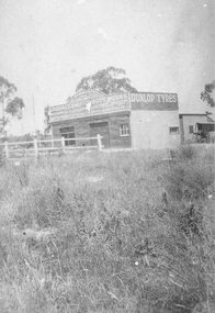
Photograph, Maroondah Highway West, Ringwood- c1920. F. Kenworthy, Ringwood. Garage and Motorbody Works
Black and white photograph (2 copies- 1 large, 1 small)Image shows Kenworthy building with vacant land opposite.