Showing 1120 items matching "orchard house"
-
 Glen Eira Historical Society
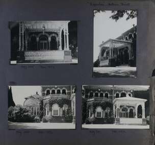
Album - Album page, Ripponlea, Hotham Street, Circa 1972
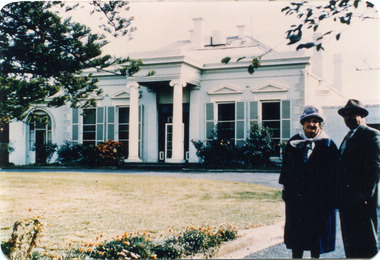
This photograph is part of the Caulfield Historical Album 1972. This album was created in approximately 1972 as part of a project by the Caulfield Historical Society to assist in identifying buildings worthy of preservation. The album is related to a Survey the Caulfield Historical Society developed in collaboration with the National Trust of Australia (Victoria) and Caulfield City Council to identify historic buildings within the City of Caulfield that warranted the protection of a National Trust Classification. Principal photographer thought to be Trevor Hart, member of Caulfield Historical Society. Most photographs were taken between 1966-1972 with a small number of photographs being older and from unknown sources. All photographs are black and white except where stated, with 386 photographs over 198 pages.From Victorian Heritage Database citation for Rippon Lea H0614 https://vhd.heritagecouncil.vic.gov.au/places/427(as at 23/10/2020) Rippon Lea was commenced in 1868 by Frederick Sargood, a most successful politician and merchant. He was born in England in 1834 and arrived in Melbourne in 1850. He soon joined his father's wholesale soft goods firm, spending some time as its manager on the goldfields. Sargood entered the Legislative Council in 1874. He was Victoria?s first Minister for Defence in 1883. Sir Frederick Sargood was created CMG. In 1885 and KCMG in 1890 as a reward for his contribution to public life. He died suddenly in 1903. Rippon Lea was designed by the leading firm of architects, Reed and Barnes. Joseph Reed had travelled in Europe in 1863, including northern Italy. When he returned he introduced the use of polychromy. While not the first examples, Rippon Lea and the Independent Church in Collins Street were the best and set a fashion which became a distinctly Melbourne style, particularly used for houses and churches. Its popularity was possible because of the new availability of different coloured bricks. Reed's fine Lombardic Romanesque details soon became debased by others. As Sargood's family grew and his fortunes prospered, Rippon Lea was extended to include 33 rooms - a complete mansion. The cast iron porte cochere and the northern conservatory were added in 1897. The architects were Taylor and Fitts. The ballroom was added in 1882 and remodelled in 1889. Many alterations have changed the interior and exterior during the ownerships of Benjamin Nathan and later his daughter Mrs Louisa Jones in the 1930s and are in their own right of significance. Sir Thomas Bent owned the property from 1903 until 1911 but never lived there. He subdivided much of the land. The original garden dates from about 1868, and it seems that William Guilfoyle of the Botanic Gardens was involved. It was redesigned in a more natural style in the 1880s by Sargood and his head gardener, Adam Anderson. The lake, waterfalls, fernery, hill and grotto are balanced by mighty deciduous trees and conifers. These are interspersed with, but never dominated by Australian species such as eucalyptus and other exotics. The sinuous drive with its carefully prepared approach to the house is notable. The original vegetable gardens, orchard and outer paddocks no longer survive. The shade house is important as the largest known in Australia and possibly the world. Its curved plan and form of construction are particularly notable. It was built about 1884.Page 92 of Photograph Album with four photographs (three landscape and one portrait) of Ripponlea - views of entrance and left front of mansion.Handwritten: "Ripponlea" Hotham Street [top right] / Neg 245 Dec 1972 [under top left photo] / Neg 246 Dec 1972 [under bottom left photo] / Neg 247 Dec 1972 [under bottom right photo] / 92 [bottom right]trevor hart, elsternwick, mansion, hotham street, frederick sargood, reed and barnes, lombardic, romanesque, cast iron porte cochere, conservatory, 1860's, 1890's, ballroom, 1880's, benjamin nathan, louisa jones, thomas bent, sir thomas bent, william guilfoyle, adam anderson, lake, grotto, shade house, portico, ripponlea, victorian, sir frederick sargood, architects, polychrome bricks, lombardic romanesque style, rippon lea, entrances -
 Glen Eira Historical Society
Album - Album page, Ripponlea, Hotham Street, Circa 1972
This photograph is part of the Caulfield Historical Album 1972. This album was created in approximately 1972 as part of a project by the Caulfield Historical Society to assist in identifying buildings worthy of preservation. The album is related to a Survey the Caulfield Historical Society developed in collaboration with the National Trust of Australia (Victoria) and Caulfield City Council to identify historic buildings within the City of Caulfield that warranted the protection of a National Trust Classification. Principal photographer thought to be Trevor Hart, member of Caulfield Historical Society. Most photographs were taken between 1966-1972 with a small number of photographs being older and from unknown sources. All photographs are black and white except where stated, with 386 photographs over 198 pages.From Victorian Heritage Database citation for Rippon Lea H0614 https://vhd.heritagecouncil.vic.gov.au/places/427(as at 23/10/2020) Rippon Lea was commenced in 1868 by Frederick Sargood, a most successful politician and merchant. He was born in England in 1834 and arrived in Melbourne in 1850. He soon joined his father's wholesale soft goods firm, spending some time as its manager on the goldfields. Sargood entered the Legislative Council in 1874. He was Victoria?s first Minister for Defence in 1883. Sir Frederick Sargood was created CMG. In 1885 and KCMG in 1890 as a reward for his contribution to public life. He died suddenly in 1903. Rippon Lea was designed by the leading firm of architects, Reed and Barnes. Joseph Reed had travelled in Europe in 1863, including northern Italy. When he returned he introduced the use of polychromy. While not the first examples, Rippon Lea and the Independent Church in Collins Street were the best and set a fashion which became a distinctly Melbourne style, particularly used for houses and churches. Its popularity was possible because of the new availability of different coloured bricks. Reed's fine Lombardic Romanesque details soon became debased by others. As Sargood's family grew and his fortunes prospered, Rippon Lea was extended to include 33 rooms - a complete mansion. The cast iron porte cochere and the northern conservatory were added in 1897. The architects were Taylor and Fitts. The ballroom was added in 1882 and remodelled in 1889. Many alterations have changed the interior and exterior during the ownerships of Benjamin Nathan and later his daughter Mrs Louisa Jones in the 1930s and are in their own right of significance. Sir Thomas Bent owned the property from 1903 until 1911 but never lived there. He subdivided much of the land. The original garden dates from about 1868, and it seems that William Guilfoyle of the Botanic Gardens was involved. It was redesigned in a more natural style in the 1880s by Sargood and his head gardener, Adam Anderson. The lake, waterfalls, fernery, hill and grotto are balanced by mighty deciduous trees and conifers. These are interspersed with, but never dominated by Australian species such as eucalyptus and other exotics. The sinuous drive with its carefully prepared approach to the house is notable. The original vegetable gardens, orchard and outer paddocks no longer survive. The shade house is important as the largest known in Australia and possibly the world. Its curved plan and form of construction are particularly notable. It was built about 1884.Page 93 of Photograph Album with four photographs (two landscape and two portrait) of Ripponlea - lake and gardens.Handwritten: Neg 239 Dec 1973 LAKE [under top left photo] / Neg 242 Dec 1973 FERN HOUSE [under top right photo] / Neg 243 Dec 1972 FERN HOUSE [under bottom left photo] / Neg 241 Dec 1972 LAKE [under bottom right photo] / 93 [bottom left]trevor hart, elsternwick, mansion, hotham street, frederick sargood, sargood, reed and barnes, 1860's, 1890's, 1880's, benjamin nathan, nathan, louisa jones, thomas bent, sir thomas bent, william guilfoyle, adam anderson, lake, grotto, shade house, portico, ripponlea, victorian, sir frederick sargood, architects, taylor and fitts, rippon lea, gardens, ferns, bridges, walking trails -
 Federation University Historical Collection
Photograph - Photograph and Documents, Anne Beggs Sunter, Latta/Downing Family, Mount Helen
The Federation University Mt Helen Campus was once the farm of John Latta and his wife Elizabeth Ann Dean. The couple married in 1867 and had three children at the time of John Latta's death (Elizabeth Ann b.1870; Mary b.1873; John b.1875). Elizabeth later married George Downing, and had another six children. The house was situated in the vicinity of the current Administration and Caro Conference Centre buildings, surrounded by an orchard, and a well under the current Albert Coates Building (Union Building). The land was purchased by the Ballarat School of Mines for their tertiary division from the Stapleton family.Various items relating to the Federation University Mount Helen Campus, and the early settlers on the land, the Latta Family. .1) Parish Plan, including E. Latta, M. Fiscalini, R. Wynne, R. Nixon, J.U. Smith, J. Davis .2) Part of a 1930s ordinance map showing Ballarat, Buninyong and Greenhill .3) Contour Map with the first two Mt Helen Campus buildings included. .4) Drawing a a proposed campus plan .5) Latta Family negativemount helen campus, latta family, greenhill, e. latta, m. fiscalini, r. wynne, r. nixon, j.u. smith, j. davis, parish plan, john latta, elizabeth latta, george downing, elezabeth downing, green hill, pontresina, abraham baxter, g. dean, market gardens, jim downing, bob thornton, j. hateley, martin fanning, toll keeper, anne beggs sunter -
 Ringwood and District Historical Society
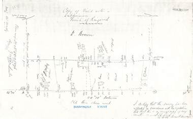
Document - Copy of Lands Department Field Notes - Parish of Ringwood, Victoria, Field Notes 88-9/276 - Part of O.P. R72C surveyed 12.10.1888
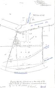
Foolscap size photocopy of survey map with handwritten notations. References include - Commencing at bank of creek, Bearing over fence read 134"12', post and rail fence, old round post, Quigley, WB house iron roof, paling & shingle roof, garden, Forshaw formerly Hoare, D Brown, stable & shed, slats & palings, orchard, Occupied by Forshaw, 4 rooms WB Cottage iron roof, Sherbin, Old three chain road, Maroondah Highway, Molloy's corner, I certify that this survey has been effected in accordance with the regulations and that this is a correct copy of my results (signed) - Reed, Assistant Surveyor, 12.10.88. -
 Ringwood and District Historical Society
Document - Copy of Lands Department Field Notes - Parish of Ringwood, Victoria, Field Notes 1909/174 - Part of O.P. R72D surveyed 12.3.1909
Foolscap size photocopy of survey map with handwritten notations. References include Mount Dandenong Road, pathway, 2 room house, scillion, shed, WC, 17C sold, Cr lands, orchard, 17E sold, Township boundary, I certify that these field notes are a true copy of the actual results of observations and measurements taken by me on the ground (signed) D. Barker 12.3.09. -
 Ringwood and District Historical Society
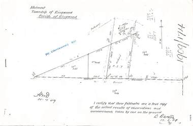
Document - Copy of Lands Department Field Notes - Parish of Ringwood, Victoria, Field Notes - OP34838 - surveyed in 1919 by D. Barker
5615b Foolscap size photocopy of survey map with handwritten notations. References include Braeside Avenue, Mount Dandenong Road, Rosedale Court, Railway Avenue, cyclone fence, Sec A, WB house, old tennis court netted, stable, old shed, tank stand, orchard, Township Boundary, netting fence, Railway fence, Ringwood to Lilydale Railway, I certify that these fieldnotes are a true copy of the actual results of observations & measurements taken by me on the ground (signed) D. Barker (1919). -
 Ringwood and District Historical Society
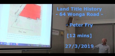
Mixed media - Video, RDHS Guest Speaker Presentation - "Land Title History, 64 Wonga Road, Ringwood" - Peter Fry
Digitised video (662MB). Duration: 12 minutes. Recorded March, 2019. (Video is available for viewing at Ringwood & District Historical Society Archives by appointment)Presentation: Peter Fry has done quite a bit of tracing of properties in the Ringwood area where he grew up. In this talk, Peter presents an example of his research, covering the house and property now known as 64 Wonga Road, which has a long and interesting history dating back to the early days of orcharding in the district. -
 City of Moorabbin Historical Society (Operating the Box Cottage Museum)
Equipment - Dairy Equipment, cheese cutter
This cheese cutter was made and used by an early settler family in Moorabbin Shire c 1900Early settler families in Moorabbin Shire were self sufficient making their own tools , kitchen equipment, and clothing while they established market gardens, dairy farms , poultry farms, orchards and flower nurseries. Each family had a 'house cow ' to provide dairy products of milk, cheese, cream and butter.A wooden frame with wire cross pattern for cutting cheesecheese cutter, equipment, box cottage, dairy -
 City of Moorabbin Historical Society (Operating the Box Cottage Museum)
Photograph - Photograph, Black & White Mrs J.L.Smith & Butcher, 1915
The Butcher Mr Bill Ellin delivering meat to Mrs J.L.Smith in front of the house Law Muir Den 510 Centre Rd Bentleigh c 1915. Groceries, Ice, Milk, Bread, Eggs, Poultry were delivered to housewives by the traders in horse drawn carts, Also Hawkers and Pedlars plied their wares by visiting the cottages. John Logan Smith 1860-1932 , the son of Irish immigrants James and Marianne Smith was born at their home near the 'Toll Gates' on Point Nepean Road and Dendy Street. East Brighton. At that time the area had many orchards that were later replaced by market gardens. J.L.Smith at first rented a cottage 'Law Muir Den' & Shed from Mr Box and commenced business as a wood merchant - sawing logs into shorter pieces using one horse to power the saw. He purchased the property, added to the buildings , began trading in fuel and fodder as well and installed a chaff cutting mill powered by 10hp steam engine. The business prospered 1909 following the death of Tommy Bent, J/L Smith was nominated for Councillor of the Shire of Moorabbin. WW1 1914 - 18 both John and Mary Ann supported local War Relief Auxiliaries and their son Vic served as a Signaler in AIF. As Motor transport was increasing 1926 J L Smith built a small Garage on the opposite corner (Woolworths Supermarket 2005) , employed a good mechanic ( Reg Hunt ) and developed another successful business. The Grain Store was managed by family until 1930. In 1932 JL Smith assisted a man whose car had broken down, pushing it to the garage and sadly suffered a heart attack and died. He is buried in Cheltenham Cemetery. J.L.Smith was an early settler in East Brighton now Bentleigh and established successful Wood cutting, Grain & Chaff cutting and Motor garage businesses in Centre Road . He was elected Councillor of the Shire of Moorabbin and, with Mary Ann, his family were involved with local Church, Red Cross, and other community organizations.A Black and white photograph c 1915 showing the Butcher delivering meat to Mrs J.L Smith Bentleighsmith j l, smith mary ann, stanley helen, smith vic, smith harry redvers, chaff cutter, horse drawn carts, toll gates brighton, motor cars 1900, steam engines, early settlers, bentleigh, parish of moorabbin, city of moorabbin, county of bourke, moorabbin roads board, shire of moorabbin, henry dendy's special survey 1841, bent thomas, charman s, highett william, ormond francis, market gardeners, vineyards, orchards, william ellin, butcher -
 City of Moorabbin Historical Society (Operating the Box Cottage Museum)
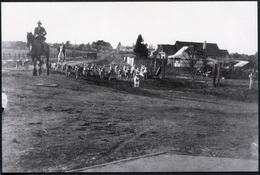
Photograph, Black & White Oakleigh Hunt Club in Jasper Rd c 1920, c1920
The Melbourne Hunt Club was founded by Mr George Watson in 1852 with hounds brought to Australia from Ireland and moved its headquarters a number of times as the city grew between 1897 and 1929, The kennels were originally at Kirk's Bazaar, in Bourke Street, Melbourne, subsequently they moved to St Kilda, Caulfield, Deer Park, Oakleigh, Cranbourne and finally to their current location in Packenham. Oakleigh was the favoured spot, mainly because of the railway and the unloading ramp at the station. Riders and horses arrived on special trains and hunted over the surrounding market gardens, but not without friction. After 1929, significant numbers of Hunt Club members had access to motorized horse transport and besides, Oakleigh was becoming too built up. The Hunt Club moved on to Cranbourne The club maintains the oldest continual pack of hounds in Australia. The Melbourne Hunt Club was founded 1852 by George Watson and imported foxhounds from Ireland. As the Melbourne suburbs spread the Club moved several times. 1920 it was in Oakleigh and now is possibly situated in Packenham Black & White photograph showing men riding horses with a pack of hounds coming down a dirt road . Houses and vacant land in backgroundwatson george, oakleigh, melbourne hunt club, smith j l; smith mary ann, stanley helen, smith vic, smith harry redvers, chaff cutter, horse drawn carts, toll gates brighton, motor cars 1900, steam engines, early settlers, bentleigh, parish of moorabbin, city of moorabbin, county of bourke, moorabbin shire, king richard, charman s, highett william, ormond francis, maynard dennis, market gardeners, vineyards, orchards -
 City of Moorabbin Historical Society (Operating the Box Cottage Museum)
Photographs,x3 Colour Early Weatherboard Cottage Cheltenham c1880, 1981
Henry Dendy , a farmer from Sussex England, purchased 5,120 acres of land in the area of a 'Special Survey 1841' that extended from Brighton bayside North Road, East Boundary Rd to South Road. This area became known as Dendy's Brighton and as part of the sale 139 emigrant workers arrived in 1842 however Dendy was unable to find work and lodgings for these people. J.B.Were, financier took over the management of the 'Special Survey 1841' area and began to sell and lease allotments. 1850 the Squatter King brothers sold land south of Dendy's 'Special Survey 1841' to Josiah Holloway who sectioned it into 2 acre lots @ £10 each for market gardens - 'Two Acre Village' and Charles Whorral opened a small hotel - 'The Cheltenham Inn' on the main Road - Arthur's Seat Rd, later Point Nepean Rd, now Nepean Highway. Notable settlers who moved into the area were Keys, Charman, Bruton, Le Page, Fairlam, Meeres and 1862 saw the separation from Brighton and the formation of the Mooorabbin Roads Board District. .By 1879 1000settlers were living in 'Cheltenham' serviced by a Post Office with Bank, Mechanics Institute, State School No 84,Keys Hotel, Meeres Store, Sir Thomas Bent ensured the new Railway Line from Caulfield to Mordialloc went through his constituency of Cheltenham 1881 and this changed the development to the bayside area of Cheltenham away from the 'Two Acre Village ' side causing some dissention, However Cheltenham as whole prospered and this house in Pine St is typical of the cottages built c 1890- 1900 in the area. This weatherboard house c 1890-1900 in Pine St Cheltenham is typical of those built for early settler families. Photo taken 1981 by CMHS member 3 x Colour photographs of an early c 1900 weatherboard house in Pine St Cheltenham taken by CMHS member 1981Kodak Aug. 81 / Handwritten Pine St Cheltenhamkeys robert, holloway josiah, king brothers, smith j l; smith mary ann, stanley helen, chaff cutter, horse drawn carts, toll gates brighton, motor cars 1900, steam engines, early settlers, bentleigh, parish of moorabbin, city of moorabbin, county of bourke, moorabbin roads board, shire of moorabbin, henry dendy's special survey 1841, were j.b.; bent thomas, o'shannassy john, king richard, charman stephen, highett william, ormond francis, maynard dennis, market gardeners, vineyards, orchards -
 City of Moorabbin Historical Society (Operating the Box Cottage Museum)
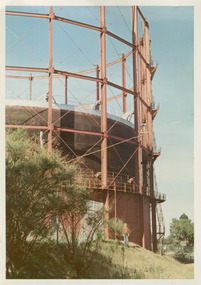
Photographs, x3 Colour,, Highett Gasworks c1974, 1974
3 of 5 photographs of the Highett Gasworks c 1974 The Brighton Gas Company was established 1877 by local residents including Thomas Bent. Initially all went well for residents as gas light replaced kerosene lamps and street lights were installed. However disruption to supply, poor quality and failure to reach all house lead to dissatisfaction. Thomas Bent therefore began the Central Brighton and Moorabbin Gas Company 1885 and a price war ensued. This was unsustainable and the two companies amalgamated in 1877 supplying gas from the New Street Works site. 1930 this Company expanded to Highett where it had purchased 45 acres adjacent to the train line. 1927 a gas holder was built connected to the Brighton works 1936 construction began on a complete gas-making unit and the Highett Gasworks, Nepean Highway, began supply 1939. 1950 an extension program was completed. However by 1965 , with the discovery of Natural Gas offshore in Bass Strait, changes to Gas distribution were apparent. At first some of the facilities at Highett were used to distribute the gas piped from Sale, Gippsland. However after conversion of 450,000 homes to Natural Gas the Highett site was redundant. The gasometers were removed 1978. Moorabbin Council obtained part of the land for public recreation purposes. ( Dr. G Whitehead KCC Historian ) c2012 the Moorabbin Justice Centre / Magistrates Court of Victoria was built and further development of the area for apartments proceeds. The establishment of the Brighton Gas Company 1877 and the Highett Gasworks 1885 brought bright lighting to houses, businesses and streets in Moorabbin Shire and cooking ovens and heating improved the living conditions of residents. 3 x Colour photographs of the Highett Gasworks c1970bass strait gas, highett gasworks, brighton gasworks 1877, central brighton and moorabbin gas company 1885, whitehead dr. graham, magistrates court of victoria, horse drawn carts, toll gates brighton, motor cars 1900, steam engines, early settlers, bentleigh, parish of moorabbin, city of moorabbin, county of bourke, moorabbin roads board, shire of moorabbin, henry dendy's special survey 1841, were j.b.; bent thomas, o'shannassy john, king richard, charman stephen, highett william, ormond francis, maynard dennis, market gardeners, vineyards, orchards -
 City of Moorabbin Historical Society (Operating the Box Cottage Museum)
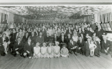
Photograph , Black & White Opening McKinnon Progress Hall c 1925, c1925
McKinnon was a small community in East Brighton settled mainly by market gardeners but it had a State School, Churches, a hotel opened by Thomas Bent's father, Post Office and some shops. After WW1 land close to the railway line began to be sold and new homes and various shops were built. A Progress League was well supported and new hall built. McKinnon Rd Shopping precinct did not prosper as expected and some attribute this to the failure to secure the Hoyts picture theatre c 1925. Hoyts instead built the theatre in Centre Rd Bentleigh and this took a lot of trade away from the shops in McKinnon Rd.McKinnon was settled by market gardeners and after the train line arrived more houses and shops were built so that the small community developed through the 20thCBlack & White photograph showing the crowd of local residents celebrating the opening of the McKinnon Progress hall c1925mckinnon progress league, mckinnon railway station, ormond state school, hoyts picture theatres, centre road bentleigh, wyles jim, mckinnon hotel, gardeners arms hotel, bent james, smith j l; smith , chaff cutter, horse drawn carts, toll gates brighton, motor cars 1900, steam engines, early settlers, bentleigh, mckinnon, parish of moorabbin, city of moorabbin, county of bourke, moorabbin roads board, shire of moorabbin, henry dendy's special survey 1841, were j.b.; bent thomas, o'shannassy john, king richard, charman stephen, highett william, ormond francis, maynard dennis, market gardeners, vineyards, orchards -
 City of Moorabbin Historical Society (Operating the Box Cottage Museum)
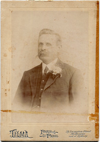
Photograph, Black & White, Harry Hale 1861-1937 and House, Cheltenham c1900, c1900
Harry Hale 1861-1937, a silk spinner, builder, migrated from England c1890 and built his house using 2nd hand material from the old Mentone Baths, old Co-op Stores, and some windows from the old St Matthew's Church Cheltenham .Harry with wife Frances raised 9 children. Following an accident Harry lost his leg and dissatisfied with the artificial limb he found a 'peg- leg ' more comfortable. Harry built many houses in Cheltenham unhindered by his 'peg-leg' . Harry also worked as an Insurance Agent. \ The house was demolished 1962. ( T. Sheehy, Moorabbin News 1962 H. Stanley )Harry Hale was a typical resourceful early settler who courageously worked with disability as he established his family in Cheltenham c1900a) Black & White photograph of the Harry Hale's House c 1930 North Cheltenham b) Sepia photograph c1906 of Harry Hale 1861 - 1937, Builder, Insurance Agent Cheltenham a) Handwritten information b) Mount ; TALMA, PARIS PANEL , 119 Swanston Street Melbourne and at Sydney hale harry, st matthews church of england cheltenham, talma photographers melbourne, photography, horse drawn carts, toll gates brighton, motor cars 1900, steam engines, early settlers, bentleigh, mckinnon, parish of moorabbin, city of moorabbin, county of bourke, moorabbin roads board, shire of moorabbin, henry dendy's special survey 1841, were j.b.; bent thomas, o'shannassy john, king richard, charman stephen, highett william, ormond francis, maynard dennis, market gardeners, vineyards, orchards -
 City of Moorabbin Historical Society (Operating the Box Cottage Museum)
Photograph, Black & White, 'Oak Bank' later 'Whitehouse' Ann St. McKinnon c1920, c1960
'Oak Bank ' , in Ann Street McKinnon, was originally owned by Mr Robert Smith. The house was later renamed 'The Whitehouse' and was still in use as a General Hospital in the 1950's, known as the Ann Street Hospital.. This small hospital handled some Surgery, Midwifery and general Medical cases from the fast growing Bentleigh / McKinnon area. As time progressed the Hospital became too small, and was unable to meet new medical standards When Moorabbin Community Hospital opened c1974 in Centre Road East Bentleigh, the Ann St Hospital closed. The Moorabbin Hospital is now a campus of Monash Medical Centre Clayton. 'The Whitehouse' was used as a general Hospital for the residents of McKinnon, Bentleigh, and Ormond for many years during the 20thC.Colour photograph showing Mrs John Marriott ( nee Ann Smith) , her son Fred Marriott standing outside 'The Whitehouse' undated ? c1960Back ; Handwritten informationoakbank house mckinnon, whitehouse mckinnon, ann street general hospital, moorabbin community hospital, monash hospital clayton, smith robert, lees seedling growers ltd. thomas street mckinnon,mith j l; smith mary ann, stanley helen, smith vic, chaff cutter, horse drawn carts, toll gates brighton, motor cars 1900, steam engines, early settlers, bentleigh, mckinnon, parish of moorabbin, city of moorabbin, county of bourke, moorabbin roads board, shire of moorabbin, henry dendy's special survey 1841, were j.b.; bent thomas, o'shannassy john, king richard, charman stephen, highett william, ormond francis, maynard dennis, market gardeners, vineyards, orchards -
 City of Moorabbin Historical Society (Operating the Box Cottage Museum)
Photograph - 115 Jasper Road, Bentleigh, Allan / Grewer Estate, c. 1890's
115 Jasper Road, Bentleigh East was a market garden owned by James Allan. In 1880 the property was transferred to David Grewar (Gruar) who had married James' niece Mary Allan. In 1926 part of the land was subdivided and sold as residential blocks. The block with the house pictured remained in the family until 1969. The land now forms part of Our Lady of Sacred Heart College. The description of the land owned by David Kidd Grewer (also spelt Gruar) in 1885: Fourteen acres or thereabouts at the corner of Jasper Road and Patterson’s Road East Brighton being part of Crown Block of 5720 acres Parish of Moorabbin County of Bourke being land comprised in Certificate of Title Volume 1344 Folio 268692 on which is erected a 4 roomed brick house with 2 rooms of wood at the rear and stable and a 2 roomed weatherboard cottage valued as under: 14 acres of land less crops £629.0.0 4 roomed brick house £250.0.0 Other buildings £50.0.0 2 roomed weatherboard cottage £35.0.0 Early pioneer family of the City of Moorabbin.Black and White photo in picture framegrewar, market garden, moorabbin, bentleigh, jasper road, housing, pioneer, james allan, orchard -
 Bendigo Historical Society Inc.
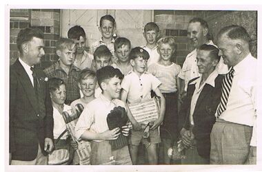
Photograph - PRESENTATION OF CRICKET EQUIPMENT TO PRIMARY SCHOOL BY SANDHURST CRICKET CLUB
group photo of 11 school boys with four men, standing outside brick building, wooden door behind group. Boys in front are holding cricket pads and gloves. Written on back : 'back: Neil Button, John Turner, Maurice Grose, Centre: Lance Orchard, Graeme Moore, Merv Miles, Les Rodda, F. Stave Wallace, Ken Hartley, Paul Gill, Trevor Phillips, Bill McConnell, Noel Turner Walshy !. Presentation of cricket equipment to school by Sandhurst Cricket Club, 1951 ? On bottom LH side : V. Phillips, 274 (?9) Eaglehawk Rd. Eaglehawk.bendigo, sporting clubs, sandhurst cricket club, cricket, sandhurst, school, presentation -
 Bendigo Historical Society Inc.
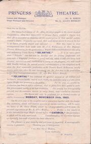
Document - EVA MAY CROWTHER COLLECTION: PRINCESS THEATRE PROGRAMME
Programme for comic opera ''Iolanthe'' commencing November 24th, 1902 at the Princess Theatre. Main actors: Mr. Alex Hamilton, Mr. S. Horwood, Mr. W. Cahill, Mr. E. Allen Bindley, Mr. R. Eddy, Mr. Tom Pritchard, Miss Beatrice English, Miss Eva Crowther, Miss Rose O'Mahoney, Miss Addie Campbell, Miss Else Crowther, Miss Rose Spargo, Miss Lillian Orchard and Miss Florence Quinn.program, theatre, princess theatre bendigo -
 Bendigo Historical Society Inc.
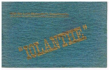
Document - THEATRE PROGRAMME - IOLANTHE
Teal coloured, textured fold out programme, Iolanthe or The Peer and the Peri at the Royal Princess Theatre, Bendigo. With the Lord Chancellor's Compliments and 'Iolanthe' printed in gold on the front. The red printing is on cream silk. It contains the names of the actors and production workers.entertainment, theatre, programme, theatre programme, iolanthe, alex j hamilton, stan horwood, w cahill, e allen bindley, roy eddy, t pritchard, miss eva crowther, miss addie campbell, miss r o'mahoney, mill lillian orchard, miss rose spargo, miss addie keating, miss florence quinn, m b sluyterman, g coulter, coulter & smith, mesdames wisby, trant, j coates, m hamburger, o g c flight, a g finster, reed & co. -
 Bendigo Historical Society Inc.
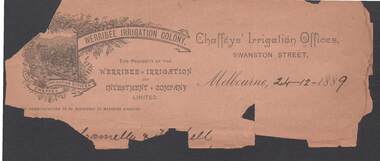
Document - CONNELLY, TATCHELL, DUNLOP COLLECTION: FRAGMENT OF INVOICE WERRIBBEE IRRIGATION COLONY
Invoice from Werribee Irrigation Colony, Chaffeys' Irrigation Offices, Swanston Street, Melbourne 24.12.1889. Bottom section is missing with details of transaction. Invoice has image of orchard, image surrounded by grapevines. Fragile condition.business, legal, chafffeys' irrigation offices, connelly, tatchell & dunlop, irrigation, mildura, werribee, industry -
 Bendigo Historical Society Inc.
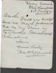
Postcard - COHN BROTHERS COLLECTION: 1894 POST OFFICE LETTERCARD
Post Office lettercard with Glenthompson P O receival hand stamp dated June 18th 1894 with 574 barred cancellation over One Penny stamp addressed to The Secretary Cohns Bros Victoria Brewing Co, 487 Collins Street, Melbourne. Reverse handwritten note from Miss H. FitzGerald 'Cherry Orchard' Glenthompson requesting that Cohns Bros send her dividend cheque.bendigo, industry, cohn bros brewery -
 Bendigo Historical Society Inc.
Document - SEDGWICK INFORMATION
Document, Sedgwick, was known as Upper Emu Creek until 1901. It is located ten miles south of Bendigo in hilly sedimentary and granite country.The first freehold grants were taken up in 1854. In 1861 the Strathfieldsaye Road District was Proclaimed. Five years later it became the Shire of Strayhfieldsaye.Mining west of the Axe Creek commenced in 1863. Agriculture, farmers made modest livings from vineyards, orchards,dairy cattle, eggs and tomatoes. The Osborne family had seventy acres planted to apples. Prior to 1934 Favaloros collected cream from district farms, then fresh milk in cans was carted to Bendigo until 1970.document, sedgwick -
 Bendigo Historical Society Inc.
Document - PAPER ON: ''THE GROWTH OF METHODISM DURING 1850'S - 1890'S' ON THE (BENDIGO) GOLDFIELDS''
Fourteen paged Paper on ''The Growth of Methodism during 1850's - 1890's' on the (Bendigo) Goldfields'' by Lyn Barnes, Bendigo Tech College student 1980. While the Specific Interest Area is highlighted on page 1 as ''Mackenzie Street Church'' the paper covers a variety of topics - General comments about Methodism during the Gold Era (approx 2 pages); The Cornish Contribution (approx, 1 page); A Cornish man of particular note - James (Jimmy) Jeffrey (approx. 1 page); The Sandhurst Circuit (approx. 3 pages); Sandhurst Chinese Mission (approx. 1/2 page); Mackenzie Street Church (approx. 2 pages); Extract from letter from Rev William Butters to Rev W B Boyce, London (approx. 1 page); portraits of four Methodist Pioneers (1 page); ''Statistical Pages (1 page); Reference List (1 page).church, history, methodist, george eisfelder. rev john orchard, golden square wesleyan church, bible christian church long gully, rev w h hoskens, miss beryle buley. mr graydon grey. rev. william butters. mr walter powell. "california" taylor. -
 Bendigo Historical Society Inc.
Document - HISTORY OF MACKENZIE STREET METHODIST CHURCH 1866 TO 1966
Detailed 56 paged history of Mackenzie Street Methodist Church 1866 - 1966 by George Eisfelder. Composed of church records and various Resolutions of the church committee.George Eisfelderchurch, history, mackenzie street methodist church, george eisfelder. rev john orchard, golden square wesleyan church, bible christian church long gully, rev w h hoskens, miss beryle buley. mr graydon grey. -
 Mount Evelyn History Group
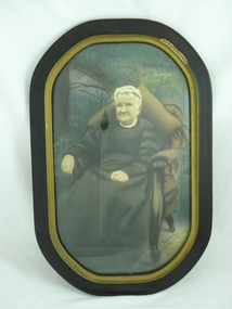
Photo (framed) L Morrison, Seated portrait of Mrs Louisa Morrison nee Haag (?), c. 1940
... ' Orchard in Old Hereford Road, Mt Evelyn. The Morrison home ...This item was donated as a photograph of Louisa Morrison. Louisa (or Luisa) Rosanna Morrison nee Haag came from an early settler family in the farming community of Wandin. The woman photographed is in her old age. If this is indeed Louisa Morrison, the photograph would date from the early 1940s, since she died in 1946 at the age of 70. However the costume and the style of the photo suggest an earlier date, possibly the early 1900s. This could be Louisa's mother, Emma Martha Haynes, or mother-in-law Margaret (McNeil) Morrison. The woman is shown in a garden, probably because the family were farmers/orchardists. Louisa married Daniel McNeil Morrison, who was nine years her senior , in 1900. They had four children and farmed Morrisons' Orchard in Old Hereford Road, Mt Evelyn. The Morrison home was to become the important community house in Mt Evelyn, Morrison House. Morrison Reserve is part of their land, as was Yarra Hills Secondary College, Mt Evelyn Special Developmental School and the Reserve and Athletics facilities, including a tennis club. In 1981 the land title was changed to the Shire of Lillydale, who purchased the land and established the Morrison House Community House from 1976 (ie before they legally owned the land).This picture is of social significance as it is the only reputed picture of Louisa Morrison nee Haag.Brown round cornered frame with gold colour on inner frame. Painted plaster on frame chipped on top right. Coloured (painted) photograph of seated woman in upholstered chair with large brown cushion behind her. Garden setting. Black floor length dress, high necked, long sleeved. White cap on head. White cloth showing at neck.Bottom right hand corner, signature "F. RAPHAEL". Reverse: four inscriptions, one on each straight side, stamped in ink. Top: "MADE IN / AUSTRALIA". Right side: "THIS MOUNTING IS SPECIALLY DESIGNED AND / SELECTED WORKMANSHIP AND MATERIALS / GUARANTEED". Bottom: Table, 1 row, 2 columns. 1st cell: "STYLE / 1". 2ND CELL: "PRICE / 3 GNS". Left: box with 2 columns, 1 row. Left most column is divided horizontally into two, as is the 2nd column, but at a lower level. This creates four cells. Top left: "STYLE 1". Bottom left "PRICE 2 GNS". Top right: "TO BE SOLD AT PRICE MARKED OPPOSITE ONLY ON CONDITION THAT SAME IS MOUNTED ON ONE OF OUR SAMPLE STUDIES". Bottom left: "EMPIRE ART COMPANY LIMITED".louisa, morrison, haag, morrison house, farming, orchard, mt evelyn, photograph, wandin -
 El Dorado Museum Association Inc.
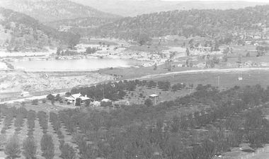
Photograph - Digital Image
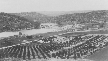
... of farm house surrounded by orchard, with large pond used... copied from a black and white photograph of farm house surrounded ...C Rankins Almond Orchard & Cocks Pioneer Pond, 1930s. Cocks Pioneer Electric Gold & Tin Mine Company was formed in 1899. The company's first power station, located at the eastern end of the valley began operating with its 340 Kilowatt steam-powered generator. By 1909, from 2 500 000 cubic yards worked, reported recovery was 17 284 ounces of gold and 224 tons of tin ore. By 1909, Cocks Pioneer’s power plant had become inadequate and uneconomical. The barge was floated downstream about a mile, but lost time caused the operations to cease. Following testing, a new mine was established by diverting Reid's Creek at a cost of £25 000. Settling dams were built, one of which held 1 935 900 cubic feet. Sold earth banks, built against a wall of stringy bark saplings constructed and laced with vertical props, were built. In 1914, the company was reformed as Cock’s Pioneer Gold and Tin Mines NL, another power station was constructed at the western end of the township, near the junction of Clear and Reid's Creeks. From 6,800,000 cubic yards of material processed, the returns were 64 397 ounces of gold and 855 ton of tin. Cocks Pioneer mine then moved the barge downs stream and continued sluicing. In 1929 Cocks Pioneer Electric Gold and Tin Mining Company ceased operations due to a drop in values. Cock’s Pioneer Gold and Tin Mines NL carried on large-scale hydraulic sluicing operations until 1941. mines, mining, farms, farming, almonds, sluicing, rankins, cocks pioneer, el dorado, eldorado -
 El Dorado Museum Association Inc.
Photograph - Digital Image
... of farm house surrounded by orchard. Large pond used for sluicing... a black and white photograph of farm house surrounded by orchard ...Rankins Orchard and Sluicing Ponds, c1930s.mining, gold, tin, sluicing, orchard, farming -
 Whitehorse Historical Society Inc.
Article, Have your say in Strathdon House, 2015
Whitehorse Council is inviting community feedback.Whitehorse Council is inviting community feedback on the draft report for conservation of the Strathdon Homestead and orchard in Springvale Road, Forest Hill.Whitehorse Council is inviting community feedback. strathdon homestead, springvale road, forest hill, city of whitehorse -
 Whitehorse Historical Society Inc.
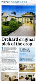
Article, Orchard original pick of the crop, 2011
The pictured house at 17 Milton Street Nunawading was part of the Belmont Orchard Estate with 66 home sites sold in 1924.The pictured house at 17 Milton Street Nunawading was part of the Belmont Orchard Estate with 66 home sites sold in 1924.The pictured house at 17 Milton Street Nunawading was part of the Belmont Orchard Estate with 66 home sites sold in 1924.belmont orchard estate, milton street nunawading, no. 17 -
Whitehorse Historical Society Inc.
Article, A Fruitful History, 2013
... A property review of a 1920s house built in an orchard... Mitcham melbourne Built in an orchard county (2 pages including ...A property review of a 1920s house.A property review of a 1920s house built in an orchard county (2 pages including photos).A property review of a 1920s house.norway avenue blackburn no. 9, peowrie, kevin